
South West England
Encyclopedia
South West England is one of the regions of England
defined by the Government of the United Kingdom
for statistical and other purposes. It is the largest such region in area, covering 9200 square miles (23,828 km²) and comprising Bristol
, Gloucestershire
, Somerset
, Dorset
, Wiltshire
, Devon
, Cornwall
and the Isles of Scilly
. Five million people live there. The region includes the area often known as the West Country
, and much of Wessex
. The size of the region is shown by the fact that the northern part of Gloucestershire, near Chipping Campden
, is as close to the Scottish border as it is to the tip of Cornwall. The largest city is Bristol. Other major urban centres include Plymouth
, Swindon
, Gloucester
, Exeter
, Bath, and the South East Dorset conurbation
of Bournemouth
, Poole
and Christchurch
.
The region includes two National Parks
and four World Heritage Sites, including Stonehenge
.
Traditionally, the South West of England has been well known for producing Cheddar cheese
, which originated in the Somerset
village of Cheddar
, for Devon cream tea
s, Cornish pasties
, and for cider
. It is also well known as the home of the Eden Project
, Aardman Animations
, the Glastonbury Festival
, the Bristol International Balloon Fiesta
, trip hop
music and also Cornwall's surfing
beaches.
Key data and facts about the region are produced by the South West Observatory
.

between the English Channel
and Bristol Channel
. It has the longest coastline of England's regions, totalling 702 miles (1,130 km). Much of the coast is now protected from further substantial development because of its environmental importance, which contributes to the region’s attractiveness to tourists and residents.
Geologically the region is divided into the largely igneous
and metamorphic
west and sedimentary
east, the dividing line slightly to the west of the River Exe
. Cornwall and West Devon's landscape is of rocky coastline and high moorland, notably at Bodmin Moor
and Dartmoor
National Park
. These are due to the granite
and slate
that underlie the area. The highest point of the region is High Willhays
, at 2039 feet (621 m), on Dartmoor
. In North Devon the slates of the west and limestones of the east meet at Exmoor
National Park. The variety of rocks of similar ages seen here have led to the county's name being lent to that of the Devonian
period.
The east of the region is characterised by wide, flat clay vale
s and chalk
and limestone
downland
. The vales, with good irrigation, are home to the region's dairy agriculture. The Blackmore Vale
was Thomas Hardy
's "Vale of the Little Dairies"; another, the Somerset Levels
was created by reclaiming wetlands. The Southern England Chalk Formation
extends into the region, creating a series of high, sparsely populated and archaeologically rich downs, most famously Salisbury Plain
, but also Cranborne Chase
, the Dorset Downs
and the Purbeck Hills
. These downs are the principal area of arable agriculture
in the region. Limestone is also found in the region, at the Cotswolds
, Quantock Hills
and Mendip Hills
, where they support sheep farming. All of the principal rock types can be seen on the Jurassic Coast
of Dorset and East Devon, where they document the entire Mesozoic
era from west to east.
(Cfb) according to the Köppen climate classification
. The oceanic climate typically experiences cool winters with warmer summers and precipitation all year round, with more experienced in winter. Annual rainfall is about 1000 millimetres (39.4 in) and up to 2000 millimetres (78.7 in) on higher ground. Summer maxima averages range from 18 °C (64.4 °F) to 22 °C (71.6 °F) and winter minimum averages range from 1 °C (33.8 °F) to 4 °C (39.2 °F) across the south-west. It is the second windiest area of the United Kingdom, the majority of winds coming from the south-west and north-east. Government organisations predict the region to rise in temperature and become the hottest region in the United Kingdom.
Inland areas of low altitude experience the least amount of precipitation. They experience the highest summer maxima temperatures, but winter minima are colder than the coast. Snowfalls are more frequent in comparison to the coast, but less so in comparison to higher ground. It experiences the lowest wind speeds and sunshine total in between that of the coast and the moors. The climate of inland areas is more noticeable the further north-east into the region.
In comparison to inland areas, the coast experiences high minimum temperatures, especially in winter
, and it experiences slightly lower maximum temperatures during the summer. Rainfall is the lowest at the coast and snowfall is rarer than the rest of the region. Coastal areas are the windiest parts of the peninsula and they receive the most sunshine. The general coastal climate is more typical the further south-west into the region.
Areas of moorland
inland such as: Bodmin Moor
, Dartmoor
and Exmoor
experience lower temperatures and more precipitation than the rest of the south west (approximately twice as much rainfall as lowland areas), because of their high altitude. Both of these factors also cause it to experience the highest levels of snowfall and the lowest levels of sunshine. Exposed areas of the moors are windier than lowlands and can be almost as windy as the coast.
under Cromwell
. (For further information, see Historical and alternative regions of England
). By the 1960s, the South West Region (including Dorset, which for some previous purposes had been included in a Southern region), was widely recognised for government administration and statistics. The boundaries were carried forward into the 1990s, when regional administrations were formally established as Government Office Regions. A regional assembly and regional development agency were added in 1999.
It has been argued that the official South West region does not possess a cultural and historic unity or identity of itself, which has led to criticism of it as an "artificial" construct. The large area of the region, stretching as it does from the Isles of Scilly to Gloucestershire, encompasses diverse areas which have little more in common with each other than they do with other areas of England. The region has several TV stations and newspapers based in different areas, and no single acknowledged regional "capital". Many people of the region have some level of a 'South West', or 'West Country' regional identity, although this may not necessarily correspond to an identification with the official government-defined region
. It is however more common for people in the region to primarily identify at a national level (whether English
, British
, Cornish, or other nations beyond the region itself), and/or a county or city level.
In particular, Cornwall
's inclusion in the region is disputed by Cornish nationalists. The United Kingdom government has stated in the past that Cornwall is too small to become a region in its own right, having around one fifth of the population of the smallest existing English region. The cross-party Cornish Constitutional Convention
and Cornish nationalist party Mebyon Kernow
have campaigned for a Cornish Assembly
ever since the idea of regional devolution was put forward.
 The South West region is largely rural, with small towns and villages; a higher proportion of people live in such areas than in any other English region. The largest cities and towns are Bristol
, Plymouth
, Bournemouth
and Poole
(collectively the South East Dorset conurbation
), Swindon
, Gloucester
, Cheltenham
, Torbay
, Exeter
, Bath, Weston-super-Mare
, Salisbury, Taunton
and Weymouth. The population of the South West is about five million.
runs from London to Bristol, Exeter, Plymouth and Penzance
in the far west of Cornwall. The South Western Main Line
runs from London and Southampton to Bournemouth, Poole and Weymouth in Dorset. The West of England Main Line
runs from London to Exeter via south Wiltshire, north Dorset and south Somerset. The Wessex Main Line
runs from Bristol to Salisbury and on to Southampton. The Heart of Wessex Line
runs from Bristol
in the north of the region to Weymouth on the south Dorset
coast via Westbury
, Castle Cary
and Yeovil
, with most services starting at Gloucester
.
Three major roads enter the region from the east. The M4 motorway
from London to South Wales via Bristol is the busiest. The A303
cuts through the centre of the region from Salisbury to Honiton
, where it merges with the A30
to continue past Exeter to the west of Cornwall. The A31
, an extension of the M27
, serves Poole and Bournemouth and the Dorset coast. The M5
runs from the West Midlands
through Gloucestershire, Bristol and Somerset to Exeter. The A38
serves as a western extension to Plymouth. There are three other smaller motorways in the region, all in the Bristol area
.
Passenger airports in the region include Bristol
, Exeter
, Plymouth
, Newquay and Bournemouth
.
Within the region the local transport authorities carry out transport planning through the use of a Local Transport Plan (LTP)
which outlines their strategies, policies and implementation programme. The most recent LTP is that for the period 2006-11. In the South West region the following transport authorities have published their LTP online: Bournemouth
U.A., Cornwall
U.A., Devon
, Dorset
, Gloucestershire
, Plymouth
U.A., Somerset
, Swindon
U. A., Torbay
U. A. and Wiltshire unitary authority
. The transport authorities of Bath and North East Somerset
U. A., Bristol
U. A., North Somerset
U. A. and South Gloucestershire
U. A. publish a single Joint Local Transport Plan as part of the West of England Partnership
.
from flint
artefacts
in a quarry at Westbury
that an ancestor
of modern man, possibly Homo heidelbergensis
, was present in the future Somerset from around 500,000 years ago. There is some evidence of human occupation of southern England before the last ice age
, such as Kents Cavern in Devon, but largely in the south east
. The British mainland was connected to the continent during the ice age and humans may have repeatedly migrated into and out of the region as the climate fluctuated. There is evidence of human habitation in the caves at Cheddar Gorge 10,000–11,000 years BC, during a partial thaw in the ice age. The earliest scientifically dated cemetery
in Britain
was found at Aveline's Hole
in the Mendip Hills
. The human bone fragments it contained, from about 21 different individuals, are thought to be between roughly 10,200 and 10,400 years old. During this time the tundra gave way to birch
forest
s and grassland
and evidence for human settlement appears at Salisbury Plain
, Wiltshire and Hengistbury Head
, Dorset.
At the end of the last Ice Age the Bristol Channel
was dry land but subsequently the sea level rose, resulting in major coastal changes. The Somerset Levels
became flooded, but the dry point
s such as Glastonbury
and Brent Knoll
are known to have been occupied by Mesolithic
hunters. The landscape at this time was tundra
. Britain's oldest complete skeleton, Cheddar Man
, lived at Cheddar Gorge around 7150 BC (the Upper Palaeolithic or Old Stone Age), shortly after the end of the ice age; however it is unclear whether the region was continually inhabited during the previous 4,000 years, or if humans returned to the gorge after a final cold spell. A Palaeolithic flint tool found in West Sedgemoor is the earliest indication of human presence on the Somerset Levels. During the 7th millennium BC the sea level rose and flooded the valleys so the Mesolithic
people occupied seasonal camps on the higher ground, indicated by scatters of flints. The Neolithic
people continued to exploit the reedswamps for their natural resources and started to construct wooden track ways. These included the Post Track
and the Sweet Track
. The Sweet Track, dating from the 3800s BC
, is the world's oldest timber trackway
and was once thought to be the world's oldest engineered road
way. The Levels were also the location of the Glastonbury Lake Village
as well as two at Meare
. Stonehenge
and Avebury
are perhaps the most famous Neolithic sites in the UK.
The region was heavily populated during the Neolithic, Bronze Age
and Iron Age
periods. Many monuments, barrows and trackways exist. Coin evidence shows that the region was split between the Durotriges
, Dobunni
and Dumnonii
. The Iron Age tribe in Dorset were the Durotriges, "water dwellers", whose main settlement is represented by Maiden Castle
. Ptolemy
stated that Bath was in the territory of the Belgae
, but this may be a mistake. The Celtic gods were worshipped at the temple
of Sulis
at Bath and possibly the temple on Brean Down
. Iron Age sites on the Quantock Hills
, include major hill fort
s at Dowsborough
and Ruborough, as well as smaller earthwork enclosures, such as Trendle Ring
, Elworthy Barrows
and Plainsfield Camp
.
At the time of the Roman invasion, the inhabitants of the entire area that would later be included in the region spoke a Brythonic Celtic
language. Languages descendant from that language are still spoken in Cornwall
, Wales
, and Brittany
.
, the east of the region, particularly in the Cotswolds and eastern Somerset, was heavily Romanised but was much less so in Devon and Cornwall, though Exeter was a regional capital. Villas, farms and temples relating to the period exist in the region, including the remains at Bath.
The area now comprising the county of Somerset
was part of the Roman Empire
from 47 AD to about 409 AD. However, the end was not abrupt and elements of Romanitas
lingered on for perhaps a century. Somerset was invaded from the south-east by the Second Legion
Augusta, under the future emperor Vespasian
. The hillforts of the Durotriges
at Ham Hill
and Cadbury Castle
were captured. Ham Hill probably had a temporary Roman occupation. The massacre at Cadbury Castle
seems to have been associated with the later Boudiccan Revolt of 60-61 AD. The area remained part of the Roman Empire
until around 409 AD.
 The Roman invasion, and possibly the preceding period of involvement in the internal affairs of the south of England, was inspired in part by the potential of the Mendip Hills
. A great deal of the attraction of the lead mines may have been the potential for the extraction of silver
. Forts were set up at Bath and Ilchester
. The lead and silver mines
at Charterhouse
in the Mendip Hills
were run by the military
. The Romans established a defensive boundary along the new military road known the Fosse Way
(from the Latin
fossa meaning ditch). The Fosse Way ran through Bath, Shepton Mallet
, Ilchester
and south-west towards Axminster
. The road from Dorchester ran through Yeovil
to meet the Fosse Way at Ilchester
. There was salt
production on the Somerset Levels
near Highbridge
and quarry
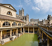
ing took place near Bath, where the Roman Baths gave their name to Bath.
Excavations carried out before the flood
ing of Chew Valley Lake
also uncovered Roman remains, indicating agricultural and industrial activity from the second half of the 1st century until the 3rd century AD. The finds included a moderately large villa
at Chew Park, where wooden writing tablets (the first in the UK) with ink writing were found. There is also evidence from the Pagans Hill Roman Temple
at Chew Stoke
. In October 2001 the West Bagborough Hoard
of 4th century Roman
silver
was discovered in West Bagborough
. The 681 coins included two denarii from the early 2nd century and 8 Miliarense
and 671 Siliqua
all dating to the period AD 337 – 367. The majority were struck in the reigns of emperors Constantius II
and Julian
and derive from a range of mints including Arles
and Lyon
s in France, Trier
in Germany and Rome
. In April 2010, the Frome Hoard
, one of the largest-ever hoards of Roman
coins discovered in Britain, was found by a metal detectorist. The hoard of 52,500 coins dated from the 3rd century AD and was found buried in a field near Frome
, in a jar 14 inches (35.6 cm) below the surface. The coins were excavated by archaeologists from the Portable Antiquities Scheme
.
, centred around the old tribal territory of the Dumnonii
. The upper Thames area soon came under Anglo-Saxon control but the remainder of the region was British controlled until the 6th century. A large defensive ditch on Cranborne Chase
, Bokerley Dyke
, dated to 367, delayed the Saxon
conquest of Dorset, with the Romano-British remaining in Dorset for 200 years after the withdrawal of the Roman legions. The Western Wandsdyke
was probably built during the 5th or 6th century. This area became the border between the Romano-British
Celt
s and the West Saxons
following the Battle of Deorham
in 577 AD. The Anglo-Saxons then gained control of the Cotswold area but most of Somerset, Dorset and Devon (as well as Cornwall) remained in British hands until the late 7th century. According to the Anglo-Saxon Chronicle
, the Saxon Cenwalh
achieved a breakthrough against the British
Celtic tribes, with victories at Bradford-on-Avon (in the Avon Gap in the Wansdyke) in 652 AD, and further south at the Battle of Peonnum
(at Penselwood
) in 658 AD, followed by an advance west through the Polden Hills
to the River Parrett
. The Saxon advance from the east seems to have been halted by battles between the British and Saxons, for example; at the siege of Badon Mons Badonicus (which may mave been in the Bath region e.g. at Solsbury Hill
), or Bathampton Down
. The Battle of Bedwyn was fought in 675 between Escuin
, a West Saxon
nobleman who had seized the throne of Queen Saxburga
, and King Wulfhere of Mercia
. The earliest fortification of Taunton
started for King Ine of Wessex
and Æthelburg, in or about the year 710 AD. However, according to the Anglo-Saxon Chronicle
this was destroyed 12 years later. Alfred the Great
refortified Exeter as a defensive burh
, followed by new erections at Lydford
, Halwell
and Pilton
, although these fortifications were relatively small compared to burh
s further east, suggesting these were protection for only the elite. The English defeated a combined Cornish and Danish force at Callington in 832. Edward the Elder
built similarly at Barnstaple
and Totnes
. Sporadic Viking incursions continued, however, until the Norman Conquest, including the disastrous defeat of the Devonians at the Battle of Pinhoe
. In 876 King Alfred the Great
trapped a Danish fleet at Arne
then drove it out, 120 ships being wrecked at Studland
. Although King Alfred had lands in Cornwall, it continued to have a British king. It is generally considered that Cornwall
came fully under the dominion of the English Crown in the time of Athelstan
's rule, i.e. 924-939. In the absence of any specific documentation to record this event, supporters of Cornwall's "English status" presume that it was made a part of England as a result. However, within a mere five years of Athelstan's death, King Edmund
issued a charter, in AD 944, styling himself "King of the English and ruler of this province of the Britons". Thus we can see that then the "province" was a territorial possession, which has long claimed a special relationship to the English Crown.
Corfe Castle
in 978 saw the murder of King Edward the Martyr
, whose body was taken first to Wareham
and then to Shaftesbury
. Somerset played an important part in defeating the spread of the Danes in the 9th century. Viking
raids took place for instance in 987 and 997 at Watchet
and the Battle of Cynwit. King Alfred
was driven to seek refuge from the Danes at Athelney
before defeating them at the Battle of Ethandun in 878, usually considered to be near Edington, Wiltshire
, but possibly the village of Edington
in Somerset. Alfred established a series of forts and lookout posts linked by a military road, or Herepath
, so his army could cover Viking movements at sea. The Herepath has a characteristic form which is familiar on the Quantocks: a regulation 20 m wide track between avenues of trees growing from hedge laying
embankments. A peace treaty with the Danes was signed at Wedmore
and the Danish king Guthrum the Old
was baptised at Aller
. Burh
s (fortified places) had been set up by 919, such as Lyng
. The Alfred Jewel
, an object about 2.5 inches (63.5 mm) long, made of filigree gold, cloisonné
-enamelled and with a rock crystal covering, was found in 1693 at Petherton Park, North Petherton
. Believed to have been owned by Alfred the Great
Monasteries and minster
churches were set up all over Somerset, with daughter churches from the minsters in manors. There was a royal palace at Cheddar
, which was used at times in the 10th century to host the Witenagemot
.
During the latter part of the pre-Norman period, the eastern seaboard of modern day England became increasingly under the sway of the Norse
. Eventually England became ruled by Norse monarchs, and the Anglo-Saxon
kingdoms fell one by one, with Wessex
being conquered in 1013 by King Sweyn Forkbeard. Notably, while Sweyn's realms, which included Denmark
and Norway
in the north, and modern day English areas such as Mercia
(an Anglian kingdom of the current Midlands
), much of which, along with northern England, fell under the "Danelaw
". But while Sweyn ruled Wessex, along with his other realms, from 1013 onwards, followed by his son Canute the Great
, Cornwall was not part of his realm of Wessex. A map by the American historian called the "The Dominions of Canute" (pictured just above) show that Cornwall, like Wales and Scotland, was neither part of Sweyn Forkbeard's nor Canute's Danish empire. Neither Sweyn Forkbeard nor Canute properly conquered or controlled Scotland, Wales or Cornwall; these modern day Celtic nations were both "client nations" who had to pay a yearly tribute or danegeld
to both Sweyn and Canute, but, provided they did so, Scotland, Wales and Cornwall could keep their autonomy from the Danes. Ultimately, the Danes' control of Wessex was lost in 1042 with the death of both of Canute's sons (Edward the Confessor
retook Wessex for the Saxons). In 1016 Edmund Ironside
was crowned king at Glastonbury.
lords and later by local gentry, a few of which appear to have descended from pre Conquest families. During the civil war
of King Stephen
’s reign, the castles of Plympton and Exeter
were held against the king by Baldwin de Redvers
in 1140 and this gave rise to the defensive castles at Corfe Castle
, Powerstock
, Wareham
and Shaftesbury
. The period saw the growth of towns such as Truro
, Totnes
, Okehampton
and Plympton
in the western part of the region but they remained small when compared with the established wealth of ancient cathedral cities of the eastern region such as Exeter
, Bath and Wells
. Wealth grew from sheep farming in the east of the region, church controlled estates such as Glastonbury Abbey
and Wells
becoming among the richest in England, while tin
and silver mining was important in Devon and Cornwall with the establishment of Stannary Parliaments with semi-autonomous powers. Farming prospered until it was severely hit by the Black Death
which in 1348 arrived in Dorset
and quickly spread through Somerset, causing widespread mortality, perhaps as much as 50% in places. It re-occurred, resulting in a change in feudal practices since the manpower was no longer so available. Crafts and industries also flourished, the Somerset woollen industry being one of the largest in England at this time. Coal mining
on the Mendips
was an important source of wealth while quarry
ing also took place.
Many parish churches were re-built in this period. Between 1107 and 1129 William Giffard
the Chancellor of King Henry I
, converted the bishop's hall in Taunton into Taunton Castle
. It was his successor, Henry of Blois
, who transformed the manor-house here into a mighty castle in 1138. Bridgwater Castle
was built in 1202 by William Brewer
. It passed to the king in 1233 and in 1245 repairs were ordered to its motte and towers. During the 11th century Second Barons' War
against Henry III
, Bridgwater was held by the barons against the King. During the Middle Ages
sheep farming for the wool trade came to dominate the economy of Exmoor
. The wool was spun into thread on isolated farms and collected by merchants to be woven, fulled, dyed and finished in thriving towns such as Dunster
. The land started to be enclosed and from the 17th century onwards larger estates developed, leading to establishment of areas of large regular shaped fields. During this period a Royal Forest
and hunting ground was established, administered by the Warden. The Royal Forest was sold off in 1818.
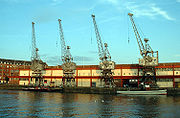
Where conditions were suitable, coastal villages and ports had an economy based on fishing. The larger ports such as Fowey
contributed vessels to the naval enterprises of the King and were subject to attack from the French in return. Bridgwater was part of the Port of Bristol
until the Port of Bridgwater was created in 1348, covering 80 miles (128.7 km) of the Somerset coast line, from the Devon
border to the mouth of the River Axe. Historically, the main port on the river was at Bridgwater; the river being bridged at this point, with the first bridge being constructed in 1200 AD. Quays were built in 1424; with another quay, the Langport slip, being built in 1488 upstream of the Town Bridge. In Bristol
the port began to develop in the 11th century. By the 12th century Bristol was an important port, handling much of England's trade with Ireland. During this period Bristol also became a centre of shipbuilding and manufacturing. Bristol was the starting point for many important voyages, notably John Cabot
's 1497 voyage of exploration to North America. By the 14th century Bristol was one of England's three largest medieval towns after London, along with York
and Norwich
, with perhaps 15,000–20,000 inhabitants on the eve of the Black Death
of 1348–49.
The plague resulted in a prolonged pause in the growth of Bristol's population, with numbers remaining at 10,000–12,000 through most of the 15th and 16th centuries.
 During the Wars of the Roses
, frequent skirmishes took place between the Lancastrian
Earl of Devon and Yorkist
Lord Bonville. In 1470, Edward IV
pursued Warwick
and Clarence
as far as Exeter after the Battle of Lose-coat Field
. The organization of the region remained based on the shires and Church estates, which were largely unchanged throughout the period. Early in Henry VII
's reign, the Royal pretender, Perkin Warbeck
, besieged Exeter in 1497. The Cornish Rebellion of 1497
led by An Gof
and Thomas Flamank
also took place in 1497, involving a march to Blackheath
in London
where the Cornish
forces were defeated and massacred. Great disturbances throughout both Cornwall
and Devon
followed the introduction of Edward VI
's Book of Common Prayer
. The day after Whit Sunday 1549, a priest at Sampford Courtenay
was persuaded to read the old mass
. This insubordination spread swiftly into serious revolt. The Cornish
quickly joined the men of Devon in the Prayer Book Rebellion
and Exeter suffered a distressing siege until relieved by Lord Russell. The Cornish had a particular motivation for opposing the new English language prayer book, since in western parts of Cornwall at this time, there continued to be many monoglot Cornish
speakers. The Cornish language
declined rapidly afterwards and the Dissolution of the Monasteries
resulted in the eventual loss of the Cornish language as a primary language. The Cornish
retreated westward until it was no longer a first language by the end of the 18th century.
During the reign of Elizabeth I
there was a Council of the West
which was a short-lived administrative body established by Henry VIII of England
for the government of the western counties of England. It was analogous in form to the Council of the North
. The Council was established in March 1539, with Lord Russell
as its Lord President. Members included Thomas Derby, Sir Piers Edgcumbe, Sir Richard Pollard and John Rowe. However, the fall of Thomas Cromwell
, the chief political supporter of government by Councils, and the tranquillity of the western counties made it largely superfluous. It last sat in the summer of 1540, although it was never formally abolished.
The Bristol Channel floods of 1607
are believed to have affected large parts of the Somerset Levels
with flooding up to 8 feet (2 m) above sea level. In 1625, a House of Correction was established in Shepton Mallet
and, today, HMP Shepton Mallet
is England's oldest prison
still in use.
During the English Civil War
, Somerset was largely Parliamentarian
, although Dunster
was a Royalist stronghold. The county was the site of important battles between the Royalists
and the Parliamentarians
, notably the Battle of Lansdowne
in 1643 and the Battle of Langport
in 1645. Bristol was occupied by Royalist
military, after they overran Royal Fort
, the last Parliamentarian
stronghold in the city. Taunton Castle
had fallen into ruin by 1600 but it was repaired during the Civil War. The castle changed hands several times during 1642-45 along with the town. During the Siege of Taunton
it was defended by Robert Blake
, from July 1644 to July 1645. After the war, in 1662, the keep was demolished and only the base remains. This war resulted in castles being destroyed to prevent their re-use.
 In 1685, the Duke of Monmouth
led the Monmouth Rebellion
in which Somerset people fought against James II
. The rebels landed at Lyme Regis
and travelled north hoping to capture Bristol
and Bath, puritan soldiers damaged the west front of Wells Cathedral
, tore lead from the roof to make bullets, broke the windows, smashed the organ and the furnishings, and for a time stabled their horses in the nave. They were defeated in the Battle of Sedgemoor
at Westonzoyland
, the last battle fought on English soil. The Bloody Assizes
which followed saw the losers being sentenced to death or transportation
. At the time of the Glorious Revolution
, King James II
gathered his main forces, altogether about 19,000 men, at Salisbury
, James himself arriving there on 19 November 1688. The first blood was shed at Wincanton
, in Somerset
. In Salisbury, James heard that some of his officers, such as Edward Hyde
, had deserted, and he broke out in a nose-bleed which he took as a bad omen. His commander in chief, the Earl of Feversham
, advised retreat on 23 November, and the next day John Churchill
deserted to William. On 26 November, James's daughter Princess Anne
did the same, and James returned to London the same day, never again to be at the head of a serious military force in England.
has grown to become the largest city in Devon, mainly due to the naval base at Devonport
. Her Majesty's Naval Base (HMNB) Devonport
is one of three operating bases in the United Kingdom for the Royal Navy
. HMNB Devonport is now the largest naval base in Western Europe
. The large Portland Harbour
, built at the end of the 19th century and protected by Nothe Fort
and the Verne Citadel
, was for many years, including during the wars, another of the largest Royal Navy bases.
The 19th century saw improvements to roads in the region with the introduction of turnpikes and the building of canals and railways. The usefulness of the canals was short-lived, though they have now been restored for recreation. Chard
claims to be the birthplace of powered flight
, in 1848 when the Victorian aeronautical pioneer John Stringfellow
first demonstrated that engine-powered flight was possible through his work on the Aerial Steam Carriage
. North Petherton
was the first town in England (and one of the few ever) to be lit by acetylene
gas lighting.
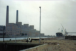 Around the 1860s, at the height of the iron and steel era, a pier
and a deep-water dock
were built, at Portishead
to accommodate the large ships that had difficulty in reaching Bristol Harbour
. The Portishead power station
s were coal-fed power station
s built next to the dock. Industrial activities ceased in the dock with the closure of the power stations. The Port of Bristol Authority finally closed the dock in 1992, and it has now been developed into a marina and residential area.
During the First World War many soldiers from the South West were killed, and war memorials were put up in most of the towns and villages; only a few villages escaped casualties. There were also casualties – though much fewer – during the Second World War, who were added to the memorials. Several areas were bases for troops preparing for the 1944 D-Day
landings. Exercise Tiger
, or Operation Tiger, was the code names for a full-scale rehearsal in 1944 for the D-Day
invasion of Normandy
. The British Government evacuated approximately 3,000 local residents in the area of Slapton
, now South Hams District
of Devon
. Some of them had never left their villages before. Bristol's city centre suffered severe damage from Luftwaffe
bombing during the Bristol Blitz
of World War II. The Royal Ordnance Factory
ROF Bridgwater
was constructed early in World War II
for the Ministry of Supply. The Taunton Stop Line
was set up to resist a potential German invasion, and the remains of its pill boxes
can still be seen, as well as others along the coast.
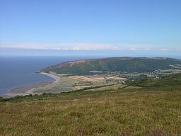 Exmoor
was one of the first British National Parks, designated in 1954, under the 1949 National Parks and Access to the Countryside Act. and is named after its main river
. It was expanded in 1991 and in 1993 Exmoor was designated as an Environmentally Sensitive Area
. The Quantock Hills
were designated as an Area of Outstanding Natural Beauty
(AONB) in 1956, the first such designation in England under the National Parks and Access to the Countryside Act 1949
. The Mendip Hills
followed with AONB designation in 1972.
Hinkley Point A nuclear power station
was a Magnox
power station
constructed between 1957 and 1962 and operating until ceasing generation in 2000. Hinkley Point B
is an Advanced Gas-cooled Reactor (AGR) which was designed to generate 1250 MW of electricity (MWe). Construction of Hinkley Point B started in 1967. In September 2008 it was announced, by Electricité de France
(EDF), that a third, twin-unit European Pressurized Reactor
(EPR) reactor known as Hinkley Point C
is planned, to replace Hinkley Point B which is due for closure in 2016.
According to the 2001 census
the population of the South West region was 4,928,434. It had grown in the last 20 years by 12.5% from 4,381,400 in mid-1981, making it the fastest growing region in England. Teignbridge
in Devon
had the largest population gain with 26.3% and Devon as whole grew by 17.6%. Population falls occurred in the two major cities of Bristol
and Plymouth
.
having the lowest rate for council districts.
, the region shows similarities with Southern England
in having more Lower Layer Super Output Areas in the 20% least multiple derived
districts than the 20% most deprived. The relative amount of deprivation is similar to the East Midlands
, except the South West has much fewer deprived areas. According to the LSOA data in 2007, the most deprived districts (before Cornwall became a unitary authority) were, in descending order - Bristol (64th in England), Torbay (71st), Plymouth (77th), Kerrier
(86th), Restormel
(89th), North Cornwall
(96th), and West Somerset (106th). At county level, the deprived areas are City of Bristol (49th in England), Torbay (55th), Plymouth (58th), and Cornwall and the Isles of Scilly (69th).
The least deprived council districts are, in descending order - East Dorset, North Wiltshire, South Gloucestershire, Cotswold, Kennet, Stroud, Tewkesbury, West Wiltshire, Salisbury, and Bath and North East Somerset. East Dorset has the highest life expectancy for males in the UK. At county level, the least deprived areas, in descending order, are South Gloucestershire, Wiltshire, Bath and North East Somerset, Dorset, Gloucestershire, Poole, North Somerset, and Somerset.
In March 2011 the region had the second lowest unemployment claimant
count in England, second to South East England
, with 2.7%. Inside the region, Torbay
has the highest rate with 4.5%, followed by Bristol and Plymouth with 3.8%. East Dorset
has the lowest rate with 1.4%.
For the region's electorate, 43% voted Conservative, 35% voted Liberal Democrat, and Labour came third with 15%. The distribution of seats is weighted in favour of the Conservatives with 36 Conservative, 15 Liberal Democrat and 4 Labour (Plymouth Moor View, Exeter
, Bristol South and Bristol East
). The Conservatives gained 11 seats, with the others (mostly Labour - 8) losing seats. Somerset and Cornwall are the strongest areas for the Liberal Democrats, with Gloucestershire, Devon, Dorset and Wiltshire being more Conservative.
In the 2009 European Election
, 30% voted Conservative, 22% UKIP, 17% Liberal Democrat, 9% Green, and 8% Labour. Labour and the Greens have no MEPs.
 The most economically productive areas within the region are Bristol, the M4 corridor
and south east Dorset which are all areas with the best links to London. Bristol alone accounts for a quarter of the region's economy, with the surrounding areas of Gloucestershire, Somerset and Wiltshire accounting for a further quarter. The South West of England Regional Development Agency is based in Exeter (although this is expected to cease operations by March 2012, its functions being generally replaced by Local Enterprise Partnership
s), and the South West Strategic Leaders' Board (which makes funding decisions) is in Taunton.
Bristol's economy has been built on maritime trade (including the import of tobacco and the slave trade). Since the early 20th century, however, aeronautics
have taken over as the basis of Bristol's economy, with companies including Airbus UK
, Rolls-Royce
(military division) and BAE Systems
(former Bristol Aeroplane Company
then BAC
) manufacturing in Filton
. Defence Equipment and Support is at MoD Abbey Wood
. More recently defence, telecommunications, information technology and electronics have been important industries in Bristol, Swindon and elsewhere. VOSA
, the Soil Association
, Clerical Medical
, the Arts and Humanities Research Council
, Bristol Water
, and the Bristol and West
Bank are in Bristol; Orange United Kingdom
and the Environment Agency
are based at Aztec West
(South Gloucestershire); Indesit
makes tumble dryer
s in Yate
; and HP
have a large site and Infineon Technologies UK
are at Stoke Gifford
. Knorr-Bremse UK
make air brake
s in Kingswood
. The South West Observatory
's Economy Module provides a detailed analysis of the region's economy.
The electricity for the area
formerly looked after by SWEB
, is now looked after by Western Power Distribution
, owned by the American company, PPL
.
The region's Gross value added
(GVA) breaks down as 69.9% service industry, 28.1% production industry
and 2.0% agriculture
. This is a slightly higher proportion in production, and lower proportion in services, than the UK average. Agriculture, though in decline, is important in many parts of the region. Dairy farming
is especially important in Dorset and Devon, and the region has 1.76 million cattle, second to only one other UK region, and 3520 square miles (9,117 km²) of grassland, more than any other region. Only 5.6% of the region's agriculture is arable.
Tourism is important in the region, and in 2003 the tourist sector contributed £4,928 million to the region's economy.
In 2001 the GVA of the hotel industry was £2,200 million, and the region had 13,800 hotels with 250,000 bed spaces.
There are very large differences in prosperity between the eastern parts of the region and the west. While Bristol is the second most affluent large city in England after London, some parts of Cornwall and Devon have among the lowest average incomes in the UK.
Cornwall in particular relies on tourism. The county has the lowest GVA per head of any county or unitary authority in the country, contributes only 6.5% of the region's economy and receives EU Objective One funding. Around five million people visit the county each year. Cornwall's poor economic performance is partly caused by its remoteness and poor transport links, and by the decline of its traditional industries, such as mining
, agriculture and fishing.
NHS South West
, the strategic health authority
is based in Taunton off junction 25 of the M5. The Devon Air Ambulance is based at the Devon and Cornwall Police HQ in Exeter; the Cornwall Air Ambulance
is at Newquay Cornwall Airport; Dorset and Somerset Air Ambulance
is at Henstridge
east of Yeovil on the A30
; the Great Western Air Ambulance is at Bristol Filton Airport (one of the last in the UK when it began in June 2008); and the Wiltshire Air Ambulance
(shared with the police) is at Devizes
(police HQ). The South Western Ambulance Service
is on the Sowton
Industrial Estate, next to the M5, half a mile east of the police HQ. The region's Manufacturing Advisory Service
is on the A38
north of Gloucester at Twigworth
, its Business Link
is in central Swindon
, and the UKTI
office is at the Leigh Court Business Centre in Abbots Leigh
, North Somerset
.
who are major producers of kaolin, Dairy Crest
who have their main cheese creamery in Davidstow
making Cathedral City Cheddar
on the former RAF Davidstow Moor
, and Ginsters
have a food production plant in Callington. Rodda's make clotted cream
near Scorrier
, off the A30 east of Redruth.
 The Met Office
is in Exeter
as is Connaught plc
, and Pennon Group
, the water company. The airline Flybe
is based at Exeter Airport. Wm. Wrigley Jr. Company UK
(chewing gum) and HMNB Devonport
(the largest naval base in western Europe) are in Plymouth. Hemerdon Mine
, east of Plymouth, has one of the largest deposits of tungsten in the world. Britannia Royal Naval College
is at Dartmouth
. Beverage Brands, maker of WKD Original Vodka
, is in Torquay
.
All Ambrosia
products are made in Lifton. Parkham Farms make Westcountry Farmhouse Cheddar at Woolfardisworthy, Torridge
. Supacat
at Dunkeswell Aerodrome
, north of Honiton
, make protective vehicles for the Army, notably the Jackal. These vehicles are also made in Plymouth by Devonport Management Limited
(DML). Centrax
make industrial gas turbines in Newton Abbot
.
are headquartered in Bournemouth and Merlin Entertainments
(who own Sea Life Centres
) is in Poole
as well as Lush, the cosmetics company, and the Royal National Lifeboat Institution
(RNLI). Ryvita
is made in Parkstone
. New Look is in Weymouth. Hall & Woodhouse
brewery is in Blandford Forum (home of the Royal Corps of Signals
).
 Endsleigh Insurance
, Kraft Foods UK
, UCAS
, Kohler Mira Ltd
(shower
s), Spirax-Sarco Engineering Plc
, Chelsea Building Society
, GE Aviation Systems UK (former Smiths Group
), and GCHQ
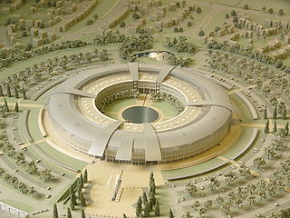
(also in Oakley
) are in Cheltenham. The Cheltenham & Gloucester
bank is Barnwood
(north Gloucester) next to Unilever
's manufacturing site for Wall's (company)
ice cream on the A417
. Computer security firm Symantec
have a site in Gloucester. Dowty Rotol
(who make propellors), Messier-Dowty
, Messier-Dowty UK
and Bond Aviation Group
are next to Gloucestershire Airport
at Staverton
.
The Colt Car Company UK
(who distribute Mitsubishi Motors
) are in Cirencester
. The Stroud & Swindon Building Society
and Ecotricity
are in Stroud
. GSK
makes Lucozade
and Ribena
at Coleford
in the Forest of Dean
. Dairy Crest
makes Frijj
milkshake at its large dairy at Severnside
at Stonehouse
next to the M5. Mabey Group
make steel girder bridge
s in Lydney
. The Fire Service College
is in Moreton-in-Marsh
.
have a large base for 40 Commando
near Taunton
, with their training centre
at Lympstone
in Devon
. Screwfix
is in Yeovil and Clarks shoes
is in Street
, although most of its shoes are made in the Far East. Leisure Connection is in Shepton Mallet
, home of Blackthorn Cider
and the Gaymer Cider Company
. Thatchers Cider is in Sandford
, North Somerset
on the A368
, two miles east of the M5. Uniq Desserts make premium chilled desserts, such as tiramisu
for M & S, at their site (former St Ivel
) off the B3081 at Evercreech
. Dairy Crest
packs Cathedral City
cheese in Frome
. Wessex Water
, Future plc, and Rotork
are in Bath. The Glastonbury Festival
at Pilton
(nearer to Shepton Mallet than Glastonbury), off the A361
, is the UK's biggest music festival.
Cadbury used to make Curly Wurly, Double Decker
and Crunchie
at the Somerdale Factory
, Keynsham
until Kraft closed the plant in March 2011 and moved production to Skarbimierz, Opole Voivodeship
in Poland. Westland Helicopters
(now AgustaWestland
) is in Yeovil
and Weston-super-Mare
. Yeo Valley Organic
is in Blagdon
. Numatic International Limited
makes vacuum cleaner
s and Dairy Crest
makes brandy butter in Chard
. The United Kingdom Hydrographic Office
is in Taunton.
 The Early Learning Centre
is in South Marston
. Nearby, Castrol
, the Nationwide Building Society
, Research Councils UK
and five research councils, Intel Europe
, the British Computer Society
, a main office of English Heritage
, and the National Trust
(responsible for the area of the UK except Scotland) are in Swindon. In Stratton St Margaret
, BMW
press metal for the MINI
at Swindon Pressings Ltd
, there is a major Honda manufacturing plant (also in South Marston), and the headquarters of W H Smith
. Near junction 16 of the M4, close to Freshbrook
, are Synergy Health
and RWE npower
, near the A3102/B4534 roundabout. Triumph International UK
is in Blunsdon St Andrew
.
Dyson is in Malmesbury. In Devizes
is the Wadworth Brewery
. Cereal Partners make Shredded Wheat
and Shreddies
at Staverton
. Virgin Mobile
is in Trowbridge, as is Danone UK
(owner of Actimel
) and their Cow & Gate subsidiary (run by Numico
). Salisbury Cathedral
in Salisbury
attracts many tourists. Nearby, Dstl
is at Porton Down
. Knorr-Bremse Rail Systems UK
(former Westinghouse) make railway air brakes in Bowerhill just south of Melksham
and nearby is the headquarters of Avon Rubber
. Cooper Tire & Rubber Company
also make Avon Tyres in the same town. Chippenham
has the HQ of Wincanton plc
, the large logistics
company, and Invensys Rail Group (former Westinghouse Rail Systems
) who make rail signalling equipment
, and the software company SciSys
. In the centre of the county are many military establishments, notably MoD Boscombe Down
, the training base on Salisbury Plain
, and the army bases around Tidworth
, Larkhill
(home of the Royal School of Artillery
) and Warminster
(home of the Infantry
).
(omitting only Hampshire
and Berkshire
), and all of the Celtic Kingdom of Dumnonia
which comprised Cornwall, Devon, and parts of Somerset and Dorset. In terms of local government, it was divided after 1974 into Avon
, Cornwall
, Devon
, Dorset
, Gloucestershire
, Somerset
, and Wiltshire
. Avon has since been abolished, and several mainly urban areas have become unitary authorities.
UA = unitary authority
CC = county council
 Although referendums had been planned on whether elected assemblies should be set up in some of the regions, none was planned in the South West. The South West Regional Assembly
(SWRA) was the regional assembly
for the South West region, established in 1999. It was based in Exeter
and Taunton
. The SWRA was a partnership of councillors from all local authorities in the region and representatives of various sectors with a role in the region's economic, social and environmental well-being. There was much opposition to the formation of the SWRA with critics saying it was an unelected unrepresentative and unaccountable "quango". The Regional Assembly was wound up in May 2009, and its functions taken on by the Strategic Leaders' Board (SLB) of South West Councils.
hold 36 seats, the Liberal Democrats
15 and Labour
4.
South West England
is one of the constituencies used for elections to the European Parliament
. From the 2004 election onwards, Gibraltar
has been included within the constituency for the purpose of elections to the European parliament only. As of the 2009 European Parliament election
, it is represented by three Conservative
, two UKIP
and one Liberal Democrat
Member of European Parliament (MEP).
, the former area of Avon, Swindon
and Cornwall
have comprehensive school
s. The other counties have some selective grammar school
s. Gloucestershire
has six, Wiltshire
has two (both in Salisbury
), Poole
has two, Bournemouth
has two, Devon
has one, Plymouth
has three and Torbay
has three.
There are around 205,000 at secondary schools in the region, the third lowest total after the North East
and the East Midlands
. The region has fairly low overall truancy
. At secondary schools Bristol has the highest rate of persistent truants with 6.0%; Purbeck (Dorset) has the lowest rate with 2.3%, followed by East Dorset
with 2.6%.
At GCSE
in 2009, Bath and North East Somerset consistently performs the best, closely followed by Gloucestershire, Poole, and Wiltshire. Also above the UK average are Dorset, Torbay, North Somerset, Devon, Bournemouth, and Torbay, in descending order. The South West performs well at GCSE, with the only exception being the City of Bristol which is very low performing, and to a smaller extent, Swindon.
At A-level
in 2009, Bournemouth performs the best, and does so consistently every year, ahead of all the other areas including most of England. Gloucestershire again performs well, being next best, closely followed by Wiltshire. These areas and Somerset are the only ones in the South-West above the England average, and the top three out of the four have some selective schools and are the only three to perform above average at A-level and GCSE. Poole received much lower A-level results than normal in 2009. At A-level, the South West is not quite as well performing as other areas. Dorset does not perform much lower at A-level than GCSE on average, but Bristol performs much better at A-level than GCSE. Plymouth performs the worst, although Swindon has had that position in recent years.
There are 33 further education
colleges in the region. The main five FE colleges are Cornwall College
, City of Bristol College
, Somerset College of Arts and Technology
, Bournemouth and Poole College
, and Truro College
. LSC areas (which fund FE colleges) follow the traditional county boundaries, except Devon and Cornwall (similar to their police force) share an LSC area. The regional LSC office is based at St Lawrence House in Bristol.
 There are eight universities in the region:
There is also University College Falmouth
, The Arts University College at Bournemouth and University College Plymouth St Mark & St John (UCP Marjon) and four higher education colleges. The region has the lowest number of people registered on higher education courses at FE colleges.
The University of Bristol receives the most total funding, according to Higher Education Funding Council for England
figures for the 2006/2007 academic year, and the largest research grant—twice as big as any other in the region. Bath has the next largest research grant, closely followed by Exeter. UWE and Plymouth get small research grants, but no other universities in the region receive much of a research grant. The University of Plymouth has the largest teaching grant.
Of the region's students (postgraduate and undergraduate), 50% are from the region, and around 40% from other regions. For full-time first degree students, 35% come from the region, around 22% are from South East England
, and 8% are from London. Including the East of England
, around 70% are from Southern England
. 10% are from the Midlands
, and 5% from Northern England
. The main access for students from the north is the Cross Country Route. Around 33% of native South West students stay in the region, with 18% going to the South East (around 60% stay in the south of England). Around 14% go to Wales, but very few go to the East of England. Access by road or rail to the East of England region is not straight-forward, with around the same amount of travel as to Scotland. Many more native South West students are prepared to go to the north of England, than northern students are prepared to study in the South West. Once graduated, around 50% stay in the region, with 15% each going to London or the South East (around 80% find work in the south of England). Very few go elsewhere (especially the north of England); around 4% go to the West Midlands or Wales.
Regions of England
In England, the region is the highest tier of sub-national division used by central Government. Between 1994 and 2011, the nine regions had an administrative role in the implementation of UK Government policy, and as the areas covered by elected bodies...
defined by the Government of the United Kingdom
Government of the United Kingdom
Her Majesty's Government is the central government of the United Kingdom of Great Britain and Northern Ireland. The Government is led by the Prime Minister, who selects all the remaining Ministers...
for statistical and other purposes. It is the largest such region in area, covering 9200 square miles (23,828 km²) and comprising Bristol
Bristol
Bristol is a city, unitary authority area and ceremonial county in South West England, with an estimated population of 433,100 for the unitary authority in 2009, and a surrounding Larger Urban Zone with an estimated 1,070,000 residents in 2007...
, Gloucestershire
Gloucestershire
Gloucestershire is a county in South West England. The county comprises part of the Cotswold Hills, part of the flat fertile valley of the River Severn, and the entire Forest of Dean....
, Somerset
Somerset
The ceremonial and non-metropolitan county of Somerset in South West England borders Bristol and Gloucestershire to the north, Wiltshire to the east, Dorset to the south-east, and Devon to the south-west. It is partly bounded to the north and west by the Bristol Channel and the estuary of the...
, Dorset
Dorset
Dorset , is a county in South West England on the English Channel coast. The county town is Dorchester which is situated in the south. The Hampshire towns of Bournemouth and Christchurch joined the county with the reorganisation of local government in 1974...
, Wiltshire
Wiltshire
Wiltshire is a ceremonial county in South West England. It is landlocked and borders the counties of Dorset, Somerset, Hampshire, Gloucestershire, Oxfordshire and Berkshire. It contains the unitary authority of Swindon and covers...
, Devon
Devon
Devon is a large county in southwestern England. The county is sometimes referred to as Devonshire, although the term is rarely used inside the county itself as the county has never been officially "shired", it often indicates a traditional or historical context.The county shares borders with...
, Cornwall
Cornwall
Cornwall is a unitary authority and ceremonial county of England, within the United Kingdom. It is bordered to the north and west by the Celtic Sea, to the south by the English Channel, and to the east by the county of Devon, over the River Tamar. Cornwall has a population of , and covers an area of...
and the Isles of Scilly
Isles of Scilly
The Isles of Scilly form an archipelago off the southwestern tip of the Cornish peninsula of Great Britain. The islands have had a unitary authority council since 1890, and are separate from the Cornwall unitary authority, but some services are combined with Cornwall and the islands are still part...
. Five million people live there. The region includes the area often known as the West Country
West Country
The West Country is an informal term for the area of south western England roughly corresponding to the modern South West England government region. It is often defined to encompass the historic counties of Cornwall, Devon, Dorset and Somerset and the City of Bristol, while the counties of...
, and much of Wessex
Wessex
The Kingdom of Wessex or Kingdom of the West Saxons was an Anglo-Saxon kingdom of the West Saxons, in South West England, from the 6th century, until the emergence of a united English state in the 10th century, under the Wessex dynasty. It was to be an earldom after Canute the Great's conquest...
. The size of the region is shown by the fact that the northern part of Gloucestershire, near Chipping Campden
Chipping Campden
Chipping Campden is a small market town within the Cotswold district of Gloucestershire, England. It is notable for its elegant terraced High Street, dating from the 14th century to the 17th century...
, is as close to the Scottish border as it is to the tip of Cornwall. The largest city is Bristol. Other major urban centres include Plymouth
Plymouth
Plymouth is a city and unitary authority area on the coast of Devon, England, about south-west of London. It is built between the mouths of the rivers Plym to the east and Tamar to the west, where they join Plymouth Sound...
, Swindon
Swindon
Swindon is a large town within the borough of Swindon and ceremonial county of Wiltshire, in South West England. It is midway between Bristol, west and Reading, east. London is east...
, Gloucester
Gloucester
Gloucester is a city, district and county town of Gloucestershire in the South West region of England. Gloucester lies close to the Welsh border, and on the River Severn, approximately north-east of Bristol, and south-southwest of Birmingham....
, Exeter
Exeter
Exeter is a historic city in Devon, England. It lies within the ceremonial county of Devon, of which it is the county town as well as the home of Devon County Council. Currently the administrative area has the status of a non-metropolitan district, and is therefore under the administration of the...
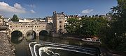
, Bath, and the South East Dorset conurbation
South East Dorset conurbation
The South east Dorset conurbation is a multi-centred conurbation on the south coast of Dorset in England. The area is rapidly becoming an amalgamation with the area of South West Hampshire immediately on the fringe of the newly formed New Forest National Park...
of Bournemouth
Bournemouth
Bournemouth is a large coastal resort town in the ceremonial county of Dorset, England. According to the 2001 Census the town has a population of 163,444, making it the largest settlement in Dorset. It is also the largest settlement between Southampton and Plymouth...
, Poole
Poole
Poole is a large coastal town and seaport in the county of Dorset, on the south coast of England. The town is east of Dorchester, and Bournemouth adjoins Poole to the east. The Borough of Poole was made a unitary authority in 1997, gaining administrative independence from Dorset County Council...
and Christchurch
Christchurch, Dorset
Christchurch is a borough and town in the county of Dorset on the south coast of England. The town adjoins Bournemouth in the west and the New Forest lies to the east. Historically in Hampshire, it joined Dorset with the reorganisation of local government in 1974 and is the most easterly borough in...
.
The region includes two National Parks
National parks of England and Wales
The national parks of England and Wales are areas of relatively undeveloped and scenic landscape that are designated under the National Parks and Access to the Countryside Act 1949...
and four World Heritage Sites, including Stonehenge
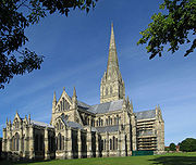
Stonehenge
Stonehenge is a prehistoric monument located in the English county of Wiltshire, about west of Amesbury and north of Salisbury. One of the most famous sites in the world, Stonehenge is composed of a circular setting of large standing stones set within earthworks...
.
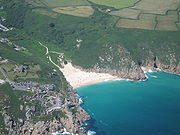
Traditionally, the South West of England has been well known for producing Cheddar cheese
Cheddar cheese
Cheddar cheese is a relatively hard, yellow to off-white, and sometimes sharp-tasting cheese, produced in several countries around the world. It has its origins in the English village of Cheddar in Somerset....
, which originated in the Somerset
Somerset
The ceremonial and non-metropolitan county of Somerset in South West England borders Bristol and Gloucestershire to the north, Wiltshire to the east, Dorset to the south-east, and Devon to the south-west. It is partly bounded to the north and west by the Bristol Channel and the estuary of the...
village of Cheddar
Cheddar
Cheddar is a large village and civil parish in the Sedgemoor district of the English county of Somerset. It is situated on the southern edge of the Mendip Hills, north-west of Wells. The civil parish includes the hamlets of Nyland and Bradley Cross...
, for Devon cream tea
Cream tea
A cream tea, Devonshire tea, Devon cream tea or Cornish cream tea is tea taken with a combination of scones, clotted cream, and jam....
s, Cornish pasties
Pasty
A pasty , sometimes known as a pastie or British pasty in the United States, is a filled pastry case, associated in particular with Cornwall in Great Britain. It is made by placing the uncooked filling on a flat pastry circle, and folding it to wrap the filling, crimping the edge at the side or top...
, and for cider
Cider
Cider or cyder is a fermented alcoholic beverage made from apple juice. Cider varies in alcohol content from 2% abv to 8.5% abv or more in traditional English ciders. In some regions, such as Germany and America, cider may be termed "apple wine"...
. It is also well known as the home of the Eden Project
Eden Project
The Eden Project is a visitor attraction in Cornwall in the United Kingdom, including the world's largest greenhouse. Inside the artificial biomes are plants that are collected from all around the world....
, Aardman Animations
Aardman Animations
Aardman Animations, Ltd., also known as Aardman Studios, or simply as Aardman, is a British animation studio based in Bristol, United Kingdom. The studio is known for films made using stop-motion clay animation techniques, particularly those featuring Plasticine characters Wallace and Gromit...
, the Glastonbury Festival
Glastonbury Festival
The Glastonbury Festival of Contemporary Performing Arts, commonly abbreviated to Glastonbury or even Glasto, is a performing arts festival that takes place near Pilton, Somerset, England, best known for its contemporary music, but also for dance, comedy, theatre, circus, cabaret and other arts.The...
, the Bristol International Balloon Fiesta
Bristol International Balloon Fiesta
The Bristol International Balloon Fiesta is held annually during August in Bristol, England. Teams from the UK and other parts of the world bring their hot air balloons to the site and participate in mass ascents where as many as 100 balloons may launch at a time.The event was first held in 1979...
, trip hop
Trip hop
Trip hop is a music genre consisting of downtempo electronic music which originated in the early 1990s in England, especially Bristol. Deriving from "post"-acid house, the term was first used by the British music media and press as a way to describe the more experimental variant of breakbeat which...
music and also Cornwall's surfing
Surfing
Surfing' is a surface water sport in which the surfer rides a surfboard on the crest and face of a wave which is carrying the surfer towards the shore...
beaches.
Key data and facts about the region are produced by the South West Observatory
South West Observatory
The South West Observatory is a regional resource for the South West of England, originally established by the South West Regional Development Agency , Government Office for the South West and the former South West Regional Assembly as a partnership for use by policy-makers to aide and improve...
.
Geography
Geology and landscape
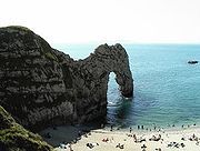
Most of the South West occupies a peninsulaPeninsula
A peninsula is a piece of land that is bordered by water on three sides but connected to mainland. In many Germanic and Celtic languages and also in Baltic, Slavic and Hungarian, peninsulas are called "half-islands"....
between the English Channel
English Channel
The English Channel , often referred to simply as the Channel, is an arm of the Atlantic Ocean that separates southern England from northern France, and joins the North Sea to the Atlantic. It is about long and varies in width from at its widest to in the Strait of Dover...
and Bristol Channel
Bristol Channel
The Bristol Channel is a major inlet in the island of Great Britain, separating South Wales from Devon and Somerset in South West England. It extends from the lower estuary of the River Severn to the North Atlantic Ocean...
. It has the longest coastline of England's regions, totalling 702 miles (1,130 km). Much of the coast is now protected from further substantial development because of its environmental importance, which contributes to the region’s attractiveness to tourists and residents.
Geologically the region is divided into the largely igneous
Igneous rock
Igneous rock is one of the three main rock types, the others being sedimentary and metamorphic rock. Igneous rock is formed through the cooling and solidification of magma or lava...
and metamorphic
Metamorphic rock
Metamorphic rock is the transformation of an existing rock type, the protolith, in a process called metamorphism, which means "change in form". The protolith is subjected to heat and pressure causing profound physical and/or chemical change...
west and sedimentary
Sedimentary rock
Sedimentary rock are types of rock that are formed by the deposition of material at the Earth's surface and within bodies of water. Sedimentation is the collective name for processes that cause mineral and/or organic particles to settle and accumulate or minerals to precipitate from a solution....
east, the dividing line slightly to the west of the River Exe
River Exe
The River Exe in England rises near the village of Simonsbath, on Exmoor in Somerset, near the Bristol Channel coast, but flows more or less directly due south, so that most of its length lies in Devon. It reaches the sea at a substantial ria, the Exe Estuary, on the south coast of Devon...
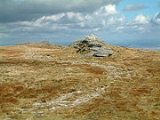
. Cornwall and West Devon's landscape is of rocky coastline and high moorland, notably at Bodmin Moor
Bodmin Moor
Bodmin Moor is a granite moorland in northeastern Cornwall, England, United Kingdom. It is in size, and originally dates from the Carboniferous period of geological history....
and Dartmoor
Dartmoor
Dartmoor is an area of moorland in south Devon, England. Protected by National Park status, it covers .The granite upland dates from the Carboniferous period of geological history. The moorland is capped with many exposed granite hilltops known as tors, providing habitats for Dartmoor wildlife. The...
National Park
National park
A national park is a reserve of natural, semi-natural, or developed land that a sovereign state declares or owns. Although individual nations designate their own national parks differently A national park is a reserve of natural, semi-natural, or developed land that a sovereign state declares or...
. These are due to the granite
Granite
Granite is a common and widely occurring type of intrusive, felsic, igneous rock. Granite usually has a medium- to coarse-grained texture. Occasionally some individual crystals are larger than the groundmass, in which case the texture is known as porphyritic. A granitic rock with a porphyritic...
and slate
Slate
Slate is a fine-grained, foliated, homogeneous metamorphic rock derived from an original shale-type sedimentary rock composed of clay or volcanic ash through low-grade regional metamorphism. The result is a foliated rock in which the foliation may not correspond to the original sedimentary layering...
that underlie the area. The highest point of the region is High Willhays
High Willhays
High Willhays or, according to some authors, High Willes is the highest point on Dartmoor, Devon, at 621 metres above sea level, and the highest point in Great Britain south of the Brecon Beacons.-Toponymy:...
, at 2039 feet (621 m), on Dartmoor
Dartmoor
Dartmoor is an area of moorland in south Devon, England. Protected by National Park status, it covers .The granite upland dates from the Carboniferous period of geological history. The moorland is capped with many exposed granite hilltops known as tors, providing habitats for Dartmoor wildlife. The...
. In North Devon the slates of the west and limestones of the east meet at Exmoor
Exmoor
Exmoor is an area of hilly open moorland in west Somerset and north Devon in South West England, named after the main river that flows out of the district, the River Exe. The moor has given its name to a National Park, which includes the Brendon Hills, the East Lyn Valley, the Vale of Porlock and ...
National Park. The variety of rocks of similar ages seen here have led to the county's name being lent to that of the Devonian
Devonian
The Devonian is a geologic period and system of the Paleozoic Era spanning from the end of the Silurian Period, about 416.0 ± 2.8 Mya , to the beginning of the Carboniferous Period, about 359.2 ± 2.5 Mya...
period.
The east of the region is characterised by wide, flat clay vale
Valley
In geology, a valley or dale is a depression with predominant extent in one direction. A very deep river valley may be called a canyon or gorge.The terms U-shaped and V-shaped are descriptive terms of geography to characterize the form of valleys...
s and chalk
Chalk
Chalk is a soft, white, porous sedimentary rock, a form of limestone composed of the mineral calcite. Calcite is calcium carbonate or CaCO3. It forms under reasonably deep marine conditions from the gradual accumulation of minute calcite plates shed from micro-organisms called coccolithophores....
and limestone
Limestone
Limestone is a sedimentary rock composed largely of the minerals calcite and aragonite, which are different crystal forms of calcium carbonate . Many limestones are composed from skeletal fragments of marine organisms such as coral or foraminifera....
downland
Downland
A downland is an area of open chalk hills. This term is especially used to describe the chalk countryside in southern England. Areas of downland are often referred to as Downs....
. The vales, with good irrigation, are home to the region's dairy agriculture. The Blackmore Vale
Blackmore Vale
The Blackmore Vale is a vale, or wide valley, in north Dorset, and to a lesser extent south Somerset and southwest Wiltshire in southern England. The vale is part of the Stour valley...
was Thomas Hardy
Thomas Hardy
Thomas Hardy, OM was an English novelist and poet. While his works typically belong to the Naturalism movement, several poems display elements of the previous Romantic and Enlightenment periods of literature, such as his fascination with the supernatural.While he regarded himself primarily as a...
's "Vale of the Little Dairies"; another, the Somerset Levels
Somerset Levels
The Somerset Levels, or the Somerset Levels and Moors as they are less commonly but more correctly known, is a sparsely populated coastal plain and wetland area of central Somerset, South West England, between the Quantock and Mendip Hills...
was created by reclaiming wetlands. The Southern England Chalk Formation
Southern England Chalk Formation
The Chalk Formation of Southern England is a system of chalk downland in the south of England. The formation is perhaps best known for Salisbury Plain, the location of Stonehenge, the Isle of Wight and the twin ridgeways of the North Downs and South Downs....
extends into the region, creating a series of high, sparsely populated and archaeologically rich downs, most famously Salisbury Plain
Salisbury Plain
Salisbury Plain is a chalk plateau in central southern England covering . It is part of the Southern England Chalk Formation and largely lies within the county of Wiltshire, with a little in Hampshire. The plain is famous for its rich archaeology, including Stonehenge, one of England's best known...
, but also Cranborne Chase
Cranborne Chase
Cranborne Chase is a Chalk plateau in central southern England, straddling the counties Dorset, Hampshire and Wiltshire. The plateau is part of the English Chalk Formation and is adjacent to Salisbury Plain and the West Wiltshire Downs in the north, the Dorset Downs to the south west and the...
, the Dorset Downs
Dorset Downs
The Dorset Downs are an area of Chalk downland in the centre of the county Dorset in south west England. The downs are the most western part of a larger Chalk Formation which also includes Cranborne Chase, Salisbury Plain, Hampshire Downs, Chiltern Hills, North Downs and South Downs.The Dorset...
and the Purbeck Hills
Purbeck Hills
The Purbeck Hills and South Dorset Downs are a ridge of chalk downs in Dorset, England. The hills extend from the Dorset Downs west of Dorchester, where the River Frome begins to form a valley dividing them from the larger area of downland to the north. The ridge then runs east through the Isle...
. These downs are the principal area of arable agriculture
Arable land
In geography and agriculture, arable land is land that can be used for growing crops. It includes all land under temporary crops , temporary meadows for mowing or pasture, land under market and kitchen gardens and land temporarily fallow...
in the region. Limestone is also found in the region, at the Cotswolds
Cotswolds
The Cotswolds are a range of hills in west-central England, sometimes called the Heart of England, an area across and long. The area has been designated as the Cotswold Area of Outstanding Natural Beauty...
, Quantock Hills
Quantock Hills
The Quantock Hills is a range of hills west of Bridgwater in Somerset, England. The Quantock Hills were England’s first Area of Outstanding Natural Beauty being designated in 1956 and consists of large amounts of heathland, oak woodlands, ancient parklands and agricultural land.The hills run from...
and Mendip Hills
Mendip Hills
The Mendip Hills is a range of limestone hills to the south of Bristol and Bath in Somerset, England. Running east to west between Weston-super-Mare and Frome, the hills overlook the Somerset Levels to the south and the Avon Valley to the north...
, where they support sheep farming. All of the principal rock types can be seen on the Jurassic Coast
Jurassic Coast
The Jurassic Coast is a World Heritage Site on the English Channel coast of southern England. The site stretches from Orcombe Point near Exmouth in East Devon to Old Harry Rocks near Swanage in East Dorset, a distance of ....
of Dorset and East Devon, where they document the entire Mesozoic
Mesozoic
The Mesozoic era is an interval of geological time from about 250 million years ago to about 65 million years ago. It is often referred to as the age of reptiles because reptiles, namely dinosaurs, were the dominant terrestrial and marine vertebrates of the time...
era from west to east.
Climate
The climate of South West England is classed as oceanicOceanic climate
An oceanic climate, also called marine west coast climate, maritime climate, Cascadian climate and British climate for Köppen climate classification Cfb and subtropical highland for Köppen Cfb or Cwb, is a type of climate typically found along the west coasts at the middle latitudes of some of the...
(Cfb) according to the Köppen climate classification
Köppen climate classification
The Köppen climate classification is one of the most widely used climate classification systems. It was first published by Crimea German climatologist Wladimir Köppen in 1884, with several later modifications by Köppen himself, notably in 1918 and 1936...
. The oceanic climate typically experiences cool winters with warmer summers and precipitation all year round, with more experienced in winter. Annual rainfall is about 1000 millimetres (39.4 in) and up to 2000 millimetres (78.7 in) on higher ground. Summer maxima averages range from 18 °C (64.4 °F) to 22 °C (71.6 °F) and winter minimum averages range from 1 °C (33.8 °F) to 4 °C (39.2 °F) across the south-west. It is the second windiest area of the United Kingdom, the majority of winds coming from the south-west and north-east. Government organisations predict the region to rise in temperature and become the hottest region in the United Kingdom.
Inland areas of low altitude experience the least amount of precipitation. They experience the highest summer maxima temperatures, but winter minima are colder than the coast. Snowfalls are more frequent in comparison to the coast, but less so in comparison to higher ground. It experiences the lowest wind speeds and sunshine total in between that of the coast and the moors. The climate of inland areas is more noticeable the further north-east into the region.
In comparison to inland areas, the coast experiences high minimum temperatures, especially in winter
Winter
Winter is the coldest season of the year in temperate climates, between autumn and spring. At the winter solstice, the days are shortest and the nights are longest, with days lengthening as the season progresses after the solstice.-Meteorology:...
, and it experiences slightly lower maximum temperatures during the summer. Rainfall is the lowest at the coast and snowfall is rarer than the rest of the region. Coastal areas are the windiest parts of the peninsula and they receive the most sunshine. The general coastal climate is more typical the further south-west into the region.
Areas of moorland
Moorland
Moorland or moor is a type of habitat, in the temperate grasslands, savannas, and shrublands biome, found in upland areas, characterised by low-growing vegetation on acidic soils and heavy fog...
inland such as: Bodmin Moor
Bodmin Moor
Bodmin Moor is a granite moorland in northeastern Cornwall, England, United Kingdom. It is in size, and originally dates from the Carboniferous period of geological history....
, Dartmoor
Dartmoor
Dartmoor is an area of moorland in south Devon, England. Protected by National Park status, it covers .The granite upland dates from the Carboniferous period of geological history. The moorland is capped with many exposed granite hilltops known as tors, providing habitats for Dartmoor wildlife. The...
and Exmoor
Exmoor
Exmoor is an area of hilly open moorland in west Somerset and north Devon in South West England, named after the main river that flows out of the district, the River Exe. The moor has given its name to a National Park, which includes the Brendon Hills, the East Lyn Valley, the Vale of Porlock and ...
experience lower temperatures and more precipitation than the rest of the south west (approximately twice as much rainfall as lowland areas), because of their high altitude. Both of these factors also cause it to experience the highest levels of snowfall and the lowest levels of sunshine. Exposed areas of the moors are windier than lowlands and can be almost as windy as the coast.
Regional identity
The boundaries of the South West Region are based upon those devised by central government in the 1930s for civil defence administration, and subsequently used for various statistical analyses. The region is also similar (subject to minor boundary adjustments) to that used in the 17th century Rule of the Major-GeneralsRule of the Major-Generals
The Rule of the Major-Generals from August 1655 – January 1657, was a period of direct military government during Oliver Cromwell's Protectorate.England was divided into 10 regions each governed by a Major-General who answered to the Lord Protector....
under Cromwell
Oliver Cromwell
Oliver Cromwell was an English military and political leader who overthrew the English monarchy and temporarily turned England into a republican Commonwealth, and served as Lord Protector of England, Scotland, and Ireland....
. (For further information, see Historical and alternative regions of England
Historical and alternative regions of England
England is divided into a number of different regional schemes for various purposes. Since the creation of the Government Office Regions in 1994 and their adoption for statistical purposes in 1999, some historical regional schemes have become obsolete...
). By the 1960s, the South West Region (including Dorset, which for some previous purposes had been included in a Southern region), was widely recognised for government administration and statistics. The boundaries were carried forward into the 1990s, when regional administrations were formally established as Government Office Regions. A regional assembly and regional development agency were added in 1999.
It has been argued that the official South West region does not possess a cultural and historic unity or identity of itself, which has led to criticism of it as an "artificial" construct. The large area of the region, stretching as it does from the Isles of Scilly to Gloucestershire, encompasses diverse areas which have little more in common with each other than they do with other areas of England. The region has several TV stations and newspapers based in different areas, and no single acknowledged regional "capital". Many people of the region have some level of a 'South West', or 'West Country' regional identity, although this may not necessarily correspond to an identification with the official government-defined region
Regions of England
In England, the region is the highest tier of sub-national division used by central Government. Between 1994 and 2011, the nine regions had an administrative role in the implementation of UK Government policy, and as the areas covered by elected bodies...
. It is however more common for people in the region to primarily identify at a national level (whether English
English nationalism
English nationalism refers to a nationalist outlook or political stance applied to England. In a general sense, it comprises political and social movements and sentiment inspired by a love for English culture, language and history, and a sense of pride in England and the English people...
, British
British nationalism
Far right politics in the United Kingdom have existed since at least the 1930s, with the formation of fascist and anti-semitic movements. It went on to acquire more explicitly racial connotations, being dominated in the 1960s and 1970s by self-proclaimed white nationalist organisations that oppose...
, Cornish, or other nations beyond the region itself), and/or a county or city level.
In particular, Cornwall
Cornwall
Cornwall is a unitary authority and ceremonial county of England, within the United Kingdom. It is bordered to the north and west by the Celtic Sea, to the south by the English Channel, and to the east by the county of Devon, over the River Tamar. Cornwall has a population of , and covers an area of...
's inclusion in the region is disputed by Cornish nationalists. The United Kingdom government has stated in the past that Cornwall is too small to become a region in its own right, having around one fifth of the population of the smallest existing English region. The cross-party Cornish Constitutional Convention
Cornish Constitutional Convention
The Cornish Constitutional Convention was formed in November 2000 with the objective of establishing a devolved Cornish Assembly . The Convention is a cross-party, cross-sector association with a strong consensus of support both in Cornwall and elsewhere...
and Cornish nationalist party Mebyon Kernow
Mebyon Kernow
Mebyon Kernow is a left-of-centre political party in Cornwall, United Kingdom. It primarily campaigns for devolution to Cornwall in the form of a Cornish Assembly, as well as social democracy and environmental protection.MK was formed as a pressure group in 1951, and contained as members activists...
have campaigned for a Cornish Assembly
Cornish Assembly
The Cornish Assembly is a proposed devolved regional assembly for Cornwall in the United Kingdom along the lines of the Scottish Parliament, National Assembly for Wales and Northern Ireland Assembly.-Overview:...
ever since the idea of regional devolution was put forward.
Settlements
Bristol
Bristol is a city, unitary authority area and ceremonial county in South West England, with an estimated population of 433,100 for the unitary authority in 2009, and a surrounding Larger Urban Zone with an estimated 1,070,000 residents in 2007...
, Plymouth
Plymouth
Plymouth is a city and unitary authority area on the coast of Devon, England, about south-west of London. It is built between the mouths of the rivers Plym to the east and Tamar to the west, where they join Plymouth Sound...
, Bournemouth
Bournemouth
Bournemouth is a large coastal resort town in the ceremonial county of Dorset, England. According to the 2001 Census the town has a population of 163,444, making it the largest settlement in Dorset. It is also the largest settlement between Southampton and Plymouth...
and Poole
Poole
Poole is a large coastal town and seaport in the county of Dorset, on the south coast of England. The town is east of Dorchester, and Bournemouth adjoins Poole to the east. The Borough of Poole was made a unitary authority in 1997, gaining administrative independence from Dorset County Council...
(collectively the South East Dorset conurbation
South East Dorset conurbation
The South east Dorset conurbation is a multi-centred conurbation on the south coast of Dorset in England. The area is rapidly becoming an amalgamation with the area of South West Hampshire immediately on the fringe of the newly formed New Forest National Park...
), Swindon
Swindon
Swindon is a large town within the borough of Swindon and ceremonial county of Wiltshire, in South West England. It is midway between Bristol, west and Reading, east. London is east...
, Gloucester
Gloucester
Gloucester is a city, district and county town of Gloucestershire in the South West region of England. Gloucester lies close to the Welsh border, and on the River Severn, approximately north-east of Bristol, and south-southwest of Birmingham....
, Cheltenham
Cheltenham
Cheltenham , also known as Cheltenham Spa, is a large spa town and borough in Gloucestershire, on the edge of the Cotswolds in the South-West region of England. It is the home of the flagship race of British steeplechase horse racing, the Gold Cup, the main event of the Cheltenham Festival held...
, Torbay
Torbay
Torbay is an east-facing bay and natural harbour, at the western most end of Lyme Bay in the south-west of England, situated roughly midway between the cities of Exeter and Plymouth. Part of the ceremonial county of Devon, Torbay was made a unitary authority on 1 April 1998...
, Exeter
Exeter
Exeter is a historic city in Devon, England. It lies within the ceremonial county of Devon, of which it is the county town as well as the home of Devon County Council. Currently the administrative area has the status of a non-metropolitan district, and is therefore under the administration of the...
, Bath, Weston-super-Mare
Weston-super-Mare
Weston-super-Mare is a seaside resort, town and civil parish in the unitary authority of North Somerset, which is within the ceremonial county of Somerset, England. It is located on the Bristol Channel coast, south west of Bristol, spanning the coast between the bounding high ground of Worlebury...
, Salisbury, Taunton
Taunton
Taunton is the county town of Somerset, England. The town, including its suburbs, had an estimated population of 61,400 in 2001. It is the largest town in the shire county of Somerset....
and Weymouth. The population of the South West is about five million.
Transport
The region lies on several main line railways. The Great Western Main LineGreat Western Main Line
The Great Western Main Line is a main line railway in Great Britain that runs westwards from London Paddington station to the west of England and South Wales. The core Great Western Main Line runs from London Paddington to Temple Meads railway station in Bristol. A major branch of the Great...
runs from London to Bristol, Exeter, Plymouth and Penzance
Penzance
Penzance is a town, civil parish, and port in Cornwall, England, in the United Kingdom. It is the most westerly major town in Cornwall and is approximately 75 miles west of Plymouth and 300 miles west-southwest of London...
in the far west of Cornwall. The South Western Main Line
South Western Main Line
The South Western Main Line is a railway line between London Waterloo and Weymouth on the Dorset coast, in the south of England. It is a major railway which serves many important commuter areas, as well as the major settlements of Southampton and Bournemouth...
runs from London and Southampton to Bournemouth, Poole and Weymouth in Dorset. The West of England Main Line
West of England Main Line
The West of England Main Line is a British railway line that runs from , Hampshire to Exeter St Davids in Devon, England. Passenger services run between London Waterloo station and Exeter...
runs from London to Exeter via south Wiltshire, north Dorset and south Somerset. The Wessex Main Line
Wessex Main Line
The Wessex Main Line is the railway line from Bristol Temple Meads to Southampton. Diverging from this route is the Heart of Wessex Line from Westbury to Weymouth.- Places served :The places served are listed below.*Bristol*Keynsham*Oldfield Park*Bath...
runs from Bristol to Salisbury and on to Southampton. The Heart of Wessex Line
Heart of Wessex Line
The Heart of Wessex Line, also known as the Bristol to Weymouth line, is a United Kingdom railway line that runs from Bristol to Westbury to Weymouth...
runs from Bristol
Bristol
Bristol is a city, unitary authority area and ceremonial county in South West England, with an estimated population of 433,100 for the unitary authority in 2009, and a surrounding Larger Urban Zone with an estimated 1,070,000 residents in 2007...
in the north of the region to Weymouth on the south Dorset
Dorset
Dorset , is a county in South West England on the English Channel coast. The county town is Dorchester which is situated in the south. The Hampshire towns of Bournemouth and Christchurch joined the county with the reorganisation of local government in 1974...
coast via Westbury
Westbury, Wiltshire
Westbury is a town and civil parish in the west of the English county of Wiltshire, most famous for the Westbury White Horse.-Name:The most likely origin of the West- in Westbury is simply that the town is near the western edge of the county of Wiltshire, the bounds of which have been much the same...
, Castle Cary
Castle Cary
Castle Cary is a market town and civil parish in south Somerset, England, north west of Wincanton and south of Shepton Mallet.The town is situated on the River Cary, a tributary of the Parrett.-History:...
and Yeovil
Yeovil
Yeovil is a town and civil parish in south Somerset, England. The parish had a population of 27,949 at the 2001 census, although the wider urban area had a population of 42,140...
, with most services starting at Gloucester
Gloucester
Gloucester is a city, district and county town of Gloucestershire in the South West region of England. Gloucester lies close to the Welsh border, and on the River Severn, approximately north-east of Bristol, and south-southwest of Birmingham....
.
Three major roads enter the region from the east. The M4 motorway
M4 motorway
The M4 motorway links London with South Wales. It is part of the unsigned European route E30. Other major places directly accessible from M4 junctions are Reading, Swindon, Bristol, Newport, Cardiff and Swansea...
from London to South Wales via Bristol is the busiest. The A303
A303 road
The A303 is a 92-mile long trunk road in England. It is the main road between Basingstoke in Hampshire and Honiton in Devon. The M3, the A303 and the A30 together make up one of the main routes from London to South West England, running from London to Land's End in Cornwall...
cuts through the centre of the region from Salisbury to Honiton
Honiton
Honiton is a town and civil parish in East Devon, situated close to the River Otter, north east of Exeter in the county of Devon. The town's name is pronounced in two ways, and , each pronunciation having its adherents...
, where it merges with the A30
A30 road
The 284 miles A30 road from London to Land's End, historically known as the Great South West Road used to provide the most direct route from London to the south west; more recently the M3 motorway and A303 road performs this function for much of the route and only parts of A30 now retain trunk...
to continue past Exeter to the west of Cornwall. The A31
A31 road
The A31 is a major trunk road in southern England that runs from Guildford in Surrey to Bere Regis in Dorset.-Route of road:The road begins in the centre of Guildford, meeting the A3 road before running south west along the Hog's Back. It continues past Farnham, Alton and New Alresford before...
, an extension of the M27
M27 motorway
The M27 is a motorway in Hampshire, England. It is long and runs west-east from Cadnam to Portsmouth. It was opened in stages between 1975 and 1983. It is however unfinished as an extension to the east was planned...
, serves Poole and Bournemouth and the Dorset coast. The M5
M5 motorway
The M5 is a motorway in England. It runs from a junction with the M6 at West Bromwich near Birmingham to Exeter in Devon. Heading south-west, the M5 runs east of West Bromwich and west of Birmingham through Sandwell Valley...
runs from the West Midlands
West Midlands (region)
The West Midlands is an official region of England, covering the western half of the area traditionally known as the Midlands. It contains the second most populous British city, Birmingham, and the larger West Midlands conurbation, which includes the city of Wolverhampton and large towns of Dudley,...
through Gloucestershire, Bristol and Somerset to Exeter. The A38
A38 road
The A38, part of which is also known as the Devon Expressway, is a major A-class trunk road in England.The road runs from Bodmin in Cornwall to Mansfield in Nottinghamshire. It is long, making it one of the longest A-roads in England. It was formerly known as the Leeds — Exeter Trunk Road,...
serves as a western extension to Plymouth. There are three other smaller motorways in the region, all in the Bristol area
Transport in Bristol
Bristol is a city in south west England, situated near the Bristol Channel coast, approximately 115 miles west of London. Several factors have influenced the development of its transport network. It is a major centre of employment, retail, culture and higher education, has many historic areas,...
.
Passenger airports in the region include Bristol
Bristol Airport
Bristol Airport may refer to:* Bristol Airport, serving Bristol, England, United Kingdom ** Bristol Airport , a docu-soap based on events at Bristol Airport...
, Exeter
Exeter International Airport
Exeter International Airport is an airport located at Clyst Honiton in the District of East Devon close to the city of Exeter and within the county of Devon, South West England....
, Plymouth
Plymouth City Airport
Plymouth City Airport is an airport located within the City of Plymouth north northeast of the city centre in Devon, England. The airport opened on this site in 1925 and was officially opened by the Edward VIII, as Prince of Wales, in 1931...
, Newquay and Bournemouth
Bournemouth Airport
Bournemouth Airport is an airport located north-northeast of Bournemouth, in southern England...
.
Within the region the local transport authorities carry out transport planning through the use of a Local Transport Plan (LTP)
Local Transport Plan
Local transport plans, divided into full local transport plans and local implementation plans for transport are an important part of transport planning in England...
which outlines their strategies, policies and implementation programme. The most recent LTP is that for the period 2006-11. In the South West region the following transport authorities have published their LTP online: Bournemouth
Bournemouth
Bournemouth is a large coastal resort town in the ceremonial county of Dorset, England. According to the 2001 Census the town has a population of 163,444, making it the largest settlement in Dorset. It is also the largest settlement between Southampton and Plymouth...
U.A., Cornwall
Cornwall
Cornwall is a unitary authority and ceremonial county of England, within the United Kingdom. It is bordered to the north and west by the Celtic Sea, to the south by the English Channel, and to the east by the county of Devon, over the River Tamar. Cornwall has a population of , and covers an area of...
U.A., Devon
Devon
Devon is a large county in southwestern England. The county is sometimes referred to as Devonshire, although the term is rarely used inside the county itself as the county has never been officially "shired", it often indicates a traditional or historical context.The county shares borders with...
, Dorset
Dorset
Dorset , is a county in South West England on the English Channel coast. The county town is Dorchester which is situated in the south. The Hampshire towns of Bournemouth and Christchurch joined the county with the reorganisation of local government in 1974...
, Gloucestershire
Gloucestershire
Gloucestershire is a county in South West England. The county comprises part of the Cotswold Hills, part of the flat fertile valley of the River Severn, and the entire Forest of Dean....
, Plymouth
Plymouth
Plymouth is a city and unitary authority area on the coast of Devon, England, about south-west of London. It is built between the mouths of the rivers Plym to the east and Tamar to the west, where they join Plymouth Sound...
U.A., Somerset
Somerset
The ceremonial and non-metropolitan county of Somerset in South West England borders Bristol and Gloucestershire to the north, Wiltshire to the east, Dorset to the south-east, and Devon to the south-west. It is partly bounded to the north and west by the Bristol Channel and the estuary of the...
, Swindon
Swindon
Swindon is a large town within the borough of Swindon and ceremonial county of Wiltshire, in South West England. It is midway between Bristol, west and Reading, east. London is east...
U. A., Torbay
Torbay
Torbay is an east-facing bay and natural harbour, at the western most end of Lyme Bay in the south-west of England, situated roughly midway between the cities of Exeter and Plymouth. Part of the ceremonial county of Devon, Torbay was made a unitary authority on 1 April 1998...
U. A. and Wiltshire unitary authority
Wiltshire Council
Wiltshire Council is the unitary authority for most of the county of Wiltshire, in the West of England, the successor authority to Wiltshire County Council and to four districts—Kennet, North Wiltshire, Salisbury, and West Wiltshire—all of which had been created in 1973 and were...
. The transport authorities of Bath and North East Somerset
Bath and North East Somerset
Bath and North East Somerset is a unitary authority that was created on 1 April 1996 following the abolition of the County of Avon. It is part of the Ceremonial county of Somerset...
U. A., Bristol
Bristol
Bristol is a city, unitary authority area and ceremonial county in South West England, with an estimated population of 433,100 for the unitary authority in 2009, and a surrounding Larger Urban Zone with an estimated 1,070,000 residents in 2007...
U. A., North Somerset
North Somerset
North Somerset is a unitary authority in England. Its area covers part of the ceremonial county of Somerset but it is administered independently of the non-metropolitan county. Its administrative headquarters is in the town hall in Weston-super-Mare....
U. A. and South Gloucestershire
South Gloucestershire
South Gloucestershire is a unitary district in the ceremonial county of Gloucestershire, in South West England.-History:The district was created in 1996, when the county of Avon was abolished, by the merger of former area of the districts of Kingswood and Northavon...
U. A. publish a single Joint Local Transport Plan as part of the West of England Partnership
West of England
The West of England is a loose and locationally unspecific term sometimes given to the area surrounding the city and county of Bristol, England, and also sometimes applied more widely and in other parts of South West England.-Use in the Bristol area:...
.
Pre-Roman
There is evidenceEvidence
Evidence in its broadest sense includes everything that is used to determine or demonstrate the truth of an assertion. Giving or procuring evidence is the process of using those things that are either presumed to be true, or were themselves proven via evidence, to demonstrate an assertion's truth...
from flint
Flint
Flint is a hard, sedimentary cryptocrystalline form of the mineral quartz, categorized as a variety of chert. It occurs chiefly as nodules and masses in sedimentary rocks, such as chalks and limestones. Inside the nodule, flint is usually dark grey, black, green, white, or brown in colour, and...
artefacts
Artifact (archaeology)
An artifact or artefact is "something made or given shape by man, such as a tool or a work of art, esp an object of archaeological interest"...
in a quarry at Westbury
Westbury-sub-Mendip
Westbury-sub-Mendip is a village in Somerset, England, with a population of about 800, situated on the southern slopes of the Mendip Hills from Wells and Cheddar.The parish boundary is formed by the River Axe-History:...
that an ancestor
Ancestor
An ancestor is a parent or the parent of an ancestor ....
of modern man, possibly Homo heidelbergensis
Homo heidelbergensis
Homo heidelbergensis is an extinct species of the genus Homo which may be the direct ancestor of both Homo neanderthalensis in Europe and Homo sapiens. The best evidence found for these hominins date between 600,000 and 400,000 years ago. H...
, was present in the future Somerset from around 500,000 years ago. There is some evidence of human occupation of southern England before the last ice age
Ice age
An ice age or, more precisely, glacial age, is a generic geological period of long-term reduction in the temperature of the Earth's surface and atmosphere, resulting in the presence or expansion of continental ice sheets, polar ice sheets and alpine glaciers...
, such as Kents Cavern in Devon, but largely in the south east
South East England
South East England is one of the nine official regions of England, designated in 1994 and adopted for statistical purposes in 1999. It consists of Berkshire, Buckinghamshire, East Sussex, Hampshire, Isle of Wight, Kent, Oxfordshire, Surrey and West Sussex...
. The British mainland was connected to the continent during the ice age and humans may have repeatedly migrated into and out of the region as the climate fluctuated. There is evidence of human habitation in the caves at Cheddar Gorge 10,000–11,000 years BC, during a partial thaw in the ice age. The earliest scientifically dated cemetery
Cemetery
A cemetery is a place in which dead bodies and cremated remains are buried. The term "cemetery" implies that the land is specifically designated as a burying ground. Cemeteries in the Western world are where the final ceremonies of death are observed...
in Britain
Great Britain
Great Britain or Britain is an island situated to the northwest of Continental Europe. It is the ninth largest island in the world, and the largest European island, as well as the largest of the British Isles...
was found at Aveline's Hole
Aveline's Hole
Aveline's Hole is a cave at Burrington Combe in the limestone of the Mendip Hills, in Somerset, England.The earliest scientifically dated cemetery in Britain was found at Aveline's Hole...
in the Mendip Hills
Mendip Hills
The Mendip Hills is a range of limestone hills to the south of Bristol and Bath in Somerset, England. Running east to west between Weston-super-Mare and Frome, the hills overlook the Somerset Levels to the south and the Avon Valley to the north...
. The human bone fragments it contained, from about 21 different individuals, are thought to be between roughly 10,200 and 10,400 years old. During this time the tundra gave way to birch
Birch
Birch is a tree or shrub of the genus Betula , in the family Betulaceae, closely related to the beech/oak family, Fagaceae. The Betula genus contains 30–60 known taxa...
forest
Forest
A forest, also referred to as a wood or the woods, is an area with a high density of trees. As with cities, depending where you are in the world, what is considered a forest may vary significantly in size and have various classification according to how and what of the forest is composed...
s and grassland
Grassland
Grasslands are areas where the vegetation is dominated by grasses and other herbaceous plants . However, sedge and rush families can also be found. Grasslands occur naturally on all continents except Antarctica...
and evidence for human settlement appears at Salisbury Plain
Salisbury Plain
Salisbury Plain is a chalk plateau in central southern England covering . It is part of the Southern England Chalk Formation and largely lies within the county of Wiltshire, with a little in Hampshire. The plain is famous for its rich archaeology, including Stonehenge, one of England's best known...
, Wiltshire and Hengistbury Head
Hengistbury Head
Hengistbury Head is a headland jutting into the English Channel between Bournemouth and Milford on Sea in the English county of Dorset.At the end is a spit which creates the narrow entrance to Christchurch Harbour.-Location:...
, Dorset.
At the end of the last Ice Age the Bristol Channel
Bristol Channel
The Bristol Channel is a major inlet in the island of Great Britain, separating South Wales from Devon and Somerset in South West England. It extends from the lower estuary of the River Severn to the North Atlantic Ocean...
was dry land but subsequently the sea level rose, resulting in major coastal changes. The Somerset Levels
Somerset Levels
The Somerset Levels, or the Somerset Levels and Moors as they are less commonly but more correctly known, is a sparsely populated coastal plain and wetland area of central Somerset, South West England, between the Quantock and Mendip Hills...
became flooded, but the dry point
Dry point
In geography a dry point is an area of firm or flood-free ground in an area of wetland, marsh or flood plains. The term typically applies to settlements, and dry point settlements were common in history....
s such as Glastonbury
Glastonbury
Glastonbury is a small town in Somerset, England, situated at a dry point on the low lying Somerset Levels, south of Bristol. The town, which is in the Mendip district, had a population of 8,784 in the 2001 census...
and Brent Knoll
Brent Knoll
Brent Knoll is a village in Somerset, England, which lies on the southern edge of Brent Knoll – a hill with a height of 137 metres that dominates the low surrounding landscape of the Somerset Levels.-History:...
are known to have been occupied by Mesolithic
Mesolithic
The Mesolithic is an archaeological concept used to refer to certain groups of archaeological cultures defined as falling between the Paleolithic and the Neolithic....
hunters. The landscape at this time was tundra
Tundra
In physical geography, tundra is a biome where the tree growth is hindered by low temperatures and short growing seasons. The term tundra comes through Russian тундра from the Kildin Sami word tūndâr "uplands," "treeless mountain tract." There are three types of tundra: Arctic tundra, alpine...
. Britain's oldest complete skeleton, Cheddar Man
Cheddar Man
Cheddar Man is the name given to the remains of a human male found in Gough's Cave in Cheddar Gorge, Somerset, England. The remains date to approximately 7150 BC, and it appears that he died a violent death. It is Britain’s oldest complete human skeleton....
, lived at Cheddar Gorge around 7150 BC (the Upper Palaeolithic or Old Stone Age), shortly after the end of the ice age; however it is unclear whether the region was continually inhabited during the previous 4,000 years, or if humans returned to the gorge after a final cold spell. A Palaeolithic flint tool found in West Sedgemoor is the earliest indication of human presence on the Somerset Levels. During the 7th millennium BC the sea level rose and flooded the valleys so the Mesolithic
Mesolithic
The Mesolithic is an archaeological concept used to refer to certain groups of archaeological cultures defined as falling between the Paleolithic and the Neolithic....
people occupied seasonal camps on the higher ground, indicated by scatters of flints. The Neolithic
Neolithic
The Neolithic Age, Era, or Period, or New Stone Age, was a period in the development of human technology, beginning about 9500 BC in some parts of the Middle East, and later in other parts of the world. It is traditionally considered as the last part of the Stone Age...
people continued to exploit the reedswamps for their natural resources and started to construct wooden track ways. These included the Post Track
Post Track
The Post Track is an ancient causeway in the Somerset Levels, England. It dates from around 3838 BC, making it some 30 years older than the Sweet Track from the same area. It was constructed of long ash planks, with lime and hazel posts spaced along 3-metre intervals...
and the Sweet Track
Sweet Track
The Sweet Track is an ancient causeway in the Somerset Levels, England. It was built in 3807 or 3806 BC and has been claimed to be the oldest road in the world. It was the oldest timber trackway discovered in Northern Europe until the 2009 discovery of a 6,000 year-old trackway in Belmarsh Prison...
. The Sweet Track, dating from the 3800s BC
39th century BC
-Events:* The Post Track, an ancient causeway in the Somerset Levels, England, is built, ca. 3838 BC. It is one of the oldest engineered roads discovered in Northern Europe....
, is the world's oldest timber trackway
Timber trackway
A timber trackway was typically used as the shortest route between two places in a bog or peatland and have been built for thousands of years as a means of getting between two points. Timber trackways have been identified in archaeological finds in Neolithic England, dating to 500 years before...
and was once thought to be the world's oldest engineered road
Road
A road is a thoroughfare, route, or way on land between two places, which typically has been paved or otherwise improved to allow travel by some conveyance, including a horse, cart, or motor vehicle. Roads consist of one, or sometimes two, roadways each with one or more lanes and also any...
way. The Levels were also the location of the Glastonbury Lake Village
Glastonbury Lake Village
Glastonbury Lake Village was an iron age village on the Somerset Levels near Godney, some north west of Glastonbury, Somerset, England. It has been designated as a Scheduled Ancient Monument and covers an area of north to south by east to west....
as well as two at Meare
Meare
Meare is a village and civil parish north west of Glastonbury on the Somerset Levels, in the Mendip district of Somerset, England. The parish includes the village of Westhay.-History:...
. Stonehenge
Stonehenge
Stonehenge is a prehistoric monument located in the English county of Wiltshire, about west of Amesbury and north of Salisbury. One of the most famous sites in the world, Stonehenge is composed of a circular setting of large standing stones set within earthworks...
and Avebury
Avebury
Avebury is a Neolithic henge monument containing three stone circles which is located around the village of Avebury in Wiltshire, south west England. Unique amongst megalithic monuments, Avebury contains the largest stone circle in Europe, and is one of the best known prehistoric sites in Britain...
are perhaps the most famous Neolithic sites in the UK.
The region was heavily populated during the Neolithic, Bronze Age
Bronze Age
The Bronze Age is a period characterized by the use of copper and its alloy bronze as the chief hard materials in the manufacture of some implements and weapons. Chronologically, it stands between the Stone Age and Iron Age...
and Iron Age
Iron Age
The Iron Age is the archaeological period generally occurring after the Bronze Age, marked by the prevalent use of iron. The early period of the age is characterized by the widespread use of iron or steel. The adoption of such material coincided with other changes in society, including differing...
periods. Many monuments, barrows and trackways exist. Coin evidence shows that the region was split between the Durotriges
Durotriges
The Durotriges were one of the Celtic tribes living in Britain prior to the Roman invasion. The tribe lived in modern Dorset, south Wiltshire and south Somerset...
, Dobunni
Dobunni
The Dobunni were one of the Celtic tribes living in the British Isles prior to the Roman invasion of Britain. There are seven known references to the tribe in Roman histories and inscriptions. The latter part of the name possibly derives from Bune, a cup or vessel...
and Dumnonii
Dumnonii
The Dumnonii or Dumnones were a British Celtic tribe who inhabited Dumnonia, the area now known as Devon and Cornwall in the farther parts of the South West peninsula of Britain, from at least the Iron Age up to the early Saxon period...
. The Iron Age tribe in Dorset were the Durotriges, "water dwellers", whose main settlement is represented by Maiden Castle
Maiden Castle, Dorset
Maiden Castle is an Iron Age hill fort south west of Dorchester, in the English county of Dorset. Hill forts were fortified hill-top settlements constructed across Britain during the Iron Age...
. Ptolemy
Ptolemy
Claudius Ptolemy , was a Roman citizen of Egypt who wrote in Greek. He was a mathematician, astronomer, geographer, astrologer, and poet of a single epigram in the Greek Anthology. He lived in Egypt under Roman rule, and is believed to have been born in the town of Ptolemais Hermiou in the...
stated that Bath was in the territory of the Belgae
Belgae
The Belgae were a group of tribes living in northern Gaul, on the west bank of the Rhine, in the 3rd century BC, and later also in Britain, and possibly even Ireland...
, but this may be a mistake. The Celtic gods were worshipped at the temple
Temple
A temple is a structure reserved for religious or spiritual activities, such as prayer and sacrifice, or analogous rites. A templum constituted a sacred precinct as defined by a priest, or augur. It has the same root as the word "template," a plan in preparation of the building that was marked out...
of Sulis
Sulis
In localised Celtic polytheism practised in Britain, Sulis was a deity worshipped at the thermal spring of Bath . She was worshipped by the Romano-British as Sulis Minerva, whose votive objects and inscribed lead tablets suggest that she was conceived of both as a nourishing, life-giving mother...
at Bath and possibly the temple on Brean Down
Brean Down
Brean Down is a promontory off the coast of Somerset standing high and extending into the Bristol Channel at the eastern end of Bridgwater Bay between Weston-super-Mare and Burnham-on-Sea....
. Iron Age sites on the Quantock Hills
Quantock Hills
The Quantock Hills is a range of hills west of Bridgwater in Somerset, England. The Quantock Hills were England’s first Area of Outstanding Natural Beauty being designated in 1956 and consists of large amounts of heathland, oak woodlands, ancient parklands and agricultural land.The hills run from...
, include major hill fort
Hill fort
A hill fort is a type of earthworks used as a fortified refuge or defended settlement, located to exploit a rise in elevation for defensive advantage. They are typically European and of the Bronze and Iron Ages. Some were used in the post-Roman period...
s at Dowsborough
Dowsborough
Dowsborough Camp is an Iron Age hill fort on the Quantock Hills near Nether Stowey in Somerset, England. It has been designated as a Scheduled Ancient Monument .-Background:...
and Ruborough, as well as smaller earthwork enclosures, such as Trendle Ring
Trendle Ring
Trendle Ring is an Iron Age earthwork on the Quantock Hills near Bicknoller in Somerset, England. It is a Scheduled Ancient Monument .The word trendle means circle, so it is a tautological place name....
, Elworthy Barrows
Elworthy Barrows
Elworthy Barrows is an unfinished Iron Age hill fort rather than Bronze Age barrows, which has been designated as a Scheduled Ancient Monument . It is located in the civil parish of Brompton Ralph near Wiveliscombe, Somerset, England.-Background:...
and Plainsfield Camp
Plainsfield Camp
Plainsfield Camp is a possible Iron Age earthwork on the Quantock Hills near Aisholt in Somerset, England.The so-called hill fort has several features that make it more likely to be an animal enclosure, than a defended settlement:...
.
At the time of the Roman invasion, the inhabitants of the entire area that would later be included in the region spoke a Brythonic Celtic
Brythonic languages
The Brythonic or Brittonic languages form one of the two branches of the Insular Celtic language family, the other being Goidelic. The name Brythonic was derived by Welsh Celticist John Rhys from the Welsh word Brython, meaning an indigenous Briton as opposed to an Anglo-Saxon or Gael...
language. Languages descendant from that language are still spoken in Cornwall
Cornwall
Cornwall is a unitary authority and ceremonial county of England, within the United Kingdom. It is bordered to the north and west by the Celtic Sea, to the south by the English Channel, and to the east by the county of Devon, over the River Tamar. Cornwall has a population of , and covers an area of...
, Wales
Wales
Wales is a country that is part of the United Kingdom and the island of Great Britain, bordered by England to its east and the Atlantic Ocean and Irish Sea to its west. It has a population of three million, and a total area of 20,779 km²...
, and Brittany
Brittany
Brittany is a cultural and administrative region in the north-west of France. Previously a kingdom and then a duchy, Brittany was united to the Kingdom of France in 1532 as a province. Brittany has also been referred to as Less, Lesser or Little Britain...
.
Roman period
During the Roman eraRoman Britain
Roman Britain was the part of the island of Great Britain controlled by the Roman Empire from AD 43 until ca. AD 410.The Romans referred to the imperial province as Britannia, which eventually comprised all of the island of Great Britain south of the fluid frontier with Caledonia...
, the east of the region, particularly in the Cotswolds and eastern Somerset, was heavily Romanised but was much less so in Devon and Cornwall, though Exeter was a regional capital. Villas, farms and temples relating to the period exist in the region, including the remains at Bath.
The area now comprising the county of Somerset
Somerset
The ceremonial and non-metropolitan county of Somerset in South West England borders Bristol and Gloucestershire to the north, Wiltshire to the east, Dorset to the south-east, and Devon to the south-west. It is partly bounded to the north and west by the Bristol Channel and the estuary of the...
was part of the Roman Empire
Roman Empire
The Roman Empire was the post-Republican period of the ancient Roman civilization, characterised by an autocratic form of government and large territorial holdings in Europe and around the Mediterranean....
from 47 AD to about 409 AD. However, the end was not abrupt and elements of Romanitas
Romanitas
Romanità also termed Romanitas in English referring to "Roman-ness" or the Roman ideal the refers to an immiscibly Latin culture of the Roman Empire. Cicero contributed much to the notion....
lingered on for perhaps a century. Somerset was invaded from the south-east by the Second Legion
Legio II Augusta
Legio secunda Augusta , was a Roman legion, levied by Gaius Vibius Pansa Caetronianus in 43 BC, and still operative in Britannia in the 4th century...
Augusta, under the future emperor Vespasian
Vespasian
Vespasian , was Roman Emperor from 69 AD to 79 AD. Vespasian was the founder of the Flavian dynasty, which ruled the Empire for a quarter century. Vespasian was descended from a family of equestrians, who rose into the senatorial rank under the Emperors of the Julio-Claudian dynasty...
. The hillforts of the Durotriges
Durotriges
The Durotriges were one of the Celtic tribes living in Britain prior to the Roman invasion. The tribe lived in modern Dorset, south Wiltshire and south Somerset...
at Ham Hill
Ham Hill Country Park
Ham Hill is a geological Site of Special Scientific Interest , Scheduled Ancient Monument, Iron Age hill fort, Roman site, Local Nature Reserve and country park, to the west of Yeovil in Somerset, England....
and Cadbury Castle
Cadbury Castle, Somerset
Cadbury Castle is an Iron Age hill fort in the civil parish of South Cadbury in the English county of Somerset. It is a Scheduled Ancient Monument and associated with King Arthur.-Background:...
were captured. Ham Hill probably had a temporary Roman occupation. The massacre at Cadbury Castle
Cadbury Castle, Somerset
Cadbury Castle is an Iron Age hill fort in the civil parish of South Cadbury in the English county of Somerset. It is a Scheduled Ancient Monument and associated with King Arthur.-Background:...
seems to have been associated with the later Boudiccan Revolt of 60-61 AD. The area remained part of the Roman Empire
Roman Empire
The Roman Empire was the post-Republican period of the ancient Roman civilization, characterised by an autocratic form of government and large territorial holdings in Europe and around the Mediterranean....
until around 409 AD.
Mendip Hills
The Mendip Hills is a range of limestone hills to the south of Bristol and Bath in Somerset, England. Running east to west between Weston-super-Mare and Frome, the hills overlook the Somerset Levels to the south and the Avon Valley to the north...
. A great deal of the attraction of the lead mines may have been the potential for the extraction of silver
Silver
Silver is a metallic chemical element with the chemical symbol Ag and atomic number 47. A soft, white, lustrous transition metal, it has the highest electrical conductivity of any element and the highest thermal conductivity of any metal...
. Forts were set up at Bath and Ilchester
Ilchester
Ilchester is a village and civil parish, situated on the River Yeo or Ivel, five miles north of Yeovil, in the English county of Somerset. The parish, which includes the village of Sock Dennis and the old parish of Northover, has a population of 2,021...
. The lead and silver mines
Mining
Mining is the extraction of valuable minerals or other geological materials from the earth, from an ore body, vein or seam. The term also includes the removal of soil. Materials recovered by mining include base metals, precious metals, iron, uranium, coal, diamonds, limestone, oil shale, rock...
at Charterhouse
Charterhouse Roman Town
Charterhouse Roman Town was a town in the Roman province of Britannia. Its site is located just to the west of the village of Charterhouse-on-Mendip in the English county of Somerset....
in the Mendip Hills
Mendip Hills
The Mendip Hills is a range of limestone hills to the south of Bristol and Bath in Somerset, England. Running east to west between Weston-super-Mare and Frome, the hills overlook the Somerset Levels to the south and the Avon Valley to the north...
were run by the military
Military
A military is an organization authorized by its greater society to use lethal force, usually including use of weapons, in defending its country by combating actual or perceived threats. The military may have additional functions of use to its greater society, such as advancing a political agenda e.g...
. The Romans established a defensive boundary along the new military road known the Fosse Way
Fosse Way
The Fosse Way was a Roman road in England that linked Exeter in South West England to Lincoln in Lincolnshire, via Ilchester , Bath , Cirencester and Leicester .It joined Akeman Street and Ermin Way at Cirencester, crossed Watling Street at Venonis south...
(from the Latin
Latin
Latin is an Italic language originally spoken in Latium and Ancient Rome. It, along with most European languages, is a descendant of the ancient Proto-Indo-European language. Although it is considered a dead language, a number of scholars and members of the Christian clergy speak it fluently, and...
fossa meaning ditch). The Fosse Way ran through Bath, Shepton Mallet
Shepton Mallet
Shepton Mallet is a small rural town and civil parish in the Mendip district of Somerset in South West England. Situated approximately south of Bristol and east of Wells, the town is estimated to have a population of 9,700. It contains the administrative headquarters of Mendip District Council...
, Ilchester
Ilchester
Ilchester is a village and civil parish, situated on the River Yeo or Ivel, five miles north of Yeovil, in the English county of Somerset. The parish, which includes the village of Sock Dennis and the old parish of Northover, has a population of 2,021...
and south-west towards Axminster
Axminster
Axminster is a market town and civil parish on the eastern border of Devon in England. The town is built on a hill overlooking the River Axe which heads towards the English Channel at Axmouth, and is in the East Devon local government district. It has a population of 5,626. The market is still...
. The road from Dorchester ran through Yeovil
Yeovil
Yeovil is a town and civil parish in south Somerset, England. The parish had a population of 27,949 at the 2001 census, although the wider urban area had a population of 42,140...
to meet the Fosse Way at Ilchester
Ilchester
Ilchester is a village and civil parish, situated on the River Yeo or Ivel, five miles north of Yeovil, in the English county of Somerset. The parish, which includes the village of Sock Dennis and the old parish of Northover, has a population of 2,021...
. There was salt
Salt
In chemistry, salts are ionic compounds that result from the neutralization reaction of an acid and a base. They are composed of cations and anions so that the product is electrically neutral...
production on the Somerset Levels
Somerset Levels
The Somerset Levels, or the Somerset Levels and Moors as they are less commonly but more correctly known, is a sparsely populated coastal plain and wetland area of central Somerset, South West England, between the Quantock and Mendip Hills...
near Highbridge
Highbridge, Somerset
Highbridge is a small market town situated on the edge of the Somerset Levels near the mouth of the River Brue. It is in the County of Somerset, and is approximately north west of Taunton, the county town of Somerset. Highbridge is in the District of Sedgemoor, being situated approximately north...
and quarry
Quarry
A quarry is a type of open-pit mine from which rock or minerals are extracted. Quarries are generally used for extracting building materials, such as dimension stone, construction aggregate, riprap, sand, and gravel. They are often collocated with concrete and asphalt plants due to the requirement...
ing took place near Bath, where the Roman Baths gave their name to Bath.
Excavations carried out before the flood
Flood
A flood is an overflow of an expanse of water that submerges land. The EU Floods directive defines a flood as a temporary covering by water of land not normally covered by water...
ing of Chew Valley Lake
Chew Valley Lake
Chew Valley Lake is a large reservoir in the Chew Valley, Somerset, England, and the fifth-largest artificial lake in the United Kingdom , with an area of 1,200 acres...
also uncovered Roman remains, indicating agricultural and industrial activity from the second half of the 1st century until the 3rd century AD. The finds included a moderately large villa
Roman villa
A Roman villa is a villa that was built or lived in during the Roman republic and the Roman Empire. A villa was originally a Roman country house built for the upper class...
at Chew Park, where wooden writing tablets (the first in the UK) with ink writing were found. There is also evidence from the Pagans Hill Roman Temple
Pagans Hill Roman Temple
The Pagans Hill Roman Temple was a Romano-British-style temple excavated on Pagans Hill at Chew Stoke in the English county of Somerset.-Excavations:...
at Chew Stoke
Chew Stoke
Chew Stoke is a small village and civil parish in the Chew Valley, in Somerset, England, about south of Bristol. It is at the northern edge of the Mendip Hills, a region designated by the United Kingdom as an Area of Outstanding Natural Beauty, and is within the Bristol/Bath green belt...
. In October 2001 the West Bagborough Hoard
West Bagborough Hoard
The West Bagborough Hoard is a hoard of 670 Roman coins and 72 pieces of hacksilver found in October 2001 by metal detectorist James Hawkesworth near West Bagborough in Somerset, England.-Discovery, excavation and valuation:...
of 4th century Roman
Ancient Rome
Ancient Rome was a thriving civilization that grew on the Italian Peninsula as early as the 8th century BC. Located along the Mediterranean Sea and centered on the city of Rome, it expanded to one of the largest empires in the ancient world....
silver
Silver
Silver is a metallic chemical element with the chemical symbol Ag and atomic number 47. A soft, white, lustrous transition metal, it has the highest electrical conductivity of any element and the highest thermal conductivity of any metal...
was discovered in West Bagborough
West Bagborough
West Bagborough is a village and civil parish in Somerset, England, situated north of Taunton in the Taunton Deane district. The village has a population of 394....
. The 681 coins included two denarii from the early 2nd century and 8 Miliarense
Miliarense
A miliarense was the only fairly regularly minted silver coin issued by the late Roman and Byzantine Empires. It was struck with variable fineness, generally with a weight between 3.8 and 6.0 grams. The miliarense was struck from the beginning of the 4th century under Constantine I with a...
and 671 Siliqua
Siliqua
The siliqua is the modern name given to small, thin, Roman silver coins produced from 4th century and later. When the coins were in circulation, the Latin word siliqua was a unit of weight defined as one-twentyfourth of the weight of a Roman solidus .The term siliqua comes from the siliqua graeca,...
all dating to the period AD 337 – 367. The majority were struck in the reigns of emperors Constantius II
Constantius II
Constantius II , was Roman Emperor from 337 to 361. The second son of Constantine I and Fausta, he ascended to the throne with his brothers Constantine II and Constans upon their father's death....
and Julian
Didius Julianus
Didius Julianus , was Roman Emperor for three months during the year 193. He ascended the throne after buying it from the Praetorian Guard, who had assassinated his predecessor Pertinax. This led to the Roman Civil War of 193–197...
and derive from a range of mints including Arles
Arles
Arles is a city and commune in the south of France, in the Bouches-du-Rhône department, of which it is a subprefecture, in the former province of Provence....
and Lyon
Lyon
Lyon , is a city in east-central France in the Rhône-Alpes region, situated between Paris and Marseille. Lyon is located at from Paris, from Marseille, from Geneva, from Turin, and from Barcelona. The residents of the city are called Lyonnais....
s in France, Trier
Trier
Trier, historically called in English Treves is a city in Germany on the banks of the Moselle. It is the oldest city in Germany, founded in or before 16 BC....
in Germany and Rome
Rome
Rome is the capital of Italy and the country's largest and most populated city and comune, with over 2.7 million residents in . The city is located in the central-western portion of the Italian Peninsula, on the Tiber River within the Lazio region of Italy.Rome's history spans two and a half...
. In April 2010, the Frome Hoard
Frome Hoard
The Frome Hoard is a hoard of 52,503 Roman coins found in April 2010 by metal detectorist Dave Crisp near Frome in Somerset, England. The coins were contained in a ceramic pot in diameter, and date from AD 253 to 305. Most of the coins are made from debased silver or bronze...
, one of the largest-ever hoards of Roman
Roman Britain
Roman Britain was the part of the island of Great Britain controlled by the Roman Empire from AD 43 until ca. AD 410.The Romans referred to the imperial province as Britannia, which eventually comprised all of the island of Great Britain south of the fluid frontier with Caledonia...
coins discovered in Britain, was found by a metal detectorist. The hoard of 52,500 coins dated from the 3rd century AD and was found buried in a field near Frome
Frome
Frome is a town and civil parish in northeast Somerset, England. Located at the eastern end of the Mendip Hills, the town is built on uneven high ground, and centres around the River Frome. The town is approximately south of Bath, east of the county town, Taunton and west of London. In the 2001...
, in a jar 14 inches (35.6 cm) below the surface. The coins were excavated by archaeologists from the Portable Antiquities Scheme
Portable Antiquities Scheme
The Portable Antiquities Scheme is a voluntary programme run by the United Kingdom government to record the increasing numbers of small finds of archaeological interest found by members of the public...
.
Pre-Norman
After the Romans left at the start of the fifth century AD, the region split into several British kingdoms, including DumnoniaDumnonia
Dumnonia is the Latinised name for the Brythonic kingdom in sub-Roman Britain between the late 4th and late 8th centuries, located in the farther parts of the south-west peninsula of Great Britain...
, centred around the old tribal territory of the Dumnonii
Dumnonii
The Dumnonii or Dumnones were a British Celtic tribe who inhabited Dumnonia, the area now known as Devon and Cornwall in the farther parts of the South West peninsula of Britain, from at least the Iron Age up to the early Saxon period...
. The upper Thames area soon came under Anglo-Saxon control but the remainder of the region was British controlled until the 6th century. A large defensive ditch on Cranborne Chase
Cranborne Chase
Cranborne Chase is a Chalk plateau in central southern England, straddling the counties Dorset, Hampshire and Wiltshire. The plateau is part of the English Chalk Formation and is adjacent to Salisbury Plain and the West Wiltshire Downs in the north, the Dorset Downs to the south west and the...
, Bokerley Dyke
Bokerley Dyke
Bokerley Dyke is a Romano-British defensive ditch in north east Dorset, England, near the villages of Woodyates and Pentridge. The ditch ran for several miles, cutting across the Roman Road between Old Sarum and Badbury Rings on the Cranborne Chase ridgeway. Dated to 367 CE, it was constructed to...
, dated to 367, delayed the Saxon
Anglo-Saxons
Anglo-Saxon is a term used by historians to designate the Germanic tribes who invaded and settled the south and east of Great Britain beginning in the early 5th century AD, and the period from their creation of the English nation to the Norman conquest. The Anglo-Saxon Era denotes the period of...
conquest of Dorset, with the Romano-British remaining in Dorset for 200 years after the withdrawal of the Roman legions. The Western Wandsdyke
Wansdyke (earthwork)
Wansdyke is a series of early medieval defensive linear earthworks in the West Country of England, consisting of a ditch and a running embankment from the ditch spoil, with the ditching facing north. It runs at least from Maes Knoll in historic Somerset, a hillfort at the east end of Dundry Hill...
was probably built during the 5th or 6th century. This area became the border between the Romano-British
Romano-British
Romano-British culture describes the culture that arose in Britain under the Roman Empire following the Roman conquest of AD 43 and the creation of the province of Britannia. It arose as a fusion of the imported Roman culture with that of the indigenous Britons, a people of Celtic language and...
Celt
Celt
The Celts were a diverse group of tribal societies in Iron Age and Roman-era Europe who spoke Celtic languages.The earliest archaeological culture commonly accepted as Celtic, or rather Proto-Celtic, was the central European Hallstatt culture , named for the rich grave finds in Hallstatt, Austria....
s and the West Saxons
Anglo-Saxons
Anglo-Saxon is a term used by historians to designate the Germanic tribes who invaded and settled the south and east of Great Britain beginning in the early 5th century AD, and the period from their creation of the English nation to the Norman conquest. The Anglo-Saxon Era denotes the period of...
following the Battle of Deorham
Battle of Deorham
The Battle of Deorham or Dyrham was fought in 577 between the West Saxons under Ceawlin and Cuthwine and the Britons of the West Country. The location, Deorham, is usually taken to refer to Dyrham in South Gloucestershire. The battle was a major victory for the West Saxons, who took three important...
in 577 AD. The Anglo-Saxons then gained control of the Cotswold area but most of Somerset, Dorset and Devon (as well as Cornwall) remained in British hands until the late 7th century. According to the Anglo-Saxon Chronicle
Anglo-Saxon Chronicle
The Anglo-Saxon Chronicle is a collection of annals in Old English chronicling the history of the Anglo-Saxons. The original manuscript of the Chronicle was created late in the 9th century, probably in Wessex, during the reign of Alfred the Great...
, the Saxon Cenwalh
Cenwalh of Wessex
Cenwalh, also Cenwealh or Coenwalh, was King of Wessex from c. 643 to c. 645 and from c. 648 unto his death, according to the Anglo-Saxon Chronicle, in c. 672.-Penda and Anna:...
achieved a breakthrough against the British
Brython
The Britons were the Celtic people culturally dominating Great Britain from the Iron Age through the Early Middle Ages. They spoke the Insular Celtic language known as British or Brythonic...
Celtic tribes, with victories at Bradford-on-Avon (in the Avon Gap in the Wansdyke) in 652 AD, and further south at the Battle of Peonnum
Battle of Peonnum
The Battle of Peonnum was fought approximately AD 660 between the West Saxons under Cenwalh and the Britons of what is now Somerset. It was a decisive victory for the Saxons, who gained control of Somerset as far west as the River Parrett...
(at Penselwood
Penselwood
Penselwood is a village and civil parish in the English county of Somerset. It is located north east of Wincanton, south east of Bruton, west of Mere, and north west of Gillingham. The south-east of the parish borders Zeals and Stourhead in Wiltshire, and Bourton in Dorset...
) in 658 AD, followed by an advance west through the Polden Hills
Polden Hills
The Polden Hills in Somerset, England are a long, low ridge, extending for , and separated from the Mendip Hills, to which they are nearly parallel, by a marshy tract, known as the Somerset Levels...
to the River Parrett
River Parrett
The River Parrett flows through the counties of Dorset and Somerset in South West England, from its source in the Thorney Mills springs in the hills around Chedington in Dorset...
. The Saxon advance from the east seems to have been halted by battles between the British and Saxons, for example; at the siege of Badon Mons Badonicus (which may mave been in the Bath region e.g. at Solsbury Hill
Solsbury Hill
Little Solsbury Hill is a small flat-topped hill and the site of an Iron Age hill fort. It is located above the village of Batheaston in Somerset, England. The hill rises to above the River Avon which is just over to the south. It is within the Cotswolds Area of Outstanding Natural Beauty...
), or Bathampton Down
Bathampton Down
Bathampton Down, is a flat limestone plateau in Bathampton overlooking Bath, and the River Avon, Somerset, England.There is evidence of man's activity at the site since the Mesolithic period including Bathampton Camp, an Iron Age hillfort or stock enclosure...
. The Battle of Bedwyn was fought in 675 between Escuin
Aescwine of Wessex
Æscwine was a King of Wessex from about 674 to 676, but probably not the only king in Wessex at the time.Bede writes that after the death of King Cenwalh: "his under-rulers took upon them the kingdom of the people, and dividing it among themselves, held it ten years". West Saxon tradition has...
, a West Saxon
Wessex
The Kingdom of Wessex or Kingdom of the West Saxons was an Anglo-Saxon kingdom of the West Saxons, in South West England, from the 6th century, until the emergence of a united English state in the 10th century, under the Wessex dynasty. It was to be an earldom after Canute the Great's conquest...
nobleman who had seized the throne of Queen Saxburga
Seaxburh of Wessex
Seaxburh was a wife of Cenwalh of Wessex who according to tradition ruled Wessex as queen for a year following Cenwalh's death in 674. She should not be confused with her near-contemporary, Seaxburh of Ely, the saintly daughter of Anna of East Anglia....
, and King Wulfhere of Mercia
Mercia
Mercia was one of the kingdoms of the Anglo-Saxon Heptarchy. It was centred on the valley of the River Trent and its tributaries in the region now known as the English Midlands...
. The earliest fortification of Taunton
Taunton
Taunton is the county town of Somerset, England. The town, including its suburbs, had an estimated population of 61,400 in 2001. It is the largest town in the shire county of Somerset....
started for King Ine of Wessex
Ine of Wessex
Ine was King of Wessex from 688 to 726. He was unable to retain the territorial gains of his predecessor, Cædwalla, who had brought much of southern England under his control and expanded West Saxon territory substantially...
and Æthelburg, in or about the year 710 AD. However, according to the Anglo-Saxon Chronicle
Anglo-Saxon Chronicle
The Anglo-Saxon Chronicle is a collection of annals in Old English chronicling the history of the Anglo-Saxons. The original manuscript of the Chronicle was created late in the 9th century, probably in Wessex, during the reign of Alfred the Great...
this was destroyed 12 years later. Alfred the Great
Alfred the Great
Alfred the Great was King of Wessex from 871 to 899.Alfred is noted for his defence of the Anglo-Saxon kingdoms of southern England against the Vikings, becoming the only English monarch still to be accorded the epithet "the Great". Alfred was the first King of the West Saxons to style himself...
refortified Exeter as a defensive burh
Burh
A Burh is an Old English name for a fortified town or other defended site, sometimes centred upon a hill fort though always intended as a place of permanent settlement, its origin was in military defence; "it represented only a stage, though a vitally important one, in the evolution of the...
, followed by new erections at Lydford
Lydford
Lydford, sometimes spelled Lidford, is a village, once an important town, in Devon situated north of Tavistock on the western fringe of Dartmoor in the West Devon district.-Description:The village has a population of 458....
, Halwell
Halwell
Halwell is a small village located within the South Hams district council area, in Devon, South West England. It is located south of Totnes, and west of Dartmouth....
and Pilton
Pilton, Devon
Pilton is a suburb of Barnstaple. It is located about half a mile north on the outskirts of Barnstaple in Devon, England. It is home to about 2000 residents, and has its own primary and secondary school...
, although these fortifications were relatively small compared to burh
Burh
A Burh is an Old English name for a fortified town or other defended site, sometimes centred upon a hill fort though always intended as a place of permanent settlement, its origin was in military defence; "it represented only a stage, though a vitally important one, in the evolution of the...
s further east, suggesting these were protection for only the elite. The English defeated a combined Cornish and Danish force at Callington in 832. Edward the Elder
Edward the Elder
Edward the Elder was an English king. He became king in 899 upon the death of his father, Alfred the Great. His court was at Winchester, previously the capital of Wessex...
built similarly at Barnstaple
Barnstaple
Barnstaple is a town and civil parish in the local government district of North Devon in the county of Devon, England, UK. It lies west southwest of Bristol, north of Plymouth and northwest of the county town of Exeter. The old spelling Barnstable is now obsolete.It is the main town of the...
and Totnes
Totnes
Totnes is a market town and civil parish at the head of the estuary of the River Dart in Devon, England within the South Devon Area of Outstanding Natural Beauty...
. Sporadic Viking incursions continued, however, until the Norman Conquest, including the disastrous defeat of the Devonians at the Battle of Pinhoe
Battle of Pinhoe
The Battle of Pinhoe was a battle between the Danes and the Devons of Pinhoe.-The battle:In 1001 Vikings laid a siege to Exeter. But due to the strong fortification of Athelstan they started pillaging nearby villages. Men from Devon and Somerset fought the Danes to stop their invasion...
. In 876 King Alfred the Great
Alfred the Great
Alfred the Great was King of Wessex from 871 to 899.Alfred is noted for his defence of the Anglo-Saxon kingdoms of southern England against the Vikings, becoming the only English monarch still to be accorded the epithet "the Great". Alfred was the first King of the West Saxons to style himself...
trapped a Danish fleet at Arne
Arne, Dorset
Arne is a large village and civil parish in the Purbeck district of Dorset, England; situated east of Wareham. The local travel links are located from the village to Holton Heath railway station and to Bournemouth International Airport. The main road through the village is Arne Road connecting...
then drove it out, 120 ships being wrecked at Studland
Studland
Studland is a small village on the Isle of Purbeck in the English county of Dorset. It is famous for its beaches and nature reserve. In 2001 Studland had a population of 480, the lowest in 50 years...
. Although King Alfred had lands in Cornwall, it continued to have a British king. It is generally considered that Cornwall
Cornwall
Cornwall is a unitary authority and ceremonial county of England, within the United Kingdom. It is bordered to the north and west by the Celtic Sea, to the south by the English Channel, and to the east by the county of Devon, over the River Tamar. Cornwall has a population of , and covers an area of...
came fully under the dominion of the English Crown in the time of Athelstan
Athelstan of England
Athelstan , called the Glorious, was the King of England from 924 or 925 to 939. He was the son of King Edward the Elder, grandson of Alfred the Great and nephew of Æthelflæd of Mercia...
's rule, i.e. 924-939. In the absence of any specific documentation to record this event, supporters of Cornwall's "English status" presume that it was made a part of England as a result. However, within a mere five years of Athelstan's death, King Edmund
Edmund I of England
Edmund I , called the Elder, the Deed-doer, the Just, or the Magnificent, was King of England from 939 until his death. He was a son of Edward the Elder and half-brother of Athelstan. Athelstan died on 27 October 939, and Edmund succeeded him as king.-Military threats:Shortly after his...
issued a charter, in AD 944, styling himself "King of the English and ruler of this province of the Britons". Thus we can see that then the "province" was a territorial possession, which has long claimed a special relationship to the English Crown.
Corfe Castle
Corfe Castle
Corfe Castle is a village and civil parish in the English county of Dorset. It is the site of a ruined castle of the same name. The village and castle stand over a gap in the Purbeck Hills on the route between Wareham and Swanage. The village lies in the gap below the castle, and is some eight...
in 978 saw the murder of King Edward the Martyr
Edward the Martyr
Edward the Martyr was king of the English from 975 until he was murdered in 978. Edward was the eldest son of King Edgar, but not his father's acknowledged heir...
, whose body was taken first to Wareham
Wareham, Dorset
Wareham is an historic market town and, under the name Wareham Town, a civil parish, in the English county of Dorset. The town is situated on the River Frome eight miles southwest of Poole.-Situation and geography:...
and then to Shaftesbury
Shaftesbury
Shaftesbury is a town in Dorset, England, situated on the A30 road near the Wiltshire border 20 miles west of Salisbury. The town is built 718 feet above sea level on the side of a chalk and greensand hill, which is part of Cranborne Chase, the only significant hilltop settlement in Dorset...
. Somerset played an important part in defeating the spread of the Danes in the 9th century. Viking
Viking
The term Viking is customarily used to refer to the Norse explorers, warriors, merchants, and pirates who raided, traded, explored and settled in wide areas of Europe, Asia and the North Atlantic islands from the late 8th to the mid-11th century.These Norsemen used their famed longships to...
raids took place for instance in 987 and 997 at Watchet
Watchet
Watchet is a harbour town and civil parish in the English county of Somerset, with an approximate population of 4,400. It is situated west of Bridgwater, north-west of Taunton, and east of Minehead. The parish includes the hamlet of Beggearn Huish...
and the Battle of Cynwit. King Alfred
Alfred the Great
Alfred the Great was King of Wessex from 871 to 899.Alfred is noted for his defence of the Anglo-Saxon kingdoms of southern England against the Vikings, becoming the only English monarch still to be accorded the epithet "the Great". Alfred was the first King of the West Saxons to style himself...
was driven to seek refuge from the Danes at Athelney
Athelney
Athelney is located between the villages of Burrowbridge and East Lyng in the Sedgemoor district of Somerset, England. The area is known as the Isle of Athelney, because it was once a very low isolated island in the 'very great swampy and impassable marshes' of the Somerset Levels. Much of the...
before defeating them at the Battle of Ethandun in 878, usually considered to be near Edington, Wiltshire
Edington, Wiltshire
Edington is a small village and civil parish in Wiltshire, England, about five miles east of Westbury.The parish includes two principal settlements, Edington village and Tinhead, which lies between the main village and Coulston and contains the parish's only surviving public house, The Paulet Arms...
, but possibly the village of Edington
Edington, Somerset
Edington is a rural village, situated on the north side of the Polden Hills in the Sedgemoor district of Somerset, England.Either side of it lie the villages of Chilton Polden and Catcott, and north of it is the small village of Burtle...
in Somerset. Alfred established a series of forts and lookout posts linked by a military road, or Herepath
Herepath
A Herepath or Herewag is a military road in England, typically dating from the ninth century CE.This was a time of war between the Anglo-Saxon kingdoms of southern England and Viking invaders from Denmark...
, so his army could cover Viking movements at sea. The Herepath has a characteristic form which is familiar on the Quantocks: a regulation 20 m wide track between avenues of trees growing from hedge laying
Hedge laying
Hedge laying is a country skill, typically found in the United Kingdom and Ireland, which, through the creation and maintenance of hedges, achieves the following:* the formation of livestock-proof barriers;...
embankments. A peace treaty with the Danes was signed at Wedmore
Treaty of Wedmore
The Peace of Wedmore is a term used by historians for an event referred to by the monk Asser in his Life of Alfred, outlining how in 878 the Viking leader Guthrum was baptised and accepted Alfred as his adoptive father. Guthrum agreed to leave Wessex and a "Treaty of Wedmore" is often assumed by...
and the Danish king Guthrum the Old
Guthrum the Old
Guthrum , christened Æthelstan, was King of the Danish Vikings in the Danelaw. He is mainly known for his conflict with Alfred the Great.-Guthrum, founder of the Danelaw:...
was baptised at Aller
Aller, Somerset
Aller is a village and parish in Somerset, England, situated west of Somerton on the A372 road towards Bridgwater in the South Somerset district. The village has a population of 374...
. Burh
Burh
A Burh is an Old English name for a fortified town or other defended site, sometimes centred upon a hill fort though always intended as a place of permanent settlement, its origin was in military defence; "it represented only a stage, though a vitally important one, in the evolution of the...
s (fortified places) had been set up by 919, such as Lyng
Lyng, Somerset
Lyng is a civil parish in Somerset, England, comprising the villages of West Lyng and East Lyng and the hamlet of Bankland.-History:The name derives from the Old English hlenc, meaning hill....
. The Alfred Jewel
Alfred Jewel
The Alfred Jewel is an Anglo-Saxon ornament dating from the late 9th century, discovered in 1693.It was made in the reign of King Alfred the Great and is inscribed "AELFRED MEC HEHT GEWYRCAN", meaning "Alfred ordered me made"...
, an object about 2.5 inches (63.5 mm) long, made of filigree gold, cloisonné
Cloisonné
Cloisonné is an ancient technique for decorating metalwork objects, in recent centuries using vitreous enamel, and in older periods also inlays of cut gemstones, glass, and other materials. The resulting objects can also be called cloisonné...
-enamelled and with a rock crystal covering, was found in 1693 at Petherton Park, North Petherton
North Petherton
North Petherton is a small town and civil parish in Somerset, England, situated on the edge of the eastern foothills of the Quantocks, and close to the edge of the Somerset Levels.The town has a population of 5,189...
. Believed to have been owned by Alfred the Great
Alfred the Great
Alfred the Great was King of Wessex from 871 to 899.Alfred is noted for his defence of the Anglo-Saxon kingdoms of southern England against the Vikings, becoming the only English monarch still to be accorded the epithet "the Great". Alfred was the first King of the West Saxons to style himself...
Monasteries and minster
Minster (cathedral)
Minster is an honorific title given to particular churches in England, most famously York Minster. The term minster is first found in royal foundation charters of the 7th century; and, although it corresponds to the Latin monasterium or monastery, it then designated any settlement of clergy living...
churches were set up all over Somerset, with daughter churches from the minsters in manors. There was a royal palace at Cheddar
Cheddar
Cheddar is a large village and civil parish in the Sedgemoor district of the English county of Somerset. It is situated on the southern edge of the Mendip Hills, north-west of Wells. The civil parish includes the hamlets of Nyland and Bradley Cross...
, which was used at times in the 10th century to host the Witenagemot
Witenagemot
The Witenagemot , also known as the Witan was a political institution in Anglo-Saxon England which operated from before the 7th century until the 11th century.The Witenagemot was an assembly of the ruling class whose primary function was to advise the king and whose membership was...
.
During the latter part of the pre-Norman period, the eastern seaboard of modern day England became increasingly under the sway of the Norse
Norsemen
Norsemen is used to refer to the group of people as a whole who spoke what is now called the Old Norse language belonging to the North Germanic branch of Indo-European languages, especially Norwegian, Icelandic, Faroese, Swedish and Danish in their earlier forms.The meaning of Norseman was "people...
. Eventually England became ruled by Norse monarchs, and the Anglo-Saxon
Anglo-Saxon
Anglo-Saxon may refer to:* Anglo-Saxons, a group that invaded Britain** Old English, their language** Anglo-Saxon England, their history, one of various ships* White Anglo-Saxon Protestant, an ethnicity* Anglo-Saxon economy, modern macroeconomic term...
kingdoms fell one by one, with Wessex
Wessex
The Kingdom of Wessex or Kingdom of the West Saxons was an Anglo-Saxon kingdom of the West Saxons, in South West England, from the 6th century, until the emergence of a united English state in the 10th century, under the Wessex dynasty. It was to be an earldom after Canute the Great's conquest...
being conquered in 1013 by King Sweyn Forkbeard. Notably, while Sweyn's realms, which included Denmark
Denmark
Denmark is a Scandinavian country in Northern Europe. The countries of Denmark and Greenland, as well as the Faroe Islands, constitute the Kingdom of Denmark . It is the southernmost of the Nordic countries, southwest of Sweden and south of Norway, and bordered to the south by Germany. Denmark...
and Norway
Norway
Norway , officially the Kingdom of Norway, is a Nordic unitary constitutional monarchy whose territory comprises the western portion of the Scandinavian Peninsula, Jan Mayen, and the Arctic archipelago of Svalbard and Bouvet Island. Norway has a total area of and a population of about 4.9 million...
in the north, and modern day English areas such as Mercia
Mercia
Mercia was one of the kingdoms of the Anglo-Saxon Heptarchy. It was centred on the valley of the River Trent and its tributaries in the region now known as the English Midlands...
(an Anglian kingdom of the current Midlands
English Midlands
The Midlands, or the English Midlands, is the traditional name for the area comprising central England that broadly corresponds to the early medieval Kingdom of Mercia. It borders Southern England, Northern England, East Anglia and Wales. Its largest city is Birmingham, and it was an important...
), much of which, along with northern England, fell under the "Danelaw
Danelaw
The Danelaw, as recorded in the Anglo-Saxon Chronicle , is a historical name given to the part of England in which the laws of the "Danes" held sway and dominated those of the Anglo-Saxons. It is contrasted with "West Saxon law" and "Mercian law". The term has been extended by modern historians to...
". But while Sweyn ruled Wessex, along with his other realms, from 1013 onwards, followed by his son Canute the Great
Canute the Great
Cnut the Great , also known as Canute, was a king of Denmark, England, Norway and parts of Sweden. Though after the death of his heirs within a decade of his own and the Norman conquest of England in 1066, his legacy was largely lost to history, historian Norman F...
, Cornwall was not part of his realm of Wessex. A map by the American historian called the "The Dominions of Canute" (pictured just above) show that Cornwall, like Wales and Scotland, was neither part of Sweyn Forkbeard's nor Canute's Danish empire. Neither Sweyn Forkbeard nor Canute properly conquered or controlled Scotland, Wales or Cornwall; these modern day Celtic nations were both "client nations" who had to pay a yearly tribute or danegeld
Danegeld
The Danegeld was a tax raised to pay tribute to the Viking raiders to save a land from being ravaged. It was called the geld or gafol in eleventh-century sources; the term Danegeld did not appear until the early twelfth century...
to both Sweyn and Canute, but, provided they did so, Scotland, Wales and Cornwall could keep their autonomy from the Danes. Ultimately, the Danes' control of Wessex was lost in 1042 with the death of both of Canute's sons (Edward the Confessor
Edward the Confessor
Edward the Confessor also known as St. Edward the Confessor , son of Æthelred the Unready and Emma of Normandy, was one of the last Anglo-Saxon kings of England and is usually regarded as the last king of the House of Wessex, ruling from 1042 to 1066....
retook Wessex for the Saxons). In 1016 Edmund Ironside
Edmund Ironside
Edmund Ironside or Edmund II was king of England from 23 April to 30 November 1016. His cognomen "Ironside" is not recorded until 1057, but may have been contemporary. According to the Anglo-Saxon Chronicle, it was given to him "because of his valour" in resisting the Danish invasion led by Cnut...
was crowned king at Glastonbury.
Middle Ages
After the Norman Conquest the region was controlled by various Norman, as well as BretonBreton people
The Bretons are an ethnic group located in the region of Brittany in France. They trace much of their heritage to groups of Brythonic speakers who emigrated from southwestern Great Britain in waves from the 3rd to 6th century into the Armorican peninsula, subsequently named Brittany after them.The...
lords and later by local gentry, a few of which appear to have descended from pre Conquest families. During the civil war
The Anarchy
The Anarchy or The Nineteen-Year Winter was a period of English history during the reign of King Stephen, which was characterised by civil war and unsettled government...
of King Stephen
Stephen of England
Stephen , often referred to as Stephen of Blois , was a grandson of William the Conqueror. He was King of England from 1135 to his death, and also the Count of Boulogne by right of his wife. Stephen's reign was marked by the Anarchy, a civil war with his cousin and rival, the Empress Matilda...
’s reign, the castles of Plympton and Exeter
Rougemont Castle
Rougemont Castle is the historic castle of Exeter.The castle was first built in 1068 to help William the Conqueror maintain control over the city. It is perched on an ancient volcanic plug, overlaying remains of the Roman city of Isca Dumnoniorum...
were held against the king by Baldwin de Redvers
Baldwin de Redvers, 1st Earl of Devon
Baldwin de Redvers, 1st Earl of Devon was the son of Richard de Redvers and his wife Adeline Peverel.He was one of the first to rebel against King Stephen, and was the only first rank magnate never to accept the new king. He seized Exeter, and was a pirate out of Carisbrooke, but he was driven out...
in 1140 and this gave rise to the defensive castles at Corfe Castle
Corfe Castle
Corfe Castle is a village and civil parish in the English county of Dorset. It is the site of a ruined castle of the same name. The village and castle stand over a gap in the Purbeck Hills on the route between Wareham and Swanage. The village lies in the gap below the castle, and is some eight...
, Powerstock
Powerstock
Powerstock is a village in south west Dorset, England, situated in a steep valley on the edge of the Dorset Downs, five miles north east of the market town of Bridport. The village contains many cottages and 2 inns: The Three Horseshoes near the church and The Marquis of Lorne Inn on the other...
, Wareham
Wareham, Dorset
Wareham is an historic market town and, under the name Wareham Town, a civil parish, in the English county of Dorset. The town is situated on the River Frome eight miles southwest of Poole.-Situation and geography:...
and Shaftesbury
Shaftesbury
Shaftesbury is a town in Dorset, England, situated on the A30 road near the Wiltshire border 20 miles west of Salisbury. The town is built 718 feet above sea level on the side of a chalk and greensand hill, which is part of Cranborne Chase, the only significant hilltop settlement in Dorset...
. The period saw the growth of towns such as Truro
Truro
Truro is a city and civil parish in Cornwall, England, United Kingdom. The city is the centre for administration, leisure and retail in Cornwall, with a population recorded in the 2001 census of 17,431. Truro urban statistical area, which includes parts of surrounding parishes, has a 2001 census...
, Totnes
Totnes
Totnes is a market town and civil parish at the head of the estuary of the River Dart in Devon, England within the South Devon Area of Outstanding Natural Beauty...
, Okehampton
Okehampton
Okehampton is a town and civil parish in West Devon in the English county of Devon. It is situated at the northern edge of Dartmoor, and has an estimated population of 7,155.-History:...
and Plympton
Plympton
Plympton, or Plympton Maurice or Plympton St Maurice or Plympton St Mary or Plympton Erle, in south-western Devon, England is an ancient stannary town: an important trading centre in the past for locally mined tin, and a former seaport...
in the western part of the region but they remained small when compared with the established wealth of ancient cathedral cities of the eastern region such as Exeter
Exeter
Exeter is a historic city in Devon, England. It lies within the ceremonial county of Devon, of which it is the county town as well as the home of Devon County Council. Currently the administrative area has the status of a non-metropolitan district, and is therefore under the administration of the...
, Bath and Wells
Wells
Wells is a cathedral city and civil parish in the Mendip district of Somerset, England, on the southern edge of the Mendip Hills. Although the population recorded in the 2001 census is 10,406, it has had city status since 1205...
. Wealth grew from sheep farming in the east of the region, church controlled estates such as Glastonbury Abbey
Glastonbury Abbey
Glastonbury Abbey was a monastery in Glastonbury, Somerset, England. The ruins are now a grade I listed building, and a Scheduled Ancient Monument and are open as a visitor attraction....
and Wells
Wells
Wells is a cathedral city and civil parish in the Mendip district of Somerset, England, on the southern edge of the Mendip Hills. Although the population recorded in the 2001 census is 10,406, it has had city status since 1205...
becoming among the richest in England, while tin
Tin
Tin is a chemical element with the symbol Sn and atomic number 50. It is a main group metal in group 14 of the periodic table. Tin shows chemical similarity to both neighboring group 14 elements, germanium and lead and has two possible oxidation states, +2 and the slightly more stable +4...
and silver mining was important in Devon and Cornwall with the establishment of Stannary Parliaments with semi-autonomous powers. Farming prospered until it was severely hit by the Black Death
Black Death
The Black Death was one of the most devastating pandemics in human history, peaking in Europe between 1348 and 1350. Of several competing theories, the dominant explanation for the Black Death is the plague theory, which attributes the outbreak to the bacterium Yersinia pestis. Thought to have...
which in 1348 arrived in Dorset
Dorset
Dorset , is a county in South West England on the English Channel coast. The county town is Dorchester which is situated in the south. The Hampshire towns of Bournemouth and Christchurch joined the county with the reorganisation of local government in 1974...
and quickly spread through Somerset, causing widespread mortality, perhaps as much as 50% in places. It re-occurred, resulting in a change in feudal practices since the manpower was no longer so available. Crafts and industries also flourished, the Somerset woollen industry being one of the largest in England at this time. Coal mining
Coal mining
The goal of coal mining is to obtain coal from the ground. Coal is valued for its energy content, and since the 1880s has been widely used to generate electricity. Steel and cement industries use coal as a fuel for extraction of iron from iron ore and for cement production. In the United States,...
on the Mendips
Mendip Hills
The Mendip Hills is a range of limestone hills to the south of Bristol and Bath in Somerset, England. Running east to west between Weston-super-Mare and Frome, the hills overlook the Somerset Levels to the south and the Avon Valley to the north...
was an important source of wealth while quarry
Quarry
A quarry is a type of open-pit mine from which rock or minerals are extracted. Quarries are generally used for extracting building materials, such as dimension stone, construction aggregate, riprap, sand, and gravel. They are often collocated with concrete and asphalt plants due to the requirement...
ing also took place.
Many parish churches were re-built in this period. Between 1107 and 1129 William Giffard
William Giffard
William Giffard was the Lord Chancellor of England of William II and Henry I, from 1093 to 1101.Giffard was the brother of Walter Giffard earl of Buckingham. He also held the office of Dean of Rouen prior to his election as bishop. On 3 August 1100 he became bishop of Winchester by nomination of...
the Chancellor of King Henry I
Henry I of England
Henry I was the fourth son of William I of England. He succeeded his elder brother William II as King of England in 1100 and defeated his eldest brother, Robert Curthose, to become Duke of Normandy in 1106...
, converted the bishop's hall in Taunton into Taunton Castle
Taunton Castle
Taunton Castle is a castle built to defend the town of Taunton, Somerset, England.It has origins in the Anglo Saxon period and was later the site of a priory. The Normans then built a stone structured castle, which belonged to the Bishops of Winchester...
. It was his successor, Henry of Blois
Henry of Blois
Henry of Blois , often known as Henry of Winchester, was Abbot of Glastonbury Abbey from 1126, and Bishop of Winchester from 1129 to his death.-Early life and education:...
, who transformed the manor-house here into a mighty castle in 1138. Bridgwater Castle
Bridgwater Castle
Bridgwater Castle was a castle in the town of Bridgwater, Somerset, England.-Early history:The castle was built in 1202 by William Brewer, like several other castle-builders of the period, an exceptionally wealthy man. He was granted the lordship of the Manor of Bridgwater by King John in 1201, and...
was built in 1202 by William Brewer
William Brewer (justice)
William Brewer was a prominent administrator and justice in England during the reigns of Richard I, King John, and Henry III...
. It passed to the king in 1233 and in 1245 repairs were ordered to its motte and towers. During the 11th century Second Barons' War
Second Barons' War
The Second Barons' War was a civil war in England between the forces of a number of barons led by Simon de Montfort, against the Royalist forces led by Prince Edward , in the name of Henry III.-Causes:...
against Henry III
Henry III of England
Henry III was the son and successor of John as King of England, reigning for 56 years from 1216 until his death. His contemporaries knew him as Henry of Winchester. He was the first child king in England since the reign of Æthelred the Unready...
, Bridgwater was held by the barons against the King. During the Middle Ages
Middle Ages
The Middle Ages is a periodization of European history from the 5th century to the 15th century. The Middle Ages follows the fall of the Western Roman Empire in 476 and precedes the Early Modern Era. It is the middle period of a three-period division of Western history: Classic, Medieval and Modern...
sheep farming for the wool trade came to dominate the economy of Exmoor
Exmoor
Exmoor is an area of hilly open moorland in west Somerset and north Devon in South West England, named after the main river that flows out of the district, the River Exe. The moor has given its name to a National Park, which includes the Brendon Hills, the East Lyn Valley, the Vale of Porlock and ...
. The wool was spun into thread on isolated farms and collected by merchants to be woven, fulled, dyed and finished in thriving towns such as Dunster
Dunster
Dunster is a village and civil parish in west Somerset, England, situated on the Bristol Channel coast south-southeast of Minehead and northwest of Taunton. The village has a population of 862 .The village has numerous restaurants and three pubs...
. The land started to be enclosed and from the 17th century onwards larger estates developed, leading to establishment of areas of large regular shaped fields. During this period a Royal Forest
Royal forest
A royal forest is an area of land with different meanings in England, Wales and Scotland; the term forest does not mean forest as it is understood today, as an area of densely wooded land...
and hunting ground was established, administered by the Warden. The Royal Forest was sold off in 1818.
Where conditions were suitable, coastal villages and ports had an economy based on fishing. The larger ports such as Fowey
Fowey
Fowey is a small town, civil parish and cargo port at the mouth of the River Fowey in south Cornwall, United Kingdom. According to the 2001 census it had a population of 2,273.-Early history:...
contributed vessels to the naval enterprises of the King and were subject to attack from the French in return. Bridgwater was part of the Port of Bristol
Port of Bristol
The Port of Bristol comprises the commercial, and former commercial, docks situated in and near the city of Bristol in England. The Port of Bristol Authority was the commercial title of the Bristol City, Avonmouth, Portishead and Royal Portbury Docks when they were operated by Bristol City Council,...
until the Port of Bridgwater was created in 1348, covering 80 miles (128.7 km) of the Somerset coast line, from the Devon
Devon
Devon is a large county in southwestern England. The county is sometimes referred to as Devonshire, although the term is rarely used inside the county itself as the county has never been officially "shired", it often indicates a traditional or historical context.The county shares borders with...
border to the mouth of the River Axe. Historically, the main port on the river was at Bridgwater; the river being bridged at this point, with the first bridge being constructed in 1200 AD. Quays were built in 1424; with another quay, the Langport slip, being built in 1488 upstream of the Town Bridge. In Bristol
Bristol
Bristol is a city, unitary authority area and ceremonial county in South West England, with an estimated population of 433,100 for the unitary authority in 2009, and a surrounding Larger Urban Zone with an estimated 1,070,000 residents in 2007...
the port began to develop in the 11th century. By the 12th century Bristol was an important port, handling much of England's trade with Ireland. During this period Bristol also became a centre of shipbuilding and manufacturing. Bristol was the starting point for many important voyages, notably John Cabot
John Cabot
John Cabot was an Italian navigator and explorer whose 1497 discovery of parts of North America is commonly held to have been the first European encounter with the continent of North America since the Norse Vikings in the eleventh century...
's 1497 voyage of exploration to North America. By the 14th century Bristol was one of England's three largest medieval towns after London, along with York
York
York is a walled city, situated at the confluence of the Rivers Ouse and Foss in North Yorkshire, England. The city has a rich heritage and has provided the backdrop to major political events throughout much of its two millennia of existence...
and Norwich
Norwich
Norwich is a city in England. It is the regional administrative centre and county town of Norfolk. During the 11th century, Norwich was the largest city in England after London, and one of the most important places in the kingdom...
, with perhaps 15,000–20,000 inhabitants on the eve of the Black Death
Black Death
The Black Death was one of the most devastating pandemics in human history, peaking in Europe between 1348 and 1350. Of several competing theories, the dominant explanation for the Black Death is the plague theory, which attributes the outbreak to the bacterium Yersinia pestis. Thought to have...
of 1348–49.
The plague resulted in a prolonged pause in the growth of Bristol's population, with numbers remaining at 10,000–12,000 through most of the 15th and 16th centuries.
Wars of the Roses
The Wars of the Roses were a series of dynastic civil wars for the throne of England fought between supporters of two rival branches of the royal House of Plantagenet: the houses of Lancaster and York...
, frequent skirmishes took place between the Lancastrian
House of Lancaster
The House of Lancaster was a branch of the royal House of Plantagenet. It was one of the opposing factions involved in the Wars of the Roses, an intermittent civil war which affected England and Wales during the 15th century...
Earl of Devon and Yorkist
House of York
The House of York was a branch of the English royal House of Plantagenet, three members of which became English kings in the late 15th century. The House of York was descended in the paternal line from Edmund of Langley, 1st Duke of York, the fourth surviving son of Edward III, but also represented...
Lord Bonville. In 1470, Edward IV
Edward IV of England
Edward IV was King of England from 4 March 1461 until 3 October 1470, and again from 11 April 1471 until his death. He was the first Yorkist King of England...
pursued Warwick
Richard Neville, 16th Earl of Warwick
Richard Neville KG, jure uxoris 16th Earl of Warwick and suo jure 6th Earl of Salisbury and 8th and 5th Baron Montacute , known as Warwick the Kingmaker, was an English nobleman, administrator, and military commander...
and Clarence
George Plantagenet, 1st Duke of Clarence
George Plantagenet, 1st Duke of Clarence, 1st Earl of Salisbury, 1st Earl of Warwick, KG was the third son of Richard Plantagenet, 3rd Duke of York, and Cecily Neville, and the brother of kings Edward IV and Richard III. He played an important role in the dynastic struggle known as the Wars of the...
as far as Exeter after the Battle of Lose-coat Field
Battle of Lose-coat Field
The Battle of Losecoat Field was fought on 12 March 1470, during the Wars of the Roses. Spellings of Losecoat vary with Losecote and Loose-coat also seen.-Background:...
. The organization of the region remained based on the shires and Church estates, which were largely unchanged throughout the period. Early in Henry VII
Henry VII of England
Henry VII was King of England and Lord of Ireland from his seizing the crown on 22 August 1485 until his death on 21 April 1509, as the first monarch of the House of Tudor....
's reign, the Royal pretender, Perkin Warbeck
Perkin Warbeck
Perkin Warbeck was a pretender to the English throne during the reign of King Henry VII of England. By claiming to be Richard of Shrewsbury, Duke of York, the younger son of King Edward IV, one of the Princes in the Tower, Warbeck was a significant threat to the newly established Tudor Dynasty,...
, besieged Exeter in 1497. The Cornish Rebellion of 1497
Cornish Rebellion of 1497
The Cornish Rebellion of 1497 was a popular uprising by the people of Cornwall in the far southwest of Britain. Its primary cause was a response of people to the raising of war taxes by King Henry VII on the impoverished Cornish, to raise money for a campaign against Scotland motivated by brief...
led by An Gof
An Gof
An Gof is a militant Cornish nationalist group. The organisation takes its name from the trade of Michael Joseph , An Gof , being Cornish for 'The Smith', a leader of the Cornish Rebellion of 1497....
and Thomas Flamank
Thomas Flamank
Thomas Flamank was a lawyer from Cornwall who together with Michael An Gof led the Cornish Rebellion against taxes in 1497....
also took place in 1497, involving a march to Blackheath
Blackheath, London
Blackheath is a district of South London, England. It is named from the large open public grassland which separates it from Greenwich to the north and Lewisham to the west...
in London
London
London is the capital city of :England and the :United Kingdom, the largest metropolitan area in the United Kingdom, and the largest urban zone in the European Union by most measures. Located on the River Thames, London has been a major settlement for two millennia, its history going back to its...
where the Cornish
Cornish people
The Cornish are a people associated with Cornwall, a county and Duchy in the south-west of the United Kingdom that is seen in some respects as distinct from England, having more in common with the other Celtic parts of the United Kingdom such as Wales, as well as with other Celtic nations in Europe...
forces were defeated and massacred. Great disturbances throughout both Cornwall
Cornwall
Cornwall is a unitary authority and ceremonial county of England, within the United Kingdom. It is bordered to the north and west by the Celtic Sea, to the south by the English Channel, and to the east by the county of Devon, over the River Tamar. Cornwall has a population of , and covers an area of...
and Devon
Devon
Devon is a large county in southwestern England. The county is sometimes referred to as Devonshire, although the term is rarely used inside the county itself as the county has never been officially "shired", it often indicates a traditional or historical context.The county shares borders with...
followed the introduction of Edward VI
Edward VI of England
Edward VI was the King of England and Ireland from 28 January 1547 until his death. He was crowned on 20 February at the age of nine. The son of Henry VIII and Jane Seymour, Edward was the third monarch of the Tudor dynasty and England's first monarch who was raised as a Protestant...
's Book of Common Prayer
Book of Common Prayer
The Book of Common Prayer is the short title of a number of related prayer books used in the Anglican Communion, as well as by the Continuing Anglican, "Anglican realignment" and other Anglican churches. The original book, published in 1549 , in the reign of Edward VI, was a product of the English...
. The day after Whit Sunday 1549, a priest at Sampford Courtenay
Sampford Courtenay
Sampford Courtenay is a village and civil parish in West Devon in England, most famous for being the place where the Western Rebellion, otherwise known as the Prayerbook rebellion, first started, and where the rebels made their final stand...
was persuaded to read the old mass
Mass (liturgy)
"Mass" is one of the names by which the sacrament of the Eucharist is called in the Roman Catholic Church: others are "Eucharist", the "Lord's Supper", the "Breaking of Bread", the "Eucharistic assembly ", the "memorial of the Lord's Passion and Resurrection", the "Holy Sacrifice", the "Holy and...
. This insubordination spread swiftly into serious revolt. The Cornish
Cornish people
The Cornish are a people associated with Cornwall, a county and Duchy in the south-west of the United Kingdom that is seen in some respects as distinct from England, having more in common with the other Celtic parts of the United Kingdom such as Wales, as well as with other Celtic nations in Europe...
quickly joined the men of Devon in the Prayer Book Rebellion
Prayer Book Rebellion
The Prayer Book Rebellion, Prayer Book Revolt, Prayer Book Rising, Western Rising or Western Rebellion was a popular revolt in Cornwall and Devon, in 1549. In 1549 the Book of Common Prayer, presenting the theology of the English Reformation, was introduced...
and Exeter suffered a distressing siege until relieved by Lord Russell. The Cornish had a particular motivation for opposing the new English language prayer book, since in western parts of Cornwall at this time, there continued to be many monoglot Cornish
Cornish language
Cornish is a Brythonic Celtic language and a recognised minority language of the United Kingdom. Along with Welsh and Breton, it is directly descended from the ancient British language spoken throughout much of Britain before the English language came to dominate...
speakers. The Cornish language
Cornish language
Cornish is a Brythonic Celtic language and a recognised minority language of the United Kingdom. Along with Welsh and Breton, it is directly descended from the ancient British language spoken throughout much of Britain before the English language came to dominate...
declined rapidly afterwards and the Dissolution of the Monasteries
Dissolution of the Monasteries
The Dissolution of the Monasteries, sometimes referred to as the Suppression of the Monasteries, was the set of administrative and legal processes between 1536 and 1541 by which Henry VIII disbanded monasteries, priories, convents and friaries in England, Wales and Ireland; appropriated their...
resulted in the eventual loss of the Cornish language as a primary language. The Cornish
Cornish language
Cornish is a Brythonic Celtic language and a recognised minority language of the United Kingdom. Along with Welsh and Breton, it is directly descended from the ancient British language spoken throughout much of Britain before the English language came to dominate...
retreated westward until it was no longer a first language by the end of the 18th century.
During the reign of Elizabeth I
Elizabeth I of England
Elizabeth I was queen regnant of England and Ireland from 17 November 1558 until her death. Sometimes called The Virgin Queen, Gloriana, or Good Queen Bess, Elizabeth was the fifth and last monarch of the Tudor dynasty...
there was a Council of the West
Council of the West
The Council of the West was a short-lived administrative body established by Henry VIII of England for the government of the western counties of England . It was analogous in form to the Council of the North....
which was a short-lived administrative body established by Henry VIII of England
Henry VIII of England
Henry VIII was King of England from 21 April 1509 until his death. He was Lord, and later King, of Ireland, as well as continuing the nominal claim by the English monarchs to the Kingdom of France...
for the government of the western counties of England. It was analogous in form to the Council of the North
Council of the North
The Council of the North was an administrative body originally set up in 1484 by king Richard III of England, the third and last Yorkist monarch to hold the Crown of England; its intention was to improve government control and economic prosperity, to benefit the entire area of Northern England...
. The Council was established in March 1539, with Lord Russell
John Russell, 1st Earl of Bedford
John Russell, 1st Earl of Bedford, KG, PC, JP was an English royal minister in the Tudor era. He served variously as Lord High Admiral and Lord Privy Seal....
as its Lord President. Members included Thomas Derby, Sir Piers Edgcumbe, Sir Richard Pollard and John Rowe. However, the fall of Thomas Cromwell
Thomas Cromwell, 1st Earl of Essex
Thomas Cromwell, 1st Earl of Essex, , was an English statesman who served as chief minister of King Henry VIII of England from 1532 to 1540....
, the chief political supporter of government by Councils, and the tranquillity of the western counties made it largely superfluous. It last sat in the summer of 1540, although it was never formally abolished.
The Bristol Channel floods of 1607
Bristol Channel floods, 1607
The Bristol Channel floods, which occurred on 30 January 1607 , resulted in the drowning of a large number of people and the destruction of a large amount of farmland and livestock...
are believed to have affected large parts of the Somerset Levels
Somerset Levels
The Somerset Levels, or the Somerset Levels and Moors as they are less commonly but more correctly known, is a sparsely populated coastal plain and wetland area of central Somerset, South West England, between the Quantock and Mendip Hills...
with flooding up to 8 feet (2 m) above sea level. In 1625, a House of Correction was established in Shepton Mallet
Shepton Mallet
Shepton Mallet is a small rural town and civil parish in the Mendip district of Somerset in South West England. Situated approximately south of Bristol and east of Wells, the town is estimated to have a population of 9,700. It contains the administrative headquarters of Mendip District Council...
and, today, HMP Shepton Mallet
Shepton Mallet (HM Prison)
HMP Shepton Mallet, sometimes known as Cornhill, is a prison located in Shepton Mallet, Somerset, England. It is the United Kingdom's oldest operating prison.Shepton Mallet is a Category C Lifer Prison and holds 186 prisoners...
is England's oldest prison
Prison
A prison is a place in which people are physically confined and, usually, deprived of a range of personal freedoms. Imprisonment or incarceration is a legal penalty that may be imposed by the state for the commission of a crime...
still in use.
During the English Civil War
English Civil War
The English Civil War was a series of armed conflicts and political machinations between Parliamentarians and Royalists...
, Somerset was largely Parliamentarian
Roundhead
"Roundhead" was the nickname given to the supporters of the Parliament during the English Civil War. Also known as Parliamentarians, they fought against King Charles I and his supporters, the Cavaliers , who claimed absolute power and the divine right of kings...
, although Dunster
Dunster
Dunster is a village and civil parish in west Somerset, England, situated on the Bristol Channel coast south-southeast of Minehead and northwest of Taunton. The village has a population of 862 .The village has numerous restaurants and three pubs...
was a Royalist stronghold. The county was the site of important battles between the Royalists
Cavalier
Cavalier was the name used by Parliamentarians for a Royalist supporter of King Charles I and son Charles II during the English Civil War, the Interregnum, and the Restoration...
and the Parliamentarians
Roundhead
"Roundhead" was the nickname given to the supporters of the Parliament during the English Civil War. Also known as Parliamentarians, they fought against King Charles I and his supporters, the Cavaliers , who claimed absolute power and the divine right of kings...
, notably the Battle of Lansdowne
Battle of Lansdowne
The English Civil War battle of Lansdowne was fought on 5 July 1643, near Bath, southwest England. Although the Royalists under Lord Hopton forced the Parliamentarians under Sir William Waller to retreat from their hilltop position, they suffered so many casualties themselves and were left so...
in 1643 and the Battle of Langport
Battle of Langport
The Battle of Langport was a Parliamentarian victory late in the English Civil War which destroyed the last Royalist field army and gave Parliament control of the West of England, which had hitherto been a major source of manpower, raw materials and imports for the Royalists...
in 1645. Bristol was occupied by Royalist
Cavalier
Cavalier was the name used by Parliamentarians for a Royalist supporter of King Charles I and son Charles II during the English Civil War, the Interregnum, and the Restoration...
military, after they overran Royal Fort
Royal Fort
The Royal Fort House is a historic house in Tyndalls Park, Bristol. The building currently houses the University of Bristol's Institute for Advanced Studies.-History:...
, the last Parliamentarian
Roundhead
"Roundhead" was the nickname given to the supporters of the Parliament during the English Civil War. Also known as Parliamentarians, they fought against King Charles I and his supporters, the Cavaliers , who claimed absolute power and the divine right of kings...
stronghold in the city. Taunton Castle
Taunton Castle
Taunton Castle is a castle built to defend the town of Taunton, Somerset, England.It has origins in the Anglo Saxon period and was later the site of a priory. The Normans then built a stone structured castle, which belonged to the Bishops of Winchester...
had fallen into ruin by 1600 but it was repaired during the Civil War. The castle changed hands several times during 1642-45 along with the town. During the Siege of Taunton
Siege of Taunton
The Siege of Taunton occurred during the English Civil War.Taunton Castle changed hands several times during the great Civil War of 1642-45 but only along with the town....
it was defended by Robert Blake
Robert Blake (admiral)
Robert Blake was one of the most important military commanders of the Commonwealth of England and one of the most famous English admirals of the 17th century. Blake is recognised as the chief founder of England's naval supremacy, a dominance subsequently inherited by the British Royal Navy into...
, from July 1644 to July 1645. After the war, in 1662, the keep was demolished and only the base remains. This war resulted in castles being destroyed to prevent their re-use.
James Scott, 1st Duke of Monmouth
James Scott, 1st Duke of Monmouth, 1st Duke of Buccleuch, KG, PC , was an English nobleman. Originally called James Crofts or James Fitzroy, he was born in Rotterdam in the Netherlands, the eldest illegitimate son of Charles II and his mistress, Lucy Walter...
led the Monmouth Rebellion
Monmouth Rebellion
The Monmouth Rebellion,The Revolt of the West or The West Country rebellion of 1685, was an attempt to overthrow James II, who had become King of England, King of Scots and King of Ireland at the death of his elder brother Charles II on 6 February 1685. James II was a Roman Catholic, and some...
in which Somerset people fought against James II
James II of England
James II & VII was King of England and King of Ireland as James II and King of Scotland as James VII, from 6 February 1685. He was the last Catholic monarch to reign over the Kingdoms of England, Scotland, and Ireland...
. The rebels landed at Lyme Regis
Lyme Regis
Lyme Regis is a coastal town in West Dorset, England, situated 25 miles west of Dorchester and east of Exeter. The town lies in Lyme Bay, on the English Channel coast at the Dorset-Devon border...
and travelled north hoping to capture Bristol
Bristol
Bristol is a city, unitary authority area and ceremonial county in South West England, with an estimated population of 433,100 for the unitary authority in 2009, and a surrounding Larger Urban Zone with an estimated 1,070,000 residents in 2007...
and Bath, puritan soldiers damaged the west front of Wells Cathedral
Wells Cathedral
Wells Cathedral is a Church of England cathedral in Wells, Somerset, England. It is the seat of the Bishop of Bath and Wells, who lives at the adjacent Bishop's Palace....
, tore lead from the roof to make bullets, broke the windows, smashed the organ and the furnishings, and for a time stabled their horses in the nave. They were defeated in the Battle of Sedgemoor
Battle of Sedgemoor
The Battle of Sedgemoor was fought on 6 July 1685 and took place at Westonzoyland near Bridgwater in Somerset, England.It was the final battle of the Monmouth Rebellion and followed a series of skirmishes around south west England between the forces of James Scott, 1st Duke of Monmouth and the...
at Westonzoyland
Westonzoyland
Westonzoyland is a village and civil parish in Somerset, England. It is situated on the Somerset Levels, south east of Bridgwater.-History:The name of the parish derives from its location on the "island" of Sowy, an area of slightly higher ground on the Somerset Levels between the River Cary and...
, the last battle fought on English soil. The Bloody Assizes
Bloody Assizes
The Bloody Assizes were a series of trials started at Winchester on 25 August 1685 in the aftermath of the Battle of Sedgemoor, which ended the Monmouth Rebellion in England....
which followed saw the losers being sentenced to death or transportation
Penal transportation
Transportation or penal transportation is the deporting of convicted criminals to a penal colony. Examples include transportation by France to Devil's Island and by the UK to its colonies in the Americas, from the 1610s through the American Revolution in the 1770s, and then to Australia between...
. At the time of the Glorious Revolution
Glorious Revolution
The Glorious Revolution, also called the Revolution of 1688, is the overthrow of King James II of England by a union of English Parliamentarians with the Dutch stadtholder William III of Orange-Nassau...
, King James II
James II of England
James II & VII was King of England and King of Ireland as James II and King of Scotland as James VII, from 6 February 1685. He was the last Catholic monarch to reign over the Kingdoms of England, Scotland, and Ireland...
gathered his main forces, altogether about 19,000 men, at Salisbury
Salisbury
Salisbury is a cathedral city in Wiltshire, England and the only city in the county. It is the second largest settlement in the county...
, James himself arriving there on 19 November 1688. The first blood was shed at Wincanton
Wincanton
Wincanton is a small town in south Somerset, southwest England. The town lies on the A303 road, the main route between London and South West England, and has some light industry...
, in Somerset
Somerset
The ceremonial and non-metropolitan county of Somerset in South West England borders Bristol and Gloucestershire to the north, Wiltshire to the east, Dorset to the south-east, and Devon to the south-west. It is partly bounded to the north and west by the Bristol Channel and the estuary of the...
. In Salisbury, James heard that some of his officers, such as Edward Hyde
Edward Hyde, 3rd Earl of Clarendon
Edward Hyde, 3rd Earl of Clarendon , styled Viscount Cornbury between 1674 and 1709, was Governor of New York and New Jersey between 1701 and 1708, and is perhaps best known for the claims of his cross-dressing while in office.-Career:Born The Hon...
, had deserted, and he broke out in a nose-bleed which he took as a bad omen. His commander in chief, the Earl of Feversham
Louis de Duras, 2nd Earl of Feversham
Louis de Duras, 2nd Earl of Feversham KG was a French nobleman who became Earl of Feversham in Stuart England.Born in France, he was marquis de Blanquefort and sixth son of Guy Aldonce , Marquis of Duras and Count of Rozan, from the noble Durfort family...
, advised retreat on 23 November, and the next day John Churchill
John Churchill, 1st Duke of Marlborough
John Churchill, 1st Duke of Marlborough, Prince of Mindelheim, KG, PC , was an English soldier and statesman whose career spanned the reigns of five monarchs through the late 17th and early 18th centuries...
deserted to William. On 26 November, James's daughter Princess Anne
Anne of Great Britain
Anne ascended the thrones of England, Scotland and Ireland on 8 March 1702. On 1 May 1707, under the Act of Union, two of her realms, England and Scotland, were united as a single sovereign state, the Kingdom of Great Britain.Anne's Catholic father, James II and VII, was deposed during the...
did the same, and James returned to London the same day, never again to be at the head of a serious military force in England.
Modern history
Since 1650, the City of PlymouthPlymouth
Plymouth is a city and unitary authority area on the coast of Devon, England, about south-west of London. It is built between the mouths of the rivers Plym to the east and Tamar to the west, where they join Plymouth Sound...
has grown to become the largest city in Devon, mainly due to the naval base at Devonport
Devonport, Devon
Devonport, formerly named Plymouth Dock or just Dock, is a district of Plymouth in the English county of Devon, although it was, at one time, the more important settlement. It became a county borough in 1889...
. Her Majesty's Naval Base (HMNB) Devonport
HMNB Devonport
Her Majesty's Naval Base Devonport , is one of three operating bases in the United Kingdom for the Royal Navy . HMNB Devonport is located in Devonport, in the west of the city of Plymouth in Devon, England...
is one of three operating bases in the United Kingdom for the Royal Navy
Royal Navy
The Royal Navy is the naval warfare service branch of the British Armed Forces. Founded in the 16th century, it is the oldest service branch and is known as the Senior Service...
. HMNB Devonport is now the largest naval base in Western Europe
Western Europe
Western Europe is a loose term for the collection of countries in the western most region of the European continents, though this definition is context-dependent and carries cultural and political connotations. One definition describes Western Europe as a geographic entity—the region lying in the...
. The large Portland Harbour
Portland Harbour
Portland Harbour is located beside the Isle of Portland, off Dorset, on the south coast of England. It is one of the largest man-made harbours in the world. Grid reference: .-History:...
, built at the end of the 19th century and protected by Nothe Fort
Nothe Fort
Nothe Fort is a fort in Weymouth, Dorset, England. The fort is situated on the shore beside the northern breakwater of the ex-military Portland Harbour, and at the mouth of civilian Weymouth Harbour. The fort was built in 1872 to protect Portland's harbour, which was then becoming an important...
and the Verne Citadel
Verne Citadel
Verne Citadel is a citadel on the Isle of Portland, Dorset, England. The citadel was started in 1847 at a camp for prisoners building Portland harbour's breakwaters, and was extended during the 1860s as a result of the Royal Commission, ending up with 8 RML guns with calibres up to 12". It is now...
, was for many years, including during the wars, another of the largest Royal Navy bases.
The 19th century saw improvements to roads in the region with the introduction of turnpikes and the building of canals and railways. The usefulness of the canals was short-lived, though they have now been restored for recreation. Chard
Chard, Somerset
Chard is a town and civil parish in the Somerset county of England. It lies on the A30 road near the Devon border, south west of Yeovil. The parish has a population of approximately 12,000 and, at an elevation of , it is the southernmost and highest town in Somerset...
claims to be the birthplace of powered flight
Powered flight
Powered flight is flight achieved using onboard power to generate propulsive thrust and/or lift. Birds and insects use wings, in a variety of ways, to achieve powered flight. Man has developed several forms of powered aircraft. The term powered flight is also sometimes used excluding the natural...
, in 1848 when the Victorian aeronautical pioneer John Stringfellow
John Stringfellow
John Stringfellow was born in Sheffield, England and is known for his work on the Aerial Steam Carriage with William Samuel Henson....
first demonstrated that engine-powered flight was possible through his work on the Aerial Steam Carriage
Aerial Steam Carriage
The Aerial Steam Carriage, also named Ariel, was a flying machine patented in 1842 that was supposed to carry passengers into the air. It was, in practice, incapable of flight since it had insufficient power from its heavy steam engine to fly. A more successful model was built in 1848 which was...
. North Petherton
North Petherton
North Petherton is a small town and civil parish in Somerset, England, situated on the edge of the eastern foothills of the Quantocks, and close to the edge of the Somerset Levels.The town has a population of 5,189...
was the first town in England (and one of the few ever) to be lit by acetylene
Acetylene
Acetylene is the chemical compound with the formula C2H2. It is a hydrocarbon and the simplest alkyne. This colorless gas is widely used as a fuel and a chemical building block. It is unstable in pure form and thus is usually handled as a solution.As an alkyne, acetylene is unsaturated because...
gas lighting.
Pier
A pier is a raised structure, including bridge and building supports and walkways, over water, typically supported by widely spread piles or pillars...
and a deep-water dock
Dock (maritime)
A dock is a human-made structure or group of structures involved in the handling of boats or ships, usually on or close to a shore.However, the exact meaning varies among different variants of the English language...
were built, at Portishead
Portishead, Somerset
Portishead is a coastal town on the Severn Estuary within the unitary authority of North Somerset, which falls within the ceremonial county of Somerset England. It has a population of 22,000, an increase of over 3,000 since the 2001 census, with a growth rate of 40 per cent, considerably in excess...
to accommodate the large ships that had difficulty in reaching Bristol Harbour
Bristol Harbour
Bristol Harbour is the harbour in the city of Bristol, England. The harbour covers an area of . It has existed since the 13th century but was developed into its current form in the early 19th century by installing lock gates on a tidal stretch of the River Avon in the centre of the city and...
. The Portishead power station
Portishead power station
Portishead Power Station refers to a series of two coal and oil-fired power stations. They were built in the dock area of Portishead in Somerset, South West England....
s were coal-fed power station
Power station
A power station is an industrial facility for the generation of electric energy....
s built next to the dock. Industrial activities ceased in the dock with the closure of the power stations. The Port of Bristol Authority finally closed the dock in 1992, and it has now been developed into a marina and residential area.
During the First World War many soldiers from the South West were killed, and war memorials were put up in most of the towns and villages; only a few villages escaped casualties. There were also casualties – though much fewer – during the Second World War, who were added to the memorials. Several areas were bases for troops preparing for the 1944 D-Day
D-Day
D-Day is a term often used in military parlance to denote the day on which a combat attack or operation is to be initiated. "D-Day" often represents a variable, designating the day upon which some significant event will occur or has occurred; see Military designation of days and hours for similar...
landings. Exercise Tiger
Exercise Tiger
Exercise Tiger, or Operation Tiger, were the code names for a full-scale rehearsal in 1944 for the D-Day invasion of Normandy. During the exercise, an Allied convoy was attacked, resulting in the deaths of 946 American servicemen....
, or Operation Tiger, was the code names for a full-scale rehearsal in 1944 for the D-Day
Operation Overlord
Operation Overlord was the code name for the Battle of Normandy, the operation that launched the invasion of German-occupied western Europe during World War II by Allied forces. The operation commenced on 6 June 1944 with the Normandy landings...
invasion of Normandy
Normandy
Normandy is a geographical region corresponding to the former Duchy of Normandy. It is in France.The continental territory covers 30,627 km² and forms the preponderant part of Normandy and roughly 5% of the territory of France. It is divided for administrative purposes into two régions:...
. The British Government evacuated approximately 3,000 local residents in the area of Slapton
Slapton, Devon
Slapton is a village in Devon, England. It is located near the A379 road between Kingsbridge and Dartmouth, and lies within the South Devon Area of Outstanding Natural Beauty . In 2001 the population of the civil parish of Slapton was 473...
, now South Hams District
South Hams
South Hams is a local government district on the south coast of Devon, England with its headquarters in the town of Totnes. It contains the towns of Dartmouth, Kingsbridge, Ivybridge, Salcombe — the largest of which is Ivybridge with a population of 16,056....
of Devon
Devon
Devon is a large county in southwestern England. The county is sometimes referred to as Devonshire, although the term is rarely used inside the county itself as the county has never been officially "shired", it often indicates a traditional or historical context.The county shares borders with...
. Some of them had never left their villages before. Bristol's city centre suffered severe damage from Luftwaffe
Luftwaffe
Luftwaffe is a generic German term for an air force. It is also the official name for two of the four historic German air forces, the Wehrmacht air arm founded in 1935 and disbanded in 1946; and the current Bundeswehr air arm founded in 1956....
bombing during the Bristol Blitz
Bristol Blitz
Bristol was the fifth most heavily bombed British city of World War II. The presence of Bristol Harbour and the Bristol Aeroplane Company made it a target for bombing by the Nazi German Luftwaffe who were able to trace a course up the River Avon from Avonmouth using reflected moonlight on the...
of World War II. The Royal Ordnance Factory
Royal Ordnance Factory
Royal Ordnance Factories was the collective name of the UK government's munitions factories in and after World War II. Until privatisation in 1987 they were the responsibility of the Ministry of Supply and later the Ministry of Defence....
ROF Bridgwater
ROF Bridgwater
Royal Ordnance Factory Bridgwater was a factory which produced high explosives for munitions. It was located between the villages of Puriton and Woolavington in the Sedgemoor district of Somerset, UK; but was always known as ROF Bridgwater, after the nearest town...
was constructed early in World War II
World War II
World War II, or the Second World War , was a global conflict lasting from 1939 to 1945, involving most of the world's nations—including all of the great powers—eventually forming two opposing military alliances: the Allies and the Axis...
for the Ministry of Supply. The Taunton Stop Line
Taunton Stop Line
The Taunton Stop Line was a World War II defensive line in south west England. It was designed "to stop an enemy's advance from the west and in particular a rapid advance supported by armoured fighting vehicles which may have broken through the forward defences."The Taunton Stop Line was one of...
was set up to resist a potential German invasion, and the remains of its pill boxes
Bunker
A military bunker is a hardened shelter, often buried partly or fully underground, designed to protect the inhabitants from falling bombs or other attacks...
can still be seen, as well as others along the coast.
Exmoor
Exmoor is an area of hilly open moorland in west Somerset and north Devon in South West England, named after the main river that flows out of the district, the River Exe. The moor has given its name to a National Park, which includes the Brendon Hills, the East Lyn Valley, the Vale of Porlock and ...
was one of the first British National Parks, designated in 1954, under the 1949 National Parks and Access to the Countryside Act. and is named after its main river
River
A river is a natural watercourse, usually freshwater, flowing towards an ocean, a lake, a sea, or another river. In a few cases, a river simply flows into the ground or dries up completely before reaching another body of water. Small rivers may also be called by several other names, including...
. It was expanded in 1991 and in 1993 Exmoor was designated as an Environmentally Sensitive Area
Environmentally Sensitive Area
An Environmentally Sensitive Area is a type of designation for an agricultural area which needs special protection because of its landscape, wildlife or historical value. The scheme was introduced in 1987...
. The Quantock Hills
Quantock Hills
The Quantock Hills is a range of hills west of Bridgwater in Somerset, England. The Quantock Hills were England’s first Area of Outstanding Natural Beauty being designated in 1956 and consists of large amounts of heathland, oak woodlands, ancient parklands and agricultural land.The hills run from...
were designated as an Area of Outstanding Natural Beauty
Area of Outstanding Natural Beauty
An Area of Outstanding Natural Beauty is an area of countryside considered to have significant landscape value in England, Wales or Northern Ireland, that has been specially designated by the Countryside Agency on behalf of the United Kingdom government; the Countryside Council for Wales on...
(AONB) in 1956, the first such designation in England under the National Parks and Access to the Countryside Act 1949
National Parks and Access to the Countryside Act 1949
The National Parks and Access to the Countryside Act 1949 is an Act of the Parliament of the United Kingdom which created the National Parks Commission which later became the Countryside Commission and then the Countryside Agency, which became Natural England when it merged with English Nature in...
. The Mendip Hills
Mendip Hills
The Mendip Hills is a range of limestone hills to the south of Bristol and Bath in Somerset, England. Running east to west between Weston-super-Mare and Frome, the hills overlook the Somerset Levels to the south and the Avon Valley to the north...
followed with AONB designation in 1972.
Hinkley Point A nuclear power station
Hinkley Point A nuclear power station
Hinkley Point A nuclear power station was a Magnox power station located on a site in Somerset on the Bristol Channel coast, west of the River Parrett estuary.-History:...
was a Magnox
Magnox
Magnox is a now obsolete type of nuclear power reactor which was designed and is still in use in the United Kingdom, and was exported to other countries, both as a power plant, and, when operated accordingly, as a producer of plutonium for nuclear weapons...
power station
Power station
A power station is an industrial facility for the generation of electric energy....
constructed between 1957 and 1962 and operating until ceasing generation in 2000. Hinkley Point B
Hinkley Point B nuclear power station
Hinkley Point B is a nuclear power station near Bridgwater, Somerset, on the Bristol Channel coast of south west England.-History:The construction of Hinkley Point B, which was undertaken by a consortium known as The Nuclear Power Group , started in 1967. The reactors were supplied by TNPG and the...
is an Advanced Gas-cooled Reactor (AGR) which was designed to generate 1250 MW of electricity (MWe). Construction of Hinkley Point B started in 1967. In September 2008 it was announced, by Electricité de France
Électricité de France
Électricité de France S.A. is the second largest French utility company. Headquartered in Paris, France, with €65.2 billion in revenues in 2010, EDF operates a diverse portfolio of 120,000+ megawatts of generation capacity in Europe, Latin America, Asia, the Middle East and Africa.EDF is one of...
(EDF), that a third, twin-unit European Pressurized Reactor
European Pressurized Reactor
The EPR is a third generation pressurized water reactor design. It has been designed and developed mainly by Framatome , Electricité de France in France, and Siemens AG in Germany...
(EPR) reactor known as Hinkley Point C
Hinkley Point C nuclear power station
Hinkley Point C nuclear power station is a proposed development for a new nuclear power station in Somerset, England.In September 2008 it was announced, by Electricité de France the new owners of Hinkley Point B, that a third, twin-unit European Pressurised Reactor reactor is planned for Hinkley...
is planned, to replace Hinkley Point B which is due for closure in 2016.
Demographics
| Key population data for South West England |
|
|---|---|
| Total population | 4,928,434 |
| Foreign born | 9.4% |
| White | 97.7% |
| Asian | 0.7% |
| Black | 0.4% |
| Christian | 74.0% |
| Muslim | 0.5% |
| Hindu | 0.2% |
| No religion | 16.8% |
| Over 75 years old | 9.3% |
| Unemployed | 2.6% |
According to the 2001 census
United Kingdom Census 2001
A nationwide census, known as Census 2001, was conducted in the United Kingdom on Sunday, 29 April 2001. This was the 20th UK Census and recorded a resident population of 58,789,194....
the population of the South West region was 4,928,434. It had grown in the last 20 years by 12.5% from 4,381,400 in mid-1981, making it the fastest growing region in England. Teignbridge
Teignbridge
Teignbridge is a local government district in Devon, England. Its council is based in Newton Abbot.Other towns in the district include Ashburton, Dawlish and Teignmouth...
in Devon
Devon
Devon is a large county in southwestern England. The county is sometimes referred to as Devonshire, although the term is rarely used inside the county itself as the county has never been officially "shired", it often indicates a traditional or historical context.The county shares borders with...
had the largest population gain with 26.3% and Devon as whole grew by 17.6%. Population falls occurred in the two major cities of Bristol
Bristol
Bristol is a city, unitary authority area and ceremonial county in South West England, with an estimated population of 433,100 for the unitary authority in 2009, and a surrounding Larger Urban Zone with an estimated 1,070,000 residents in 2007...
and Plymouth
Plymouth
Plymouth is a city and unitary authority area on the coast of Devon, England, about south-west of London. It is built between the mouths of the rivers Plym to the east and Tamar to the west, where they join Plymouth Sound...
.
Teenage pregnancy
For top-tier authorities, Torbay has the highest teenage pregnancy rate in the region, with Exeter the highest rate for council districts. For top-tier authorities, North Somerset (closely followed by Bath & NE Somerset) has the lowest rate, with CotswoldCotswold (district)
Cotswold is a local government district in Gloucestershire in England. It is named after the wider Cotswolds region. Its main town is Cirencester....
having the lowest rate for council districts.
Deprivation
As measured by the English Indices of Deprivation 2007Indices of deprivation 2007
The Indices of deprivation 2007 is a Deprivation index at the small area level, created by the British Department for Communities and Local Government and released on June 12, 2007...
, the region shows similarities with Southern England
Southern England
Southern England, the South and the South of England are imprecise terms used to refer to the southern counties of England bordering the English Midlands. It has a number of different interpretations of its geographic extents. The South is considered by many to be a cultural region with a distinct...
in having more Lower Layer Super Output Areas in the 20% least multiple derived
Multiple deprivation index
The Index of Multiple Deprivation is a UK government statistical study of deprived areas in UK local authorities.The first study covers seven aspects of deprivation...
districts than the 20% most deprived. The relative amount of deprivation is similar to the East Midlands
East Midlands
The East Midlands is one of the regions of England, consisting of most of the eastern half of the traditional region of the Midlands. It encompasses the combined area of Nottinghamshire, Derbyshire, Leicestershire, Rutland, Northamptonshire and most of Lincolnshire...
, except the South West has much fewer deprived areas. According to the LSOA data in 2007, the most deprived districts (before Cornwall became a unitary authority) were, in descending order - Bristol (64th in England), Torbay (71st), Plymouth (77th), Kerrier
Kerrier
Kerrier was a local government district in Cornwall, England, United Kingdom. It was the most southerly district in the United Kingdom, other than the Isles of Scilly. Its council was based in Camborne ....
(86th), Restormel
Restormel
Restormel was a borough of Cornwall, United Kingdom, one of the six administrative divisions that made up the county. Its council was based in St Austell . Other towns included Newquay....
(89th), North Cornwall
North Cornwall
North Cornwall was the largest of the six local government districts of Cornwall, United Kingdom. Its council was based in Wadebridge . Other towns in the district included Bude, Bodmin, Launceston, Padstow, and Camelford....
(96th), and West Somerset (106th). At county level, the deprived areas are City of Bristol (49th in England), Torbay (55th), Plymouth (58th), and Cornwall and the Isles of Scilly (69th).
The least deprived council districts are, in descending order - East Dorset, North Wiltshire, South Gloucestershire, Cotswold, Kennet, Stroud, Tewkesbury, West Wiltshire, Salisbury, and Bath and North East Somerset. East Dorset has the highest life expectancy for males in the UK. At county level, the least deprived areas, in descending order, are South Gloucestershire, Wiltshire, Bath and North East Somerset, Dorset, Gloucestershire, Poole, North Somerset, and Somerset.
In March 2011 the region had the second lowest unemployment claimant
Jobseeker's Allowance
Jobseeker's Allowance is a United Kingdom benefit, colloquially known as the dole . It is a form of unemployment benefit paid by the government to people who are unemployed and seeking work. It is part of the social security benefits system and is intended to cover living expenses while the...
count in England, second to South East England
South East England
South East England is one of the nine official regions of England, designated in 1994 and adopted for statistical purposes in 1999. It consists of Berkshire, Buckinghamshire, East Sussex, Hampshire, Isle of Wight, Kent, Oxfordshire, Surrey and West Sussex...
, with 2.7%. Inside the region, Torbay
Torbay
Torbay is an east-facing bay and natural harbour, at the western most end of Lyme Bay in the south-west of England, situated roughly midway between the cities of Exeter and Plymouth. Part of the ceremonial county of Devon, Torbay was made a unitary authority on 1 April 1998...
has the highest rate with 4.5%, followed by Bristol and Plymouth with 3.8%. East Dorset
East Dorset
East Dorset is a local government district in Dorset, England. Its council is based in Furzehill, near Wimborne Minster.The district was formed on 1 April 1974 by the merger of Wimborne Minster Urban District with part of the Ringwood and Fordingbridge Rural District and the Wimborne and Cranborne...
has the lowest rate with 1.4%.
Elections
In the 2010 general election, there was a 1% swing from Liberal Democrat to Conservative in the region.For the region's electorate, 43% voted Conservative, 35% voted Liberal Democrat, and Labour came third with 15%. The distribution of seats is weighted in favour of the Conservatives with 36 Conservative, 15 Liberal Democrat and 4 Labour (Plymouth Moor View, Exeter
Exeter (UK Parliament constituency)
Exeter is a borough constituency represented in the House of Commons of the Parliament of the United Kingdom. It elects one Member of Parliament by the first past the post system of election....
, Bristol South and Bristol East
Bristol East (UK Parliament constituency)
Bristol East is a borough constituency represented in the House of Commons of the Parliament of the United Kingdom. It elects one Member of Parliament by the first past the post system of election.-Boundaries:...
). The Conservatives gained 11 seats, with the others (mostly Labour - 8) losing seats. Somerset and Cornwall are the strongest areas for the Liberal Democrats, with Gloucestershire, Devon, Dorset and Wiltshire being more Conservative.
In the 2009 European Election
European Parliament election, 2009 (United Kingdom)
The European Parliament election was the United Kingdom's component of the 2009 European Parliament election, the voting for which was held on Thursday 4 June 2009, coinciding with the 2009 local elections in England. Most of the results of the election were announced on Sunday 7 June, after...
, 30% voted Conservative, 22% UKIP, 17% Liberal Democrat, 9% Green, and 8% Labour. Labour and the Greens have no MEPs.
Economy and industry
M4 corridor
The M4 corridor is the area in the United Kingdom adjacent to the M4 motorway, which runs from London to South Wales. The area is a major hub for high-technology companies...
and south east Dorset which are all areas with the best links to London. Bristol alone accounts for a quarter of the region's economy, with the surrounding areas of Gloucestershire, Somerset and Wiltshire accounting for a further quarter. The South West of England Regional Development Agency is based in Exeter (although this is expected to cease operations by March 2012, its functions being generally replaced by Local Enterprise Partnership
Local enterprise partnership
Local enterprise partnerships will replace the eight regional development agencies outside Greater London in England, under the current Conservative–Liberal Democrat coalition government...
s), and the South West Strategic Leaders' Board (which makes funding decisions) is in Taunton.
Bristol's economy has been built on maritime trade (including the import of tobacco and the slave trade). Since the early 20th century, however, aeronautics
Aeronautics
Aeronautics is the science involved with the study, design, and manufacturing of airflight-capable machines, or the techniques of operating aircraft and rocketry within the atmosphere...
have taken over as the basis of Bristol's economy, with companies including Airbus UK
Airbus
Airbus SAS is an aircraft manufacturing subsidiary of EADS, a European aerospace company. Based in Blagnac, France, surburb of Toulouse, and with significant activity across Europe, the company produces around half of the world's jet airliners....
, Rolls-Royce
Rolls-Royce plc
Rolls-Royce Group plc is a global power systems company headquartered in the City of Westminster, London, United Kingdom. It is the world’s second-largest maker of aircraft engines , and also has major businesses in the marine propulsion and energy sectors. Through its defence-related activities...
(military division) and BAE Systems
BAE Systems
BAE Systems plc is a British multinational defence, security and aerospace company headquartered in London, United Kingdom, that has global interests, particularly in North America through its subsidiary BAE Systems Inc. BAE is among the world's largest military contractors; in 2009 it was the...
(former Bristol Aeroplane Company
Bristol Aeroplane Company
The Bristol Aeroplane Company, originally the British and Colonial Aeroplane Company, was both one of the first and one of the most important British aviation companies, designing and manufacturing both airframes and aero engines...
then BAC
British Aircraft Corporation
The British Aircraft Corporation was a British aircraft manufacturer formed from the government-pressured merger of English Electric Aviation Ltd., Vickers-Armstrongs , the Bristol Aeroplane Company and Hunting Aircraft in 1960. Bristol, English Electric and Vickers became "parents" of BAC with...
) manufacturing in Filton
Filton
Filton is a town in South Gloucestershire, England, situated on the northern outskirts of the city of Bristol, about from the city centre. Filton lies in Bristol postcode areas BS7 and BS34. The town centres upon Filton Church, which dates back to the 12th century and is a grade II listed building...
. Defence Equipment and Support is at MoD Abbey Wood
MoD Abbey Wood
MoD Abbey Wood is a purpose-built site in Filton, Bristol, United Kingdom, that houses the Defence Equipment and Support procurement organisation....
. More recently defence, telecommunications, information technology and electronics have been important industries in Bristol, Swindon and elsewhere. VOSA
Vehicle and Operator Services Agency
Vehicle and Operator Services Agency is a non-departmental public body granted Trading Fund status in the United Kingdom sponsored by the Department for Transport of the United Kingdom Government.-History:...
, the Soil Association
Soil Association
The Soil Association is a charity based in the United Kingdom. Founded in 1946, it has over 27,000 members today. Its activities include campaign work on issues including opposition to intensive farming, support for local purchasing and public education on nutrition; as well the certification of...
, Clerical Medical
Clerical Medical
Clerical Medical is a British life insurance, pensions and investments company founded in 1824.In 1824, Dr George Pinckard formed a committee of physicians and members of the clergy which published a pamphlet called 'Prospectus for the Establishment of a new Assurance Office with Improved...
, the Arts and Humanities Research Council
Arts and Humanities Research Council
Established in April 2005 as successor to the Arts and Humanities Research Board, the Arts and Humanities Research Council is a British Research Council and non-departmental public body that provides approximately £102 million from the Government to support research and postgraduate study in the...
, Bristol Water
Bristol Water
Bristol Water supplies 300 million litres of drinking water to over 1 million customers in a area centred on Bristol, England. It is regulated under the Water Industry Act 1991...
, and the Bristol and West
Bristol and West
Bristol & West is a former commercial bank in the United Kingdom which is a division of the Bank of Ireland. Bristol & West has its headquarters in Bristol, England. It was previously a building society known as the Bristol and West Building Society...
Bank are in Bristol; Orange United Kingdom
Orange United Kingdom
Orange is a mobile network operator and internet service provider in the United Kingdom, which launched in 1994. It was once a constituent of the FTSE 100 Index but was purchased by France Télécom in 2000, which then adopted the Orange brand for all its other mobile communications activities...
and the Environment Agency
Environment Agency
The Environment Agency is a British non-departmental public body of the Department for Environment, Food and Rural Affairs and an Assembly Government Sponsored Body of the Welsh Assembly Government that serves England and Wales.-Purpose:...
are based at Aztec West
Aztec West
Aztec West is a business park in South Gloucestershire, England, situated at the northern fringes of Greater Bristol, near Bradley Stoke and Patchway. It is close to the M4 and M5 motorways and the Almondsbury Interchange. Adjacent is the A38 trunk road....
(South Gloucestershire); Indesit
Indesit
Indesit Company, an Italian multinational company based in Fabriano, Ancona province, Italy, a leading appliance manufacturer in Europe.- History :...
makes tumble dryer
Clothes dryer
A clothes dryer or tumble dryer is a household appliance that is used to remove moisture from a load of clothing and other textiles, generally shortly after they are cleaned in a washing machine....
s in Yate
Yate
Yate is a town in South Gloucestershire, England, at the southwest extremity of the Cotswold Hills, 12 miles northeast of the city of Bristol. At the 2001 census the population was 21,789. The town of Chipping Sodbury is continuous with Yate to the east...
; and HP
Hewlett-Packard
Hewlett-Packard Company or HP is an American multinational information technology corporation headquartered in Palo Alto, California, USA that provides products, technologies, softwares, solutions and services to consumers, small- and medium-sized businesses and large enterprises, including...
have a large site and Infineon Technologies UK
Infineon Technologies
Infineon Technologies AG is a German semiconductor manufacturer and was founded on April 1, 1999, when the semiconductor operations of the parent company Siemens AG were spun off to form a separate legal entity. , Infineon has 25,149 employees worldwide...
are at Stoke Gifford
Stoke Gifford
Stoke Gifford is a large dormitory village, and parish in South Gloucestershire, England, in the northern suburbs of Bristol. It has around 11,000 residents as of the 2001 Census. It is home to Bristol Parkway station, on the London-South Wales railway line, and the Bristol offices of Friends Life...
. Knorr-Bremse UK
Knorr-Bremse
Knorr-Bremse is a manufacturer of braking systems for rail and commercial vehicles that has operated in the field for over 100 years. The company also produces door systems for rail vehicles and torsional dampers. In 2009, the Group's workforce of over 14,000 achieved worldwide sales of EUR 2.761...
make air brake
Air brake (road vehicle)
Air brakes are used in trucks, buses, trailers, and semi-trailers. George Westinghouse first developed air brakes for use in railway service. He patented a safer air brake on March 5, 1872. Originally designed and built for use on railroad train application, air brakes remain the exclusive systems...
s in Kingswood
Kingswood, South Gloucestershire
Kingswood is an urban area in South Gloucestershire, England, bordering the City of Bristol to the west. It is located on both sides of the A420 road, which connects Bristol and Chippenham and which forms the high street through the principal retail zone...
. The South West Observatory
South West Observatory
The South West Observatory is a regional resource for the South West of England, originally established by the South West Regional Development Agency , Government Office for the South West and the former South West Regional Assembly as a partnership for use by policy-makers to aide and improve...
's Economy Module provides a detailed analysis of the region's economy.
The electricity for the area
Distribution Network Operator
Distribution network operators are companies licensed to distribute electricity in Great Britain by the Office of Gas and Electricity Markets....
formerly looked after by SWEB
SWEB Energy
SWEB Energy, formerly South Western Electricity Board was a British state-owned Regional Electricity Company operating in South West England which was privatised by the Thatcher government...
, is now looked after by Western Power Distribution
Western Power Distribution
Western Power Distribution is the trading identity of four electricity distribution companies - WPD South West , WPD South Wales and WPD Midlands...
, owned by the American company, PPL
PPL (utility)
PPL, formerly known as PP&L or Pennsylvania Power and Light, is an energy company headquartered in Allentown, Pennsylvania, USA. It currently controls about 19,000 megawatts of electrical generating capacity in the United States, primarily in Pennsylvania and Montana, and delivers electricity to...
.
The region's Gross value added
Gross value added
Gross Value Added ' is a measure in economics of the value of goods and services produced in an area, industry or sector of an economy...
(GVA) breaks down as 69.9% service industry, 28.1% production industry
Manufacturing
Manufacturing is the use of machines, tools and labor to produce goods for use or sale. The term may refer to a range of human activity, from handicraft to high tech, but is most commonly applied to industrial production, in which raw materials are transformed into finished goods on a large scale...
and 2.0% agriculture
Agriculture
Agriculture is the cultivation of animals, plants, fungi and other life forms for food, fiber, and other products used to sustain life. Agriculture was the key implement in the rise of sedentary human civilization, whereby farming of domesticated species created food surpluses that nurtured the...
. This is a slightly higher proportion in production, and lower proportion in services, than the UK average. Agriculture, though in decline, is important in many parts of the region. Dairy farming
Dairy farming
Dairy farming is a class of agricultural, or an animal husbandry, enterprise, for long-term production of milk, usually from dairy cows but also from goats and sheep, which may be either processed on-site or transported to a dairy factory for processing and eventual retail sale.Most dairy farms...
is especially important in Dorset and Devon, and the region has 1.76 million cattle, second to only one other UK region, and 3520 square miles (9,117 km²) of grassland, more than any other region. Only 5.6% of the region's agriculture is arable.
Tourism is important in the region, and in 2003 the tourist sector contributed £4,928 million to the region's economy.
In 2001 the GVA of the hotel industry was £2,200 million, and the region had 13,800 hotels with 250,000 bed spaces.
There are very large differences in prosperity between the eastern parts of the region and the west. While Bristol is the second most affluent large city in England after London, some parts of Cornwall and Devon have among the lowest average incomes in the UK.
Cornwall in particular relies on tourism. The county has the lowest GVA per head of any county or unitary authority in the country, contributes only 6.5% of the region's economy and receives EU Objective One funding. Around five million people visit the county each year. Cornwall's poor economic performance is partly caused by its remoteness and poor transport links, and by the decline of its traditional industries, such as mining
Mining in Cornwall
Mining in Cornwall and Devon began in the early Bronze Age approximately 2,150 BC and ended with the South Crofty tin mine in Cornwall closing in 1998...
, agriculture and fishing.
NHS South West
NHS South West
NHS South West is a strategic health authority of the National Health Service in England. It operates in the South West region, which is coterminous with the local government office region....
, the strategic health authority
NHS Strategic Health Authority
NHS strategic health authorities are part of the structure of the National Health Service in England. Each SHA is responsible for enacting the directives and implementing fiscal policy as dictated by the Department of Health at a regional level. In turn each SHA area contains various NHS trusts...
is based in Taunton off junction 25 of the M5. The Devon Air Ambulance is based at the Devon and Cornwall Police HQ in Exeter; the Cornwall Air Ambulance
Cornwall Air Ambulance
The Cornwall Air Ambulance is a dedicated helicopter emergency service for the English county of Cornwall. The helicopter flies approximately 1000 missions per annum, having flown over 20,000 missions. When introduced on 1 April 1987, Cornwall's Air ambulance became the first dedicated Helicopter...
is at Newquay Cornwall Airport; Dorset and Somerset Air Ambulance
Dorset and Somerset Air Ambulance
The Dorset and Somerset Air Ambulance is a registered charity, which uses a helicopter to provide an air ambulance service to the English counties of Dorset and Somerset. The air ambulance came into service in March 2000, following the success of similar schemes, such as Devon Air Ambulance Trust...
is at Henstridge
Henstridge
Henstridge is a village and civil parish in Somerset, England, situated miles east of Sherborne in the South Somerset district, near the border with Dorset. The parish includes the hamlet of Yenston...
east of Yeovil on the A30
A30 road
The 284 miles A30 road from London to Land's End, historically known as the Great South West Road used to provide the most direct route from London to the south west; more recently the M3 motorway and A303 road performs this function for much of the route and only parts of A30 now retain trunk...
; the Great Western Air Ambulance is at Bristol Filton Airport (one of the last in the UK when it began in June 2008); and the Wiltshire Air Ambulance
Wiltshire Air Ambulance
The Wiltshire Air Ambulance or Wiltshire Police Helicopter, is an air ambulance and police helicopter which responds to seriously ill or injured casualties and police incidents across Wiltshire...
(shared with the police) is at Devizes
Devizes
Devizes is a market town and civil parish in Wiltshire, England. The town is about southeast of Chippenham and about east of Trowbridge.Devizes serves as a centre for banks, solicitors and shops, with a large open market place where a market is held once a week...
(police HQ). The South Western Ambulance Service
South Western Ambulance Service
The South Western Ambulance Service NHS Foundation Trust is the authority responsible for providing ambulance services for the National Health Service in the English counties of Devon, Cornwall, Somerset and Dorset...
is on the Sowton
Sowton
Sowton is a village and civil parish east of Exeter in East Devon, England. It has a population of 639.Its parish council merged with that of nearby Clyst St Mary in 1976 to form Bishop's Clyst.Sowton is also the name of an industrial estate at...
Industrial Estate, next to the M5, half a mile east of the police HQ. The region's Manufacturing Advisory Service
Manufacturing Advisory Service
The Manufacturing Advisory Service is a government agency in England and Scotland that advises manufacturing companies.-History:It was founded by the Department of Trade and Industry in April 2002. It was split into regions and was aimed at SMEs to offer technical and strategic advice...
is on the A38
A38 road
The A38, part of which is also known as the Devon Expressway, is a major A-class trunk road in England.The road runs from Bodmin in Cornwall to Mansfield in Nottinghamshire. It is long, making it one of the longest A-roads in England. It was formerly known as the Leeds — Exeter Trunk Road,...
north of Gloucester at Twigworth
Twigworth
Twigworth is a small village near Gloucester in Gloucestershire, England.The place-name 'Twigworth' is first attested in 1220, as 'Twigeworth', and is thought to mean 'enclosure made of twigs'....
, its Business Link
Business Link
Business Link is a government-funded business advice and guidance service in England. It consists of an online portal managed by HMRC, local/regional advisors and a national helpline.-History:...
is in central Swindon
Swindon
Swindon is a large town within the borough of Swindon and ceremonial county of Wiltshire, in South West England. It is midway between Bristol, west and Reading, east. London is east...
, and the UKTI
UK Trade & Investment
UK Trade & Investment is a UK Government department working with businesses based in the United Kingdom to ensure their success in international markets, and encourage the best overseas companies to look to the UK as their global partner of choice ....
office is at the Leigh Court Business Centre in Abbots Leigh
Abbots Leigh
Abbots Leigh is a village and civil parish in Somerset, England, about west of the centre of Bristol.-History:The original Middle English name was Lega and the village became Abbots Leigh in the mid 12th century when Robert Fitzharding , who acquired the village as Lord of the Manor, gave the...
, North Somerset
North Somerset
North Somerset is a unitary authority in England. Its area covers part of the ceremonial county of Somerset but it is administered independently of the non-metropolitan county. Its administrative headquarters is in the town hall in Weston-super-Mare....
.
Cornwall
Major companies in Cornwall include ImerysImerys
Imerys is a French multinational company. It is a constituent of the CAC Mid 60 index.-History:The Company was founded in 1880 and for many years was known as Imetal....
who are major producers of kaolin, Dairy Crest
Dairy Crest
Dairy Crest Group plc is a major dairy products company in the United Kingdom. Its brands include Cathedral City Cheddar cheese, Utterly Butterly, Vitalite, Clover, St Ivel and Frijj. The company delivers milk to around 1.1 million households via their milkmen...
who have their main cheese creamery in Davidstow
Davidstow
Davidstow is a civil parish and village in north Cornwall, United Kingdom. The village is north of Bodmin Moor straddling the A395 road about 3 miles north of Camelford....
making Cathedral City Cheddar
Cathedral City Cheddar
Cathedral City is Dairy Crest’s leading brand of Cheddar cheese and the most popular brand in the UK. It is produced from a 25-year-old recipe at Davidstow in Cornwall, which has neither city status nor a cathedral....
on the former RAF Davidstow Moor
RAF Davidstow Moor
RAF Davidstow Moor was an airbase at Davidstow near Camelford in Cornwall, United Kingdom from late 1942 until 1945. Despite a few periods of intense activity it was one of Coastal Command's less-used airfields.-History:...
, and Ginsters
Ginsters
Ginsters is a company based in Callington in Cornwall, in the south-west of England. The biggest selling pasty maker in the UK, it specialises in making mass produced pasties, sausage rolls, sandwiches, pasta bowls and other savoury snacks.-History:...
have a food production plant in Callington. Rodda's make clotted cream
Clotted cream
Clotted cream is a thick cream made by indirectly heating full-cream cow's milk using steam or a water bath and then leaving it in shallow pans to cool slowly. During this time, the cream content rises to the surface and forms 'clots' or 'clouts'...
near Scorrier
Scorrier
Scorrier is a village in Cornwall, in the United Kingdom. It is about 2 miles northeast of the centre of Redruth and 3 miles south-east of the coast at Porthtowan, on the A30 road at the junction of the A3047 road that leads west to Camborne and the B3298 road south to Carharrack...
, off the A30 east of Redruth.
Devon
Met Office
The Met Office , is the United Kingdom's national weather service, and a trading fund of the Department for Business, Innovation and Skills...
is in Exeter
Exeter
Exeter is a historic city in Devon, England. It lies within the ceremonial county of Devon, of which it is the county town as well as the home of Devon County Council. Currently the administrative area has the status of a non-metropolitan district, and is therefore under the administration of the...
as is Connaught plc
Connaught plc
Connaught plc is a company in the United Kingdom, operating in the social housing, public sector and compliance markets. It is headquartered in Exeter and was a constituent of the FTSE 250 Index before going into administration in September 2010.-Operations:...
, and Pennon Group
Pennon Group
Pennon Group plc is a British water utility and waste management company based in Exeter, Devon in the United Kingdom. The company is listed on the London Stock Exchange and is a constituent of the FTSE 250 Index.-History:...
, the water company. The airline Flybe
Flybe
Flybe Group PLC is a British low-cost regional airline headquartered at the Jack Walker House at Exeter International Airport in Devon, England...
is based at Exeter Airport. Wm. Wrigley Jr. Company UK
Wm. Wrigley Jr. Company
The William Wrigley Jr. Company is a company headquartered in the Wrigley Building in Near North Side, Chicago, Illinois. The company was founded on April 1, 1891, originally selling products such as soap and baking powder. In 1892, William Wrigley, Jr., the company's founder, began packaging...
(chewing gum) and HMNB Devonport
HMNB Devonport
Her Majesty's Naval Base Devonport , is one of three operating bases in the United Kingdom for the Royal Navy . HMNB Devonport is located in Devonport, in the west of the city of Plymouth in Devon, England...
(the largest naval base in western Europe) are in Plymouth. Hemerdon Mine
Hemerdon Mine
Hemerdon Mine, alternatively known as the Hemerdon Ball or Hemerdon Bal Mine, is a historic tungsten and tin mine. It is located NE of Plymouth, near Plympton, in Devon, England. It lies to the north of the villages of Sparkwell and Hemerdon and adjacent to the large china clay pits near Lee Moor...
, east of Plymouth, has one of the largest deposits of tungsten in the world. Britannia Royal Naval College
Britannia Royal Naval College
Britannia Royal Naval College is the initial officer training establishment of the Royal Navy, located on a hill overlooking Dartmouth, Devon, England. While Royal Naval officer training has taken place in the town since 1863, the buildings which are seen today were only finished in 1905, and...
is at Dartmouth
Dartmouth, Devon
Dartmouth is a town and civil parish in the English county of Devon. It is a tourist destination set on the banks of the estuary of the River Dart, which is a long narrow tidal ria that runs inland as far as Totnes...
. Beverage Brands, maker of WKD Original Vodka
WKD Original Vodka
WKD Original Vodka is a brand of alcopop produced by Beverage Brands. It is sold and heavily marketed in the United Kingdom with the slogan ‘Have you got a WKD side?’ , and also in many countries in mainland Europe. AC Nielsen ranked it as the number-one UK ready-to-drink brand in 2006.-Product...
, is in Torquay
Torquay
Torquay is a town in the unitary authority area of Torbay and ceremonial county of Devon, England. It lies south of Exeter along the A380 on the north of Torbay, north-east of Plymouth and adjoins the neighbouring town of Paignton on the west of the bay. Torquay’s population of 63,998 during the...
.
All Ambrosia
Ambrosia (food)
Ambrosia is a well known brand in the United Kingdom. Its original product was a dried milk powder for infants, but it is most famous for its custard and rice pudding...
products are made in Lifton. Parkham Farms make Westcountry Farmhouse Cheddar at Woolfardisworthy, Torridge
Woolfardisworthy, Torridge
Woolfardisworthy is a village and civil parish in the Torridge district in the English county of Devon. The village is accessible via the A39 road, 2 miles from the village.-Name:...
. Supacat
Supacat
Supacat, officially Supacat Limited, is a British company which designs and manufactures high mobility vehicles. Established in 1981, and based at the Airfield, Dunkeswell, Devon, Supacat develops specialist vehicles for both civil customers and the military.-Products:* The 6x6 All Terrain...
at Dunkeswell Aerodrome
Dunkeswell Aerodrome
Dunkeswell Aerodrome is an airfield in East Devon, England. It is located approximately north of the town of Honiton and northeast of Exeter. It is a busy civilian airfield with a mix of light aircraft, microlights and parachuting....
, north of Honiton
Honiton
Honiton is a town and civil parish in East Devon, situated close to the River Otter, north east of Exeter in the county of Devon. The town's name is pronounced in two ways, and , each pronunciation having its adherents...
, make protective vehicles for the Army, notably the Jackal. These vehicles are also made in Plymouth by Devonport Management Limited
Devonport Management Limited
DML was the company which owns and manages Devonport Royal Dockyard, the largest dockyard in Western Europe. DML was owned by Babcock International Group who purchased it from previous owners; KBR , Balfour Beatty and The Weir Group ....
(DML). Centrax
Centrax
Centrax, also known as Centrax Gas Turbines is an engineering company based in Devon in the power generation industry making generating sets with Rolls Royce gas turbine engines...
make industrial gas turbines in Newton Abbot
Newton Abbot
Newton Abbot is a market town and civil parish in the Teignbridge District of Devon, England on the River Teign, with a population of 23,580....
.
Dorset
Unisys Insurance ServicesUnisys
Unisys Corporation , headquartered in Blue Bell, Pennsylvania, United States, and incorporated in Delaware, is a long established business whose core products now involves computing and networking.-History:...
are headquartered in Bournemouth and Merlin Entertainments
Merlin Entertainments
Merlin Entertainments Group Ltd is a British operator of amusement parks and other attractions. It is the largest such company in Europe, and globally the second largest after Walt Disney Parks and Resorts....
(who own Sea Life Centres
Sea Life Centres
Sea Life Centres are a chain of commercial sealife-themed attractions. There are twenty-six centres located in Belgium, Finland, France, Germany, Ireland, Denmark, Italy, Spain, Portugal, the Netherlands, the United Kingdom , and the United States...
) is in Poole
Poole
Poole is a large coastal town and seaport in the county of Dorset, on the south coast of England. The town is east of Dorchester, and Bournemouth adjoins Poole to the east. The Borough of Poole was made a unitary authority in 1997, gaining administrative independence from Dorset County Council...
as well as Lush, the cosmetics company, and the Royal National Lifeboat Institution
Royal National Lifeboat Institution
The Royal National Lifeboat Institution is a charity that saves lives at sea around the coasts of Great Britain, Ireland, the Channel Islands and the Isle of Man, as well as on selected inland waterways....
(RNLI). Ryvita
Ryvita
Ryvita is a rye-based crispbread which up until 2009 was manufactured by The Ryvita Company. The company was founded in Birmingham, England, in 1930 and is today a subsidiary of Associated British Foods. Ryvita crackers are popular with dieters...
is made in Parkstone
Parkstone
Parkstone is an area of Poole, Dorset. It is divided into 'Lower' and 'Upper' Parkstone. Upper Parkstone - "Up-on-'ill" as it used to be known in local parlance - is so-called because it is largely on higher ground slightly to the north of the lower-lying area of Lower Parkstone - "The Village" -...
. New Look is in Weymouth. Hall & Woodhouse
Hall & Woodhouse
Hall and Woodhouse is a British regional brewery founded in 1777 by Charles Hall in Blandford Forum, Dorset, UK. The company operates over 250 public houses in the south of England, and brews under the name Badger Brewery.-History:...
brewery is in Blandford Forum (home of the Royal Corps of Signals
Royal Corps of Signals
The Royal Corps of Signals is one of the combat support arms of the British Army...
).
Gloucestershire
Endsleigh Insurance
Endsleigh Insurance is a Cheltenham-based UK insurance intermediary specialising in the student and graduate markets. It is the preferred insurer for several unions and professional associations....
, Kraft Foods UK
Kraft Foods
Kraft Foods Inc. is an American confectionery, food and beverage conglomerate. It markets many brands in more than 170 countries. 12 of its brands annually earn more than $1 billion worldwide: Cadbury, Jacobs, Kraft, LU, Maxwell House, Milka, Nabisco, Oscar Mayer, Philadelphia, Trident, Tang...
, UCAS
UCAS
The Universities and Colleges Admissions Service is the British admission service for students applying to university and college. UCAS is primarily funded by students who pay a fee when they apply and a capitation fee from universities for each student they accept..-Location:UCAS is based near...
, Kohler Mira Ltd
Kohler Mira Ltd
Kohler Mira Ltd is a plumbing company based in Cheltenham, Gloucestershire known for its brand of Mira showers, the most popular shower in the UK.-Walker Crosweller:Walker, Crosweller and Co. Ltd. was founded in London in 1921 by James MacFarlane Walker....
(shower
Shower
A shower is an area in which one bathes underneath a spray of water.- History :...
s), Spirax-Sarco Engineering Plc
Spirax-Sarco Engineering
Spirax-Sarco Engineering is a leading British-based manufacturer of boiler and pipeline control valves for steam heating and process plants. It is headquartered in Cheltenham and is a constituent of the FTSE 250 Index.-History:...
, Chelsea Building Society
Chelsea Building Society
Chelsea Building Society was the fourth largest Building Society in the United Kingdom with total assets in excess of £13 billion at 31 December 2007 . It is a member of the Building Societies Association. Operating mainly in South East England with its network of 35 branches, its head office is...
, GE Aviation Systems UK (former Smiths Group
Smiths Group
Smiths Group plc is a global engineering company headquartered in London, United Kingdom. It has operations in over 50 countries and employs around 23,550 staff....
), and GCHQ
Government Communications Headquarters
The Government Communications Headquarters is a British intelligence agency responsible for providing signals intelligence and information assurance to the UK government and armed forces...
(also in Oakley
Oakley, Gloucestershire
Oakley is a district of Cheltenham in Gloucestershire, England. It is home to the smaller of Cheltenham's two GCHQ sites, and residential housing including private, council-owned and social housing. It backs onto Cleeve Hill and Harp Hill, greenbelt land and part of the Cotswold hills, including a...
) are in Cheltenham. The Cheltenham & Gloucester
Cheltenham & Gloucester
Cheltenham & Gloucester plc is a mortgage and savings provider in the United Kingdom, a subsidiary of Lloyds Banking Group. C&G specialises in mortgages and savings products. Previously, C&G was a building society, known as the Cheltenham and Gloucester Building Society. C&G is one of the largest...
bank is Barnwood
Barnwood
Barnwood, in Gloucestershire, England is situated on the old Roman road that connects the City of Gloucester with Hucclecote, Brockworth and Cirencester....
(north Gloucester) next to Unilever
Unilever
Unilever is a British-Dutch multinational corporation that owns many of the world's consumer product brands in foods, beverages, cleaning agents and personal care products....
's manufacturing site for Wall's (company)
Wall's (company)
Wall's is a United Kingdom-originated food brand, covering both meat products and ice cream, owned by Unilever. Founded in London in 1786 by butcher Richard Wall, it was acquired in 1922 by Lever Brothers, which became a part of Unilever in 1930. To avoid summer lay-offs due to the down turn in its...
ice cream on the A417
A417 road
-Streatley - Gloucester :It runs from Streatley at its junction with the A329 to Wantage, over the picturesque Berkshire Downs. In Wantage, it negotiates the market place -Streatley - Gloucester (M5):It runs from Streatley at its junction with the A329 (between Reading and Wallingford) to Wantage,...
. Computer security firm Symantec
Symantec
Symantec Corporation is the largest maker of security software for computers. The company is headquartered in Mountain View, California, and is a Fortune 500 company and a member of the S&P 500 stock market index.-History:...
have a site in Gloucester. Dowty Rotol
Dowty Rotol
Dowty Rotol is a British engineering company based in Cheltenham specialised in the manufacture of propellers and propeller components. It is owned by General Electric, forming part of its GE Aviation Systems division.-History:...
(who make propellors), Messier-Dowty
Messier-Dowty
Messier-Dowty is a company involved in the design, development, manufacture and customer support of all types of aircraft landing gear. The company projects are divided into two business units: Airbus & European Programs and Boeing & North American Programs....
, Messier-Dowty UK
Messier-Dowty
Messier-Dowty is a company involved in the design, development, manufacture and customer support of all types of aircraft landing gear. The company projects are divided into two business units: Airbus & European Programs and Boeing & North American Programs....
and Bond Aviation Group
Bond Aviation Group
Bond Aviation Group is a large British helicopter operator based at Gloucestershire Airport, Staverton. It incorporates Bond Air Services and Bond Offshore Helicopters...
are next to Gloucestershire Airport
Gloucestershire Airport
Gloucestershire Airport , formerly Staverton Airport, is located at Staverton, in the Borough of Tewkesbury within Gloucestershire, England. It lies west of Cheltenham, near the city of Gloucester and close to the M5 motorway. According to the sign at the airport's entrance it is Gloucestershire's...
at Staverton
Staverton, Gloucestershire
Staverton is a village between the city of Gloucester and the town of Cheltenham in Gloucestershire, England, in the borough of Tewkesbury.It is the location of Gloucestershire Airport, which was previously called Staverton Airport and RAF Staverton. It is the home of the Dowty Rotol and...
.
The Colt Car Company UK
Colt Car Company
The Colt Car Company Limited is a privately owned business established in 1974 as part of Mitsubishi Motors' global expansion programme for the purpose of importing and distributing cars and light commercial vehicles in the United Kingdom...
(who distribute Mitsubishi Motors
Mitsubishi Motors
is a multinational automaker headquartered in Minato, Tokyo. In 2009 it was the fifth-largest Japan-based automaker and the 17th-largest in the world measured by production...
) are in Cirencester
Cirencester
Cirencester is a market town in east Gloucestershire, England, 93 miles west northwest of London. Cirencester lies on the River Churn, a tributary of the River Thames, and is the largest town in the Cotswold District. It is the home of the Royal Agricultural College, the oldest agricultural...
. The Stroud & Swindon Building Society
Stroud & Swindon Building Society
Stroud & Swindon Building Society was the 10th largest building society in the United Kingdom, with headquarters in Stroud, Gloucestershire and total assets of £2.7 billion as at 31 December 2009...
and Ecotricity
Ecotricity
Ecotricity is a green energy company based in Stroud, Gloucestershire, England specialising in selling and generating wind power. It is built on the principle of heavily reinvesting its profit in building more of its own windfarms.-History:...
are in Stroud
Stroud, Gloucestershire
Stroud is a market town and civil parish in the county of Gloucestershire, England. It is the main town in Stroud District.Situated below the western escarpment of the Cotswold Hills at the meeting point of the Five Valleys, the town is noted for its steep streets and cafe culture...
. GSK
GlaxoSmithKline
GlaxoSmithKline plc is a global pharmaceutical, biologics, vaccines and consumer healthcare company headquartered in London, United Kingdom...
makes Lucozade
Lucozade
Lucozade is an umbrella name for a 6 series of energy and sports drinks, produced by GlaxoSmithKline in Gloucestershire. The former company became part of Beecham and, after the mergers of SmithKline and Beecham in 2000, GlaxoSmithKline....
and Ribena
Ribena
Ribena is a British brand of fruit-based uncarbonated soft drink, carbonated soft drink and fruit drink concentrate produced by GlaxoSmithKline. The original and most common variety contains real blackcurrant juice.- History :...
at Coleford
Coleford, Gloucestershire
Coleford is a small market town in Gloucestershire, England in the west of the Forest of Dean with a population of 8,351 . It is situated some four miles east of the Welsh border, and is close to the Wye Valley, a popular walking and canoeing area...
in the Forest of Dean
Forest of Dean (district)
Forest of Dean is a local government district in Gloucestershire, England, named after the Forest of Dean. Its council is based in Coleford. Other towns in the district include Cinderford, Newent and Tidenham....
. Dairy Crest
Dairy Crest
Dairy Crest Group plc is a major dairy products company in the United Kingdom. Its brands include Cathedral City Cheddar cheese, Utterly Butterly, Vitalite, Clover, St Ivel and Frijj. The company delivers milk to around 1.1 million households via their milkmen...
makes Frijj
FRijj
Frijj is a brand of milkshake sold mainly in the United Kingdom. Produced by Dairy Crest, it was first launched in 1993. Frijj is sold in four permanent flavours: strawberry, chocolate, banana and Chocolate Fudge Brownie...
milkshake at its large dairy at Severnside
Severnside
The geographical term Severnside refers to an area adjoining or straddling the River Severn or its estuary in the United Kingdom.The term is used by different organisations, in different contexts, to refer to quite different areas. The Severn passes through both England and Wales, in some places...
at Stonehouse
Stonehouse, Gloucestershire
Stonehouse, Gloucestershire is an urban area within the Stroud District, in the UK. It is home to a number of factories, such as Dairy Crest and Schlumberger. The town is close to the M5 motorway. Stonehouse railway station has a regular train service to London...
next to the M5. Mabey Group
Mabey Group
The Mabey Group is a British-based group of engineering companies, which specialises in bridging, steel fabrication, plant hire and construction products...
make steel girder bridge
Mabey Logistic Support Bridge
The Mabey Logistic Support Bridge is a portable pre-fabricated truss bridge, designed for use by military engineering units to upgrade routes for heavier traffic, replace civilian bridges damaged by enemy action or floods etc, replace assault and general support bridges and to provide a long span...
s in Lydney
Lydney
Lydney is a small town and civil parish in the English county of Gloucestershire. It is located on the west bank of the River Severn, close to the Forest of Dean. The town lies on the A48 road, next to the Lydney Park gardens with its Roman temple in honour of Nodens.-Transport:The Severn Railway...
. The Fire Service College
Fire Service College
The Fire Service College is responsible for providing leadership, management and advanced operational training courses for senior fire officers from the UK and foreign fire authorities. It is located at Moreton-in-Marsh in Gloucestershire, England...
is in Moreton-in-Marsh
Moreton-in-Marsh
Moreton-in-Marsh is a town and civil parish in northeastern Gloucestershire, England. The town is at the crossroads of the Fosse Way Roman road and the A44. The parish and environs are relatively flat and low-lying compared with the surrounding Cotswold Hills...
.
Somerset
The Royal MarinesRoyal Marines
The Corps of Her Majesty's Royal Marines, commonly just referred to as the Royal Marines , are the marine corps and amphibious infantry of the United Kingdom and, along with the Royal Navy and Royal Fleet Auxiliary, form the Naval Service...
have a large base for 40 Commando
40 Commando
40 Commando RM is a battalion sized formation of the British Royal Marines and subordinate unit within 3 Commando Brigade, the principal Commando formation, under the Operational Command of Commander in Chief Fleet....
near Taunton
Taunton
Taunton is the county town of Somerset, England. The town, including its suburbs, had an estimated population of 61,400 in 2001. It is the largest town in the shire county of Somerset....
, with their training centre
Commando Training Centre Royal Marines
Commando Training Centre Royal Marines is the principal military training centre for the Royal Marines of the British Armed Forces. It is situated near the village of Lympstone, between the city of Exeter, and the town of Exmouth in Devon...
at Lympstone
Lympstone
Lympstone is a village and civil parish in East Devon in the English county of Devon. It has a population of 1,754. There is a harbour on the estuary of the River Exe, lying at the outlet of Wotton Brook between cliffs of red breccia...
in Devon
Devon
Devon is a large county in southwestern England. The county is sometimes referred to as Devonshire, although the term is rarely used inside the county itself as the county has never been officially "shired", it often indicates a traditional or historical context.The county shares borders with...
. Screwfix
Screwfix
Screwfix Direct Limited is a UK direct and online supplier of trade tools, accessories and hardware products. Founded in 1979 the company was acquired in 1999 by the Kingfisher plc group, which also owns B&Q and is listed on the London Stock Exchange....
is in Yeovil and Clarks shoes
C&J Clark
C. and J. Clark International Ltd, trading as Clarks, is a British, international shoe manufacturer and retailer based in Street, Somerset, England...
is in Street
Street, Somerset
Street is a small village and civil parish in the county of Somerset, England. It is situated on a dry spot in the Somerset Levels, at the end of the Polden Hills, south-west of Glastonbury. The 2001 census records the village as having a population of 11,066...
, although most of its shoes are made in the Far East. Leisure Connection is in Shepton Mallet
Shepton Mallet
Shepton Mallet is a small rural town and civil parish in the Mendip district of Somerset in South West England. Situated approximately south of Bristol and east of Wells, the town is estimated to have a population of 9,700. It contains the administrative headquarters of Mendip District Council...
, home of Blackthorn Cider
Blackthorn Cider
Blackthorn Cider is a cider produced by Gaymer Cider Company, a subsidiary of C&C Group. Previously it was known as Blackthorn Dry or Dry Blackthorn...
and the Gaymer Cider Company
Gaymer Cider Company
The Gaymer Cider Company produces and markets Cider. It is owned by C&C Group plc since 2010, who also owns Magners Cider, Bulmers Cider in Ireland and Tennents in Scotland.-History:The Gaymer family had a cider making business in Banham, Norfolk, from 1680...
. Thatchers Cider is in Sandford
Sandford, Somerset
Sandford is a village between Churchill and Banwell on the A368 in North Somerset, England.The Parish of Winscombe and Sandford, centred around the Parish Church of Saint James, includes the villages of Barton, Oakridge, Sandford, Sidcot and Woodborough....
, North Somerset
North Somerset
North Somerset is a unitary authority in England. Its area covers part of the ceremonial county of Somerset but it is administered independently of the non-metropolitan county. Its administrative headquarters is in the town hall in Weston-super-Mare....
on the A368
A368 road
The A368 is a part primary status A road in North Somerset, England. It runs from Marksbury to Banwell along the northern edge of the Mendip Hills and past the reservoir at Chew Valley Lake....
, two miles east of the M5. Uniq Desserts make premium chilled desserts, such as tiramisu
Tiramisu
Tiramisu, , , literally "pick me up", is an Italian cake and dessert.It is made of ladyfingers dipped in coffee, layered with a whipped mixture of egg yolks and mascarpone, and flavored with liquor and cocoa...
for M & S, at their site (former St Ivel
St Ivel
St Ivel is a brand of dairy products in the United Kingdom. It began as a subsidiary under the ownership of the Unigate dairy company with most production sites in the south west of England and some in Wales...
) off the B3081 at Evercreech
Evercreech
Evercreech is a village and civil parish south east of Shepton Mallet, and north east of Castle Cary, in the Mendip district of Somerset, England...
. Dairy Crest
Dairy Crest
Dairy Crest Group plc is a major dairy products company in the United Kingdom. Its brands include Cathedral City Cheddar cheese, Utterly Butterly, Vitalite, Clover, St Ivel and Frijj. The company delivers milk to around 1.1 million households via their milkmen...
packs Cathedral City
Cathedral City Cheddar
Cathedral City is Dairy Crest’s leading brand of Cheddar cheese and the most popular brand in the UK. It is produced from a 25-year-old recipe at Davidstow in Cornwall, which has neither city status nor a cathedral....
cheese in Frome
Frome
Frome is a town and civil parish in northeast Somerset, England. Located at the eastern end of the Mendip Hills, the town is built on uneven high ground, and centres around the River Frome. The town is approximately south of Bath, east of the county town, Taunton and west of London. In the 2001...
. Wessex Water
Wessex Water
Wessex Water Services Limited, known as Wessex Water, is a water supply and sewerage utility company serving an area of the south west of England, covering 10,000 square kilometres including Dorset, Somerset, Bristol, most of Wiltshire and parts of Gloucestershire and Hampshire...
, Future plc, and Rotork
Rotork
Rotork plc is a British-based manufacturing company. It is listed on the London Stock Exchange and is a constituent of the FTSE 250 Index.-History:...
are in Bath. The Glastonbury Festival
Glastonbury Festival
The Glastonbury Festival of Contemporary Performing Arts, commonly abbreviated to Glastonbury or even Glasto, is a performing arts festival that takes place near Pilton, Somerset, England, best known for its contemporary music, but also for dance, comedy, theatre, circus, cabaret and other arts.The...
at Pilton
Pilton, Somerset
Pilton is a village and civil parish in Somerset, England, situated on the A361 road in the Mendip district, 3 miles south-west of Shepton Mallet and 6 miles east of Glastonbury. The village has a population of 935...
(nearer to Shepton Mallet than Glastonbury), off the A361
A361 road
The A361 is a major road in England and at is the longest 3 digit A road in the UK. It runs south from Ilfracombe on the north Devon coast to Barnstaple, turning south-east to Tiverton then, after a break , north east from Taunton in Somerset through Street and Glastonbury, past Frome and then...
, is the UK's biggest music festival.
Cadbury used to make Curly Wurly, Double Decker
Double Decker (chocolate bar)
Double Decker is a brand of chocolate bar currently manufactured by Cadbury. First introduced in 1976, its name derives from the double-decker bus....
and Crunchie
Crunchie
Crunchie is a brand of chocolate bar with a "honeycombed" sugar centre. It is made by Cadbury UK and was originally launched by J. S. Fry & Sons in 1929...
at the Somerdale Factory
Somerdale Factory
Somerdale was a chocolate factory located in Keynsham near Bristol in south west England. It was the home of a Cadbury plc's production facility, and was originally built by the Fry family when they expanded through consolidation of a number of existing facilities located in the centre of...
, Keynsham
Keynsham
Keynsham is a town and civil parish between Bristol and Bath in Somerset, south-west England. It has a population of 15,533.It was listed in the Domesday Book as Cainesham, which is believed to mean the home of Saint Keyne....
until Kraft closed the plant in March 2011 and moved production to Skarbimierz, Opole Voivodeship
Skarbimierz, Opole Voivodeship
Skarbimierz is a village in Brzeg County, Opole Voivodeship, in south-western Poland. It is the seat of the gmina called Gmina Skarbimierz...
in Poland. Westland Helicopters
Westland Aircraft
Westland Aircraft was a British aircraft manufacturer located in Yeovil in Somerset. Formed as a separate company by separation from Petters Ltd just before the start of the Second World War, Westland had been building aircraft since 1915...
(now AgustaWestland
AgustaWestland
AgustaWestland is an Anglo-Italian helicopter design and manufacturing company. It was formed in July 2000 when Finmeccanica S.p.A. and GKN plc agreed to merge their respective helicopter subsidiaries to form AgustaWestland with Finmeccanica and GKN each holding a 50% share.AgustaWestland is now a...
) is in Yeovil
Yeovil
Yeovil is a town and civil parish in south Somerset, England. The parish had a population of 27,949 at the 2001 census, although the wider urban area had a population of 42,140...
and Weston-super-Mare
Weston-super-Mare
Weston-super-Mare is a seaside resort, town and civil parish in the unitary authority of North Somerset, which is within the ceremonial county of Somerset, England. It is located on the Bristol Channel coast, south west of Bristol, spanning the coast between the bounding high ground of Worlebury...
. Yeo Valley Organic
Yeo Valley Organic
Yeo Valley Organic is part of a family-owned farming and dairy company based in the village of Blagdon, in the Yeo Valley, and in Cannington, near Bridgwater, Somerset, England-History:...
is in Blagdon
Blagdon
Blagdon is a village and civil parish in the ceremonial county of Somerset, within the unitary authority of North Somerset, in England. It is located in the Mendip Hills, a recognised Area of Outstanding Natural Beauty. According to the 2001 census it has a population of 1,172...
. Numatic International Limited
Numatic International Limited
Numatic International Limited is a British company with a large manufacturing facility located in Chard, Somerset in south-west England. Numatic manufactures a range of domestic, commercial and industrial cleaning and maintenance equipment for distribution worldwide; and incorporates wholly owned...
makes vacuum cleaner
Vacuum cleaner
A vacuum cleaner, commonly referred to as a "vacuum," is a device that uses an air pump to create a partial vacuum to suck up dust and dirt, usually from floors, and optionally from other surfaces as well. The dirt is collected by either a dustbag or a cyclone for later disposal...
s and Dairy Crest
Dairy Crest
Dairy Crest Group plc is a major dairy products company in the United Kingdom. Its brands include Cathedral City Cheddar cheese, Utterly Butterly, Vitalite, Clover, St Ivel and Frijj. The company delivers milk to around 1.1 million households via their milkmen...
makes brandy butter in Chard
Chard, Somerset
Chard is a town and civil parish in the Somerset county of England. It lies on the A30 road near the Devon border, south west of Yeovil. The parish has a population of approximately 12,000 and, at an elevation of , it is the southernmost and highest town in Somerset...
. The United Kingdom Hydrographic Office
United Kingdom Hydrographic Office
The United Kingdom Hydrographic Office is an organisation within the UK government responsible for providing navigational and other hydrographic information for national, civil and defence requirements...
is in Taunton.
Wiltshire
Early Learning Centre
The Early Learning Centre is a British chain of shops selling toys for very young children.-History:Originally set up as a mail order company in 1974 and was always based near Swindon; by 1980 it had ten shops; and it has grown to include 215 shops in the UK and over 80 in 19 other countries such...
is in South Marston
South Marston
South Marston is a village in north-east Wiltshire, England. The name Marston derives from the common English village name meaning marsh farm. It is part of the Borough of Swindon. Early in World War 2, a Ministry of Aircraft Production shadow factory and airfield were built for the Phillips &...
. Nearby, Castrol
Castrol
Castrol is a brand of industrial and automotive lubricants which is applied to a large range of oils, greases and similar products for most lubrication applications...
, the Nationwide Building Society
Nationwide Building Society
Nationwide Building Society is a British building society, and is the largest in the world. It has its headquarters in Swindon, England, and maintains significant administration centres in Bournemouth and Northampton...
, Research Councils UK
Research Councils UK
Research Councils UK is a strategic partnership between the seven UK Research Councils. It enables the Councils to work together more effectively to enhance the overall impact and effectiveness of their research, training and innovation activities, contributing to the delivery of the Government's...
and five research councils, Intel Europe
Intel Corporation
Intel Corporation is an American multinational semiconductor chip maker corporation headquartered in Santa Clara, California, United States and the world's largest semiconductor chip maker, based on revenue. It is the inventor of the x86 series of microprocessors, the processors found in most...
, the British Computer Society
British Computer Society
The British Computer Society, is a professional body and a learned society that represents those working in Information Technology in the United Kingdom and internationally...
, a main office of English Heritage
English Heritage
English Heritage . is an executive non-departmental public body of the British Government sponsored by the Department for Culture, Media and Sport...
, and the National Trust
National Trust for Places of Historic Interest or Natural Beauty
The National Trust for Places of Historic Interest or Natural Beauty, usually known as the National Trust, is a conservation organisation in England, Wales and Northern Ireland...
(responsible for the area of the UK except Scotland) are in Swindon. In Stratton St Margaret
Stratton St Margaret
Stratton St Margaret is a civil parish in the Borough of Swindon, Wiltshire, England. The parish covers north-eastern suburbs of Swindon including Stratton St Margaret itself along with Upper Stratton, Lower Stratton, Nythe and Kingsdown.-History:...
, BMW
BMW
Bayerische Motoren Werke AG is a German automobile, motorcycle and engine manufacturing company founded in 1916. It also owns and produces the Mini marque, and is the parent company of Rolls-Royce Motor Cars. BMW produces motorcycles under BMW Motorrad and Husqvarna brands...
press metal for the MINI
Mini
The Mini is a small car that was made by the British Motor Corporation and its successors from 1959 until 2000. The original is considered a British icon of the 1960s, and its space-saving front-wheel-drive layout influenced a generation of car-makers...
at Swindon Pressings Ltd
Pressed Steel Company
The Pressed Steel Company Limited was a British car body manufacturing company founded at Cowley near Oxford in 1926 as a joint venture between William Morris, the Budd Corporation and an American bank. Today at what was the company's Cowley plant, the BMW new MINI is assembled, this site is...
, there is a major Honda manufacturing plant (also in South Marston), and the headquarters of W H Smith
W H Smith
WHSmith plc is a British retailer, headquartered in Swindon, Wiltshire, England. It is best known for its chain of high street, railway station, airport, hospital and motorway service station shops selling books, stationery, magazines, newspapers, and entertainment products...
. Near junction 16 of the M4, close to Freshbrook
Freshbrook
Freshbrook is a suburb in the west of Swindon, UK, located close to junction 16 of the M4 motorway . Most houses in the area are found in cul-de-sacs, except for those on the few main roads Freshbrook has...
, are Synergy Health
Synergy Health
Synergy Health plc is a United Kingdom-based company which provides hygiene, sanitation and consultancy products and services to the healthcare and laboratory research industries. The company is headquartered in Swindon, Wiltshire...
and RWE npower
Npower (UK)
RWE Npower plc is a UK-based electricity and gas supply generation company, formerly known as Innogy plc. As Innogy plc it was listed on the London Stock Exchange and was a constituent of the FTSE 100 Index...
, near the A3102/B4534 roundabout. Triumph International UK
Triumph International
Triumph International is an international underwear manufacturer. Founded in Heubach, Württemberg, Germany 1886 by the two families Spiesshofer & Braun. The first foreign subsidiary was established in Zurzach, Switzerland which...
is in Blunsdon St Andrew
Blunsdon
Broad Blunsdon is a village in the Borough of Swindon, England, about north of Swindon itself.Together with the nearby villages of Blunsdon St Andrew and adjoining Lower Blunsdon, the settlement is usually known simply as Blunsdon...
.
Dyson is in Malmesbury. In Devizes
Devizes
Devizes is a market town and civil parish in Wiltshire, England. The town is about southeast of Chippenham and about east of Trowbridge.Devizes serves as a centre for banks, solicitors and shops, with a large open market place where a market is held once a week...
is the Wadworth Brewery
Wadworth Brewery
Wadworth is a regional brewery founded in 1875 in Devizes, Wiltshire, England. They are particularly famous for their 6X beer, but also are a major brewery in the South of England.-History:...
. Cereal Partners make Shredded Wheat
Shredded Wheat
Shredded wheat is a breakfast cereal made from whole wheat. As of January 2010, it was available in three sizes: bite sized , miniature , and full size, which may be broken into small pieces before milk is added .Both sizes are available in a...
and Shreddies
Shreddies
Shreddies is a breakfast cereal sold in the United Kingdom, Ireland, Canada, New Zealand and Germany produced by Post Cereals and General Mills, consisting of malted squares of inter-woven whole grain wheat.Shreddies has been made in the UK since 1955...
at Staverton
Staverton, Wiltshire
Staverton is a village and civil parish in the English county of Wiltshire.Staverton is near the confluence of the River Avon and the River Biss and is on the south bank of the former; to the south of the village is the Kennet and Avon Canal and a marina serves the canal communities. Staverton is...
. Virgin Mobile
Virgin Mobile
Virgin Mobile is a brand used by many mobile phone service providers across the globe; its headquarters are based in the United Kingdom. Virgin Mobile has local operations in Australia, Canada, France, India, South Africa, Greece, United Kingdom and the United States. It briefly also had operations...
is in Trowbridge, as is Danone UK
Groupe Danone
Groupe Danone is a French food-products multinational corporation based in the 9th arrondissement of Paris. It claims world leadership in fresh dairy products, marketed under the corporate name, and also in bottled water...
(owner of Actimel
Actimel
Launched in Europe in 1994, Actimel is a 'probiotic' yoghurt-type drink produced by the French company Danone. It is sold in 100ml bottles, typically as an 8, 6 or 4 pack, but more recently as a 12 or 16 pack...
) and their Cow & Gate subsidiary (run by Numico
Numico
Numico , is a specialist baby food and clinical nutrition subsidiary of Groupe Danone. Products range from infant formula to specialised nutrition for babies with specific needs and for breastfeeding mothers. It also produces and markets special clinical nutrition, diet products and...
). Salisbury Cathedral
Salisbury Cathedral
Salisbury Cathedral, formally known as the Cathedral Church of the Blessed Virgin Mary, is an Anglican cathedral in Salisbury, England, considered one of the leading examples of Early English architecture....
in Salisbury
Salisbury
Salisbury is a cathedral city in Wiltshire, England and the only city in the county. It is the second largest settlement in the county...
attracts many tourists. Nearby, Dstl
Dstl
The Defence Science and Technology Laboratory is a trading fund of the Ministry of Defence of the United Kingdom. Responsibility for Dstl lies with the Minister for Defence Equipment, Support and Technology, currently Peter Luff....
is at Porton Down
Porton Down
Porton Down is a United Kingdom government and military science park. It is situated slightly northeast of Porton near Salisbury in Wiltshire, England. To the northwest lies the MoD Boscombe Down test range facility which is operated by QinetiQ...
. Knorr-Bremse Rail Systems UK
Knorr-Bremse
Knorr-Bremse is a manufacturer of braking systems for rail and commercial vehicles that has operated in the field for over 100 years. The company also produces door systems for rail vehicles and torsional dampers. In 2009, the Group's workforce of over 14,000 achieved worldwide sales of EUR 2.761...
(former Westinghouse) make railway air brakes in Bowerhill just south of Melksham
Melksham
Melksham is a medium-sized English town, lying on the River Avon. It lies in the county of Wiltshire.It is situated southeast of the city of Bath, south of Chippenham, west of Devizes and north of Warminster on the A350 national route. The 2001 UK census cited Melksham as having 20,000...
and nearby is the headquarters of Avon Rubber
Avon Rubber
Avon Rubber p.l.c. is a manufacturer of high technology rubber-based products for a number of manufacturing sectors. It is a constituent of the FTSE SmallCap Index...
. Cooper Tire & Rubber Company
Cooper Tire & Rubber Company
Cooper Tire & Rubber Company is a United States based company that specializes in the design, manufacture, marketing and sales of replacementautomobiles and truck tires, and subsidiaries that specialize in medium truck, motorcycle and racing tires...
also make Avon Tyres in the same town. Chippenham
Chippenham
Chippenham may be:* Chippenham, Wiltshire* Chippenham * Chippenham, Cambridgeshire-See also:* Virginia State Route 150, also known as Chippenham Parkway, USA* Cippenham, Berkshire, UK...
has the HQ of Wincanton plc
Wincanton PLC
Wincanton plc is a British provider of logistics with its origins in milk haulage. The company provides transport and logistics services including specialist automated high bay, high capacity warehouses, and supply chain management for businesses. Wincanton's specialist markets include water,...
, the large logistics
Supply chain
A supply chain is a system of organizations, people, technology, activities, information and resources involved in moving a product or service from supplier to customer. Supply chain activities transform natural resources, raw materials and components into a finished product that is delivered to...
company, and Invensys Rail Group (former Westinghouse Rail Systems
Westinghouse Rail Systems
Westinghouse Rail Systems Ltd is a British supplier of railway signalling and control equipment to the rail industry worldwide. Its head office is in Chippenham, Wiltshire, where it manufactures a variety of mechanical and electrical/electronic railway signalling equipment...
) who make rail signalling equipment
Railway signalling
Railway signalling is a system used to control railway traffic safely, essentially to prevent trains from colliding. Being guided by fixed rails, trains are uniquely susceptible to collision; furthermore, trains cannot stop quickly, and frequently operate at speeds that do not enable them to stop...
, and the software company SciSys
SciSys
SciSys PLC is a European computer software and services company based in the United Kingdom and Germany.-Overview:SciSys is a medium sized bespoke software and services company that specialises in solving complex problems, for example:...
. In the centre of the county are many military establishments, notably MoD Boscombe Down
MoD Boscombe Down
MoD Boscombe Down is an aircraft testing site located at Idmiston, south of Amesbury, in Wiltshire, England. It is run and managed by QinetiQ, the company created as part of the breakup of the Defence Evaluation and Research Agency in 2001 by the UK Ministry of Defence...
, the training base on Salisbury Plain
Salisbury Plain
Salisbury Plain is a chalk plateau in central southern England covering . It is part of the Southern England Chalk Formation and largely lies within the county of Wiltshire, with a little in Hampshire. The plain is famous for its rich archaeology, including Stonehenge, one of England's best known...
, and the army bases around Tidworth
Tidworth
Tidworth is a town in south-east Wiltshire, England with a growing civilian population. Situated at the eastern edge of Salisbury Plain, it is approximately 10 miles west of Andover, 12 miles south of Marlborough, 24 miles south of Swindon, 15 miles north by north-east of Salisbury and 6 miles east...
, Larkhill
Larkhill
Larkhill is a garrison town in the civil parish of Durrington, Wiltshire, England. It is a short distance west of Durrington village proper and north of the prehistoric monument of Stonehenge. It is about north of Salisbury....
(home of the Royal School of Artillery
Royal School of Artillery
The Royal School of Artillery is the principal training establishment for artillery warfare in the British Army. Established in 1915, it is located at Larkhill, on the south edge of Salisbury Plain in the United Kingdom...
) and Warminster
Warminster
Warminster is a town in western Wiltshire, England, by-passed by the A36, and near Frome and Westbury. It has a population of about 17,000. The River Were runs through the town and can be seen running through the middle of the town park. The Minster Church of St Denys sits on the River Were...
(home of the Infantry
Infantry of the British Army
The British Army's Infantry, part of the Structure of the British Army, comprises 51 battalions of Infantry, from 19 Regiments. Of these 37 battalions are part of the 'Regular' army and the remaining 14 a part of the 'Territorial' force...
).
Subdivisions
The region covers much of the historical area of WessexWessex
The Kingdom of Wessex or Kingdom of the West Saxons was an Anglo-Saxon kingdom of the West Saxons, in South West England, from the 6th century, until the emergence of a united English state in the 10th century, under the Wessex dynasty. It was to be an earldom after Canute the Great's conquest...
(omitting only Hampshire
Hampshire
Hampshire is a county on the southern coast of England in the United Kingdom. The county town of Hampshire is Winchester, a historic cathedral city that was once the capital of England. Hampshire is notable for housing the original birthplaces of the Royal Navy, British Army, and Royal Air Force...
and Berkshire
Berkshire
Berkshire is a historic county in the South of England. It is also often referred to as the Royal County of Berkshire because of the presence of the royal residence of Windsor Castle in the county; this usage, which dates to the 19th century at least, was recognised by the Queen in 1957, and...
), and all of the Celtic Kingdom of Dumnonia
Dumnonia
Dumnonia is the Latinised name for the Brythonic kingdom in sub-Roman Britain between the late 4th and late 8th centuries, located in the farther parts of the south-west peninsula of Great Britain...
which comprised Cornwall, Devon, and parts of Somerset and Dorset. In terms of local government, it was divided after 1974 into Avon
Avon (county)
Avon was, from 1974 to 1996, a non-metropolitan and ceremonial county in the west of England.The county was named after the River Avon, which runs through the area. It was formed from parts of the historic counties of Gloucestershire and Somerset, together with the City of Bristol...
, Cornwall
Cornwall
Cornwall is a unitary authority and ceremonial county of England, within the United Kingdom. It is bordered to the north and west by the Celtic Sea, to the south by the English Channel, and to the east by the county of Devon, over the River Tamar. Cornwall has a population of , and covers an area of...
, Devon
Devon
Devon is a large county in southwestern England. The county is sometimes referred to as Devonshire, although the term is rarely used inside the county itself as the county has never been officially "shired", it often indicates a traditional or historical context.The county shares borders with...
, Dorset
Dorset
Dorset , is a county in South West England on the English Channel coast. The county town is Dorchester which is situated in the south. The Hampshire towns of Bournemouth and Christchurch joined the county with the reorganisation of local government in 1974...
, Gloucestershire
Gloucestershire
Gloucestershire is a county in South West England. The county comprises part of the Cotswold Hills, part of the flat fertile valley of the River Severn, and the entire Forest of Dean....
, Somerset
Somerset
The ceremonial and non-metropolitan county of Somerset in South West England borders Bristol and Gloucestershire to the north, Wiltshire to the east, Dorset to the south-east, and Devon to the south-west. It is partly bounded to the north and west by the Bristol Channel and the estuary of the...
, and Wiltshire
Wiltshire
Wiltshire is a ceremonial county in South West England. It is landlocked and borders the counties of Dorset, Somerset, Hampshire, Gloucestershire, Oxfordshire and Berkshire. It contains the unitary authority of Swindon and covers...
. Avon has since been abolished, and several mainly urban areas have become unitary authorities.
Local government
The official region consists of the following geographic counties and local government areas:| Map | Ceremonial county | Shire county / unitary | Districts |
|---|---|---|---|
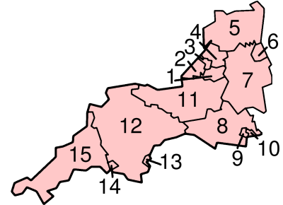 |
Somerset Somerset The ceremonial and non-metropolitan county of Somerset in South West England borders Bristol and Gloucestershire to the north, Wiltshire to the east, Dorset to the south-east, and Devon to the south-west. It is partly bounded to the north and west by the Bristol Channel and the estuary of the... |
1. Bath and North East Somerset Bath and North East Somerset Bath and North East Somerset is a unitary authority that was created on 1 April 1996 following the abolition of the County of Avon. It is part of the Ceremonial county of Somerset... UA |
|
| 2. North Somerset North Somerset North Somerset is a unitary authority in England. Its area covers part of the ceremonial county of Somerset but it is administered independently of the non-metropolitan county. Its administrative headquarters is in the town hall in Weston-super-Mare.... UA |
|||
| 11. Somerset CC Somerset County Council Somerset County Council is the county council of Somerset in the South West of England, an elected local government authority responsible for the most significant local government services in most of the county.-Area covered:... |
South Somerset South Somerset South Somerset is a local government district in Somerset, England.The South Somerset district covers and area of ranging from the borders with Devon and Dorset to the edge of the Somerset Levels. It has a population of approximately 158,000... , Taunton Deane Taunton Deane Taunton Deane is a local government district with borough status in Somerset, England. Its council is based in Taunton.The district was formed on 1 April 1974, under the Local Government Act 1972, by a merger of the Municipal Borough of Taunton, Wellington Urban District, Taunton Rural District,... , West Somerset West Somerset West Somerset is a local government district in the English county of Somerset. The council covers a largely rural area, with a population of 35,075 in an area of .... , Sedgemoor Sedgemoor Sedgemoor is a low lying area of land in Somerset, England. It lies close to sea level south of the Polden Hills, historically largely marsh . The eastern part is known as King's Sedgemoor, and the western part West Sedgemoor. Sedgemoor is part of the area now known as the Somerset Levels... , Mendip Mendip Mendip is a local government district of Somerset in England. The Mendip district covers a largely rural area of ranging from the Mendip Hills through on to the Somerset Levels. It has a population of approximately 110,000... |
||
| 3. Bristol Bristol Bristol is a city, unitary authority area and ceremonial county in South West England, with an estimated population of 433,100 for the unitary authority in 2009, and a surrounding Larger Urban Zone with an estimated 1,070,000 residents in 2007... UA |
|||
| Gloucestershire Gloucestershire Gloucestershire is a county in South West England. The county comprises part of the Cotswold Hills, part of the flat fertile valley of the River Severn, and the entire Forest of Dean.... |
4. South Gloucestershire South Gloucestershire South Gloucestershire is a unitary district in the ceremonial county of Gloucestershire, in South West England.-History:The district was created in 1996, when the county of Avon was abolished, by the merger of former area of the districts of Kingswood and Northavon... UA |
||
| 5. Gloucestershire CC | Gloucester Gloucester Gloucester is a city, district and county town of Gloucestershire in the South West region of England. Gloucester lies close to the Welsh border, and on the River Severn, approximately north-east of Bristol, and south-southwest of Birmingham.... , Tewkesbury Tewkesbury (borough) Tewkesbury is a local government district and borough in Gloucestershire, in the West Country of England. It is named after its main town, Tewkesbury... , Cheltenham Cheltenham Cheltenham , also known as Cheltenham Spa, is a large spa town and borough in Gloucestershire, on the edge of the Cotswolds in the South-West region of England. It is the home of the flagship race of British steeplechase horse racing, the Gold Cup, the main event of the Cheltenham Festival held... , Cotswold Cotswold (district) Cotswold is a local government district in Gloucestershire in England. It is named after the wider Cotswolds region. Its main town is Cirencester.... , Stroud Stroud (district) Stroud is a local government district in Gloucestershire, England. It is named after its largest town, Stroud, and has its administrative headquarters in Ebley Mill, in the Ebley area on the outskirts of the town.thumb |left |Ebley Mill... , Forest of Dean Forest of Dean (district) Forest of Dean is a local government district in Gloucestershire, England, named after the Forest of Dean. Its council is based in Coleford. Other towns in the district include Cinderford, Newent and Tidenham.... |
||
| Wiltshire Wiltshire Wiltshire is a ceremonial county in South West England. It is landlocked and borders the counties of Dorset, Somerset, Hampshire, Gloucestershire, Oxfordshire and Berkshire. It contains the unitary authority of Swindon and covers... |
6. Swindon Swindon (borough) The Borough of Swindon is a local government authority in South West England. It is centred on the town of Swindon and forms part of the ceremonial county of Wiltshire... UA |
||
| 7. Wiltshire UA Wiltshire Council Wiltshire Council is the unitary authority for most of the county of Wiltshire, in the West of England, the successor authority to Wiltshire County Council and to four districts—Kennet, North Wiltshire, Salisbury, and West Wiltshire—all of which had been created in 1973 and were... |
|||
| Dorset Dorset Dorset , is a county in South West England on the English Channel coast. The county town is Dorchester which is situated in the south. The Hampshire towns of Bournemouth and Christchurch joined the county with the reorganisation of local government in 1974... |
8. Dorset CC Dorset County Council Dorset County Council is the county council of the Dorset in England. It provides the upper tier of local government, below which are district councils, and town and parish councils... |
Weymouth and Portland Weymouth and Portland Weymouth and Portland is a local government district and borough in Dorset, England. It consists of the resort of Weymouth and the Isle of Portland, and includes the areas of Wyke Regis, Preston, Melcombe Regis, Upwey, Broadwey, Southill, Chiswell, Castletown, Fortuneswell, Radipole, Nottington,... , West Dorset West Dorset West Dorset is a local government district and parliamentary constituency in Dorset, England. Its council is based in Dorchester. The district was formed on 1 April 1974, under the Local Government Act 1972, and was a merger of the boroughs of Bridport, Dorchester and Lyme Regis, along with... , North Dorset North Dorset North Dorset is a local government district in Dorset, England. It is largely rural, but includes the towns of Blandford Forum, Gillingham, Shaftesbury, Stalbridge and Sturminster Newton. Much of North Dorset is in the River Stour valley and is called the Blackmore Vale... , Purbeck, East Dorset East Dorset East Dorset is a local government district in Dorset, England. Its council is based in Furzehill, near Wimborne Minster.The district was formed on 1 April 1974 by the merger of Wimborne Minster Urban District with part of the Ringwood and Fordingbridge Rural District and the Wimborne and Cranborne... , Christchurch Christchurch, Dorset Christchurch is a borough and town in the county of Dorset on the south coast of England. The town adjoins Bournemouth in the west and the New Forest lies to the east. Historically in Hampshire, it joined Dorset with the reorganisation of local government in 1974 and is the most easterly borough in... |
|
| 9. Poole Poole Poole is a large coastal town and seaport in the county of Dorset, on the south coast of England. The town is east of Dorchester, and Bournemouth adjoins Poole to the east. The Borough of Poole was made a unitary authority in 1997, gaining administrative independence from Dorset County Council... UA |
|||
| 10. Bournemouth UA | |||
| Devon Devon Devon is a large county in southwestern England. The county is sometimes referred to as Devonshire, although the term is rarely used inside the county itself as the county has never been officially "shired", it often indicates a traditional or historical context.The county shares borders with... |
12. Devon CC Devon County Council Devon County Council is the county council administering the English county of Devon. Based in the city of Exeter, the council covers the non-metropolitan county area of Devon... |
Exeter Exeter Exeter is a historic city in Devon, England. It lies within the ceremonial county of Devon, of which it is the county town as well as the home of Devon County Council. Currently the administrative area has the status of a non-metropolitan district, and is therefore under the administration of the... , East Devon East Devon East Devon is a local government district in Devon, England. Its council is based in Sidmouth, and the largest town is Exmouth.The district was formed on 1 April 1974 by the merger of the borough of Honiton with the urban districts of Budleigh Salterton, Exmouth, Ottery St. Mary, Seaton, Sidmouth... , Mid Devon Mid Devon Mid Devon is a local government district in Devon, England. Its council is based in Tiverton.The district was formed under the Local Government Act 1972, on 1 April 1974 by the merger of the borough of Tiverton and Crediton urban district together with Tiverton Rural District, and Crediton Rural... , North Devon North Devon North Devon is the northern part of the English county of Devon. It is also the name of a local government district in Devon. Its council is based in Barnstaple. Other towns and villages in the North Devon District include Braunton, Fremington, Ilfracombe, Instow, South Molton, Lynton and Lynmouth... , Torridge Torridge Torridge is a local government district in Devon, England. Its council is based in Bideford. Other towns and villages in the district include Holsworthy, Great Torrington, Hartland and Westward Ho!. The Island of Lundy is administratively part of the District... , West Devon West Devon West Devon is a local government district and borough in Devon, England. Towns in the district include Chagford, Okehampton, Princetown, and Tavistock, where the council is based.... , South Hams South Hams South Hams is a local government district on the south coast of Devon, England with its headquarters in the town of Totnes. It contains the towns of Dartmouth, Kingsbridge, Ivybridge, Salcombe — the largest of which is Ivybridge with a population of 16,056.... , Teignbridge Teignbridge Teignbridge is a local government district in Devon, England. Its council is based in Newton Abbot.Other towns in the district include Ashburton, Dawlish and Teignmouth... |
|
| 13. Torbay Torbay Torbay is an east-facing bay and natural harbour, at the western most end of Lyme Bay in the south-west of England, situated roughly midway between the cities of Exeter and Plymouth. Part of the ceremonial county of Devon, Torbay was made a unitary authority on 1 April 1998... UA |
|||
| 14. Plymouth Plymouth Plymouth is a city and unitary authority area on the coast of Devon, England, about south-west of London. It is built between the mouths of the rivers Plym to the east and Tamar to the west, where they join Plymouth Sound... UA |
|||
| Cornwall Cornwall Cornwall is a unitary authority and ceremonial county of England, within the United Kingdom. It is bordered to the north and west by the Celtic Sea, to the south by the English Channel, and to the east by the county of Devon, over the River Tamar. Cornwall has a population of , and covers an area of... |
Isles of Scilly Isles of Scilly The Isles of Scilly form an archipelago off the southwestern tip of the Cornish peninsula of Great Britain. The islands have had a unitary authority council since 1890, and are separate from the Cornwall unitary authority, but some services are combined with Cornwall and the islands are still part... sui generis UA |
||
| 15. Cornwall UA | |||
UA = unitary authority
Unitary authority
A unitary authority is a type of local authority that has a single tier and is responsible for all local government functions within its area or performs additional functions which elsewhere in the relevant country are usually performed by national government or a higher level of sub-national...
CC = county council
County council
A county council is the elected administrative body governing an area known as a county. This term has slightly different meanings in different countries.-United Kingdom:...
South West Regional Assembly
South West Regional Assembly
The South West Regional Assembly was the regional assembly for the South West region of England, established in 1999.It was wound up in December 2008, and its functions taken on by the Strategic Leaders' Board, the executive arm of the newly established South West Councils. Cllr. Angus Campbell,...
(SWRA) was the regional assembly
Regional Assemblies in England
The Regional Assemblies of England were a group of indirectly elected regional bodies established originally under the name Regional Chambers by the Regional Development Agencies Act 1998. They were abolished on 31 March 2010 and replaced by Local Authority Leaders’ Boards...
for the South West region, established in 1999. It was based in Exeter
Exeter
Exeter is a historic city in Devon, England. It lies within the ceremonial county of Devon, of which it is the county town as well as the home of Devon County Council. Currently the administrative area has the status of a non-metropolitan district, and is therefore under the administration of the...
and Taunton
Taunton
Taunton is the county town of Somerset, England. The town, including its suburbs, had an estimated population of 61,400 in 2001. It is the largest town in the shire county of Somerset....
. The SWRA was a partnership of councillors from all local authorities in the region and representatives of various sectors with a role in the region's economic, social and environmental well-being. There was much opposition to the formation of the SWRA with critics saying it was an unelected unrepresentative and unaccountable "quango". The Regional Assembly was wound up in May 2009, and its functions taken on by the Strategic Leaders' Board (SLB) of South West Councils.
Politics
In the 2010 general election the South West contained 55 seats in the House of Commons. The ConservativesConservative Party (UK)
The Conservative Party, formally the Conservative and Unionist Party, is a centre-right political party in the United Kingdom that adheres to the philosophies of conservatism and British unionism. It is the largest political party in the UK, and is currently the largest single party in the House...
hold 36 seats, the Liberal Democrats
Liberal Democrats
The Liberal Democrats are a social liberal political party in the United Kingdom which supports constitutional and electoral reform, progressive taxation, wealth taxation, human rights laws, cultural liberalism, banking reform and civil liberties .The party was formed in 1988 by a merger of the...
15 and Labour
Labour Party (UK)
The Labour Party is a centre-left democratic socialist party in the United Kingdom. It surpassed the Liberal Party in general elections during the early 1920s, forming minority governments under Ramsay MacDonald in 1924 and 1929-1931. The party was in a wartime coalition from 1940 to 1945, after...
4.
South West England
South West England (European Parliament constituency)
South West England is a constituency of the European Parliament. For 2009 it elects 6 MEPs using the d'Hondt method of party-list proportional representation, reduced from 7 in 2004.-Boundaries:...
is one of the constituencies used for elections to the European Parliament
European Parliament
The European Parliament is the directly elected parliamentary institution of the European Union . Together with the Council of the European Union and the Commission, it exercises the legislative function of the EU and it has been described as one of the most powerful legislatures in the world...
. From the 2004 election onwards, Gibraltar
Gibraltar
Gibraltar is a British overseas territory located on the southern end of the Iberian Peninsula at the entrance of the Mediterranean. A peninsula with an area of , it has a northern border with Andalusia, Spain. The Rock of Gibraltar is the major landmark of the region...
has been included within the constituency for the purpose of elections to the European parliament only. As of the 2009 European Parliament election
European Parliament election, 2009 (United Kingdom)
The European Parliament election was the United Kingdom's component of the 2009 European Parliament election, the voting for which was held on Thursday 4 June 2009, coinciding with the 2009 local elections in England. Most of the results of the election were announced on Sunday 7 June, after...
, it is represented by three Conservative
Conservative Party (UK)
The Conservative Party, formally the Conservative and Unionist Party, is a centre-right political party in the United Kingdom that adheres to the philosophies of conservatism and British unionism. It is the largest political party in the UK, and is currently the largest single party in the House...
, two UKIP
United Kingdom Independence Party
The United Kingdom Independence Party is a eurosceptic and right-wing populist political party in the United Kingdom. Whilst its primary goal is the UK's withdrawal from the European Union, the party has expanded beyond its single-issue image to develop a more comprehensive party platform.UKIP...
and one Liberal Democrat
Liberal Democrats
The Liberal Democrats are a social liberal political party in the United Kingdom which supports constitutional and electoral reform, progressive taxation, wealth taxation, human rights laws, cultural liberalism, banking reform and civil liberties .The party was formed in 1988 by a merger of the...
Member of European Parliament (MEP).
Schools
SomersetSomerset
The ceremonial and non-metropolitan county of Somerset in South West England borders Bristol and Gloucestershire to the north, Wiltshire to the east, Dorset to the south-east, and Devon to the south-west. It is partly bounded to the north and west by the Bristol Channel and the estuary of the...
, the former area of Avon, Swindon
Swindon
Swindon is a large town within the borough of Swindon and ceremonial county of Wiltshire, in South West England. It is midway between Bristol, west and Reading, east. London is east...
and Cornwall
Cornwall
Cornwall is a unitary authority and ceremonial county of England, within the United Kingdom. It is bordered to the north and west by the Celtic Sea, to the south by the English Channel, and to the east by the county of Devon, over the River Tamar. Cornwall has a population of , and covers an area of...
have comprehensive school
Comprehensive school
A comprehensive school is a state school that does not select its intake on the basis of academic achievement or aptitude. This is in contrast to the selective school system, where admission is restricted on the basis of a selection criteria. The term is commonly used in relation to the United...
s. The other counties have some selective grammar school
Grammar school
A grammar school is one of several different types of school in the history of education in the United Kingdom and some other English-speaking countries, originally a school teaching classical languages but more recently an academically-oriented secondary school.The original purpose of mediaeval...
s. Gloucestershire
Gloucestershire
Gloucestershire is a county in South West England. The county comprises part of the Cotswold Hills, part of the flat fertile valley of the River Severn, and the entire Forest of Dean....
has six, Wiltshire
Wiltshire
Wiltshire is a ceremonial county in South West England. It is landlocked and borders the counties of Dorset, Somerset, Hampshire, Gloucestershire, Oxfordshire and Berkshire. It contains the unitary authority of Swindon and covers...
has two (both in Salisbury
Salisbury
Salisbury is a cathedral city in Wiltshire, England and the only city in the county. It is the second largest settlement in the county...
), Poole
Poole
Poole is a large coastal town and seaport in the county of Dorset, on the south coast of England. The town is east of Dorchester, and Bournemouth adjoins Poole to the east. The Borough of Poole was made a unitary authority in 1997, gaining administrative independence from Dorset County Council...
has two, Bournemouth
Bournemouth
Bournemouth is a large coastal resort town in the ceremonial county of Dorset, England. According to the 2001 Census the town has a population of 163,444, making it the largest settlement in Dorset. It is also the largest settlement between Southampton and Plymouth...
has two, Devon
Devon
Devon is a large county in southwestern England. The county is sometimes referred to as Devonshire, although the term is rarely used inside the county itself as the county has never been officially "shired", it often indicates a traditional or historical context.The county shares borders with...
has one, Plymouth
Plymouth
Plymouth is a city and unitary authority area on the coast of Devon, England, about south-west of London. It is built between the mouths of the rivers Plym to the east and Tamar to the west, where they join Plymouth Sound...
has three and Torbay
Torbay
Torbay is an east-facing bay and natural harbour, at the western most end of Lyme Bay in the south-west of England, situated roughly midway between the cities of Exeter and Plymouth. Part of the ceremonial county of Devon, Torbay was made a unitary authority on 1 April 1998...
has three.
There are around 205,000 at secondary schools in the region, the third lowest total after the North East
North East England
North East England is one of the nine official regions of England. It covers Northumberland, County Durham, Tyne and Wear, and Teesside . The only cities in the region are Durham, Newcastle upon Tyne and Sunderland...
and the East Midlands
East Midlands
The East Midlands is one of the regions of England, consisting of most of the eastern half of the traditional region of the Midlands. It encompasses the combined area of Nottinghamshire, Derbyshire, Leicestershire, Rutland, Northamptonshire and most of Lincolnshire...
. The region has fairly low overall truancy
Truancy
Truancy is any intentional unauthorized absence from compulsory schooling. The term typically describes absences caused by students of their own free will, and usually does not refer to legitimate "excused" absences, such as ones related to medical conditions...
. At secondary schools Bristol has the highest rate of persistent truants with 6.0%; Purbeck (Dorset) has the lowest rate with 2.3%, followed by East Dorset
East Dorset
East Dorset is a local government district in Dorset, England. Its council is based in Furzehill, near Wimborne Minster.The district was formed on 1 April 1974 by the merger of Wimborne Minster Urban District with part of the Ringwood and Fordingbridge Rural District and the Wimborne and Cranborne...
with 2.6%.
At GCSE
General Certificate of Secondary Education
The General Certificate of Secondary Education is an academic qualification awarded in a specified subject, generally taken in a number of subjects by students aged 14–16 in secondary education in England, Wales and Northern Ireland and is equivalent to a Level 2 and Level 1 in Key Skills...
in 2009, Bath and North East Somerset consistently performs the best, closely followed by Gloucestershire, Poole, and Wiltshire. Also above the UK average are Dorset, Torbay, North Somerset, Devon, Bournemouth, and Torbay, in descending order. The South West performs well at GCSE, with the only exception being the City of Bristol which is very low performing, and to a smaller extent, Swindon.
At A-level
GCE Advanced Level
The Advanced Level General Certificate of Education, commonly referred to as an A-level, is a qualification offered by education institutions in England, Northern Ireland, Wales, Cameroon, and the Cayman Islands...
in 2009, Bournemouth performs the best, and does so consistently every year, ahead of all the other areas including most of England. Gloucestershire again performs well, being next best, closely followed by Wiltshire. These areas and Somerset are the only ones in the South-West above the England average, and the top three out of the four have some selective schools and are the only three to perform above average at A-level and GCSE. Poole received much lower A-level results than normal in 2009. At A-level, the South West is not quite as well performing as other areas. Dorset does not perform much lower at A-level than GCSE on average, but Bristol performs much better at A-level than GCSE. Plymouth performs the worst, although Swindon has had that position in recent years.
There are 33 further education
Further education
Further education is a term mainly used in connection with education in the United Kingdom and Ireland. It is post-compulsory education , that is distinct from the education offered in universities...
colleges in the region. The main five FE colleges are Cornwall College
Cornwall College
Cornwall College is a further education college situated on various sites throughout Cornwall with its main centre in St Austell. The college is a member of the 157 Group of high performing schools...
, City of Bristol College
City of Bristol College
City of Bristol College is one of the largest further education colleges in the UK. Based in Bristol, the College continues to gain national recognition for its work with adults, young people and employers.- Awards :* LSIS Beacon status...
, Somerset College of Arts and Technology
Somerset College of Arts and Technology
Somerset College of Arts and Technology ' is a community college based in Taunton, in the county of Somerset, England. It was formed in 1974 after the merger of Somerset College of Art and Taunton Technical College. The college provides further and higher education courses, as well as a variety of...
, Bournemouth and Poole College
Bournemouth and Poole College
The Bournemouth and Poole College is a further education establishment based in Bournemouth and Poole on the south coast of England. It is one of the larger UK colleges catering for an average of 24,000 learners each year, and it is a member of the 157 Group of high performing schools.- Courses...
, and Truro College
Truro College
Truro College is a tertiary institution located in Truro, Cornwall, in the United Kingdom. Following an exchange of governing bodies, Truro College merged with Penwith College in April 2008—the combined institution is known as Truro and Penwith College, though the sites retain their original names...
. LSC areas (which fund FE colleges) follow the traditional county boundaries, except Devon and Cornwall (similar to their police force) share an LSC area. The regional LSC office is based at St Lawrence House in Bristol.
Higher education
- Bournemouth UniversityBournemouth UniversityBournemouth University is a university in and around the large south coast town of Bournemouth, UK...
- Bath Spa UniversityBath Spa UniversityBath Spa University is a university based in, and around, Bath, England. The institution was previously known as Bath College of Higher Education, and later Bath Spa University College...
- University of BathUniversity of BathThe University of Bath is a campus university located in Bath, United Kingdom. It received its Royal Charter in 1966....
- University of BristolUniversity of BristolThe University of Bristol is a public research university located in Bristol, United Kingdom. One of the so-called "red brick" universities, it received its Royal Charter in 1909, although its predecessor institution, University College, Bristol, had been in existence since 1876.The University is...
- University of ExeterUniversity of ExeterThe University of Exeter is a public university in South West England. It belongs to the 1994 Group, an association of 19 of the United Kingdom's smaller research-intensive universities....
- University of GloucestershireUniversity of GloucestershireThe University of Gloucestershire is a university primarily based in Gloucestershire, England, spread over four campuses, three in Cheltenham and one in Gloucester...
- University of PlymouthUniversity of PlymouthPlymouth University is the largest university in the South West of England, with over 30,000 students and is 9th largest in the United Kingdom by total number of students . It has almost 3,000 staff...
- University of the West of EnglandUniversity of the West of EnglandThe University of the West of England is a university based in the English city of Bristol. Its main campus is at Frenchay, about five miles north of the city centre...
(UWE)
There is also University College Falmouth
University College Falmouth
University College Falmouth is a British university college in Falmouth, Cornwall. Founded in 1902, it had previously been the Falmouth School of Art and then Falmouth College of Arts until it received taught degree-awarding powers in March 2005...
, The Arts University College at Bournemouth and University College Plymouth St Mark & St John (UCP Marjon) and four higher education colleges. The region has the lowest number of people registered on higher education courses at FE colleges.
The University of Bristol receives the most total funding, according to Higher Education Funding Council for England
Higher Education Funding Council for England
The Higher Education Funding Council for England is a non-departmental public body of the Department for Business, Innovation and Skills in the United Kingdom, which has been responsible for the distribution of funding to Universities and Colleges of Higher and Further Education in England since...
figures for the 2006/2007 academic year, and the largest research grant—twice as big as any other in the region. Bath has the next largest research grant, closely followed by Exeter. UWE and Plymouth get small research grants, but no other universities in the region receive much of a research grant. The University of Plymouth has the largest teaching grant.
Of the region's students (postgraduate and undergraduate), 50% are from the region, and around 40% from other regions. For full-time first degree students, 35% come from the region, around 22% are from South East England
South East England
South East England is one of the nine official regions of England, designated in 1994 and adopted for statistical purposes in 1999. It consists of Berkshire, Buckinghamshire, East Sussex, Hampshire, Isle of Wight, Kent, Oxfordshire, Surrey and West Sussex...
, and 8% are from London. Including the East of England
East of England
The East of England is one of the nine official regions of England. It was created in 1994 and was adopted for statistics from 1999. It includes the ceremonial counties of Essex, Hertfordshire, Bedfordshire, Cambridgeshire, Norfolk and Suffolk. Essex has the highest population in the region.Its...
, around 70% are from Southern England
Southern England
Southern England, the South and the South of England are imprecise terms used to refer to the southern counties of England bordering the English Midlands. It has a number of different interpretations of its geographic extents. The South is considered by many to be a cultural region with a distinct...
. 10% are from the Midlands
English Midlands
The Midlands, or the English Midlands, is the traditional name for the area comprising central England that broadly corresponds to the early medieval Kingdom of Mercia. It borders Southern England, Northern England, East Anglia and Wales. Its largest city is Birmingham, and it was an important...
, and 5% from Northern England
Northern England
Northern England, also known as the North of England, the North or the North Country, is a cultural region of England. It is not an official government region, but rather an informal amalgamation of counties. The southern extent of the region is roughly the River Trent, while the North is bordered...
. The main access for students from the north is the Cross Country Route. Around 33% of native South West students stay in the region, with 18% going to the South East (around 60% stay in the south of England). Around 14% go to Wales, but very few go to the East of England. Access by road or rail to the East of England region is not straight-forward, with around the same amount of travel as to Scotland. Many more native South West students are prepared to go to the north of England, than northern students are prepared to study in the South West. Once graduated, around 50% stay in the region, with 15% each going to London or the South East (around 80% find work in the south of England). Very few go elsewhere (especially the north of England); around 4% go to the West Midlands or Wales.
Local media
Local media include:- Two BBC regions - BBC South WestBBC South WestBBC South West is the BBC English Region serving Devon, Cornwall and the Channel Islands.-Television:BBC South Wests television service consists of the flagship regional news service Spotlight, the opt-out service BBC Channel Islands, the topical magazine programme Inside Out and a 20-minute...
, based in Plymouth which has the Spotlight programme and BBC WestBBC WestBBC West is the BBC English Region serving Bristol, Bath and North East Somerset, North Somerset, South Gloucestershire, Somerset, Gloucestershire and Wiltshire.-Television:...
based in CliftonClifton, BristolClifton is a suburb of the City of Bristol in England, and the name of both one of the city's thirty-five council wards. The Clifton ward also includes the areas of Cliftonwood and Hotwells...
in Bristol with the Points WestBBC Points WestBBC Points West is the BBC's regional news programme for the West of England, covering Bristol, Gloucestershire, Somerset and Wiltshire...
regional programme. ITV West is based in Bristol and Westcountry TelevisionWestcountry TelevisionWestcountry Television, is the ITV franchise holder in the South West of England, replacing its predecessor, TSW , from the 1 January 1993...
is based in PlymouthPlymouthPlymouth is a city and unitary authority area on the coast of Devon, England, about south-west of London. It is built between the mouths of the rivers Plym to the east and Tamar to the west, where they join Plymouth Sound...
. Their joint news programme is The West Country TonightThe West Country TonightThe West Country Tonight is a regional television news and current affairs programme, also including local sports news and local features of interest, produced by ITV West & Westcountry at its studios in Bristol...
. Parts of Dorset, including Bournemouth and Poole, also receive BBC SouthBBC SouthBBC South is the BBC English Region serving West Sussex, Hampshire, Dorset, western Berkshire, Oxfordshire, south east Wiltshire and the Isle of Wight.-Television:...
and ITV MeridianMeridian BroadcastingMeridian Broadcasting is the holder of the ITV franchise for the South and South East of England. The station is owned and operated by ITV plc, under the licensee of ITV Broadcasting Limited....
from SouthamptonSouthamptonSouthampton is the largest city in the county of Hampshire on the south coast of England, and is situated south-west of London and north-west of Portsmouth. Southampton is a major port and the closest city to the New Forest...
. Digital switchover from Mendip (for Points West) took place in April 2010, and for the Spotlight area it took place in mid-2009. - BBC Radios CornwallBBC Radio CornwallBBC Radio Cornwall is the BBC Local Radio service for Cornwall and the Isles of Scilly in the United Kingdom. It broadcasts from its studios on Phoenix Wharf in Truro on 95.2 in the east, 96.0 on the Isles of Scilly and 103.9 in the west MHz FM, as well as on DAB.Andrew George, MP for St Ives, has...
, DevonBBC Radio DevonBBC Radio Devon is the BBC Local Radio service for the English county of Devon. It began transmissions on 17 January 1983, replacing a previous breakfast show for Devon and Cornwall broadcast on the local frequencies of Radio 4....
, Somerset, SolentBBC Radio SolentBBC Radio Solent is the BBC Local Radio service for the Isle of Wight and the English counties of Hampshire and Dorset. Its studios are located in Southampton, in the same purpose-built office block in Havelock Road as the BBC South Today news studios, and there are district offices in Portsmouth,...
(Dorset), BristolBBC Radio BristolBBC Radio Bristol is the BBC Local Radio service for the English city of Bristol and the surrounding former Avon area. Launched in September 1970, it broadcasts from Broadcasting House in Bristol on FM frequencies 94.9 MHz , 104.6 MHz , 103.6 MHz , on AM 1548 kHz and on DAB.The...
, WiltshireBBC WiltshireBBC Wiltshire is the BBC Local Radio station and BBC Online service for the English county of Wiltshire. The station marked its 20th anniversary in 2009.-BBC Wiltshire Sound :...
, and GloucestershireBBC Radio GloucestershireBBC Radio Gloucestershire is the BBC Local Radio service for the English county of Gloucestershire, which started on 3 October 1988. It broadcasts from its studios in London Rd, Gloucester on 95 , 95.8 , 104.7 FM, 1413 in the Cotswolds & Forest of Dean AM and over the internet.-Transmitters:The...
. National radio is from North Hessary TorNorth Hessary TorThe North Hessary Tor is a hill 517 metres high just above Dartmoor Prison, in Princetown within Dartmoor Forest civil parish, which is located in the borough of West Devon, Devon, England...
and Wenvoe (west of Cardiff). - Commercial radio stations are Kiss 101Kiss 101Kiss 101 was a radio station in Bristol broadcasting out to South Wales and South West England playing Hip Hop, dance music and R&B. It now forms part of a national Kiss station, which also includes Kiss 105-108 and Kiss 100 and is owned by Bauer Radio.-History:The station originally started...
(Bristol), Star 107.2 (Bristol), Heart West CountryHeart West CountryHeart West Country is an Independent Local Radio station broadcasting to Bristol and Somerset. The station began broadcasting on 16 July 2010 as a result of a merger between Heart Bristol , Heart Bath and Heart Somerset .-History:The regional station originally broadcast as three separate stations...
, Pirate FMPirate FMPirate FM is one of the Independent Local Radio stations for Cornwall, playing a range of music from the 1960's to the present day.-Background:...
(Cornwall), Atlantic FMAtlantic FMAtlantic FM, is a radio station based in and serving Cornwall, United Kingdom. The station, owned by Atlantic Broadcasting Ltd, began broadcasting on July 6, 2006 at 0730 BST, and is broadcast from St Agnes...
(St AgnesSt Agnes, CornwallSt Agnes is a civil parish and a large village on the north coast of Cornwall, United Kingdom. The village is situated approximately five miles north of Redruth and ten miles southwest of Newquay....
), Heart DevonHeart DevonHeart Devon is a Independent Local Radio station broadcasting to Devon. The station began broadcasting on Friday 27 August 2010 as a result of a merger between Heart Exeter and Heart Torbay , Heart Plymouth , Heart North Devon and Heart South Devon .-History:The regional station...
, Heart Gloucestershire (Gloucester), Heart Wiltshire (Swindon), Palm 105.5Palm 105.5Palm 105.5 is a Independent Local Radio station based in Torquay, in Devon.Palm FM was awarded the local commercial radio licence for Torbay in September 2005, and began broadcasting in May 2006...
(Torquay), Total Star Somerset (former QuayWest 107.4FM in Bridgwater), Total Star Swindon (former Brunel FM), Total Star Warminster (former 3TR FM), Total Star Bath (former Bath FM), Nova Radio (Weston-super-MareWeston-super-MareWeston-super-Mare is a seaside resort, town and civil parish in the unitary authority of North Somerset, which is within the ceremonial county of Somerset, England. It is located on the Bristol Channel coast, south west of Bristol, spanning the coast between the bounding high ground of Worlebury...
), Spire FMSpire FMSpire FM was awarded the licence to broadcast to the City of Salisbury and surrounding areas by the former Radio Authority, now OFCOM, in 1991. The capital needed to launch the station was raised entirely from local investors....
(SalisburySalisburySalisbury is a cathedral city in Wiltshire, England and the only city in the county. It is the second largest settlement in the county...
), Wessex FMWessex FMWessex FM is a local radio station for the Weymouth, Dorchester and Bridport areas of Dorset. All content is broadcast from its studios in Dorchester, however the Big Top 40 Show is a network program...
(Dorchester), Fire Radio (Bournemouth), and Heart Solent (Bournemouth). - Regional newspapers include the Bristol Evening PostBristol Evening PostThe Bristol Evening Post is a newspaper covering news in the city of Bristol, including stories from the whole of Greater Bristol, Northern Somerset and South Gloucestershire....
, Western Daily PressWestern Daily PressThe Western Daily Press is a regional newspaper covering parts of South West England , mainly Gloucestershire, Wiltshire and Somerset as well as the metropolitan areas of Bath and North East Somerset and the Bristol area. It is published Monday to Saturday in Bristol, UK...
, the Dorset EchoDorset EchoThe Dorset Echo is a daily newspaper published in the county of Dorset, England.The title publishes Monday to Saturday from editorial offices in Weymouth, and covers issues concerning south, central and west Dorset...
, the Exeter Express and EchoExpress & EchoEstablished in 1904, the Express & Echo is a paid-for newspaper for Exeter and its surrounding area....
, Western Morning NewsWestern Morning NewsThe Western Morning News is a politically independent daily regional newspaper founded in 1860 and covering Devon and Cornwall and parts of Somerset and Dorset.-Organisation:...
, the North Devon Journal, Cornish GuardianCornish GuardianCornish Guardian is a weekly newspaper in Cornwall, UK, which is part of the Cornwall & Devon Media group. It is published in 7 separate editions:*Bodmin edition*Lostwithiel and Fowey edition*Newquay edition*North Cornwall edition...
, The West BritonThe West BritonThe West Briton is a local weekly newspaper published every Thursday. It serves different areas of Cornwall, United Kingdom with four separate editions—Truro and Mid-Cornwall, Falmouth and Penryn, Redruth Camborne and Hayle, and Helston and The Lizard. It was established in 1810 and is part...
(Truro), The CornishmanThe CornishmanThe Cornishman is a weekly newspaper based in Penzance, Cornwall, United Kingdom. It is published every Thursday.It formerly had a separate edition to cover the Isles of Scilly. However, it now just has one edition which covers the whole of the Penwith peninsula as well as the Isles of Scilly.It is...
, Wiltshire TimesWiltshire TimesThe Wiltshire Times is a weekly newspaper published in Trowbridge, Wiltshire in South West England. The paper serves the west Wiltshire towns of Bradford on Avon, Trowbridge, Corsham, Chippenham, Warminster, Westbury and Melksham as well as many of the small villages in the west Wiltshire...
(TrowbridgeTrowbridgeTrowbridge is the county town of Wiltshire, England, situated on the River Biss in the west of the county, approximately 12 miles southeast of Bath, Somerset....
), Gloucestershire EchoGloucestershire EchoThe Gloucestershire Echo is a daily paper produced by Gloucestershire Media, part of Northcliffe Media. It was founded in 1873.The newspaper is based in St James' House in the centre of Cheltenham...
, Gloucester Citizen, Plymouth Evening Herald, Torquay Herald ExpressTorquay Herald ExpressThe Herald Express is a local newspaper covering the Torbay area of the United Kingdom. It is published by Northcliffe Media whose ultimate parent is DMGT...
, Swindon AdvertiserSwindon AdvertiserThe Swindon Advertiser is a daily tabloid newspaper, published in Swindon. The newspaper was founded in 1854, and had a circulation in 2006 of 22,321....
and the Salisbury JournalSalisbury JournalThe Salisbury Journal is the local newspaper for the Salisbury area of England. It was founded in 1729. It is part of the Newsquest publishing company. It contains, among other things, local news, local sport reports, cars for sale, assorted classified advertisements and government and utility...
(SalisburySalisburySalisbury is a cathedral city in Wiltshire, England and the only city in the county. It is the second largest settlement in the county...
).