
River
Encyclopedia
A river is a natural watercourse
, usually freshwater
, flowing towards an ocean
, a lake
, a sea
, or another river. In a few cases, a river simply flows into the ground or dries up completely before reaching another body of water
. Small rivers may also be called by several other names, including stream
, creek, brook, rivulet, tributary and rill. There is no general rule that defines what can be called a river, although in some countries or communities a stream may be defined by its size. Many names for small rivers are specific to geographic location; one example is "burn" in Scotland
and northeast England. Sometimes a river is said to be larger than a creek, but this is not always the case, because of vagueness in the language.
Rivers are part of the hydrological cycle. Water within a river is generally collected from precipitation
through a drainage basin
from surface runoff
and other sources such as groundwater recharge, springs
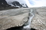
, and the release of stored water in natural ice and snowpacks (e.g., from glacier
s). Potamology is the scientific study of rivers.
 The water in a river is usually confined to a channel
, made up of a stream bed
between banks. In larger rivers there is also a wider floodplain shaped by flood
-waters over-topping the channel. Flood plains may be very wide in relation to the size of the river channel. This distinction between river channel and floodplain can be blurred especially in urban areas where the floodplain of a river channel can become greatly developed by housing and industry.
The term upriver refers to the direction leading to the source of the river, which is against the direction of flow. Likewise, the term downriver describes the direction towards the mouth of the river, in which the current flows
The river channel typically contains a single stream of water, but some rivers flow as several interconnecting streams of water, producing a braided river
. Extensive braided rivers are now found in only a few regions worldwide, such as the South Island
of New Zealand
. They also occur on peneplain
s and some of the larger river deltas. Anastamosing rivers are similar to braided rivers and are also quite rare. They have multiple sinuous channels carrying large volumes of sediment.
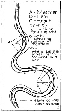
 A river flowing in its channel is a source of energy which acts on the river channel to change its shape and form. According to Brahm's law (sometimes called Airy's law), the mass of objects that may be carried away by a river is proportional to the sixth power of the river flow speed. Thus, when the speed of flow increases two times, it can transport 64 times larger (i.e., more massive) objects. In mountainous torrential zones this can be seen as erosion channels through hard rocks and the creation of sands and gravels from the destruction of larger rocks. In U-shaped glaciated valleys, the subsequent river valley can often easily be identified by the V-shaped channel that it has carved. In the middle reaches where the river may flow over flatter land, meander
s may form through erosion of the river banks and deposition on the inside of bends. Sometimes the river will cut off a loop, shortening the channel and forming an oxbow lake
or billabong
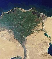
. Rivers that carry large amounts of sediment
may develop conspicuous deltas
at their mouths, if conditions permit. Rivers whose mouths are in saline tidal
waters may form estuaries
.
Throughout the course of the river, the total volume of water transported downstream will often be a combination of the free water flow together with a substantial contribution flowing through sub-surface rocks and gravels that underlie the river and its floodplain (called the hyporheic zone). For many rivers in large valleys, this unseen component of flow may greatly exceed the visible flow.
s flow underground in cave
s or caverns. Such rivers are frequently found in regions with limestone
geologic formation
s. Subglacial stream
s are the braided rivers that flow at the beds of glaciers and ice sheet
s, permitting meltwater to be discharged at the front of the glacier. Because of the gradient in pressure
due to the overlying weight of the glacier, such streams can even flow uphill.
river) only flows occasionally and can be dry for several years at a time. These rivers are found in regions with limited or highly variable rainfall, or can occur because of geologic conditions such as having a highly permeable river bed. Some ephemeral rivers flow during the summer months but not in the winter. Such rivers are typically fed from chalk aquifers which recharge from winter rainfall. In the UK these rivers are called Bournes and give their name to place such as Bournemouth
and Eastbourne
.
, their biotic
status, their relevance to white water rafting
or canoe
ing activities.
, bedrock
, or some mix of the two. Alluvial rivers have channels and floodplains that are self-formed in unconsolidated or weakly consolidated sediments. They erode
their banks and deposit material on bars
and their floodplain
s. Bedrock rivers form when the river downcuts through the modern sediments and into the underlying bedrock. This occurs in regions that have experienced some kind of uplift (thereby steepening river gradients) or in which a particular hard lithology
causes a river to have a steepened reach that has not been covered in modern alluvium
. Bedrock rivers very often contain alluvium on their beds; this material is important in eroding and sculpting the channel. Rivers that go through patches of bedrock and patches of deep alluvial cover are classified as mixed bedrock-alluvial.
Alluvial rivers can be further classified by their channel pattern
as meandering, braided, wandering, anastomose, or straight. The morphology of an alluvial river reach is controlled by a combination of sediment supply, substrate composition, discharge, vegetation, and bed aggradation
.
At the turn of the 20th century William Morris Davis
devised the "cycle of erosion
" method of classifying rivers based on their "age". Although Davis's system is still found in many books today, after the 1950s and 1960s it became increasingly criticized and rejected by geomorphologists. His scheme did not produce testable hypotheses and was therefore deemed non-scientific. Examples of Davis's river "ages" include:
The way in which a river's characteristics vary between the upper course and lower course of a river are summarized by the Bradshaw model
. Power-law relationships between channel slope, depth, and width are given as a function of discharge by "river regime
".
In Europe, the requirements of the Water Framework Directive
has led to the development of a wide range of classification methods including classifications based on fishery status
A system of river zonation used in francophone
communities divides rivers into three primary zones:
is used to rate the challenges of navigation—particularly those with rapids. Class I is the easiest and Class VI is the hardest.
ranks rivers based on the connectivity and hierarchy of contributing tributaries. Headwaters are first order while the Amazon River
is twelfth order. Approximately 80% of the rivers and streams in the world are of the first and second order.
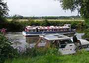 Rivers have been used as a source of water, for obtaining food, for transport
, as a defensive measure, as a source of hydropower
to drive machinery, for bathing, and as a means of disposing of waste.
Rivers have been used for navigation for thousands of years. The earliest evidence of navigation is found in the Indus Valley Civilization
, which existed in northwestern Pakistan
around 3300 BC. Riverine navigation provides a cheap means of transport, and is still used extensively on most major rivers of the world like the Amazon
, the Ganges
, the Nile
, the Mississippi
, and the Indus. Since river boats are often not regulated, they contribute a large amount to global greenhouse gas
emissions, and to local cancer due to inhaling of particulates
emitted by the transports.
In some heavily forested regions such as Scandinavia
and Canada
, lumberjack
s use the river to float felled trees downstream to lumber camps for further processing, saving much effort and cost by transporting the huge heavy logs by natural means.
Rivers have been a source of food since pre-history. They can provide a rich source of fish and other edible aquatic life, and are a major source of fresh water, which can be used for drinking and irrigation
. It is therefore no surprise to find most of the major cities of the world situated on the banks of rivers. Rivers help to determine the urban form
of cities and neighbourhoods and their corridors often present opportunities for urban renewal
through the development of foreshoreway
s such as riverwalk
s. Rivers also provide an easy means of disposing of waste-water and, in much of the less developed world, other wastes.
Fast flowing rivers and waterfalls are widely used as sources of energy, via watermill
s and hydroelectric plants. Evidence of watermills shows them in use for many hundreds of years such as in Orkney at Dounby click mill
. Prior to the invention of steam power, water-mills for grinding cereal
s and for processing wool
and other textiles were common across Europe
. In the 1890s the first machines to generate power from river water were established at places such as Cragside
in Northumberland
and in recent decades there has been a significant increase in the development of large scale power generation from water, especially in wet mountainous regions such as Norway
.
The coarse sediments, gravel
, and sand
, generated and moved by rivers are extensively used in construction. In parts of the world this can generate extensive new lake habitats as gravel pits re-fill with water. In other circumstances it can destabilise the river bed and the course of the river and cause severe damage to spawning fish populations which rely on stable gravel formations for egg laying.
In upland rivers, rapid
s with whitewater
or even waterfall
s occur. Rapids are often used for recreation, such as whitewater kayaking
.
Rivers have been important in determining political boundaries and defending countries. For example, the Danube
was a long-standing border of the Roman Empire
, and today it forms most of the border between Bulgaria
and Romania
. The Mississippi in North America
and the Rhine in Europe are major east-west boundaries in those continents. The Orange
and Limpopo
Rivers in southern Africa
form the boundaries between provinces and countries along their routes.
respond to changes in river channel location and patterns of flow. The ecosystem of rivers is generally described by the River continuum concept
, which has some additions and refinements to allow for spatial (dams, waterfalls) and temporal (extensive flooding). The basic idea is that the river can be described as a system that is continuously changing along its length in the physical parameters, the availability of food particles and the composition of the ecosystem. The food (energy) that is the leftover of the upstream part is being utilized downstream.
The general pattern is that the first order streams contain particulate matter (decaying leaves from the surrounding forests), which is processed there by shredders like Plecoptera
larvae. The leftovers of the shredders are utilized by collectors, such as Hydropsyche, and further downstream algae that create the primary production
become the main foodsource of the organisms. All changes are gradual and the distribution of each species can be described as a normal curve with the highest density where the conditions are optimal. In rivers succession
is virtually absent and the composition of the ecosystem stays fixed in time.
Like many other Aquatic ecosystem
s, rivers too are under increasing threat of pollution. According to a study of the WWF's Global Freshwater Programme, the 10 most polluted rivers are: Ganges, Indus, Yangtze, Salween-Nu, Mekong
-Lancang, Rio Grande/Rio Bravo
, Río de la Plata
, Danube
, Nile
-Lake Victoria
, and the Murray-Darling.
ing is a natural part of a river's cycle. The majority of the erosion of river channels and the erosion and deposition on the associated floodplain
s occur during flood stage
. In many developed areas, human activity has changed river channel form, altering different magnitudes and frequencies of flooding. Some examples of this are the building of levee
s, the straightening of channels, and the draining of natural wetland
s. In many cases human activities in rivers and floodplains have dramatically increased the risk of flooding. Straightening rivers allows water to flow more rapidly downstream increasing the risk of flooding places further downstream. Building on flood plains removes flood storage which again exacerbates downstream flooding. The building of levees may only protect the area behind the levees and not those further downstream. Levees and flood-banks can also increase flooding upstream because of back-water pressure as the upstream water has to squeeze between the levees.
 A common misconception is that most, or even all, rivers flow from north to south. Rivers in fact flow downhill regardless of compass direction. Sometimes downhill is from north to south, but equally it can be from south to north, and usually is a complex meandering path involving all directions of the compass. Three of the ten longest rivers in the world—the Nile
, Yenisei, and Ob
—flow north, as do other major rivers such as the Rhine, Mackenzie
, and Nelson
.
Rivers flowing downhill, from river source to river mouth, do not necessarily take the shortest path. For alluvial streams, straight and braided rivers have very low sinuosity and flow directly down hill, while meandering rivers flow from side to side across a valley. Bedrock rivers typically flow in either a fractal
pattern, or a pattern that is determined by weaknesses in the bedrock, such as faults, fractures, or more erodible layers.
, also called discharge, volume flow rate, and rate of water flow, is the volume of water which passes through a given cross-section of the river channel per unit time. It is typically measured in cubic meters per second (cumec) or cubic feet per second (cfs), where 1 m3/s = 35.51 ft3/s; it is sometimes also measured in litre
s or gallon
s per second.
Volumetric flow rate can be thought of as the mean velocity of the flow through a given cross-section, times that cross-sectional area. Mean velocity can be approximated through the use of the Law of the Wall. In general, velocity increases with the depth (or hydraulic radius) and slope of the river channel, while the cross-sectional area scales with the depth and the width: the double-counting of depth shows the importance of this variable in determining the discharge through the channel.
River management is a continuous activity as rivers tend to 'undo' the modifications made by people. Dredged channels silt up, sluice mechanisms
deteriorate with age, levees and dams may suffer seepage or catastrophic failure. The benefits sought through managing rivers may often be offset by the social and economic costs of mitigating the bad effects of such management. As an example, in parts of the developed world, rivers have been confined within channels to free up flat flood-plain land for development. Floods can inundate such development at high financial cost and often with loss of life.
Rivers are increasingly managed for habitat conservation
, as they are critical for many aquatic
and riparian
plants, resident
and migratory fish
es, waterfowl
, birds of prey
, migrating bird
s, and many mammal
s.
Crossings
Transport
Watercourse
A watercourse is any flowing body of water. These include rivers, streams, anabranches, and so forth.-See also:* physical geography* Environmental flow* Waterway* Hydrology* Wadi-External links:...
, usually freshwater
Freshwater
Fresh water is naturally occurring water on the Earth's surface in ice sheets, ice caps, glaciers, bogs, ponds, lakes, rivers and streams, and underground as groundwater in aquifers and underground streams. Fresh water is generally characterized by having low concentrations of dissolved salts and...
, flowing towards an ocean
Ocean
An ocean is a major body of saline water, and a principal component of the hydrosphere. Approximately 71% of the Earth's surface is covered by ocean, a continuous body of water that is customarily divided into several principal oceans and smaller seas.More than half of this area is over 3,000...
, a lake
Lake
A lake is a body of relatively still fresh or salt water of considerable size, localized in a basin, that is surrounded by land. Lakes are inland and not part of the ocean and therefore are distinct from lagoons, and are larger and deeper than ponds. Lakes can be contrasted with rivers or streams,...
, a sea
Sea
A sea generally refers to a large body of salt water, but the term is used in other contexts as well. Most commonly, it means a large expanse of saline water connected with an ocean, and is commonly used as a synonym for ocean...
, or another river. In a few cases, a river simply flows into the ground or dries up completely before reaching another body of water
Water
Water is a chemical substance with the chemical formula H2O. A water molecule contains one oxygen and two hydrogen atoms connected by covalent bonds. Water is a liquid at ambient conditions, but it often co-exists on Earth with its solid state, ice, and gaseous state . Water also exists in a...
. Small rivers may also be called by several other names, including stream
Stream
A stream is a body of water with a current, confined within a bed and stream banks. Depending on its locale or certain characteristics, a stream may be referred to as a branch, brook, beck, burn, creek, "crick", gill , kill, lick, rill, river, syke, bayou, rivulet, streamage, wash, run or...
, creek, brook, rivulet, tributary and rill. There is no general rule that defines what can be called a river, although in some countries or communities a stream may be defined by its size. Many names for small rivers are specific to geographic location; one example is "burn" in Scotland
Scotland
Scotland is a country that is part of the United Kingdom. Occupying the northern third of the island of Great Britain, it shares a border with England to the south and is bounded by the North Sea to the east, the Atlantic Ocean to the north and west, and the North Channel and Irish Sea to the...
and northeast England. Sometimes a river is said to be larger than a creek, but this is not always the case, because of vagueness in the language.
Rivers are part of the hydrological cycle. Water within a river is generally collected from precipitation
Precipitation (meteorology)
In meteorology, precipitation In meteorology, precipitation In meteorology, precipitation (also known as one of the classes of hydrometeors, which are atmospheric water phenomena is any product of the condensation of atmospheric water vapor that falls under gravity. The main forms of precipitation...
through a drainage basin
Drainage basin
A drainage basin is an extent or an area of land where surface water from rain and melting snow or ice converges to a single point, usually the exit of the basin, where the waters join another waterbody, such as a river, lake, reservoir, estuary, wetland, sea, or ocean...
from surface runoff
Surface runoff
Surface runoff is the water flow that occurs when soil is infiltrated to full capacity and excess water from rain, meltwater, or other sources flows over the land. This is a major component of the water cycle. Runoff that occurs on surfaces before reaching a channel is also called a nonpoint source...
and other sources such as groundwater recharge, springs
Spring (hydrosphere)
A spring—also known as a rising or resurgence—is a component of the hydrosphere. Specifically, it is any natural situation where water flows to the surface of the earth from underground...
, and the release of stored water in natural ice and snowpacks (e.g., from glacier
Glacier
A glacier is a large persistent body of ice that forms where the accumulation of snow exceeds its ablation over many years, often centuries. At least 0.1 km² in area and 50 m thick, but often much larger, a glacier slowly deforms and flows due to stresses induced by its weight...
s). Potamology is the scientific study of rivers.
Topography
Stream channel
Stream channel is the physical confine of a stream consisting of a bed and stream banks.Stream channels exist in a variety of geometries. The stream channel development is controlled by both water and sediment movement. There is a difference between low gradient streams and high gradient streams...
, made up of a stream bed
Stream bed
A stream bed is the channel bottom of a stream, river or creek; the physical confine of the normal water flow. The lateral confines or channel margins, during all but flood stage, are known as the stream banks or river banks. In fact, a flood occurs when a stream overflows its banks and flows onto...
between banks. In larger rivers there is also a wider floodplain shaped by flood
Flood
A flood is an overflow of an expanse of water that submerges land. The EU Floods directive defines a flood as a temporary covering by water of land not normally covered by water...
-waters over-topping the channel. Flood plains may be very wide in relation to the size of the river channel. This distinction between river channel and floodplain can be blurred especially in urban areas where the floodplain of a river channel can become greatly developed by housing and industry.
The term upriver refers to the direction leading to the source of the river, which is against the direction of flow. Likewise, the term downriver describes the direction towards the mouth of the river, in which the current flows
The river channel typically contains a single stream of water, but some rivers flow as several interconnecting streams of water, producing a braided river
Braided river
A braided river is one of a number of channel types and has a channel that consists of a network of small channels separated by small and often temporary islands called braid bars or, in British usage, aits or eyots. Braided streams occur in rivers with high slope and/or large sediment load...
. Extensive braided rivers are now found in only a few regions worldwide, such as the South Island
South Island
The South Island is the larger of the two major islands of New Zealand, the other being the more populous North Island. It is bordered to the north by Cook Strait, to the west by the Tasman Sea, to the south and east by the Pacific Ocean...
of New Zealand
New Zealand
New Zealand is an island country in the south-western Pacific Ocean comprising two main landmasses and numerous smaller islands. The country is situated some east of Australia across the Tasman Sea, and roughly south of the Pacific island nations of New Caledonia, Fiji, and Tonga...
. They also occur on peneplain
Peneplain
A peneplain is a low-relief plain representing the final stage of fluvial erosion during times of extended tectonic stability. The existence of peneplains, and peneplanation as a geomorphological process, is not without controversy, due to a lack of contemporary examples and uncertainty in...
s and some of the larger river deltas. Anastamosing rivers are similar to braided rivers and are also quite rare. They have multiple sinuous channels carrying large volumes of sediment.
Meander
A meander in general is a bend in a sinuous watercourse. A meander is formed when the moving water in a stream erodes the outer banks and widens its valley. A stream of any volume may assume a meandering course, alternately eroding sediments from the outside of a bend and depositing them on the...
s may form through erosion of the river banks and deposition on the inside of bends. Sometimes the river will cut off a loop, shortening the channel and forming an oxbow lake
Oxbow lake
An oxbow lake is a U-shaped body of water formed when a wide meander from the main stem of a river is cut off to create a lake. This landform is called an oxbow lake for the distinctive curved shape, named after part of a yoke for oxen. In Australia, an oxbow lake is called a billabong, derived...
or billabong
Billabong
Billabong is an Australian English word meaning a small lake, specifically an oxbow lake, a section of still water adjacent to a river, cut off by a change in the watercourse. Billabongs are usually formed when the path of a creek or river changes, leaving the former branch with a dead end...
. Rivers that carry large amounts of sediment
Sediment
Sediment is naturally occurring material that is broken down by processes of weathering and erosion, and is subsequently transported by the action of fluids such as wind, water, or ice, and/or by the force of gravity acting on the particle itself....
may develop conspicuous deltas
River delta
A delta is a landform that is formed at the mouth of a river where that river flows into an ocean, sea, estuary, lake, reservoir, flat arid area, or another river. Deltas are formed from the deposition of the sediment carried by the river as the flow leaves the mouth of the river...
at their mouths, if conditions permit. Rivers whose mouths are in saline tidal
Tide
Tides are the rise and fall of sea levels caused by the combined effects of the gravitational forces exerted by the moon and the sun and the rotation of the Earth....
waters may form estuaries
Estuary
An estuary is a partly enclosed coastal body of water with one or more rivers or streams flowing into it, and with a free connection to the open sea....
.
Throughout the course of the river, the total volume of water transported downstream will often be a combination of the free water flow together with a substantial contribution flowing through sub-surface rocks and gravels that underlie the river and its floodplain (called the hyporheic zone). For many rivers in large valleys, this unseen component of flow may greatly exceed the visible flow.
Subsurface streams
Most but not all rivers flow on the surface. Subterranean riverSubterranean river
A subterranean river is a river that runs wholly or partly beneath the ground surface – one where the riverbed does not represent the surface of the Earth ....
s flow underground in cave
Cave
A cave or cavern is a natural underground space large enough for a human to enter. The term applies to natural cavities some part of which is in total darkness. The word cave also includes smaller spaces like rock shelters, sea caves, and grottos.Speleology is the science of exploration and study...
s or caverns. Such rivers are frequently found in regions with limestone
Limestone
Limestone is a sedimentary rock composed largely of the minerals calcite and aragonite, which are different crystal forms of calcium carbonate . Many limestones are composed from skeletal fragments of marine organisms such as coral or foraminifera....
geologic formation
Geologic formation
A formation or geological formation is the fundamental unit of lithostratigraphy. A formation consists of a certain number of rock strata that have a comparable lithology, facies or other similar properties...
s. Subglacial stream
Subglacial stream
Subglacial streams are streams which flow in a channel at the bottom of an ice-sheet or a glacier, and are usually close to the glacier terminus or snout. These are fed by streams on top of the glacier which descend through ducts in the ice...
s are the braided rivers that flow at the beds of glaciers and ice sheet
Ice sheet
An ice sheet is a mass of glacier ice that covers surrounding terrain and is greater than 50,000 km² , thus also known as continental glacier...
s, permitting meltwater to be discharged at the front of the glacier. Because of the gradient in pressure
Pressure
Pressure is the force per unit area applied in a direction perpendicular to the surface of an object. Gauge pressure is the pressure relative to the local atmospheric or ambient pressure.- Definition :...
due to the overlying weight of the glacier, such streams can even flow uphill.
Permanence of flow
An intermittent river (or ephemeralEphemeral
Ephemeral things are transitory, existing only briefly. Typically the term is used to describe objects found in nature, although it can describe a wide range of things....
river) only flows occasionally and can be dry for several years at a time. These rivers are found in regions with limited or highly variable rainfall, or can occur because of geologic conditions such as having a highly permeable river bed. Some ephemeral rivers flow during the summer months but not in the winter. Such rivers are typically fed from chalk aquifers which recharge from winter rainfall. In the UK these rivers are called Bournes and give their name to place such as Bournemouth
Bournemouth
Bournemouth is a large coastal resort town in the ceremonial county of Dorset, England. According to the 2001 Census the town has a population of 163,444, making it the largest settlement in Dorset. It is also the largest settlement between Southampton and Plymouth...
and Eastbourne
Eastbourne
Eastbourne is a large town and borough in East Sussex, on the south coast of England between Brighton and Hastings. The town is situated at the eastern end of the chalk South Downs alongside the high cliff at Beachy Head...
.
Classification
Rivers have been classified by many criteria including their topographyTopography
Topography is the study of Earth's surface shape and features or those ofplanets, moons, and asteroids...
, their biotic
Biotic
Biotic is a living component of a community; for example organisms, such as plants and animals.Biotic may also refer to:*Life, the condition of living organisms,*Biology, the study of life,*Biotic material, which is derived from living organisms,...
status, their relevance to white water rafting
Rafting
Rafting or white water rafting is a challenging recreational outdoor activity using an inflatable raft to navigate a river or other bodies of water. This is usually done on white water or different degrees of rough water, in order to thrill and excite the raft passengers. The development of this...
or canoe
Canoe
A canoe or Canadian canoe is a small narrow boat, typically human-powered, though it may also be powered by sails or small electric or gas motors. Canoes are usually pointed at both bow and stern and are normally open on top, but can be decked over A canoe (North American English) or Canadian...
ing activities.
Topographical classification
Rivers can generally be classified as either alluvialAlluvial river
An alluvial river is river in which the bed and banks are made up of mobile sediment and/or soil. Alluvial rivers are self-formed, meaning that their channels are shaped by the magnitude and frequency of the floods that they experience, and the ability of these floods to erode, deposit, and...
, bedrock
Bedrock river
A bedrock river is a river that typically has little to no alluvium mantling the bedrock over which it flows. Such rivers are common in upland and mountainous regions...
, or some mix of the two. Alluvial rivers have channels and floodplains that are self-formed in unconsolidated or weakly consolidated sediments. They erode
Bank erosion
Bank erosion is the wearing away of the banks of a stream or river. This is distinguished from erosion of the bed of the watercourse, which is referred to as scour....
their banks and deposit material on bars
Bar (river morphology)
A bar in a river is an elevated region of sediment that has been deposited by the flow. Types of bars include mid-channel bars , point bars , and mouth bars...
and their floodplain
Floodplain
A floodplain, or flood plain, is a flat or nearly flat land adjacent a stream or river that stretches from the banks of its channel to the base of the enclosing valley walls and experiences flooding during periods of high discharge...
s. Bedrock rivers form when the river downcuts through the modern sediments and into the underlying bedrock. This occurs in regions that have experienced some kind of uplift (thereby steepening river gradients) or in which a particular hard lithology
Lithology
The lithology of a rock unit is a description of its physical characteristics visible at outcrop, in hand or core samples or with low magnification microscopy, such as colour, texture, grain size, or composition. It may be either a detailed description of these characteristics or be a summary of...
causes a river to have a steepened reach that has not been covered in modern alluvium
Alluvium
Alluvium is loose, unconsolidated soil or sediments, eroded, deposited, and reshaped by water in some form in a non-marine setting. Alluvium is typically made up of a variety of materials, including fine particles of silt and clay and larger particles of sand and gravel...
. Bedrock rivers very often contain alluvium on their beds; this material is important in eroding and sculpting the channel. Rivers that go through patches of bedrock and patches of deep alluvial cover are classified as mixed bedrock-alluvial.
Alluvial rivers can be further classified by their channel pattern
Channel pattern
Fluvial processes form several channel patterns, including:*Straight, which are found in the most tectonically incised/active areas. This is more of a hypothetical end-member, and are not often found in nature...
as meandering, braided, wandering, anastomose, or straight. The morphology of an alluvial river reach is controlled by a combination of sediment supply, substrate composition, discharge, vegetation, and bed aggradation
Aggradation
Aggradation is the term used in geology for the increase in land elevation due to the deposition of sediment. Aggradation occurs in areas in which the supply of sediment is greater than the amount of material that the system is able to transport...
.
At the turn of the 20th century William Morris Davis
William Morris Davis
William Morris Davis was an American geographer, geologist, geomorphologist, and meteorologist, often called the "father of American geography"....
devised the "cycle of erosion
Cycle of erosion
The cycle of erosion was a model for stream erosion and landscape development proposed by William Morris Davis in the late 19th century. Davis' Stages in the fluvial cycle of erosion published in 1909 defined a young, mature, and old sequence in the development of river valleys and the landscape...
" method of classifying rivers based on their "age". Although Davis's system is still found in many books today, after the 1950s and 1960s it became increasingly criticized and rejected by geomorphologists. His scheme did not produce testable hypotheses and was therefore deemed non-scientific. Examples of Davis's river "ages" include:
- Youthful river: A river with a steep gradient that has very few tributaries and flows quickly. Its channels erode deeper rather than wider. Examples include the BrazosBrazos RiverThe Brazos River, called the Rio de los Brazos de Dios by early Spanish explorers , is the longest river in Texas and the 11th longest river in the United States at from its source at the head of Blackwater Draw, Curry County, New Mexico to its mouth at the Gulf of Mexico with a drainage...
, TrinityTrinity River (California)The Trinity River is the longest tributary of the Klamath River, approximately long, in northwestern California in the United States. It drains an area of the Coast Ranges, including the southern Klamath Mountains, northwest of the Sacramento Valley...
and Ebro rivers.
- Mature river: A river with a gradient that is less steep than those of youthful rivers and flows more slowly. A mature river is fed by many tributaries and has more discharge than a youthful river. Its channels erode wider rather than deeper. Examples include the MississippiMississippi RiverThe Mississippi River is the largest river system in North America. Flowing entirely in the United States, this river rises in western Minnesota and meanders slowly southwards for to the Mississippi River Delta at the Gulf of Mexico. With its many tributaries, the Mississippi's watershed drains...
, Saint LawrenceSaint Lawrence RiverThe Saint Lawrence is a large river flowing approximately from southwest to northeast in the middle latitudes of North America, connecting the Great Lakes with the Atlantic Ocean. It is the primary drainage conveyor of the Great Lakes Basin...
, Danube, OhioOhio RiverThe Ohio River is the largest tributary, by volume, of the Mississippi River. At the confluence, the Ohio is even bigger than the Mississippi and, thus, is hydrologically the main stream of the whole river system, including the Allegheny River further upstream...
, ThamesRiver ThamesThe River Thames flows through southern England. It is the longest river entirely in England and the second longest in the United Kingdom. While it is best known because its lower reaches flow through central London, the river flows alongside several other towns and cities, including Oxford,...
and ParanáParaná RiverThe Paraná River is a river in south Central South America, running through Brazil, Paraguay and Argentina for some . It is second in length only to the Amazon River among South American rivers. The name Paraná is an abbreviation of the phrase "para rehe onáva", which comes from the Tupi language...
rivers.
- Old river: A river with a low gradient and low erosive energy. Old rivers are characterized by flood plains. Examples include the YellowYellow RiverThe Yellow River or Huang He, formerly known as the Hwang Ho, is the second-longest river in China and the sixth-longest in the world at the estimated length of . Originating in the Bayan Har Mountains in Qinghai Province in western China, it flows through nine provinces of China and empties into...
, Ganges, TigrisTigrisThe Tigris River is the eastern member of the two great rivers that define Mesopotamia, the other being the Euphrates. The river flows south from the mountains of southeastern Turkey through Iraq.-Geography:...
, EuphratesEuphratesThe Euphrates is the longest and one of the most historically important rivers of Western Asia. Together with the Tigris, it is one of the two defining rivers of Mesopotamia...
, IndusIndus RiverThe Indus River is a major river which flows through Pakistan. It also has courses through China and India.Originating in the Tibetan plateau of western China in the vicinity of Lake Mansarovar in Tibet Autonomous Region, the river runs a course through the Ladakh district of Jammu and Kashmir and...
and NileNileThe Nile is a major north-flowing river in North Africa, generally regarded as the longest river in the world. It is long. It runs through the ten countries of Sudan, South Sudan, Burundi, Rwanda, Democratic Republic of the Congo, Tanzania, Kenya, Ethiopia, Uganda and Egypt.The Nile has two major...
rivers.
- Rejuvenated river: A river with a gradient that is raised by tectonicTectonicsTectonics is a field of study within geology concerned generally with the structures within the lithosphere of the Earth and particularly with the forces and movements that have operated in a region to create these structures.Tectonics is concerned with the orogenies and tectonic development of...
uplift.
The way in which a river's characteristics vary between the upper course and lower course of a river are summarized by the Bradshaw model
Bradshaw model
The Bradshaw Model is a geographical model which describes how a river's characteristics vary between the upper course and lower course of a river. It shows that discharge, occupied channel width, channel depth and average load quantity increases downstream...
. Power-law relationships between channel slope, depth, and width are given as a function of discharge by "river regime
River regime
River regime can describe one of two characteristics of a reach of an alluvial river:* The variability in its discharge throughout the course of a year in response to precipitation, temperature, evapotranspiration, and drainage basin characteristics * A series of characteristic power-law...
".
Biotic classification
There are very many systems of classification based on biotic conditions typically assigning classes from the most oligotrophic or unpolluted through to the most eutrophic or polluted. Other systems are based on a whole eco-system approach such as developed by the New Zealand Ministry for the Environment.In Europe, the requirements of the Water Framework Directive
Water framework directive
The Water Framework Directive is a European Union directive which commits European Union member states to achieve good qualitative and quantitative status of all water bodies The Water Framework Directive (more formally the Directive 2000/60/EC of the European Parliament and of the Council of 23...
has led to the development of a wide range of classification methods including classifications based on fishery status
A system of river zonation used in francophone
Francophone
The adjective francophone means French-speaking, typically as primary language, whether referring to individuals, groups, or places. Often, the word is used as a noun to describe a natively French-speaking person....
communities divides rivers into three primary zones:
- The crenon is the uppermost zone at the source of the river. It is further divided into the eucrenon (spring or boil zone) and the hypocrenon (brook or headstream zone). These areas are characterized by low temperatures, reduced oxygen content and slow moving water.
- The rhithron is the upstream portion of the river that follows the crenon. It is characterized by relatively cool temperatures, high oxygen levels, and fast, turbulent flow.
- The potamon is the remaining downstream stretch of river. It is characterized by warmer temperatures, lower oxygen levels, slow flow and sandier bottoms.
Whitewater classification
The International Scale of River DifficultyInternational Scale of River Difficulty
The International Scale of River Difficulty is a standardized scale used to rate the safety of a stretch of river, or a single rapid. The grade reflects the technical difficulty and skill level required associated with the section of river...
is used to rate the challenges of navigation—particularly those with rapids. Class I is the easiest and Class VI is the hardest.
Stream order classification
The Strahler Stream OrderStrahler Stream Order
In mathematics, the Strahler number or Horton–Strahler number of a mathematical tree is a numerical measure of its branching complexity....
ranks rivers based on the connectivity and hierarchy of contributing tributaries. Headwaters are first order while the Amazon River
Amazon River
The Amazon of South America is the second longest river in the world and by far the largest by waterflow with an average discharge greater than the next seven largest rivers combined...
is twelfth order. Approximately 80% of the rivers and streams in the world are of the first and second order.
Uses
Navigation
Navigation is the process of monitoring and controlling the movement of a craft or vehicle from one place to another. It is also the term of art used for the specialized knowledge used by navigators to perform navigation tasks...
, as a defensive measure, as a source of hydropower
Hydropower
Hydropower, hydraulic power, hydrokinetic power or water power is power that is derived from the force or energy of falling water, which may be harnessed for useful purposes. Since ancient times, hydropower has been used for irrigation and the operation of various mechanical devices, such as...
to drive machinery, for bathing, and as a means of disposing of waste.
Rivers have been used for navigation for thousands of years. The earliest evidence of navigation is found in the Indus Valley Civilization
Indus Valley Civilization
The Indus Valley Civilization was a Bronze Age civilization that was located in the northwestern region of the Indian subcontinent, consisting of what is now mainly modern-day Pakistan and northwest India...
, which existed in northwestern Pakistan
Pakistan
Pakistan , officially the Islamic Republic of Pakistan is a sovereign state in South Asia. It has a coastline along the Arabian Sea and the Gulf of Oman in the south and is bordered by Afghanistan and Iran in the west, India in the east and China in the far northeast. In the north, Tajikistan...
around 3300 BC. Riverine navigation provides a cheap means of transport, and is still used extensively on most major rivers of the world like the Amazon
Amazon River
The Amazon of South America is the second longest river in the world and by far the largest by waterflow with an average discharge greater than the next seven largest rivers combined...
, the Ganges
Ganges River
The Ganges or Ganga, , is a trans-boundary river of India and Bangladesh. The river rises in the western Himalayas in the Indian state of Uttarakhand, and flows south and east through the Gangetic Plain of North India into Bangladesh, where it empties into the Bay of Bengal. By discharge it...
, the Nile
Nile
The Nile is a major north-flowing river in North Africa, generally regarded as the longest river in the world. It is long. It runs through the ten countries of Sudan, South Sudan, Burundi, Rwanda, Democratic Republic of the Congo, Tanzania, Kenya, Ethiopia, Uganda and Egypt.The Nile has two major...
, the Mississippi
Mississippi River
The Mississippi River is the largest river system in North America. Flowing entirely in the United States, this river rises in western Minnesota and meanders slowly southwards for to the Mississippi River Delta at the Gulf of Mexico. With its many tributaries, the Mississippi's watershed drains...
, and the Indus. Since river boats are often not regulated, they contribute a large amount to global greenhouse gas
Greenhouse gas
A greenhouse gas is a gas in an atmosphere that absorbs and emits radiation within the thermal infrared range. This process is the fundamental cause of the greenhouse effect. The primary greenhouse gases in the Earth's atmosphere are water vapor, carbon dioxide, methane, nitrous oxide, and ozone...
emissions, and to local cancer due to inhaling of particulates
Particulates
Particulates – also known as particulate matter , suspended particulate matter , fine particles, and soot – are tiny subdivisions of solid matter suspended in a gas or liquid. In contrast, aerosol refers to particles and/or liquid droplets and the gas together. Sources of particulate matter can be...
emitted by the transports.
In some heavily forested regions such as Scandinavia
Scandinavia
Scandinavia is a cultural, historical and ethno-linguistic region in northern Europe that includes the three kingdoms of Denmark, Norway and Sweden, characterized by their common ethno-cultural heritage and language. Modern Norway and Sweden proper are situated on the Scandinavian Peninsula,...
and Canada
Canada
Canada is a North American country consisting of ten provinces and three territories. Located in the northern part of the continent, it extends from the Atlantic Ocean in the east to the Pacific Ocean in the west, and northward into the Arctic Ocean...
, lumberjack
Lumberjack
A lumberjack is a worker in the logging industry who performs the initial harvesting and transport of trees for ultimate processing into forest products. The term usually refers to a bygone era when hand tools were used in harvesting trees principally from virgin forest...
s use the river to float felled trees downstream to lumber camps for further processing, saving much effort and cost by transporting the huge heavy logs by natural means.
Rivers have been a source of food since pre-history. They can provide a rich source of fish and other edible aquatic life, and are a major source of fresh water, which can be used for drinking and irrigation
Irrigation
Irrigation may be defined as the science of artificial application of water to the land or soil. It is used to assist in the growing of agricultural crops, maintenance of landscapes, and revegetation of disturbed soils in dry areas and during periods of inadequate rainfall...
. It is therefore no surprise to find most of the major cities of the world situated on the banks of rivers. Rivers help to determine the urban form
Urban design
Urban design concerns the arrangement, appearance and functionality of towns and cities, and in particular the shaping and uses of urban public space. It has traditionally been regarded as a disciplinary subset of urban planning, landscape architecture, or architecture and in more recent times has...
of cities and neighbourhoods and their corridors often present opportunities for urban renewal
Urban renewal
Urban renewal is a program of land redevelopment in areas of moderate to high density urban land use. Renewal has had both successes and failures. Its modern incarnation began in the late 19th century in developed nations and experienced an intense phase in the late 1940s – under the rubric of...
through the development of foreshoreway
Foreshoreway
A foreshoreway is a type of greenway that provides a public right of way along the edge of a waterbody.Foreshoreways are usually focused on sustainable behaviours and hence are a common facility for sustainable transport. The terminology was derived to assist to avoid the perception of a pavement...
s such as riverwalk
Riverwalk
Riverwalk is a name often given to a foreshoreway or pedestrian zone adjacent to a river.Some famous examples of riverwalks are:-In the United States:* Riverwalk in Fort Lauderdale, Florida* Tampa Riverwalk in Tampa, Florida...
s. Rivers also provide an easy means of disposing of waste-water and, in much of the less developed world, other wastes.
Fast flowing rivers and waterfalls are widely used as sources of energy, via watermill
Watermill
A watermill is a structure that uses a water wheel or turbine to drive a mechanical process such as flour, lumber or textile production, or metal shaping .- History :...
s and hydroelectric plants. Evidence of watermills shows them in use for many hundreds of years such as in Orkney at Dounby click mill
Dounby Click Mill
Dounby Click Mill is a mill located on the main island in the islands of Orkney. The Click Mill at Dounby is the last of the horizontal water-mills of Orkney, still in use. It has been restored and owned by Historic Scotland. -References:...
. Prior to the invention of steam power, water-mills for grinding cereal
Cereal
Cereals are grasses cultivated for the edible components of their grain , composed of the endosperm, germ, and bran...
s and for processing wool
Wool
Wool is the textile fiber obtained from sheep and certain other animals, including cashmere from goats, mohair from goats, qiviut from muskoxen, vicuña, alpaca, camel from animals in the camel family, and angora from rabbits....
and other textiles were common across Europe
Europe
Europe is, by convention, one of the world's seven continents. Comprising the westernmost peninsula of Eurasia, Europe is generally 'divided' from Asia to its east by the watershed divides of the Ural and Caucasus Mountains, the Ural River, the Caspian and Black Seas, and the waterways connecting...
. In the 1890s the first machines to generate power from river water were established at places such as Cragside
Cragside
Cragside is a country house in the civil parish of Cartington in Northumberland, England. It was the first house in the world to be lit using hydroelectric power...
in Northumberland
Northumberland
Northumberland is the northernmost ceremonial county and a unitary district in North East England. For Eurostat purposes Northumberland is a NUTS 3 region and is one of three boroughs or unitary districts that comprise the "Northumberland and Tyne and Wear" NUTS 2 region...
and in recent decades there has been a significant increase in the development of large scale power generation from water, especially in wet mountainous regions such as Norway
Norway
Norway , officially the Kingdom of Norway, is a Nordic unitary constitutional monarchy whose territory comprises the western portion of the Scandinavian Peninsula, Jan Mayen, and the Arctic archipelago of Svalbard and Bouvet Island. Norway has a total area of and a population of about 4.9 million...
.
The coarse sediments, gravel
Gravel
Gravel is composed of unconsolidated rock fragments that have a general particle size range and include size classes from granule- to boulder-sized fragments. Gravel can be sub-categorized into granule and cobble...
, and sand
Sand
Sand is a naturally occurring granular material composed of finely divided rock and mineral particles.The composition of sand is highly variable, depending on the local rock sources and conditions, but the most common constituent of sand in inland continental settings and non-tropical coastal...
, generated and moved by rivers are extensively used in construction. In parts of the world this can generate extensive new lake habitats as gravel pits re-fill with water. In other circumstances it can destabilise the river bed and the course of the river and cause severe damage to spawning fish populations which rely on stable gravel formations for egg laying.
In upland rivers, rapid
Rapid
A rapid is a section of a river where the river bed has a relatively steep gradient causing an increase in water velocity and turbulence. A rapid is a hydrological feature between a run and a cascade. A rapid is characterised by the river becoming shallower and having some rocks exposed above the...
s with whitewater
Whitewater
Whitewater is formed in a rapid, when a river's gradient increases enough to disturb its laminar flow and create turbulence, i.e. form a bubbly, or aerated and unstable current; the frothy water appears white...
or even waterfall
Waterfall
A waterfall is a place where flowing water rapidly drops in elevation as it flows over a steep region or a cliff.-Formation:Waterfalls are commonly formed when a river is young. At these times the channel is often narrow and deep. When the river courses over resistant bedrock, erosion happens...
s occur. Rapids are often used for recreation, such as whitewater kayaking
Whitewater kayaking
Whitewater kayaking is the sport of paddling a kayak on a moving body of water, typically a whitewater river. Whitewater kayaking can range from simple, carefree gently moving water, to demanding, dangerous whitewater. River rapids are graded like ski runs according to the difficulty, danger or...
.
Rivers have been important in determining political boundaries and defending countries. For example, the Danube
Danube
The Danube is a river in the Central Europe and the Europe's second longest river after the Volga. It is classified as an international waterway....
was a long-standing border of the Roman Empire
Roman Empire
The Roman Empire was the post-Republican period of the ancient Roman civilization, characterised by an autocratic form of government and large territorial holdings in Europe and around the Mediterranean....
, and today it forms most of the border between Bulgaria
Bulgaria
Bulgaria , officially the Republic of Bulgaria , is a parliamentary democracy within a unitary constitutional republic in Southeast Europe. The country borders Romania to the north, Serbia and Macedonia to the west, Greece and Turkey to the south, as well as the Black Sea to the east...
and Romania
Romania
Romania is a country located at the crossroads of Central and Southeastern Europe, on the Lower Danube, within and outside the Carpathian arch, bordering on the Black Sea...
. The Mississippi in North America
North America
North America is a continent wholly within the Northern Hemisphere and almost wholly within the Western Hemisphere. It is also considered a northern subcontinent of the Americas...
and the Rhine in Europe are major east-west boundaries in those continents. The Orange
Orange River
The Orange River , Gariep River, Groote River or Senqu River is the longest river in South Africa. It rises in the Drakensberg mountains in Lesotho, flowing westwards through South Africa to the Atlantic Ocean...
and Limpopo
Limpopo River
The Limpopo River rises in central southern Africa, and flows generally eastwards to the Indian Ocean. It is around long, with a drainage basin in size. Its mean annual discharge is 170 m³/s at its mouth...
Rivers in southern Africa
Southern Africa
Southern Africa is the southernmost region of the African continent, variably defined by geography or geopolitics. Within the region are numerous territories, including the Republic of South Africa ; nowadays, the simpler term South Africa is generally reserved for the country in English.-UN...
form the boundaries between provinces and countries along their routes.
Ecosystem
The organisms in the riparian zoneRiparian zone
A riparian zone or riparian area is the interface between land and a river or stream. Riparian is also the proper nomenclature for one of the fifteen terrestrial biomes of the earth. Plant habitats and communities along the river margins and banks are called riparian vegetation, characterized by...
respond to changes in river channel location and patterns of flow. The ecosystem of rivers is generally described by the River continuum concept
River continuum concept
The River Continuum Concept is a model for classifying and describing flowing water, in addition to the classification of individual sections of waters after the occurrence of indicator organisms...
, which has some additions and refinements to allow for spatial (dams, waterfalls) and temporal (extensive flooding). The basic idea is that the river can be described as a system that is continuously changing along its length in the physical parameters, the availability of food particles and the composition of the ecosystem. The food (energy) that is the leftover of the upstream part is being utilized downstream.
The general pattern is that the first order streams contain particulate matter (decaying leaves from the surrounding forests), which is processed there by shredders like Plecoptera
Plecoptera
Plecoptera are an order of insects, commonly known as stoneflies. There are some 3,500 described species worldwide, with new species still being discovered. Stoneflies are found worldwide, except Antarctica...
larvae. The leftovers of the shredders are utilized by collectors, such as Hydropsyche, and further downstream algae that create the primary production
Primary production
400px|thumb|Global oceanic and terrestrial photoautotroph abundance, from September [[1997]] to August 2000. As an estimate of autotroph biomass, it is only a rough indicator of primary production potential, and not an actual estimate of it...
become the main foodsource of the organisms. All changes are gradual and the distribution of each species can be described as a normal curve with the highest density where the conditions are optimal. In rivers succession
Succession
Succession is the act or process of following in order or sequence. It may further refer to:*Order of succession, in politics, the ascension to power by one ruler, official, or monarch after the death, resignation, or removal from office of another, usually in a clearly defined order*Succession...
is virtually absent and the composition of the ecosystem stays fixed in time.
Chemistry
The chemistry of rivers is complex and depends on inputs from the atmosphere, the geology through which it travels and the inputs from man's activities. The chemistry of the water has a large impact on the ecology of that water for both plants and animals and it also affects the uses that may be made of the river water. Understanding and characterising river water chemistry requires a well designed and managed sampling and analysis.Like many other Aquatic ecosystem
Aquatic ecosystem
An aquatic ecosystem is an ecosystem in a body of water. Communities of organisms that are dependent on each other and on their environment live in aquatic ecosystems. The two main types of aquatic ecosystems are marine ecosystems and freshwater ecosystems....
s, rivers too are under increasing threat of pollution. According to a study of the WWF's Global Freshwater Programme, the 10 most polluted rivers are: Ganges, Indus, Yangtze, Salween-Nu, Mekong
Mekong
The Mekong is a river that runs through China, Burma, Laos, Thailand, Cambodia and Vietnam. It is the world's 10th-longest river and the 7th-longest in Asia. Its estimated length is , and it drains an area of , discharging of water annually....
-Lancang, Rio Grande/Rio Bravo
Rio Grande
The Rio Grande is a river that flows from southwestern Colorado in the United States to the Gulf of Mexico. Along the way it forms part of the Mexico – United States border. Its length varies as its course changes...
, Río de la Plata
Río de la Plata
The Río de la Plata —sometimes rendered River Plate in British English and the Commonwealth, and occasionally rendered [La] Plata River in other English-speaking countries—is the river and estuary formed by the confluence of the Uruguay River and the Paraná River on the border between Argentina and...
, Danube
Danube
The Danube is a river in the Central Europe and the Europe's second longest river after the Volga. It is classified as an international waterway....
, Nile
Nile
The Nile is a major north-flowing river in North Africa, generally regarded as the longest river in the world. It is long. It runs through the ten countries of Sudan, South Sudan, Burundi, Rwanda, Democratic Republic of the Congo, Tanzania, Kenya, Ethiopia, Uganda and Egypt.The Nile has two major...
-Lake Victoria
Lake Victoria
Lake Victoria is one of the African Great Lakes. The lake was named for Queen Victoria of the United Kingdom, by John Hanning Speke, the first European to discover this lake....
, and the Murray-Darling.
Brackish water
Some rivers generate brackish water by having their river mouth in the ocean. This, in effect creates a unique environment in which certain species are found.Flooding
FloodFlood
A flood is an overflow of an expanse of water that submerges land. The EU Floods directive defines a flood as a temporary covering by water of land not normally covered by water...
ing is a natural part of a river's cycle. The majority of the erosion of river channels and the erosion and deposition on the associated floodplain
Floodplain
A floodplain, or flood plain, is a flat or nearly flat land adjacent a stream or river that stretches from the banks of its channel to the base of the enclosing valley walls and experiences flooding during periods of high discharge...
s occur during flood stage
Flood stage
Flood stage is the level at which the surface of a river, creek, or other body of water has risen to a sufficient level to cause damage or affects use of man-made structures...
. In many developed areas, human activity has changed river channel form, altering different magnitudes and frequencies of flooding. Some examples of this are the building of levee
Levee
A levee, levée, dike , embankment, floodbank or stopbank is an elongated naturally occurring ridge or artificially constructed fill or wall, which regulates water levels...
s, the straightening of channels, and the draining of natural wetland
Wetland
A wetland is an area of land whose soil is saturated with water either permanently or seasonally. Wetlands are categorised by their characteristic vegetation, which is adapted to these unique soil conditions....
s. In many cases human activities in rivers and floodplains have dramatically increased the risk of flooding. Straightening rivers allows water to flow more rapidly downstream increasing the risk of flooding places further downstream. Building on flood plains removes flood storage which again exacerbates downstream flooding. The building of levees may only protect the area behind the levees and not those further downstream. Levees and flood-banks can also increase flooding upstream because of back-water pressure as the upstream water has to squeeze between the levees.
Direction
Nile
The Nile is a major north-flowing river in North Africa, generally regarded as the longest river in the world. It is long. It runs through the ten countries of Sudan, South Sudan, Burundi, Rwanda, Democratic Republic of the Congo, Tanzania, Kenya, Ethiopia, Uganda and Egypt.The Nile has two major...
, Yenisei, and Ob
Ob River
The Ob River , also Obi, is a major river in western Siberia, Russia and is the world's seventh longest river. It is the westernmost of the three great Siberian rivers that flow into the Arctic Ocean .The Gulf of Ob is the world's longest estuary.-Names:The Ob is known to the Khanty people as the...
—flow north, as do other major rivers such as the Rhine, Mackenzie
Mackenzie River
The Mackenzie River is the largest river system in Canada. It flows through a vast, isolated region of forest and tundra entirely within the country's Northwest Territories, although its many tributaries reach into four other Canadian provinces and territories...
, and Nelson
Nelson River
The Nelson River is a river of north-central North America, in the Canadian province of Manitoba. Its full length is , it has mean discharge of , and has a drainage basin of , of which is in the United States...
.
Rivers flowing downhill, from river source to river mouth, do not necessarily take the shortest path. For alluvial streams, straight and braided rivers have very low sinuosity and flow directly down hill, while meandering rivers flow from side to side across a valley. Bedrock rivers typically flow in either a fractal
Fractal
A fractal has been defined as "a rough or fragmented geometric shape that can be split into parts, each of which is a reduced-size copy of the whole," a property called self-similarity...
pattern, or a pattern that is determined by weaknesses in the bedrock, such as faults, fractures, or more erodible layers.
Rate
Volumetric flow rateVolumetric flow rate
The volumetric flow rate in fluid dynamics and hydrometry, is the volume of fluid which passes through a given surface per unit time...
, also called discharge, volume flow rate, and rate of water flow, is the volume of water which passes through a given cross-section of the river channel per unit time. It is typically measured in cubic meters per second (cumec) or cubic feet per second (cfs), where 1 m3/s = 35.51 ft3/s; it is sometimes also measured in litre
Litre
pic|200px|right|thumb|One litre is equivalent to this cubeEach side is 10 cm1 litre water = 1 kilogram water The litre is a metric system unit of volume equal to 1 cubic decimetre , to 1,000 cubic centimetres , and to 1/1,000 cubic metre...
s or gallon
Gallon
The gallon is a measure of volume. Historically it has had many different definitions, but there are three definitions in current use: the imperial gallon which is used in the United Kingdom and semi-officially within Canada, the United States liquid gallon and the lesser used United States dry...
s per second.
Volumetric flow rate can be thought of as the mean velocity of the flow through a given cross-section, times that cross-sectional area. Mean velocity can be approximated through the use of the Law of the Wall. In general, velocity increases with the depth (or hydraulic radius) and slope of the river channel, while the cross-sectional area scales with the depth and the width: the double-counting of depth shows the importance of this variable in determining the discharge through the channel.
Sediment Yield
Sediment yield is the total quantity of particulate matter (suspended or bedload) reaching the outlet of a drainage basin over a fixed time frame. Yield is usually expressed as kilograms per square kilometre per year. Sediment delivery processes are affected by a myriad of factors such as drainage area size, basin slope, climate, sediment type (lithology), vegetation cover, and human land use / management practices. The theoretical concept of the 'sediment delivery ratio' (ratio between yield and total amount of sediment eroded) captures the fact that not all of the sediment eroded within a catchment reaches the outlet (due to, for example, deposition on floodplains). Such storage opportunities are typically increased in catchments of larger size, thus leading to a lower yield and sediment delivery ratio.Management
Rivers are often managed or controlled to make them more useful, or less disruptive, to human activity.- DamDamA dam is a barrier that impounds water or underground streams. Dams generally serve the primary purpose of retaining water, while other structures such as floodgates or levees are used to manage or prevent water flow into specific land regions. Hydropower and pumped-storage hydroelectricity are...
s or weirWeirA weir is a small overflow dam used to alter the flow characteristics of a river or stream. In most cases weirs take the form of a barrier across the river that causes water to pool behind the structure , but allows water to flow over the top...
s may be built to control the flow, store water, or extract energy. - LeveeLeveeA levee, levée, dike , embankment, floodbank or stopbank is an elongated naturally occurring ridge or artificially constructed fill or wall, which regulates water levels...
s, known as dikes in Europe, may be built to prevent river water from flowing on floodplains or floodways. - CanalCanalCanals are man-made channels for water. There are two types of canal:#Waterways: navigable transportation canals used for carrying ships and boats shipping goods and conveying people, further subdivided into two kinds:...
s connect rivers to one another for water transfer or navigationNavigationNavigation is the process of monitoring and controlling the movement of a craft or vehicle from one place to another. It is also the term of art used for the specialized knowledge used by navigators to perform navigation tasks...
. - River courses may be modified to improve navigation, or straightened to increase the flow rate.
River management is a continuous activity as rivers tend to 'undo' the modifications made by people. Dredged channels silt up, sluice mechanisms
Sluice
A sluice is a water channel that is controlled at its head by a gate . For example, a millrace is a sluice that channels water toward a water mill...
deteriorate with age, levees and dams may suffer seepage or catastrophic failure. The benefits sought through managing rivers may often be offset by the social and economic costs of mitigating the bad effects of such management. As an example, in parts of the developed world, rivers have been confined within channels to free up flat flood-plain land for development. Floods can inundate such development at high financial cost and often with loss of life.
Rivers are increasingly managed for habitat conservation
Habitat conservation
Habitat conservation is a land management practice that seeks to conserve, protect and restore, habitat areas for wild plants and animals, especially conservation reliant species, and prevent their extinction, fragmentation or reduction in range...
, as they are critical for many aquatic
Aquatic plant
Aquatic plants are plants that have adapted to living in aquatic environments. They are also referred to as hydrophytes or aquatic macrophytes. These plants require special adaptations for living submerged in water, or at the water's surface. Aquatic plants can only grow in water or in soil that is...
and riparian
Riparian zone
A riparian zone or riparian area is the interface between land and a river or stream. Riparian is also the proper nomenclature for one of the fifteen terrestrial biomes of the earth. Plant habitats and communities along the river margins and banks are called riparian vegetation, characterized by...
plants, resident
Freshwater fish
Freshwater fish are fish that spend some or all of their lives in freshwater, such as rivers and lakes, with a salinity of less than 0.05%. These environments differ from marine conditions in many ways, the most obvious being the difference in levels of salinity...
and migratory fish
Fish migration
Many types of fish migrate on a regular basis, on time scales ranging from daily to annually or longer, and over distances ranging from a few metres to thousands of kilometres...
es, waterfowl
Waterfowl
Waterfowl are certain wildfowl of the order Anseriformes, especially members of the family Anatidae, which includes ducks, geese, and swans....
, birds of prey
Bird of prey
Birds of prey are birds that hunt for food primarily on the wing, using their keen senses, especially vision. They are defined as birds that primarily hunt vertebrates, including other birds. Their talons and beaks tend to be relatively large, powerful and adapted for tearing and/or piercing flesh....
, migrating bird
Bird migration
Bird migration is the regular seasonal journey undertaken by many species of birds. Bird movements include those made in response to changes in food availability, habitat or weather. Sometimes, journeys are not termed "true migration" because they are irregular or in only one direction...
s, and many mammal
Mammal
Mammals are members of a class of air-breathing vertebrate animals characterised by the possession of endothermy, hair, three middle ear bones, and mammary glands functional in mothers with young...
s.
See also
- AqueductAqueductAn aqueduct is a water supply or navigable channel constructed to convey water. In modern engineering, the term is used for any system of pipes, ditches, canals, tunnels, and other structures used for this purpose....
- Baer's lawBaer's lawIn geology, Baer's law, named after Karl Ernst von Baer, says that, because of the rotation of the earth, in the Northern Hemisphere, erosion occurs mostly on the right banks of rivers and in the Southern Hemisphere on the left banks...
- Blackwater riverBlackwater riverA blackwater river is a river with a deep, slow-moving channel that flows through forested swamps and wetlands. As vegetation decays in the water, tannins are leached out, resulting in transparent, acidic water that is darkly stained, resembling tea or coffee. Most major blackwater rivers are in...
- CanalCanalCanals are man-made channels for water. There are two types of canal:#Waterways: navigable transportation canals used for carrying ships and boats shipping goods and conveying people, further subdivided into two kinds:...
- DroughtDroughtA drought is an extended period of months or years when a region notes a deficiency in its water supply. Generally, this occurs when a region receives consistently below average precipitation. It can have a substantial impact on the ecosystem and agriculture of the affected region...
- Hack's lawHack's lawHack's law is an empirical relationship between the length of streams and the area of their basins. If L is the length of the longest stream in a basin, and A is the area of the basin, then Hack's law may be written asL = C A^h\...
- List of international border rivers
- List of rivers by discharge
- List of rivers by length
- List of rivers of Africa
- List of rivers of Asia
- List of rivers of Europe
- List of rivers of Oceania
- List of rivers of the Americas
- List of river name etymologies
- List of waterways
- Mainstem (hydrology)Mainstem (hydrology)In relation to hydrology, a main stem is "the primary downstream segment of a river, as contrasted to its tributaries". Another common term for the main stem, the final large channel of a riverine system, is the trunk. Water enters the main stem from the river's drainage basin, the land area...
- Playfair's LawPlayfair's LawIn estimating erosion, Playfair's Law is an empirical relationship that relates the size of a stream to the valley it runs through. The role of the flow regiment requires subject attention; the relation acts fundamentally similar to the functionality of a glacial trough...
- River civilizationRiver civilizationA river civilization or river culture is an agricultural nation or civilization at a river. River civilizations are civilizations based around rivers. Some common examples are Ancient Egypt , the fertile crescent , Ancient China and Ancient India .Rivers provide a steady supply of drinking water...
- River continuum conceptRiver continuum conceptThe River Continuum Concept is a model for classifying and describing flowing water, in addition to the classification of individual sections of waters after the occurrence of indicator organisms...
- River cruiseRiver cruiseA River cruise is a voyage along inland waterways, often stopping at multiple ports along the way. Since cities and towns often grew up around rivers, river cruise ships frequently dock in the center of cities and towns.- Descriptions :...
- The RiverkeepersThe RiverkeepersThe Riverkeepers: Two Activists Fight to Reclaim Our Environment as a Basic Human Right is an academic work by John Cronin and Robert F. Kennedy, Jr., with the foreword by Al Gore....
(book) - Rock-cut basinRock-cut basinA rock-cut basin, in this usage of the term, is a natural phenomenon. They are cylindrical depressions cut into stream or river beds, often filled with water. Such plucked-bedrock pits are created by kolks; powerful vortices within the water currents which spin small boulders around, eroding out...
- Salt tideSalt tideSalt tide is a phenomenon in which the lower course of a river, with its low altitude with respect to the sea level, becomes salty when the discharge of the river is low during dry season, usually worsened by the result of astronomical high tide....
- Water dispute
- World Rivers DayWorld Rivers Dayis a global celebration of the world's waterways, observed every last Sunday in September. Established in 2005, it highlights the many values of rivers and strives to increase public awareness while encouraging the improved stewardship of rivers around the world...
Crossings
- BridgeBridgeA bridge is a structure built to span physical obstacles such as a body of water, valley, or road, for the purpose of providing passage over the obstacle...
s - FerriesFerryA ferry is a form of transportation, usually a boat, but sometimes a ship, used to carry primarily passengers, and sometimes vehicles and cargo as well, across a body of water. Most ferries operate on regular, frequent, return services...
- FordsFord (crossing)A ford is a shallow place with good footing where a river or stream may be crossed by wading or in a vehicle. A ford is mostly a natural phenomenon, in contrast to a low water crossing, which is an artificial bridge that allows crossing a river or stream when water is low.The names of many towns...
- TunnelTunnelA tunnel is an underground passageway, completely enclosed except for openings for egress, commonly at each end.A tunnel may be for foot or vehicular road traffic, for rail traffic, or for a canal. Some tunnels are aqueducts to supply water for consumption or for hydroelectric stations or are sewers...
s
Transport
- BargeBargeA barge is a flat-bottomed boat, built mainly for river and canal transport of heavy goods. Some barges are not self-propelled and need to be towed by tugboats or pushed by towboats...
- RiverboatRiverboatA riverboat is a ship built boat designed for inland navigation on lakes, rivers, and artificial waterways. They are generally equipped and outfitted as work boats in one of the carrying trades, for freight or people transport, including luxury units constructed for entertainment enterprises, such...
- SailingSailingSailing is the propulsion of a vehicle and the control of its movement with large foils called sails. By changing the rigging, rudder, and sometimes the keel or centre board, a sailor manages the force of the wind on the sails in order to move the boat relative to its surrounding medium and...
- Tow-path
External links
- River Network - Connecting people, saving rivers (Environmental organization)