

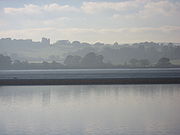
River Exe
Encyclopedia
Simonsbath
Simonsbath is a village high on Exmoor in the English county of Somerset. It is the principal settlement in the Exmoor civil parish, which is the largest and most sparsely populated civil parish on Exmoor, covering nearly but with a population, at the time of the 2001 census, of 203 in 78...
, on Exmoor
Exmoor
Exmoor is an area of hilly open moorland in west Somerset and north Devon in South West England, named after the main river that flows out of the district, the River Exe. The moor has given its name to a National Park, which includes the Brendon Hills, the East Lyn Valley, the Vale of Porlock and ...
in Somerset
Somerset
The ceremonial and non-metropolitan county of Somerset in South West England borders Bristol and Gloucestershire to the north, Wiltshire to the east, Dorset to the south-east, and Devon to the south-west. It is partly bounded to the north and west by the Bristol Channel and the estuary of the...
, near the Bristol Channel
Bristol Channel
The Bristol Channel is a major inlet in the island of Great Britain, separating South Wales from Devon and Somerset in South West England. It extends from the lower estuary of the River Severn to the North Atlantic Ocean...
coast, but flows more or less directly due south, so that most of its length lies in Devon
Devon
Devon is a large county in southwestern England. The county is sometimes referred to as Devonshire, although the term is rarely used inside the county itself as the county has never been officially "shired", it often indicates a traditional or historical context.The county shares borders with...
. It reaches the sea at a substantial ria
Ria
A ria is a coastal inlet formed by the partial submergence of an unglaciated river valley. It is a drowned river valley that remains open to the sea. Typically, rias have a dendritic, treelike outline although they can be straight and without significant branches. This pattern is inherited from the...
, the Exe Estuary
Exe Estuary
The Exe Estuary is an estuary on the south coast of Devon, England.The estuary starts just to the south of the city of Exeter, and extends south for approximately eight miles to meet the English Channel...
, on the south (English Channel
English Channel
The English Channel , often referred to simply as the Channel, is an arm of the Atlantic Ocean that separates southern England from northern France, and joins the North Sea to the Atlantic. It is about long and varies in width from at its widest to in the Strait of Dover...
) coast of Devon. Historically, its lowest bridging point was at Exeter
Exeter
Exeter is a historic city in Devon, England. It lies within the ceremonial county of Devon, of which it is the county town as well as the home of Devon County Council. Currently the administrative area has the status of a non-metropolitan district, and is therefore under the administration of the...
, though there is now a viaduct for the M5 motorway
M5 motorway
The M5 is a motorway in England. It runs from a junction with the M6 at West Bromwich near Birmingham to Exeter in Devon. Heading south-west, the M5 runs east of West Bromwich and west of Birmingham through Sandwell Valley...
about 3 kilometres (2 mi) south of the city centre.
Topography
The river's name derives from the Celtic word Isca meaning, simply, water. The river gives its name to the city of ExeterExeter
Exeter is a historic city in Devon, England. It lies within the ceremonial county of Devon, of which it is the county town as well as the home of Devon County Council. Currently the administrative area has the status of a non-metropolitan district, and is therefore under the administration of the...
and many other settlements along its course, including Exford
Exford, Somerset
Exford is a rural village at the centre of Exmoor, north-west of Dulverton, and south-west of Minehead, in Somerset, England. Less than a mile away is the hamlet of Lyncombe....
, Up Exe, Nether Exe
Nether Exe
Nether Exe or Netherexe is a very small village and civil parish in Devon, England. It lies near the River Exe, as its name suggests, about north of Exeter....
, Exwick
Exwick
Exwick is a suburb of Exeter, England, in the north-west of the City. Its name is derived from the River Exe, which forms its eastern boundary. It is also an Ecclesiastical parish and an electoral ward.-Population:...
, Exton
Exton, Somerset
Exton is a village and civil parish north-east of Dulverton and south-west of Dunster in Somerset, England. It lies on the River Exe on Exmoor...
, Exminster
Exminster
Exminster is a village situated on the southern edge of the City of Exeter on the western side of the Exeter ship canal and River Exe in the county of Devon, England. It is around south of the centre of Exeter, and has a population of 3,084 . Exminster is an ancient village associated with a Saxon...
, and Exebridge
Exebridge
Exebridge is a village that lies on the border between Devon and Somerset, England. It lies at the confluence of the Barle and Exe rivers. Exebridge is named so because of the bridge over the River Exe that also marks the border between Devon and Somerset. It is located at ....
, where it is joined by the River Barle
River Barle
The River Barle runs from the Chains on northern Exmoor, in Somerset, England to join the River Exe at Exebridge, Devon. The river and the Barle Valley are both designated as biological Site of Special Scientific Interest....
. The seaside town of Exmouth
Exmouth, Devon
Exmouth is a port town, civil parish and seaside resort in East Devon, England, sited on the east bank of the mouth of the River Exe. In 2001, it had a population of 32,972.-History:...
is at the east side of the estuary mouth, and Dawlish Warren
Dawlish Warren
Dawlish Warren is a small seaside resort near the town of Dawlish in Teignbridge on the south coast of Devon in England. Dawlish Warren consists almost entirely of holiday accommodation and facilities for holiday-makers especially caravan sites....
is at the west, with its long sand spit extending across the mouth.
The river fuelled Exeter's growth and relative importance in medieval times, and the city's first industrial area was developed at Exe Island
Exe Island
Exe Island was the early industrial area of Exeter, England, and was an area of marshland between the city walls and the river Exe, reclaimed by the construction of a series of leats, or water courses, possibly from as early as the 10th century. Of these, the Higher Leat still exists...
, created by a series of leat
Leat
A leat is the name, common in the south and west of England and in Wales, for an artificial watercourse or aqueduct dug into the ground, especially one supplying water to a watermill or its mill pond...
s to the west of the city. The island was home to numerous watermill
Watermill
A watermill is a structure that uses a water wheel or turbine to drive a mechanical process such as flour, lumber or textile production, or metal shaping .- History :...
s producing paper and textiles; it also created valuable land through drainage of the marshlands.
Tides on the river are limited at Countess Wear
Countess Wear
Countess Wear, alternatively called Countess Weir, is a residential district within the city of Exeter, in the English county of Devon. The name derives from the weir constructed in 1286 on the instruction of Isabella de Fortibus, Countess of Devon....
, the site of a weir
Weir
A weir is a small overflow dam used to alter the flow characteristics of a river or stream. In most cases weirs take the form of a barrier across the river that causes water to pool behind the structure , but allows water to flow over the top...
commissioned by the Countess of Devon
Isabella de Fortibus
Isabella de Fortibus was the eldest daughter of Baldwin de Redvers, 6th Earl of Devon. At the age of 11 or 12 she became the second wife of William de Fortibus who owned land in Yorkshire and Cumberland and was the count of Aumale in Normandy. When he died in 1260 part of his estates were...
in the 13th century. The Exeter Canal
Exeter Canal
The Exeter Ship Canal, sometimes just called the Exeter Canal, downstream of Exeter, Devon, England was built in the 1560s which means it pre-dates the "canal mania" period and is one of the oldest artificial waterways in the UK.-History:...
bypasses this weir to enable ships to reach Exeter Quay. At high tide, the estuary forms a large body of water that is heavily used for water sports especially sailing, windsurfing and water skiing.
Railways run along both sides of the estuary. The Avocet Line
Avocet Line
The Avocet Line is the railway line in England connecting Exeter with Exmouth. It was originally built by the London and South Western Railway. The line follows the Exe Estuary for most of its route, giving views of the estuary...
from Exeter to Exmouth on the eastern side, and the South Devon main line
South Devon Railway Company
The South Devon Railway Company built and operated the railway from Exeter to Plymouth and Torquay in Devon, England. It was a broad gauge railway built by Isambard Kingdom Brunel-Chronology:* 1844 South Devon Railway Act passed by parliament...
on the western. The latter is on a causeway, the South Devon Railway sea wall
South Devon Railway sea wall
The South Devon Railway sea wall is situated on the south coast of Devon in England. It is probably the most photographed section of railway in the United Kingdom as a footpath runs alongside the railway between Dawlish Warren and Dawlish, and another footpath forms a continuation to the sea front...
from Powderham to Dawlish Warren. The Exmouth to Starcross Ferry
Exmouth to Starcross Ferry
The Exmouth to Starcross Ferry is a passenger ferry which crosses the mouth of the River Exe in the English county of Devon. It links the town of Exmouth on the eastern side of the Exe estuary to the village of Starcross on the western side. The ferry is operated by Exe to Sea Cruises.The ferry...
carries passengers across the mouth of the estuary during the summer months, linking the harbour at Exmouth with a pier adjacent to Starcross railway station
Starcross railway station
Starcross railway station is a small station on the Exeter to Plymouth line in the village of Starcross, Devon, England. It is on the shore of the River Exe estuary and is linked to a pier used by the ferry to Exmouth on the other side of the estuary...
on the South Devon main line.
Wildlife
At low tide, extensive mud flats are exposed, and these are an important feeding source for wading birds. Along with other rias in South West EnglandSouth West England
South West England is one of the regions of England defined by the Government of the United Kingdom for statistical and other purposes. It is the largest such region in area, covering and comprising Bristol, Gloucestershire, Somerset, Dorset, Wiltshire, Devon, Cornwall and the Isles of Scilly. ...
, the Exe estuary is an important site for wintering waders. Dawlish Warren is a favoured site for birdwatching. The river is acidic and populated with wild brown trout
Brown trout
The brown trout and the sea trout are fish of the same species....
and some grayling
Grayling (species)
The grayling is a species of freshwater fish in the salmon family of order Salmoniformes. It is the type species of its genus. Native to the Palearctic ecozone, the grayling is widespread throughout northern Europe, from the United Kingdom and France to the Ural Mountains in Russia...
, the average size being 8–10 oz (226.8–283.5 g). Unlike many West Country rivers there are no seatrout, but there is a run of Atlantic salmon
Atlantic salmon
The Atlantic salmon is a species of fish in the family Salmonidae, which is found in the northern Atlantic Ocean and in rivers that flow into the north Atlantic and the north Pacific....
. Just 150 metres (492.1 ft) below the union of the River Barle is Black Pool, which is one of the best, and highest salmon pools on the river.
2008 cleansing operation
In 2008 the Environment AgencyEnvironment Agency
The Environment Agency is a British non-departmental public body of the Department for Environment, Food and Rural Affairs and an Assembly Government Sponsored Body of the Welsh Assembly Government that serves England and Wales.-Purpose:...
embarked on a project to clean the river from vegetation forming. In order to do so the water level decreased to its lowest level – less water remained than the droughts the city has suffered.