
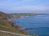
South Hams
Encyclopedia
South Hams is a local government district
on the south coast of Devon
, England
with its headquarters in the town of Totnes
. It contains the towns of Dartmouth
, Kingsbridge
, Ivybridge
, Salcombe
— the largest of which is Ivybridge with a population of 16,056.
To the north it includes part of Dartmoor National Park, to the east borders Torbay
, and to the west Plymouth
. It contains some of the most unspoilt coastline on the south coast, including the promontories of Start Point
, and Bolt Head
. The entire coastline, along with the lower Avon and Dart valleys, form most of the South Devon Area of Outstanding Natural Beauty
.
The South Hams, along with nearby Broadsands
in Paignton
, is the last British
refuge of the Cirl Bunting
.
(Celtic) Kingdom of Dumnonia
later reduced to the modern boundary at the River Tamar as Cornwall
presumably during the tenth century reign of Æthelstan. Post-Roman settlement on coastal promontory hillforts
, such as Burgh Island
, follows the established pattern of trading — of tin
in particular — found across the western, so-called 'Celtic', Atlantic coastal regions. In the later Anglo-Saxon era the South Hams was a feudal estate consisting of all of the land between the River Plym
and River Dart
and south of Dartmoor
with the English Channel
forming the southern boundary. There is some evidence that Cornish
was spoken and understood in the area until the late Middle Ages.
In 1917 the village of Hallsands was abandoned after much of it was lost to the sea. This happened because the shingle bank protecting the shore was removed to help build Devonport dockyard
.
In 1944 several villages were evacuated so that training for D-Day could be carried out in secret. The area was chosen because of the resemblance of its beaches to those of Normandy
. Preparations were disrupted, and secrecy nearly compromised, by a devastating E-boat attack during Exercise Tiger.
In 1967 the suburban towns of Plympton
and Plymstock
were amalgamated with the City of Plymouth
.
The current district was formed on 1 April 1974, under the Local Government Act 1972
, by the merger of:
Non-metropolitan district
Non-metropolitan districts, or colloquially shire districts, are a type of local government district in England. As created, they are sub-divisions of non-metropolitan counties in a so-called "two-tier" arrangement...
on the south coast of Devon
Devon
Devon is a large county in southwestern England. The county is sometimes referred to as Devonshire, although the term is rarely used inside the county itself as the county has never been officially "shired", it often indicates a traditional or historical context.The county shares borders with...
, England
England
England is a country that is part of the United Kingdom. It shares land borders with Scotland to the north and Wales to the west; the Irish Sea is to the north west, the Celtic Sea to the south west, with the North Sea to the east and the English Channel to the south separating it from continental...
with its headquarters in the town of Totnes
Totnes
Totnes is a market town and civil parish at the head of the estuary of the River Dart in Devon, England within the South Devon Area of Outstanding Natural Beauty...
. It contains the towns of Dartmouth
Dartmouth, Devon
Dartmouth is a town and civil parish in the English county of Devon. It is a tourist destination set on the banks of the estuary of the River Dart, which is a long narrow tidal ria that runs inland as far as Totnes...
, Kingsbridge
Kingsbridge
Kingsbridge is a market town and popular tourist hub in the South Hams district of Devon, England, with a population of about 5,800. It is situated at the northern end of the Kingsbridge Estuary, which is a textbook example of a ria and extends to the sea six miles south of the town.-History:The...
, Ivybridge
Ivybridge
Ivybridge is a small town and civil parish in the South Hams, in Devon, England. It lies about east of Plymouth. It is at the southern extremity of Dartmoor, a National Park of England and Wales and lies along the A38 "Devon Expressway" road...
, Salcombe
Salcombe
Salcombe is a town in the South Hams district of Devon, south west England. The town is close to the mouth of the Kingsbridge Estuary, built mostly on the steep west side of the estuary and lies within the South Devon Area of Outstanding Natural Beauty...
— the largest of which is Ivybridge with a population of 16,056.
To the north it includes part of Dartmoor National Park, to the east borders Torbay
Torbay
Torbay is an east-facing bay and natural harbour, at the western most end of Lyme Bay in the south-west of England, situated roughly midway between the cities of Exeter and Plymouth. Part of the ceremonial county of Devon, Torbay was made a unitary authority on 1 April 1998...
, and to the west Plymouth
Plymouth
Plymouth is a city and unitary authority area on the coast of Devon, England, about south-west of London. It is built between the mouths of the rivers Plym to the east and Tamar to the west, where they join Plymouth Sound...
. It contains some of the most unspoilt coastline on the south coast, including the promontories of Start Point
Start Point, Devon
Start Point is a promontory in the South Hams district. It is one of the most southerly points in Devon, England, . It marks the southern limit of Start Bay, which extends northwards to the estuary of the River Dart....
, and Bolt Head
Bolt Head
Bolt Head is a National Trust headland on the South Coast of Devon, Britain, situated west of the Kingsbridge Estuary.-External links:*...
. The entire coastline, along with the lower Avon and Dart valleys, form most of the South Devon Area of Outstanding Natural Beauty
South Devon Area of Outstanding Natural Beauty
The South Devon Area of Outstanding Natural Beauty covers 337 square kilometres, including much of the South Hams area of Devon and the rugged coastline from Jennycliff to Elberry Cove near Brixham. The purpose of an Area of Outstanding Natural Beauty is to preserve and enhance the beauty of...
.
The South Hams, along with nearby Broadsands
Broadsands
Broadsands is a beach in the Churston Ferrers part of Torbay in South Devon, England.It is a tourist attraction, with a large pitch and putt course. The beach is popular for fishing and watersports....
in Paignton
Paignton
Paignton is a coastal town in Devon in England. Together with Torquay and Brixham it forms the unitary authority of Torbay which was created in 1998. The Torbay area is a holiday destination known as the English Riviera. Paignton's population in the United Kingdom Census of 2001 was 48,251. It has...
, is the last British
Great Britain
Great Britain or Britain is an island situated to the northwest of Continental Europe. It is the ninth largest island in the world, and the largest European island, as well as the largest of the British Isles...
refuge of the Cirl Bunting
Cirl Bunting
The Cirl Bunting , Emberiza cirlus, is a passerine bird in the bunting family Emberizidae, a group now separated by most modern authors from the finches, Fringillidae....
.
History
The South Hams were originally part of the BrythonicBritons (historical)
The Britons were the Celtic people culturally dominating Great Britain from the Iron Age through the Early Middle Ages. They spoke the Insular Celtic language known as British or Brythonic...
(Celtic) Kingdom of Dumnonia
Dumnonia
Dumnonia is the Latinised name for the Brythonic kingdom in sub-Roman Britain between the late 4th and late 8th centuries, located in the farther parts of the south-west peninsula of Great Britain...
later reduced to the modern boundary at the River Tamar as Cornwall
Cornwall
Cornwall is a unitary authority and ceremonial county of England, within the United Kingdom. It is bordered to the north and west by the Celtic Sea, to the south by the English Channel, and to the east by the county of Devon, over the River Tamar. Cornwall has a population of , and covers an area of...
presumably during the tenth century reign of Æthelstan. Post-Roman settlement on coastal promontory hillforts
Hill fort
A hill fort is a type of earthworks used as a fortified refuge or defended settlement, located to exploit a rise in elevation for defensive advantage. They are typically European and of the Bronze and Iron Ages. Some were used in the post-Roman period...
, such as Burgh Island
Burgh Island
Burgh Island is a small tidal island off the coast of South Devon in England near to the small seaside village of Bigbury-on-Sea. There are several buildings on the island, the largest being the Art Deco Burgh Island Hotel...
, follows the established pattern of trading — of tin
Tin
Tin is a chemical element with the symbol Sn and atomic number 50. It is a main group metal in group 14 of the periodic table. Tin shows chemical similarity to both neighboring group 14 elements, germanium and lead and has two possible oxidation states, +2 and the slightly more stable +4...
in particular — found across the western, so-called 'Celtic', Atlantic coastal regions. In the later Anglo-Saxon era the South Hams was a feudal estate consisting of all of the land between the River Plym
River Plym
The River Plym is a river in Devon, England. Its source is some 450m above sea level on Dartmoor, in an upland marshy area called Plym Head. From the upper reaches which contain antiquities and mining remains the river flows roughly southwest and enters the sea near to the city of Plymouth, where...
and River Dart
River Dart
The River Dart is a river in Devon, England which rises high on Dartmoor, and releases to the sea at Dartmouth. Its valley and surrounding area is a place of great natural beauty.-Watercourse:...
and south of Dartmoor
Dartmoor
Dartmoor is an area of moorland in south Devon, England. Protected by National Park status, it covers .The granite upland dates from the Carboniferous period of geological history. The moorland is capped with many exposed granite hilltops known as tors, providing habitats for Dartmoor wildlife. The...
with the English Channel
English Channel
The English Channel , often referred to simply as the Channel, is an arm of the Atlantic Ocean that separates southern England from northern France, and joins the North Sea to the Atlantic. It is about long and varies in width from at its widest to in the Strait of Dover...
forming the southern boundary. There is some evidence that Cornish
Cornish language
Cornish is a Brythonic Celtic language and a recognised minority language of the United Kingdom. Along with Welsh and Breton, it is directly descended from the ancient British language spoken throughout much of Britain before the English language came to dominate...
was spoken and understood in the area until the late Middle Ages.
In 1917 the village of Hallsands was abandoned after much of it was lost to the sea. This happened because the shingle bank protecting the shore was removed to help build Devonport dockyard
HMNB Devonport
Her Majesty's Naval Base Devonport , is one of three operating bases in the United Kingdom for the Royal Navy . HMNB Devonport is located in Devonport, in the west of the city of Plymouth in Devon, England...
.
In 1944 several villages were evacuated so that training for D-Day could be carried out in secret. The area was chosen because of the resemblance of its beaches to those of Normandy
Normandy
Normandy is a geographical region corresponding to the former Duchy of Normandy. It is in France.The continental territory covers 30,627 km² and forms the preponderant part of Normandy and roughly 5% of the territory of France. It is divided for administrative purposes into two régions:...
. Preparations were disrupted, and secrecy nearly compromised, by a devastating E-boat attack during Exercise Tiger.
In 1967 the suburban towns of Plympton
Plympton
Plympton, or Plympton Maurice or Plympton St Maurice or Plympton St Mary or Plympton Erle, in south-western Devon, England is an ancient stannary town: an important trading centre in the past for locally mined tin, and a former seaport...
and Plymstock
Plymstock
Plymstock is a civil parish and commuter suburb of Plymouth in the English county of Devon.The earliest surviving documentary reference to the place is as Plemestocha in the Domesday Book and its name is derived from Old English meaning either "outlying farm with a plum-tree" or, if it is short for...
were amalgamated with the City of Plymouth
Plymouth
Plymouth is a city and unitary authority area on the coast of Devon, England, about south-west of London. It is built between the mouths of the rivers Plym to the east and Tamar to the west, where they join Plymouth Sound...
.
The current district was formed on 1 April 1974, under the Local Government Act 1972
Local Government Act 1972
The Local Government Act 1972 is an Act of Parliament in the United Kingdom that reformed local government in England and Wales on 1 April 1974....
, by the merger of:
- Borough of Dartmouth
- Borough of Totnes
- Kingsbridge Rural District
- Kingsbridge Urban District
- Plympton St Mary Rural District
- Salcombe Urban District
- Totnes Rural District
Settlements
- AshpringtonAshpringtonAshprington is a village and civil parish in the South Hams district of Devon, England. According to the 2001 census the parish had a population of 428. The village is not far from the River Dart, and is about three miles south of Totnes....
, Aveton GiffordAveton GiffordAveton Gifford is a small rural village in the south of the English county of Devon. It lies at the head of the estuary of the River Avon or Aune, at the point where it is crossed by the A379 road. It receives its name from this river and also from the family of Giffard who held the manor... - BanthamBanthamBantham is a village in Devon, England. It is in the South Hams district and lies on the estuary of the River Avon quarter of a mile from the sea at Bigbury Bay. It has a beach which is used by surfers....
, Berry PomeroyBerry PomeroyBerry Pomeroy is a village and civil parish in the South Hams district of Devon, England, about two miles east of Totnes. According to the 2001 census it had a population of 973...
, BickleighBickleigh, South HamsBickleigh is a small village on the southern edge of Dartmoor in Devon, England. It has a population of about 50 people. It is in the South Hams district, and is about seven miles north of Plymouth city centre...
, BigburyBigburyBigbury is a village and civil parish in the South Hams district of Devon, England. According to the 2001 census it had a population of 582.The parish council meets on the second Wednesday of every month at 7.30pm in Bigbury Memorial Hall...
, Bittaford, BlackawtonBlackawtonBlackawton is a village and civil parish in the South Hams district of Devon, England. According to the 2001 census it had a population of 647...
, BrixtonBrixton, DevonBrixton is a village near Plymouth in England. It is located on the A379 Plymouth to Kingsbridge road and is about from Plymouth. Its population is 1207.It has views of the River Yealm. The church is 15th century, with a tower arch 200 years older.**...
, BroadhempstonBroadhempstonBroadhempston is a small village within the Teignbridge District Council Area in the County of Devon in the South West of England . It comprises 257 houses with a population of 641....
, Buckland-Tout-SaintsBuckland-Tout-SaintsBuckland-Tout-Saints is a village and civil parish in the South Hams district of Devon, England. According to the 2001 census it had a population of 178.... - CharletonCharletonCharleton is a civil parish in the English county of Devon. In 2001 its population was 511.Forming part of the South Hams district its main settlements are East Charleton and West Charleton, the latter being the larger....
, ChillingtonChillington, DevonChillington is a village in the Stokenham civil parish of South Hams in Devon, England....
, Chivelstone, Churchstow, CornwoodCornwoodCornwood is a village and civil parish in the South Hams in Devon, England. It has a population of 988.- Religion :The Church of St Michael's is Cornwood's parish church....
, CornworthyCornworthyCornworthy is a village and civil parish in South Hams, Devon, England.The hamlet of East Cornworthy lies due east of the village at .Cornworthy Priory established for nuns of the order of St. Austin is now a Grade I listed building.-External links:* *... - DartingtonDartingtonDartington is a village in Devon, England. Its population is 1,917. It is located west of the River Dart, south of Dartington Hall and about two miles from Totnes...
, DartmouthDartmouth, DevonDartmouth is a town and civil parish in the English county of Devon. It is a tourist destination set on the banks of the estuary of the River Dart, which is a long narrow tidal ria that runs inland as far as Totnes...
, Dean PriorDean PriorDean Prior is a village and civil parish near the A38 road, in the South Hams district, in the county of Devon, England. It is located near the town of Buckfastleigh. Dean Prior has a church called St George Martyr, Dean Prior, where the seventeenth-century poet Robert Herrick was twice vicar.-...
, DiptfordDiptfordDiptford is a village in the county of Devon, England. It is perched on a hill overlooking the River Avon. The name is believed to come from "deep ford", referring to the local site of a river crossing....
, DittishamDittishamDittisham is a village and civil parish in the South Hams district of the English county of Devon. It is situated on the banks of the tidal River Dart, some upstream of Dartmouth....
, Dodbrooke - East AllingtonEast AllingtonEast Allington is a village in south Devon, England, three miles south of Halwell and just off the A381 road. It lies about three miles from Kingsbridge and about ten miles from Totnes. The coast at Slapton Sands is about five miles to the south-east. East Allington also includes the hamlet of The...
, East PortlemouthEast PortlemouthEast Portlemouth is a small Devon village situated at the southern end of the Kingsbridge Estuary. The village is sited on a hill giving views to the north to Kingsbridge and on a clear day as far as Dartmoor...
, ErmingtonErmington, DevonErmington is a village and civil parish located approximately south of the town of Ivybridge in the county of Devon, England. The village is in the South Hams district and is twinned with the commune of Clécy, in Normandy, France. It is known well for its crooked church spire, which a pub has been... - FrogmoreFrogmore, DevonFrogmore is a village in the civil parish of Frogmore and Sherford in the South Hams district of the county of Devon, England.The village is located at the head of Frogmore Creek, an arm of the Kingsbridge Estuary...
- HalwellHalwellHalwell is a small village located within the South Hams district council area, in Devon, South West England. It is located south of Totnes, and west of Dartmouth....
, HarbertonHarbertonHarberton is a village and civil parish 3 miles south west of Totnes, Devon, England, in South Hams District. The parish also includes the village of Harbertonford...
, HarfordHarford, DevonHarford is a hamlet and civil parish located approximately north of the town of Ivybridge in the county of Devon, England. The parish lies in the local government district of the South Hams, which is a localised, second-tier governmental division of the non-metropolitan county of Devon,...
, HolbetonHolbetonHolbeton is a village located 9 miles south east of Plymouth in Devon, UK. Historically it formed part of Ermington Hundred. To the east of the village is an Iron age enclosure or Hill fort known as Holbury...
, HolneHolneHolne is a village and civil parish on the southeastern slopes of Dartmoor in Devon, England. A community has existed here since at least the 11th century, and today a population of around 250 people is served by a church and a public house, the Church House Inn.-Village:The Church of St Mary the... - IvybridgeIvybridgeIvybridge is a small town and civil parish in the South Hams, in Devon, England. It lies about east of Plymouth. It is at the southern extremity of Dartmoor, a National Park of England and Wales and lies along the A38 "Devon Expressway" road...
- KingsbridgeKingsbridgeKingsbridge is a market town and popular tourist hub in the South Hams district of Devon, England, with a population of about 5,800. It is situated at the northern end of the Kingsbridge Estuary, which is a textbook example of a ria and extends to the sea six miles south of the town.-History:The...
, KingstonKingston, DevonKingston is civil parish and small scattered village in the South Hams, Devon, England. It is three miles south west of Modbury, and about a mile from the mouth of the River Erme at Wonwell. See the entry for Erme Mouth. In 2001 the population of the parish was 399. It has a small village hall -...
, KingswearKingswearKingswear is a village and civil parish in the South Hams area of the English county of Devon. The village is located on the east bank of the tidal River Dart, close to the river's mouth and opposite the small town of Dartmouth... - LittlehempstonLittlehempstonLittlehempston is a village and civil parish in the South Hams District of Devon in England. It has a population of 207.The village has many old fashioned cottages and buildings. Its church is on the hill within the village and is near to where a footpath begins, taking walkers through two miles...
, LoddiswellLoddiswellLoddiswell is a parish and village in the South Hams district of Devon, England. It lies on the west side of the River Avon or Aune and is three miles NNW from Kingsbridge. There is evidence of occupation going back to Roman times... - MalboroughMalboroughMalborough is a village located in the South Hams region of Devon. The village is located on the A381 between Kingsbridge and Salcombe, and is a popular village for tourists with many holiday homes located around the village....
, MarldonMarldonMarldon is a village in the South Hams in Devon, United Kingdom, lying just west of Paignton. It is the easternmost Civil Parish in the South Hams. Its population is about 2,300.-History:Church records date back to 1598...
, ModburyModburyModbury is a town and parish in the South Hams region of the English county of Devon. It is situated on the A379 road, which links it to Plymouth and Kingsbridge...
, Moreleigh - Newton FerrersNewton FerrersNewton Ferrers is a village in the civil parish of Newton and Noss in the English county of Devon, located about south-east of Plymouth on the River Yealm estuary. It lies within the South Devon Area of Outstanding Natural Beauty.-History:...
, North Huish - RatteryRatteryRattery is a village and civil parish in Devon, England, a few miles from Buckfastleigh, Ashburton, and Dartington. The name is often interpreted as a variant of "Red Tree" and is listed in the Domesday Book as Ratreu....
, Revelstoke, Ringmore - SalcombeSalcombeSalcombe is a town in the South Hams district of Devon, south west England. The town is close to the mouth of the Kingsbridge Estuary, built mostly on the steep west side of the estuary and lies within the South Devon Area of Outstanding Natural Beauty...
, Shaugh PriorShaugh PriorShaugh Prior is a village and civil parish on the south-western side of Dartmoor in the county of Devon, England. In 2001 its population was 751. The parish stretches from the edge of Plymouth to the high moorland of Dartmoor. The River Plym forms its western and northern boundaries up to the...
, SherfordSherfordSherford is a new town to be built in Devon, England. Development on the site started in 2007 and initial infrastructure work started in 2008. Its first 300 dwellings will be built in 2009 and when finished it will have 5,500 dwellings...
, SlaptonSlapton, DevonSlapton is a village in Devon, England. It is located near the A379 road between Kingsbridge and Dartmouth, and lies within the South Devon Area of Outstanding Natural Beauty . In 2001 the population of the civil parish of Slapton was 473...
, South BrentSouth BrentSouth Brent is a large village on the southern edge of Dartmoor, England, in the valley of the River Avon, population 2998 , 8 km north-east of Ivybridge, and next to the Devon Expressway which connects Exeter to the north-east and Plymouth to the west.-History:It was originally a woollen...
, South Huish, South Milton, South PoolSouth PoolSouth Pool is a village in the South Hams district of Devon, England.South Pool is located within South Hams local authority area. Historically it formed part of Coleridge Hundred. It falls within Woodleigh Deanery for ecclesiastical purposes. The Deaneries are used to arrange the typescript Church...
, SparkwellSparkwellSparkwell is a small Devon village in the South Hams local authority. It has a churchVicars of All Saints, Sparkwell1884-1911 Pender Hodge Cudlip1911-1947 Thomas Woodman1917-1924 Ernest Arthur Milne1924-1931 Edward Harold Smith...
, StavertonStaverton, DevonStaverton is a village and civil parish in the South Hams of Devon, England consisting 297 households and a population of 717 .The village has one pub/inn called 'The Sea Trout' which is located in the heart of the village....
, Stoke FlemingStoke FlemingStoke Fleming is a village and civil parish in the South Hams district of Devon, England. It lies on the A379 road about one and a half miles south of the town of Dartmouth, at the north end of Start Bay and within the South Devon Area of Outstanding Natural Beauty...
, Stoke Gabriel, StokenhamStokenhamStokenham is a village and civil parish in the English county of Devon.Stokenham civil parish includes the settlements of Torcross, Beesands, Hallsands, Kellaton, Kernborough, Dunstone, Beeson and Chillington as well as Stokenham itself. It forms part of the district of South Hams.To the east of... - ThurlestoneThurlestoneThurlestone is a village 5 miles west of Kingsbridge in the South Hams district in south Devon, England.The village takes its name from Thurlestone Rock, the so-called "thirled stone", an arch-shaped rock formation just offshore in Thurlestone Bay.The village's All Saints church is built of the...
, TorcrossTorcrossTorcross is a village in the South Hams district of Devon in England. It stands at grid reference at the southern end of Slapton Sands, a narrow strip of land and shingle beach which separates the freshwater lake of Slapton Ley from Start Bay and carries the A379 coastal road north to Dartmouth.-...
, TotnesTotnesTotnes is a market town and civil parish at the head of the estuary of the River Dart in Devon, England within the South Devon Area of Outstanding Natural Beauty... - UgboroughUgboroughUgborough is a village and civil parish in South Hams in the English county of Devon. It has a large church with a history going back to 1121. It also contains a Post Office, a small junior school and pre-school, a village hall and a central square. A public bus service runs through Ugborough, as...
- WemburyWemburyWembury is a village on the south coast of Devon, very close to Plymouth Sound. Wembury is also the name of the peninsula in which the village is situated. The village lies in the administrative district of the South Hams within the South Devon Area of Outstanding Natural Beauty . The South West...
, West AlvingtonWest AlvingtonWest Alvington is a small village, located on the outskirts of Kingsbridge in South Devon.It has a Primary School, and is about a 10 minute walk from the centre of Kingsbridge....
, Woodleigh - YealmptonYealmptonYealmpton is a village in the English county of Devon. It is located on the A379 Plymouth to Kingsbridge road and is about from Plymouth. It derives its name from the River Yealm that flows through the village. Yealmpton is home to a 400 year-old stone cottage, where it is said, a version of the...