

Somerset Levels
Encyclopedia
The Somerset Levels, or the Somerset Levels and Moors as they are less commonly but more correctly known, is a sparsely populated coastal plain
and wetland
area of central Somerset
, South West England
, between the Quantock
and Mendip Hills
. The Levels occupy an area of about 160000 acres (647.5 km²), corresponding broadly to the administrative district
of Sedgemoor
but also including the south-eastern part of the Mendip
district. The Somerset Levels are bisected by the Polden Hills
; the areas to the south are drained by the River Parrett
, and the areas to the North by the rivers Axe and Brue
. The Mendip Hills separate the Somerset Levels from the North Somerset Levels
. The Somerset Levels consist of marine clay
"levels" along the coast, and inland (often peat
-based) "moors"; agriculturally, about 70 percent is used as grassland and the rest is arable. Willow and teazel
are grown commercially and peat is extracted.
One explanation for the county of Somerset's name is that, in prehistory
, because of winter flooding humans restricted their use of the Levels to the summer, leading to a derivation from Sumorsaete, meaning land of the summer people. A Palaeolithic
flint tool found in West Sedgemoor is the earliest indication of human presence in the area. The Neolithic
people exploited the reedswamps for their natural resources and started to construct wooden trackway
s, including the world's oldest known timber trackway
, the Sweet Track
, dating from the 3800s BC
. The Levels were the location of the Glastonbury Lake Village
as well as two Lake villages at Meare Lake
. Several settlements and hill forts were built on the natural "islands" of slightly raised land, including Brent Knoll
and Glastonbury
. In the Roman
period sea salt
was extracted and a string of settlements were set up along the Polden Hills. The discovery at Shapwick
of 9,238 silver Roman coins
, known as the Shapwick Hoard
, was the second largest ever found from the time of the Roman Empire
. A number of Saxon
charters document the incorporation of areas of moor in estates. In 1685, the Battle of Sedgemoor
was fought in the Bussex area of Westonzoyland
at the conclusion of the Monmouth Rebellion
.
As a result of the wetland nature of the Moors and Levels, the area contains a rich biodiversity
of national and international importance. It supports a vast variety of plant and bird species and is an important feeding ground for birds. The Levels and Moors include 32 Sites of Special Scientific Interest
, of which 12 are also Special Protection Area
s. The area has been extensively studied for its biodiversity and heritage, and has a growing tourism industry.
People have been draining the area since before the Domesday Book
. In the Middle Ages, the monasteries of Glastonbury
, Athelney
, and Muchelney
were responsible for much of the drainage. The artificial Huntspill River
was constructed during the Second World War as a reservoir, although it also serves as a drainage channel. The Sowy River
between the River Parrett and King's Sedgemoor Drain was completed in 1972; water levels are managed by the Levels internal drainage board
s. During 2009 and 2010 proposals to build a series of electricity pylons by one of two routes between Hinkley Point
and Avonmouth
, to transmit
electricity from the proposed Hinkley Point C nuclear power station
, attracted local opposition. Discussions have taken place concerning the possibility of obtaining World Heritage Site
status for the Somerset Levels and Moors as a "cultural landscape". It was suggested that if this bid were successful it could improve flood control, but only if wetland fen
s were created again; the plans were abandoned in June 2010.
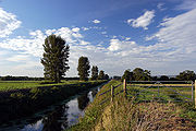
 The Levels and Moors are a largely flat area, with the "Moors" referring to the inland plains, and the "Levels" being a coastal sand and clay barrier, roughly west of the M5 motorway
. There are some slightly raised parts, called "burtles", as well as higher ridges and hills. The Levels are about 6 metres (20 ft) above mean sea level (O.D.
). The general elevation of the inland Moors is 3 to 3.7 m (9.8 to 12.1 ft) O.D. and with peak tides of 7.6 to 7.9 m (24.9 to 25.9 ft) O.D. recorded at Bridgwater and Burnham-on-Sea, respectively, the Moors lie below peak tides. Large areas of peat
were laid down in the Moors, particularly in the Brue Valley, during the Quaternary
period after the ice sheets melted. The area's topography
consists of two basins mainly surrounded by hills, the runoff from which forms rivers that originally meandered across the plain but have now been controlled by embanking and clyses (the local name for a sluice). The area is prone to winter floods of fresh water and occasional salt water inundations. The worst in recorded history was the Bristol Channel floods of 1607
, which resulted in the drowning of an estimated 2,000 or more people, houses and villages swept away, an estimated 200 square miles (518 km²) of farmland inundated, and livestock destroyed. Another severe flood occurred in 1872–1873, when over 107 square miles (277 km²) were underwater from October to March.
Although underlain by much older Triassic
age formations that protrude to form what would once have been islands—such as Athelney
, Brent Knoll
, Burrow Mump
and Glastonbury Tor
—the lowland landscape was formed only during the last 10,000 years, following the end of the last ice age
. Glastonbury Tor is composed of Upper Lias
Sand. The Poldens
and the Isle of Wedmore
are composed of Blue Lias
and Marl
, while the Mendips
are largely Carboniferous limestone
. Although sea level changes since the Pliocene
led to changes in sea level and the laying down of vegetation, the peak of the peat formation took place in swamp
conditions around 6,000 years ago, although in some areas it continued into medieval times.
It is a mainly agricultural region, typically with open fields of permanent grass surrounded by ditches with willow
trees. Access to individual areas of the Moors and Levels, especially for cattle, was provided by means of "droves", i.e. green lanes, leading off the public highways. Some of the old roads, in contrast to the old hollow ways
found in other areas of England, are causeway
s raised above the level of the surrounding land, with a drainage ditch running along each side.
>
Most of the settlements on the Levels are small villages. In the southern area the civil parish of Aller
, which has a population of 374, includes the hamlet
of Beer (sometimes Bere) and the deserted medieval village
of Oath on the opposite bank of the River Parrett. The area known as the Isle of Athelney
was once a very low isolated island linked by a causeway to East Lyng
, each end of which was protected by a semi-circular stockade
and ditch. The ditch on the island is now known to date from the Iron Age
, and was used by Alfred the Great
as a fort before the Battle of Ethandun in May 878; in gratitude for his victory Alfred founded a monastery
, Athelney Abbey
, on the Isle in 888, which survived until the Dissolution of the Monasteries
under Henry VIII
in 1539. Bawdrip
is a small village which has a population of 498. Brent Knoll
is a large village at the foot of a 137 metres (449.5 ft) hill
that dominates the surrounding landscape; the name means Beacon Hill in Old English. Brent Knoll has been inhabited since at least the Bronze Age
. Before the Somerset Levels were drained, Brent Knoll was an island known as the Isle (or Mount) of Frogs.
Glastonbury
(population 8,784) and Street
(11,066) lie on opposite sides of the River Brue
, and provide a central point for trade and commerce. Larger centres are generally on slightly higher ground around the edges of the Levels. Bridgwater
is a market town
, the administrative centre of the Sedgemoor
district, and a major industrial centre. With a population of 33,698, it straddles the major communication routes through South West England
. Situated on the edge of the Somerset Levels, along both banks of the River Parrett and 10 miles (16 km) from its mouth, it was at one time a major port and trading centre. The hamlet of Dunball
forms part of the port on the river. Burrowbridge
lies on the River Parrett further inland. The name probably comes from the Old English buruh (fortified hill) and brycg (bridge). In the village is Burrow Mump
, an ancient earthwork now owned by the National Trust
. Burrow Mump is also known as St Michael's Borough or Tutteyate. It is a natural hill of Triassic
sandstone
capped by Keuper marl
. Excavations showed evidence of a medieval masonry building on the top of the hill.
Along the coast, settlements such as Berrow
are built on the line of sand dunes separating the low-lying marshes from the Bristol Channel. At the northern end Bleadon
lies on the River Axe; and there was for many years a small harbour, sometimes known as Lympsham Wharf. The arrival of the Bristol and Exeter Railway
in 1841, which crossed the Axe on a bridge, obstructed river traffic beyond the wharf, making it the limit of navigation for coastal vessels. An Act
of 1915 authorised the drainage of the river and installation of a flood gate at Bleadon, although attempts to control the water had occurred on Bleadon Level since medieval times, including an early windmill
, in 1613, to pump water into the sea from behind a sea wall. Burnham-on-Sea
(population 18,401) is at the mouth of the River Parrett where it enters Bridgwater Bay
. The position of the town on the edge of the Somerset Levels has resulted in a history dominated by land reclamation and sea defences since Roman
times. Burnham was seriously affected by the Bristol Channel floods of 1607
, and various flood defences have been installed since then. A concrete sea wall was built in 1911, and after the Second World War further additions to the defences were made, using the remains of a Mulberry harbour
; the present curved concrete wall was completed in 1988. Highbridge
, which neighbours Burnham, is near the mouth of the River Brue and the villages of East and West Huntspill
.
the Somerset Levels have a temperate climate, which is generally wetter and milder than the rest of the country. The annual mean temperature is approximately 10 °C (50 °F). Seasonal temperature variation is less extreme than most of the United Kingdom because of the adjacent sea. The summer months of July and August are the warmest, with mean daily maxima of approximately 21 °C (69.8 °F). In winter, mean minimum temperatures of 1 or are common. The Azores high pressure area
influences the south-west of England's summer weather, but convective
cloud sometimes forms inland, reducing the number of hours of sunshine. Annual sunshine rates are slightly less than the regional average of 1,600 hours. In December 1998, there were 20 days without sun recorded at Yeovilton
. Most rainfall in the south-west is caused by convection
or Atlantic depressions, which are most active in autumn and winter, when they are the chief cause of rain. In summer, a large proportion of the rainfall is caused by the Sun heating the land, leading to convection and to showers and thunderstorms. Average rainfall is around 700 mm (27.6 in), and about 8–15 days of snowfall is typical. November to March have the highest mean wind speeds, and June to August have the lightest winds. The predominant wind direction is from the southwest.
 The Moors and Levels are formed from a submerged and reclaimed landscape. Early attempts to control the water levels were possibly made by the Romans (although records only date from the 13th century), but were not widespread.
There was a port at Bleadney on the River Axe in the 8th century which allowed goods to be brought to within 3 miles (5 km) of Wells
. In 1200, a wharf was constructed at Rackley near Axbridge
. The Parrett was navigable up as far as Langport
in 1600, with 15 to 20 ton barges. The Domesday Book
recorded that drainage of the higher grounds was under way, although the moors at Wedmoor were said to be useless. In the Middle Ages, the monasteries of Glastonbury
, Athelney
, and Muchelney
were responsible for much of the drainage. In 1129, the Abbot of Glastonbury was recorded as inspecting enclosed land at Lympsham
. Efforts to control flooding on the Parrett
were recorded around the same date. In 1234, 722 acres (2.9 km²) were reclaimed near Westonzoyland
and, from the accounts in the abbey's rent books, this had increased to 972 acres (393.4 ha) by 1240. Flooding of adjacent moor land was partially addressed during the 13th century by the construction of a number of embankment walls to contain the Parrett. They included Southlake Wall, Burrow Wall, and Lake Wall. The River Tone was also diverted by the Abbot of Athelney and other land owners into a new embanked channel, joining the Parrett upstream from its original confluence.
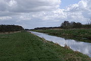
 The main drainage outlets flowing through the Moors and Levels are the rivers Axe, Brue
, Huntspill
, Parrett
, Tone
, and Yeo
, together with the King's Sedgemoor Drain
, an artificial channel into which the River Cary
now runs. Previously, the Cary ran into the Tone while the Brue ran through Meare Pool
(now drained) and the Panborough Gap, and then into the Axe. Another accomplishment in the Middle Ages was the construction of the tidal Pillrow Cut, joining the Brue and Axe. In 1500, there was said to be 70000 acres (283 km²) of floodable land of which only 20000 acres (81 km²) had been reclaimed. In 1597, 50 acres (20.2 ha) of land were recovered near the Parrett estuary; a few years later, 140 acres (56.7 ha) near Pawlett were recovered by means of embankments; and three further reclamations, totalling 110 acres (44.5 ha), had been undertaken downstream of Bridgwater by 1660.
In the early 17th century, during the time of King James I, abortive plans were made to drain and enclose much of Sedgemoor
, which the local Lords supported but opposed by the Commoners who would have lost grazing rights. In 1632, Charles I
sold the Crown's interest in the scheme, and it was taken over by a consortium that included Sir Cornelius Vermuyden
, a Dutch
drainage engineer. However, the work was delayed by the English Civil War
and later defeated in parliament after local opposition. In 1638, it was reported that nearly 2600 acres (11 km²) of Tealham and Tadham Moors
were not reclaimed, with a total of 30500 acres (123.43 km²) being undrained. Between 1785 and 1791, much of the lowest part of the peat moors was enclosed. In 1795, John Billingsley
advocated enclosure and the digging of rhyne
s (a local name for drainage channels, pronounced "reens" in the east and rhyne to the west) between plots, and wrote in his Agriculture of the County of Somerset that 4400 acres (18 km²) had been enclosed in the last 20 years in Wedmore
and Meare
, 350 acres (1.4 km²) at Nyland, 900 acres (3.64 km²) at Blackford, 2000 acres (8 km²) at Mark
, 100 acre (0.404686 km²) in Shapwick
, and 1700 acres (7 km²) at Westhay
. At Westhay Moor
in the early 19th century, it was shown how peat bogs could be successfully drained and top-dressed with silt deposited via flooding, creating a very rich soil. The character of the soil was also changed by the spreading of clay and silt from the digging of King's Sedgemoor Drain.
Little attempt was made during the 17th and 18th centuries to pump water, possibly because the coal-driven Newcomen steam engine
s would have been uneconomical. It is unclear why windmill
s were not employed, as they were onThe Fens
of East Anglia
, but only two examples have been recorded on the Levels: one at Bleadon
at the mouth of the River Axe, where a sea wall had been built, and the other at Common Moor north of Glastonbury, which was being drained following a private Act of Parliament in 1721. The first steam pumping station was Westonzoyland Pumping Station
in 1830, followed by more effective ones from 1860. Automatic electric pumps are used today.
 The man-made Huntspill River
was constructed during the Second World War with sluices at both ends to provide a guaranteed daily supply of 4500000 gallons (20,457,405 l) of "process water". It was intended that in the summer, when water supply was lower, it would serve as a reservoir with water pumped from the moors; and in winter serve as a drainage channel, via gravity drainage. Geotechnical
problems prevented it from being dug as deep as originally intended and so gravity-drainage of the moors was not possible: thus, water is pumped up into the river throughout the year. The Sowy River
between the River Parrett and King's Sedgemoor Drain was completed in 1972. The Levels and Moors are now artificially drained by a network of rhynes which are pumped up into "drains". Water levels are managed by the Levels internal drainage board
s (IDBs); the Levels are not as intensively drained or farmed as the East Anglia
n fen
s, historically a similar area of low marsh. They are still liable to widespread fresh water flooding in winter. One of the approaches to reducing the risk of flooding within the catchment area of the Parrett is the planting of new woodlands.
Controversy about the management of the drainage and flood protection has previously involved the activities of IDB's. However, IDB's have been actively participating with the Parrett Catchment Partnership, a partnership of 30 organisations that aims to create a consensus on how water is to be managed, in particular, looking at new ways to achieve sustainable benefits for all local stakeholders.
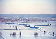
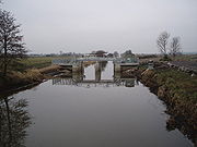
During 2009 and 2010, work was undertaken to upgrade sluice gates, watercourses, and culverts to enable seasonal flooding of Southlake Moor
during the winter diverting water from the Sowy River
onto the moor. It has the capacity to hold 1.2 million cubic metres as part of a scheme by the Parrett Internal Drainage Board to restore ten floodplains in Somerset. In spring, the water is drained away to enable the land to be used as pasture during the summer. The scheme is also used to encourage water birds.
 The Somerset Levels consist of a coastal clay belt only slightly above mean sea level, with an inland peat belt at a lower level behind it. Thus, the Levels are at risk from both tidal and land-based flood waters. They were frequently flooded by the sea during high tides, a problem that was not resolved until the sea defences
were enhanced in the early 20th century. In addition, the problems of high fresh water floods are aggravated by the unrestricted entry of the tide along the Parrett
, which is the only river in the Levels and Moors that does not have a clyse on it. Discussions on whether a clyse is needed for the Parrett and whether it should be sited at Bridgwater or nearer the mouth of the river date back to 1939, at start of Second World War, and have not been resolved. The Environment Agency
's current "Parrett Catchment Flood Management Plan", published December 2009, divides the Parrett catchment area into eight sub-areas, with the Somerset Levels and Moors falling into sub-area 6 and Bridgwater falling into sub-area 7. As part of the published flood risk assessments for both these sub-areas, it is recognised that: at a future date a tidal clyse may be needed on the Parrett; this causes a funding dilemma; and, geomorphology
studies of the Parrett and the Tone
are needed to help address many of the uncertainties associated with a tidal exclusion project.
During the great storm of 1703, waves came four feet (1.2 m) over the sea walls. The sea wall was again breached in 1799, filling the Axe valley with sea water. In 1872, another flood covered 7000 acres (28 km²) and in 1919, 70000 acres (283 km²) were inundated with sea water, poisoning the land for up to 7 years. Since 1990, the drainage board has been charged with looking at the rhyne
s, cleaning them out and keeping them clear, under the overall responsibility of the Environment Agency. With rising sea levels, the work required to maintain the sea defences is likely to become more expensive, and it has been proposed that two inland seas be created. Other studies have recommended maintaining the current defences for five years while undertaking further studies of available options.
people to occupy seasonal camps on the higher ground, indicated by scatters of flints. Subsequent winter flooding probably led to humans in prehistory
only using the Levels in the summer, hence the county of Somerset may derive its name from Sumorsaete, meaning land of the summer people. An alternative suggestion is that the name derives from Seo-mere-saetan meaning "settlers by the sea lakes". The Neolithic
people continued to exploit the reedswamps for their natural resources and started to construct wooden trackway
s such as the Sweet
and Post Track
s. The Sweet Track, named after the peat digger who discovered it in 1970 and dating from the 3800s BC
, is the world's oldest timber trackway
, once thought to be the world's oldest engineered roadway. The track was built between what was in the early 4th millennium BC an island at Westhay
and a ridge of high ground at Shapwick
, close to the River Brue
. The remains of similar tracks have been uncovered nearby, connecting settlements on the peat bog including the Honeygore, Abbotts Way, Bells, Bakers, Westhay, and Nidons trackways.
The Levels contain the best-preserved prehistoric village in the UK, Glastonbury Lake Village
, as well as two others at Meare Lake Village
. Discovered in 1892 by Arthur Bulleid, it was inhabited by about 200 people living in 14 roundhouses
, and was built on a morass
on an artificial foundation of timber filled with brushwood, bracken
, rubble and clay. Investigation of the Meare Pool indicates that it was formed by the encroachment of raised peat bogs, particularly during the Subatlantic climatic period (1st millennium BC
), and core sampling
demonstrates that it is filled with at least 2 metres (6.6 ft) of detritus mud.
The two villages within Meare Pool appear to originate from a collection of structures erected on the surface of the dried peat, such as tents, windbreaks and animal folds. Clay was later spread over the peat, providing raised stands for occupation, industry and movement, and in some areas thicker clay spreads accommodated hearths built of clay or stone.
The area continued to be inhabited during the Bronze Age
, when the population supported itself largely by hunting and fishing in the surrounding marshes, living on artificial islands connected by wooden causeway
s on wooden piles. There have been many finds of metalwork during peat cutting, which may have been devotional offerings. Brent Knoll
has been settled by humans since at least the Bronze Age. It is the site of an Iron Age
hill fort
known as Brent Knoll Camp
, with multiple ramparts (multivallate) following the contours of the hill. Several settlements and hill forts were built on the natural "islands" of slightly raised land, including Brent Knoll, Glastonbury
, and the low range of the Polden Hills
. According to legend Ider son of Nuth, who was one of King Arthur's
knights, went to the Mount of Frogs on a quest to slay three giants who lived there. The fort has been claimed as the site of the Battle of Mons Badonicus
.
Sea salt
was extracted during the Roman
period, and a string of settlements were set up along the Polden Hills. Some possible settlement sites are also known in the Draycott and Cheddar Moors and around Highbridge
. The discovery at Shapwick
of 9,238 silver Roman coins
, the second largest hoard
ever found from the Roman Empire
included coins dated from as early as 31–30 BC up until 224 AD. The hoard also contained two rare coins which had not been discovered in Britain before, and the largest number of silver denarii
ever found in Britain.
A number of Saxon
charters document the incorporation of areas of moor in estates, suggested that the area continued to be exploited. It is easy to see why the area acquired a number of legends, particularly of King Arthur
and his followers, who some believe based his court in the hill fort at South Cadbury
. According to legend, Alfred the Great
burnt cakes when hiding in the marshes of Athelney
, after the Danish
invasion in 875. After the battle of Edington the Danish king was baptised at Aller
and a peace treaty signed at Wedmore
.
In 1685, the Monmouth Rebellion
ended at the Battle of Sedgemoor
, which was fought in the Bussex area of Westonzoyland
.
trees. The landscape is dominated by grassland, mostly used as pasture for dairy farming with approximately 70 percent of the area being grassland and 30 percent arable. From January until May, the River Parrett
provides a source of European eel
s (Anguilla anguilla) and young elvers, which are caught by hand net
ting as this is the only legal means of catching them. A series of eel passes have been built on the Parrett at the King's Sedgemoor Drain to help this endangered species; cameras have shown 10,000 eels migrating upstream in a single night. The 2003 BBC Radio 4
play Glass Eels
by Nell Leyshon
was set on the Parrett.
The Levels and Moors, as part of the West Country, was a traditional producer of cider
, with individual farms having orchard
s and producing their own cider, known as scrumpy
. However, over 60% of Somerset's orchards have been lost in the last fifty years; and apple production occupies less than 0.4% of the land. Cider is still produced in Somerset by Thatchers Cider and Gaymer Cider Company
. Other local industries that once thrived on the Levels, such as thatching (using reeds) and basket making (using willow), have been in decline since the second half of the 20th century. Combined with the recent drop in farm incomes, this poses a potential threat to the "traditional" nature of the area as a whole. Subsidies are paid to farmers who manage their land in the traditional way.
In October 2009, National Grid began public consultations over plans to build a line of electricity pylons, by one of two routes between Hinkley Point
and Avonmouth
. The plans attracted local opposition. The first consultation process ended in January 2010. They had proposed that each pylon would be 46 metres (150.9 ft) high: the consultation was only in respect of preferences between two alternate routes, not the size nor the use of large pylons. The proposed line, which is due to open by September 2017, will transmit
400 Kilovolts
of electricity from the proposed Hinkley Point C nuclear power station
. Électricité de France
has begun public consultations in respect of the local infrastructure needed for the construction programme to build Hinkley Point C; but, as of January 2011, has not submitted applications for consents for the proposed power stations. It has, however, submitted a planning application for preliminary site preparation works, which it states that it will undo should consents for the power stations be refused.
In 2010 and 2011, two proposals to build a total of 14 wind turbine
s, with Ecotricity
to build five or four adjacent to the M5 Motorway near Brent Knoll
and Électricité de France to build nine at East Huntspill, are opposed by local groups on the grounds of their effect on the local environment and potential damage to the bird population.
 Willow has been cut and used on the Levels since humans moved into the area. Fragments of willow basket were found near the Glastonbury Lake Village, and it was used in the construction of several Iron Age
causeways. The willow was harvested using traditional methods of pollarding
, where a tree would be cut back to the main stem. New shoots of willow, called "withies", would grow out of the trunk and these would be cut periodically for use.
During the 1930s, over 9000 acres (36 km²) of willow were being grown commercially on the Levels. Largely because of the replacement of baskets by plastic bags and cardboard boxes, the industry has severely declined since the 1950s. By the end of the 20th century only about 350 acres (1.4 km²) were grown commercially, near the villages of Burrowbridge
, Westonzoyland
, and North Curry
. The Somerset Levels is now the only area in the UK where basket willow is grown commercially. For weaving, the species Salix triandra
(Almond Willow, Black Maul) is grown, while Salix viminalis (Common Osier) is ideal for handles, bases, and the structural members in furniture and hurdles. Historically willow was used to make salmon traps or "putcher
s". Products including baskets, eel traps (kypes), lobster pots
, and furniture were widely made from willow throughout the area in the recent past. Among the more unusual products still made are passenger baskets for hot air balloon
s, the frames inside the Bearskin hats
worn by the regiments of the Grenadier Guards
, and an increasing number of willow coffin
s.
Another use of willow has been found by the Coate family, who make artist's charcoals in Stoke St Gregory
. It has become in 30 years the leading artists' charcoal manufacturer in Europe, producing most of the natural charcoals sold under different art-material brands.
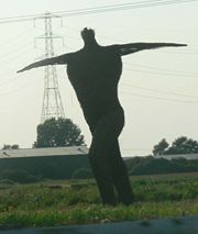
The industry is celebrated in the form of the Willow Man
(sometimes known as the Angel of the South), a willow sculpture, 40 feet (12.2 m) tall, produced by artist Serena de la Hey in September 2000 that can be seen from the railway and the M5 motorway
to the north of Bridgwater
. At Stoke St Gregory
there is also a Willows and Wetlands Visitor Centre
.
around the River Isle
near Chard
on the heavy clay soils around Fivehead
. These are used to provide a fine finish on worsted
s and snooker table cloths.
from the Moors is known to have taken place during Roman
times, and has been carried out since the Levels were first drained. The introduction of plastic packaging in the 1950s allowed the peat to be packed without rotting, which led to the industrialisation of peat extraction during the 1960s as a major market in horticultural
peat was developed. The reduction in water levels that resulted put local ecosystem
s at risk; peat wastage in pasture fields was occurring at rates of 1–3 feet (0.3–0.8 m) over 100 years. Peat extraction continues today, although much reduced.
 As a result of their wetland
nature, the Moors and Levels contain a rich biodiversity
of national and international importance. They support a vast variety of plant species, including common plants such as Marsh Marigold
, Meadowsweet, and Ragged Robin. The area is an important feeding ground for birds including Bewick’s Swan, Eurasian Curlew
, Common Redshank
, Skylark
, Common Snipe
, Common Teal, Wigeon
, and Whimbrel
, as well as birds of prey including the Marsh Harrier
and Peregrine Falcon
. A wide range of insect species is also present, including rare invertebrate
s, particularly beetles including the Lesser silver water beetle
, Bagous nodulosus, Hydrophilus piceus, Odontomyia angulata, Oulema erichsoni, and Valvata macrostoma
. In addition, the area supports an important Otter
population. Water Voles (Arvicola amphibius) are being encouraged to recolonise areas of the Levels where they have been absent for 10 years, by the capture of Mink
(Mustela vison).
In 2010, a project was started to reintroduce the Common Crane
to the Levels, after an absence of 400 years. The birds' eggs were flown from Germany to the Slimbridge wetland reserve
managed by the Wildfowl and Wetlands Trust (a UK charity) at Slimbridge
, Gloucestershire
, and reared to the age of five months before being released onto the Levels. The "Great Crane Project" aims to introduce around 20 of the birds each year until 2015. The work, which included collaboration with Pensthorpe Nature Reserve
and the Royal Society for the Protection of Birds
, was supported by a grant of £700k from Viridor Credits.
The Levels and Moors contain 32 Sites of Special Scientific Interest
(12 of them also Special Protection Area
s), the River Huntspill
and Bridgwater Bay
National Nature Reserves
, the Somerset Levels and Moors Ramsar Site
covering about 86000 acres (348 km²), the Somerset Levels National Nature Reserve, Shapwick Heath National Nature Reserve
, Ham Wall
National Nature Reserve and numerous Scheduled monuments. The Brue Valley Living Landscape
conservation
project commenced in January 2009 and aims to restore, recreate and reconnect habitat
. It aims to ensure that wildlife is enhanced and capable of sustaining itself in the face of climate change
while guaranteeing farmers and other landowners can continue to use their land profitably. It is one of an increasing number of landscape scale conservation
projects in the UK. About 72000 acres (291 km²) of the Levels are recognised as an Environmentally Sensitive Area
, and other areas are designated as Areas of High Archaeological Potential
, but there is currently no single conservation designation
covering the Levels and Moors.
A survey in 2005 discovered that 11 of the known wooden Bronze Age causeways on the Levels had been destroyed or vanished and others were seriously damaged, caused by the reduction in water levels and subsequent exposure of the timber to oxygen and aerobic bacteria
. Part of the Sweet Track is being actively conserved. Following purchase of land by the National Heritage Memorial Fund
, and installation of a water pumping and distribution system along a 500 metres (1,640.4 ft) section, several hundred metres of the track's length are now being actively conserved. This method of preserving wetland archaeological remains (i.e. maintaining a high water table and saturating the site) is rare. A 500 metres (1,640.4 ft) section, which lies within the land owned by the Nature Conservancy Council
, has been surrounded by a clay bank to prevent drainage into surrounding lower peat fields, and water levels are regularly monitored. The viability of this method is demonstrated by comparing it with the nearby Abbot's Way, which has not had similar treatment, and which in 1996 was found to have become dewatered and desiccated. Evaluation and maintenance of water levels in the Shapwick Heath Nature Reserve involves the Nature Conservancy Council, the Department for Environment, Food and Rural Affairs
, and the Somerset Levels Project.
began a research project that resulted in the publication of an important series of papers on many aspects of the Levels. A range of archaeological projects, such as the exploration of various trackways from the 3rd and 1st millennia BC and the establishment of their economic and geographic significance, was funded by various donors including English Heritage
. Possibly the project's most significant excavation was of the Sweet Track in 1970, during which a Jadeite
axe was discovered. Eight radiocarbon
determinations of the date of the axe place it at around 3200 BC.
The work of John Coles and the Somerset Levels Project was recognised in 1996 when they won the ICI Award for the best archaeological project offering a major contribution to knowledge, and in 2006 with the award of the European Archaeological Heritage Prize.
, was begun by Mick Aston
of Bristol University
to investigate the evolution of a typical English village. A preliminary study of the village's history was carried out using maps and documents, then surveys of the buildings were made together with botanical surveys. Field walking was carried out and key sites excavated. A report on the project, which ran from 1989 to 1999, was published in eight volumes.
 Being largely flat, the Levels are well suited to bicycle
s, and a number of cycle routes
exist including the Withy Way Cycle Route (22 mi (35.4 km)), Avalon Marshes Cycle Route (28 mi (45.1 km)), Peat Moors Cycle Route (24 mi (38.6 km)) and the Isle Valley Cycle Route (28 mi (45.1 km)). The River Parrett Trail
(47 mi (75.6 km)) and Monarch's Way
long-distance footpaths
are also within the area.
Visitors' centres aim to convey various aspects of the Levels. The Willows and Wetlands Visitor Centre
near Stoke St Gregory
offers tours of the willow yards and basket workshops and explains the place of willow in the history of the Levels. The Somerset Willow Company also allows visitors into its workshops. The Peat Moors Centre
to the west of Glastonbury
was dedicated to the archaeology
, history and geology of the area. It also included reconstructions of some of the archaeological discoveries, including a number of Iron Age round houses and the world's oldest engineered highway, the Sweet Track
. From time to time the centre offered courses in a number of ancient technologies in subjects including textiles, clothing and basket making, as well as staging various open days, displays and demonstrations. In February 2009 Somerset County Council
, the owners of the Peat Moors Centre, announced their intention of closing the centre and it finally shut on 31 October 2009.
The Tribunal
in Glastonbury, a medieval
merchant's house, contains possessions and works of art from the Glastonbury Lake Village
, which were preserved in almost perfect condition in the peat after the village was abandoned. It also houses the tourist information centre
. Also in Glastonbury, the Somerset Rural Life Museum
is a museum of the social and agricultural history of Somerset, housed in buildings surrounding a 14th–century barn once belonging to Glastonbury Abbey
. It was used as a tithe barn
for the storage of arable
produce, particularly wheat
and rye
, from the abbey's home farm of approximately 524 acres (2.1 km²). Threshing
and winnowing would also have been carried out in the barn. The barn which was built from local "shelly" limestone, with thick timbers supporting the stone tiling of the roof. It has been designated by English Heritage
as a grade I listed building, and is a Scheduled monument. The barn and courtyard contain displays of farm machinery from the Victorian
and early 20th-century periods. Other exhibits show local crafts, including willow
coppicing
, mud horse fishing on the flats of Bridgwater Bay
, peat
digging on the Somerset Levels, and the production of milk, cheese, and cider. In reconstructed rooms detailing domestic life in the nearby village of Butleigh
, the story of one farm worker, John Hodges, is told from cradle to grave. Outside, there is a beehive
and rare breeds of poultry and sheep in the cider apple orchard.
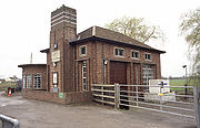
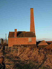
The Langport & River Parrett Visitor Centre at Langport
details local life, history, and wildlife. The Westonzoyland Pumping Station Museum
, near the town on the River Parrett, is housed in one of the earliest steam-powered
pumping stations on the Levels, dating from the 1830s; it was closed in the 1950s. Featuring several steam engines, some built locally, the museum holds a number of live steam days each year. The pump house has been Grade II* listed, and is on English Heritage
's Buildings at Risk Register.
As of 2009, the tourist authorities in the area were seeking to establish the term "Avalon Marshes" as the new name of the Somerset Moors.
Coastal plain
A coastal plain is an area of flat, low-lying land adjacent to a seacoast and separated from the interior by other features. One of the world's longest coastal plains is located in eastern South America. The southwestern coastal plain of North America is notable for its species diversity...
and wetland
Wetland
A wetland is an area of land whose soil is saturated with water either permanently or seasonally. Wetlands are categorised by their characteristic vegetation, which is adapted to these unique soil conditions....
area of central Somerset
Somerset
The ceremonial and non-metropolitan county of Somerset in South West England borders Bristol and Gloucestershire to the north, Wiltshire to the east, Dorset to the south-east, and Devon to the south-west. It is partly bounded to the north and west by the Bristol Channel and the estuary of the...
, South West England
South West England
South West England is one of the regions of England defined by the Government of the United Kingdom for statistical and other purposes. It is the largest such region in area, covering and comprising Bristol, Gloucestershire, Somerset, Dorset, Wiltshire, Devon, Cornwall and the Isles of Scilly. ...
, between the Quantock
Quantock Hills
The Quantock Hills is a range of hills west of Bridgwater in Somerset, England. The Quantock Hills were England’s first Area of Outstanding Natural Beauty being designated in 1956 and consists of large amounts of heathland, oak woodlands, ancient parklands and agricultural land.The hills run from...
and Mendip Hills
Mendip Hills
The Mendip Hills is a range of limestone hills to the south of Bristol and Bath in Somerset, England. Running east to west between Weston-super-Mare and Frome, the hills overlook the Somerset Levels to the south and the Avon Valley to the north...
. The Levels occupy an area of about 160000 acres (647.5 km²), corresponding broadly to the administrative district
District
Districts are a type of administrative division, in some countries managed by a local government. They vary greatly in size, spanning entire regions or counties, several municipalities, or subdivisions of municipalities.-Austria:...
of Sedgemoor
Sedgemoor
Sedgemoor is a low lying area of land in Somerset, England. It lies close to sea level south of the Polden Hills, historically largely marsh . The eastern part is known as King's Sedgemoor, and the western part West Sedgemoor. Sedgemoor is part of the area now known as the Somerset Levels...
but also including the south-eastern part of the Mendip
Mendip
Mendip is a local government district of Somerset in England. The Mendip district covers a largely rural area of ranging from the Mendip Hills through on to the Somerset Levels. It has a population of approximately 110,000...
district. The Somerset Levels are bisected by the Polden Hills
Polden Hills
The Polden Hills in Somerset, England are a long, low ridge, extending for , and separated from the Mendip Hills, to which they are nearly parallel, by a marshy tract, known as the Somerset Levels...
; the areas to the south are drained by the River Parrett
River Parrett
The River Parrett flows through the counties of Dorset and Somerset in South West England, from its source in the Thorney Mills springs in the hills around Chedington in Dorset...
, and the areas to the North by the rivers Axe and Brue
River Brue
The River Brue originates in the parish of Brewham in Somerset, England, and reaches the sea some 50 km west at Burnham-on-Sea. It originally took a different route from Glastonbury to the sea, but this was changed by the monastery in the twelfth century....
. The Mendip Hills separate the Somerset Levels from the North Somerset Levels
North Somerset Levels
The North Somerset Levels is a coastal plain, an expanse of low-lying flat ground, which occupies an area between Weston-super-Mare and Bristol in North Somerset, England...
. The Somerset Levels consist of marine clay
Clay
Clay is a general term including many combinations of one or more clay minerals with traces of metal oxides and organic matter. Geologic clay deposits are mostly composed of phyllosilicate minerals containing variable amounts of water trapped in the mineral structure.- Formation :Clay minerals...
"levels" along the coast, and inland (often peat
Peat
Peat is an accumulation of partially decayed vegetation matter or histosol. Peat forms in wetland bogs, moors, muskegs, pocosins, mires, and peat swamp forests. Peat is harvested as an important source of fuel in certain parts of the world...
-based) "moors"; agriculturally, about 70 percent is used as grassland and the rest is arable. Willow and teazel
Dipsacus
Dipsacus is a genus of flowering plant in the family Dipsacaceae. The members of this genus are known as teasel or teazel or teazle. The genus includes about 15 species of tall herbaceous biennial plants growing to tall...
are grown commercially and peat is extracted.
One explanation for the county of Somerset's name is that, in prehistory
Prehistory
Prehistory is the span of time before recorded history. Prehistory can refer to the period of human existence before the availability of those written records with which recorded history begins. More broadly, it refers to all the time preceding human existence and the invention of writing...
, because of winter flooding humans restricted their use of the Levels to the summer, leading to a derivation from Sumorsaete, meaning land of the summer people. A Palaeolithic
Paleolithic
The Paleolithic Age, Era or Period, is a prehistoric period of human history distinguished by the development of the most primitive stone tools discovered , and covers roughly 99% of human technological prehistory...
flint tool found in West Sedgemoor is the earliest indication of human presence in the area. The Neolithic
Neolithic
The Neolithic Age, Era, or Period, or New Stone Age, was a period in the development of human technology, beginning about 9500 BC in some parts of the Middle East, and later in other parts of the world. It is traditionally considered as the last part of the Stone Age...
people exploited the reedswamps for their natural resources and started to construct wooden trackway
Trackway
A trackway is an ancient route of travel for people or animals. In biology, a trackway can be a set of impressions in the soft earth, usually a set of footprints, left by an animal. A fossil trackway is the fossilized imprint of a trackway. Trackways have been found all over the world...
s, including the world's oldest known timber trackway
Timber trackway
A timber trackway was typically used as the shortest route between two places in a bog or peatland and have been built for thousands of years as a means of getting between two points. Timber trackways have been identified in archaeological finds in Neolithic England, dating to 500 years before...
, the Sweet Track
Sweet Track
The Sweet Track is an ancient causeway in the Somerset Levels, England. It was built in 3807 or 3806 BC and has been claimed to be the oldest road in the world. It was the oldest timber trackway discovered in Northern Europe until the 2009 discovery of a 6,000 year-old trackway in Belmarsh Prison...
, dating from the 3800s BC
39th century BC
-Events:* The Post Track, an ancient causeway in the Somerset Levels, England, is built, ca. 3838 BC. It is one of the oldest engineered roads discovered in Northern Europe....
. The Levels were the location of the Glastonbury Lake Village
Glastonbury Lake Village
Glastonbury Lake Village was an iron age village on the Somerset Levels near Godney, some north west of Glastonbury, Somerset, England. It has been designated as a Scheduled Ancient Monument and covers an area of north to south by east to west....
as well as two Lake villages at Meare Lake
Meare Lake Village
Meare Lake Village is the site of an Iron Age settlement on the Somerset Levels at Meare, Somerset, England. It is a Scheduled Ancient Monument.-Description:...
. Several settlements and hill forts were built on the natural "islands" of slightly raised land, including Brent Knoll
Brent Knoll Camp
Brent Knoll Camp is an Iron Age Hill fort at Brent Knoll, from Burnham-on-Sea, Somerset, England. It has been designated as a Scheduled Ancient Monument , and is now in the care of the National Trust....
and Glastonbury
Glastonbury
Glastonbury is a small town in Somerset, England, situated at a dry point on the low lying Somerset Levels, south of Bristol. The town, which is in the Mendip district, had a population of 8,784 in the 2001 census...
. In the Roman
Roman Britain
Roman Britain was the part of the island of Great Britain controlled by the Roman Empire from AD 43 until ca. AD 410.The Romans referred to the imperial province as Britannia, which eventually comprised all of the island of Great Britain south of the fluid frontier with Caledonia...
period sea salt
Sea salt
Sea salt, salt obtained by the evaporation of seawater, is used in cooking and cosmetics. It is historically called bay salt or solar salt...
was extracted and a string of settlements were set up along the Polden Hills. The discovery at Shapwick
Shapwick, Somerset
Shapwick is a village on the Somerset Levels, in the Sedgemoor district of Somerset, England. It is situated to the west of Glastonbury.-History:Shapwick is the site of one end of the Sweet Track, an ancient causeway dating from the 39th century BC....
of 9,238 silver Roman coins
Roman currency
The Roman currency during most of the Roman Republic and the western half of the Roman Empire consisted of coins including the aureus , the denarius , the sestertius , the dupondius , and the as...
, known as the Shapwick Hoard
Shapwick Hoard
The Shapwick Hoard is a hoard of 9,262 Roman coins found at Shapwick, Somerset, England in September, 1998. The coins dated from as early as 31–30 BC up until 224 AD...
, was the second largest ever found from the time of the Roman Empire
Roman Empire
The Roman Empire was the post-Republican period of the ancient Roman civilization, characterised by an autocratic form of government and large territorial holdings in Europe and around the Mediterranean....
. A number of Saxon
Anglo-Saxons
Anglo-Saxon is a term used by historians to designate the Germanic tribes who invaded and settled the south and east of Great Britain beginning in the early 5th century AD, and the period from their creation of the English nation to the Norman conquest. The Anglo-Saxon Era denotes the period of...
charters document the incorporation of areas of moor in estates. In 1685, the Battle of Sedgemoor
Battle of Sedgemoor
The Battle of Sedgemoor was fought on 6 July 1685 and took place at Westonzoyland near Bridgwater in Somerset, England.It was the final battle of the Monmouth Rebellion and followed a series of skirmishes around south west England between the forces of James Scott, 1st Duke of Monmouth and the...
was fought in the Bussex area of Westonzoyland
Westonzoyland
Westonzoyland is a village and civil parish in Somerset, England. It is situated on the Somerset Levels, south east of Bridgwater.-History:The name of the parish derives from its location on the "island" of Sowy, an area of slightly higher ground on the Somerset Levels between the River Cary and...
at the conclusion of the Monmouth Rebellion
Monmouth Rebellion
The Monmouth Rebellion,The Revolt of the West or The West Country rebellion of 1685, was an attempt to overthrow James II, who had become King of England, King of Scots and King of Ireland at the death of his elder brother Charles II on 6 February 1685. James II was a Roman Catholic, and some...
.
As a result of the wetland nature of the Moors and Levels, the area contains a rich biodiversity
Biodiversity
Biodiversity is the degree of variation of life forms within a given ecosystem, biome, or an entire planet. Biodiversity is a measure of the health of ecosystems. Biodiversity is in part a function of climate. In terrestrial habitats, tropical regions are typically rich whereas polar regions...
of national and international importance. It supports a vast variety of plant and bird species and is an important feeding ground for birds. The Levels and Moors include 32 Sites of Special Scientific Interest
Site of Special Scientific Interest
A Site of Special Scientific Interest is a conservation designation denoting a protected area in the United Kingdom. SSSIs are the basic building block of site-based nature conservation legislation and most other legal nature/geological conservation designations in Great Britain are based upon...
, of which 12 are also Special Protection Area
Special Protection Area
A Special Protection Area or SPA is a designation under the European Union Directive on the Conservation of Wild Birds.Under the Directive, Member States of the European Union have a duty to safeguard the habitats of migratory birds and certain particularly threatened birds.Together with Special...
s. The area has been extensively studied for its biodiversity and heritage, and has a growing tourism industry.
People have been draining the area since before the Domesday Book
Domesday Book
Domesday Book , now held at The National Archives, Kew, Richmond upon Thames in South West London, is the record of the great survey of much of England and parts of Wales completed in 1086...
. In the Middle Ages, the monasteries of Glastonbury
Glastonbury Abbey
Glastonbury Abbey was a monastery in Glastonbury, Somerset, England. The ruins are now a grade I listed building, and a Scheduled Ancient Monument and are open as a visitor attraction....
, Athelney
Athelney
Athelney is located between the villages of Burrowbridge and East Lyng in the Sedgemoor district of Somerset, England. The area is known as the Isle of Athelney, because it was once a very low isolated island in the 'very great swampy and impassable marshes' of the Somerset Levels. Much of the...
, and Muchelney
Muchelney Abbey
Muchelney Abbey is an English Heritage property in the village of Muchelney in the Somerset Levels, England.It comprises the remains and foundations of a medieval Benedictine abbey, the site of an earlier Anglo-Saxon abbey, and an early Tudor house dating from the 16th century, formerly the...
were responsible for much of the drainage. The artificial Huntspill River
River Huntspill
The River Huntspill is an artificial river, in the Somerset Levels, in the Sedgemoor district of Somerset, England. It was built in 1940 to supply process water to the armaments factory at Puriton, and has resulted in reduced flooding of the lower Brue Valley.-History:The concept for the Huntspill...
was constructed during the Second World War as a reservoir, although it also serves as a drainage channel. The Sowy River
Sowy River
The Sowy River is an artificial drainage channel in Somerset, England.It is a embanked channel which starts at Monks Leaze clyce below Langport, and carries excess water from the River Parrett to the King's Sedgemoor Drain, from where it flows to the estuary by gravity, rejoining the Parrett near...
between the River Parrett and King's Sedgemoor Drain was completed in 1972; water levels are managed by the Levels internal drainage board
Internal Drainage Board
An internal drainage board is a type of operating authority which is established in areas of special drainage need in England and Wales with permissive powers to undertake work to secure clean water drainage and water level management within drainage districts...
s. During 2009 and 2010 proposals to build a series of electricity pylons by one of two routes between Hinkley Point
Hinkley Point
Hinkley Point is a headland on the Bristol Channel coast of Somerset, England, five miles north of Bridgwater and five miles west of Burnham-on-Sea, close to the mouth of the River Parrett....
and Avonmouth
Avonmouth
Avonmouth is a port and suburb of Bristol, England, located on the Severn Estuary, at the mouth of the River Avon.The council ward of Avonmouth also includes Shirehampton and the western end of Lawrence Weston.- Geography :...
, to transmit
Electric power transmission
Electric-power transmission is the bulk transfer of electrical energy, from generating power plants to Electrical substations located near demand centers...
electricity from the proposed Hinkley Point C nuclear power station
Hinkley Point C nuclear power station
Hinkley Point C nuclear power station is a proposed development for a new nuclear power station in Somerset, England.In September 2008 it was announced, by Electricité de France the new owners of Hinkley Point B, that a third, twin-unit European Pressurised Reactor reactor is planned for Hinkley...
, attracted local opposition. Discussions have taken place concerning the possibility of obtaining World Heritage Site
World Heritage Site
A UNESCO World Heritage Site is a place that is listed by the UNESCO as of special cultural or physical significance...
status for the Somerset Levels and Moors as a "cultural landscape". It was suggested that if this bid were successful it could improve flood control, but only if wetland fen
Fen
A fen is a type of wetland fed by mineral-rich surface water or groundwater. Fens are characterised by their water chemistry, which is neutral or alkaline, with relatively high dissolved mineral levels but few other plant nutrients...
s were created again; the plans were abandoned in June 2010.
Geography
M5 motorway
The M5 is a motorway in England. It runs from a junction with the M6 at West Bromwich near Birmingham to Exeter in Devon. Heading south-west, the M5 runs east of West Bromwich and west of Birmingham through Sandwell Valley...
. There are some slightly raised parts, called "burtles", as well as higher ridges and hills. The Levels are about 6 metres (20 ft) above mean sea level (O.D.
Ordnance Datum
In the British Isles, an Ordnance Datum or OD is a vertical datum used by an ordnance survey as the basis for deriving altitudes on maps. A spot height may be expressed as AOD for "above ordnance datum". Usually mean sea level is used for the datum...
). The general elevation of the inland Moors is 3 to 3.7 m (9.8 to 12.1 ft) O.D. and with peak tides of 7.6 to 7.9 m (24.9 to 25.9 ft) O.D. recorded at Bridgwater and Burnham-on-Sea, respectively, the Moors lie below peak tides. Large areas of peat
Peat
Peat is an accumulation of partially decayed vegetation matter or histosol. Peat forms in wetland bogs, moors, muskegs, pocosins, mires, and peat swamp forests. Peat is harvested as an important source of fuel in certain parts of the world...
were laid down in the Moors, particularly in the Brue Valley, during the Quaternary
Quaternary
The Quaternary Period is the most recent of the three periods of the Cenozoic Era in the geologic time scale of the ICS. It follows the Neogene Period, spanning 2.588 ± 0.005 million years ago to the present...
period after the ice sheets melted. The area's topography
Topography
Topography is the study of Earth's surface shape and features or those ofplanets, moons, and asteroids...
consists of two basins mainly surrounded by hills, the runoff from which forms rivers that originally meandered across the plain but have now been controlled by embanking and clyses (the local name for a sluice). The area is prone to winter floods of fresh water and occasional salt water inundations. The worst in recorded history was the Bristol Channel floods of 1607
Bristol Channel floods, 1607
The Bristol Channel floods, which occurred on 30 January 1607 , resulted in the drowning of a large number of people and the destruction of a large amount of farmland and livestock...
, which resulted in the drowning of an estimated 2,000 or more people, houses and villages swept away, an estimated 200 square miles (518 km²) of farmland inundated, and livestock destroyed. Another severe flood occurred in 1872–1873, when over 107 square miles (277 km²) were underwater from October to March.
Although underlain by much older Triassic
Triassic
The Triassic is a geologic period and system that extends from about 250 to 200 Mya . As the first period of the Mesozoic Era, the Triassic follows the Permian and is followed by the Jurassic. Both the start and end of the Triassic are marked by major extinction events...
age formations that protrude to form what would once have been islands—such as Athelney
Athelney
Athelney is located between the villages of Burrowbridge and East Lyng in the Sedgemoor district of Somerset, England. The area is known as the Isle of Athelney, because it was once a very low isolated island in the 'very great swampy and impassable marshes' of the Somerset Levels. Much of the...
, Brent Knoll
Brent Knoll Camp
Brent Knoll Camp is an Iron Age Hill fort at Brent Knoll, from Burnham-on-Sea, Somerset, England. It has been designated as a Scheduled Ancient Monument , and is now in the care of the National Trust....
, Burrow Mump
Burrow Mump
Burrow Mump is a hill and historic site overlooking Southlake Moor in the village of Burrowbridge in Taunton Deane, Somerset, England. It is a Scheduled Ancient Monument. Burrow Mump is also known as St Michael's Borough or Tutteyate...
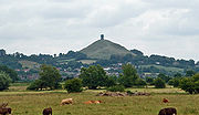
and Glastonbury Tor
Glastonbury Tor
Glastonbury Tor is a hill at Glastonbury, Somerset, England, which features the roofless St. Michael's Tower. The site is managed by the National Trust. It has been designated as a Scheduled Ancient Monument ....
—the lowland landscape was formed only during the last 10,000 years, following the end of the last ice age
Ice age
An ice age or, more precisely, glacial age, is a generic geological period of long-term reduction in the temperature of the Earth's surface and atmosphere, resulting in the presence or expansion of continental ice sheets, polar ice sheets and alpine glaciers...
. Glastonbury Tor is composed of Upper Lias
Early Jurassic
The Early Jurassic epoch is the earliest of three epochs of the Jurassic period...
Sand. The Poldens
Polden Hills
The Polden Hills in Somerset, England are a long, low ridge, extending for , and separated from the Mendip Hills, to which they are nearly parallel, by a marshy tract, known as the Somerset Levels...
and the Isle of Wedmore
Wedmore
Wedmore is a village and civil parish in the county of Somerset, England. It is situated on raised ground, in the Somerset Levels between the River Axe and River Brue, often called the Isle of Wedmore. It forms part of Sedgemoor district...
are composed of Blue Lias
Blue Lias
The Blue Lias is a geologic formation in southern, eastern and western England and parts of South Wales, part of the Lias Group. The Blue Lias consists of a sequence of limestone and shale layers, laid down in latest Triassic and early Jurassic times, between 195 and 200 million years ago...
and Marl
Marl
Marl or marlstone is a calcium carbonate or lime-rich mud or mudstone which contains variable amounts of clays and aragonite. Marl was originally an old term loosely applied to a variety of materials, most of which occur as loose, earthy deposits consisting chiefly of an intimate mixture of clay...
, while the Mendips
Mendip Hills
The Mendip Hills is a range of limestone hills to the south of Bristol and Bath in Somerset, England. Running east to west between Weston-super-Mare and Frome, the hills overlook the Somerset Levels to the south and the Avon Valley to the north...
are largely Carboniferous limestone
Carboniferous limestone
Carboniferous Limestone is a term used to describe a variety of different types of limestone occurring widely across Great Britain and Ireland which were deposited during the Dinantian epoch of the Carboniferous period. They were formed between 363 and 325 million years ago...
. Although sea level changes since the Pliocene
Pliocene
The Pliocene Epoch is the period in the geologic timescale that extends from 5.332 million to 2.588 million years before present. It is the second and youngest epoch of the Neogene Period in the Cenozoic Era. The Pliocene follows the Miocene Epoch and is followed by the Pleistocene Epoch...
led to changes in sea level and the laying down of vegetation, the peak of the peat formation took place in swamp
Swamp
A swamp is a wetland with some flooding of large areas of land by shallow bodies of water. A swamp generally has a large number of hammocks, or dry-land protrusions, covered by aquatic vegetation, or vegetation that tolerates periodical inundation. The two main types of swamp are "true" or swamp...
conditions around 6,000 years ago, although in some areas it continued into medieval times.
It is a mainly agricultural region, typically with open fields of permanent grass surrounded by ditches with willow
Willow
Willows, sallows, and osiers form the genus Salix, around 400 species of deciduous trees and shrubs, found primarily on moist soils in cold and temperate regions of the Northern Hemisphere...
trees. Access to individual areas of the Moors and Levels, especially for cattle, was provided by means of "droves", i.e. green lanes, leading off the public highways. Some of the old roads, in contrast to the old hollow ways
Sunken lane
A sunken lane is a road which has over time fallen significantly lower than the land on either side. They are created incrementally by erosion, by water and traffic...
found in other areas of England, are causeway
Causeway
In modern usage, a causeway is a road or railway elevated, usually across a broad body of water or wetland.- Etymology :When first used, the word appeared in a form such as “causey way” making clear its derivation from the earlier form “causey”. This word seems to have come from the same source by...
s raised above the level of the surrounding land, with a drainage ditch running along each side.
Settlements
Most of the settlements on the Levels are small villages. In the southern area the civil parish of Aller
Aller, Somerset
Aller is a village and parish in Somerset, England, situated west of Somerton on the A372 road towards Bridgwater in the South Somerset district. The village has a population of 374...
, which has a population of 374, includes the hamlet
Hamlet (place)
A hamlet is usually a rural settlement which is too small to be considered a village, though sometimes the word is used for a different sort of community. Historically, when a hamlet became large enough to justify building a church, it was then classified as a village...
of Beer (sometimes Bere) and the deserted medieval village
Deserted medieval village
In the United Kingdom, a deserted medieval village is a former settlement which was abandoned during the Middle Ages, typically leaving no trace apart from earthworks or cropmarks. If there are fewer than three inhabited houses the convention is to regard the site as deserted; if there are more...
of Oath on the opposite bank of the River Parrett. The area known as the Isle of Athelney
Athelney
Athelney is located between the villages of Burrowbridge and East Lyng in the Sedgemoor district of Somerset, England. The area is known as the Isle of Athelney, because it was once a very low isolated island in the 'very great swampy and impassable marshes' of the Somerset Levels. Much of the...
was once a very low isolated island linked by a causeway to East Lyng
Lyng, Somerset
Lyng is a civil parish in Somerset, England, comprising the villages of West Lyng and East Lyng and the hamlet of Bankland.-History:The name derives from the Old English hlenc, meaning hill....
, each end of which was protected by a semi-circular stockade
Stockade
A stockade is an enclosure of palisades and tall walls made of logs placed side by side vertically with the tops sharpened to provide security.-Stockade as a security fence:...
and ditch. The ditch on the island is now known to date from the Iron Age
Iron Age
The Iron Age is the archaeological period generally occurring after the Bronze Age, marked by the prevalent use of iron. The early period of the age is characterized by the widespread use of iron or steel. The adoption of such material coincided with other changes in society, including differing...
, and was used by Alfred the Great
Alfred the Great
Alfred the Great was King of Wessex from 871 to 899.Alfred is noted for his defence of the Anglo-Saxon kingdoms of southern England against the Vikings, becoming the only English monarch still to be accorded the epithet "the Great". Alfred was the first King of the West Saxons to style himself...
as a fort before the Battle of Ethandun in May 878; in gratitude for his victory Alfred founded a monastery
Monastery
Monastery denotes the building, or complex of buildings, that houses a room reserved for prayer as well as the domestic quarters and workplace of monastics, whether monks or nuns, and whether living in community or alone .Monasteries may vary greatly in size – a small dwelling accommodating only...
, Athelney Abbey
Athelney Abbey
Athelney Abbey, established in the county of Somerset, England, was founded by King Alfred in 888, as a religious house for monks of the Order of St. Benedict. It was dedicated to our Blessed Saviour, St. Peter, St. Paul, and St...
, on the Isle in 888, which survived until the Dissolution of the Monasteries
Dissolution of the Monasteries
The Dissolution of the Monasteries, sometimes referred to as the Suppression of the Monasteries, was the set of administrative and legal processes between 1536 and 1541 by which Henry VIII disbanded monasteries, priories, convents and friaries in England, Wales and Ireland; appropriated their...
under Henry VIII
Henry VIII of England
Henry VIII was King of England from 21 April 1509 until his death. He was Lord, and later King, of Ireland, as well as continuing the nominal claim by the English monarchs to the Kingdom of France...
in 1539. Bawdrip
Bawdrip
Bawdrip is a village and civil parish in the Sedgemoor district of Somerset, England. The village is on the south side of the Polden Hills about north-east of Bridgwater. According to the 2001 census the parish had a population of 498. The parish includes the hamlets of Bradney and Horsey...
is a small village which has a population of 498. Brent Knoll
Brent Knoll
Brent Knoll is a village in Somerset, England, which lies on the southern edge of Brent Knoll – a hill with a height of 137 metres that dominates the low surrounding landscape of the Somerset Levels.-History:...
is a large village at the foot of a 137 metres (449.5 ft) hill
Brent Knoll Camp
Brent Knoll Camp is an Iron Age Hill fort at Brent Knoll, from Burnham-on-Sea, Somerset, England. It has been designated as a Scheduled Ancient Monument , and is now in the care of the National Trust....
that dominates the surrounding landscape; the name means Beacon Hill in Old English. Brent Knoll has been inhabited since at least the Bronze Age
Bronze Age
The Bronze Age is a period characterized by the use of copper and its alloy bronze as the chief hard materials in the manufacture of some implements and weapons. Chronologically, it stands between the Stone Age and Iron Age...
. Before the Somerset Levels were drained, Brent Knoll was an island known as the Isle (or Mount) of Frogs.
Glastonbury
Glastonbury
Glastonbury is a small town in Somerset, England, situated at a dry point on the low lying Somerset Levels, south of Bristol. The town, which is in the Mendip district, had a population of 8,784 in the 2001 census...
(population 8,784) and Street
Street, Somerset
Street is a small village and civil parish in the county of Somerset, England. It is situated on a dry spot in the Somerset Levels, at the end of the Polden Hills, south-west of Glastonbury. The 2001 census records the village as having a population of 11,066...
(11,066) lie on opposite sides of the River Brue
River Brue
The River Brue originates in the parish of Brewham in Somerset, England, and reaches the sea some 50 km west at Burnham-on-Sea. It originally took a different route from Glastonbury to the sea, but this was changed by the monastery in the twelfth century....
, and provide a central point for trade and commerce. Larger centres are generally on slightly higher ground around the edges of the Levels. Bridgwater
Bridgwater
Bridgwater is a market town and civil parish in Somerset, England. It is the administrative centre of the Sedgemoor district, and a major industrial centre. Bridgwater is located on the major communication routes through South West England...
is a market town
Market town
Market town or market right is a legal term, originating in the medieval period, for a European settlement that has the right to host markets, distinguishing it from a village and city...
, the administrative centre of the Sedgemoor
Sedgemoor
Sedgemoor is a low lying area of land in Somerset, England. It lies close to sea level south of the Polden Hills, historically largely marsh . The eastern part is known as King's Sedgemoor, and the western part West Sedgemoor. Sedgemoor is part of the area now known as the Somerset Levels...
district, and a major industrial centre. With a population of 33,698, it straddles the major communication routes through South West England
South West England
South West England is one of the regions of England defined by the Government of the United Kingdom for statistical and other purposes. It is the largest such region in area, covering and comprising Bristol, Gloucestershire, Somerset, Dorset, Wiltshire, Devon, Cornwall and the Isles of Scilly. ...
. Situated on the edge of the Somerset Levels, along both banks of the River Parrett and 10 miles (16 km) from its mouth, it was at one time a major port and trading centre. The hamlet of Dunball
Dunball
Dunball is a small hamlet west of the village of Puriton and close to the town of Bridgwater, Somerset, England.Just north of Dunball is Down End which is the site of Down End Castle a motte-and-bailey castle, which has been designated as a Scheduled Ancient Monument.Located on the A38, adjacent to...
forms part of the port on the river. Burrowbridge
Burrowbridge
Burrowbridge is a village and civil parish in Somerset, England, situated on the River Parrett and A361 road south east of Bridgwater in the Taunton Deane district on the edge of the Somerset Levels...
lies on the River Parrett further inland. The name probably comes from the Old English buruh (fortified hill) and brycg (bridge). In the village is Burrow Mump
Burrow Mump
Burrow Mump is a hill and historic site overlooking Southlake Moor in the village of Burrowbridge in Taunton Deane, Somerset, England. It is a Scheduled Ancient Monument. Burrow Mump is also known as St Michael's Borough or Tutteyate...
, an ancient earthwork now owned by the National Trust
National Trust for Places of Historic Interest or Natural Beauty
The National Trust for Places of Historic Interest or Natural Beauty, usually known as the National Trust, is a conservation organisation in England, Wales and Northern Ireland...
. Burrow Mump is also known as St Michael's Borough or Tutteyate. It is a natural hill of Triassic
Triassic
The Triassic is a geologic period and system that extends from about 250 to 200 Mya . As the first period of the Mesozoic Era, the Triassic follows the Permian and is followed by the Jurassic. Both the start and end of the Triassic are marked by major extinction events...
sandstone
Sandstone
Sandstone is a sedimentary rock composed mainly of sand-sized minerals or rock grains.Most sandstone is composed of quartz and/or feldspar because these are the most common minerals in the Earth's crust. Like sand, sandstone may be any colour, but the most common colours are tan, brown, yellow,...
capped by Keuper marl
Keuper marl
Keuper marl is the former name for a layer of mudstones and siltstones from the late Triassic period . Typically red, or occasionally...
. Excavations showed evidence of a medieval masonry building on the top of the hill.
Along the coast, settlements such as Berrow
Berrow, Somerset
Berrow is a village and civil parish in the Sedgemoor district of Somerset, England. According to the 2001 census it had a population of 1,766.-History:Berrow was part of the hundred of Brent-cum-Wrington.-Governance:...
are built on the line of sand dunes separating the low-lying marshes from the Bristol Channel. At the northern end Bleadon
Bleadon
Bleadon is a village and civil parish in the historic countyof Somerset, England. It is about south of Weston-super-Mare and, according to the 2001 census, has a population of 1,068.-History:...
lies on the River Axe; and there was for many years a small harbour, sometimes known as Lympsham Wharf. The arrival of the Bristol and Exeter Railway
Bristol and Exeter Railway
The Bristol & Exeter Railway was a railway company formed to connect Bristol and Exeter.The company's head office was situated outside their Bristol station...
in 1841, which crossed the Axe on a bridge, obstructed river traffic beyond the wharf, making it the limit of navigation for coastal vessels. An Act
Act of Parliament
An Act of Parliament is a statute enacted as primary legislation by a national or sub-national parliament. In the Republic of Ireland the term Act of the Oireachtas is used, and in the United States the term Act of Congress is used.In Commonwealth countries, the term is used both in a narrow...
of 1915 authorised the drainage of the river and installation of a flood gate at Bleadon, although attempts to control the water had occurred on Bleadon Level since medieval times, including an early windmill
Windmill
A windmill is a machine which converts the energy of wind into rotational energy by means of vanes called sails or blades. Originally windmills were developed for milling grain for food production. In the course of history the windmill was adapted to many other industrial uses. An important...
, in 1613, to pump water into the sea from behind a sea wall. Burnham-on-Sea
Burnham-on-Sea
Burnham-on-Sea is a town in Somerset, England, at the mouth of the River Parrett and Bridgwater Bay. Burnham was a small village until the late 18th century, when it began to grow because of its popularity as a seaside resort. It forms part of the parish of Burnham-on-Sea and Highbridge...
(population 18,401) is at the mouth of the River Parrett where it enters Bridgwater Bay
Bridgwater Bay
Bridgwater Bay is on the Bristol Channel, north of Bridgwater in Somerset, England at the mouth of the River Parrett and the end of the River Parrett Trail. It consists of large areas of mud flats, saltmarsh, sandflats and shingle ridges, some of which are vegetated...
. The position of the town on the edge of the Somerset Levels has resulted in a history dominated by land reclamation and sea defences since Roman
Roman Britain
Roman Britain was the part of the island of Great Britain controlled by the Roman Empire from AD 43 until ca. AD 410.The Romans referred to the imperial province as Britannia, which eventually comprised all of the island of Great Britain south of the fluid frontier with Caledonia...
times. Burnham was seriously affected by the Bristol Channel floods of 1607
Bristol Channel floods, 1607
The Bristol Channel floods, which occurred on 30 January 1607 , resulted in the drowning of a large number of people and the destruction of a large amount of farmland and livestock...
, and various flood defences have been installed since then. A concrete sea wall was built in 1911, and after the Second World War further additions to the defences were made, using the remains of a Mulberry harbour
Mulberry harbour
A Mulberry harbour was a British type of temporary harbour developed in World War II to offload cargo on the beaches during the Allied invasion of Normandy....
; the present curved concrete wall was completed in 1988. Highbridge
Highbridge, Somerset
Highbridge is a small market town situated on the edge of the Somerset Levels near the mouth of the River Brue. It is in the County of Somerset, and is approximately north west of Taunton, the county town of Somerset. Highbridge is in the District of Sedgemoor, being situated approximately north...
, which neighbours Burnham, is near the mouth of the River Brue and the villages of East and West Huntspill
Huntspill
West Huntspill and East Huntspill are villages and civil parishes on the Huntspill Level, near Highbridge, Somerset, West of England. The civil parish of West Huntspill contains the hamlet of Alstone, and East Huntspill includes Cote....
.
Climate
Along with the rest of South West EnglandSouth West England
South West England is one of the regions of England defined by the Government of the United Kingdom for statistical and other purposes. It is the largest such region in area, covering and comprising Bristol, Gloucestershire, Somerset, Dorset, Wiltshire, Devon, Cornwall and the Isles of Scilly. ...
the Somerset Levels have a temperate climate, which is generally wetter and milder than the rest of the country. The annual mean temperature is approximately 10 °C (50 °F). Seasonal temperature variation is less extreme than most of the United Kingdom because of the adjacent sea. The summer months of July and August are the warmest, with mean daily maxima of approximately 21 °C (69.8 °F). In winter, mean minimum temperatures of 1 or are common. The Azores high pressure area
Azores High
The Azores High is a large subtropical semi-permanent centre of high atmospheric pressure found near the Azores in the Atlantic Ocean, at the Horse latitudes...
influences the south-west of England's summer weather, but convective
Convection
Convection is the movement of molecules within fluids and rheids. It cannot take place in solids, since neither bulk current flows nor significant diffusion can take place in solids....
cloud sometimes forms inland, reducing the number of hours of sunshine. Annual sunshine rates are slightly less than the regional average of 1,600 hours. In December 1998, there were 20 days without sun recorded at Yeovilton
Yeovilton
Yeovilton is a village and civil parish in Somerset, England, situated east of Ilchester, north of Yeovil, in the South Somerset district. The village has a population of approximately 670....
. Most rainfall in the south-west is caused by convection
Convection
Convection is the movement of molecules within fluids and rheids. It cannot take place in solids, since neither bulk current flows nor significant diffusion can take place in solids....
or Atlantic depressions, which are most active in autumn and winter, when they are the chief cause of rain. In summer, a large proportion of the rainfall is caused by the Sun heating the land, leading to convection and to showers and thunderstorms. Average rainfall is around 700 mm (27.6 in), and about 8–15 days of snowfall is typical. November to March have the highest mean wind speeds, and June to August have the lightest winds. The predominant wind direction is from the southwest.
Drainage
There was a port at Bleadney on the River Axe in the 8th century which allowed goods to be brought to within 3 miles (5 km) of Wells
Wells
Wells is a cathedral city and civil parish in the Mendip district of Somerset, England, on the southern edge of the Mendip Hills. Although the population recorded in the 2001 census is 10,406, it has had city status since 1205...
. In 1200, a wharf was constructed at Rackley near Axbridge
Axbridge
Axbridge is a town in Somerset, England, situated in the Sedgemoor district on the River Axe, near the southern edge of the Mendip Hills. The town population according to the 2001 census was 2,024.-History:...
. The Parrett was navigable up as far as Langport
Langport
Langport is a small town and civil parish in Somerset, England, situated west of Somerton in the South Somerset district. The town has a population of 1,067. The parish includes the hamlets of Bowdens and Combe...
in 1600, with 15 to 20 ton barges. The Domesday Book
Domesday Book
Domesday Book , now held at The National Archives, Kew, Richmond upon Thames in South West London, is the record of the great survey of much of England and parts of Wales completed in 1086...
recorded that drainage of the higher grounds was under way, although the moors at Wedmoor were said to be useless. In the Middle Ages, the monasteries of Glastonbury
Glastonbury Abbey
Glastonbury Abbey was a monastery in Glastonbury, Somerset, England. The ruins are now a grade I listed building, and a Scheduled Ancient Monument and are open as a visitor attraction....
, Athelney
Athelney
Athelney is located between the villages of Burrowbridge and East Lyng in the Sedgemoor district of Somerset, England. The area is known as the Isle of Athelney, because it was once a very low isolated island in the 'very great swampy and impassable marshes' of the Somerset Levels. Much of the...
, and Muchelney
Muchelney Abbey
Muchelney Abbey is an English Heritage property in the village of Muchelney in the Somerset Levels, England.It comprises the remains and foundations of a medieval Benedictine abbey, the site of an earlier Anglo-Saxon abbey, and an early Tudor house dating from the 16th century, formerly the...
were responsible for much of the drainage. In 1129, the Abbot of Glastonbury was recorded as inspecting enclosed land at Lympsham
Lympsham
Lympsham is a village and civil parish six miles west of Axbridge and six miles south-east of Weston-super-Mare, close to the River Axe in Somerset, England. The parish includes the hamlet of Wick where Wick Farmhouse dates from the mid 18th century....
. Efforts to control flooding on the Parrett
River Parrett
The River Parrett flows through the counties of Dorset and Somerset in South West England, from its source in the Thorney Mills springs in the hills around Chedington in Dorset...
were recorded around the same date. In 1234, 722 acres (2.9 km²) were reclaimed near Westonzoyland
Westonzoyland
Westonzoyland is a village and civil parish in Somerset, England. It is situated on the Somerset Levels, south east of Bridgwater.-History:The name of the parish derives from its location on the "island" of Sowy, an area of slightly higher ground on the Somerset Levels between the River Cary and...
and, from the accounts in the abbey's rent books, this had increased to 972 acres (393.4 ha) by 1240. Flooding of adjacent moor land was partially addressed during the 13th century by the construction of a number of embankment walls to contain the Parrett. They included Southlake Wall, Burrow Wall, and Lake Wall. The River Tone was also diverted by the Abbot of Athelney and other land owners into a new embanked channel, joining the Parrett upstream from its original confluence.
River Brue
The River Brue originates in the parish of Brewham in Somerset, England, and reaches the sea some 50 km west at Burnham-on-Sea. It originally took a different route from Glastonbury to the sea, but this was changed by the monastery in the twelfth century....
, Huntspill
River Huntspill
The River Huntspill is an artificial river, in the Somerset Levels, in the Sedgemoor district of Somerset, England. It was built in 1940 to supply process water to the armaments factory at Puriton, and has resulted in reduced flooding of the lower Brue Valley.-History:The concept for the Huntspill...
, Parrett
River Parrett
The River Parrett flows through the counties of Dorset and Somerset in South West England, from its source in the Thorney Mills springs in the hills around Chedington in Dorset...
, Tone
River Tone
The River Tone is a river in Somerset, England, which is about long. It rises at Beverton Pond near Huish Champflower in the Brendon Hills, and is dammed at Clatworthy Reservoir. The reservoir outfall continues through Taunton and Curry and Hay Moors, which are designated as a Site of Special...
, and Yeo
River Yeo (South Somerset)
The River Yeo, also known as the River Ivel or River Gascoigne, is a tributary of the River Parrett in north Dorset and south Somerset, England....
, together with the King's Sedgemoor Drain
King's Sedgemoor Drain
King's Sedgemoor Drain is an artificial drainage channel which diverts the River Cary in Somerset, England along the southern flank of the Polden Hills, to discharge into the River Parrett at Dunball near Bridgwater. As the name suggests, the channel is used to help drain the peat moors of King's...
, an artificial channel into which the River Cary
River Cary
The River Cary is a river in Somerset, England.The River Cary has its source at Park Pond in Castle Cary, and then flows southwest through Cary Moor to Babcary, where there is a biological Site of Special Scientific Interest at Babcary Meadows and Cary Fitzpaine. It then flows northwest through...
now runs. Previously, the Cary ran into the Tone while the Brue ran through Meare Pool
Meare Pool
Meare Pool was a lake in the Somerset Levels in South West England....
(now drained) and the Panborough Gap, and then into the Axe. Another accomplishment in the Middle Ages was the construction of the tidal Pillrow Cut, joining the Brue and Axe. In 1500, there was said to be 70000 acres (283 km²) of floodable land of which only 20000 acres (81 km²) had been reclaimed. In 1597, 50 acres (20.2 ha) of land were recovered near the Parrett estuary; a few years later, 140 acres (56.7 ha) near Pawlett were recovered by means of embankments; and three further reclamations, totalling 110 acres (44.5 ha), had been undertaken downstream of Bridgwater by 1660.
In the early 17th century, during the time of King James I, abortive plans were made to drain and enclose much of Sedgemoor
Sedgemoor
Sedgemoor is a low lying area of land in Somerset, England. It lies close to sea level south of the Polden Hills, historically largely marsh . The eastern part is known as King's Sedgemoor, and the western part West Sedgemoor. Sedgemoor is part of the area now known as the Somerset Levels...
, which the local Lords supported but opposed by the Commoners who would have lost grazing rights. In 1632, Charles I
Charles I of England
Charles I was King of England, King of Scotland, and King of Ireland from 27 March 1625 until his execution in 1649. Charles engaged in a struggle for power with the Parliament of England, attempting to obtain royal revenue whilst Parliament sought to curb his Royal prerogative which Charles...
sold the Crown's interest in the scheme, and it was taken over by a consortium that included Sir Cornelius Vermuyden
Cornelius Vermuyden
Sir Cornelius Wasterdyk Vermuyden was a Dutch engineer who introduced Dutch reclamation methods to Britain, and made the first important attempts to drain The Fens of East Anglia.-Life:...
, a Dutch
Dutch people
The Dutch people are an ethnic group native to the Netherlands. They share a common culture and speak the Dutch language. Dutch people and their descendants are found in migrant communities worldwide, notably in Suriname, Chile, Brazil, Canada, Australia, South Africa, New Zealand, and the United...
drainage engineer. However, the work was delayed by the English Civil War
English Civil War
The English Civil War was a series of armed conflicts and political machinations between Parliamentarians and Royalists...
and later defeated in parliament after local opposition. In 1638, it was reported that nearly 2600 acres (11 km²) of Tealham and Tadham Moors
Tealham and Tadham Moors
Tealham and Tadham Moors is a 917.6 hectare biological Site of Special Scientific Interest south of Wedmore in Somerset, notified in 1985.Land south of this site is included in Catcott, Edington and Chilton Moors SSSI....
were not reclaimed, with a total of 30500 acres (123.43 km²) being undrained. Between 1785 and 1791, much of the lowest part of the peat moors was enclosed. In 1795, John Billingsley
John Billingsley (agriculturist)
John Billingsley was an agricultural pioneer in 18th century Somerset, England.The writer of the 1794 Survey of Somerset, Billingsley was a leading agriculturalist who was one of the founders of the Bath and West Society, known today as the Royal Bath and West of England Society...
advocated enclosure and the digging of rhyne
Rhyne
A rhyne , rhine/rhyne , or reen is a drainage ditch, or canal, used to turn areas of wetland at around sea level into useful pasture....
s (a local name for drainage channels, pronounced "reens" in the east and rhyne to the west) between plots, and wrote in his Agriculture of the County of Somerset that 4400 acres (18 km²) had been enclosed in the last 20 years in Wedmore
Wedmore
Wedmore is a village and civil parish in the county of Somerset, England. It is situated on raised ground, in the Somerset Levels between the River Axe and River Brue, often called the Isle of Wedmore. It forms part of Sedgemoor district...
and Meare
Meare
Meare is a village and civil parish north west of Glastonbury on the Somerset Levels, in the Mendip district of Somerset, England. The parish includes the village of Westhay.-History:...
, 350 acres (1.4 km²) at Nyland, 900 acres (3.64 km²) at Blackford, 2000 acres (8 km²) at Mark
Mark, Somerset
Mark is a village and civil parish which lies approximately from Bridgwater, from Axbridge, and from Highbridge in the Sedgemoor district of the county of Somerset, England...
, 100 acre (0.404686 km²) in Shapwick
Shapwick, Somerset
Shapwick is a village on the Somerset Levels, in the Sedgemoor district of Somerset, England. It is situated to the west of Glastonbury.-History:Shapwick is the site of one end of the Sweet Track, an ancient causeway dating from the 39th century BC....
, and 1700 acres (7 km²) at Westhay
Westhay
Westhay is a village in Somerset, England. It is situated in the parish of Meare, north west of Glastonbury on the Somerset Levels, in the Mendip district.The name means 'The west field that is enclosed by hedges' from the Old English west and haga...
. At Westhay Moor
Westhay Moor
Westhay Moor is a 513.7 hectare biological Site of Special Scientific Interest 2.5km north-east of Westhay village and 4km from Wedmore in Somerset, notified in 1971...
in the early 19th century, it was shown how peat bogs could be successfully drained and top-dressed with silt deposited via flooding, creating a very rich soil. The character of the soil was also changed by the spreading of clay and silt from the digging of King's Sedgemoor Drain.
Little attempt was made during the 17th and 18th centuries to pump water, possibly because the coal-driven Newcomen steam engine
Newcomen steam engine
The atmospheric engine invented by Thomas Newcomen in 1712, today referred to as a Newcomen steam engine , was the first practical device to harness the power of steam to produce mechanical work. Newcomen engines were used throughout Britain and Europe, principally to pump water out of mines,...
s would have been uneconomical. It is unclear why windmill
Windmill
A windmill is a machine which converts the energy of wind into rotational energy by means of vanes called sails or blades. Originally windmills were developed for milling grain for food production. In the course of history the windmill was adapted to many other industrial uses. An important...
s were not employed, as they were onThe Fens
The Fens
The Fens, also known as the , are a naturally marshy region in eastern England. Most of the fens were drained several centuries ago, resulting in a flat, damp, low-lying agricultural region....
of East Anglia
East Anglia
East Anglia is a traditional name for a region of eastern England, named after an ancient Anglo-Saxon kingdom, the Kingdom of the East Angles. The Angles took their name from their homeland Angeln, in northern Germany. East Anglia initially consisted of Norfolk and Suffolk, but upon the marriage of...
, but only two examples have been recorded on the Levels: one at Bleadon
Bleadon
Bleadon is a village and civil parish in the historic countyof Somerset, England. It is about south of Weston-super-Mare and, according to the 2001 census, has a population of 1,068.-History:...
at the mouth of the River Axe, where a sea wall had been built, and the other at Common Moor north of Glastonbury, which was being drained following a private Act of Parliament in 1721. The first steam pumping station was Westonzoyland Pumping Station
Westonzoyland Pumping Station Museum
The Westonzoyland Pumping Station Museum is a small Industrial Heritage museum dedicated to steam powered machinery in Westonzoyland, Somerset, England....
in 1830, followed by more effective ones from 1860. Automatic electric pumps are used today.
River Huntspill
The River Huntspill is an artificial river, in the Somerset Levels, in the Sedgemoor district of Somerset, England. It was built in 1940 to supply process water to the armaments factory at Puriton, and has resulted in reduced flooding of the lower Brue Valley.-History:The concept for the Huntspill...
was constructed during the Second World War with sluices at both ends to provide a guaranteed daily supply of 4500000 gallons (20,457,405 l) of "process water". It was intended that in the summer, when water supply was lower, it would serve as a reservoir with water pumped from the moors; and in winter serve as a drainage channel, via gravity drainage. Geotechnical
Geotechnical engineering
Geotechnical engineering is the branch of civil engineering concerned with the engineering behavior of earth materials. Geotechnical engineering is important in civil engineering, but is also used by military, mining, petroleum, or any other engineering concerned with construction on or in the ground...
problems prevented it from being dug as deep as originally intended and so gravity-drainage of the moors was not possible: thus, water is pumped up into the river throughout the year. The Sowy River
Sowy River
The Sowy River is an artificial drainage channel in Somerset, England.It is a embanked channel which starts at Monks Leaze clyce below Langport, and carries excess water from the River Parrett to the King's Sedgemoor Drain, from where it flows to the estuary by gravity, rejoining the Parrett near...
between the River Parrett and King's Sedgemoor Drain was completed in 1972. The Levels and Moors are now artificially drained by a network of rhynes which are pumped up into "drains". Water levels are managed by the Levels internal drainage board
Internal Drainage Board
An internal drainage board is a type of operating authority which is established in areas of special drainage need in England and Wales with permissive powers to undertake work to secure clean water drainage and water level management within drainage districts...
s (IDBs); the Levels are not as intensively drained or farmed as the East Anglia
East Anglia
East Anglia is a traditional name for a region of eastern England, named after an ancient Anglo-Saxon kingdom, the Kingdom of the East Angles. The Angles took their name from their homeland Angeln, in northern Germany. East Anglia initially consisted of Norfolk and Suffolk, but upon the marriage of...
n fen
Fen
A fen is a type of wetland fed by mineral-rich surface water or groundwater. Fens are characterised by their water chemistry, which is neutral or alkaline, with relatively high dissolved mineral levels but few other plant nutrients...
s, historically a similar area of low marsh. They are still liable to widespread fresh water flooding in winter. One of the approaches to reducing the risk of flooding within the catchment area of the Parrett is the planting of new woodlands.
Controversy about the management of the drainage and flood protection has previously involved the activities of IDB's. However, IDB's have been actively participating with the Parrett Catchment Partnership, a partnership of 30 organisations that aims to create a consensus on how water is to be managed, in particular, looking at new ways to achieve sustainable benefits for all local stakeholders.
During 2009 and 2010, work was undertaken to upgrade sluice gates, watercourses, and culverts to enable seasonal flooding of Southlake Moor
Southlake Moor
Southlake Moor is a 196.1 hectare biological Site of Special Scientific Interest near Burrow Mump and Burrowbridge in Somerset, notified in 1985....
during the winter diverting water from the Sowy River
Sowy River
The Sowy River is an artificial drainage channel in Somerset, England.It is a embanked channel which starts at Monks Leaze clyce below Langport, and carries excess water from the River Parrett to the King's Sedgemoor Drain, from where it flows to the estuary by gravity, rejoining the Parrett near...
onto the moor. It has the capacity to hold 1.2 million cubic metres as part of a scheme by the Parrett Internal Drainage Board to restore ten floodplains in Somerset. In spring, the water is drained away to enable the land to be used as pasture during the summer. The scheme is also used to encourage water birds.
Sea defences
Coastal management
In some jurisdictions the terms sea defense and coastal protection are used to mean, respectively, defense against flooding and erosion...
were enhanced in the early 20th century. In addition, the problems of high fresh water floods are aggravated by the unrestricted entry of the tide along the Parrett
River Parrett
The River Parrett flows through the counties of Dorset and Somerset in South West England, from its source in the Thorney Mills springs in the hills around Chedington in Dorset...
, which is the only river in the Levels and Moors that does not have a clyse on it. Discussions on whether a clyse is needed for the Parrett and whether it should be sited at Bridgwater or nearer the mouth of the river date back to 1939, at start of Second World War, and have not been resolved. The Environment Agency
Environment Agency
The Environment Agency is a British non-departmental public body of the Department for Environment, Food and Rural Affairs and an Assembly Government Sponsored Body of the Welsh Assembly Government that serves England and Wales.-Purpose:...
's current "Parrett Catchment Flood Management Plan", published December 2009, divides the Parrett catchment area into eight sub-areas, with the Somerset Levels and Moors falling into sub-area 6 and Bridgwater falling into sub-area 7. As part of the published flood risk assessments for both these sub-areas, it is recognised that: at a future date a tidal clyse may be needed on the Parrett; this causes a funding dilemma; and, geomorphology
Geomorphology
Geomorphology is the scientific study of landforms and the processes that shape them...
studies of the Parrett and the Tone
River Tone
The River Tone is a river in Somerset, England, which is about long. It rises at Beverton Pond near Huish Champflower in the Brendon Hills, and is dammed at Clatworthy Reservoir. The reservoir outfall continues through Taunton and Curry and Hay Moors, which are designated as a Site of Special...
are needed to help address many of the uncertainties associated with a tidal exclusion project.
During the great storm of 1703, waves came four feet (1.2 m) over the sea walls. The sea wall was again breached in 1799, filling the Axe valley with sea water. In 1872, another flood covered 7000 acres (28 km²) and in 1919, 70000 acres (283 km²) were inundated with sea water, poisoning the land for up to 7 years. Since 1990, the drainage board has been charged with looking at the rhyne
Rhyne
A rhyne , rhine/rhyne , or reen is a drainage ditch, or canal, used to turn areas of wetland at around sea level into useful pasture....
s, cleaning them out and keeping them clear, under the overall responsibility of the Environment Agency. With rising sea levels, the work required to maintain the sea defences is likely to become more expensive, and it has been proposed that two inland seas be created. Other studies have recommended maintaining the current defences for five years while undertaking further studies of available options.
Human habitation
A Palaeolithic flint tool found in Westbury is the earliest indication of human presence in the area, dating from approximately 500,000 years ago. Later during the 7th millennium BC the sea level rose and flooded the valleys, forcing the MesolithicMesolithic
The Mesolithic is an archaeological concept used to refer to certain groups of archaeological cultures defined as falling between the Paleolithic and the Neolithic....
people to occupy seasonal camps on the higher ground, indicated by scatters of flints. Subsequent winter flooding probably led to humans in prehistory
Prehistory
Prehistory is the span of time before recorded history. Prehistory can refer to the period of human existence before the availability of those written records with which recorded history begins. More broadly, it refers to all the time preceding human existence and the invention of writing...
only using the Levels in the summer, hence the county of Somerset may derive its name from Sumorsaete, meaning land of the summer people. An alternative suggestion is that the name derives from Seo-mere-saetan meaning "settlers by the sea lakes". The Neolithic
Neolithic
The Neolithic Age, Era, or Period, or New Stone Age, was a period in the development of human technology, beginning about 9500 BC in some parts of the Middle East, and later in other parts of the world. It is traditionally considered as the last part of the Stone Age...
people continued to exploit the reedswamps for their natural resources and started to construct wooden trackway
Trackway
A trackway is an ancient route of travel for people or animals. In biology, a trackway can be a set of impressions in the soft earth, usually a set of footprints, left by an animal. A fossil trackway is the fossilized imprint of a trackway. Trackways have been found all over the world...
s such as the Sweet
Sweet Track
The Sweet Track is an ancient causeway in the Somerset Levels, England. It was built in 3807 or 3806 BC and has been claimed to be the oldest road in the world. It was the oldest timber trackway discovered in Northern Europe until the 2009 discovery of a 6,000 year-old trackway in Belmarsh Prison...
and Post Track
Post Track
The Post Track is an ancient causeway in the Somerset Levels, England. It dates from around 3838 BC, making it some 30 years older than the Sweet Track from the same area. It was constructed of long ash planks, with lime and hazel posts spaced along 3-metre intervals...
s. The Sweet Track, named after the peat digger who discovered it in 1970 and dating from the 3800s BC
39th century BC
-Events:* The Post Track, an ancient causeway in the Somerset Levels, England, is built, ca. 3838 BC. It is one of the oldest engineered roads discovered in Northern Europe....
, is the world's oldest timber trackway
Timber trackway
A timber trackway was typically used as the shortest route between two places in a bog or peatland and have been built for thousands of years as a means of getting between two points. Timber trackways have been identified in archaeological finds in Neolithic England, dating to 500 years before...
, once thought to be the world's oldest engineered roadway. The track was built between what was in the early 4th millennium BC an island at Westhay
Westhay
Westhay is a village in Somerset, England. It is situated in the parish of Meare, north west of Glastonbury on the Somerset Levels, in the Mendip district.The name means 'The west field that is enclosed by hedges' from the Old English west and haga...
and a ridge of high ground at Shapwick
Shapwick, Somerset
Shapwick is a village on the Somerset Levels, in the Sedgemoor district of Somerset, England. It is situated to the west of Glastonbury.-History:Shapwick is the site of one end of the Sweet Track, an ancient causeway dating from the 39th century BC....
, close to the River Brue
River Brue
The River Brue originates in the parish of Brewham in Somerset, England, and reaches the sea some 50 km west at Burnham-on-Sea. It originally took a different route from Glastonbury to the sea, but this was changed by the monastery in the twelfth century....
. The remains of similar tracks have been uncovered nearby, connecting settlements on the peat bog including the Honeygore, Abbotts Way, Bells, Bakers, Westhay, and Nidons trackways.
The Levels contain the best-preserved prehistoric village in the UK, Glastonbury Lake Village
Glastonbury Lake Village
Glastonbury Lake Village was an iron age village on the Somerset Levels near Godney, some north west of Glastonbury, Somerset, England. It has been designated as a Scheduled Ancient Monument and covers an area of north to south by east to west....
, as well as two others at Meare Lake Village
Meare Lake Village
Meare Lake Village is the site of an Iron Age settlement on the Somerset Levels at Meare, Somerset, England. It is a Scheduled Ancient Monument.-Description:...
. Discovered in 1892 by Arthur Bulleid, it was inhabited by about 200 people living in 14 roundhouses
Roundhouse (dwelling)
The roundhouse is a type of house with a circular plan, originally built in western Europe before the Roman occupation using walls made either of stone or of wooden posts joined by wattle-and-daub panels and a conical thatched roof. Roundhouses ranged in size from less than 5m in diameter to over 15m...
, and was built on a morass
Marsh
In geography, a marsh, or morass, is a type of wetland that is subject to frequent or continuous flood. Typically the water is shallow and features grasses, rushes, reeds, typhas, sedges, other herbaceous plants, and moss....
on an artificial foundation of timber filled with brushwood, bracken
Bracken
Bracken are several species of large, coarse ferns of the genus Pteridium. Ferns are vascular plants that have alternating generations, large plants that produce spores and small plants that produce sex cells . Brackens are in the family Dennstaedtiaceae, which are noted for their large, highly...
, rubble and clay. Investigation of the Meare Pool indicates that it was formed by the encroachment of raised peat bogs, particularly during the Subatlantic climatic period (1st millennium BC
1st millennium BC
The 1st millennium BC encompasses the Iron Age and sees the rise of many successive empires, and spanned from 1000 BC to 1 BC.The Neo-Assyrian Empire, followed by the Achaemenids. In Greece, Classical Antiquity begins with the colonization of Magna Graecia and peaks with the rise of Hellenism. The...
), and core sampling
Core sample
A core sample is a cylindrical section of a naturally occurring substance. Most core samples are obtained by drilling with special drills into the substance, for example sediment or rock, with a hollow steel tube called a core drill. The hole made for the core sample is called the "core hole". A...
demonstrates that it is filled with at least 2 metres (6.6 ft) of detritus mud.
The two villages within Meare Pool appear to originate from a collection of structures erected on the surface of the dried peat, such as tents, windbreaks and animal folds. Clay was later spread over the peat, providing raised stands for occupation, industry and movement, and in some areas thicker clay spreads accommodated hearths built of clay or stone.
The area continued to be inhabited during the Bronze Age
Bronze Age
The Bronze Age is a period characterized by the use of copper and its alloy bronze as the chief hard materials in the manufacture of some implements and weapons. Chronologically, it stands between the Stone Age and Iron Age...
, when the population supported itself largely by hunting and fishing in the surrounding marshes, living on artificial islands connected by wooden causeway
Causeway
In modern usage, a causeway is a road or railway elevated, usually across a broad body of water or wetland.- Etymology :When first used, the word appeared in a form such as “causey way” making clear its derivation from the earlier form “causey”. This word seems to have come from the same source by...
s on wooden piles. There have been many finds of metalwork during peat cutting, which may have been devotional offerings. Brent Knoll
Brent Knoll
Brent Knoll is a village in Somerset, England, which lies on the southern edge of Brent Knoll – a hill with a height of 137 metres that dominates the low surrounding landscape of the Somerset Levels.-History:...
has been settled by humans since at least the Bronze Age. It is the site of an Iron Age
Iron Age
The Iron Age is the archaeological period generally occurring after the Bronze Age, marked by the prevalent use of iron. The early period of the age is characterized by the widespread use of iron or steel. The adoption of such material coincided with other changes in society, including differing...
hill fort
Hill fort
A hill fort is a type of earthworks used as a fortified refuge or defended settlement, located to exploit a rise in elevation for defensive advantage. They are typically European and of the Bronze and Iron Ages. Some were used in the post-Roman period...
known as Brent Knoll Camp
Brent Knoll Camp
Brent Knoll Camp is an Iron Age Hill fort at Brent Knoll, from Burnham-on-Sea, Somerset, England. It has been designated as a Scheduled Ancient Monument , and is now in the care of the National Trust....
, with multiple ramparts (multivallate) following the contours of the hill. Several settlements and hill forts were built on the natural "islands" of slightly raised land, including Brent Knoll, Glastonbury
Glastonbury
Glastonbury is a small town in Somerset, England, situated at a dry point on the low lying Somerset Levels, south of Bristol. The town, which is in the Mendip district, had a population of 8,784 in the 2001 census...
, and the low range of the Polden Hills
Polden Hills
The Polden Hills in Somerset, England are a long, low ridge, extending for , and separated from the Mendip Hills, to which they are nearly parallel, by a marshy tract, known as the Somerset Levels...
. According to legend Ider son of Nuth, who was one of King Arthur's
King Arthur
King Arthur is a legendary British leader of the late 5th and early 6th centuries, who, according to Medieval histories and romances, led the defence of Britain against Saxon invaders in the early 6th century. The details of Arthur's story are mainly composed of folklore and literary invention, and...
knights, went to the Mount of Frogs on a quest to slay three giants who lived there. The fort has been claimed as the site of the Battle of Mons Badonicus
Battle of Mons Badonicus
The Battle of Mons Badonicus was a battle between a force of Britons and an Anglo-Saxon army, probably sometime between 490 and 517 AD. Though it is believed to have been a major political and military event, there is no certainty about its date, location or the details of the fighting...
.
Sea salt
Sea salt
Sea salt, salt obtained by the evaporation of seawater, is used in cooking and cosmetics. It is historically called bay salt or solar salt...
was extracted during the Roman
Roman Britain
Roman Britain was the part of the island of Great Britain controlled by the Roman Empire from AD 43 until ca. AD 410.The Romans referred to the imperial province as Britannia, which eventually comprised all of the island of Great Britain south of the fluid frontier with Caledonia...
period, and a string of settlements were set up along the Polden Hills. Some possible settlement sites are also known in the Draycott and Cheddar Moors and around Highbridge
Highbridge, Somerset
Highbridge is a small market town situated on the edge of the Somerset Levels near the mouth of the River Brue. It is in the County of Somerset, and is approximately north west of Taunton, the county town of Somerset. Highbridge is in the District of Sedgemoor, being situated approximately north...
. The discovery at Shapwick
Shapwick, Somerset
Shapwick is a village on the Somerset Levels, in the Sedgemoor district of Somerset, England. It is situated to the west of Glastonbury.-History:Shapwick is the site of one end of the Sweet Track, an ancient causeway dating from the 39th century BC....
of 9,238 silver Roman coins
Roman currency
The Roman currency during most of the Roman Republic and the western half of the Roman Empire consisted of coins including the aureus , the denarius , the sestertius , the dupondius , and the as...
, the second largest hoard
Shapwick Hoard
The Shapwick Hoard is a hoard of 9,262 Roman coins found at Shapwick, Somerset, England in September, 1998. The coins dated from as early as 31–30 BC up until 224 AD...
ever found from the Roman Empire
Roman Empire
The Roman Empire was the post-Republican period of the ancient Roman civilization, characterised by an autocratic form of government and large territorial holdings in Europe and around the Mediterranean....
included coins dated from as early as 31–30 BC up until 224 AD. The hoard also contained two rare coins which had not been discovered in Britain before, and the largest number of silver denarii
Denarius
In the Roman currency system, the denarius was a small silver coin first minted in 211 BC. It was the most common coin produced for circulation but was slowly debased until its replacement by the antoninianus...
ever found in Britain.
A number of Saxon
Anglo-Saxons
Anglo-Saxon is a term used by historians to designate the Germanic tribes who invaded and settled the south and east of Great Britain beginning in the early 5th century AD, and the period from their creation of the English nation to the Norman conquest. The Anglo-Saxon Era denotes the period of...
charters document the incorporation of areas of moor in estates, suggested that the area continued to be exploited. It is easy to see why the area acquired a number of legends, particularly of King Arthur
King Arthur
King Arthur is a legendary British leader of the late 5th and early 6th centuries, who, according to Medieval histories and romances, led the defence of Britain against Saxon invaders in the early 6th century. The details of Arthur's story are mainly composed of folklore and literary invention, and...
and his followers, who some believe based his court in the hill fort at South Cadbury
South Cadbury
South Cadbury is a village and civil parish in the South Somerset council area of the English county of Somerset. The parish includes the village of Sutton Montis...
. According to legend, Alfred the Great
Alfred the Great
Alfred the Great was King of Wessex from 871 to 899.Alfred is noted for his defence of the Anglo-Saxon kingdoms of southern England against the Vikings, becoming the only English monarch still to be accorded the epithet "the Great". Alfred was the first King of the West Saxons to style himself...
burnt cakes when hiding in the marshes of Athelney
Athelney
Athelney is located between the villages of Burrowbridge and East Lyng in the Sedgemoor district of Somerset, England. The area is known as the Isle of Athelney, because it was once a very low isolated island in the 'very great swampy and impassable marshes' of the Somerset Levels. Much of the...
, after the Danish
Denmark
Denmark is a Scandinavian country in Northern Europe. The countries of Denmark and Greenland, as well as the Faroe Islands, constitute the Kingdom of Denmark . It is the southernmost of the Nordic countries, southwest of Sweden and south of Norway, and bordered to the south by Germany. Denmark...
invasion in 875. After the battle of Edington the Danish king was baptised at Aller
Aller, Somerset
Aller is a village and parish in Somerset, England, situated west of Somerton on the A372 road towards Bridgwater in the South Somerset district. The village has a population of 374...
and a peace treaty signed at Wedmore
Wedmore
Wedmore is a village and civil parish in the county of Somerset, England. It is situated on raised ground, in the Somerset Levels between the River Axe and River Brue, often called the Isle of Wedmore. It forms part of Sedgemoor district...
.
In 1685, the Monmouth Rebellion
Monmouth Rebellion
The Monmouth Rebellion,The Revolt of the West or The West Country rebellion of 1685, was an attempt to overthrow James II, who had become King of England, King of Scots and King of Ireland at the death of his elder brother Charles II on 6 February 1685. James II was a Roman Catholic, and some...
ended at the Battle of Sedgemoor
Battle of Sedgemoor
The Battle of Sedgemoor was fought on 6 July 1685 and took place at Westonzoyland near Bridgwater in Somerset, England.It was the final battle of the Monmouth Rebellion and followed a series of skirmishes around south west England between the forces of James Scott, 1st Duke of Monmouth and the...
, which was fought in the Bussex area of Westonzoyland
Westonzoyland
Westonzoyland is a village and civil parish in Somerset, England. It is situated on the Somerset Levels, south east of Bridgwater.-History:The name of the parish derives from its location on the "island" of Sowy, an area of slightly higher ground on the Somerset Levels between the River Cary and...
.
Land use
The Levels have few wooded areas, just occasional willowWillow
Willows, sallows, and osiers form the genus Salix, around 400 species of deciduous trees and shrubs, found primarily on moist soils in cold and temperate regions of the Northern Hemisphere...
trees. The landscape is dominated by grassland, mostly used as pasture for dairy farming with approximately 70 percent of the area being grassland and 30 percent arable. From January until May, the River Parrett
River Parrett
The River Parrett flows through the counties of Dorset and Somerset in South West England, from its source in the Thorney Mills springs in the hills around Chedington in Dorset...
provides a source of European eel
European eel
The European eel, Anguilla anguilla, is a species of eel, a snake-like, catadromous fish. They can reach in exceptional cases a length of 1½ m, but are normally much smaller, about 60–80 cm, and rarely more than 1 m....
s (Anguilla anguilla) and young elvers, which are caught by hand net
Hand net
A hand net, also called a scoop net, is a net or mesh basket held open by a hoop. It may or may not be on the end of a handle. Hand nets have been used since antiquity and can be used for scooping fish near the surface of the water, such as muskellunge or northern pike.A hand net with a long handle...
ting as this is the only legal means of catching them. A series of eel passes have been built on the Parrett at the King's Sedgemoor Drain to help this endangered species; cameras have shown 10,000 eels migrating upstream in a single night. The 2003 BBC Radio 4
BBC Radio 4
BBC Radio 4 is a British domestic radio station, operated and owned by the BBC, that broadcasts a wide variety of spoken-word programmes, including news, drama, comedy, science and history. It replaced the BBC Home Service in 1967. The station controller is currently Gwyneth Williams, and the...
play Glass Eels
Glass Eels
Glass Eels is a play written by Nell Leyshon, broadcast on BBC Radio 4 in July 2003.The play has also been performed on stage at the Hampstead Theatre, it is the second part of a planned quartet of Somerset plays covering the four seasons the first being the award winning Comfort Me with Apples.The...
by Nell Leyshon
Nell Leyshon
Nell Leyshon is a British dramatist and novelist.She was born in Glastonbury, England, and lives in the county of Dorset. She attended the University of Southampton, gaining a first in English Literature.Leyshon writes regularly for Radio 4 and 3...
was set on the Parrett.
The Levels and Moors, as part of the West Country, was a traditional producer of cider
Cider
Cider or cyder is a fermented alcoholic beverage made from apple juice. Cider varies in alcohol content from 2% abv to 8.5% abv or more in traditional English ciders. In some regions, such as Germany and America, cider may be termed "apple wine"...
, with individual farms having orchard
Orchard
An orchard is an intentional planting of trees or shrubs that is maintained for food production. Orchards comprise fruit or nut-producing trees which are grown for commercial production. Orchards are also sometimes a feature of large gardens, where they serve an aesthetic as well as a productive...
s and producing their own cider, known as scrumpy
Scrumpy
Scrumpy is a term often used for strong ciders made in West Country of England. The term is especially used to distinguish those made locally in smaller quantities and using traditional methods from mass produced branded ciders....
. However, over 60% of Somerset's orchards have been lost in the last fifty years; and apple production occupies less than 0.4% of the land. Cider is still produced in Somerset by Thatchers Cider and Gaymer Cider Company
Gaymer Cider Company
The Gaymer Cider Company produces and markets Cider. It is owned by C&C Group plc since 2010, who also owns Magners Cider, Bulmers Cider in Ireland and Tennents in Scotland.-History:The Gaymer family had a cider making business in Banham, Norfolk, from 1680...
. Other local industries that once thrived on the Levels, such as thatching (using reeds) and basket making (using willow), have been in decline since the second half of the 20th century. Combined with the recent drop in farm incomes, this poses a potential threat to the "traditional" nature of the area as a whole. Subsidies are paid to farmers who manage their land in the traditional way.
In October 2009, National Grid began public consultations over plans to build a line of electricity pylons, by one of two routes between Hinkley Point
Hinkley Point
Hinkley Point is a headland on the Bristol Channel coast of Somerset, England, five miles north of Bridgwater and five miles west of Burnham-on-Sea, close to the mouth of the River Parrett....
and Avonmouth
Avonmouth
Avonmouth is a port and suburb of Bristol, England, located on the Severn Estuary, at the mouth of the River Avon.The council ward of Avonmouth also includes Shirehampton and the western end of Lawrence Weston.- Geography :...
. The plans attracted local opposition. The first consultation process ended in January 2010. They had proposed that each pylon would be 46 metres (150.9 ft) high: the consultation was only in respect of preferences between two alternate routes, not the size nor the use of large pylons. The proposed line, which is due to open by September 2017, will transmit
Electric power transmission
Electric-power transmission is the bulk transfer of electrical energy, from generating power plants to Electrical substations located near demand centers...
400 Kilovolts
Volt
The volt is the SI derived unit for electric potential, electric potential difference, and electromotive force. The volt is named in honor of the Italian physicist Alessandro Volta , who invented the voltaic pile, possibly the first chemical battery.- Definition :A single volt is defined as the...
of electricity from the proposed Hinkley Point C nuclear power station
Hinkley Point C nuclear power station
Hinkley Point C nuclear power station is a proposed development for a new nuclear power station in Somerset, England.In September 2008 it was announced, by Electricité de France the new owners of Hinkley Point B, that a third, twin-unit European Pressurised Reactor reactor is planned for Hinkley...
. Électricité de France
Électricité de France
Électricité de France S.A. is the second largest French utility company. Headquartered in Paris, France, with €65.2 billion in revenues in 2010, EDF operates a diverse portfolio of 120,000+ megawatts of generation capacity in Europe, Latin America, Asia, the Middle East and Africa.EDF is one of...
has begun public consultations in respect of the local infrastructure needed for the construction programme to build Hinkley Point C; but, as of January 2011, has not submitted applications for consents for the proposed power stations. It has, however, submitted a planning application for preliminary site preparation works, which it states that it will undo should consents for the power stations be refused.
In 2010 and 2011, two proposals to build a total of 14 wind turbine
Wind turbine
A wind turbine is a device that converts kinetic energy from the wind into mechanical energy. If the mechanical energy is used to produce electricity, the device may be called a wind generator or wind charger. If the mechanical energy is used to drive machinery, such as for grinding grain or...
s, with Ecotricity
Ecotricity
Ecotricity is a green energy company based in Stroud, Gloucestershire, England specialising in selling and generating wind power. It is built on the principle of heavily reinvesting its profit in building more of its own windfarms.-History:...
to build five or four adjacent to the M5 Motorway near Brent Knoll
Brent Knoll
Brent Knoll is a village in Somerset, England, which lies on the southern edge of Brent Knoll – a hill with a height of 137 metres that dominates the low surrounding landscape of the Somerset Levels.-History:...
and Électricité de France to build nine at East Huntspill, are opposed by local groups on the grounds of their effect on the local environment and potential damage to the bird population.
Willow
Iron Age
The Iron Age is the archaeological period generally occurring after the Bronze Age, marked by the prevalent use of iron. The early period of the age is characterized by the widespread use of iron or steel. The adoption of such material coincided with other changes in society, including differing...
causeways. The willow was harvested using traditional methods of pollarding
Pollarding
Pollarding is a pruning system in which the upper branches of a tree are removed, promoting a dense head of foliage and branches. It has been common in Great Britain and Europe since medieval times and is practiced today in urban areas worldwide, primarily to maintain trees at a predetermined...
, where a tree would be cut back to the main stem. New shoots of willow, called "withies", would grow out of the trunk and these would be cut periodically for use.
During the 1930s, over 9000 acres (36 km²) of willow were being grown commercially on the Levels. Largely because of the replacement of baskets by plastic bags and cardboard boxes, the industry has severely declined since the 1950s. By the end of the 20th century only about 350 acres (1.4 km²) were grown commercially, near the villages of Burrowbridge
Burrowbridge
Burrowbridge is a village and civil parish in Somerset, England, situated on the River Parrett and A361 road south east of Bridgwater in the Taunton Deane district on the edge of the Somerset Levels...
, Westonzoyland
Westonzoyland
Westonzoyland is a village and civil parish in Somerset, England. It is situated on the Somerset Levels, south east of Bridgwater.-History:The name of the parish derives from its location on the "island" of Sowy, an area of slightly higher ground on the Somerset Levels between the River Cary and...
, and North Curry
North Curry
North Curry is a village and civil parish in Somerset, England, situated east of Taunton in the Taunton Deane district. The parish, which includes Knapp and Lower Knapp has a population of 1,625....
. The Somerset Levels is now the only area in the UK where basket willow is grown commercially. For weaving, the species Salix triandra
Salix triandra
Salix triandra is a species of willow native to Europe and western and central Asia, from southeastern England east to Lake Baikal, and south to Spain and the Caucasus and Alborz mountains...
(Almond Willow, Black Maul) is grown, while Salix viminalis (Common Osier) is ideal for handles, bases, and the structural members in furniture and hurdles. Historically willow was used to make salmon traps or "putcher
Putcher
A putcher is a type of fish trap in the form of a conical-shaped basket, similar in appearance to a five-foot ice-cream cone...
s". Products including baskets, eel traps (kypes), lobster pots
Lobster trap
Not to be confused with Lobster-tailed potA lobster trap or lobster pot is a portable trap that traps lobsters or crayfish and is used in lobster fishing. A lobster trap can hold several lobsters. Lobster traps are constructed of wire and wood. An opening permits the lobster to enter a tunnel of...
, and furniture were widely made from willow throughout the area in the recent past. Among the more unusual products still made are passenger baskets for hot air balloon
Hot air balloon
The hot air balloon is the oldest successful human-carrying flight technology. It is in a class of aircraft known as balloon aircraft. On November 21, 1783, in Paris, France, the first untethered manned flight was made by Jean-François Pilâtre de Rozier and François Laurent d'Arlandes in a hot air...
s, the frames inside the Bearskin hats
Bearskin
A bearskin is a tall fur cap, usually worn as part of a ceremonial military uniform. Traditionally, the bearskin was the headgear of grenadiers, and is still worn by grenadier and guards regiments in various armies.-Origins:...
worn by the regiments of the Grenadier Guards
Grenadier Guards
The Grenadier Guards is an infantry regiment of the British Army. It is the most senior regiment of the Guards Division and, as such, is the most senior regiment of infantry. It is not, however, the most senior regiment of the Army, this position being attributed to the Life Guards...
, and an increasing number of willow coffin
Coffin
A coffin is a funerary box used in the display and containment of dead people – either for burial or cremation.Contemporary North American English makes a distinction between "coffin", which is generally understood to denote a funerary box having six sides in plan view, and "casket", which...
s.
Another use of willow has been found by the Coate family, who make artist's charcoals in Stoke St Gregory
Stoke St Gregory
Stoke St Gregory is a village and civil parish in Somerset, England, situated east of Taunton in the Taunton Deane district. The parish has a population of 920, and includes the hamlet of Stathe.-History:...
. It has become in 30 years the leading artists' charcoal manufacturer in Europe, producing most of the natural charcoals sold under different art-material brands.
The industry is celebrated in the form of the Willow Man
Willow Man
Willow Man is a large outdoor sculpture by Serena de la Hey, situated in a field by junction 23 of the M5 motorway near Bridgwater in Somerset, South West England...
(sometimes known as the Angel of the South), a willow sculpture, 40 feet (12.2 m) tall, produced by artist Serena de la Hey in September 2000 that can be seen from the railway and the M5 motorway
M5 motorway
The M5 is a motorway in England. It runs from a junction with the M6 at West Bromwich near Birmingham to Exeter in Devon. Heading south-west, the M5 runs east of West Bromwich and west of Birmingham through Sandwell Valley...
to the north of Bridgwater
Bridgwater
Bridgwater is a market town and civil parish in Somerset, England. It is the administrative centre of the Sedgemoor district, and a major industrial centre. Bridgwater is located on the major communication routes through South West England...
. At Stoke St Gregory
Stoke St Gregory
Stoke St Gregory is a village and civil parish in Somerset, England, situated east of Taunton in the Taunton Deane district. The parish has a population of 920, and includes the hamlet of Stathe.-History:...
there is also a Willows and Wetlands Visitor Centre
Willows and Wetlands visitor centre
The Willows and Wetlands Visitor Centre is situated at Stoke St Gregory, on the Somerset levels, north east of Taunton. The centre offers tours of over of withies, willow yards and basket workshops and explains the place of willow in the history of the Levels....
.
Teazel growing
An unusual crop is the growing of teazelsDipsacus
Dipsacus is a genus of flowering plant in the family Dipsacaceae. The members of this genus are known as teasel or teazel or teazle. The genus includes about 15 species of tall herbaceous biennial plants growing to tall...
around the River Isle
River Isle
The River Isle flows from its source near Combe St Nicholas, through Somerset, England and discharges into the River Parrett south of Langport near Midelney....
near Chard
Chard, Somerset
Chard is a town and civil parish in the Somerset county of England. It lies on the A30 road near the Devon border, south west of Yeovil. The parish has a population of approximately 12,000 and, at an elevation of , it is the southernmost and highest town in Somerset...
on the heavy clay soils around Fivehead
Fivehead
Fivehead is a village and civil parish in Somerset, England, situated on the Fivehead River, miles east of Taunton in the South Somerset district...
. These are used to provide a fine finish on worsted
Worsted
Worsted , is the name of a yarn, the cloth made from this yarn, and a yarn weight category. The name derives from the village of Worstead in the English county of Norfolk...
s and snooker table cloths.
Peat extraction
The extraction of peatPeat
Peat is an accumulation of partially decayed vegetation matter or histosol. Peat forms in wetland bogs, moors, muskegs, pocosins, mires, and peat swamp forests. Peat is harvested as an important source of fuel in certain parts of the world...
from the Moors is known to have taken place during Roman
Roman Britain
Roman Britain was the part of the island of Great Britain controlled by the Roman Empire from AD 43 until ca. AD 410.The Romans referred to the imperial province as Britannia, which eventually comprised all of the island of Great Britain south of the fluid frontier with Caledonia...
times, and has been carried out since the Levels were first drained. The introduction of plastic packaging in the 1950s allowed the peat to be packed without rotting, which led to the industrialisation of peat extraction during the 1960s as a major market in horticultural
Horticulture
Horticulture is the industry and science of plant cultivation including the process of preparing soil for the planting of seeds, tubers, or cuttings. Horticulturists work and conduct research in the disciplines of plant propagation and cultivation, crop production, plant breeding and genetic...
peat was developed. The reduction in water levels that resulted put local ecosystem
Ecosystem
An ecosystem is a biological environment consisting of all the organisms living in a particular area, as well as all the nonliving , physical components of the environment with which the organisms interact, such as air, soil, water and sunlight....
s at risk; peat wastage in pasture fields was occurring at rates of 1–3 feet (0.3–0.8 m) over 100 years. Peat extraction continues today, although much reduced.
Biodiversity and conservation
Wetland
A wetland is an area of land whose soil is saturated with water either permanently or seasonally. Wetlands are categorised by their characteristic vegetation, which is adapted to these unique soil conditions....
nature, the Moors and Levels contain a rich biodiversity
Biodiversity
Biodiversity is the degree of variation of life forms within a given ecosystem, biome, or an entire planet. Biodiversity is a measure of the health of ecosystems. Biodiversity is in part a function of climate. In terrestrial habitats, tropical regions are typically rich whereas polar regions...
of national and international importance. They support a vast variety of plant species, including common plants such as Marsh Marigold
Caltha palustris
Caltha palustris is a herbaceous perennial plant of the buttercup family, native to marshes, fens, ditches and wet woodland in temperate regions of the Northern Hemisphere....
, Meadowsweet, and Ragged Robin. The area is an important feeding ground for birds including Bewick’s Swan, Eurasian Curlew
Eurasian Curlew
The Eurasian Curlew, Numenius arquata, is a wader in the large family Scolopacidae. It is one of the most widespread of the curlews, breeding across temperate Europe and Asia...
, Common Redshank
Common Redshank
The Common Redshank or simply Redshank is an Eurasian wader in the large family Scolopacidae.- Description and systematics :...
, Skylark
Skylark
The Skylark is a small passerine bird species. This lark breeds across most of Europe and Asia and in the mountains of north Africa. It is mainly resident in the west of its range, but eastern populations are more migratory, moving further south in winter. Even in the milder west of its range,...
, Common Snipe
Common Snipe
The Common Snipe is a small, stocky wader native to the Old World. The breeding habitat is marshes, bogs, tundra and wet meadows throughout northern Europe and northern Asia...
, Common Teal, Wigeon
Wigeon
The Eurasian Wigeon, also known as Widgeon or Eurasian Widgeon is one of three species of wigeon in the dabbling duck genus Anas. It is common and widespread within its range...
, and Whimbrel
Whimbrel
The Whimbrel Numenius phaeopus, is a wader in the large family Scolopacidae. It is one of the mostwidespread of the curlews, breeding across much of subarctic North America, Europe and Asia as far south as Scotland....
, as well as birds of prey including the Marsh Harrier
Marsh harrier
The marsh harriers are birds of prey of the harrier subfamily. They are medium-sized raptors and the largest and broadest-winged harriers. Most of them are associated with marshland and dense reedbeds...
and Peregrine Falcon
Peregrine Falcon
The Peregrine Falcon , also known as the Peregrine, and historically as the Duck Hawk in North America, is a widespread bird of prey in the family Falconidae. A large, crow-sized falcon, it has a blue-gray back, barred white underparts, and a black head and "moustache"...
. A wide range of insect species is also present, including rare invertebrate
Invertebrate
An invertebrate is an animal without a backbone. The group includes 97% of all animal species – all animals except those in the chordate subphylum Vertebrata .Invertebrates form a paraphyletic group...
s, particularly beetles including the Lesser silver water beetle
Lesser silver water beetle
The lesser silver water beetle, Hydrochara caraboides, is a species of water scavenger beetle .-Description:The beetle is about long and, despite the name, is actually black in colour...
, Bagous nodulosus, Hydrophilus piceus, Odontomyia angulata, Oulema erichsoni, and Valvata macrostoma
Valvata macrostoma
Valvata macrostoma is a species of minute freshwater snail with an operculum, an aquatic gastropod mollusk in the family Valvatidae, the valve snails.-Habitat:...
. In addition, the area supports an important Otter
European Otter
The European Otter , also known as the Eurasian otter, Eurasian river otter, common otter and Old World otter, is a European and Asian member of the Lutrinae or otter subfamily, and is typical of freshwater otters....
population. Water Voles (Arvicola amphibius) are being encouraged to recolonise areas of the Levels where they have been absent for 10 years, by the capture of Mink
American Mink
The American mink is a semi-aquatic species of Mustelid native to North America, though human intervention has expanded its range to many parts of Europe and South America. Because of this, it is classed as Least Concern by the IUCN. Since the extinction of the sea mink, the American mink is the...
(Mustela vison).
In 2010, a project was started to reintroduce the Common Crane
Common Crane
The Common Crane , also known as the Eurasian Crane, is a bird of the family Gruidae, the cranes.It is a large, stately bird and a medium-sized crane at 100–130 cm long, with a 180–240 cm wingspan and a weight of 4.5–6 kg...
to the Levels, after an absence of 400 years. The birds' eggs were flown from Germany to the Slimbridge wetland reserve
WWT Slimbridge
WWT Slimbridge is a wetland reserve managed by the Wildfowl and Wetlands Trust at Slimbridge, Gloucestershire, England. Slimbridge is halfway between Bristol and Gloucester on the estuary of the river Severn. The reserve was the first WWT centre to be opened, on 10 November 1946, thanks to the...
managed by the Wildfowl and Wetlands Trust (a UK charity) at Slimbridge
Slimbridge
Slimbridge is a village near Dursley in Gloucestershire, England.It is best known as the home of the Wildfowl and Wetlands Trust's Slimbridge Reserve which was started by Sir Peter Scott. The Gloucester and Sharpness Canal runs through the village, and under Patch Bridge which must be crossed to ...
, Gloucestershire
Gloucestershire
Gloucestershire is a county in South West England. The county comprises part of the Cotswold Hills, part of the flat fertile valley of the River Severn, and the entire Forest of Dean....
, and reared to the age of five months before being released onto the Levels. The "Great Crane Project" aims to introduce around 20 of the birds each year until 2015. The work, which included collaboration with Pensthorpe Nature Reserve
Pensthorpe Nature Reserve
The Pensthorpe Nature Reserve is located at Pensthorpe, Norfolk, England about one mile from Fakenham and close to the A1067 road. The reserve covers , with the River Wensum running through the site, is a designated Special Area of Conservation . The reserve was the location of the BBC programme...
and the Royal Society for the Protection of Birds
Royal Society for the Protection of Birds
Bird Notes and News was first published in April 1903.The title changed to 'Bird Notes' in 1947. In the 1950s, there were four copies per year . Each volume covered two years, spread over three calendar years...
, was supported by a grant of £700k from Viridor Credits.
The Levels and Moors contain 32 Sites of Special Scientific Interest
Site of Special Scientific Interest
A Site of Special Scientific Interest is a conservation designation denoting a protected area in the United Kingdom. SSSIs are the basic building block of site-based nature conservation legislation and most other legal nature/geological conservation designations in Great Britain are based upon...
(12 of them also Special Protection Area
Special Protection Area
A Special Protection Area or SPA is a designation under the European Union Directive on the Conservation of Wild Birds.Under the Directive, Member States of the European Union have a duty to safeguard the habitats of migratory birds and certain particularly threatened birds.Together with Special...
s), the River Huntspill
River Huntspill
The River Huntspill is an artificial river, in the Somerset Levels, in the Sedgemoor district of Somerset, England. It was built in 1940 to supply process water to the armaments factory at Puriton, and has resulted in reduced flooding of the lower Brue Valley.-History:The concept for the Huntspill...
and Bridgwater Bay
Bridgwater Bay
Bridgwater Bay is on the Bristol Channel, north of Bridgwater in Somerset, England at the mouth of the River Parrett and the end of the River Parrett Trail. It consists of large areas of mud flats, saltmarsh, sandflats and shingle ridges, some of which are vegetated...
National Nature Reserves
National Nature Reserves in England
National Nature Reserves in England are managed by Natural England and are key places for wildlife and natural features in England. They were established to protect the most important areas of habitat and of geological formations...
, the Somerset Levels and Moors Ramsar Site
Ramsar Convention
The Ramsar Convention is an international treaty for the conservation and sustainable utilization of wetlands, i.e., to stem the progressive encroachment on and loss of wetlands now and in the future, recognizing the fundamental ecological functions of wetlands and their economic, cultural,...
covering about 86000 acres (348 km²), the Somerset Levels National Nature Reserve, Shapwick Heath National Nature Reserve
Shapwick Heath
Shapwick Heath is a 394.0-hectare biological Site of Special Scientific Interest and National Nature Reserve between Shapwick and Westhay in Somerset, notified in 1967. It is part of the Brue Valley Living Landscape conservation project. The project commenced in January 2009 and aims to restore,...
, Ham Wall
Ham Wall
The Ham Wall National Nature Reserve, west of Glastonbury, on the Somerset Levels in the valley of the River Brue in Somerset, England is managed by the Royal Society for the Protection of Birds....
National Nature Reserve and numerous Scheduled monuments. The Brue Valley Living Landscape
Brue Valley Living Landscape
The Brue Valley Living Landscape is a UK conservation project based on the Somerset Levels and Moors and managed by the Somerset Wildlife Trust. The project commenced in January 2009 and aims to restore, recreate and reconnect habitat...
conservation
Conservation biology
Conservation biology is the scientific study of the nature and status of Earth's biodiversity with the aim of protecting species, their habitats, and ecosystems from excessive rates of extinction...
project commenced in January 2009 and aims to restore, recreate and reconnect habitat
Habitat
* Habitat , a place where a species lives and grows*Human habitat, a place where humans live, work or play** Space habitat, a space station intended as a permanent settlement...
. It aims to ensure that wildlife is enhanced and capable of sustaining itself in the face of climate change
Climate change
Climate change is a significant and lasting change in the statistical distribution of weather patterns over periods ranging from decades to millions of years. It may be a change in average weather conditions or the distribution of events around that average...
while guaranteeing farmers and other landowners can continue to use their land profitably. It is one of an increasing number of landscape scale conservation
Landscape scale conservation
Landscape scale conservation is a concept that has arisen, primarily in the UK since the mid-1990s, in response to both the challenges of climate change and a perceived excessive focus on site based conservation...
projects in the UK. About 72000 acres (291 km²) of the Levels are recognised as an Environmentally Sensitive Area
Environmentally Sensitive Area
An Environmentally Sensitive Area is a type of designation for an agricultural area which needs special protection because of its landscape, wildlife or historical value. The scheme was introduced in 1987...
, and other areas are designated as Areas of High Archaeological Potential
Area of archaeological potential
Areas of Archaeological Potential and other terms such as Area of High Archaeological Potential or Urban Archaeological Zone are terms used to identify parts of the country where it is known that buried archaeology is likely to survive...
, but there is currently no single conservation designation
Conservation designation
A conservation designation is a name and/or acronym which explains the status of an area of land in terms of conservation or protection.-United Kingdom:*Area of Outstanding Natural Beauty *Environmentally Sensitive Area*Local Nature Reserve...
covering the Levels and Moors.
A survey in 2005 discovered that 11 of the known wooden Bronze Age causeways on the Levels had been destroyed or vanished and others were seriously damaged, caused by the reduction in water levels and subsequent exposure of the timber to oxygen and aerobic bacteria
Aerobic organism
An aerobic organism or aerobe is an organism that can survive and grow in an oxygenated environment.Faculitative anaerobes grow and survive in an oxygenated environment and so do aerotolerant anaerobes.-Glucose:...
. Part of the Sweet Track is being actively conserved. Following purchase of land by the National Heritage Memorial Fund
National Heritage Memorial Fund
The National Heritage Memorial Fund is a non-departmental public body set up under the National Heritage Act 1980 in memory of people who gave their lives for the United Kingdom....
, and installation of a water pumping and distribution system along a 500 metres (1,640.4 ft) section, several hundred metres of the track's length are now being actively conserved. This method of preserving wetland archaeological remains (i.e. maintaining a high water table and saturating the site) is rare. A 500 metres (1,640.4 ft) section, which lies within the land owned by the Nature Conservancy Council
Nature Conservancy Council
The Nature Conservancy Council was a United Kingdom government agency responsible for designating and managing National Nature Reserves and other nature conservation areas in Great Britain between 1973 and 1991 ....
, has been surrounded by a clay bank to prevent drainage into surrounding lower peat fields, and water levels are regularly monitored. The viability of this method is demonstrated by comparing it with the nearby Abbot's Way, which has not had similar treatment, and which in 1996 was found to have become dewatered and desiccated. Evaluation and maintenance of water levels in the Shapwick Heath Nature Reserve involves the Nature Conservancy Council, the Department for Environment, Food and Rural Affairs
Department for Environment, Food and Rural Affairs
The Department for Environment, Food and Rural Affairs is the government department responsible for environmental protection, food production and standards, agriculture, fisheries and rural communities in the United Kingdom...
, and the Somerset Levels Project.
Somerset Levels Project
In 1964, archaeologist John Coles from the University of CambridgeUniversity of Cambridge
The University of Cambridge is a public research university located in Cambridge, United Kingdom. It is the second-oldest university in both the United Kingdom and the English-speaking world , and the seventh-oldest globally...
began a research project that resulted in the publication of an important series of papers on many aspects of the Levels. A range of archaeological projects, such as the exploration of various trackways from the 3rd and 1st millennia BC and the establishment of their economic and geographic significance, was funded by various donors including English Heritage
English Heritage
English Heritage . is an executive non-departmental public body of the British Government sponsored by the Department for Culture, Media and Sport...
. Possibly the project's most significant excavation was of the Sweet Track in 1970, during which a Jadeite
Jadeite
Jadeite is a pyroxene mineral with composition NaAlSi2O6. It is monoclinic. It has a Mohs hardness of about 6.5 to 7.0 depending on the composition. The mineral is dense, with a specific gravity of about 3.4. Jadeite forms solid solutions with other pyroxene endmembers such as augite and diopside ,...
axe was discovered. Eight radiocarbon
Carbon-14
Carbon-14, 14C, or radiocarbon, is a radioactive isotope of carbon with a nucleus containing 6 protons and 8 neutrons. Its presence in organic materials is the basis of the radiocarbon dating method pioneered by Willard Libby and colleagues , to date archaeological, geological, and hydrogeological...
determinations of the date of the axe place it at around 3200 BC.
The work of John Coles and the Somerset Levels Project was recognised in 1996 when they won the ICI Award for the best archaeological project offering a major contribution to knowledge, and in 2006 with the award of the European Archaeological Heritage Prize.
Shapwick Project
This project, based on the village of ShapwickShapwick, Somerset
Shapwick is a village on the Somerset Levels, in the Sedgemoor district of Somerset, England. It is situated to the west of Glastonbury.-History:Shapwick is the site of one end of the Sweet Track, an ancient causeway dating from the 39th century BC....
, was begun by Mick Aston
Mick Aston
Professor Michael Antony 'Mick' Aston is a prominent English archaeologist. As an academic, he has taught at a number of universities across the United Kingdom, and has helped popularise the discipline amongst the British public by appearing as the resident academic on the Channel 4 television...
of Bristol University
University of Bristol
The University of Bristol is a public research university located in Bristol, United Kingdom. One of the so-called "red brick" universities, it received its Royal Charter in 1909, although its predecessor institution, University College, Bristol, had been in existence since 1876.The University is...
to investigate the evolution of a typical English village. A preliminary study of the village's history was carried out using maps and documents, then surveys of the buildings were made together with botanical surveys. Field walking was carried out and key sites excavated. A report on the project, which ran from 1989 to 1999, was published in eight volumes.
Tourism
Bicycle
A bicycle, also known as a bike, pushbike or cycle, is a human-powered, pedal-driven, single-track vehicle, having two wheels attached to a frame, one behind the other. A person who rides a bicycle is called a cyclist, or bicyclist....
s, and a number of cycle routes
Cycleways in England
Cycleways in England is a list of recreational cycleways in England.*The Bristol & Bath Railway Path*The Camel Trail, North Cornwall*The , Cheshire*Clay Trails, Cornwall*Mineral Tramway Trails, Cornwall*Great Flat Lode trail, Cornwall...
exist including the Withy Way Cycle Route (22 mi (35.4 km)), Avalon Marshes Cycle Route (28 mi (45.1 km)), Peat Moors Cycle Route (24 mi (38.6 km)) and the Isle Valley Cycle Route (28 mi (45.1 km)). The River Parrett Trail
River Parrett Trail
The River Parrett Trail is a long-distance footpath, following the route of the River Parrett in Somerset, England. The trail, which is long, runs from Chedington in Dorset to the mouth of the river in Bridgwater Bay where it joins the West Somerset Coast Path....
(47 mi (75.6 km)) and Monarch's Way
Monarch's Way
The Monarch's Way is a long-distance footpath in England that approximates the escape route taken by King Charles II in 1651 after being defeated in the Battle of Worcester.Most of the footpath is waymarked...
long-distance footpaths
Long-distance footpaths in the United Kingdom
-England and Wales: National Trails:National Trails are distinguished by being maintained by the National Trails organization . , there are fifteen such trails, one of which is not yet complete....
are also within the area.
Visitors' centres aim to convey various aspects of the Levels. The Willows and Wetlands Visitor Centre
Willows and Wetlands visitor centre
The Willows and Wetlands Visitor Centre is situated at Stoke St Gregory, on the Somerset levels, north east of Taunton. The centre offers tours of over of withies, willow yards and basket workshops and explains the place of willow in the history of the Levels....
near Stoke St Gregory
Stoke St Gregory
Stoke St Gregory is a village and civil parish in Somerset, England, situated east of Taunton in the Taunton Deane district. The parish has a population of 920, and includes the hamlet of Stathe.-History:...
offers tours of the willow yards and basket workshops and explains the place of willow in the history of the Levels. The Somerset Willow Company also allows visitors into its workshops. The Peat Moors Centre
Peat Moors Centre
The Peat Moors Centre lies on the road between Shapwick and Westhay in Somerset, England. The centre was run by the Somerset Historic Environment Service, but Somerset County Council closed it in October 2009 in the course of budget cuts....
to the west of Glastonbury
Glastonbury
Glastonbury is a small town in Somerset, England, situated at a dry point on the low lying Somerset Levels, south of Bristol. The town, which is in the Mendip district, had a population of 8,784 in the 2001 census...
was dedicated to the archaeology
Archaeology
Archaeology, or archeology , is the study of human society, primarily through the recovery and analysis of the material culture and environmental data that they have left behind, which includes artifacts, architecture, biofacts and cultural landscapes...
, history and geology of the area. It also included reconstructions of some of the archaeological discoveries, including a number of Iron Age round houses and the world's oldest engineered highway, the Sweet Track
Sweet Track
The Sweet Track is an ancient causeway in the Somerset Levels, England. It was built in 3807 or 3806 BC and has been claimed to be the oldest road in the world. It was the oldest timber trackway discovered in Northern Europe until the 2009 discovery of a 6,000 year-old trackway in Belmarsh Prison...
. From time to time the centre offered courses in a number of ancient technologies in subjects including textiles, clothing and basket making, as well as staging various open days, displays and demonstrations. In February 2009 Somerset County Council
Somerset County Council
Somerset County Council is the county council of Somerset in the South West of England, an elected local government authority responsible for the most significant local government services in most of the county.-Area covered:...
, the owners of the Peat Moors Centre, announced their intention of closing the centre and it finally shut on 31 October 2009.
The Tribunal
The Tribunal, Glastonbury
The Tribunal in Glastonbury, Somerset, England was built in the 15th century as a medieval merchant's house. It has been designated as a Grade I listed building....
in Glastonbury, a medieval
Middle Ages
The Middle Ages is a periodization of European history from the 5th century to the 15th century. The Middle Ages follows the fall of the Western Roman Empire in 476 and precedes the Early Modern Era. It is the middle period of a three-period division of Western history: Classic, Medieval and Modern...
merchant's house, contains possessions and works of art from the Glastonbury Lake Village
Glastonbury Lake Village
Glastonbury Lake Village was an iron age village on the Somerset Levels near Godney, some north west of Glastonbury, Somerset, England. It has been designated as a Scheduled Ancient Monument and covers an area of north to south by east to west....
, which were preserved in almost perfect condition in the peat after the village was abandoned. It also houses the tourist information centre
Visitor center
A visitor center or centre , visitor information center, tourist information center, is a physical location that provides tourist information to the visitors who tour the place or area locally...
. Also in Glastonbury, the Somerset Rural Life Museum
Somerset Rural Life Museum
The Somerset Rural Life Museum is situated in Glastonbury, Somerset, UK. It is a museum of the social and agricultural history of Somerset, housed in buildings surrounding a 14th century barn once belonging to Glastonbury Abbey....
is a museum of the social and agricultural history of Somerset, housed in buildings surrounding a 14th–century barn once belonging to Glastonbury Abbey
Glastonbury Abbey
Glastonbury Abbey was a monastery in Glastonbury, Somerset, England. The ruins are now a grade I listed building, and a Scheduled Ancient Monument and are open as a visitor attraction....
. It was used as a tithe barn
Tithe barn
A tithe barn was a type of barn used in much of northern Europe in the Middle Ages for storing the tithes - a tenth of the farm's produce which had to be given to the church....
for the storage of arable
Agronomy
Agronomy is the science and technology of producing and using plants for food, fuel, feed, fiber, and reclamation. Agronomy encompasses work in the areas of plant genetics, plant physiology, meteorology, and soil science. Agronomy is the application of a combination of sciences like biology,...
produce, particularly wheat
Wheat
Wheat is a cereal grain, originally from the Levant region of the Near East, but now cultivated worldwide. In 2007 world production of wheat was 607 million tons, making it the third most-produced cereal after maize and rice...
and rye
Rye
Rye is a grass grown extensively as a grain and as a forage crop. It is a member of the wheat tribe and is closely related to barley and wheat. Rye grain is used for flour, rye bread, rye beer, some whiskeys, some vodkas, and animal fodder...
, from the abbey's home farm of approximately 524 acres (2.1 km²). Threshing
Threshing
Threshing is the process of loosening the edible part of cereal grain from the scaly, inedible chaff that surrounds it. It is the step in grain preparation after harvesting and before winnowing, which separates the loosened chaff from the grain...
and winnowing would also have been carried out in the barn. The barn which was built from local "shelly" limestone, with thick timbers supporting the stone tiling of the roof. It has been designated by English Heritage
English Heritage
English Heritage . is an executive non-departmental public body of the British Government sponsored by the Department for Culture, Media and Sport...
as a grade I listed building, and is a Scheduled monument. The barn and courtyard contain displays of farm machinery from the Victorian
Victorian era
The Victorian era of British history was the period of Queen Victoria's reign from 20 June 1837 until her death on 22 January 1901. It was a long period of peace, prosperity, refined sensibilities and national self-confidence...
and early 20th-century periods. Other exhibits show local crafts, including willow
Willow
Willows, sallows, and osiers form the genus Salix, around 400 species of deciduous trees and shrubs, found primarily on moist soils in cold and temperate regions of the Northern Hemisphere...
coppicing
Coppicing
Coppicing is a traditional method of woodland management which takes advantage of the fact that many trees make new growth from the stump or roots if cut down. In a coppiced wood, young tree stems are repeatedly cut down to near ground level...
, mud horse fishing on the flats of Bridgwater Bay
Bridgwater Bay
Bridgwater Bay is on the Bristol Channel, north of Bridgwater in Somerset, England at the mouth of the River Parrett and the end of the River Parrett Trail. It consists of large areas of mud flats, saltmarsh, sandflats and shingle ridges, some of which are vegetated...
, peat
Peat
Peat is an accumulation of partially decayed vegetation matter or histosol. Peat forms in wetland bogs, moors, muskegs, pocosins, mires, and peat swamp forests. Peat is harvested as an important source of fuel in certain parts of the world...
digging on the Somerset Levels, and the production of milk, cheese, and cider. In reconstructed rooms detailing domestic life in the nearby village of Butleigh
Butleigh
Butleigh is a small village and civil parish, located in Somerset. The nearest village to it is Barton St David, and it is located a short distance from Glastonbury and Street...
, the story of one farm worker, John Hodges, is told from cradle to grave. Outside, there is a beehive
Beekeeping
Beekeeping is the maintenance of honey bee colonies, commonly in hives, by humans. A beekeeper keeps bees in order to collect honey and other products of the hive , to pollinate crops, or to produce bees for sale to other beekeepers...
and rare breeds of poultry and sheep in the cider apple orchard.
The Langport & River Parrett Visitor Centre at Langport
Langport
Langport is a small town and civil parish in Somerset, England, situated west of Somerton in the South Somerset district. The town has a population of 1,067. The parish includes the hamlets of Bowdens and Combe...
details local life, history, and wildlife. The Westonzoyland Pumping Station Museum
Westonzoyland Pumping Station Museum
The Westonzoyland Pumping Station Museum is a small Industrial Heritage museum dedicated to steam powered machinery in Westonzoyland, Somerset, England....
, near the town on the River Parrett, is housed in one of the earliest steam-powered
Steam engine
A steam engine is a heat engine that performs mechanical work using steam as its working fluid.Steam engines are external combustion engines, where the working fluid is separate from the combustion products. Non-combustion heat sources such as solar power, nuclear power or geothermal energy may be...
pumping stations on the Levels, dating from the 1830s; it was closed in the 1950s. Featuring several steam engines, some built locally, the museum holds a number of live steam days each year. The pump house has been Grade II* listed, and is on English Heritage
English Heritage
English Heritage . is an executive non-departmental public body of the British Government sponsored by the Department for Culture, Media and Sport...
's Buildings at Risk Register.
As of 2009, the tourist authorities in the area were seeking to establish the term "Avalon Marshes" as the new name of the Somerset Moors.
See also
- List of locations in the Somerset Levels
- The FensThe FensThe Fens, also known as the , are a naturally marshy region in eastern England. Most of the fens were drained several centuries ago, resulting in a flat, damp, low-lying agricultural region....
and Romney MarshRomney MarshRomney Marsh is a sparsely populated wetland area in the counties of Kent and East Sussex in the south-east of England. It covers about 100 mi ² .-Quotations:*“As Egypt was the gift of the Nile, this level tract .....
for other wetlands in England. - Geology of SomersetGeology of SomersetSomerset is a rural county in the southwest of England, covering . It is bounded on the north-west by the Bristol Channel, on the north by Bristol and Gloucestershire, on the north-east by Wiltshire, on the south-east by Dorset, and on the south west and west by Devon. It has broad central plains...