

River Parrett
Encyclopedia
The River Parrett flows through the counties of Dorset
and Somerset
in South West England
, from its source in the Thorney Mills springs
in the hills around Chedington
in Dorset. Flowing northwest through Somerset and the Somerset Levels
to its mouth at Burnham-on-Sea
, into the Bridgwater Bay
Nature Reserve
on the Bristol Channel
, the Parrett and its tributaries drain an area of 1700 square kilometres (656.4 sq mi) – about 50 per cent of Somerset's land area, with a population of 300,000.
The Parrett's main tributaries include the Rivers Tone
, Isle
, and Yeo
, and the River Cary
via the King's Sedgemoor Drain
. The 37 miles (60 km) long river is tidal for 27 miles (43 km) up to Oath. Because the fall of the river between Langport
and Bridgwater
is only 1 ft/mi, it is prone to frequent flooding in winter and during high tides. Many approaches have been tried since at least the medieval period to reduce the incidence and effect of floods and to drain the surrounding fields.
In Anglo-Saxon
times the river formed a boundary between Wessex
and Dumnonia
. It later served the Port of Bridgwater, and enabled cargoes to be transported inland. The arrival of the railways led to a decline in commercial shipping and the only working docks are at Dunball
. Man's influence on the river has left a legacy of bridges and industrial artefacts. The Parrett along with its connected waterways and network of drains supports an ecosystem that includes several rare species of flora and fauna. The River Parrett Trail
has been established along the banks of the river.
through Somerset. Its source is in the Thorney Mills springs
in the hills around Chedington
, 2.5 miles (4 km) from that of the River Axe, in nearby Beaminster
, which runs in the opposite direction to the English Channel
at Axmouth
in Devon. The two rivers give their names to Parrett and Axe Parish Council.
From its source, the Parrett runs north through South Perrott
and under the Salisbury to Exeter railway line
before passing to the west of North Perrott
and Haselbury Plucknett
. It then runs through fields between Merriott
to the west and West Chinnock
and Chiselborough
to the east. Passing under the A303 road
to the east of South Petherton
, the river flows between East Lambrook and Bower Hinton west of Martock
and then towards Kingsbury Episcopi
, through Thorney and Muchelney
, passing the remains of Muchelney Abbey
before entering Langport
, which is about 10 miles (16.1 km) north of Chiselborough. Below Thorney Bridge the river's banks have been raised to mitigate flooding.
The Parrett then flows northwest for approximately another 10 miles (16.1 km) to Bridgwater through the Somerset Levels
past Aller
, close to the Aller and Beer Woods
and Aller Hill
biological Sites of Special Scientific Interest
(SSSI). The sluice gate (formerly a lock built in the late 1830s) at the deserted medieval village
of Oath marks the river's tidal limit. The river then crosses Southlake Moor
. The next major landmark along the river's course is Burrow Mump
, an ancient earthwork owned by the National Trust
. The river then arrives in Burrowbridge
, where the old pumping station building was once a museum. Flowing north, it passes Langmead and Weston Level
SSSI, and on past the land-drainage pumping station at Westonzoyland
.
Further downstream the river passes the village of Huntworth
before flowing under the M5 motorway
at Dunwear. As it enters Bridgwater it passes under Somerset and Hamp Bridges, and past Bridgwater Castle
which had a tidal moat
up to 65 feet (20 m) wide in places, fed by water from the river. From Bridgwater to the sea is approximately 6 miles (9.7 km). The King's Sedgemoor Drain
drains into the River Parrett next to the wharf at Dunball; it enters via a clyce
(or clyse), which is a local word for a sluice. The clyce has been moved about 0.3 miles (482.8 m) downstream from its original position and now obstructs the entrance to the small harbour next to the wharf.
The course of the river below Bridgwater is now somewhat straighter than in former times. The village of Combwich
lies adjacent to a channel in the river known as "Combwich Reach"; from here the Parrett flows to the Bristol Channel
past the Steart Peninsula
. Cartographic
evidence indicates that in the early 18th century the peninsula was longer than at present. A "neck" started to form in the peninsula and by 1802 the tip had broken off to form Stert Island. Fenning Island also broke away but has rejoined the peninsula. Much of the peninsula's northern end eroded away or now exists as "islands" visible at low tides within an intertidal area of mud known as the Stert Flats.
The mouth at Burnham-on-Sea
is a nature reserve
where the river flows into Bridgwater Bay
on the Bristol Channel. In addition to the rivers Parrett, Brue
and Washford, several of the man-made drainage ditches, including the River Huntspill
from the Somerset Levels, and the Cannington Brook from the "Pawlett
Hams", also discharge into the bay.
, fairly close to the source. It measures flow from the first 29 square miles (75.1 km²) of the drainage basin
, or about 4.3 per cent of the total. The mean flow measured by the Environment Agency
at Chiselborough was 1.19 m3/s, with a peak of 173 m3/s on 30 May 1979 and a minimum of 0.07 m3/s over a seven day period in August 1976. Tributaries of the Parrett with gauging stations include the Yeo, Isle, Cary, and Tone.
The lower Parrett has a fall of only 1 ft/mi between Langport and Bridgwater; and it drains into the Bristol Channel. To the northeast of the River Parrett's mouth, the Bristol Channel becomes the Severn Estuary
, which has a tidal range
of 14 metres (45.9 ft). The rate and direction of flow of the Parrett is therefore dependent on the state of the tide on the River Severn
. In common with the lower reaches of the River Severn, the Parrett experiences a tidal bore
. Certain combinations of the tides funnel the rising water into a wave that travels upstream at about 6 miles per hour (10 km/h), against the river's current.
used in Wales
have been suggested. Priestley-Evans suggests "Parrett has been said to be a form of the Welsh
pared, a partition, and that it was the name which the Welsh people of Somerset and Devon gave to that river because it was at one time the dividing line between themselves and the Saxons". Another spelling parwydydd is also translated as partition. Another explanation from Welsh Peraidd meaning the sweet or delicious river, has also been suggested. An alternative explanation, based on Old English, is a derivation from Pedair or Pedride from pedr meaning four and the Old Cornish
Rit meaning flow, which in this case would relate to the four flows or streams: the Tone, Yeo, Isle and Parrett. This is based on the explanation given in Ekwall's 1928 book English River Names. Whichever derivation is correct, the name Parrett and its spelling variations have been in use since the Anglo-Saxon
era, as evidenced by the addition of -tun onto river names as seen in the local towns North Petherton
and South Petherton. The spelling Pedred and Pedrida are also mentioned in connection with the Parrett. The Oxford Dictionary of British Place Names states only that the name is a 'pre-English river-name of obscure origin'.
and later Anglo-Saxon and Norman
occupation. Roman Somerset, which lasted for over 250 years until around the beginning of the 5th century, had various settlements, including Bath (Aquae Sulis
), Ilchester
(Lindinis
) and lead mines at Charterhouse
; and four roads surrounding the Somerset Levels. There is evidence of two Roman ports on the Parrett. The port at Combwich, on the west bank, was ill-recorded before its destruction by quarrying and erosion. The other at Crandon Bridge on the east bank near where the current King's Sedgemoor Drain enters the Parrett, was in use between the first and the fourth centuries. Evidence of an extensive site with storehouses was found in the mid 1970s, during motorway construction works. The Crandon Bridge site may have been linked by a probable Roman road over the Polden Hills
to the Fosse Way
, at Ilchester. Ilchester, the largest Roman town in Somerset, was a port with large granaries
, sited where the Fosse Way crossed the Ilchester Yeo
by means of a paved ford. The Yeo was navigable by small craft all the way to the Parrett allowing military supplies to be brought by boat directly to Ilchester; however, disembarkation at Crandon Bridge and use of the Polden Hills roadway allowed more rapid movement to Ilchester. The Yeo may already have been straightened and canal
ised before Roman occupation.
The Parrett was established as the border between the Anglo-Saxon kingdom of Wessex
and the Brythonic
kingdom of Dumnonia
in 658, following the Dumnonians' defeat at the Battle of Peonnum
that year. This natural border endured for almost a century until further fighting between the Anglo-Saxons and Britons in the mid-8th century, when the border shifted west to its current location between the modern ceremonial counties
of Somerset and Devon
. It is thought a ford, usable only at low tide, crossed the river near its mouth, between Combwich and Pawlett (east bank). This crossing, at the western end of the Polden Hills, was known since Roman times and lay on the route of a Saxon herepath
. It was here, or in the immediate vicinity, that Hubba, the Danish raider, was defeated and killed by Odda of Devon
in 878. In the Domesday Book
Combwich was known as Comich, which means "the settlement by the water", from the Old English cumb and wic. The ford was later replaced by a ferry, one was in operation from at least the 13th century. In the 15th century the ferry was regarded as part of the King's Highway; and both passengers and cattle were carried in the 16th and 17th centuries. Records of the joint Manorial
ownership and costs of the ferry exist for 1589 and 1810. The White House Inn, a licensed victualler and part-owner of the ferry, traded on the Pawlett bank from 1655 to 1897; and the building was retained as a farm dwelling for another 20 years. The Combwich river crossing, which was a main route until the 18th century, fell out of use due to turnpike trust
s improving what were to become the A38
and A39 road
s, and traffic went via Bridgwater; the former inn was demolished c. 1930.
After the departure of the Romans, the low-lying Somerset Levels appear to have been abandoned, as the archaeological record
shows that they were flooded and the former Roman landscape covered with a thick layer of alluvial deposits. Recovery of the levels involved both the construction of sea walls and the containment of the Parrett. Celtic Christianity
came to the remoter areas of the Somerset Levels, making use of "island" sites. Glastonbury Abbey
, possibly founded in the 7th century (or earlier), was nearby and had undertaken extensive water management to enable it to bring materials by boat to Glastonbury, albeit not via the Parrett. Muchelney Abbey
, founded in the mid 8th century, was sited at the confluence of the Parrett and its tributaries, the rivers Isle
and Yeo; and Athelney Abbey
lay on another tributary, the River Tone
. These three abbeys together with the Bishop of Bath and Wells
were major landowners with fishing and riparian rights, often conflicting, on these rivers. They gained financially from improvements to land and waterways due to the improved fertility of their lands and the increased rents
that they were able to change their tenants.
 Continuing land reclamation and control of the Parrett was a long-running cycle of neglect followed by improvement. Work was carried out on the upper River Parrett basin in the medieval period by Glastonbury Abbey. Abbot Michael's survey of 1234 showed 722 acres (292.2 ha) of meadow
recovered around the "island" of Sowy; and, from the accounts in the Abbey's rent
books, this had increased to 972 acres (393.4 ha) by 1240. Flooding of adjacent moor land was partially addressed in the 13th century by building a number of embankment walls to contain the Parrett. These included Southlake Wall, Burrow Wall and Lake Wall. The River Tone was also diverted by the Abbot of Athelney, and other land owners, into a new embanked channel, joining the Parrett upstream from its original confluence. After the Dissolution of the Monasteries
, in the 16th century, much of the former abbey lands came under the control of the Crown, particularly King's Sedgemoor
which had been wholly owned by Glastonbury Abbey; with Henry VI's Courts of Sewers made responsible for maintaining existing drainage, and various Commissions responsible for land improvements. Further reclamation work was carried out over the next 500 years. In 1597, 50 acres (20.2 ha) of land were recovered near the Parrett estuary; a few years later 140 acres (56.7 ha) near Pawlett were recovered by means of embankments; and three further reclamations, totalling 110 acres (44.5 ha), were undertaken downstream of Bridgwater by 1660. Kings James I
, Charles I
and Charles II
continued to improve King's Sedgemoor.
 Attempts were also made to improve navigation on the lower river. Between 1677 and 1678, Sir John Moulton cut a new channel at "Vikings Creek" on the Horsey Levels to remove a large meander
; the old river bed soon silted up providing 120 acres (48.6 ha) of new land. A further scheme was proposed in 1723 to improve navigation, shorten the journey time for boats and recover land, by obtaining an Act of Parliament
to make an artificial cut across the Steart Peninsula. Eventually after much debate, the cut was not made due to lack of land owner support and concerns over costs and risks. The English Civil War
put a stop to most reclamation work; however, in 1764 a clyse was built at Dunball
to contain tidal influences on a run-off stream near King's Sedgemoor. Extensive land recovery was undertaken in the Somerset Levels by land owners between 1770 and the end of the Napoleonic Wars
in 1815, as part of a general scheme of agricultural improvements
. This included improvements to the Brue Valley
and to King's Sedgemoor. The latter involved the connection of various drainage schemes into a new hand-dug channel connected to the clyse at Dunball – the King's Sedgemoor Drain. Further drainage improvements were needed in the 19th century which involved the use of mechanical pumping engines
, originally steam powered (see Westonzoyland Pumping Station Museum
), but later powered by electricity. In January 1940, further improvements were funded by the Ministry of Supply
, during the Second World War, as "Priority War Work" during the construction of Royal Ordnance Factory
(ROF) Bridgwater
. This involved doubling the width of the King's Sedgemoor Drain at its western end; and the excavation of the Huntspill River. In the longer-term this provided a drain for the Brue valley, but in war-time the scheme provided a guaranteed daily supply of 4500000 gallons (20,457.4 m³) of water for the ROF.
The town of Bridgwater
, from Brigewaltier (place at) the bridge held by Walter of Douai
, or alternatively "Brugie" from Old English brycg meaning gang plank between ships, or from Old Norse
brygja meaning quay, was founded as a new borough
about 1200; it had a castle and a market and became a port in its own right. It was the major port for Somerset which, around the Quantocks
, the Brendon Hills
and the Tone valley, was mainly agricultural, producing arable
crops and vegetables to supply the new industrial towns. Combwich was the traditional River Parrett pilots
' harbour from at least the 14th century. It also served as a port for the export of local produce and, from the 15th century, the import of timber. Until the late 1930s, when the creek silted up, coastal shipping served Combwich's local brick and coal yard.
In the medieval era the river was used to transport Hamstone
from the quarry at Ham Hill for the construction of churches throughout the county. Later, in the 19th century, coal from south Wales, for heating, Bath brick
s, bricks and tile
s would be carried. Brick making, which had been carried out intermittently in Bridgwater from the 17th century, by the late 18th century had expanded into an industry based on permanent brickyards in the Bridgwater area adjacent to the Parrett. The brick and tile industry made use of the local alluvial clays and the Parrett's coastal trade, using ketch
es mostly based at Bridgwater to transport their products, which were heavy and bulky, and to bring in coal to heat the kiln
s. The 19th-century Industrial Revolution
opened up mass markets leading to further expansion of the industry: in particular, from 1850 when the duty (tax) on bricks was abolished. Brick and tile works, making use of river transport, were opened in the 1840s and 1850s south of Bridgwater at North Petherton and Dunwear; in Bridgwater itself; and downstream at Chilton Trinity, Combwich, Puriton
and Pawlett. Numerous brickworks were also opened elsewhere in Somerset, but many of them used the railways to transport their products; some 264 sites are listed in Somerset Industrial Archaeological Society's Gazetteer of sites. Silt was also dredged from the river over a 2 miles (3.2 km) stretch between Somerset Bridge and Castle Fields, Bridgwater, to make Bath bricks, an early abrasive cleaning material patented in 1827.
until the Port of Bridgwater was created in 1348, covering 80 miles (128.7 km) of the Somerset coast line, from the Devon border to the mouth of the River Axe. Under an 1845 Act of Parliament the Port of Bridgwater extends from Brean Down
to Hinkley Point
in Bridgwater Bay
, and includes parts of the River Parrett (to Bridgwater), River Brue
and the River Axe.
Historically, the main port on the river was at Bridgwater, where a span crossed the river from 1200 AD onwards. Quays were built at Bridgwater in 1424; with another quay, the Langport slip, being built in 1488 upstream of the Town Bridge. A Customs House was sited at Bridgwater, on West Quay; and a dry dock
, launching slips and a boat yard on East Quay. Bridgwater also built some 167 ships; the last one being the Irene launched in 1907.
The river was navigable, with care, to Bridgwater Town Bridge by 400 tonne vessels. By trans-shipping goods into barges at the Town Bridge the Parrett was navigable as far as Langport and (via the River Yeo
) to Ilchester
. After 1827, it was also possible to transport goods to Taunton
via the Bridgwater and Taunton Canal
at Huntworth. A floating harbour, known as the "docks" was constructed between 1837–1841 and the canal was extended through Bridgwater to the floating harbour. The dock area contained flour mills, timber yards and chandlers
.
Shipping to Bridgwater expanded with the construction of the docks, which opened on 25 March 1841, and reached a peak in the 19th century between 1880 and 1885; with an average of 3,600 ships per year entering the port. Peak tonnage
occurred in 1857, with 142 vessels totalling 17800 tonne. In the short term, the opening of the docks increased the profitability of the Bridgwater and Taunton Canal, which carried 81650 tonne of cargo in 1840. This peaked in 1847 at 88000 tonne of cargo; however, by the mid 1850s the canal was bankrupt due to competition from the railways.
Combwich Pill, a small creek near the mouth of the river, had been used for shipping since the 14th century. From the 1830s, with the development of the brick and tile industry in the Combwich area, the wharf was used by two local brickyards to import coal and export tiles to Wales and parts of Gloucestershire. This traffic ceased in the 1930s; and in the late 1950s the wharf was taken over and upgraded by the Central Electricity Generating Board (CEGB) to bring in heavy materials for the Hinkley Point nuclear power stations. Construction of Hinkley Point A nuclear power station
was ordered in 1957, with a scheduled completion date of 1960, but was not completed until 1965. This was followed by Hinkley Point B nuclear power station
which began operation in 1976.
 .
.
Dunball
wharf was built in 1844 by Bridgwater coal merchants, and was formerly linked to the Bristol and Exeter Railway
by a rail track which crossed the A38
. The link was built in 1876 by coal merchants, and was originally operated as a horse-drawn tramway. In 1875, the local landowner built The Dunball Steam Pottery & Brick & Tile Works adjacent to the wharf.
The Bridgwater and Taunton Canal, which been bought out by the Bristol and Exeter Railway in 1866 and subsequently passed into the control of the Great Western Railway
had, by the beginning of the First World War, fallen into disrepair due to lack of trade. This, particularly the Wales-Somerset traffic with the opening of the Severn Tunnel
in 1886, had been lost to the railways; although the canal was still used as a source of water. In the mid 1950s, the Port of Bridgwater was importing some 80050 tonne of cargo; mainly sand and coal by tonnage, followed by timber and flour. It was also exporting some 7300 tonne of bricks and tiles. By then, Bridgwater's brick and tile industry was in terminal decline. In the 1960s, British Railways, the owner of the docks, which were limited by the size of its locks to boats of maximum size 180 by, decided that they were commercially non-viable. British Railways offered to sell the docks to any buyer; however, there were no takers, so the dock was closed to river traffic.
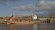
Although ships no longer dock in the town of Bridgwater, 90213 tonne of cargo were handled within the port authority's area in 2006, most of which was stone products via the wharf at Dunball. It is no longer linked to the railway system. The link was removed as part of the railway closures made as a result of the Beeching Report
in the 1960s. Dunball railway station, which had opened in 1873, was closed to both passengers and goods in 1964. All traces of the station, other than "Station Road" have been removed. The wharf is now used for landing stone products, mainly marine sand and gravels dredged in the Bristol Channel
. Marine sand and gravel accounted for 55754 tonne of the total tonnage of 90213 tonne using the Port facilities in 2006, with salt products accounting for 21170 tonne in the same year, while the roll-on roll-off berth at Combwich is used occasionally for the transfer of heavy goods for the two existing Hinkley Point nuclear power stations. With the possible future construction of the two Hinkley Point C nuclear power station
s by EDF Energy
, it is proposed that Combwich wharf be employed to transfer heavy goods to the sites. Combwich Pill is the only site where recreational moorings are available in the estuary.
Sedgemoor District Council
acts as the Competent Harbour Authority for the port, and has provided pilotage services
for all boats over 98 feet (30 m) using the river since 1998, when it took over the service from Trinity House
. Pilotage is important because of the constant changes in the navigable channel resulting from the large tidal range, which can exceed 39 feet (11.9 m) on spring tides. Most commercial shipping travels upriver as far as Dunball wharf, which handles bulk cargoes.
to Long Load Bridge and Ilchester. The channel below the junction with the River Tone
had been improved as a result of Acts of Parliament passed in 1699 and 1707, "for making and keeping the River Tone navigable from Bridgewater to Taunton", and a third act with a similar purpose was passed in 1804. Traffic on the higher reaches was hindered by shoal
s in the river, and by the Great Bow Bridge at Langport, which consisted on nine small arches, none of them big enough for navigation. All cargoes heading upstream had to be off-loaded from the bigger barges, carried to the other side of the bridge, and reloaded into the smaller barges. Traffic above Langport was sporadic, as the water levels were often inadequate, forcing boats to wait several days for the right conditions before proceeding.
The abortive Ivelchester and Langport Navigation
scheme had sought to avoid the Great Bow Bridge, by making the Portlake Rhine navigable, rebuilding Little Bow Bridge in the centre of Langport, and making a new cut to Bicknell's Bridge. Seven locks, each with a small rise, were planned but the scheme foundered in 1797, due to financial difficulties. After the cessation of hostilities with France at the beginning of the 19th century, there was renewed interest in canal building in Somerset; the Bridgwater and Taunton Canal
was authorised in 1824, the Glastonbury Canal
in 1827, and the Chard Canal
in 1834.
When the Bridgwater and Taunton Canal was opened in 1827 it joined the Parrett by a lock at Huntworth
, where a basin
was constructed, but in 1841 the canal was extended to the new floating harbour in Bridgwater, and the Huntworth link was filled in. The canal and river were not re-connected at this point when the canal was restored, because the tidal Parrett, at Huntworth, is a salt water
river laden with silt, whereas the canal contains fresh water
. Not only is there a risk of silt entering the canal, but the salt water cannot be allowed to contaminate the fresh, as the canal is still used for the transport of drinking water
for Bridgwater's population.
, who together operated a river freight business, commissioned the engineer Joseph Jones to carry out a survey for the Parrett Navigation which was then put before Parliament. It was supported by Brunel
and a large quantity of documentary evidence. Objections from local landowners were handled by including clauses in the Parrett Navigation Act to ensure that surplus water would be channelled to the Long Sutton Catchwater Drain by culverts, siphons, and sluices, and the Act of Parliament was passed on 4 July 1836.
The Parrett Navigation Act allowed the proprietors, of which 25 were named, to raise £10,500 in shares and £3,300 by mortgage, with which to make improvements to the river from Burrow Bridge to Langport, to reconstruct the restrictive bridge at Langport, and to continue the improvements as far as Thorney. The River Isle
, which joined the Parrett at Muchelney
, was to be improved for its first mile, and then the Westport Canal
was to be constructed from there to Westport. Locks were planned at Stanmoor, Langport, and Muchelney, with a half-lock at Thorney. An extra lock was added at Oath, when tests revealed that the depth of water would not meet that specified in the Act without it. Costs were considerably higher than expected, and a second Act of Parliament was obtained in 1839, to allow an extra £20,000 to be raised. The lock at Oath has since been replaced by a sluice gate to control flooding.
The section below Langport was completed and opened on 28 October 1839; the section to Thorney and the Westport Canal were completed in August 1840. The Langport Bridge was not finished until March 1841; of the £3,749 cost of construction, £500 came from the Langport Corporation and the rest was raised by a bridge toll operated from March 1841 until January 1843. The total cost of the works was £38,876, and no dividends were paid until 1853, as all profits were used to repay the loans which had been taken out. There are no records of traffic, but it has been estimated at 60000 long ton per year, based on the toll receipts and the knowledge that the Stuckey and Bagehot boats carried about three quarters of the total tonnage.
built in 1871 to the design of Sir Francis Fox
, the engineer for the Bristol and Exeter Railway. It carried a broad gauge
(later a standard gauge
) railway siding over the river to the docks, but had to be movable, to allow boats to proceed upriver. An 80 feet (24.4 m) section of railway track to the east of the bridge could be moved sideways, so that the main 127 feet (38.7 m) girders could be retracted, creating a navigable channel which was 78 feet (23.8 m) wide. It was manually operated for the first eight months, and then powered by a steam engine, reverting to manual operation in 1913, when the steam engine failed. The bridge was last opened in 1953, and the traverser section was demolished in 1974, but public outcry at the action resulted in the bridge being listed as a Scheduled Ancient Monument
, and the rest of the bridge was kept. It was later used as a road crossing, until the construction of the Chandos road bridge alongside it, and is now only used by pedestrians. Parts of the steam engine were moved to Westonzoyland Pumping Station Museum in 1977.
The next bridge is the Town Bridge. There has been a bridge here since the 13th century, when Bridgwater was granted a charter by King John
. The present bridge was designed by R. C. Else and G. B. Laffan, and the 75 feet (22.9 m) cast iron
structure was completed in 1883. It replaced an earlier iron bridge, which was the first cast iron bridge to be built in Somerset
when it was completed in 1797. The stone abutments of that bridge were reused by the later bridge, which formed the only road crossing of the river in Bridgwater until 1958. Above the bridge there were two shoals, called The Coals and The Stones, which were a hazard to barge traffic on the river, and bargees had to choose carefully when to navigate the river, to ensure that there was sufficient water to carry them over these obstructions. In March 1958 a new reinforced concrete road bridge, the Blake Bridge, was opened as part of a bypass to take traffic away from the centre of Bridgwater. It now carries the A38 and A39 roads. On the southern edge of Bridgwater is a bridge which carries the Bristol and Exeter Railway across the River Parrett. Isambard Kingdom Brunel
designed a brick bridge, known as the Somerset Bridge, with a 100 feet (30.5 m) span but a rise of just 12 feet (3.7 m). Work started in 1838 and was completed in 1841. Brunel left the centring scaffold in place as the foundations were still settling but was forced to remove it in 1843 to reopen the river for navigation. Brunel demolished the brick arch and had replaced it with a timber arch within six months without interrupting the traffic on the railway. This was in turn replaced in 1904 by a steel girder bridge. Slightly further east is a modern concrete bridge which carries the M5 motorway
over both the river and the railway line. It was started in 1971 and opened in 1973.
Before 1826, the bridge at Burrowbridge
, just below the junction with the River Tone
, consisted of three arches, each only a little wider than the barges which used the river. They restricted the flow of water in times of flood, and made navigation difficult. The bridge was highlighted in a report made by William Armstrong in 1824, as a factor which would prevent the River Tone Navigation competing with the new Bridgwater and Taunton Canal, then being built. An Act of Parliament was obtained in 1824 by the Turnpike Commissioners, authorising the construction of a new bridge and the removal of the old. A design for a 70-foot (21 m) single span bridge in cast iron
was dropped because of the cost of cast iron at the time, and instead a stone bridge was built, which was completed in 1826. This is the longest single span masonry road bridge in the county, and was also the last toll bridge
in Somerset, until it was 'freed' in 1946. It now carries the A361 road
. Just below the bridge there was a shoal of rocks and stones, which was also mentioned in Armstrong's report, but no action was taken to remove it. Except on spring tides, Burrowbridge was the normal upper limit for barges riding the incoming tide. Above here, horses were used to pull the boats, either towards Langport or along the River Tone towards Taunton.
Stanmoor lock was constructed after the junction with the River Tone, but all traces of it have gone. Next to the pedestrian bridge at Stathe four living willow cones, which were woven in 1997 by Clare Wilks, have now rooted and sprouted. Oath lock no longer functions as a lock, but the sluice is used to regulate the river levels. Below Langport
, the river is crossed by a lattice girder bridge, carrying the Taunton to Westbury railway line
, which approaches the crossing on multi-arched viaducts. This is followed by the derelict remains of the Langport lock and sluice.
At Langport, the Great Bow Bridge, which now carries the A378, is a three-arched bridge, constructed under the terms of the Parrett Navigation Act of 1836. Completed in 1841 at a cost of £3,749, it replaced the previous medieval bridge, with its nine tiny arches, all too small to allow navigation. A bridge at this site was first mentioned in 1220. The medieval bridge consisted of a total of 31 arches, of which nine crossed the river, and 19 of the original arches were located by ground-penetrating radar in 1987, buried beneath the road which runs from Great Bow Bridge to Little Bow Bridge. The Warehouse
in Langport was built in the late 18th century of English bond red brick, with Flemish bond extensions. It has clay plain tile roofs with hipped
ends. It was built by the Parrett Navigation Company
, a trading Company owned by Vincent Stuckey and Walter Bagehot
, on the banks of the River. When the river became unnavigable, the usefulness of the building waned and it was eventually abandoned. The Somerset Trust for Sustainable Development, which became the Ecos Trust, purchased the site, designated as a brown field site
, in February 2003, and worked with Somerset Buildings Preservation Trust
, English Heritage
and local councils to redevelop it into a craft, heritage learning and small business centre, with the surrounding land being used for an eco-friendly housing development. It is a grade II listed building.
The newest bridge across the Parrett is Cocklemoor Bridge, a pedestrian footbridge close to the Great Bow Bridge, that was erected in 2006 and forms part of the River Parrett Trail
. The next bridge upstream is Bicknell's bridge, which was formerly known as Bickling bridge, which carries the road from Huish Episcopi
to Muchelney
. It replaced a footbridge in 1829 or 1830. At Muchelney the Westover Bridge carries a minor road over the river, and another minor road crosses on the Thorney Bridge close to the Thorney (or silent) Mill and a lock. The mill, with an iron overshot wheel, which was built to grind corn in 1823. Another bridge and mill occurs further upstream at Gawbridge west of Martock
, where the mill has been the subject of a feasibility study by the South Somerset Hydropower Group
. Carey's Mill Bridge was built of Ham stone in the 18th century and named after Carey's Mill which originally occupied the site. It is surrounded by a collection of buildings known as the Parrett Iron Works
, founded in 1855, on the site of a former snuff
mill, which included a foundry, with a prominent chimney, ropewalk
, workshops and several smaller workshops and cottages. The sluice which powered the waterwheel and sluice keepers cottage still exist. Further south the river flows under the A303 road
near Norton Sub Hamdon
and the A356 near Chedington
.
, which are heavily laden with silt, flow into the lower reaches of the Parrett and the Tone on each tide. This silt can rapidly gather on the banks of the rivers reducing the capacity and performance of the channel, and increasing the risk of flooding of surrounding land.
The river is technically a highland carrier, as it is embanked and the water level is often higher than that of the land through which it flows. Water from the surrounding countryside does not therefore drain into the river naturally, and drainage schemes have relied on pumping to remove the water. The pumping station at Westonzoyland
was built in 1830, the first mechanical pumping station
on the Somerset Levels. It was designed to drain the area around Westonzoyland, Middlezoy
and Othery
, and the success of the drainage system
led to the formation of Internal drainage board
s and the construction of other pumping station
s.
The pump at Westonzoyland originally comprised a beam engine
and scoop wheel
, which is similar to a water wheel, except that it is driven round by the engine and lifts water up to a higher level. After 25 years, there were problems pumping the water away as the land surface had dropped as it dried out. A better method was sought, and in 1861 a replacement pump was installed. The engine was built by Easton and Amos of London, to a design patented in 1858 by Charles Amos. It is a twin cylinder, vertical condensing engine, driving a centrifugal pump
. A similar engine was on display at the Great Exhibition of 1851
and was shown to be able to lift 100 tons of water per minute (1,700 L/s), to a height of 6 feet (1.8 m). The Westonzoyland pump lifts water from the rhyne
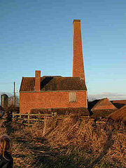
into the River Parrett. The pump operated until 1951, when a new diesel-powered pumping station, capable of pumping 35 tons per minute (600 L/s) at any state of the tide, was built beside the old one. The pumping station is now an Industrial Heritage museum of steam powered machinery and land drainage, and houses most of the equipment from the disused Burrowbridge pumping station.
The Somerset River Authority was established in the 1960s, and later became part of Wessex Water
. Tidal models were used to explore the relationship between any improvement to the river to reduce the likelihood of flooding and subsequent silting reducing the effects. Engineering works were undertaken at the Parrett, King's Sedgemoor Drain, and River Brue
systems, in an attempt to ensure that agricultural land benefited from a potable water supply in the groundwaters from the Quantock Hills
to the coastline.
Various measures including sluice gates, or clyce, have been deployed to try and control flooding. Completed in 1972, the Sowy River
is a 7.5 miles (12.1 km) embanked channel which starts at Monks Leaze clyce below Langport, and carries excess water from the river to the Kings Sedgemoor Drain, from where it flows to the estuary by gravity, rejoining the Parrett near Dunball wharf. Construction of the channel, together with improvements to the Kings Sedgemoor Drain and the rebuilding of the clyce at Dunball, to create a fresh water seal which prevents salt water entering the drain from the river, cost £1.4 million. The scheme has resulted in less flooding on Aller Moor.
In the 1970s a study was commissioned by Wessex Water to investigate the likely effects of constructing a tide-excluding barrier, aimed at stopping the silt, just upriver of Dunball Wharf on the hydraulic, sedimentary and pollutant regime of the estuary. Results showed that a site further upriver could be viable.
The area around the estuary, known as Parrett Reach, around the Steart Peninsula has flooded many times during the last millennium. As a result, the Environment Agency
, a non-departmental public body
of the UK government's Department for Environment, Food and Rural Affairs, produced the Stolford to Combwich Coastal Defence Strategy Study in 2002, to examine options for the future. In July 2010 the Environment Agency presented plans to convert the peninsula into wetland habitat, if the proposed scheme goes ahead it will be the largest wetland habitat creation scheme in England.
Following summer floods of 1997 and the prolonged flooding of 1999/2000 the Parrett Catchment Project was formed, partly funded by the European Union
Regional Development Fund
, by 30 organisations, including; British Waterways
, Campaign to Protect Rural England, The Countryside Agency, Department for Environment, Food and Rural Affairs
, Environment Agency
, Kings Sedgemoor and Cary Vale Internal Drainage Board (now part of Parrett Internal Drainage Board), Levels and Moors Partnership, National Farmers Union, Sedgemoor
, Somerset County Council
, South Somerset District Council, Taunton Deane
and Wessex Water. They aim to tackle 12 areas, which, when combined, will make a significant contribution to reducing the adverse effects of flooding. These include the conversion of arable land, adoption of the Sustainable Drainage Systems (SuDS) approach to controlling rainwater runoff from developed areas, dredging, raising riverbanks and improving pumping facilities. Further studies of the possible beneficial effects of woodland in reducing flooding have also been undertaken.
clay over Yeovil sands. The resulting light soil made the area important for the production of flax
and for market gardening in the past.
 Burrow Mump
, an ancient earthwork owned by the National Trust
, is a natural hill of Triassic
sandstone
capped by Keuper marl
, standing at a strategic point where the River Tone
and the old course of the River Cary
join the River Parrett. It probably served as a natural outwork to the defended royal island of Athelney
at the end of the 9th century.
The Levels and Moors are a largely flat area in which there are some slightly raised parts, called "burtles" as well as higher ridges and hills. It is an agricultural region typically with open fields of permanent
grass, surrounded by ditches lined with willow
trees. Access to the Levels and Moors is by "droves", i.e. green lanes. The Levels are a coastal sand and clay barrier about 20 feet (6 m) above mean sea level (roughly west of the M5 motorway) whereas the inland Moors can be 20 feet (6 m) below peak tides and have large areas of peat
. The geology of the area is that of two basins mainly surrounded by hills, the runoff from which forms rivers that originally meandered across the plain but have now been controlled by embanking and clyces. The area is prone to winter floods of fresh water and occasional salt water inundations which have occurred, the worst of which in recorded history was the Bristol Channel floods of 1607
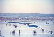
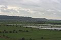
, which resulted in the drowning of an estimated 2,000 or more people, with houses and villages swept away, an estimated 200 square miles (518 km²) of farmland inundated and livestock destroyed. A further severe flood occurred in 1872–1873 when over 107 square miles (277 km²) were under water from October to March.
The extraction of peat
from the Moors is known to have taken place during Roman
times, and has been an ongoing practice since the levels were first drained. The introduction of plastic packaging in the 1950s allowed the peat to be packed without rotting. This led to the industrialisation of peat extraction during the 1960s as a major market in horticultural peat was developed. The reduction in water levels that resulted put local ecosystem
s at risk; peat wastage in pasture fields was occurring at rates of 1–3 ft (0.3–0.8 m) over 100 years.
From January until May, the Parrett provides a source of European Eel
s (Anguilla anguilla) and young elvers, which are caught by hand netting as this is the only legal means of catching them. A series of eel passes have been built on the Parrett at the King's Sedgemoor Drain to help this endangered species; cameras have shown 10,000 eels migrating upstream in a single night. The 2003 BBC Radio 4
play Glass Eels by Nell Leyshon
was set on the Parrett.
To the north of the river bank northwest of Langport are the Aller and Beer Woods
and Aller Hill
biological Sites of Special Scientific Interest
(SSSI). Aller and Beer Woods is a Somerset Wildlife Trust
reserve. It consists of large blocks of semi-natural ancient woodland
along the west-facing slope of Aller Hill, overlooking King's Sedgemoor. The reserve is about 40 hectares (98.8 acre) and the underlying geology of most of it is Lias limestone
. Prior to the 20th century it appears to have been managed for centuries as traditional coppice woodland, and provides an outstanding example of ancient escarpment woodland. The woodland is a variant of the Calcareous Ash
/Wych Elm
stand-type, with Pedunculate Oak
(Quercus robur), and Ash (Fraxinus excelsior) the dominant canopy trees throughout, and with scattered concentrations of Wych Elm (Ulmus glabra). Ancient woodland indicators include Small-leaved Lime
(Tilia cordata), and Wild Service Tree
(Sorbus torminalis), both of which are locally common. Plants of particular interest include Bird's Nest Orchid (Neottia nidus-avis), Greater Butterfly Orchid (Platanthera chlorantha) and the very rare Red Data Book species Purple Gromwell (Lithospermum purpurocaeruleum). Aller Hill contains three species of plant which are nationally rare and a further three which are of restricted distribution in Somerset. The central area contains a sward dominated by Sheep's Fescue
(Festuca ovina) in combination with Yellow Oat-grass (Trisetum flavescens) and Quaking-grass
(Briza media). Salad Burnet
(Sanguisorba minor) forms a major component of the sward with the two nationally rare species Rough Marsh-mallow (Althaea hirsuta) and Nit-grass (Gastridium ventricosum), also present.
Southlake Moor
is another SSSI, which forms part of an extensive grazing marsh and ditch system. When conditions in the River Parrett are suitable, the moor can be deliberately flooded in winter by opening a sluice in the river's floodbank. Some 96 species of aquatic and bankside vascular plant species have been recorded on Southlake Moor, including the Greater water-parsnip
(Sium latifolium). When the moor is flooded it can be occupied by large numbers of wildfowl; up to 22,000 Wigeon (Anas penelope), 250 Bewick's Swan
(Cygnus bewickii) and good numbers of Pochard (Aythya ferina), Teal
(Anas crecca) and Tufted Duck
(Aythya fuligula). Signs of European Otter
s (Lutra lutra) are regularly seen on the muddy banks of the River Parrett. The ditches on the east side of the site are populated by Palmate Newt
s (Triturus helveticus).
Langmead and Weston Level
is nationally important for its species-rich neutral grassland
and the invertebrate
community found in the ditches and rhynes. The terrestrial and aquatic invertebrates recorded on the site include four nationally
rare species: the Great Silver Diving Beetle (Hydrophilus piceus), the soldier fly Odontomyia ornata, which is now called the Ornate Brigadier, and two other flies
, Lonchoptera scutellata and Stenomicra cogani.
The Parrett then flows through the Somerset Levels National Nature Reserve which contains a rich biodiversity
of national and international importance. It supports a vast variety of plant species, including common plants such as Marsh Marigold (Caltha palustris), Meadowsweet
(Filipendula ulmaria) and Ragged Robin
(Lychnis flos-cuculi). The area is an important feeding ground for birds including Bewick’s Swan (Cygnus columbianus bewickii), Eurasian Curlew
(Numenius arquata), Common Redshank
(Tringa totanus), Skylark
(Alauda arvensis), Common Snipe
(Gallinago gallinago), Common Teal
(Anas crecca), Eurasian Wigeon (Anas penelope) and Whimbrel
(Numenius phaeopus), as well as birds of prey including the Western Marsh Harrier
(Circus aeruginosus) and Peregrine Falcon
(Falco peregrinus). A wide range of invertebrate
species is also present including rare insects, particularly the Hairy Click Beetle (Synaptus filiformis) which until recently was only known in Britain from the Parrett, and other insects, including the Lesser Silver Water Beetle
(Hydrochara caraboides), Bagous nodulosus, Hydrophilus piceus, Odontomyia angulata, Oulema erichsoni and Valvata macrostoma
. In addition, the area supports an important European Otter
(Lutra lutra) population. Two-hundred-eighty-two American Mink
(Mustela vison) have been captured, after their escape from breeding farms which is encouraging Water Voles (Arvicola amphibius) to recolonise areas of the Levels where they have been absent for 10 years. The Levels and Moors include 32 Sites of Special Scientific Interest
(twelve of them also Special Protection Area
s), the Huntspill River and Bridgwater Bay
National Nature Reserves
, the Somerset Levels and Moors Ramsar Site covering about 86000 acres (348 km²), the Somerset Levels National Nature Reserve, Shapwick Heath National Nature Reserve
, and numerous Scheduled Ancient Monument
s. In addition, some 72000 acres (291.4 km²) of the Levels are recognised as an Environmentally Sensitive Area
, while other portions are designated as Areas of High Archaeological Potential. Despite this, there is currently no single conservation designation
covering the entire area of the Levels and Moors.
On the outskirts of Bridgwater at Huntworth
the river passes the Screech Owl local nature reserve where flooded clay pits provide a roost for thousands of Common Starlings (Sturnus vulgaris) each winter. The mouth of the river is where it flows into the National Nature Reserve
at Bridgwater Bay
on the Bristol Channel
. It consists of large areas of mud flats, saltmarsh, sandflats and shingle ridges, some of which are vegetated. It has been designated as a Site of Special Scientific Interest
since 1989, and is designated as a wetland of international importance under the Ramsar Convention
. The risks to wildlife are highlighted in the local Oil Spill Contingency Plan.
, Muchelney Abbey, West Sedgemoor
(a Site of Special Scientific Interest
(SSSI), the Blake Museum, Westonzoyland Pumping Station Museum, the site of the Battle of Sedgemoor
and finally discharging into Bridgwater Bay (another SSSI). The Langport and River Parrett Visitor Centre located at Langport details local life, history and wildlife.
Since 2000 attempts have been made to clarify the legal status and organisational responsibilities for the maintenance of the river and explore issues involving the sustainability and safe use of the waterway for a public trip boat and recreational craft. The work has identified economic and social benefits from the development of the Parrett navigation.
Dorset
Dorset , is a county in South West England on the English Channel coast. The county town is Dorchester which is situated in the south. The Hampshire towns of Bournemouth and Christchurch joined the county with the reorganisation of local government in 1974...
and Somerset
Somerset
The ceremonial and non-metropolitan county of Somerset in South West England borders Bristol and Gloucestershire to the north, Wiltshire to the east, Dorset to the south-east, and Devon to the south-west. It is partly bounded to the north and west by the Bristol Channel and the estuary of the...
in South West England
South West England
South West England is one of the regions of England defined by the Government of the United Kingdom for statistical and other purposes. It is the largest such region in area, covering and comprising Bristol, Gloucestershire, Somerset, Dorset, Wiltshire, Devon, Cornwall and the Isles of Scilly. ...
, from its source in the Thorney Mills springs
Spring (hydrosphere)
A spring—also known as a rising or resurgence—is a component of the hydrosphere. Specifically, it is any natural situation where water flows to the surface of the earth from underground...
in the hills around Chedington
Chedington
Chedington is a hamlet in west Dorset, England, situated on the A356 road four miles south east of Crewkerne. The village has a population of 82 and is administered as part of Parrett and Axe Parish Council....
in Dorset. Flowing northwest through Somerset and the Somerset Levels
Somerset Levels
The Somerset Levels, or the Somerset Levels and Moors as they are less commonly but more correctly known, is a sparsely populated coastal plain and wetland area of central Somerset, South West England, between the Quantock and Mendip Hills...
to its mouth at Burnham-on-Sea
Burnham-on-Sea
Burnham-on-Sea is a town in Somerset, England, at the mouth of the River Parrett and Bridgwater Bay. Burnham was a small village until the late 18th century, when it began to grow because of its popularity as a seaside resort. It forms part of the parish of Burnham-on-Sea and Highbridge...
, into the Bridgwater Bay
Bridgwater Bay
Bridgwater Bay is on the Bristol Channel, north of Bridgwater in Somerset, England at the mouth of the River Parrett and the end of the River Parrett Trail. It consists of large areas of mud flats, saltmarsh, sandflats and shingle ridges, some of which are vegetated...
Nature Reserve
National Nature Reserves in England
National Nature Reserves in England are managed by Natural England and are key places for wildlife and natural features in England. They were established to protect the most important areas of habitat and of geological formations...
on the Bristol Channel
Bristol Channel
The Bristol Channel is a major inlet in the island of Great Britain, separating South Wales from Devon and Somerset in South West England. It extends from the lower estuary of the River Severn to the North Atlantic Ocean...
, the Parrett and its tributaries drain an area of 1700 square kilometres (656.4 sq mi) – about 50 per cent of Somerset's land area, with a population of 300,000.
The Parrett's main tributaries include the Rivers Tone
River Tone
The River Tone is a river in Somerset, England, which is about long. It rises at Beverton Pond near Huish Champflower in the Brendon Hills, and is dammed at Clatworthy Reservoir. The reservoir outfall continues through Taunton and Curry and Hay Moors, which are designated as a Site of Special...
, Isle
River Isle
The River Isle flows from its source near Combe St Nicholas, through Somerset, England and discharges into the River Parrett south of Langport near Midelney....
, and Yeo
River Yeo (South Somerset)
The River Yeo, also known as the River Ivel or River Gascoigne, is a tributary of the River Parrett in north Dorset and south Somerset, England....
, and the River Cary
River Cary
The River Cary is a river in Somerset, England.The River Cary has its source at Park Pond in Castle Cary, and then flows southwest through Cary Moor to Babcary, where there is a biological Site of Special Scientific Interest at Babcary Meadows and Cary Fitzpaine. It then flows northwest through...
via the King's Sedgemoor Drain
King's Sedgemoor Drain
King's Sedgemoor Drain is an artificial drainage channel which diverts the River Cary in Somerset, England along the southern flank of the Polden Hills, to discharge into the River Parrett at Dunball near Bridgwater. As the name suggests, the channel is used to help drain the peat moors of King's...
. The 37 miles (60 km) long river is tidal for 27 miles (43 km) up to Oath. Because the fall of the river between Langport
Langport
Langport is a small town and civil parish in Somerset, England, situated west of Somerton in the South Somerset district. The town has a population of 1,067. The parish includes the hamlets of Bowdens and Combe...
and Bridgwater
Bridgwater
Bridgwater is a market town and civil parish in Somerset, England. It is the administrative centre of the Sedgemoor district, and a major industrial centre. Bridgwater is located on the major communication routes through South West England...
is only 1 ft/mi, it is prone to frequent flooding in winter and during high tides. Many approaches have been tried since at least the medieval period to reduce the incidence and effect of floods and to drain the surrounding fields.
In Anglo-Saxon
Anglo-Saxon
Anglo-Saxon may refer to:* Anglo-Saxons, a group that invaded Britain** Old English, their language** Anglo-Saxon England, their history, one of various ships* White Anglo-Saxon Protestant, an ethnicity* Anglo-Saxon economy, modern macroeconomic term...
times the river formed a boundary between Wessex
Wessex
The Kingdom of Wessex or Kingdom of the West Saxons was an Anglo-Saxon kingdom of the West Saxons, in South West England, from the 6th century, until the emergence of a united English state in the 10th century, under the Wessex dynasty. It was to be an earldom after Canute the Great's conquest...
and Dumnonia
Dumnonia
Dumnonia is the Latinised name for the Brythonic kingdom in sub-Roman Britain between the late 4th and late 8th centuries, located in the farther parts of the south-west peninsula of Great Britain...
. It later served the Port of Bridgwater, and enabled cargoes to be transported inland. The arrival of the railways led to a decline in commercial shipping and the only working docks are at Dunball
Dunball
Dunball is a small hamlet west of the village of Puriton and close to the town of Bridgwater, Somerset, England.Just north of Dunball is Down End which is the site of Down End Castle a motte-and-bailey castle, which has been designated as a Scheduled Ancient Monument.Located on the A38, adjacent to...
. Man's influence on the river has left a legacy of bridges and industrial artefacts. The Parrett along with its connected waterways and network of drains supports an ecosystem that includes several rare species of flora and fauna. The River Parrett Trail
River Parrett Trail
The River Parrett Trail is a long-distance footpath, following the route of the River Parrett in Somerset, England. The trail, which is long, runs from Chedington in Dorset to the mouth of the river in Bridgwater Bay where it joins the West Somerset Coast Path....
has been established along the banks of the river.
Course
The River Parrett is 37 miles (60 km) long, flowing roughly south to north from DorsetDorset
Dorset , is a county in South West England on the English Channel coast. The county town is Dorchester which is situated in the south. The Hampshire towns of Bournemouth and Christchurch joined the county with the reorganisation of local government in 1974...
through Somerset. Its source is in the Thorney Mills springs
Spring (hydrosphere)
A spring—also known as a rising or resurgence—is a component of the hydrosphere. Specifically, it is any natural situation where water flows to the surface of the earth from underground...
in the hills around Chedington
Chedington
Chedington is a hamlet in west Dorset, England, situated on the A356 road four miles south east of Crewkerne. The village has a population of 82 and is administered as part of Parrett and Axe Parish Council....
, 2.5 miles (4 km) from that of the River Axe, in nearby Beaminster
Beaminster
Beaminster is a small town and civil parish in the West Dorset district of Dorset in South West England, at the head of the valley of the River Brit. Beaminster is south of Bristol, west of Bournemouth, east of Exeter and northwest of the county town of Dorchester...
, which runs in the opposite direction to the English Channel
English Channel
The English Channel , often referred to simply as the Channel, is an arm of the Atlantic Ocean that separates southern England from northern France, and joins the North Sea to the Atlantic. It is about long and varies in width from at its widest to in the Strait of Dover...
at Axmouth
Axmouth
Axmouth is a village and civil parish in the East Devon district of Devon, England, near the mouth of the River Axe. The village itself is about 1 km inland, although the parish extends to the sea. The village is near Seaton and Beer...
in Devon. The two rivers give their names to Parrett and Axe Parish Council.
From its source, the Parrett runs north through South Perrott
South Perrott
South Perrott is a village in northwest Dorset, England, two miles south east of Crewkerne. The village has a population of 247 .The name Perrott comes from the River Parrett.The manor was held with North Perrott just over the border in Somerset....
and under the Salisbury to Exeter railway line
West of England Main Line
The West of England Main Line is a British railway line that runs from , Hampshire to Exeter St Davids in Devon, England. Passenger services run between London Waterloo station and Exeter...
before passing to the west of North Perrott
North Perrott
North Perrott is a village and civil parish in the South Somerset district of the English county of Somerset.-History:The name Perrott comes from the River Parrett.There is evidence of Roman and Iron Age settlement in the village....
and Haselbury Plucknett
Haselbury Plucknett
Haselbury Plucknett is a village and civil parish on the River Parrett in Somerset, England, situated south west of Yeovil in the South Somerset district. The village has a population of 641....
. It then runs through fields between Merriott
Merriott
Merriott is a village and civil parish in Somerset, England, near the town of Crewkerne and west of Yeovil in the South Somerset district. The village has a population of 2,020....
to the west and West Chinnock
West Chinnock
West Chinnock is a village in Somerset, England, situated near the A356 road north east of Crewkerne in the South Somerset district. The village forms the civil parish of West and Middle Chinnock with the neighbouring village of Middle Chinnock. The parish has a population of 564 .Middle...
and Chiselborough
Chiselborough
Chiselborough is a village situated on the river Parrett west of Yeovil in Somerset, England. The village has a population of 335.The village consists largely of small cottages built in the local golden hamstone quarried at the local Ham Hill.-History:...
to the east. Passing under the A303 road
A303 road
The A303 is a 92-mile long trunk road in England. It is the main road between Basingstoke in Hampshire and Honiton in Devon. The M3, the A303 and the A30 together make up one of the main routes from London to South West England, running from London to Land's End in Cornwall...
to the east of South Petherton
South Petherton
South Petherton is a small country town and civil parish on the River Parrett in the South Somerset district of Somerset, England. It is east of Ilminster and north west of Crewkerne. It had a population of approximately 3,200 in 2002...
, the river flows between East Lambrook and Bower Hinton west of Martock
Martock
Martock is a large village and civil parish in Somerset, England, situated on the edge of the Somerset Levels north west of Yeovil in the South Somerset district. The parish includes Hurst, approximately one mile south of the village, and Bower Hinton, which is located at the western end of the...
and then towards Kingsbury Episcopi
Kingsbury Episcopi
Kingsbury Episcopi is a village and civil parish on the River Parrett in Somerset, England, situated north west of Yeovil in the South Somerset district. The village has a population of 1,277. The parish includes the villages of West Lambrook, East Lambrook and Thorney.-History:The "Episcopi"...
, through Thorney and Muchelney
Muchelney
Muchelney is a village and civil parish in Somerset, England, on the River Parrett, south of Huish Episcopi and miles south west of Somerton in the South Somerset district...
, passing the remains of Muchelney Abbey
Muchelney Abbey
Muchelney Abbey is an English Heritage property in the village of Muchelney in the Somerset Levels, England.It comprises the remains and foundations of a medieval Benedictine abbey, the site of an earlier Anglo-Saxon abbey, and an early Tudor house dating from the 16th century, formerly the...
before entering Langport
Langport
Langport is a small town and civil parish in Somerset, England, situated west of Somerton in the South Somerset district. The town has a population of 1,067. The parish includes the hamlets of Bowdens and Combe...
, which is about 10 miles (16.1 km) north of Chiselborough. Below Thorney Bridge the river's banks have been raised to mitigate flooding.
The Parrett then flows northwest for approximately another 10 miles (16.1 km) to Bridgwater through the Somerset Levels
Somerset Levels
The Somerset Levels, or the Somerset Levels and Moors as they are less commonly but more correctly known, is a sparsely populated coastal plain and wetland area of central Somerset, South West England, between the Quantock and Mendip Hills...
past Aller
Aller, Somerset
Aller is a village and parish in Somerset, England, situated west of Somerton on the A372 road towards Bridgwater in the South Somerset district. The village has a population of 374...
, close to the Aller and Beer Woods
Aller and Beer Woods
Aller and Beer Woods is a biological Site of Special Scientific Interest. off the A372 Othery to Langport road near Aller in Somerset. It was notified in 1952....
and Aller Hill
Aller Hill
Aller Hill is a 18.4 hectare biological Site of Special Scientific Interest near Aller in Somerset, notified in 1988.The site contains three species of plant which are nationally rare and a further three which are of restricted distribution in Somerset...
biological Sites of Special Scientific Interest
Site of Special Scientific Interest
A Site of Special Scientific Interest is a conservation designation denoting a protected area in the United Kingdom. SSSIs are the basic building block of site-based nature conservation legislation and most other legal nature/geological conservation designations in Great Britain are based upon...
(SSSI). The sluice gate (formerly a lock built in the late 1830s) at the deserted medieval village
Deserted medieval village
In the United Kingdom, a deserted medieval village is a former settlement which was abandoned during the Middle Ages, typically leaving no trace apart from earthworks or cropmarks. If there are fewer than three inhabited houses the convention is to regard the site as deserted; if there are more...
of Oath marks the river's tidal limit. The river then crosses Southlake Moor
Southlake Moor
Southlake Moor is a 196.1 hectare biological Site of Special Scientific Interest near Burrow Mump and Burrowbridge in Somerset, notified in 1985....
. The next major landmark along the river's course is Burrow Mump
Burrow Mump
Burrow Mump is a hill and historic site overlooking Southlake Moor in the village of Burrowbridge in Taunton Deane, Somerset, England. It is a Scheduled Ancient Monument. Burrow Mump is also known as St Michael's Borough or Tutteyate...
, an ancient earthwork owned by the National Trust
National Trust for Places of Historic Interest or Natural Beauty
The National Trust for Places of Historic Interest or Natural Beauty, usually known as the National Trust, is a conservation organisation in England, Wales and Northern Ireland...
. The river then arrives in Burrowbridge
Burrowbridge
Burrowbridge is a village and civil parish in Somerset, England, situated on the River Parrett and A361 road south east of Bridgwater in the Taunton Deane district on the edge of the Somerset Levels...
, where the old pumping station building was once a museum. Flowing north, it passes Langmead and Weston Level
Langmead and Weston Level
Langmead and Weston Level is a 168.8 hectare biological Site of Special Scientific Interest in Somerset, notified in 1991.Langmead and Weston Level form part of the nationally important grazing marsh and ditch systems of the Somerset Levels and Moors...
SSSI, and on past the land-drainage pumping station at Westonzoyland
Westonzoyland Pumping Station Museum
The Westonzoyland Pumping Station Museum is a small Industrial Heritage museum dedicated to steam powered machinery in Westonzoyland, Somerset, England....
.
Further downstream the river passes the village of Huntworth
Huntworth
Huntworth is a small hamlet and farming community , within the civil parish of North Petherton east of the M5 motorway from Bridgwater, Somerset, England....
before flowing under the M5 motorway
M5 motorway
The M5 is a motorway in England. It runs from a junction with the M6 at West Bromwich near Birmingham to Exeter in Devon. Heading south-west, the M5 runs east of West Bromwich and west of Birmingham through Sandwell Valley...
at Dunwear. As it enters Bridgwater it passes under Somerset and Hamp Bridges, and past Bridgwater Castle
Bridgwater Castle
Bridgwater Castle was a castle in the town of Bridgwater, Somerset, England.-Early history:The castle was built in 1202 by William Brewer, like several other castle-builders of the period, an exceptionally wealthy man. He was granted the lordship of the Manor of Bridgwater by King John in 1201, and...
which had a tidal moat
Moat
A moat is a deep, broad ditch, either dry or filled with water, that surrounds a castle, other building or town, historically to provide it with a preliminary line of defence. In some places moats evolved into more extensive water defences, including natural or artificial lakes, dams and sluices...
up to 65 feet (20 m) wide in places, fed by water from the river. From Bridgwater to the sea is approximately 6 miles (9.7 km). The King's Sedgemoor Drain
King's Sedgemoor Drain
King's Sedgemoor Drain is an artificial drainage channel which diverts the River Cary in Somerset, England along the southern flank of the Polden Hills, to discharge into the River Parrett at Dunball near Bridgwater. As the name suggests, the channel is used to help drain the peat moors of King's...
drains into the River Parrett next to the wharf at Dunball; it enters via a clyce
Sluice
A sluice is a water channel that is controlled at its head by a gate . For example, a millrace is a sluice that channels water toward a water mill...
(or clyse), which is a local word for a sluice. The clyce has been moved about 0.3 miles (482.8 m) downstream from its original position and now obstructs the entrance to the small harbour next to the wharf.
The course of the river below Bridgwater is now somewhat straighter than in former times. The village of Combwich
Combwich
Combwich is a village in the parish of Otterhampton within the Sedgemoor district of Somerset, between Bridgwater and the Steart Peninsula.The village lies on Combwich Reach as the River Parrett flows to the sea and was the site of an ancient ferry crossing. In the Domesday book it was known as...
lies adjacent to a channel in the river known as "Combwich Reach"; from here the Parrett flows to the Bristol Channel
Bristol Channel
The Bristol Channel is a major inlet in the island of Great Britain, separating South Wales from Devon and Somerset in South West England. It extends from the lower estuary of the River Severn to the North Atlantic Ocean...
past the Steart Peninsula
Steart Peninsula
The Steart Peninsula is a peninsula in Somerset, England. At its outermost tip is Fenning Island, at the tip of which is Steart Point. It consists largely of low-lying flat farmland, and projects northwards on the west side of Stockland Reach, the lower stretches of the estuary of the River...
. Cartographic
Cartography
Cartography is the study and practice of making maps. Combining science, aesthetics, and technique, cartography builds on the premise that reality can be modeled in ways that communicate spatial information effectively.The fundamental problems of traditional cartography are to:*Set the map's...
evidence indicates that in the early 18th century the peninsula was longer than at present. A "neck" started to form in the peninsula and by 1802 the tip had broken off to form Stert Island. Fenning Island also broke away but has rejoined the peninsula. Much of the peninsula's northern end eroded away or now exists as "islands" visible at low tides within an intertidal area of mud known as the Stert Flats.
The mouth at Burnham-on-Sea
Burnham-on-Sea
Burnham-on-Sea is a town in Somerset, England, at the mouth of the River Parrett and Bridgwater Bay. Burnham was a small village until the late 18th century, when it began to grow because of its popularity as a seaside resort. It forms part of the parish of Burnham-on-Sea and Highbridge...
is a nature reserve
National Nature Reserves in England
National Nature Reserves in England are managed by Natural England and are key places for wildlife and natural features in England. They were established to protect the most important areas of habitat and of geological formations...
where the river flows into Bridgwater Bay
Bridgwater Bay
Bridgwater Bay is on the Bristol Channel, north of Bridgwater in Somerset, England at the mouth of the River Parrett and the end of the River Parrett Trail. It consists of large areas of mud flats, saltmarsh, sandflats and shingle ridges, some of which are vegetated...
on the Bristol Channel. In addition to the rivers Parrett, Brue
River Brue
The River Brue originates in the parish of Brewham in Somerset, England, and reaches the sea some 50 km west at Burnham-on-Sea. It originally took a different route from Glastonbury to the sea, but this was changed by the monastery in the twelfth century....
and Washford, several of the man-made drainage ditches, including the River Huntspill
River Huntspill
The River Huntspill is an artificial river, in the Somerset Levels, in the Sedgemoor district of Somerset, England. It was built in 1940 to supply process water to the armaments factory at Puriton, and has resulted in reduced flooding of the lower Brue Valley.-History:The concept for the Huntspill...
from the Somerset Levels, and the Cannington Brook from the "Pawlett
Pawlett, Somerset
Pawlett is a small village north of Bridgwater, in the Sedgemoor district of the English county of Somerset.The village has Roman or Saxon origins...
Hams", also discharge into the bay.
Flow and tidal bore
The Parrett has only one gauging station, at ChiselboroughChiselborough
Chiselborough is a village situated on the river Parrett west of Yeovil in Somerset, England. The village has a population of 335.The village consists largely of small cottages built in the local golden hamstone quarried at the local Ham Hill.-History:...
, fairly close to the source. It measures flow from the first 29 square miles (75.1 km²) of the drainage basin
Drainage basin
A drainage basin is an extent or an area of land where surface water from rain and melting snow or ice converges to a single point, usually the exit of the basin, where the waters join another waterbody, such as a river, lake, reservoir, estuary, wetland, sea, or ocean...
, or about 4.3 per cent of the total. The mean flow measured by the Environment Agency
Environment Agency
The Environment Agency is a British non-departmental public body of the Department for Environment, Food and Rural Affairs and an Assembly Government Sponsored Body of the Welsh Assembly Government that serves England and Wales.-Purpose:...
at Chiselborough was 1.19 m3/s, with a peak of 173 m3/s on 30 May 1979 and a minimum of 0.07 m3/s over a seven day period in August 1976. Tributaries of the Parrett with gauging stations include the Yeo, Isle, Cary, and Tone.
The lower Parrett has a fall of only 1 ft/mi between Langport and Bridgwater; and it drains into the Bristol Channel. To the northeast of the River Parrett's mouth, the Bristol Channel becomes the Severn Estuary
Severn Estuary
The Severn Estuary is the estuary of the River Severn, the longest river in Great Britain. Its high tidal range means it has been at the centre of discussions in the UK regarding renewable energy.-Geography:...
, which has a tidal range
Tidal range
The tidal range is the vertical difference between the high tide and the succeeding low tide. Tides are the rise and fall of sea levels caused by the combined effects of the gravitational forces exerted by the Moon and the Sun and the rotation of the Earth...
of 14 metres (45.9 ft). The rate and direction of flow of the Parrett is therefore dependent on the state of the tide on the River Severn
River Severn
The River Severn is the longest river in Great Britain, at about , but the second longest on the British Isles, behind the River Shannon. It rises at an altitude of on Plynlimon, Ceredigion near Llanidloes, Powys, in the Cambrian Mountains of mid Wales...
. In common with the lower reaches of the River Severn, the Parrett experiences a tidal bore
Tidal bore
A tidal bore is a tidal phenomenon in which the leading edge of the incoming tide forms a wave of water that travel up a river or narrow bay against the direction of the river or bay's current...
. Certain combinations of the tides funnel the rising water into a wave that travels upstream at about 6 miles per hour (10 km/h), against the river's current.
History
The origin of the name Parrett is unclear, but several derivations from the Celtic languagesCeltic languages
The Celtic languages are descended from Proto-Celtic, or "Common Celtic"; a branch of the greater Indo-European language family...
used in Wales
Wales
Wales is a country that is part of the United Kingdom and the island of Great Britain, bordered by England to its east and the Atlantic Ocean and Irish Sea to its west. It has a population of three million, and a total area of 20,779 km²...
have been suggested. Priestley-Evans suggests "Parrett has been said to be a form of the Welsh
Welsh language
Welsh is a member of the Brythonic branch of the Celtic languages spoken natively in Wales, by some along the Welsh border in England, and in Y Wladfa...
pared, a partition, and that it was the name which the Welsh people of Somerset and Devon gave to that river because it was at one time the dividing line between themselves and the Saxons". Another spelling parwydydd is also translated as partition. Another explanation from Welsh Peraidd meaning the sweet or delicious river, has also been suggested. An alternative explanation, based on Old English, is a derivation from Pedair or Pedride from pedr meaning four and the Old Cornish
Cornish language
Cornish is a Brythonic Celtic language and a recognised minority language of the United Kingdom. Along with Welsh and Breton, it is directly descended from the ancient British language spoken throughout much of Britain before the English language came to dominate...
Rit meaning flow, which in this case would relate to the four flows or streams: the Tone, Yeo, Isle and Parrett. This is based on the explanation given in Ekwall's 1928 book English River Names. Whichever derivation is correct, the name Parrett and its spelling variations have been in use since the Anglo-Saxon
Anglo-Saxon
Anglo-Saxon may refer to:* Anglo-Saxons, a group that invaded Britain** Old English, their language** Anglo-Saxon England, their history, one of various ships* White Anglo-Saxon Protestant, an ethnicity* Anglo-Saxon economy, modern macroeconomic term...
era, as evidenced by the addition of -tun onto river names as seen in the local towns North Petherton
North Petherton
North Petherton is a small town and civil parish in Somerset, England, situated on the edge of the eastern foothills of the Quantocks, and close to the edge of the Somerset Levels.The town has a population of 5,189...
and South Petherton. The spelling Pedred and Pedrida are also mentioned in connection with the Parrett. The Oxford Dictionary of British Place Names states only that the name is a 'pre-English river-name of obscure origin'.
Landscape
The River Parrett, the Bristol Channel and the Severn Estuary are believed to have been used for riverine bulk transportation of people and supplies in Somerset under RomanRoman Empire
The Roman Empire was the post-Republican period of the ancient Roman civilization, characterised by an autocratic form of government and large territorial holdings in Europe and around the Mediterranean....
and later Anglo-Saxon and Norman
Norman dynasty
Norman dynasty is the usual designation for the family that were the Dukes of Normandy and the English monarchs which immediately followed the Norman conquest and lasted until the Plantagenet dynasty came to power in 1154. It included Rollo and his descendants, and from William the Conqueror and...
occupation. Roman Somerset, which lasted for over 250 years until around the beginning of the 5th century, had various settlements, including Bath (Aquae Sulis
Aquae Sulis
Aquae Sulis was a small town in the Roman province of Britannia. Today it is known as Bath, located in the English county of Somerset.-Baths and temple complex:...
), Ilchester
Ilchester
Ilchester is a village and civil parish, situated on the River Yeo or Ivel, five miles north of Yeovil, in the English county of Somerset. The parish, which includes the village of Sock Dennis and the old parish of Northover, has a population of 2,021...
(Lindinis
Lindinis
Lindinis was a small town in the Roman province of Britannia. Today it is known as Ilchester, located in the English county of Somerset....
) and lead mines at Charterhouse
Charterhouse Roman Town
Charterhouse Roman Town was a town in the Roman province of Britannia. Its site is located just to the west of the village of Charterhouse-on-Mendip in the English county of Somerset....
; and four roads surrounding the Somerset Levels. There is evidence of two Roman ports on the Parrett. The port at Combwich, on the west bank, was ill-recorded before its destruction by quarrying and erosion. The other at Crandon Bridge on the east bank near where the current King's Sedgemoor Drain enters the Parrett, was in use between the first and the fourth centuries. Evidence of an extensive site with storehouses was found in the mid 1970s, during motorway construction works. The Crandon Bridge site may have been linked by a probable Roman road over the Polden Hills
Polden Hills
The Polden Hills in Somerset, England are a long, low ridge, extending for , and separated from the Mendip Hills, to which they are nearly parallel, by a marshy tract, known as the Somerset Levels...
to the Fosse Way
Fosse Way
The Fosse Way was a Roman road in England that linked Exeter in South West England to Lincoln in Lincolnshire, via Ilchester , Bath , Cirencester and Leicester .It joined Akeman Street and Ermin Way at Cirencester, crossed Watling Street at Venonis south...
, at Ilchester. Ilchester, the largest Roman town in Somerset, was a port with large granaries
Granary
A granary is a storehouse for threshed grain or animal feed. In ancient or primitive granaries, pottery is the most common use of storage in these buildings. Granaries are often built above the ground to keep the stored food away from mice and other animals.-Early origins:From ancient times grain...
, sited where the Fosse Way crossed the Ilchester Yeo
River Yeo (South Somerset)
The River Yeo, also known as the River Ivel or River Gascoigne, is a tributary of the River Parrett in north Dorset and south Somerset, England....
by means of a paved ford. The Yeo was navigable by small craft all the way to the Parrett allowing military supplies to be brought by boat directly to Ilchester; however, disembarkation at Crandon Bridge and use of the Polden Hills roadway allowed more rapid movement to Ilchester. The Yeo may already have been straightened and canal
Canal
Canals are man-made channels for water. There are two types of canal:#Waterways: navigable transportation canals used for carrying ships and boats shipping goods and conveying people, further subdivided into two kinds:...
ised before Roman occupation.
The Parrett was established as the border between the Anglo-Saxon kingdom of Wessex
Wessex
The Kingdom of Wessex or Kingdom of the West Saxons was an Anglo-Saxon kingdom of the West Saxons, in South West England, from the 6th century, until the emergence of a united English state in the 10th century, under the Wessex dynasty. It was to be an earldom after Canute the Great's conquest...
and the Brythonic
Britons (historical)
The Britons were the Celtic people culturally dominating Great Britain from the Iron Age through the Early Middle Ages. They spoke the Insular Celtic language known as British or Brythonic...
kingdom of Dumnonia
Dumnonia
Dumnonia is the Latinised name for the Brythonic kingdom in sub-Roman Britain between the late 4th and late 8th centuries, located in the farther parts of the south-west peninsula of Great Britain...
in 658, following the Dumnonians' defeat at the Battle of Peonnum
Battle of Peonnum
The Battle of Peonnum was fought approximately AD 660 between the West Saxons under Cenwalh and the Britons of what is now Somerset. It was a decisive victory for the Saxons, who gained control of Somerset as far west as the River Parrett...
that year. This natural border endured for almost a century until further fighting between the Anglo-Saxons and Britons in the mid-8th century, when the border shifted west to its current location between the modern ceremonial counties
Ceremonial counties of England
The ceremonial counties are areas of England to which are appointed a Lord Lieutenant, and are defined by the government as counties and areas for the purposes of the Lieutenancies Act 1997 with reference to the metropolitan and non-metropolitan counties of England and Lieutenancies Act 1997...
of Somerset and Devon
Devon
Devon is a large county in southwestern England. The county is sometimes referred to as Devonshire, although the term is rarely used inside the county itself as the county has never been officially "shired", it often indicates a traditional or historical context.The county shares borders with...
. It is thought a ford, usable only at low tide, crossed the river near its mouth, between Combwich and Pawlett (east bank). This crossing, at the western end of the Polden Hills, was known since Roman times and lay on the route of a Saxon herepath
Herepath
A Herepath or Herewag is a military road in England, typically dating from the ninth century CE.This was a time of war between the Anglo-Saxon kingdoms of southern England and Viking invaders from Denmark...
. It was here, or in the immediate vicinity, that Hubba, the Danish raider, was defeated and killed by Odda of Devon
Odda of Devon
Odda of Devon was the ealdorman of Devon in England in the 9th century, during the reign of Alfred the Great.He was the leader of a Saxon force which defeated a Viking raid in the Battle of Cynuit, England, in 878.- Odda in fiction :...
in 878. In the Domesday Book
Domesday Book
Domesday Book , now held at The National Archives, Kew, Richmond upon Thames in South West London, is the record of the great survey of much of England and parts of Wales completed in 1086...
Combwich was known as Comich, which means "the settlement by the water", from the Old English cumb and wic. The ford was later replaced by a ferry, one was in operation from at least the 13th century. In the 15th century the ferry was regarded as part of the King's Highway; and both passengers and cattle were carried in the 16th and 17th centuries. Records of the joint Manorial
Manorialism
Manorialism, an essential element of feudal society, was the organizing principle of rural economy that originated in the villa system of the Late Roman Empire, was widely practiced in medieval western and parts of central Europe, and was slowly replaced by the advent of a money-based market...
ownership and costs of the ferry exist for 1589 and 1810. The White House Inn, a licensed victualler and part-owner of the ferry, traded on the Pawlett bank from 1655 to 1897; and the building was retained as a farm dwelling for another 20 years. The Combwich river crossing, which was a main route until the 18th century, fell out of use due to turnpike trust
Turnpike trust
Turnpike trusts in the United Kingdom were bodies set up by individual Acts of Parliament, with powers to collect road tolls for maintaining the principal highways in Britain from the 17th but especially during the 18th and 19th centuries...
s improving what were to become the A38
A38 road
The A38, part of which is also known as the Devon Expressway, is a major A-class trunk road in England.The road runs from Bodmin in Cornwall to Mansfield in Nottinghamshire. It is long, making it one of the longest A-roads in England. It was formerly known as the Leeds — Exeter Trunk Road,...
and A39 road
A39 road
The A39 is an A road in south west England. It runs south-west from Bath in Somerset through Wells, Glastonbury, Street and Bridgwater. It then follows the north coast of Somerset and Devon through Williton, Minehead, Porlock, Lynmouth, Barnstaple, Bideford, Stratton, Camelford, Wadebridge and St...
s, and traffic went via Bridgwater; the former inn was demolished c. 1930.
After the departure of the Romans, the low-lying Somerset Levels appear to have been abandoned, as the archaeological record
Archaeological record
The archaeological record is the body of physical evidence about the past. It is one of the most basic concepts in archaeology, the academic discipline concerned with documenting and interpreting the archaeological record....
shows that they were flooded and the former Roman landscape covered with a thick layer of alluvial deposits. Recovery of the levels involved both the construction of sea walls and the containment of the Parrett. Celtic Christianity
Celtic Christianity
Celtic Christianity or Insular Christianity refers broadly to certain features of Christianity that were common, or held to be common, across the Celtic-speaking world during the Early Middle Ages...
came to the remoter areas of the Somerset Levels, making use of "island" sites. Glastonbury Abbey
Glastonbury Abbey
Glastonbury Abbey was a monastery in Glastonbury, Somerset, England. The ruins are now a grade I listed building, and a Scheduled Ancient Monument and are open as a visitor attraction....
, possibly founded in the 7th century (or earlier), was nearby and had undertaken extensive water management to enable it to bring materials by boat to Glastonbury, albeit not via the Parrett. Muchelney Abbey
Muchelney Abbey
Muchelney Abbey is an English Heritage property in the village of Muchelney in the Somerset Levels, England.It comprises the remains and foundations of a medieval Benedictine abbey, the site of an earlier Anglo-Saxon abbey, and an early Tudor house dating from the 16th century, formerly the...
, founded in the mid 8th century, was sited at the confluence of the Parrett and its tributaries, the rivers Isle
River Isle
The River Isle flows from its source near Combe St Nicholas, through Somerset, England and discharges into the River Parrett south of Langport near Midelney....
and Yeo; and Athelney Abbey
Athelney Abbey
Athelney Abbey, established in the county of Somerset, England, was founded by King Alfred in 888, as a religious house for monks of the Order of St. Benedict. It was dedicated to our Blessed Saviour, St. Peter, St. Paul, and St...
lay on another tributary, the River Tone
River Tone
The River Tone is a river in Somerset, England, which is about long. It rises at Beverton Pond near Huish Champflower in the Brendon Hills, and is dammed at Clatworthy Reservoir. The reservoir outfall continues through Taunton and Curry and Hay Moors, which are designated as a Site of Special...
. These three abbeys together with the Bishop of Bath and Wells
Bishop of Bath and Wells
The Bishop of Bath and Wells heads the Church of England Diocese of Bath and Wells in the Province of Canterbury in England.The present diocese covers the vast majority of the county of Somerset and a small area of Dorset. The Episcopal seat is located in the Cathedral Church of Saint Andrew in...
were major landowners with fishing and riparian rights, often conflicting, on these rivers. They gained financially from improvements to land and waterways due to the improved fertility of their lands and the increased rents
Renting
Renting is an agreement where a payment is made for the temporary use of a good, service or property owned by another. A gross lease is when the tenant pays a flat rental amount and the landlord pays for all property charges regularly incurred by the ownership from landowners...
that they were able to change their tenants.
Meadow
A meadow is a field vegetated primarily by grass and other non-woody plants . The term is from Old English mædwe. In agriculture a meadow is grassland which is not grazed by domestic livestock but rather allowed to grow unchecked in order to make hay...
recovered around the "island" of Sowy; and, from the accounts in the Abbey's rent
Renting
Renting is an agreement where a payment is made for the temporary use of a good, service or property owned by another. A gross lease is when the tenant pays a flat rental amount and the landlord pays for all property charges regularly incurred by the ownership from landowners...
books, this had increased to 972 acres (393.4 ha) by 1240. Flooding of adjacent moor land was partially addressed in the 13th century by building a number of embankment walls to contain the Parrett. These included Southlake Wall, Burrow Wall and Lake Wall. The River Tone was also diverted by the Abbot of Athelney, and other land owners, into a new embanked channel, joining the Parrett upstream from its original confluence. After the Dissolution of the Monasteries
Dissolution of the Monasteries
The Dissolution of the Monasteries, sometimes referred to as the Suppression of the Monasteries, was the set of administrative and legal processes between 1536 and 1541 by which Henry VIII disbanded monasteries, priories, convents and friaries in England, Wales and Ireland; appropriated their...
, in the 16th century, much of the former abbey lands came under the control of the Crown, particularly King's Sedgemoor
King's Sedgemoor
King's Sedgemoor is a piece of rich animal habit and farming land, that forms part of the Somerset Levels in South West England.The area of King's Sedgemoor fell within the Whitley Hundred,...
which had been wholly owned by Glastonbury Abbey; with Henry VI's Courts of Sewers made responsible for maintaining existing drainage, and various Commissions responsible for land improvements. Further reclamation work was carried out over the next 500 years. In 1597, 50 acres (20.2 ha) of land were recovered near the Parrett estuary; a few years later 140 acres (56.7 ha) near Pawlett were recovered by means of embankments; and three further reclamations, totalling 110 acres (44.5 ha), were undertaken downstream of Bridgwater by 1660. Kings James I
James I of England
James VI and I was King of Scots as James VI from 24 July 1567 and King of England and Ireland as James I from the union of the English and Scottish crowns on 24 March 1603...
, Charles I
Charles I of England
Charles I was King of England, King of Scotland, and King of Ireland from 27 March 1625 until his execution in 1649. Charles engaged in a struggle for power with the Parliament of England, attempting to obtain royal revenue whilst Parliament sought to curb his Royal prerogative which Charles...
and Charles II
Charles II of England
Charles II was monarch of the three kingdoms of England, Scotland, and Ireland.Charles II's father, King Charles I, was executed at Whitehall on 30 January 1649, at the climax of the English Civil War...
continued to improve King's Sedgemoor.
Meander
A meander in general is a bend in a sinuous watercourse. A meander is formed when the moving water in a stream erodes the outer banks and widens its valley. A stream of any volume may assume a meandering course, alternately eroding sediments from the outside of a bend and depositing them on the...
; the old river bed soon silted up providing 120 acres (48.6 ha) of new land. A further scheme was proposed in 1723 to improve navigation, shorten the journey time for boats and recover land, by obtaining an Act of Parliament
Act of Parliament
An Act of Parliament is a statute enacted as primary legislation by a national or sub-national parliament. In the Republic of Ireland the term Act of the Oireachtas is used, and in the United States the term Act of Congress is used.In Commonwealth countries, the term is used both in a narrow...
to make an artificial cut across the Steart Peninsula. Eventually after much debate, the cut was not made due to lack of land owner support and concerns over costs and risks. The English Civil War
English Civil War
The English Civil War was a series of armed conflicts and political machinations between Parliamentarians and Royalists...
put a stop to most reclamation work; however, in 1764 a clyse was built at Dunball
Dunball
Dunball is a small hamlet west of the village of Puriton and close to the town of Bridgwater, Somerset, England.Just north of Dunball is Down End which is the site of Down End Castle a motte-and-bailey castle, which has been designated as a Scheduled Ancient Monument.Located on the A38, adjacent to...
to contain tidal influences on a run-off stream near King's Sedgemoor. Extensive land recovery was undertaken in the Somerset Levels by land owners between 1770 and the end of the Napoleonic Wars
Napoleonic Wars
The Napoleonic Wars were a series of wars declared against Napoleon's French Empire by opposing coalitions that ran from 1803 to 1815. As a continuation of the wars sparked by the French Revolution of 1789, they revolutionised European armies and played out on an unprecedented scale, mainly due to...
in 1815, as part of a general scheme of agricultural improvements
British Agricultural Revolution
British Agricultural Revolution describes a period of development in Britain between the 17th century and the end of the 19th century, which saw an epoch-making increase in agricultural productivity and net output. This in turn supported unprecedented population growth, freeing up a significant...
. This included improvements to the Brue Valley
River Brue
The River Brue originates in the parish of Brewham in Somerset, England, and reaches the sea some 50 km west at Burnham-on-Sea. It originally took a different route from Glastonbury to the sea, but this was changed by the monastery in the twelfth century....
and to King's Sedgemoor. The latter involved the connection of various drainage schemes into a new hand-dug channel connected to the clyse at Dunball – the King's Sedgemoor Drain. Further drainage improvements were needed in the 19th century which involved the use of mechanical pumping engines
Beam engine
A beam engine is a type of steam engine where a pivoted overhead beam is used to apply the force from a vertical piston to a vertical connecting rod. This configuration, with the engine directly driving a pump, was first used by Thomas Newcomen around 1705 to remove water from mines in Cornwall...
, originally steam powered (see Westonzoyland Pumping Station Museum
Westonzoyland Pumping Station Museum
The Westonzoyland Pumping Station Museum is a small Industrial Heritage museum dedicated to steam powered machinery in Westonzoyland, Somerset, England....
), but later powered by electricity. In January 1940, further improvements were funded by the Ministry of Supply
Ministry of Supply
The Ministry of Supply was a department of the UK Government formed in 1939 to co-ordinate the supply of equipment to all three British armed forces, headed by the Minister of Supply. There was, however, a separate ministry responsible for aircraft production and the Admiralty retained...
, during the Second World War, as "Priority War Work" during the construction of Royal Ordnance Factory
Royal Ordnance Factory
Royal Ordnance Factories was the collective name of the UK government's munitions factories in and after World War II. Until privatisation in 1987 they were the responsibility of the Ministry of Supply and later the Ministry of Defence....
(ROF) Bridgwater
ROF Bridgwater
Royal Ordnance Factory Bridgwater was a factory which produced high explosives for munitions. It was located between the villages of Puriton and Woolavington in the Sedgemoor district of Somerset, UK; but was always known as ROF Bridgwater, after the nearest town...
. This involved doubling the width of the King's Sedgemoor Drain at its western end; and the excavation of the Huntspill River. In the longer-term this provided a drain for the Brue valley, but in war-time the scheme provided a guaranteed daily supply of 4500000 gallons (20,457.4 m³) of water for the ROF.
The town of Bridgwater
Bridgwater
Bridgwater is a market town and civil parish in Somerset, England. It is the administrative centre of the Sedgemoor district, and a major industrial centre. Bridgwater is located on the major communication routes through South West England...
, from Brigewaltier (place at) the bridge held by Walter of Douai
Walter of Douai
Walter of Douai was a Norman knight, probably at the Battle of Hastings, and a major landowner in South West England after the Norman Conquest. He is given various names and titles in different sources including: Walter de Douai. Douai is sometimes written as Dowai...
, or alternatively "Brugie" from Old English brycg meaning gang plank between ships, or from Old Norse
Old Norse
Old Norse is a North Germanic language that was spoken by inhabitants of Scandinavia and inhabitants of their overseas settlements during the Viking Age, until about 1300....
brygja meaning quay, was founded as a new borough
Borough
A borough is an administrative division in various countries. In principle, the term borough designates a self-governing township although, in practice, official use of the term varies widely....
about 1200; it had a castle and a market and became a port in its own right. It was the major port for Somerset which, around the Quantocks
Quantock Hills
The Quantock Hills is a range of hills west of Bridgwater in Somerset, England. The Quantock Hills were England’s first Area of Outstanding Natural Beauty being designated in 1956 and consists of large amounts of heathland, oak woodlands, ancient parklands and agricultural land.The hills run from...
, the Brendon Hills
Brendon Hills
The Brendon Hills are composed of a lofty ridge of hills in the East Lyn Valley area of western Somerset, England. The terrain is broken by a series of deeply incised streams and rivers running roughly southwards to meet the River Haddeo, a tributary of the River Exe.The hills are quite heavily...
and the Tone valley, was mainly agricultural, producing arable
Arable land
In geography and agriculture, arable land is land that can be used for growing crops. It includes all land under temporary crops , temporary meadows for mowing or pasture, land under market and kitchen gardens and land temporarily fallow...
crops and vegetables to supply the new industrial towns. Combwich was the traditional River Parrett pilots
Maritime pilot
A pilot is a mariner who guides ships through dangerous or congested waters, such as harbours or river mouths. With the exception of the Panama Canal, the pilot is only an advisor, as the captain remains in legal, overriding command of the vessel....
' harbour from at least the 14th century. It also served as a port for the export of local produce and, from the 15th century, the import of timber. Until the late 1930s, when the creek silted up, coastal shipping served Combwich's local brick and coal yard.
In the medieval era the river was used to transport Hamstone
Hamstone
Hamstone is the colloquial name given to stone from Ham Hill, Somerset, England. Hamstone is a Jurassic limestone from the Toarcian, or Upper Lias, stage. It is a well cemented medium to coarse grained limestone characterised by its honey-gold colour and marked bedding planes. The stone contains...
from the quarry at Ham Hill for the construction of churches throughout the county. Later, in the 19th century, coal from south Wales, for heating, Bath brick
Bath brick
The bath brick, patented in 1823 by William Champion and John Browne, was a predecessor of the scouring pad used for cleaning and polishing.Bath bricks were made by a number of companies in the town of Bridgwater, England, from fine clay dredged from the River Parrett near Dunball...
s, bricks and tile
Tile
A tile is a manufactured piece of hard-wearing material such as ceramic, stone, metal, or even glass. Tiles are generally used for covering roofs, floors, walls, showers, or other objects such as tabletops...
s would be carried. Brick making, which had been carried out intermittently in Bridgwater from the 17th century, by the late 18th century had expanded into an industry based on permanent brickyards in the Bridgwater area adjacent to the Parrett. The brick and tile industry made use of the local alluvial clays and the Parrett's coastal trade, using ketch
Ketch
A ketch is a sailing craft with two masts: a main mast, and a shorter mizzen mast abaft of the main mast, but forward of the rudder post. Both masts are rigged mainly fore-and-aft. From one to three jibs may be carried forward of the main mast when going to windward...
es mostly based at Bridgwater to transport their products, which were heavy and bulky, and to bring in coal to heat the kiln
Kiln
A kiln is a thermally insulated chamber, or oven, in which a controlled temperature regime is produced. Uses include the hardening, burning or drying of materials...
s. The 19th-century Industrial Revolution
Industrial Revolution
The Industrial Revolution was a period from the 18th to the 19th century where major changes in agriculture, manufacturing, mining, transportation, and technology had a profound effect on the social, economic and cultural conditions of the times...
opened up mass markets leading to further expansion of the industry: in particular, from 1850 when the duty (tax) on bricks was abolished. Brick and tile works, making use of river transport, were opened in the 1840s and 1850s south of Bridgwater at North Petherton and Dunwear; in Bridgwater itself; and downstream at Chilton Trinity, Combwich, Puriton
Puriton
Puriton is a village and a parish, at the westerly end of the Polden Hills, in the Sedgemoor district of Somerset, UK. The parish has a population of 2,124. The local parish church is named after St Michael...
and Pawlett. Numerous brickworks were also opened elsewhere in Somerset, but many of them used the railways to transport their products; some 264 sites are listed in Somerset Industrial Archaeological Society's Gazetteer of sites. Silt was also dredged from the river over a 2 miles (3.2 km) stretch between Somerset Bridge and Castle Fields, Bridgwater, to make Bath bricks, an early abrasive cleaning material patented in 1827.
Port of Bridgwater
Bridgwater was part of the Port of BristolPort of Bristol
The Port of Bristol comprises the commercial, and former commercial, docks situated in and near the city of Bristol in England. The Port of Bristol Authority was the commercial title of the Bristol City, Avonmouth, Portishead and Royal Portbury Docks when they were operated by Bristol City Council,...
until the Port of Bridgwater was created in 1348, covering 80 miles (128.7 km) of the Somerset coast line, from the Devon border to the mouth of the River Axe. Under an 1845 Act of Parliament the Port of Bridgwater extends from Brean Down
Brean Down
Brean Down is a promontory off the coast of Somerset standing high and extending into the Bristol Channel at the eastern end of Bridgwater Bay between Weston-super-Mare and Burnham-on-Sea....
to Hinkley Point
Hinkley Point
Hinkley Point is a headland on the Bristol Channel coast of Somerset, England, five miles north of Bridgwater and five miles west of Burnham-on-Sea, close to the mouth of the River Parrett....
in Bridgwater Bay
Bridgwater Bay
Bridgwater Bay is on the Bristol Channel, north of Bridgwater in Somerset, England at the mouth of the River Parrett and the end of the River Parrett Trail. It consists of large areas of mud flats, saltmarsh, sandflats and shingle ridges, some of which are vegetated...
, and includes parts of the River Parrett (to Bridgwater), River Brue
River Brue
The River Brue originates in the parish of Brewham in Somerset, England, and reaches the sea some 50 km west at Burnham-on-Sea. It originally took a different route from Glastonbury to the sea, but this was changed by the monastery in the twelfth century....
and the River Axe.
Historically, the main port on the river was at Bridgwater, where a span crossed the river from 1200 AD onwards. Quays were built at Bridgwater in 1424; with another quay, the Langport slip, being built in 1488 upstream of the Town Bridge. A Customs House was sited at Bridgwater, on West Quay; and a dry dock
Dry dock
A drydock is a narrow basin or vessel that can be flooded to allow a load to be floated in, then drained to allow that load to come to rest on a dry platform...
, launching slips and a boat yard on East Quay. Bridgwater also built some 167 ships; the last one being the Irene launched in 1907.
The river was navigable, with care, to Bridgwater Town Bridge by 400 tonne vessels. By trans-shipping goods into barges at the Town Bridge the Parrett was navigable as far as Langport and (via the River Yeo
River Yeo (South Somerset)
The River Yeo, also known as the River Ivel or River Gascoigne, is a tributary of the River Parrett in north Dorset and south Somerset, England....
) to Ilchester
Ilchester
Ilchester is a village and civil parish, situated on the River Yeo or Ivel, five miles north of Yeovil, in the English county of Somerset. The parish, which includes the village of Sock Dennis and the old parish of Northover, has a population of 2,021...
. After 1827, it was also possible to transport goods to Taunton
Taunton
Taunton is the county town of Somerset, England. The town, including its suburbs, had an estimated population of 61,400 in 2001. It is the largest town in the shire county of Somerset....
via the Bridgwater and Taunton Canal
Bridgwater and Taunton Canal
The Bridgwater and Taunton Canal is a canal in the south-west of England between Bridgwater and Taunton, opened in 1827 and linking the River Tone to the River Parrett. There were a number of abortive schemes to link the Bristol Channel to the English Channel by waterway in the 18th and early 19th...
at Huntworth. A floating harbour, known as the "docks" was constructed between 1837–1841 and the canal was extended through Bridgwater to the floating harbour. The dock area contained flour mills, timber yards and chandlers
Ship chandler
A ship chandler is a retail dealer in special supplies or equipment for ships.For traditional sailing ships items that could be found in a chandler might include: rosin, turpentine, tar, pitch , linseed oil, whale oil, tallow, lard, varnish, twine, rope and cordage, hemp, oakum, tools A ship...
.
Shipping to Bridgwater expanded with the construction of the docks, which opened on 25 March 1841, and reached a peak in the 19th century between 1880 and 1885; with an average of 3,600 ships per year entering the port. Peak tonnage
Tonnage
Tonnage is a measure of the size or cargo carrying capacity of a ship. The term derives from the taxation paid on tuns or casks of wine, and was later used in reference to the weight of a ship's cargo; however, in modern maritime usage, "tonnage" specifically refers to a calculation of the volume...
occurred in 1857, with 142 vessels totalling 17800 tonne. In the short term, the opening of the docks increased the profitability of the Bridgwater and Taunton Canal, which carried 81650 tonne of cargo in 1840. This peaked in 1847 at 88000 tonne of cargo; however, by the mid 1850s the canal was bankrupt due to competition from the railways.
Combwich Pill, a small creek near the mouth of the river, had been used for shipping since the 14th century. From the 1830s, with the development of the brick and tile industry in the Combwich area, the wharf was used by two local brickyards to import coal and export tiles to Wales and parts of Gloucestershire. This traffic ceased in the 1930s; and in the late 1950s the wharf was taken over and upgraded by the Central Electricity Generating Board (CEGB) to bring in heavy materials for the Hinkley Point nuclear power stations. Construction of Hinkley Point A nuclear power station
Hinkley Point A nuclear power station
Hinkley Point A nuclear power station was a Magnox power station located on a site in Somerset on the Bristol Channel coast, west of the River Parrett estuary.-History:...
was ordered in 1957, with a scheduled completion date of 1960, but was not completed until 1965. This was followed by Hinkley Point B nuclear power station
Hinkley Point B nuclear power station
Hinkley Point B is a nuclear power station near Bridgwater, Somerset, on the Bristol Channel coast of south west England.-History:The construction of Hinkley Point B, which was undertaken by a consortium known as The Nuclear Power Group , started in 1967. The reactors were supplied by TNPG and the...
which began operation in 1976.
Dunball
Dunball
Dunball is a small hamlet west of the village of Puriton and close to the town of Bridgwater, Somerset, England.Just north of Dunball is Down End which is the site of Down End Castle a motte-and-bailey castle, which has been designated as a Scheduled Ancient Monument.Located on the A38, adjacent to...
wharf was built in 1844 by Bridgwater coal merchants, and was formerly linked to the Bristol and Exeter Railway
Bristol and Exeter Railway
The Bristol & Exeter Railway was a railway company formed to connect Bristol and Exeter.The company's head office was situated outside their Bristol station...
by a rail track which crossed the A38
A38 road
The A38, part of which is also known as the Devon Expressway, is a major A-class trunk road in England.The road runs from Bodmin in Cornwall to Mansfield in Nottinghamshire. It is long, making it one of the longest A-roads in England. It was formerly known as the Leeds — Exeter Trunk Road,...
. The link was built in 1876 by coal merchants, and was originally operated as a horse-drawn tramway. In 1875, the local landowner built The Dunball Steam Pottery & Brick & Tile Works adjacent to the wharf.
The Bridgwater and Taunton Canal, which been bought out by the Bristol and Exeter Railway in 1866 and subsequently passed into the control of the Great Western Railway
Great Western Railway
The Great Western Railway was a British railway company that linked London with the south-west and west of England and most of Wales. It was founded in 1833, received its enabling Act of Parliament in 1835 and ran its first trains in 1838...
had, by the beginning of the First World War, fallen into disrepair due to lack of trade. This, particularly the Wales-Somerset traffic with the opening of the Severn Tunnel
Severn Tunnel
The Severn Tunnel is a railway tunnel in the United Kingdom, linking South Gloucestershire in the west of England to Monmouthshire in south Wales under the estuary of the River Severn....
in 1886, had been lost to the railways; although the canal was still used as a source of water. In the mid 1950s, the Port of Bridgwater was importing some 80050 tonne of cargo; mainly sand and coal by tonnage, followed by timber and flour. It was also exporting some 7300 tonne of bricks and tiles. By then, Bridgwater's brick and tile industry was in terminal decline. In the 1960s, British Railways, the owner of the docks, which were limited by the size of its locks to boats of maximum size 180 by, decided that they were commercially non-viable. British Railways offered to sell the docks to any buyer; however, there were no takers, so the dock was closed to river traffic.
Although ships no longer dock in the town of Bridgwater, 90213 tonne of cargo were handled within the port authority's area in 2006, most of which was stone products via the wharf at Dunball. It is no longer linked to the railway system. The link was removed as part of the railway closures made as a result of the Beeching Report
Beeching Axe
The Beeching Axe or the Beeching Cuts are informal names for the British Government's attempt in the 1960s to reduce the cost of running British Railways, the nationalised railway system in the United Kingdom. The name is that of the main author of The Reshaping of British Railways, Dr Richard...
in the 1960s. Dunball railway station, which had opened in 1873, was closed to both passengers and goods in 1964. All traces of the station, other than "Station Road" have been removed. The wharf is now used for landing stone products, mainly marine sand and gravels dredged in the Bristol Channel
Bristol Channel
The Bristol Channel is a major inlet in the island of Great Britain, separating South Wales from Devon and Somerset in South West England. It extends from the lower estuary of the River Severn to the North Atlantic Ocean...
. Marine sand and gravel accounted for 55754 tonne of the total tonnage of 90213 tonne using the Port facilities in 2006, with salt products accounting for 21170 tonne in the same year, while the roll-on roll-off berth at Combwich is used occasionally for the transfer of heavy goods for the two existing Hinkley Point nuclear power stations. With the possible future construction of the two Hinkley Point C nuclear power station
Hinkley Point C nuclear power station
Hinkley Point C nuclear power station is a proposed development for a new nuclear power station in Somerset, England.In September 2008 it was announced, by Electricité de France the new owners of Hinkley Point B, that a third, twin-unit European Pressurised Reactor reactor is planned for Hinkley...
s by EDF Energy
EDF Energy
EDF Energy is an integrated energy company in the United Kingdom, with operations spanning electricity generation and the sale of gas and electricity to homes and businesses throughout the United Kingdom...
, it is proposed that Combwich wharf be employed to transfer heavy goods to the sites. Combwich Pill is the only site where recreational moorings are available in the estuary.
Sedgemoor District Council
Sedgemoor
Sedgemoor is a low lying area of land in Somerset, England. It lies close to sea level south of the Polden Hills, historically largely marsh . The eastern part is known as King's Sedgemoor, and the western part West Sedgemoor. Sedgemoor is part of the area now known as the Somerset Levels...
acts as the Competent Harbour Authority for the port, and has provided pilotage services
Maritime pilot
A pilot is a mariner who guides ships through dangerous or congested waters, such as harbours or river mouths. With the exception of the Panama Canal, the pilot is only an advisor, as the captain remains in legal, overriding command of the vessel....
for all boats over 98 feet (30 m) using the river since 1998, when it took over the service from Trinity House
Trinity House
The Corporation of Trinity House of Deptford Strond is the official General Lighthouse Authority for England, Wales and other British territorial waters...
. Pilotage is important because of the constant changes in the navigable channel resulting from the large tidal range, which can exceed 39 feet (11.9 m) on spring tides. Most commercial shipping travels upriver as far as Dunball wharf, which handles bulk cargoes.
Parrett Navigation
The Parrett Navigation was a series of improvements to the river to allow increased boat traffic between Burrowbridge and Thorney. The work, done in the 1830s and 1840s, was made mostly obsolete by the coming of railways in 1853, though some aspects survive to this day.Background
Trade on the river upstream of Bridgwater had developed during the 18th century, with 20 long tons (22.4 ST) barges operating between Bridgwater and Langport, while smaller barges carrying 6 long ton operated on the upper reaches between Langport and Thorney, and along the River YeoRiver Yeo (South Somerset)
The River Yeo, also known as the River Ivel or River Gascoigne, is a tributary of the River Parrett in north Dorset and south Somerset, England....
to Long Load Bridge and Ilchester. The channel below the junction with the River Tone
River Tone
The River Tone is a river in Somerset, England, which is about long. It rises at Beverton Pond near Huish Champflower in the Brendon Hills, and is dammed at Clatworthy Reservoir. The reservoir outfall continues through Taunton and Curry and Hay Moors, which are designated as a Site of Special...
had been improved as a result of Acts of Parliament passed in 1699 and 1707, "for making and keeping the River Tone navigable from Bridgewater to Taunton", and a third act with a similar purpose was passed in 1804. Traffic on the higher reaches was hindered by shoal
Shoal
Shoal, shoals or shoaling may mean:* Shoal, a sandbank or reef creating shallow water, especially where it forms a hazard to shipping* Shoal draught , of a boat with shallow draught which can pass over some shoals: see Draft...
s in the river, and by the Great Bow Bridge at Langport, which consisted on nine small arches, none of them big enough for navigation. All cargoes heading upstream had to be off-loaded from the bigger barges, carried to the other side of the bridge, and reloaded into the smaller barges. Traffic above Langport was sporadic, as the water levels were often inadequate, forcing boats to wait several days for the right conditions before proceeding.
The abortive Ivelchester and Langport Navigation
Ivelchester and Langport Navigation
The Ivelchester and Langport Navigation was a scheme to make the River Ivel navigable from Langport to Ilchester, in Somerset, England...
scheme had sought to avoid the Great Bow Bridge, by making the Portlake Rhine navigable, rebuilding Little Bow Bridge in the centre of Langport, and making a new cut to Bicknell's Bridge. Seven locks, each with a small rise, were planned but the scheme foundered in 1797, due to financial difficulties. After the cessation of hostilities with France at the beginning of the 19th century, there was renewed interest in canal building in Somerset; the Bridgwater and Taunton Canal
Bridgwater and Taunton Canal
The Bridgwater and Taunton Canal is a canal in the south-west of England between Bridgwater and Taunton, opened in 1827 and linking the River Tone to the River Parrett. There were a number of abortive schemes to link the Bristol Channel to the English Channel by waterway in the 18th and early 19th...
was authorised in 1824, the Glastonbury Canal
Glastonbury Canal
The Glastonbury Canal ran for just over through two locks from Glastonbury to Highbridge in Somerset, England, where it entered the River Parrett and from there the Bristol Channel. The canal was authorised by Parliament in 1827 and opened in 1834. It was operated by The Glastonbury Navigation &...
in 1827, and the Chard Canal
Chard Canal
The Chard Canal was a tub boat canal in Somerset, England, that ran from the Bridgwater and Taunton Canal at Creech St. Michael, over four aqueducts, through three tunnels and four inclined planes to Chard. It was completed in 1842, was never commercially viable, and closed in 1868...
in 1834.
When the Bridgwater and Taunton Canal was opened in 1827 it joined the Parrett by a lock at Huntworth
Huntworth
Huntworth is a small hamlet and farming community , within the civil parish of North Petherton east of the M5 motorway from Bridgwater, Somerset, England....
, where a basin
Canal basin
A canal basin is an expanse of waterway alongside or at the end of a canal, and wider than the canal, constructed to allow boats to moor or unload cargo without impeding the progress of other traffic, and to allow room for turning, thus serving as a winding hole...
was constructed, but in 1841 the canal was extended to the new floating harbour in Bridgwater, and the Huntworth link was filled in. The canal and river were not re-connected at this point when the canal was restored, because the tidal Parrett, at Huntworth, is a salt water
Brackish water
Brackish water is water that has more salinity than fresh water, but not as much as seawater. It may result from mixing of seawater with fresh water, as in estuaries, or it may occur in brackish fossil aquifers. The word comes from the Middle Dutch root "brak," meaning "salty"...
river laden with silt, whereas the canal contains fresh water
Fresh Water
Fresh Water is the debut album by Australian rock and blues singer Alison McCallum, released in 1972. Rare for an Australian artist at the time, it came in a gatefold sleeve...
. Not only is there a risk of silt entering the canal, but the salt water cannot be allowed to contaminate the fresh, as the canal is still used for the transport of drinking water
Drinking water
Drinking water or potable water is water pure enough to be consumed or used with low risk of immediate or long term harm. In most developed countries, the water supplied to households, commerce and industry is all of drinking water standard, even though only a very small proportion is actually...
for Bridgwater's population.
Construction
With the prospect of the Chard Canal in particular damaging trade on the Parrett, four traders from Langport including Vincent Stuckey and Walter BagehotWalter Bagehot
Walter Bagehot was an English businessman, essayist, and journalist who wrote extensively about literature, government, and economic affairs.-Early years:...
, who together operated a river freight business, commissioned the engineer Joseph Jones to carry out a survey for the Parrett Navigation which was then put before Parliament. It was supported by Brunel
Isambard Kingdom Brunel
Isambard Kingdom Brunel, FRS , was a British civil engineer who built bridges and dockyards including the construction of the first major British railway, the Great Western Railway; a series of steamships, including the first propeller-driven transatlantic steamship; and numerous important bridges...
and a large quantity of documentary evidence. Objections from local landowners were handled by including clauses in the Parrett Navigation Act to ensure that surplus water would be channelled to the Long Sutton Catchwater Drain by culverts, siphons, and sluices, and the Act of Parliament was passed on 4 July 1836.
The Parrett Navigation Act allowed the proprietors, of which 25 were named, to raise £10,500 in shares and £3,300 by mortgage, with which to make improvements to the river from Burrow Bridge to Langport, to reconstruct the restrictive bridge at Langport, and to continue the improvements as far as Thorney. The River Isle
River Isle
The River Isle flows from its source near Combe St Nicholas, through Somerset, England and discharges into the River Parrett south of Langport near Midelney....
, which joined the Parrett at Muchelney
Muchelney
Muchelney is a village and civil parish in Somerset, England, on the River Parrett, south of Huish Episcopi and miles south west of Somerton in the South Somerset district...
, was to be improved for its first mile, and then the Westport Canal
Westport Canal
The Westport Canal was built in the late 1830s to link Westport and Langport in Somerset, England. It was part of a larger scheme involving improvements to the River Parrett above Burrow Bridge. Langport is the point at which the River Yeo joins the River Parrett and the intention was to enable...
was to be constructed from there to Westport. Locks were planned at Stanmoor, Langport, and Muchelney, with a half-lock at Thorney. An extra lock was added at Oath, when tests revealed that the depth of water would not meet that specified in the Act without it. Costs were considerably higher than expected, and a second Act of Parliament was obtained in 1839, to allow an extra £20,000 to be raised. The lock at Oath has since been replaced by a sluice gate to control flooding.
The section below Langport was completed and opened on 28 October 1839; the section to Thorney and the Westport Canal were completed in August 1840. The Langport Bridge was not finished until March 1841; of the £3,749 cost of construction, £500 came from the Langport Corporation and the rest was raised by a bridge toll operated from March 1841 until January 1843. The total cost of the works was £38,876, and no dividends were paid until 1853, as all profits were used to repay the loans which had been taken out. There are no records of traffic, but it has been estimated at 60000 long ton per year, based on the toll receipts and the knowledge that the Stuckey and Bagehot boats carried about three quarters of the total tonnage.
Decline
The Bristol and Exeter Railway opened in late 1853, and the effects on the Parrett Navigation were immediate. Despite petitions from users of the Westport Canal to keep their section open for navigation, the Commissioners opted to abandon the entire navigation; however, the Westport Canal was maintained for drain purposes only. Some boats continued to use the river to reach Langport and beyond until the early years of the 20th century. There is still a public right of navigation as far as Oath Lock, but very few private boats use the river, largely due to the fierce tides in the estuary and a lack of moorings along its route.Bridges and structures
Much of the history of the river has been defined by its bridges, which are described from mouth to source. The Drove Bridge, which marks the current extent of the Port of Bridgwater is the nearest to the mouth and the newest road bridge to cross the river. With a span of 184 feet (56.1 m), the bridge was constructed as part of the Bridgwater Northern Distributor road scheme (1992), and provides a navigable channel which is 66 feet (20.1 m) wide with 8.2 feet (2.5 m) headroom at normal spring high tides. Upstream of this is the retractable bridgeRetractable bridge
A retractable bridge is a type of movable bridge in which the deck can be rolled or slid backwards to open a gap for crossing traffic, usually a ship on a waterway. This type is sometimes referred to as a thrust bridge....
built in 1871 to the design of Sir Francis Fox
Sir Francis Fox
Sir Francis Fox was an English civil engineer, who was responsible for the bridges over the Victoria Falls of the Zambesi and Sydney Harbour, the Mersey Railway Tunnel and the Liverpool Overhead Railway, and extending the London Underground....
, the engineer for the Bristol and Exeter Railway. It carried a broad gauge
Broad gauge
Broad-gauge railways use a track gauge greater than the standard gauge of .- List :For list see: List of broad gauges, by gauge and country- History :...
(later a standard gauge
Standard gauge
The standard gauge is a widely-used track gauge . Approximately 60% of the world's existing railway lines are built to this gauge...
) railway siding over the river to the docks, but had to be movable, to allow boats to proceed upriver. An 80 feet (24.4 m) section of railway track to the east of the bridge could be moved sideways, so that the main 127 feet (38.7 m) girders could be retracted, creating a navigable channel which was 78 feet (23.8 m) wide. It was manually operated for the first eight months, and then powered by a steam engine, reverting to manual operation in 1913, when the steam engine failed. The bridge was last opened in 1953, and the traverser section was demolished in 1974, but public outcry at the action resulted in the bridge being listed as a Scheduled Ancient Monument
Scheduled Ancient Monument
In the United Kingdom, a scheduled monument is a 'nationally important' archaeological site or historic building, given protection against unauthorized change. The various pieces of legislation used for legally protecting heritage assets from damage and destruction are grouped under the term...
, and the rest of the bridge was kept. It was later used as a road crossing, until the construction of the Chandos road bridge alongside it, and is now only used by pedestrians. Parts of the steam engine were moved to Westonzoyland Pumping Station Museum in 1977.
The next bridge is the Town Bridge. There has been a bridge here since the 13th century, when Bridgwater was granted a charter by King John
John of England
John , also known as John Lackland , was King of England from 6 April 1199 until his death...
. The present bridge was designed by R. C. Else and G. B. Laffan, and the 75 feet (22.9 m) cast iron
Cast iron
Cast iron is derived from pig iron, and while it usually refers to gray iron, it also identifies a large group of ferrous alloys which solidify with a eutectic. The color of a fractured surface can be used to identify an alloy. White cast iron is named after its white surface when fractured, due...
structure was completed in 1883. It replaced an earlier iron bridge, which was the first cast iron bridge to be built in Somerset
Somerset
The ceremonial and non-metropolitan county of Somerset in South West England borders Bristol and Gloucestershire to the north, Wiltshire to the east, Dorset to the south-east, and Devon to the south-west. It is partly bounded to the north and west by the Bristol Channel and the estuary of the...
when it was completed in 1797. The stone abutments of that bridge were reused by the later bridge, which formed the only road crossing of the river in Bridgwater until 1958. Above the bridge there were two shoals, called The Coals and The Stones, which were a hazard to barge traffic on the river, and bargees had to choose carefully when to navigate the river, to ensure that there was sufficient water to carry them over these obstructions. In March 1958 a new reinforced concrete road bridge, the Blake Bridge, was opened as part of a bypass to take traffic away from the centre of Bridgwater. It now carries the A38 and A39 roads. On the southern edge of Bridgwater is a bridge which carries the Bristol and Exeter Railway across the River Parrett. Isambard Kingdom Brunel
Isambard Kingdom Brunel
Isambard Kingdom Brunel, FRS , was a British civil engineer who built bridges and dockyards including the construction of the first major British railway, the Great Western Railway; a series of steamships, including the first propeller-driven transatlantic steamship; and numerous important bridges...
designed a brick bridge, known as the Somerset Bridge, with a 100 feet (30.5 m) span but a rise of just 12 feet (3.7 m). Work started in 1838 and was completed in 1841. Brunel left the centring scaffold in place as the foundations were still settling but was forced to remove it in 1843 to reopen the river for navigation. Brunel demolished the brick arch and had replaced it with a timber arch within six months without interrupting the traffic on the railway. This was in turn replaced in 1904 by a steel girder bridge. Slightly further east is a modern concrete bridge which carries the M5 motorway
M5 motorway
The M5 is a motorway in England. It runs from a junction with the M6 at West Bromwich near Birmingham to Exeter in Devon. Heading south-west, the M5 runs east of West Bromwich and west of Birmingham through Sandwell Valley...
over both the river and the railway line. It was started in 1971 and opened in 1973.
Before 1826, the bridge at Burrowbridge
Burrowbridge
Burrowbridge is a village and civil parish in Somerset, England, situated on the River Parrett and A361 road south east of Bridgwater in the Taunton Deane district on the edge of the Somerset Levels...
, just below the junction with the River Tone
River Tone
The River Tone is a river in Somerset, England, which is about long. It rises at Beverton Pond near Huish Champflower in the Brendon Hills, and is dammed at Clatworthy Reservoir. The reservoir outfall continues through Taunton and Curry and Hay Moors, which are designated as a Site of Special...
, consisted of three arches, each only a little wider than the barges which used the river. They restricted the flow of water in times of flood, and made navigation difficult. The bridge was highlighted in a report made by William Armstrong in 1824, as a factor which would prevent the River Tone Navigation competing with the new Bridgwater and Taunton Canal, then being built. An Act of Parliament was obtained in 1824 by the Turnpike Commissioners, authorising the construction of a new bridge and the removal of the old. A design for a 70-foot (21 m) single span bridge in cast iron
Cast iron
Cast iron is derived from pig iron, and while it usually refers to gray iron, it also identifies a large group of ferrous alloys which solidify with a eutectic. The color of a fractured surface can be used to identify an alloy. White cast iron is named after its white surface when fractured, due...
was dropped because of the cost of cast iron at the time, and instead a stone bridge was built, which was completed in 1826. This is the longest single span masonry road bridge in the county, and was also the last toll bridge
Toll bridge
A toll bridge is a bridge over which traffic may pass upon payment of a toll, or fee.- History :The practice of collecting tolls on bridges probably harks back to the days of ferry crossings where people paid a fee to be ferried across stretches of water. As boats became impractical to carry large...
in Somerset, until it was 'freed' in 1946. It now carries the A361 road
A361 road
The A361 is a major road in England and at is the longest 3 digit A road in the UK. It runs south from Ilfracombe on the north Devon coast to Barnstaple, turning south-east to Tiverton then, after a break , north east from Taunton in Somerset through Street and Glastonbury, past Frome and then...
. Just below the bridge there was a shoal of rocks and stones, which was also mentioned in Armstrong's report, but no action was taken to remove it. Except on spring tides, Burrowbridge was the normal upper limit for barges riding the incoming tide. Above here, horses were used to pull the boats, either towards Langport or along the River Tone towards Taunton.
Stanmoor lock was constructed after the junction with the River Tone, but all traces of it have gone. Next to the pedestrian bridge at Stathe four living willow cones, which were woven in 1997 by Clare Wilks, have now rooted and sprouted. Oath lock no longer functions as a lock, but the sluice is used to regulate the river levels. Below Langport
Langport
Langport is a small town and civil parish in Somerset, England, situated west of Somerton in the South Somerset district. The town has a population of 1,067. The parish includes the hamlets of Bowdens and Combe...
, the river is crossed by a lattice girder bridge, carrying the Taunton to Westbury railway line
Reading to Taunton line
The Reading to Taunton line also known as the Berks and Hants is a major branch of the Great Western Main Line that diverges at Reading, running to Cogload Junction near Taunton, where it joins the Bristol to Exeter line....
, which approaches the crossing on multi-arched viaducts. This is followed by the derelict remains of the Langport lock and sluice.
At Langport, the Great Bow Bridge, which now carries the A378, is a three-arched bridge, constructed under the terms of the Parrett Navigation Act of 1836. Completed in 1841 at a cost of £3,749, it replaced the previous medieval bridge, with its nine tiny arches, all too small to allow navigation. A bridge at this site was first mentioned in 1220. The medieval bridge consisted of a total of 31 arches, of which nine crossed the river, and 19 of the original arches were located by ground-penetrating radar in 1987, buried beneath the road which runs from Great Bow Bridge to Little Bow Bridge. The Warehouse
Warehouse, Langport
The Warehouse in Great Bow Yard Langport, Somerset, England is an example of Victorian industrial architecture.The Warehouse was built in the late 18th century of English bond red brick, with Flemish bond extensions. It has clay plain tile roofs with hipped ends...
in Langport was built in the late 18th century of English bond red brick, with Flemish bond extensions. It has clay plain tile roofs with hipped
Hip roof
A hip roof, or hipped roof, is a type of roof where all sides slope downwards to the walls, usually with a fairly gentle slope. Thus it is a house with no gables or other vertical sides to the roof. A square hip roof is shaped like a pyramid. Hip roofs on the houses could have two triangular side...
ends. It was built by the Parrett Navigation Company
Parrett Navigation Company
The Parrett Navigation Company was formed to improve river navigation on the River Parrett, Ivelchester and Langport Navigation and linked waterways. Tolls were introduced to pay for the improvements...
, a trading Company owned by Vincent Stuckey and Walter Bagehot
Walter Bagehot
Walter Bagehot was an English businessman, essayist, and journalist who wrote extensively about literature, government, and economic affairs.-Early years:...
, on the banks of the River. When the river became unnavigable, the usefulness of the building waned and it was eventually abandoned. The Somerset Trust for Sustainable Development, which became the Ecos Trust, purchased the site, designated as a brown field site
Brownfield land
Brownfield sites are abandoned or underused industrial and commercial facilities available for re-use. Expansion or redevelopment of such a facility may be complicated by real or perceived environmental contaminations. Cf. Waste...
, in February 2003, and worked with Somerset Buildings Preservation Trust
Somerset Buildings Preservation Trust
The Somerset Buildings Preservation Trust works to save the architectural heritage of Somerset, England.The Trust is an independent body and consists of up to 18 Trustees who hold Board meetings 3 times a year. It is a Building Preservation Trust with charitable status and a company limited by...
, English Heritage
English Heritage
English Heritage . is an executive non-departmental public body of the British Government sponsored by the Department for Culture, Media and Sport...
and local councils to redevelop it into a craft, heritage learning and small business centre, with the surrounding land being used for an eco-friendly housing development. It is a grade II listed building.
The newest bridge across the Parrett is Cocklemoor Bridge, a pedestrian footbridge close to the Great Bow Bridge, that was erected in 2006 and forms part of the River Parrett Trail
River Parrett Trail
The River Parrett Trail is a long-distance footpath, following the route of the River Parrett in Somerset, England. The trail, which is long, runs from Chedington in Dorset to the mouth of the river in Bridgwater Bay where it joins the West Somerset Coast Path....
. The next bridge upstream is Bicknell's bridge, which was formerly known as Bickling bridge, which carries the road from Huish Episcopi
Huish Episcopi
Huish Episcopi is a village and civil parish in Somerset, England, situated on the outskirts of Langport, south west of Somerton in the South Somerset district...
to Muchelney
Muchelney
Muchelney is a village and civil parish in Somerset, England, on the River Parrett, south of Huish Episcopi and miles south west of Somerton in the South Somerset district...
. It replaced a footbridge in 1829 or 1830. At Muchelney the Westover Bridge carries a minor road over the river, and another minor road crosses on the Thorney Bridge close to the Thorney (or silent) Mill and a lock. The mill, with an iron overshot wheel, which was built to grind corn in 1823. Another bridge and mill occurs further upstream at Gawbridge west of Martock
Martock
Martock is a large village and civil parish in Somerset, England, situated on the edge of the Somerset Levels north west of Yeovil in the South Somerset district. The parish includes Hurst, approximately one mile south of the village, and Bower Hinton, which is located at the western end of the...
, where the mill has been the subject of a feasibility study by the South Somerset Hydropower Group
South Somerset Hydropower Group
The South Somerset Hydropower Group is a group of 10 owners of former watermills in the South Somerset area of England who are installing micro-hydro turbines for electricity generation. The Group was founded as a result of an initiative by South Somerset District Council, and was the first of...
. Carey's Mill Bridge was built of Ham stone in the 18th century and named after Carey's Mill which originally occupied the site. It is surrounded by a collection of buildings known as the Parrett Iron Works
Parrett Iron Works
The Parrett Iron Works was a series of industrial buildings next to the River Parrett, near Martock, Somerset, England.The site was originally named Carey's Mill, which had been used in the production of snuff, and the adjoining bridge is called Carey's Mill Bridge which was built of Ham stone in...
, founded in 1855, on the site of a former snuff
Snuff
Snuff is a product made from ground or pulverised tobacco leaves. It is an example of smokeless tobacco. It originated in the Americas and was in common use in Europe by the 17th century...
mill, which included a foundry, with a prominent chimney, ropewalk
Ropewalk
A ropewalk is a long straight narrow lane, or a covered pathway, where long strands of material were laid before being twisted into rope.Ropewalks historically were harsh sweatshops, and frequently caught on fire, as hemp dust forms an explosive mixture. Rope was essential in sailing ships and the...
, workshops and several smaller workshops and cottages. The sluice which powered the waterwheel and sluice keepers cottage still exist. Further south the river flows under the A303 road
A303 road
The A303 is a 92-mile long trunk road in England. It is the main road between Basingstoke in Hampshire and Honiton in Devon. The M3, the A303 and the A30 together make up one of the main routes from London to South West England, running from London to Land's End in Cornwall...
near Norton Sub Hamdon
Norton Sub Hamdon
Norton sub Hamdon is a village in the South Somerset district of the English county of Somerset, situated five miles west of Yeovil. The village has a population of 694....
and the A356 near Chedington
Chedington
Chedington is a hamlet in west Dorset, England, situated on the A356 road four miles south east of Crewkerne. The village has a population of 82 and is administered as part of Parrett and Axe Parish Council....
.
Flood prevention
The waters of the Severn EstuarySevern Estuary
The Severn Estuary is the estuary of the River Severn, the longest river in Great Britain. Its high tidal range means it has been at the centre of discussions in the UK regarding renewable energy.-Geography:...
, which are heavily laden with silt, flow into the lower reaches of the Parrett and the Tone on each tide. This silt can rapidly gather on the banks of the rivers reducing the capacity and performance of the channel, and increasing the risk of flooding of surrounding land.
The river is technically a highland carrier, as it is embanked and the water level is often higher than that of the land through which it flows. Water from the surrounding countryside does not therefore drain into the river naturally, and drainage schemes have relied on pumping to remove the water. The pumping station at Westonzoyland
Westonzoyland
Westonzoyland is a village and civil parish in Somerset, England. It is situated on the Somerset Levels, south east of Bridgwater.-History:The name of the parish derives from its location on the "island" of Sowy, an area of slightly higher ground on the Somerset Levels between the River Cary and...
was built in 1830, the first mechanical pumping station
Pump
A pump is a device used to move fluids, such as liquids, gases or slurries.A pump displaces a volume by physical or mechanical action. Pumps fall into three major groups: direct lift, displacement, and gravity pumps...
on the Somerset Levels. It was designed to drain the area around Westonzoyland, Middlezoy
Middlezoy
Middlezoy is a village and civil parish on the River Parrett as it crosses the Somerset Levels in the Sedgemoor district of Somerset, England.-History:...
and Othery
Othery
The parish and village of Othery, established in 1515, sits on a detached extension of Sowy island on the Somerset Levels. It is east of Bridgwater and north-west of Langport. It borders the hamlets and villages of Pathe, Burrowbridge, Middlezoy, Westonzoyland and Aller, which it meets at Beer Wall...
, and the success of the drainage system
Drainage system (Agriculture)
An agricultural drainage system is a system by which the water level on or in the soil is controlled to enhance agricultural crop production.-Classification:Figure 1 classifies the various types of drainage systems...
led to the formation of Internal drainage board
Internal Drainage Board
An internal drainage board is a type of operating authority which is established in areas of special drainage need in England and Wales with permissive powers to undertake work to secure clean water drainage and water level management within drainage districts...
s and the construction of other pumping station
Pumping station
Pumping stations are facilities including pumps and equipment for pumping fluids from one place to another. They are used for a variety of infrastructure systems, such as the supply of water to canals, the drainage of low-lying land, and the removal of sewage to processing sites.A pumping station...
s.
The pump at Westonzoyland originally comprised a beam engine
Beam engine
A beam engine is a type of steam engine where a pivoted overhead beam is used to apply the force from a vertical piston to a vertical connecting rod. This configuration, with the engine directly driving a pump, was first used by Thomas Newcomen around 1705 to remove water from mines in Cornwall...
and scoop wheel
Scoop wheel
right|thumb|Rim driven Scoop wheel of the [[Stretham Old Engine]], CambridgeshireA scoop wheel may be a pump or an excavator.-Scoop wheel pump:...
, which is similar to a water wheel, except that it is driven round by the engine and lifts water up to a higher level. After 25 years, there were problems pumping the water away as the land surface had dropped as it dried out. A better method was sought, and in 1861 a replacement pump was installed. The engine was built by Easton and Amos of London, to a design patented in 1858 by Charles Amos. It is a twin cylinder, vertical condensing engine, driving a centrifugal pump
Centrifugal pump
A centrifugal pump is a rotodynamic pump that uses a rotating impeller to create flow by the addition of energy to a fluid. Centrifugal pumps are commonly used to move liquids through piping...
. A similar engine was on display at the Great Exhibition of 1851
The Great Exhibition
The Great Exhibition of the Works of Industry of all Nations or The Great Exhibition, sometimes referred to as the Crystal Palace Exhibition in reference to the temporary structure in which it was held, was an international exhibition that took place in Hyde Park, London, from 1 May to 15 October...
and was shown to be able to lift 100 tons of water per minute (1,700 L/s), to a height of 6 feet (1.8 m). The Westonzoyland pump lifts water from the rhyne
Rhyne
A rhyne , rhine/rhyne , or reen is a drainage ditch, or canal, used to turn areas of wetland at around sea level into useful pasture....
into the River Parrett. The pump operated until 1951, when a new diesel-powered pumping station, capable of pumping 35 tons per minute (600 L/s) at any state of the tide, was built beside the old one. The pumping station is now an Industrial Heritage museum of steam powered machinery and land drainage, and houses most of the equipment from the disused Burrowbridge pumping station.
The Somerset River Authority was established in the 1960s, and later became part of Wessex Water
Wessex Water
Wessex Water Services Limited, known as Wessex Water, is a water supply and sewerage utility company serving an area of the south west of England, covering 10,000 square kilometres including Dorset, Somerset, Bristol, most of Wiltshire and parts of Gloucestershire and Hampshire...
. Tidal models were used to explore the relationship between any improvement to the river to reduce the likelihood of flooding and subsequent silting reducing the effects. Engineering works were undertaken at the Parrett, King's Sedgemoor Drain, and River Brue
River Brue
The River Brue originates in the parish of Brewham in Somerset, England, and reaches the sea some 50 km west at Burnham-on-Sea. It originally took a different route from Glastonbury to the sea, but this was changed by the monastery in the twelfth century....
systems, in an attempt to ensure that agricultural land benefited from a potable water supply in the groundwaters from the Quantock Hills
Quantock Hills
The Quantock Hills is a range of hills west of Bridgwater in Somerset, England. The Quantock Hills were England’s first Area of Outstanding Natural Beauty being designated in 1956 and consists of large amounts of heathland, oak woodlands, ancient parklands and agricultural land.The hills run from...
to the coastline.
Various measures including sluice gates, or clyce, have been deployed to try and control flooding. Completed in 1972, the Sowy River
Sowy River
The Sowy River is an artificial drainage channel in Somerset, England.It is a embanked channel which starts at Monks Leaze clyce below Langport, and carries excess water from the River Parrett to the King's Sedgemoor Drain, from where it flows to the estuary by gravity, rejoining the Parrett near...
is a 7.5 miles (12.1 km) embanked channel which starts at Monks Leaze clyce below Langport, and carries excess water from the river to the Kings Sedgemoor Drain, from where it flows to the estuary by gravity, rejoining the Parrett near Dunball wharf. Construction of the channel, together with improvements to the Kings Sedgemoor Drain and the rebuilding of the clyce at Dunball, to create a fresh water seal which prevents salt water entering the drain from the river, cost £1.4 million. The scheme has resulted in less flooding on Aller Moor.
In the 1970s a study was commissioned by Wessex Water to investigate the likely effects of constructing a tide-excluding barrier, aimed at stopping the silt, just upriver of Dunball Wharf on the hydraulic, sedimentary and pollutant regime of the estuary. Results showed that a site further upriver could be viable.
The area around the estuary, known as Parrett Reach, around the Steart Peninsula has flooded many times during the last millennium. As a result, the Environment Agency
Environment Agency
The Environment Agency is a British non-departmental public body of the Department for Environment, Food and Rural Affairs and an Assembly Government Sponsored Body of the Welsh Assembly Government that serves England and Wales.-Purpose:...
, a non-departmental public body
Non-departmental public body
In the United Kingdom, a non-departmental public body —often referred to as a quango—is a classification applied by the Cabinet Office, Treasury, Scottish Government and Northern Ireland Executive to certain types of public bodies...
of the UK government's Department for Environment, Food and Rural Affairs, produced the Stolford to Combwich Coastal Defence Strategy Study in 2002, to examine options for the future. In July 2010 the Environment Agency presented plans to convert the peninsula into wetland habitat, if the proposed scheme goes ahead it will be the largest wetland habitat creation scheme in England.
Following summer floods of 1997 and the prolonged flooding of 1999/2000 the Parrett Catchment Project was formed, partly funded by the European Union
European Union
The European Union is an economic and political union of 27 independent member states which are located primarily in Europe. The EU traces its origins from the European Coal and Steel Community and the European Economic Community , formed by six countries in 1958...
Regional Development Fund
European Regional Development Fund
The European Regional Development Fund is a fund allocated by the European Union.-History:During the 1960s, the European Commission occasionally tried to establish a regional fund. Only Italy ever supported this, however, and nothing came of it. Britain made it an issue for their accession in...
, by 30 organisations, including; British Waterways
British Waterways
British Waterways is a statutory corporation wholly owned by the government of the United Kingdom, serving as the navigation authority in England, Scotland and Wales for the vast majority of the canals as well as a number of rivers and docks...
, Campaign to Protect Rural England, The Countryside Agency, Department for Environment, Food and Rural Affairs
Department for Environment, Food and Rural Affairs
The Department for Environment, Food and Rural Affairs is the government department responsible for environmental protection, food production and standards, agriculture, fisheries and rural communities in the United Kingdom...
, Environment Agency
Environment Agency
The Environment Agency is a British non-departmental public body of the Department for Environment, Food and Rural Affairs and an Assembly Government Sponsored Body of the Welsh Assembly Government that serves England and Wales.-Purpose:...
, Kings Sedgemoor and Cary Vale Internal Drainage Board (now part of Parrett Internal Drainage Board), Levels and Moors Partnership, National Farmers Union, Sedgemoor
Sedgemoor
Sedgemoor is a low lying area of land in Somerset, England. It lies close to sea level south of the Polden Hills, historically largely marsh . The eastern part is known as King's Sedgemoor, and the western part West Sedgemoor. Sedgemoor is part of the area now known as the Somerset Levels...
, Somerset County Council
Somerset County Council
Somerset County Council is the county council of Somerset in the South West of England, an elected local government authority responsible for the most significant local government services in most of the county.-Area covered:...
, South Somerset District Council, Taunton Deane
Taunton Deane
Taunton Deane is a local government district with borough status in Somerset, England. Its council is based in Taunton.The district was formed on 1 April 1974, under the Local Government Act 1972, by a merger of the Municipal Borough of Taunton, Wellington Urban District, Taunton Rural District,...
and Wessex Water. They aim to tackle 12 areas, which, when combined, will make a significant contribution to reducing the adverse effects of flooding. These include the conversion of arable land, adoption of the Sustainable Drainage Systems (SuDS) approach to controlling rainwater runoff from developed areas, dredging, raising riverbanks and improving pumping facilities. Further studies of the possible beneficial effects of woodland in reducing flooding have also been undertaken.
Geology
Close to the source of the river the underlying geology is a thin layer of Fuller's earthFuller's earth
Fuller's earth is any non-plastic clay or claylike earthy material used to decolorize, filter, and purify animal, mineral, and vegetable oils and greases.-Occurrence and composition:...
clay over Yeovil sands. The resulting light soil made the area important for the production of flax
Flax
Flax is a member of the genus Linum in the family Linaceae. It is native to the region extending from the eastern Mediterranean to India and was probably first domesticated in the Fertile Crescent...
and for market gardening in the past.
Burrow Mump
Burrow Mump is a hill and historic site overlooking Southlake Moor in the village of Burrowbridge in Taunton Deane, Somerset, England. It is a Scheduled Ancient Monument. Burrow Mump is also known as St Michael's Borough or Tutteyate...
, an ancient earthwork owned by the National Trust
National Trust for Places of Historic Interest or Natural Beauty
The National Trust for Places of Historic Interest or Natural Beauty, usually known as the National Trust, is a conservation organisation in England, Wales and Northern Ireland...
, is a natural hill of Triassic
Triassic
The Triassic is a geologic period and system that extends from about 250 to 200 Mya . As the first period of the Mesozoic Era, the Triassic follows the Permian and is followed by the Jurassic. Both the start and end of the Triassic are marked by major extinction events...
sandstone
Sandstone
Sandstone is a sedimentary rock composed mainly of sand-sized minerals or rock grains.Most sandstone is composed of quartz and/or feldspar because these are the most common minerals in the Earth's crust. Like sand, sandstone may be any colour, but the most common colours are tan, brown, yellow,...
capped by Keuper marl
Keuper marl
Keuper marl is the former name for a layer of mudstones and siltstones from the late Triassic period . Typically red, or occasionally...
, standing at a strategic point where the River Tone
River Tone
The River Tone is a river in Somerset, England, which is about long. It rises at Beverton Pond near Huish Champflower in the Brendon Hills, and is dammed at Clatworthy Reservoir. The reservoir outfall continues through Taunton and Curry and Hay Moors, which are designated as a Site of Special...
and the old course of the River Cary
River Cary
The River Cary is a river in Somerset, England.The River Cary has its source at Park Pond in Castle Cary, and then flows southwest through Cary Moor to Babcary, where there is a biological Site of Special Scientific Interest at Babcary Meadows and Cary Fitzpaine. It then flows northwest through...
join the River Parrett. It probably served as a natural outwork to the defended royal island of Athelney
Athelney
Athelney is located between the villages of Burrowbridge and East Lyng in the Sedgemoor district of Somerset, England. The area is known as the Isle of Athelney, because it was once a very low isolated island in the 'very great swampy and impassable marshes' of the Somerset Levels. Much of the...
at the end of the 9th century.
The Levels and Moors are a largely flat area in which there are some slightly raised parts, called "burtles" as well as higher ridges and hills. It is an agricultural region typically with open fields of permanent
Permanent vegetative cover
Permanent vegetative cover refers to trees, perennial bunchgrasses and grasslands, legumes, and shrubs with anexpected life span of at least 5 years.In the United States, permanent cover is required on cropland entered into the Conservation Reserve Program....
grass, surrounded by ditches lined with willow
Willow
Willows, sallows, and osiers form the genus Salix, around 400 species of deciduous trees and shrubs, found primarily on moist soils in cold and temperate regions of the Northern Hemisphere...
trees. Access to the Levels and Moors is by "droves", i.e. green lanes. The Levels are a coastal sand and clay barrier about 20 feet (6 m) above mean sea level (roughly west of the M5 motorway) whereas the inland Moors can be 20 feet (6 m) below peak tides and have large areas of peat
Peat
Peat is an accumulation of partially decayed vegetation matter or histosol. Peat forms in wetland bogs, moors, muskegs, pocosins, mires, and peat swamp forests. Peat is harvested as an important source of fuel in certain parts of the world...
. The geology of the area is that of two basins mainly surrounded by hills, the runoff from which forms rivers that originally meandered across the plain but have now been controlled by embanking and clyces. The area is prone to winter floods of fresh water and occasional salt water inundations which have occurred, the worst of which in recorded history was the Bristol Channel floods of 1607
Bristol Channel floods, 1607
The Bristol Channel floods, which occurred on 30 January 1607 , resulted in the drowning of a large number of people and the destruction of a large amount of farmland and livestock...
, which resulted in the drowning of an estimated 2,000 or more people, with houses and villages swept away, an estimated 200 square miles (518 km²) of farmland inundated and livestock destroyed. A further severe flood occurred in 1872–1873 when over 107 square miles (277 km²) were under water from October to March.
The extraction of peat
Peat
Peat is an accumulation of partially decayed vegetation matter or histosol. Peat forms in wetland bogs, moors, muskegs, pocosins, mires, and peat swamp forests. Peat is harvested as an important source of fuel in certain parts of the world...
from the Moors is known to have taken place during Roman
Roman Britain
Roman Britain was the part of the island of Great Britain controlled by the Roman Empire from AD 43 until ca. AD 410.The Romans referred to the imperial province as Britannia, which eventually comprised all of the island of Great Britain south of the fluid frontier with Caledonia...
times, and has been an ongoing practice since the levels were first drained. The introduction of plastic packaging in the 1950s allowed the peat to be packed without rotting. This led to the industrialisation of peat extraction during the 1960s as a major market in horticultural peat was developed. The reduction in water levels that resulted put local ecosystem
Ecosystem
An ecosystem is a biological environment consisting of all the organisms living in a particular area, as well as all the nonliving , physical components of the environment with which the organisms interact, such as air, soil, water and sunlight....
s at risk; peat wastage in pasture fields was occurring at rates of 1–3 ft (0.3–0.8 m) over 100 years.
Ecology
The river flows through several areas of ecological interest and supports a variety of rare and endangered species.From January until May, the Parrett provides a source of European Eel
European eel
The European eel, Anguilla anguilla, is a species of eel, a snake-like, catadromous fish. They can reach in exceptional cases a length of 1½ m, but are normally much smaller, about 60–80 cm, and rarely more than 1 m....
s (Anguilla anguilla) and young elvers, which are caught by hand netting as this is the only legal means of catching them. A series of eel passes have been built on the Parrett at the King's Sedgemoor Drain to help this endangered species; cameras have shown 10,000 eels migrating upstream in a single night. The 2003 BBC Radio 4
BBC Radio 4
BBC Radio 4 is a British domestic radio station, operated and owned by the BBC, that broadcasts a wide variety of spoken-word programmes, including news, drama, comedy, science and history. It replaced the BBC Home Service in 1967. The station controller is currently Gwyneth Williams, and the...
play Glass Eels by Nell Leyshon
Nell Leyshon
Nell Leyshon is a British dramatist and novelist.She was born in Glastonbury, England, and lives in the county of Dorset. She attended the University of Southampton, gaining a first in English Literature.Leyshon writes regularly for Radio 4 and 3...
was set on the Parrett.
To the north of the river bank northwest of Langport are the Aller and Beer Woods
Aller and Beer Woods
Aller and Beer Woods is a biological Site of Special Scientific Interest. off the A372 Othery to Langport road near Aller in Somerset. It was notified in 1952....
and Aller Hill
Aller Hill
Aller Hill is a 18.4 hectare biological Site of Special Scientific Interest near Aller in Somerset, notified in 1988.The site contains three species of plant which are nationally rare and a further three which are of restricted distribution in Somerset...
biological Sites of Special Scientific Interest
Site of Special Scientific Interest
A Site of Special Scientific Interest is a conservation designation denoting a protected area in the United Kingdom. SSSIs are the basic building block of site-based nature conservation legislation and most other legal nature/geological conservation designations in Great Britain are based upon...
(SSSI). Aller and Beer Woods is a Somerset Wildlife Trust
Somerset Wildlife Trust
Somerset Wildlife Trust is a wildlife trust covering the county of Somerset, England.The trust, which was established in 1964, aims to safeguard the county's wildlife and wild places for this and future generations and manages almost 80 nature reserves. Examples include Fyne Court, Westhay Moor,...
reserve. It consists of large blocks of semi-natural ancient woodland
Ancient woodland
Ancient woodland is a term used in the United Kingdom to refer specifically to woodland that has existed continuously since 1600 or before in England and Wales . Before those dates, planting of new woodland was uncommon, so a wood present in 1600 was likely to have developed naturally...
along the west-facing slope of Aller Hill, overlooking King's Sedgemoor. The reserve is about 40 hectares (98.8 acre) and the underlying geology of most of it is Lias limestone
Limestone
Limestone is a sedimentary rock composed largely of the minerals calcite and aragonite, which are different crystal forms of calcium carbonate . Many limestones are composed from skeletal fragments of marine organisms such as coral or foraminifera....
. Prior to the 20th century it appears to have been managed for centuries as traditional coppice woodland, and provides an outstanding example of ancient escarpment woodland. The woodland is a variant of the Calcareous Ash
Ash tree
Fraxinus is a genus flowering plants in the olive and lilac family, Oleaceae. It contains 45-65 species of usually medium to large trees, mostly deciduous though a few subtropical species are evergreen. The tree's common English name, ash, goes back to the Old English æsc, while the generic name...
/Wych Elm
Wych Elm
Ulmus glabra, the Wych elm or Scots elm, has the widest range of the European elm species, from Ireland eastwards to the Urals, and from the Arctic Circle south to the mountains of the Peloponnese in Greece; it is also found in Iran...
stand-type, with Pedunculate Oak
Pedunculate Oak
Quercus robur is commonly known as the Pedunculate Oak or English oak. It is native to most of Europe, and to Anatolia to the Caucasus, and also to parts of North Africa.-Taxonomy:Q...
(Quercus robur), and Ash (Fraxinus excelsior) the dominant canopy trees throughout, and with scattered concentrations of Wych Elm (Ulmus glabra). Ancient woodland indicators include Small-leaved Lime
Tilia cordata
Tilia cordata is a species of Tilia native to much of Europe and western Asia, north to southern Great Britain , central Scandinavia, east to central Russia, and south to central Spain, Italy, Bulgaria, Turkey, and the Caucasus; in the south of its range it is restricted to...
(Tilia cordata), and Wild Service Tree
Wild Service Tree
Sorbus torminalis , sometimes known as the Chequer Tree or Checker Tree, is a species of Sorbus native to Europe from England and Wales east to Denmark and Poland, south to northwest Africa, and southeast to southwest Asia from Asia Minor to the Caucasus and Alborz mountains.It is a medium-sized...
(Sorbus torminalis), both of which are locally common. Plants of particular interest include Bird's Nest Orchid (Neottia nidus-avis), Greater Butterfly Orchid (Platanthera chlorantha) and the very rare Red Data Book species Purple Gromwell (Lithospermum purpurocaeruleum). Aller Hill contains three species of plant which are nationally rare and a further three which are of restricted distribution in Somerset. The central area contains a sward dominated by Sheep's Fescue
Sheep's Fescue
Sheep's Fescue or Sheep Fescue is a species of grass.-General Description:It is a perennial plant sometimes found in acidic ground, for example in the Portlethen Moss, Scotland and mountain pasture, throughout Europe and eastwards across much of Asia; it has also been introduced to North...
(Festuca ovina) in combination with Yellow Oat-grass (Trisetum flavescens) and Quaking-grass
Briza media
Briza media is a perennial grass in the family Poaceae and is a species of the genus Briza.Common name includes Quaking-grass, Cow-quake, Didder, Dithering-grass, Dodder-grass, Doddering Dillies, Doddle-grass, Earthquakes, Jiggle-joggles, Jockey-grass, Lady's-hair, Maidenhair-grass, Pearl Grass,...
(Briza media). Salad Burnet
Salad Burnet
Sanguisorba minor is a plant in the family Rosaceae that is native to western, central and southern Europe; northwest Africa and southwest Western Asia; and which has naturalized in most of North America...
(Sanguisorba minor) forms a major component of the sward with the two nationally rare species Rough Marsh-mallow (Althaea hirsuta) and Nit-grass (Gastridium ventricosum), also present.
Southlake Moor
Southlake Moor
Southlake Moor is a 196.1 hectare biological Site of Special Scientific Interest near Burrow Mump and Burrowbridge in Somerset, notified in 1985....
is another SSSI, which forms part of an extensive grazing marsh and ditch system. When conditions in the River Parrett are suitable, the moor can be deliberately flooded in winter by opening a sluice in the river's floodbank. Some 96 species of aquatic and bankside vascular plant species have been recorded on Southlake Moor, including the Greater water-parsnip
Sium latifolium
The Sium latifolium or Greater Water parsnip or sometimes simply Water parsnip is a plant species of the genus Sium....
(Sium latifolium). When the moor is flooded it can be occupied by large numbers of wildfowl; up to 22,000 Wigeon (Anas penelope), 250 Bewick's Swan
Bewick's Swan
The Tundra Swan is a small Holarctic swan. The two taxa within it are usually regarded as conspecific, but are also sometimes split into two species, Cygnus bewickii of the Palaearctic and the Whistling Swan, C. columbianus proper, of the Nearctic...
(Cygnus bewickii) and good numbers of Pochard (Aythya ferina), Teal
Common Teal
The Eurasian Teal or Common Teal is a common and widespread duck which breeds in temperate Eurasia and migrates south in winter. The Eurasian Teal is often called simply the Teal due to being the only one of these small dabbling ducks in much of its range...
(Anas crecca) and Tufted Duck
Tufted Duck
The Tufted Duck, Aythya fuligula, is a medium-sized diving duck with a population of close to one million birds.- Description :The adult male is all black except for white flanks and a blue-grey bill. It has an obvious head tuft that gives the species its name.The adult female is brown with paler...
(Aythya fuligula). Signs of European Otter
European Otter
The European Otter , also known as the Eurasian otter, Eurasian river otter, common otter and Old World otter, is a European and Asian member of the Lutrinae or otter subfamily, and is typical of freshwater otters....
s (Lutra lutra) are regularly seen on the muddy banks of the River Parrett. The ditches on the east side of the site are populated by Palmate Newt
Palmate Newt
The Palmate Newt is a species of newt found in most of Western Europe, including Great Britain. It is protected by law in all countries where it occurs, and is thought to be extremely rare to endangered in the Netherlands, Belgium and Luxembourg and vulnerable in Spain and Poland but common...
s (Triturus helveticus).
Langmead and Weston Level
Langmead and Weston Level
Langmead and Weston Level is a 168.8 hectare biological Site of Special Scientific Interest in Somerset, notified in 1991.Langmead and Weston Level form part of the nationally important grazing marsh and ditch systems of the Somerset Levels and Moors...
is nationally important for its species-rich neutral grassland
Grassland
Grasslands are areas where the vegetation is dominated by grasses and other herbaceous plants . However, sedge and rush families can also be found. Grasslands occur naturally on all continents except Antarctica...
and the invertebrate
Invertebrate
An invertebrate is an animal without a backbone. The group includes 97% of all animal species – all animals except those in the chordate subphylum Vertebrata .Invertebrates form a paraphyletic group...
community found in the ditches and rhynes. The terrestrial and aquatic invertebrates recorded on the site include four nationally
rare species: the Great Silver Diving Beetle (Hydrophilus piceus), the soldier fly Odontomyia ornata, which is now called the Ornate Brigadier, and two other flies
Fließ
Fließ is a municipality in the Landeck district and is located5 km south of Landeck on the upper course of the Inn River. It has 9 hamlets and was already populated at the roman age; the village itself was founded around the 6th century. After a conflagration in 1933 Fließ was restored more...
, Lonchoptera scutellata and Stenomicra cogani.
The Parrett then flows through the Somerset Levels National Nature Reserve which contains a rich biodiversity
Biodiversity
Biodiversity is the degree of variation of life forms within a given ecosystem, biome, or an entire planet. Biodiversity is a measure of the health of ecosystems. Biodiversity is in part a function of climate. In terrestrial habitats, tropical regions are typically rich whereas polar regions...
of national and international importance. It supports a vast variety of plant species, including common plants such as Marsh Marigold (Caltha palustris), Meadowsweet
Meadowsweet
Filipendula ulmaria, commonly known as Meadowsweet, is a perennial herb in the family Rosaceae that grows in damp meadows. It is native throughout most of Europe and Western Asia...
(Filipendula ulmaria) and Ragged Robin
Ragged Robin
Lychnis flos-cuculi, commonly called Ragged Robin, is a herbaceous perennial plant in the family Caryophyllaceae. It is species is native to Europe, where it is found along roads and in wet meadows and pastures...
(Lychnis flos-cuculi). The area is an important feeding ground for birds including Bewick’s Swan (Cygnus columbianus bewickii), Eurasian Curlew
Eurasian Curlew
The Eurasian Curlew, Numenius arquata, is a wader in the large family Scolopacidae. It is one of the most widespread of the curlews, breeding across temperate Europe and Asia...
(Numenius arquata), Common Redshank
Common Redshank
The Common Redshank or simply Redshank is an Eurasian wader in the large family Scolopacidae.- Description and systematics :...
(Tringa totanus), Skylark
Skylark
The Skylark is a small passerine bird species. This lark breeds across most of Europe and Asia and in the mountains of north Africa. It is mainly resident in the west of its range, but eastern populations are more migratory, moving further south in winter. Even in the milder west of its range,...
(Alauda arvensis), Common Snipe
Common Snipe
The Common Snipe is a small, stocky wader native to the Old World. The breeding habitat is marshes, bogs, tundra and wet meadows throughout northern Europe and northern Asia...
(Gallinago gallinago), Common Teal
Common Teal
The Eurasian Teal or Common Teal is a common and widespread duck which breeds in temperate Eurasia and migrates south in winter. The Eurasian Teal is often called simply the Teal due to being the only one of these small dabbling ducks in much of its range...
(Anas crecca), Eurasian Wigeon (Anas penelope) and Whimbrel
Whimbrel
The Whimbrel Numenius phaeopus, is a wader in the large family Scolopacidae. It is one of the mostwidespread of the curlews, breeding across much of subarctic North America, Europe and Asia as far south as Scotland....
(Numenius phaeopus), as well as birds of prey including the Western Marsh Harrier
Western Marsh Harrier
The Western Marsh-harrier is a mid-sized harrier, a bird of prey from temperate and subtropical western Eurasia and adjacent Africa. It is also known as the Eurasian Marsh-harrier....
(Circus aeruginosus) and Peregrine Falcon
Peregrine Falcon
The Peregrine Falcon , also known as the Peregrine, and historically as the Duck Hawk in North America, is a widespread bird of prey in the family Falconidae. A large, crow-sized falcon, it has a blue-gray back, barred white underparts, and a black head and "moustache"...
(Falco peregrinus). A wide range of invertebrate
Invertebrate
An invertebrate is an animal without a backbone. The group includes 97% of all animal species – all animals except those in the chordate subphylum Vertebrata .Invertebrates form a paraphyletic group...
species is also present including rare insects, particularly the Hairy Click Beetle (Synaptus filiformis) which until recently was only known in Britain from the Parrett, and other insects, including the Lesser Silver Water Beetle
Lesser silver water beetle
The lesser silver water beetle, Hydrochara caraboides, is a species of water scavenger beetle .-Description:The beetle is about long and, despite the name, is actually black in colour...
(Hydrochara caraboides), Bagous nodulosus, Hydrophilus piceus, Odontomyia angulata, Oulema erichsoni and Valvata macrostoma
Valvata macrostoma
Valvata macrostoma is a species of minute freshwater snail with an operculum, an aquatic gastropod mollusk in the family Valvatidae, the valve snails.-Habitat:...
. In addition, the area supports an important European Otter
European Otter
The European Otter , also known as the Eurasian otter, Eurasian river otter, common otter and Old World otter, is a European and Asian member of the Lutrinae or otter subfamily, and is typical of freshwater otters....
(Lutra lutra) population. Two-hundred-eighty-two American Mink
American Mink
The American mink is a semi-aquatic species of Mustelid native to North America, though human intervention has expanded its range to many parts of Europe and South America. Because of this, it is classed as Least Concern by the IUCN. Since the extinction of the sea mink, the American mink is the...
(Mustela vison) have been captured, after their escape from breeding farms which is encouraging Water Voles (Arvicola amphibius) to recolonise areas of the Levels where they have been absent for 10 years. The Levels and Moors include 32 Sites of Special Scientific Interest
Site of Special Scientific Interest
A Site of Special Scientific Interest is a conservation designation denoting a protected area in the United Kingdom. SSSIs are the basic building block of site-based nature conservation legislation and most other legal nature/geological conservation designations in Great Britain are based upon...
(twelve of them also Special Protection Area
Special Protection Area
A Special Protection Area or SPA is a designation under the European Union Directive on the Conservation of Wild Birds.Under the Directive, Member States of the European Union have a duty to safeguard the habitats of migratory birds and certain particularly threatened birds.Together with Special...
s), the Huntspill River and Bridgwater Bay
Bridgwater Bay
Bridgwater Bay is on the Bristol Channel, north of Bridgwater in Somerset, England at the mouth of the River Parrett and the end of the River Parrett Trail. It consists of large areas of mud flats, saltmarsh, sandflats and shingle ridges, some of which are vegetated...
National Nature Reserves
National Nature Reserves in England
National Nature Reserves in England are managed by Natural England and are key places for wildlife and natural features in England. They were established to protect the most important areas of habitat and of geological formations...
, the Somerset Levels and Moors Ramsar Site covering about 86000 acres (348 km²), the Somerset Levels National Nature Reserve, Shapwick Heath National Nature Reserve
Shapwick Heath
Shapwick Heath is a 394.0-hectare biological Site of Special Scientific Interest and National Nature Reserve between Shapwick and Westhay in Somerset, notified in 1967. It is part of the Brue Valley Living Landscape conservation project. The project commenced in January 2009 and aims to restore,...
, and numerous Scheduled Ancient Monument
Scheduled Ancient Monument
In the United Kingdom, a scheduled monument is a 'nationally important' archaeological site or historic building, given protection against unauthorized change. The various pieces of legislation used for legally protecting heritage assets from damage and destruction are grouped under the term...
s. In addition, some 72000 acres (291.4 km²) of the Levels are recognised as an Environmentally Sensitive Area
Environmentally Sensitive Area
An Environmentally Sensitive Area is a type of designation for an agricultural area which needs special protection because of its landscape, wildlife or historical value. The scheme was introduced in 1987...
, while other portions are designated as Areas of High Archaeological Potential. Despite this, there is currently no single conservation designation
Conservation designation
A conservation designation is a name and/or acronym which explains the status of an area of land in terms of conservation or protection.-United Kingdom:*Area of Outstanding Natural Beauty *Environmentally Sensitive Area*Local Nature Reserve...
covering the entire area of the Levels and Moors.
On the outskirts of Bridgwater at Huntworth
Huntworth
Huntworth is a small hamlet and farming community , within the civil parish of North Petherton east of the M5 motorway from Bridgwater, Somerset, England....
the river passes the Screech Owl local nature reserve where flooded clay pits provide a roost for thousands of Common Starlings (Sturnus vulgaris) each winter. The mouth of the river is where it flows into the National Nature Reserve
National Nature Reserves in England
National Nature Reserves in England are managed by Natural England and are key places for wildlife and natural features in England. They were established to protect the most important areas of habitat and of geological formations...
at Bridgwater Bay
Bridgwater Bay
Bridgwater Bay is on the Bristol Channel, north of Bridgwater in Somerset, England at the mouth of the River Parrett and the end of the River Parrett Trail. It consists of large areas of mud flats, saltmarsh, sandflats and shingle ridges, some of which are vegetated...
on the Bristol Channel
Bristol Channel
The Bristol Channel is a major inlet in the island of Great Britain, separating South Wales from Devon and Somerset in South West England. It extends from the lower estuary of the River Severn to the North Atlantic Ocean...
. It consists of large areas of mud flats, saltmarsh, sandflats and shingle ridges, some of which are vegetated. It has been designated as a Site of Special Scientific Interest
Site of Special Scientific Interest
A Site of Special Scientific Interest is a conservation designation denoting a protected area in the United Kingdom. SSSIs are the basic building block of site-based nature conservation legislation and most other legal nature/geological conservation designations in Great Britain are based upon...
since 1989, and is designated as a wetland of international importance under the Ramsar Convention
Ramsar Convention
The Ramsar Convention is an international treaty for the conservation and sustainable utilization of wetlands, i.e., to stem the progressive encroachment on and loss of wetlands now and in the future, recognizing the fundamental ecological functions of wetlands and their economic, cultural,...
. The risks to wildlife are highlighted in the local Oil Spill Contingency Plan.
Tourism
The 47 miles (76 km) River Parrett Trail is a long-distance footpath following the Parrett from its source to the sea. The river passes many landmarks and places of interest including: Burrow Hill Cider FarmBurrow Hill Cider Farm
Burrow Hill Cider Farm is a cider farm in Somerset, England at the base of Burrow Hill overlooking the Somerset Levels.It has views of most of South Somerset on clear days. The cider is made in traditional vats and uses age old traditional methods of production...
, Muchelney Abbey, West Sedgemoor
West Sedgemoor
West Sedgemoor is a 1016.0 hectare biological Site of Special Scientific Interest forms part of the Somerset Levels and Moors in Somerset, notified in 1983....
(a Site of Special Scientific Interest
Site of Special Scientific Interest
A Site of Special Scientific Interest is a conservation designation denoting a protected area in the United Kingdom. SSSIs are the basic building block of site-based nature conservation legislation and most other legal nature/geological conservation designations in Great Britain are based upon...
(SSSI), the Blake Museum, Westonzoyland Pumping Station Museum, the site of the Battle of Sedgemoor
Battle of Sedgemoor
The Battle of Sedgemoor was fought on 6 July 1685 and took place at Westonzoyland near Bridgwater in Somerset, England.It was the final battle of the Monmouth Rebellion and followed a series of skirmishes around south west England between the forces of James Scott, 1st Duke of Monmouth and the...
and finally discharging into Bridgwater Bay (another SSSI). The Langport and River Parrett Visitor Centre located at Langport details local life, history and wildlife.
Since 2000 attempts have been made to clarify the legal status and organisational responsibilities for the maintenance of the river and explore issues involving the sustainability and safe use of the waterway for a public trip boat and recreational craft. The work has identified economic and social benefits from the development of the Parrett navigation.
Route and points of interest
See also
- Rivers of the United Kingdom
- Taunton Stop LineTaunton Stop LineThe Taunton Stop Line was a World War II defensive line in south west England. It was designed "to stop an enemy's advance from the west and in particular a rapid advance supported by armoured fighting vehicles which may have broken through the forward defences."The Taunton Stop Line was one of...
- North PethertonNorth PethertonNorth Petherton is a small town and civil parish in Somerset, England, situated on the edge of the eastern foothills of the Quantocks, and close to the edge of the Somerset Levels.The town has a population of 5,189...
and South PethertonSouth PethertonSouth Petherton is a small country town and civil parish on the River Parrett in the South Somerset district of Somerset, England. It is east of Ilminster and north west of Crewkerne. It had a population of approximately 3,200 in 2002...
(named after the river)