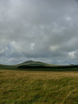
All Topics  
Bodmin Moor

 
Bodmin Moor

   Email Print
   Bookmark   Link


Bodmin Moor


Bodmin Moor is a granite
Granite

Granite is a common and widely occurring type of Intrusion , felsic, igneous rock rock . Granite has a medium to coarse texture, occasionally with some individual crystals larger than the groundmass forming a rock known as Porphyry ....
 moorland
Moorland

File:Pennine scenery.jpgMoorland or moor is a type of Habitat found in upland areas, characterised by low growing vegetation on acidic soils....
 in northeastern Cornwall
Cornwall

Cornwall , constitutional Duchy and palatine, is a metropolitan and non-metropolitan counties of England of England, United Kingdom, located at the tip of the south-western peninsula of Great Britain....
, UK
United Kingdom

The United Kingdom of Great Britain and Northern Ireland, commonly known as the United Kingdom , the UK or Britain,is a sovereign state located off the northwestern coast of continental Europe....
, 208 kmē (80 sq mile) in size, dating from the Carboniferous
Carboniferous

The Carboniferous is a geologic period that extends from the end of the Devonian period, about 359.2 ? 2.5 annum , to the beginning of the Permian period, about 299.0 ? 0.8 Ma ...
 period of geological
Geology

Geology is the science and study of the solid and liquid matter that constitute the Earth. The field of geology encompasses the study of the composition, structural geology, physical properties, dynamics, and History of the Earth of Earth materials, and the processes by which they are formed, moved, and changed....
 history.

The name "Bodmin Moor" is relatively recent, being an Ordnance Survey
Ordnance Survey

Ordnance Survey is an executive agency of the United Kingdom government. It is the national mapping agency for Great Britain, and one of the world's largest producers of maps....
 invention of 1813. It was formerly known as "Fowey Moor", after the river
River Fowey

The River Fowey is a river in Cornwall, England, United Kingdom.It source about 1 mile north-west of Brown Willy on Bodmin Moor, passes Lanhydrock House, Restormel Castle and Lostwithiel, then broadens at Milltown, Cornwall before joining the English Channel at Fowey....
 which rises here.

atic granite tors
Tor (geography)

A tor is a rock outcrop formed by weathering, usually found on or near the summit of a hill. In the South West England, where the term originated, it is also a word used for the hills themselves ? particularly the high points of Dartmoor in Devon and Bodmin Moor in Cornwall....
 rise from the rolling moorland: the best known are Brown Willy
Brown Willy

Brown Willy is a hill in Cornwall, United Kingdom. The summit is the highest point of Bodmin Moor and of Cornwall as a whole.The name is sometimes suggested to come from bron ughella meaning "highest hill", as it is the highest point in Cornwall, but Weatherhill disagrees....
 (the highest point in Cornwall at 417 m: 1368 ft) and Rough Tor
Rough Tor

Rough Tor, or Roughtor, pronounced Rowter , is a hill and tor on Bodmin Moor, Cornwall. Its summit is 1313 ft above mean sea level, making it one of the highest points in Cornwall....
 at 400 m (1313 ft).


Discussion
Ask a question about 'Bodmin Moor'
Start a new discussion about 'Bodmin Moor'
Answer questions from other users
Full Discussion Forum


Encyclopedia


the Cheesewring
Bodmin Moor is a granite
Granite

Granite is a common and widely occurring type of Intrusion , felsic, igneous rock rock . Granite has a medium to coarse texture, occasionally with some individual crystals larger than the groundmass forming a rock known as Porphyry ....
 moorland
Moorland

File:Pennine scenery.jpgMoorland or moor is a type of Habitat found in upland areas, characterised by low growing vegetation on acidic soils....
 in northeastern Cornwall
Cornwall

Cornwall , constitutional Duchy and palatine, is a metropolitan and non-metropolitan counties of England of England, United Kingdom, located at the tip of the south-western peninsula of Great Britain....
, UK
United Kingdom

The United Kingdom of Great Britain and Northern Ireland, commonly known as the United Kingdom , the UK or Britain,is a sovereign state located off the northwestern coast of continental Europe....
, 208 kmē (80 sq mile) in size, dating from the Carboniferous
Carboniferous

The Carboniferous is a geologic period that extends from the end of the Devonian period, about 359.2 ? 2.5 annum , to the beginning of the Permian period, about 299.0 ? 0.8 Ma ...
 period of geological
Geology

Geology is the science and study of the solid and liquid matter that constitute the Earth. The field of geology encompasses the study of the composition, structural geology, physical properties, dynamics, and History of the Earth of Earth materials, and the processes by which they are formed, moved, and changed....
 history.

The name "Bodmin Moor" is relatively recent, being an Ordnance Survey
Ordnance Survey

Ordnance Survey is an executive agency of the United Kingdom government. It is the national mapping agency for Great Britain, and one of the world's largest producers of maps....
 invention of 1813. It was formerly known as "Fowey Moor", after the river
River Fowey

The River Fowey is a river in Cornwall, England, United Kingdom.It source about 1 mile north-west of Brown Willy on Bodmin Moor, passes Lanhydrock House, Restormel Castle and Lostwithiel, then broadens at Milltown, Cornwall before joining the English Channel at Fowey....
 which rises here.

Landscape features

Dramatic granite tors
Tor (geography)

A tor is a rock outcrop formed by weathering, usually found on or near the summit of a hill. In the South West England, where the term originated, it is also a word used for the hills themselves ? particularly the high points of Dartmoor in Devon and Bodmin Moor in Cornwall....
 rise from the rolling moorland: the best known are Brown Willy
Brown Willy

Brown Willy is a hill in Cornwall, United Kingdom. The summit is the highest point of Bodmin Moor and of Cornwall as a whole.The name is sometimes suggested to come from bron ughella meaning "highest hill", as it is the highest point in Cornwall, but Weatherhill disagrees....
 (the highest point in Cornwall at 417 m: 1368 ft) and Rough Tor
Rough Tor

Rough Tor, or Roughtor, pronounced Rowter , is a hill and tor on Bodmin Moor, Cornwall. Its summit is 1313 ft above mean sea level, making it one of the highest points in Cornwall....
 at 400 m (1313 ft). To the south-east Kilmar Tor and Caradon Hill
Caradon Hill

Caradon Hill is on Bodmin Moor in the Caradon district of Cornwall, England, United Kingdom.The hill was once famous for its copper Minings but these are now closed....
 are the most prominent hills. Considerable areas of the moor are poorly drained and form marshes (in hot summers these can dry out). The rest of the moor is mostly rough pasture or overgrown with heather and other low vegetation.

The Moor contains about 500 holdings with around 10,000 beef cows, 55,000 breeding ewes and 1,000 horses and ponies. Most of the moor is a Site of Special Scientific Interest
Site of Special Scientific Interest

A Site of Special Scientific Interest or SSSI is a conservation designation denoting a protected area in the United Kingdom. SSSIs are the basic building block of site-based nature conservation legislation and most other legal nature/geological conservation designations in Great Britain are based upon them, including National Nature Res...
 (SSSI) and has been officially designated an Area of Outstanding Natural Beauty
Area of Outstanding Natural Beauty

An Area of Outstanding Natural Beauty is an area of Rural considered to have significant landscape value in England, Wales or Northern Ireland, that has been specially designated by the Countryside Agency on behalf of the United Kingdom government; the Countryside Council for Wales on behalf of the Welsh Assembly Government; or the Norther...
 (AONB), as part of Cornwall AONB.

On the southern slopes of the moor lies Dozmary Pool
Dozmary Pool

Dozmary Pool is a small lake on Bodmin Moor, Cornwall, UK. It lies about 15 km northeast of Bodmin and 2 km south of Bolventor: it originated in the post-glacial period....
. It is Cornwall's only natural inland lake and is glacial in origin. In the 20th century three reservoirs have been constructed on the moor (see Rivers, below).

Parishes

]] The parishes on the moor are as follows
  • Advent
    Advent, Cornwall

    File:Advent Church-by-Chris-Heaton.jpgAdvent is a civil parish on the north-western edge of Bodmin Moor in north Cornwall, United Kingdom. It is named for St Adwenna and lies in the Registration District of Camelford....
  • Altarnun
    Altarnun

    Altarnun , is a village and civil parish in the North Cornwall district of Cornwall, United Kingdom. The village is on the north-eastern edge of Bodmin Moor....
  • Blisland
    Blisland

    Blisland is a village and civil parish in the North Cornwall district of Cornwall, England, United Kingdom, about seven miles north of Bodmin....
  • Bolventor
    Bolventor

    Bolventor is a hamlet on Bodmin Moor in Cornwall, United Kingdom. The village is bypassed by a dual carriageway section of the A30 road between Launceston, Cornwall and Bodmin, Cornwall....
  • Camelford
    Camelford

    Camelford is a town in Cornwall, England, United Kingdom.The town lies on the River Camel, and a few miles north-west of the highest part of Bodmin Moor....
  • Davidstow
    Davidstow

    Davidstow is a village and civil parish in Cornwall, in the United Kingdom.The village is located along the A395 road, about 3 miles north of Camelford and 15 miles west of Launceston, Cornwall....
  • Lewannick
    Lewannick

    Lewannick is a village near the town of Launceston, Cornwall in Cornwall, England, UK.Evidence of early medieval habitation at Lewannick is in the form of two inscribed pillar stones, each having text in both Latin and ogham characters; on the basis of the ogham text, these stones have been dated as having been inscribed between the fifth...
  • Linkinhorne
    Linkinhorne

    Linkinhorne is a rural parish in South East Cornwall, bordered by the River Inny in the north-east and Bodmin Moor to the west. It is largely rural but the area west of the B3254 road from Launceston, Cornwall to Liskeard forms part of Bodmin Moor and this includes Caradon Hill and an area of disused mines....
  • North Hill
    North Hill, Cornwall

    North Hill is a village in the North Cornwall district of Cornwall, United Kingdom....
  • St Breward
    St Breward

    St Breward is a village and civil parish in the North Cornwall District of Cornwall, England, United Kingdom. It is located on the western side of Bodmin Moor....
  • St Cleer
    St Cleer

    St Cleer is a village and parish in Cornwall, United Kingdom, situated to the north of Liskeard. It is in the south-east of Bodmin Moor, and in the local government non-metropolitan district of Caradon....
  • St Clether
    St Clether

    St Clether is small village and civil parish on Bodmin Moor in Cornwall, UK.St Clether is small village beside the River Inney with the parish church standing some distance away....
  • St Ive
    St Ive

    File:St Ive Cornwall Parish Church E 2006 03 27.jpgSt Ive is a village and civil parish in Caradon District, south-east Cornwall, United Kingdom....
  • St Neot
  • Warleggan
    Warleggan

    Warleggan is a civil parish on the southern edge of Bodmin Moor in Cornwall, United Kingdom . The nearest villages are Cardinham and St Neot, Cornwall: the parish is roughly oblong in shape with hamlets near the church and at Mount....


Rivers

The moor is the source of a number of the county's main rivers: they are mentioned here anti-clockwise from the south. The River Fowey
River Fowey

The River Fowey is a river in Cornwall, England, United Kingdom.It source about 1 mile north-west of Brown Willy on Bodmin Moor, passes Lanhydrock House, Restormel Castle and Lostwithiel, then broadens at Milltown, Cornwall before joining the English Channel at Fowey....
 rises at a height of 290 m and flows through Lostwithiel
Lostwithiel

Lostwithiel is a civil parish and small town in Cornwall, England, United Kingdom at the head of the estuary of the River Fowey. According to the 2001 census it had a population of 2,739....
 and into the Fowey
Fowey

Fowey is a small town, civil parish and cargo port at the mouth of the River Fowey in south Cornwall, England, UK. According to the 2001 census it had a population of 2,273....
 estuary.

The River Tiddy
River Tiddy

The River Tiddy is a small river in south-east Cornwall, the main tributary of the River Lynher. The Tiddy rises near Pensilva and flows south east past the village of Tideford until it joins the Lynher....
 rises near Pensilva and flows south east until it joins the river Lynher. The Lynher is one of the tributary streams of the Tamar: it flows generally south-east until it joins the Hamoaze
Hamoaze

The Hamoaze is an estuary stretch of water at the point where the tidal River Tamar, the River Tavy, and the River Lynher meet, prior to entering Plymouth Sound....
 near Plymouth. The River Inny
River Inny

The River Inny is a river in Ireland. It flows from Lough Sheelin in County Cavan and heads south to Lough Derravaragh. From there is flows westwards to the River Shannon, which it joins at Lough Ree....
 also flows into the Tamar.

The River Camel
River Camel

The River Camel is a river in Cornwall, UK. It source on the edge of Bodmin Moor and together with its tributaries drains a considerable part of North Cornwall....
 rises on Hendraburnick Down and flows for approximately 40 km (25 miles) before joining the sea at Padstow
Padstow

Padstow is a small town, civil parish and cargo port on the north coast of Cornwall, England, United Kingdom. It lies within the administrative district of North Cornwall....
. The River Camel and its tributary the De Lank River are an important habitat for the otter and both have been proposed as Special Areas of Conservation (SAC)

The De Lank River rises near Roughtor and flows along an irregular course before joining the Camel south of Wenford. The River Warleggan rises near Temple
Temple

A temple is a structure reserved for religious or spiritual activities, such as prayer and sacrifice, or analogous rites. A ??templum?? constituted a sacred precinct as defined by a priest, or augur....
 and flows south to join the Fowey.

Colliford Lake, Siblyback Lake and Crowdy reservoir
Crowdy Reservoir

Crowdy Reservoir is located on Bodmin Moor near Camelford in North Cornwall. It supplies water to the North Cornwall water distribution network via treatment at the Lowermoor Water Treatment Works....
s supply water for a large part of the county's population. Various species of waterfowl are resident around these waters.

History and antiquities


Prehistoric times

10,000 years ago Mesolithic
Mesolithic

The Mesolithic or Middle Stone Age was a period in the development of human technology in between the Paleolithic or Old Stone Age and the Neolithic or New Stone Age....
 hunter-gatherers wandered the moor when it was wooded and had a temperate climate. During the Neolithic
Neolithic

The Neolithic period was a period in the development of human technology, beginning about 9500 Before the Christian Era in the Middle East that is traditionally considered the last part of the Stone Age....
 era, from about 4,500 to 2,300 BC, people began clearing trees and farming the land. More than 200 Bronze Age
Bronze Age

The Bronze Age is, with respect to a given prehistory, the period in that society when the most advanced metalworking included smelting copper and tin from naturally-occurring outcroppings of copper and tin ores, creating a bronze alloy by melting those metals together, and casting them into bronze artifact s....
 settlements with enclosures
Enclosure (archaeology)

In archaeology, an enclosure is one of the most common types of archaeological site. It is any area of land separated from surrounding land by earthworks, walls or fencing....
 and field patterns have been recorded.and many prehistoric stone barrows
Tumulus

A tumulus is a mound of Soil and Rock s raised over a Grave or graves. Tumuli are also known as barrows, burial mounds, H?gelgrab or kurgans, and can be found throughout much of the world....
 and circles
Stone circle

A stone circle is an ancient monument. Such a monument is not always precisely circular and often forms an ellipse, or a setting of four stones laid on an arc of a circle....
 lie scattered across the moor.

King Arthur's Hall
King Arthur's Hall

King Arthur's Hall thought to be a late Neolithic or early Bronze Age ceremonial site on Bodmin Moor Cornwall, England, United Kingdom. It should not be confused with the hall in Tintagel built as the headquarters of the Fellowship of the Round Table....
 thought to be a late Neolithic
Neolithic

The Neolithic period was a period in the development of human technology, beginning about 9500 Before the Christian Era in the Middle East that is traditionally considered the last part of the Stone Age....
 or early Bronze Age
Bronze Age

The Bronze Age is, with respect to a given prehistory, the period in that society when the most advanced metalworking included smelting copper and tin from naturally-occurring outcroppings of copper and tin ores, creating a bronze alloy by melting those metals together, and casting them into bronze artifact s....
 ceremonial site can be found to the east of St Breward
St Breward

St Breward is a village and civil parish in the North Cornwall District of Cornwall, England, United Kingdom. It is located on the western side of Bodmin Moor....
 on the moor.

Medieval and modern times

Where practicable areas of the moor were used for pasture by herdsmen from the parishes surrounding the moor. Granite boulders were also taken from the moor and used for stone posts and to a certain extent for building (such material is known as moorstone). Granite quarrying only became reasonably productive when gunpowder became available.

Until the establishment of a turnpike road through the moor (the present A30
A30 road

The A30 is an old trunk road which runs from central London to Land's End, the westernmost point of the mainland of southern Great Britain , and is sometimes called the Great South West Road....
) in the 1770s the size of the moorland area made travel within Cornwall very difficult.

Legends and traditions

Dozmary Pool is identified by some people with the lake in which, according to Arthurian
King Arthur

King Arthur is a legendary Britons leader who, according to medieval histories and Romance , led the defence of Britain against the Saxon invaders in the early 6th century....
 legend, Sir Bedivere
Sir Bedivere

Sir Bedivere may refer to more than one thing:*For the Knight of the Round Table, see Bedivere*For the ship of that name, see RFA Sir Bedivere ...
 threw Excalibur
Excalibur

Excalibur is the legendary sword of King Arthur sometimes attributed with magical powers or associated with the rightful sovereignty of Great Britain....
 to The Lady of the Lake. Another legend relating to the pool concerns Jan Tregeagle.

The Beast of Bodmin
Beast of Bodmin

The Beast of Bodmin, like The Beast of Exmoor, is a Phantom cat which ranges in Cornwall in the United Kingdom. Bodmin Moor became a centre of these sightings with occasional reports of mutilated slain livestock: the alleged Leopard-like cats of the same region came to be popularly known as the Beast of Bodmin Moor....
 has been reported many times but never identified with certainty.

Monuments and ruins

Roughtor was the site of a medieval chapel of St Michael and is now designated as a memorial to the 43rd Wessex Division of the British Army. In 1844 on Bodmin Moor the body of 18 year old Charlotte Dymond was discovered. Local labourer Matthew Weeks was accused of the murder and at noon on 12 August 1844 he was led from Bodmin Gaol
Bodmin Gaol

Bodmin Gaol is a tourist attraction and former prison situated in Bodmin, on the edge of Bodmin Moor in Cornwall. Now partially in ruins, the building displays small exhibits of infamous villains taken captive in Bodmin and offers a grim view into the criminal culture of Cornwall in days gone by....
 and hanged. The murder site now has a monument erected from public money and the grave is at Davidstow
Davidstow

Davidstow is a village and civil parish in Cornwall, in the United Kingdom.The village is located along the A395 road, about 3 miles north of Camelford and 15 miles west of Launceston, Cornwall....
 churchyard.

See also

  • Beast of Bodmin
    Beast of Bodmin

    The Beast of Bodmin, like The Beast of Exmoor, is a Phantom cat which ranges in Cornwall in the United Kingdom. Bodmin Moor became a centre of these sightings with occasional reports of mutilated slain livestock: the alleged Leopard-like cats of the same region came to be popularly known as the Beast of Bodmin Moor....
  • Geology of the United Kingdom
  • List of topics related to Cornwall
    List of topics related to Cornwall

    This is a list of topics related to Cornwall, United Kingdom. The :Category:Cornwall contains a more comprehensive selection of Cornish articles....
  • Brown Willy effect
    Brown Willy effect

    The brown willy effect is a meteorology phenomenon that sometimes occurs across the south-west peninsula of England. It leads to heavy precipitation developing over the high ground of Bodmin Moor in Cornwall, which then often travel a considerable distance downwind of their place of origin....


External links