
Exmoor
Encyclopedia
Exmoor is an area of hilly open moorland
in west Somerset
and north Devon
in South West England
, named after the main river that flows out of the district, the River Exe
. The moor has given its name to a National Park
, which includes the Brendon Hills
, the East Lyn Valley
, the Vale of Porlock and 55 kilometres (34 mi) of the Bristol Channel
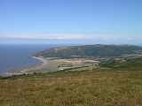
coast. The total area of the park is 692.8 square kilometre, of which 71% is in Somerset and 29% in Devon. The National Park is primarily an upland area with a dispersed population living mainly in small villages and hamlets. The largest settlements are Porlock
, Dulverton
, Lynton
, and Lynmouth
, which together contain almost 40% of the park's population. Lynton and Lynmouth are combined into one parish and are connected by the Lynton and Lynmouth Cliff Railway
.
Exmoor was once a Royal forest
and hunting ground, which was sold off in 1818. Exmoor was designated a National Park in 1954, under the 1949 National Parks and Access to the Countryside Act
. Several areas of the moor have been declared Sites of Special Scientific Interest
due to the flora and fauna. This title earns the site some legal protection from development, damage and neglect. In 1993 Exmoor was also designated an Environmentally Sensitive Area
.
rocks classified as gritstone
s, sandstone
s, slate
, shale
and limestone
, siltstone
s, and mudstone
s depending on the particle size. They are largely from the Devonian
and early Carboniferous
periods (the name Devonian comes from Devon, as rocks of that age were first studied and described here). As this area of Britain was not subject to glaciation
, the plateau remains as a remarkably old landform. Quartz
and iron
mineralisation can be detected in outcrops and subsoil. The Glenthorne
area demonstrates the Trentishoe Formation of the Hangman Sandstone Group. The Hangman Sandstone represents the Middle Devonian
sequence of North Devon and Somerset. These unusual freshwater deposits in the Hangman Grits, were mainly formed in desert conditions. The underlying rocks are covered by moors and supported by wet, acid soil. The highest point on Exmoor is Dunkery Beacon
; at 519 metres (1,703 ft) it is also the highest point in Somerset.
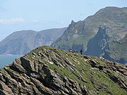 Exmoor has 55 kilometres (34 mi) of coastline, including the highest sea cliffs in England, which reach a height of 314 metres (1,030 ft) at Culbone
Hill. However, the crest of this coastal ridge of hills is more than 1.6 km (0.994196378639691 mi) from the sea. If a cliff is defined as having a slope greater than 60 degrees, the highest sea cliff on mainland Britain is Great Hangman
near Combe Martin
at 318 metres (1,043 ft) high, with a cliff face of 250 metres (820 ft). Its sister cliff is the 250 metres (820 ft) Little Hangman, which marks the edge of Exmoor.
Exmoor's woodlands sometimes reach the shoreline, especially between Porlock
and The Foreland, where they form the single longest stretch of coastal woodland in England and Wales
. The Exmoor Coastal Heaths
have been recognised as a Site of Special Scientific Interest
due to the diversity of plant species present.
The scenery of rocky headlands, ravines, waterfalls and towering cliffs gained the Exmoor coast recognition as a Heritage Coast in 1991. With its huge waterfalls and caves, this dramatic coastline has become an adventure playground for both climbers and explorers. The cliffs provide one of the longest and most isolated seacliff traverses in the UK. The South West Coast Path
, at 1014 kilometres (630 mi) the longest National Trail
in England and Wales, starts at Minehead
and runs along all of Exmoor's coast. There are small harbours at Lynmouth
, Porlock Weir
and Combe Martin
. Once crucial to coastal trade, the harbours are now primarily used for pleasure; individually owned sail boats and non-commercial fishing boats are often found in the harbours.
The Valley of the Rocks
beyond Lynton
is a deep dry valley that runs parallel to the nearby sea and is capped on the seaward side by large rocks.
 The high ground forms the catchment area
for numerous rivers and streams. There are about 483 kilometres (300.1 mi) of named rivers on Exmoor. The River Exe
, for which Exmoor is named, rises at Exe Head near the village of Simonsbath
, close to the Bristol Channel
coast, but flows more or less directly due south, so that most of its length lies in Devon
. It reaches the sea at a substantial ria
(estuary
) on the south (English Channel
) coast of Devon. Historically, its lowest bridging point was at Exeter
, though there is now a viaduct for the M5 motorway
about 3 kilometres (1.9 mi) south of the city centre. It has several tributaries which arise on Exmoor. The River Barle
runs from northern Exmoor to join the River Exe at Exebridge
, Devon
. The river and the Barle Valley
are both designated as biological Site of Special Scientific Interest
. Another tributary, the River Haddeo
, flows from the Wimbleball Lake
.
Most other rivers arising on Exmoor flow north to the Bristol Channel
. These include the River Heddon
which runs along the western edges of Exmoor, reaching the North Devon coast at Heddon's Mouth
, and the East
and West Lyn
which meet at Lynmouth
. Hoar Oak Water
is a moorland tributary of the East Lyn River
the confluence being at Watersmeet. The River Horner
, which is also known as Horner Water, rises near Luccombe
and flows into Porlock Bay
near Hurlstone Point. The main exception to northward-draining rivers is the River Mole
which arises on the south-western flanks of Exmoor. It is the major tributary of the River Taw
which itself flows northward from Dartmoor
.
Badgworthy Water
is one of the small rivers running north to the coast, and is associated with the Lorna Doone
legends.
 Along with the rest of South West England
, Exmoor has a temperate climate which is generally wetter and milder than the rest of England. The mean annual temperature at Simonsbath
is 8.3 °C (46.9 °F) with a season
al and diurnal
variation, but due to the modifying effect of the sea the range is less than in most other parts of the UK. January is the coldest month, with mean minimum temperatures between 1 and 2 °C (33.8 and 35.6 F). July and August are the warmest months in the region, with mean daily maxima around 21 °C (69.8 °F). In general, December is the month with the least sunshine and June the month with the most sun. The south west of England has a favoured location with regard to the Azores
high pressure when it extends its influence north-eastwards towards the UK, particularly in summer.
Cloud
often forms inland, especially near hills, and reduce the amount of sunshine that reaches the park. The average annual sunshine is about 1,600 hours. Rainfall
tends to be associated with Atlantic
depressions or with convection. In summer, convection, caused by the sun heating the land surface more than the sea, sometimes forms rain cloud
s and at that time of year a large proportion of the rainfall comes from showers and thunderstorm
s. Annual precipitation varies from 800 mm (31.5 in) in the east of the park to over 2000 mm (78.7 in) at The Chains. However in the 24-hours of 16 August 1952, more than 225 mm (8.9 in) of rain fell at The Chains. This rainfall, which followed an exceptionally wet summer led to disastrous flooding in Lynmouth
with 34 dead and extensive damage to the small town.
Snow
fall is very variable from year to year and ranges from 23 days on the high moors to about 6 on coastal areas. November to March have the highest mean wind speeds, with June to August having the lightest winds. The wind comes mostly from the south west.
There are two Met Office Weather stations recording climate data within Exmoor; Liscombe and Nettlecombe.
 There is evidence of occupation of the area by people from Mesolithic
times onward. In the Neolithic period, people started to manage animals and grow crops on farms cleared from the woodland, rather than act purely as hunters and as gatherers. It is also likely that extraction and smelting of mineral ores to make metal tools, weapons, containers and ornaments started in the late Neolithic, and continued into the bronze
and Iron Age
s. An earthen ring at Parracombe
is believed to be a Neolithic henge
dating from 5000–4000 BC
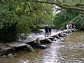
, and "Cow Castle", which is where White Water meets the River Barle, is an Iron Age fort at the top of a conical hill. Tarr Steps
are a prehistoric
(circa 1000 BC) clapper bridge
across the River Barle
, about 4 km (2.5 mi) south east of Withypool
and 6 km (3.7 mi) north west of Dulverton
. The stone slabs weigh up to 5 tonnes apiece and the bridge has been designated by English Heritage
as a grade I listed building, to recognise its special architectural, historical or cultural significance. There is little evidence of Roman occupation apart from two fortlets on the coast.
Holwell Castle, at Parracombe
, was a Norman
motte and bailey
castle built to guard the junction of the east–west and north–south trade routes, enabling movement of people and goods and the growth of the population. Alternative explanations for its construction suggest it may have been constructed to obtain taxes at the River Heddon
bridging place, or to protect and supervise silver
mining in the area around Combe Martin
. It was 40 metres (131 ft) in diameter and 6.2 metres (20 ft) high above the bottom of a rock cut ditch which is 2.7 metres (9 ft) deep. It was built, in the late 11th or early 12th century of earth with timber palisade
s for defence and a one or two storey wooden dwelling. It was probably built by either Martin de Tours, the first lord of Parracombe, William de Falaise (who married Martin's widow) or Robert fitz Martin
, although there are no written records to validate this. The earthworks of the castle are still clearly visible from a nearby footpath, but there is no public access to them. According to the late 13th-century Hundred Rolls
, King Henry II of England
(d. 1189) gave William of Wrotham
the office of steward of Exmoor. The parish of Exmoor Forest was part of the Hundred of Williton and Freemanners
.
 During the Middle Ages
, sheep farming for the wool trade came to dominate the economy. The wool was spun into thread on isolated farms and collected by merchants to be woven, fulled, dyed and finished in thriving towns such as Dunster
. The land started to be enclosed and from the 17th century onwards larger estates developed, leading to establishment of areas of large regular shaped fields. During the 16th and 17th centuries the commons were overstocked with agisted
livestock, from farmers outside the immediate area who were charged for the privilege. This led to disputes about the number of animals allowed and the enclosure of land. During this period a royal forest
and hunting ground was established, administered by a warden, so that king Charles I
could benefit from the fines and rents.
In the mid-17th century John Boevey was the warden. The house
that he built at Simonsbath
was the only one in the forest for 150 years. When the royal forest was sold off in 1818, John Knight bought the Simonsbath House and the accompanying farm for £50,000. He set about converting the royal forest into agricultural land. He and his family also built most of the large farms in the central section of the moor as well as 35.4 km (22 mi) of metalled access roads to Simonsbath and a 46.7 km (29 mi) wall around his estate, much of which still survives.
In the mid-19th century a mine was developed alongside the River Barle. The mine was originally called Wheal Maria, then changed to Wheal Eliza. It was a copper
mine from 1845–54 and then an iron
mine until 1857, although the first mining activity on the site may be from 1552. At Simonsbath, a restored Victorian
water-powered sawmill, which was damaged in the floods of 1992, has now been purchased by the National Park and returned to working order; it is now used to make the footpath signs, gates, stiles and bridges for various sites in the park.
Site of Special Scientific Interest
(SSSI), two other areas are specifically designated. North Exmoor covers 12005.3 hectares (29,665.7 acre) and includes the Dunkery Beacon
and the Holnicote
and Horner Water
Nature Conservation Review
sites, and the Chains
Geological Conservation Review
site. The Chains site is nationally important for its south-western lowland heath communities
and for transitions from Ancient woodland
through upland heath
to blanket mire
. The site is also of importance for its breeding bird communities, its large population of the nationally rare Heath Fritillary
butterfly
(Mellicta athalia), an exceptional woodland lichen
flora
and its palynological
interest of deep peat on the Chains.
The South Exmoor SSSI is smaller, covering 3132.7 hectares (7,741.1 acre) and including the River Barle
and its tributaries with submerged plants such as Alternate Water-milfoil
(Myriophyllum alterniflorum). There are small areas of semi-natural woodland within the site, including some which are ancient
. The most abundant tree species is Sessile Oak (Quercus petraea), the shrub layer is very sparse and the ground flora includes Bracken
, Bilberry
and a variety of mosses. The heaths have strong breeding populations of birds, including Whinchat
(Saxicola rubetra) and Stonechat (Saxicola torquata). Wheatear
(Oenanthe oenanthe) are common near stone boundary walls and other stony places. Grasshopper Warbler
(Locustella naevia) breed in scrub and tall heath. Trees on the moorland edges provide nesting sites for Redpoll
(Acanthis flammea), Common Buzzard
(Buteo buteo) and Raven
(Corvus corax).
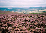 Uncultivated heath
and moorland cover about a quarter of Exmoor landscape. Some moors are covered by a variety of grass
es and sedges
, while others are dominated by heather
. There are also cultivated areas including the Brendon Hills
, which lie in the east of the National Park. There are also 8454 hectares (20,890 acre) of woodland, comprising a mixture of broad-leaved (oak
, ash and hazel
) and conifer
trees. Horner Woodlands and Tarr Steps
woodlands are prime examples. The country's highest beech tree, 350 metres (1,148 ft) above sea level, is at Birch Cleave at Simonsbath
but beech in hedgebanks grow up to 490 metres (1,608 ft). At least two species of whitebeam
tree: Sorbus subcuneata
and Sorbus 'Taxon D' are unique to Exmoor. These woodlands are home to lichen
s, moss
es and fern
s. Exmoor is the only national location for the lichens Biatoridium delitescens, Rinodina fimbriata and Rinodina flavosoralifera, the latter having been found only on one individual tree.
 Sheep have grazed on the moors for more than 3,000 years, shaping much of the Exmoor landscape by feeding on moorland grasses and heather. Traditional breeds include Exmoor Horn, Cheviot
and Whiteface Dartmoor
and Greyface Dartmoor
sheep. North Devon cattle
are also farmed in the area. Exmoor ponies
can be seen roaming freely on the moors. They are a landrace
rather than a breed
of pony, and may be the closest breed to Wild horse
s remaining in Europe. The ponies are rounded up once a year to be marked and checked over, they are also one of the oldest breeds in the world. In 1818 Sir Richard Acland
, the last warden of Exmoor, took thirty ponies and established the Acland Herd, now known as the Anchor Herd, whose direct descendants still roam the moor. In the Second World War
the moor became a training ground, and the breed was nearly killed off, with only 50 ponies surviving the war. The ponies are classified as endangered by the Rare Breeds Survival Trust
, with only 390 breeding females left in the UK. In 2006 a Rural Enterprise Grant, administered locally by the South West Rural Development Service, was obtained to create a new Exmoor Pony Centre at Ashwick, at a disused farm with 7 hectares (17.3 acre) of land with a further 56 hectares (138.4 acre) of moorland.
Red deer
have a stronghold on the moor and can be seen on quiet hillsides in remote areas, particularly in the early morning. The Emperor of Exmoor
, a red stag (Cervus elaphus), was Britain's largest known wild land animal, until it was killed in October 2010. The moorland
habitat is also home to hundreds of species of bird
s and insect
s. Birds seen on the moor include Merlin
, Peregrine Falcon
, Eurasian Curlew
, European Stonechat
, Dipper
, Dartford Warbler
and Ring Ouzel
. Black Grouse
and Red Grouse
are now extinct
on Exmoor, probably as a result of a reduction in habitat management, and for the former species, an increase in visitor pressure.
is a cryptozoological
cat
(see phantom cat
) that is reported to roam Exmoor. There have been numerous reports of eyewitness sightings, however the official Exmoor National Park website lists the beast under "Traditions, Folklore and Legends", and the BBC calls it "the famous-yet-elusive beast of Exmoor. Allegedly." Sightings were first reported in the 1970s, although it became notorious in 1983, when a South Molton
farmer claimed to have lost over 100 sheep in the space of three months, all of them apparently killed by violent throat injuries. Descriptions of its colouration range from black to tan or dark grey. It is possibly a cougar or black leopard
which was released after a law was passed in 1976 making it illegal for them to be kept in captivity outside zoos. In 2006, the British Big Cats Society reported that a skull found by a Devon farmer was that of a Puma; however, the Department for Environment, Food and Rural Affairs
(Defra) states, "Based on the evidence, Defra does not believe that there are big cats living in the wild in England."
. About three quarters of the park is privately owned, made up of numerous private estates. The largest landowners are the National Trust
, which owns over 10% of the land, and the National Park Authority, which owns about 7%. Other areas are owned by the Forestry Commission
, Crown Estate
and Water Companies. The largest private landowner is the Badgworthy Land Company, which represents hunting interests.
From 1954 on, local government was the responsibility of the district and county councils, which remain responsible for the social and economic well-being of the local community. Since 1997 the Exmoor National Park Authority, which is known as a ‘single purpose’ authority, has taken over some functions to meet its aims to "conserve and enhance the natural beauty, wildlife and cultural heritage of the National Parks" and "promote opportunities for the understanding and enjoyment of the special qualities of the parks by the public", including responsibility for the conservation of the historic environment.
The Park Authority receives 80% of its funding as a direct grant from the government. The Park Authority Committee consists of members from parish and county councils, and six appointed by the Secretary of State
. The work is carried out by rangers, volunteers and a team of 13 estate workers who carry out a wide range of tasks including maintaining the many miles of rights of way, hedge laying
, fencing, swaling, walling, invasive weed control and habitat management on National Park Authority land. There are ongoing debates between the authority and farmers over the biological monitoring of SSSIs, showing the need for a controlled regime of grazing and burning; farmers claim that these regimes are not practical or effective in the long term.
of animals, particularly deer, with dogs was abolished by the Hunting Act 2004
, the Exmoor hunts still meet in full regalia and there is a campaign to resurrect this rural sport. During the Spring, amateur steeplechase meetings (Point to Points) are run by hunts at temporary courses such as Bratton Down
and Holnicote
. These, along with thoroughbred racing and pony racing
, are an opportunity for farmers, huntstaff and the public to witness a day of traditional country entertainment.
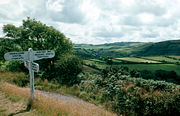
For others walking
, climbing
and the scenery are the attractions. The Coleridge Way
is a 58 km (36 mi) footpath
which follows the walks taken by poet Samuel Taylor Coleridge
to Porlock
, starting from Coleridge Cottage
at Nether Stowey
, where he once lived. It starts in the Quantocks
before moving onto the Brendon Hills
and crosses the fringes of Exmoor National Park at Dunkery Beacon
before finishing in Porlock
. The Two Moors Way
runs from Ivybridge
in South Devon
to Lynmouth
on the coast of North Devon, crossing parts of both Dartmoor
and Exmoor. Both of these walks intersect with the South West Coast Path
, Britain's longest National Trail
, which starts at Minehead and follows the Exmoor coast before continuing to Poole
.
 The attractions of Exmoor include 208 Scheduled monuments, 16 conservation areas, and other open access land as designated by the Countryside and Rights of Way Act 2000
. Exmoor receives approximately 1.4 million visitor days per year. Many come to walk on the moors or along waymarked paths such as the Coleridge Way. Attractions on the coast include the Lynton and Lynmouth Cliff Railway
, which connects Lynton
to neighbouring Lynmouth
, where the East
and West Lyn River
meet. Woody Bay, a few miles west of Lynton
, is home to the Lynton & Barnstaple Railway
, a narrow gauge railway which connected the twin towns of Lynton and Lynmouth to Barnstaple
, about 31 km (just over 19 miles) away. Further along the coast, Porlock is a quiet coastal town with an adjacent salt marsh
nature reserve and a harbour at nearby Porlock Weir
. Watchet
is a historic harbour town with a marina and is home to a carnival, which is held annually in July.
Inland, many of the attractions are centred around small towns and villages or linked to the river valleys, such as the ancient clapper bridge at Tarr Steps
and the Snowdrop Valley near Wheddon Cross, which is carpeted in snowdrops in February and, later, displays bluebells. Withypool
is also in the Barle Valley. The Two Moors Way
passes through the village. As well as Dunster Castle
, Dunster
's other attractions include a priory, dovecote
, yarn market, inn, packhorse bridge
, mill and a stop on the West Somerset Railway
. Exford
, lies on the River Exe.
Exmoor has been the setting for several novel
s including the 19th century Lorna Doone: A Romance of Exmoor
by R. D. Blackmore
, and Margaret Drabble's 1998 novel The Witch of Exmoor. The park was featured on the television programme Seven Natural Wonders
twice, as one of the wonders of the West Country
.
Moorland
Moorland or moor is a type of habitat, in the temperate grasslands, savannas, and shrublands biome, found in upland areas, characterised by low-growing vegetation on acidic soils and heavy fog...
in west Somerset
Somerset
The ceremonial and non-metropolitan county of Somerset in South West England borders Bristol and Gloucestershire to the north, Wiltshire to the east, Dorset to the south-east, and Devon to the south-west. It is partly bounded to the north and west by the Bristol Channel and the estuary of the...
and north Devon
Devon
Devon is a large county in southwestern England. The county is sometimes referred to as Devonshire, although the term is rarely used inside the county itself as the county has never been officially "shired", it often indicates a traditional or historical context.The county shares borders with...
in South West England
South West England
South West England is one of the regions of England defined by the Government of the United Kingdom for statistical and other purposes. It is the largest such region in area, covering and comprising Bristol, Gloucestershire, Somerset, Dorset, Wiltshire, Devon, Cornwall and the Isles of Scilly. ...
, named after the main river that flows out of the district, the River Exe
River Exe
The River Exe in England rises near the village of Simonsbath, on Exmoor in Somerset, near the Bristol Channel coast, but flows more or less directly due south, so that most of its length lies in Devon. It reaches the sea at a substantial ria, the Exe Estuary, on the south coast of Devon...
. The moor has given its name to a National Park
National parks of England and Wales
The national parks of England and Wales are areas of relatively undeveloped and scenic landscape that are designated under the National Parks and Access to the Countryside Act 1949...
, which includes the Brendon Hills
Brendon Hills
The Brendon Hills are composed of a lofty ridge of hills in the East Lyn Valley area of western Somerset, England. The terrain is broken by a series of deeply incised streams and rivers running roughly southwards to meet the River Haddeo, a tributary of the River Exe.The hills are quite heavily...
, the East Lyn Valley
East Lyn Valley
East Lyn Valley is a valley of Exmoor, covering northern Devon and western Somerset, England.The East Lyn River is formed from several main tributaries beginning near Weir Water...
, the Vale of Porlock and 55 kilometres (34 mi) of the Bristol Channel
Bristol Channel
The Bristol Channel is a major inlet in the island of Great Britain, separating South Wales from Devon and Somerset in South West England. It extends from the lower estuary of the River Severn to the North Atlantic Ocean...
coast. The total area of the park is 692.8 square kilometre, of which 71% is in Somerset and 29% in Devon. The National Park is primarily an upland area with a dispersed population living mainly in small villages and hamlets. The largest settlements are Porlock
Porlock
Porlock is a coastal village and civil parish in Somerset, England, situated in a deep hollow below Exmoor, west of Minehead. The parish, which includes Hawkcombe and Doverhay, has a population of 1,377....
, Dulverton
Dulverton
Dulverton is a town and civil parish in the heart of West Somerset, England, near the border with Devon. The town has a population of 1,630. The parish includes the hamlets of Battleton and Ashwick which is located approximately north west of Dulverton...
, Lynton
Lynton
Lynton is a small town in Devon, England. It lies on the northern edge of Exmoor and is located at the top of a gorge above Lynmouth, to which it is connected by the Lynton and Lynmouth Cliff Railway...
, and Lynmouth
Lynmouth
Lynmouth is a village in Devon, England, on the north edge of Exmoor.The village straddles the confluence of the West Lyn and East Lyn rivers, in a gorge below Lynton, to which it is connected by the Lynton and Lynmouth Cliff Railway....
, which together contain almost 40% of the park's population. Lynton and Lynmouth are combined into one parish and are connected by the Lynton and Lynmouth Cliff Railway
Lynton and Lynmouth Cliff Railway
The Lynton and Lynmouth Cliff Railway is a water-powered funicular railway joining the twin towns of Lynton and Lynmouth on the rugged coast of North Devon.-Origins:...
.
Exmoor was once a Royal forest
Royal forest
A royal forest is an area of land with different meanings in England, Wales and Scotland; the term forest does not mean forest as it is understood today, as an area of densely wooded land...
and hunting ground, which was sold off in 1818. Exmoor was designated a National Park in 1954, under the 1949 National Parks and Access to the Countryside Act
National Parks and Access to the Countryside Act 1949
The National Parks and Access to the Countryside Act 1949 is an Act of the Parliament of the United Kingdom which created the National Parks Commission which later became the Countryside Commission and then the Countryside Agency, which became Natural England when it merged with English Nature in...
. Several areas of the moor have been declared Sites of Special Scientific Interest
Site of Special Scientific Interest
A Site of Special Scientific Interest is a conservation designation denoting a protected area in the United Kingdom. SSSIs are the basic building block of site-based nature conservation legislation and most other legal nature/geological conservation designations in Great Britain are based upon...
due to the flora and fauna. This title earns the site some legal protection from development, damage and neglect. In 1993 Exmoor was also designated an Environmentally Sensitive Area
Environmentally Sensitive Area
An Environmentally Sensitive Area is a type of designation for an agricultural area which needs special protection because of its landscape, wildlife or historical value. The scheme was introduced in 1987...
.
Geology
Exmoor is an upland of sedimentarySedimentary rock
Sedimentary rock are types of rock that are formed by the deposition of material at the Earth's surface and within bodies of water. Sedimentation is the collective name for processes that cause mineral and/or organic particles to settle and accumulate or minerals to precipitate from a solution....
rocks classified as gritstone
Gritstone
Gritstone or Grit is a hard, coarse-grained, siliceous sandstone. This term is especially applied to such sandstones that are quarried for building material. British gritstone was used for millstones to mill flour, to grind wood into pulp for paper and for grindstones to sharpen blades. "Grit" is...
s, sandstone
Sandstone
Sandstone is a sedimentary rock composed mainly of sand-sized minerals or rock grains.Most sandstone is composed of quartz and/or feldspar because these are the most common minerals in the Earth's crust. Like sand, sandstone may be any colour, but the most common colours are tan, brown, yellow,...
s, slate
Slate
Slate is a fine-grained, foliated, homogeneous metamorphic rock derived from an original shale-type sedimentary rock composed of clay or volcanic ash through low-grade regional metamorphism. The result is a foliated rock in which the foliation may not correspond to the original sedimentary layering...
, shale
Shale
Shale is a fine-grained, clastic sedimentary rock composed of mud that is a mix of flakes of clay minerals and tiny fragments of other minerals, especially quartz and calcite. The ratio of clay to other minerals is variable. Shale is characterized by breaks along thin laminae or parallel layering...
and limestone
Limestone
Limestone is a sedimentary rock composed largely of the minerals calcite and aragonite, which are different crystal forms of calcium carbonate . Many limestones are composed from skeletal fragments of marine organisms such as coral or foraminifera....
, siltstone
Siltstone
Siltstone is a sedimentary rock which has a grain size in the silt range, finer than sandstone and coarser than claystones.- Description :As its name implies, it is primarily composed of silt sized particles, defined as grains 1/16 - 1/256 mm or 4 to 8 on the Krumbein phi scale...
s, and mudstone
Mudstone
Mudstone is a fine grained sedimentary rock whose original constituents were clays or muds. Grain size is up to 0.0625 mm with individual grains too small to be distinguished without a microscope. With increased pressure over time the platey clay minerals may become aligned, with the...
s depending on the particle size. They are largely from the Devonian
Devonian
The Devonian is a geologic period and system of the Paleozoic Era spanning from the end of the Silurian Period, about 416.0 ± 2.8 Mya , to the beginning of the Carboniferous Period, about 359.2 ± 2.5 Mya...
and early Carboniferous
Carboniferous
The Carboniferous is a geologic period and system that extends from the end of the Devonian Period, about 359.2 ± 2.5 Mya , to the beginning of the Permian Period, about 299.0 ± 0.8 Mya . The name is derived from the Latin word for coal, carbo. Carboniferous means "coal-bearing"...
periods (the name Devonian comes from Devon, as rocks of that age were first studied and described here). As this area of Britain was not subject to glaciation
Glacial period
A glacial period is an interval of time within an ice age that is marked by colder temperatures and glacier advances. Interglacials, on the other hand, are periods of warmer climate within an ice age...
, the plateau remains as a remarkably old landform. Quartz
Quartz
Quartz is the second-most-abundant mineral in the Earth's continental crust, after feldspar. It is made up of a continuous framework of SiO4 silicon–oxygen tetrahedra, with each oxygen being shared between two tetrahedra, giving an overall formula SiO2. There are many different varieties of quartz,...
and iron
Iron
Iron is a chemical element with the symbol Fe and atomic number 26. It is a metal in the first transition series. It is the most common element forming the planet Earth as a whole, forming much of Earth's outer and inner core. It is the fourth most common element in the Earth's crust...
mineralisation can be detected in outcrops and subsoil. The Glenthorne
Glenthorne
Glenthorne is a 13.3 hectare geological Site of Special Scientific Interest in the parish of Oare within the Exmoor National Park, on the border of Somerset and Devon, notified in 1989....
area demonstrates the Trentishoe Formation of the Hangman Sandstone Group. The Hangman Sandstone represents the Middle Devonian
Devonian
The Devonian is a geologic period and system of the Paleozoic Era spanning from the end of the Silurian Period, about 416.0 ± 2.8 Mya , to the beginning of the Carboniferous Period, about 359.2 ± 2.5 Mya...
sequence of North Devon and Somerset. These unusual freshwater deposits in the Hangman Grits, were mainly formed in desert conditions. The underlying rocks are covered by moors and supported by wet, acid soil. The highest point on Exmoor is Dunkery Beacon
Dunkery Beacon
Dunkery Beacon is the summit of Dunkery Hill, and the highest point on Exmoor and in Somerset, England. It is also the highest point in southern England outside Dartmoor....
; at 519 metres (1,703 ft) it is also the highest point in Somerset.
Coastline
Culbone
Culbone is a hamlet consisting of little more than the parish church and a few houses, in the parish of Oare in the Exmoor National Park, Somerset, England. As there is no road access it is a two-mile walk from Porlock Weir, and some four miles from Porlock itself.The village is situated in a...
Hill. However, the crest of this coastal ridge of hills is more than 1.6 km (0.994196378639691 mi) from the sea. If a cliff is defined as having a slope greater than 60 degrees, the highest sea cliff on mainland Britain is Great Hangman
Hangman cliffs
Hangman cliffs are near Combe Martin on Devon's Exmoor coast.Great Hangman is high with a cliff face of . It is the highest sea cliff in England and the highest point on the South West Coast Path....
near Combe Martin
Combe Martin
Combe Martin is a village and civil parish on the North Devon coast about east of Ilfracombe. It is a small seaside resort with a sheltered cove on the edge of the Exmoor National Park...
at 318 metres (1,043 ft) high, with a cliff face of 250 metres (820 ft). Its sister cliff is the 250 metres (820 ft) Little Hangman, which marks the edge of Exmoor.
Exmoor's woodlands sometimes reach the shoreline, especially between Porlock
Porlock
Porlock is a coastal village and civil parish in Somerset, England, situated in a deep hollow below Exmoor, west of Minehead. The parish, which includes Hawkcombe and Doverhay, has a population of 1,377....
and The Foreland, where they form the single longest stretch of coastal woodland in England and Wales
England and Wales
England and Wales is a jurisdiction within the United Kingdom. It consists of England and Wales, two of the four countries of the United Kingdom...
. The Exmoor Coastal Heaths
Exmoor Coastal Heaths
Exmoor Coastal Heaths is a 1758.3 hectare biological Site of Special Scientific Interest in Devon and Somerset, notified in 1994....
have been recognised as a Site of Special Scientific Interest
Site of Special Scientific Interest
A Site of Special Scientific Interest is a conservation designation denoting a protected area in the United Kingdom. SSSIs are the basic building block of site-based nature conservation legislation and most other legal nature/geological conservation designations in Great Britain are based upon...
due to the diversity of plant species present.
The scenery of rocky headlands, ravines, waterfalls and towering cliffs gained the Exmoor coast recognition as a Heritage Coast in 1991. With its huge waterfalls and caves, this dramatic coastline has become an adventure playground for both climbers and explorers. The cliffs provide one of the longest and most isolated seacliff traverses in the UK. The South West Coast Path
South West Coast Path
The South West Coast Path is Britain's longest waymarked long-distance footpath and a National Trail. It stretches for , running from Minehead in Somerset, along the coasts of Devon and Cornwall, to Poole Harbour in Dorset. Since it rises and falls with every river mouth, it is also one of the more...
, at 1014 kilometres (630 mi) the longest National Trail
National Trails
National Trails are long distance footpaths and bridleways in England and Wales. They are administered by Natural England and the Countryside Council for Wales, statutory agencies of the UK government....
in England and Wales, starts at Minehead
Minehead
Minehead is a coastal town and civil parish in Somerset, England. It lies on the south bank of the Bristol Channel, north-west of the county town of Taunton, from the border with the county of Devon and in proximity of the Exmoor National Park...
and runs along all of Exmoor's coast. There are small harbours at Lynmouth
Lynmouth
Lynmouth is a village in Devon, England, on the north edge of Exmoor.The village straddles the confluence of the West Lyn and East Lyn rivers, in a gorge below Lynton, to which it is connected by the Lynton and Lynmouth Cliff Railway....
, Porlock Weir
Porlock Weir
Porlock Weir lies about 1.5 miles west of Porlock, Somerset, England and is a small settlement which has grown up around the harbour. It is a popular visitor attraction....
and Combe Martin
Combe Martin
Combe Martin is a village and civil parish on the North Devon coast about east of Ilfracombe. It is a small seaside resort with a sheltered cove on the edge of the Exmoor National Park...
. Once crucial to coastal trade, the harbours are now primarily used for pleasure; individually owned sail boats and non-commercial fishing boats are often found in the harbours.
The Valley of the Rocks
Valley of the Rocks
The Valley of the Rocks or The Valley of Rocks is a dry valley that runs parallel to the coast in north Devon, England, about to the west of the village of Lynton...
beyond Lynton
Lynton
Lynton is a small town in Devon, England. It lies on the northern edge of Exmoor and is located at the top of a gorge above Lynmouth, to which it is connected by the Lynton and Lynmouth Cliff Railway...
is a deep dry valley that runs parallel to the nearby sea and is capped on the seaward side by large rocks.
Rivers
Drainage basin
A drainage basin is an extent or an area of land where surface water from rain and melting snow or ice converges to a single point, usually the exit of the basin, where the waters join another waterbody, such as a river, lake, reservoir, estuary, wetland, sea, or ocean...
for numerous rivers and streams. There are about 483 kilometres (300.1 mi) of named rivers on Exmoor. The River Exe
River Exe
The River Exe in England rises near the village of Simonsbath, on Exmoor in Somerset, near the Bristol Channel coast, but flows more or less directly due south, so that most of its length lies in Devon. It reaches the sea at a substantial ria, the Exe Estuary, on the south coast of Devon...
, for which Exmoor is named, rises at Exe Head near the village of Simonsbath
Simonsbath
Simonsbath is a village high on Exmoor in the English county of Somerset. It is the principal settlement in the Exmoor civil parish, which is the largest and most sparsely populated civil parish on Exmoor, covering nearly but with a population, at the time of the 2001 census, of 203 in 78...
, close to the Bristol Channel
Bristol Channel
The Bristol Channel is a major inlet in the island of Great Britain, separating South Wales from Devon and Somerset in South West England. It extends from the lower estuary of the River Severn to the North Atlantic Ocean...
coast, but flows more or less directly due south, so that most of its length lies in Devon
Devon
Devon is a large county in southwestern England. The county is sometimes referred to as Devonshire, although the term is rarely used inside the county itself as the county has never been officially "shired", it often indicates a traditional or historical context.The county shares borders with...
. It reaches the sea at a substantial ria
Ria
A ria is a coastal inlet formed by the partial submergence of an unglaciated river valley. It is a drowned river valley that remains open to the sea. Typically, rias have a dendritic, treelike outline although they can be straight and without significant branches. This pattern is inherited from the...
(estuary
Estuary
An estuary is a partly enclosed coastal body of water with one or more rivers or streams flowing into it, and with a free connection to the open sea....
) on the south (English Channel
English Channel
The English Channel , often referred to simply as the Channel, is an arm of the Atlantic Ocean that separates southern England from northern France, and joins the North Sea to the Atlantic. It is about long and varies in width from at its widest to in the Strait of Dover...
) coast of Devon. Historically, its lowest bridging point was at Exeter
Exeter
Exeter is a historic city in Devon, England. It lies within the ceremonial county of Devon, of which it is the county town as well as the home of Devon County Council. Currently the administrative area has the status of a non-metropolitan district, and is therefore under the administration of the...
, though there is now a viaduct for the M5 motorway
M5 motorway
The M5 is a motorway in England. It runs from a junction with the M6 at West Bromwich near Birmingham to Exeter in Devon. Heading south-west, the M5 runs east of West Bromwich and west of Birmingham through Sandwell Valley...
about 3 kilometres (1.9 mi) south of the city centre. It has several tributaries which arise on Exmoor. The River Barle
River Barle
The River Barle runs from the Chains on northern Exmoor, in Somerset, England to join the River Exe at Exebridge, Devon. The river and the Barle Valley are both designated as biological Site of Special Scientific Interest....
runs from northern Exmoor to join the River Exe at Exebridge
Exebridge
Exebridge is a village that lies on the border between Devon and Somerset, England. It lies at the confluence of the Barle and Exe rivers. Exebridge is named so because of the bridge over the River Exe that also marks the border between Devon and Somerset. It is located at ....
, Devon
Devon
Devon is a large county in southwestern England. The county is sometimes referred to as Devonshire, although the term is rarely used inside the county itself as the county has never been officially "shired", it often indicates a traditional or historical context.The county shares borders with...
. The river and the Barle Valley
Barle Valley
Barle Valley is a 104.2 hectare biological Site of Special Scientific Interest in Devon and Somerset, notified in 1997.The site includes the Somerset Wildlife Trust's Mounsey Wood Nature Reserve and Knaplock and North Barton SSSI notified in 1954...
are both designated as biological Site of Special Scientific Interest
Site of Special Scientific Interest
A Site of Special Scientific Interest is a conservation designation denoting a protected area in the United Kingdom. SSSIs are the basic building block of site-based nature conservation legislation and most other legal nature/geological conservation designations in Great Britain are based upon...
. Another tributary, the River Haddeo
River Haddeo
The River Haddeo on Exmoor in Somerset, England flows from the Wimbleball Lake to the River Exe.The valley of the river consists of three tributary valleys extending down from the surrounding farmland to merge with the River Haddeo in the south...
, flows from the Wimbleball Lake
Wimbleball Lake
Wimbleball Lake on Exmoor in Somerset, England, is a water supply reservoir constructed in the 1970s and completed in 1979.The high dam is of concrete buttress construction and impounds the River Haddeo to provide a water storage capacity of some 21,000 megalitres over an area of . Aggregate for...
.
Most other rivers arising on Exmoor flow north to the Bristol Channel
Bristol Channel
The Bristol Channel is a major inlet in the island of Great Britain, separating South Wales from Devon and Somerset in South West England. It extends from the lower estuary of the River Severn to the North Atlantic Ocean...
. These include the River Heddon
River Heddon
The River Heddon is a river in Devon, in the south of England. Running along the western edges of Exmoor, the river reaches the North Devon coast at Heddon's Mouth...
which runs along the western edges of Exmoor, reaching the North Devon coast at Heddon's Mouth
Heddon's Mouth
Heddon’s Mouth is a rocky cove on the coast of North Devon, England, about a mile down the River Heddon from the Hunter’s Inn. It is preserved for the nation by the National Trust....
, and the East
East Lyn River
The East Lyn is a river which rises high in Exmoor, Somerset. It flows through the East Lyn Valley.-Watercourse:The river starts as the Upper East Lyn at Malmsmead it then flows for several miles, past Brendon and makes confluence with Hoar Oak Water at Watersmeet, where Watersmeet House is...
and West Lyn
West Lyn River
The West Lyn is a river which rises high in Exmoor, Somerset, and joins the East Lyn at Lynmouth in Devon.The upper reaches have been designated as a Site of Special Scientific Interest, because of the geomorphological landforms created in the 1952 flood....
which meet at Lynmouth
Lynmouth
Lynmouth is a village in Devon, England, on the north edge of Exmoor.The village straddles the confluence of the West Lyn and East Lyn rivers, in a gorge below Lynton, to which it is connected by the Lynton and Lynmouth Cliff Railway....
. Hoar Oak Water
Hoar Oak Water
Hoar Oak Water is a moorland tributary of the East Lyn River in Exmoor, Somerset, England.It rises at Hoaroak Hill in the Chains geological site in and flows to Watersmeet House in Devon....
is a moorland tributary of the East Lyn River
East Lyn River
The East Lyn is a river which rises high in Exmoor, Somerset. It flows through the East Lyn Valley.-Watercourse:The river starts as the Upper East Lyn at Malmsmead it then flows for several miles, past Brendon and makes confluence with Hoar Oak Water at Watersmeet, where Watersmeet House is...
the confluence being at Watersmeet. The River Horner
River Horner
The River Horner also known as Horner Water rises near Luccombe on Exmoor, Somerset, and flows past Porlock into Porlock Bay near Hurlstone Point on the Bristol Channel....
, which is also known as Horner Water, rises near Luccombe
Luccombe
Luccombe is a village on the south coast of the Isle of Wight near Shanklin. There is some indication of Bronze Age settlements on the top of the nearby hill of Luccombe Down.The Luccombe area features some spectacular cliffs and scenery...
and flows into Porlock Bay
Porlock Bay
Porlock Bay is on the Bristol Channel, between Hurlstone Point and Porlock Weir in Somerset, England.The coastline includes shingle ridges, salt marshes and a submerged forest...
near Hurlstone Point. The main exception to northward-draining rivers is the River Mole
River Mole, Devon
The River Mole a tributary of the River Taw in Devon which rises on the southwestern border of Exmoor. The river takes its name from the market towns of North and South Molton. The river was previously known as the Nymet....
which arises on the south-western flanks of Exmoor. It is the major tributary of the River Taw
River Taw
The River Taw rises at Taw Head, a spring on the central northern flanks of Dartmoor. It reaches the Bristol Channel away on the north coast of Devon at a joint estuary mouth which it shares with the River Torridge.-Watercourse:...
which itself flows northward from Dartmoor
Dartmoor
Dartmoor is an area of moorland in south Devon, England. Protected by National Park status, it covers .The granite upland dates from the Carboniferous period of geological history. The moorland is capped with many exposed granite hilltops known as tors, providing habitats for Dartmoor wildlife. The...
.
Badgworthy Water
Badgworthy Water
Badgworthy Water is a small river which flows through Malmsmead on Exmoor, close to the border between Devon and Somerset, England.It merges with Oare Water to become the East Lyn River....
is one of the small rivers running north to the coast, and is associated with the Lorna Doone
Lorna Doone
Lorna Doone: A Romance of Exmoor is a novel by Richard Doddridge Blackmore. It is a romance based on a group of historical characters and set in the late 17th century in Devon and Somerset, particularly around the East Lyn Valley area of Exmoor....
legends.
Climate
South West England
South West England is one of the regions of England defined by the Government of the United Kingdom for statistical and other purposes. It is the largest such region in area, covering and comprising Bristol, Gloucestershire, Somerset, Dorset, Wiltshire, Devon, Cornwall and the Isles of Scilly. ...
, Exmoor has a temperate climate which is generally wetter and milder than the rest of England. The mean annual temperature at Simonsbath
Simonsbath
Simonsbath is a village high on Exmoor in the English county of Somerset. It is the principal settlement in the Exmoor civil parish, which is the largest and most sparsely populated civil parish on Exmoor, covering nearly but with a population, at the time of the 2001 census, of 203 in 78...
is 8.3 °C (46.9 °F) with a season
Season
A season is a division of the year, marked by changes in weather, ecology, and hours of daylight.Seasons result from the yearly revolution of the Earth around the Sun and the tilt of the Earth's axis relative to the plane of revolution...
al and diurnal
Diurnal motion
Diurnal motion is an astronomical term referring to the apparent daily motion of stars around the Earth, or more precisely around the two celestial poles. It is caused by the Earth's rotation on its axis, so every star apparently moves on a circle, that is called the diurnal circle. The time for...
variation, but due to the modifying effect of the sea the range is less than in most other parts of the UK. January is the coldest month, with mean minimum temperatures between 1 and 2 °C (33.8 and 35.6 F). July and August are the warmest months in the region, with mean daily maxima around 21 °C (69.8 °F). In general, December is the month with the least sunshine and June the month with the most sun. The south west of England has a favoured location with regard to the Azores
Azores
The Archipelago of the Azores is composed of nine volcanic islands situated in the middle of the North Atlantic Ocean, and is located about west from Lisbon and about east from the east coast of North America. The islands, and their economic exclusion zone, form the Autonomous Region of the...
high pressure when it extends its influence north-eastwards towards the UK, particularly in summer.
Cloud
Cumulus cloud
Cumulus clouds are a type of cloud with noticeable vertical development and clearly defined edges. Cumulus means "heap" or "pile" in Latin. They are often described as "puffy" or "cotton-like" in appearance. Cumulus clouds may appear alone, in lines, or in clusters...
often forms inland, especially near hills, and reduce the amount of sunshine that reaches the park. The average annual sunshine is about 1,600 hours. Rainfall
Precipitation (meteorology)
In meteorology, precipitation In meteorology, precipitation In meteorology, precipitation (also known as one of the classes of hydrometeors, which are atmospheric water phenomena is any product of the condensation of atmospheric water vapor that falls under gravity. The main forms of precipitation...
tends to be associated with Atlantic
Atlantic Ocean
The Atlantic Ocean is the second-largest of the world's oceanic divisions. With a total area of about , it covers approximately 20% of the Earth's surface and about 26% of its water surface area...
depressions or with convection. In summer, convection, caused by the sun heating the land surface more than the sea, sometimes forms rain cloud
Cloud
A cloud is a visible mass of liquid droplets or frozen crystals made of water and/or various chemicals suspended in the atmosphere above the surface of a planetary body. They are also known as aerosols. Clouds in Earth's atmosphere are studied in the cloud physics branch of meteorology...
s and at that time of year a large proportion of the rainfall comes from showers and thunderstorm
Thunderstorm
A thunderstorm, also known as an electrical storm, a lightning storm, thundershower or simply a storm is a form of weather characterized by the presence of lightning and its acoustic effect on the Earth's atmosphere known as thunder. The meteorologically assigned cloud type associated with the...
s. Annual precipitation varies from 800 mm (31.5 in) in the east of the park to over 2000 mm (78.7 in) at The Chains. However in the 24-hours of 16 August 1952, more than 225 mm (8.9 in) of rain fell at The Chains. This rainfall, which followed an exceptionally wet summer led to disastrous flooding in Lynmouth
Lynmouth
Lynmouth is a village in Devon, England, on the north edge of Exmoor.The village straddles the confluence of the West Lyn and East Lyn rivers, in a gorge below Lynton, to which it is connected by the Lynton and Lynmouth Cliff Railway....
with 34 dead and extensive damage to the small town.
Snow
Snow
Snow is a form of precipitation within the Earth's atmosphere in the form of crystalline water ice, consisting of a multitude of snowflakes that fall from clouds. Since snow is composed of small ice particles, it is a granular material. It has an open and therefore soft structure, unless packed by...
fall is very variable from year to year and ranges from 23 days on the high moors to about 6 on coastal areas. November to March have the highest mean wind speeds, with June to August having the lightest winds. The wind comes mostly from the south west.
There are two Met Office Weather stations recording climate data within Exmoor; Liscombe and Nettlecombe.
History
Mesolithic
The Mesolithic is an archaeological concept used to refer to certain groups of archaeological cultures defined as falling between the Paleolithic and the Neolithic....
times onward. In the Neolithic period, people started to manage animals and grow crops on farms cleared from the woodland, rather than act purely as hunters and as gatherers. It is also likely that extraction and smelting of mineral ores to make metal tools, weapons, containers and ornaments started in the late Neolithic, and continued into the bronze
Bronze Age
The Bronze Age is a period characterized by the use of copper and its alloy bronze as the chief hard materials in the manufacture of some implements and weapons. Chronologically, it stands between the Stone Age and Iron Age...
and Iron Age
Iron Age
The Iron Age is the archaeological period generally occurring after the Bronze Age, marked by the prevalent use of iron. The early period of the age is characterized by the widespread use of iron or steel. The adoption of such material coincided with other changes in society, including differing...
s. An earthen ring at Parracombe
Parracombe
Parracombe is a rural settlement near Lynton, in Devon, England. It is situated in the Heddon Valley, on Exmoor.A number Bronze Age barrows exist nearby, along with several other small earth-works throughout the parish. Beacon Castle and Voley Castle both Iron Age Hill forts are situated nearby...
is believed to be a Neolithic henge
Henge
There are three related types of Neolithic earthwork which are all sometimes loosely called henges. The essential characteristic of all three types is that they feature a ring bank and ditch but with the ditch inside the bank rather than outside...
dating from 5000–4000 BC
Anno Domini
and Before Christ are designations used to label or number years used with the Julian and Gregorian calendars....
, and "Cow Castle", which is where White Water meets the River Barle, is an Iron Age fort at the top of a conical hill. Tarr Steps
Tarr Steps
The Tarr Steps are a prehistoric clapper bridge across the River Barle in the Exmoor National Park, Somerset, England. They are located in a National Nature Reserve about south east of Withypool and north west of Dulverton....
are a prehistoric
Prehistory
Prehistory is the span of time before recorded history. Prehistory can refer to the period of human existence before the availability of those written records with which recorded history begins. More broadly, it refers to all the time preceding human existence and the invention of writing...
(circa 1000 BC) clapper bridge
Clapper bridge
A clapper bridge is an ancient form of bridge found on the moors of Devon and in other upland areas of the United Kingdom including Snowdonia and Anglesey...
across the River Barle
River Barle
The River Barle runs from the Chains on northern Exmoor, in Somerset, England to join the River Exe at Exebridge, Devon. The river and the Barle Valley are both designated as biological Site of Special Scientific Interest....
, about 4 km (2.5 mi) south east of Withypool
Withypool
Withypool is a small village in Somerset, England, near the centre of Exmoor National Park and close to the border with Devon. The word Withy means Willow...
and 6 km (3.7 mi) north west of Dulverton
Dulverton
Dulverton is a town and civil parish in the heart of West Somerset, England, near the border with Devon. The town has a population of 1,630. The parish includes the hamlets of Battleton and Ashwick which is located approximately north west of Dulverton...
. The stone slabs weigh up to 5 tonnes apiece and the bridge has been designated by English Heritage
English Heritage
English Heritage . is an executive non-departmental public body of the British Government sponsored by the Department for Culture, Media and Sport...
as a grade I listed building, to recognise its special architectural, historical or cultural significance. There is little evidence of Roman occupation apart from two fortlets on the coast.
Holwell Castle, at Parracombe
Parracombe
Parracombe is a rural settlement near Lynton, in Devon, England. It is situated in the Heddon Valley, on Exmoor.A number Bronze Age barrows exist nearby, along with several other small earth-works throughout the parish. Beacon Castle and Voley Castle both Iron Age Hill forts are situated nearby...
, was a Norman
Norman architecture
About|Romanesque architecture, primarily English|other buildings in Normandy|Architecture of Normandy.File:Durham Cathedral. Nave by James Valentine c.1890.jpg|thumb|200px|The nave of Durham Cathedral demonstrates the characteristic round arched style, though use of shallow pointed arches above the...
motte and bailey
Motte-and-bailey
A motte-and-bailey is a form of castle, with a wooden or stone keep situated on a raised earthwork called a motte, accompanied by an enclosed courtyard, or bailey, surrounded by a protective ditch and palisade...
castle built to guard the junction of the east–west and north–south trade routes, enabling movement of people and goods and the growth of the population. Alternative explanations for its construction suggest it may have been constructed to obtain taxes at the River Heddon
River Heddon
The River Heddon is a river in Devon, in the south of England. Running along the western edges of Exmoor, the river reaches the North Devon coast at Heddon's Mouth...
bridging place, or to protect and supervise silver
Silver
Silver is a metallic chemical element with the chemical symbol Ag and atomic number 47. A soft, white, lustrous transition metal, it has the highest electrical conductivity of any element and the highest thermal conductivity of any metal...
mining in the area around Combe Martin
Combe Martin
Combe Martin is a village and civil parish on the North Devon coast about east of Ilfracombe. It is a small seaside resort with a sheltered cove on the edge of the Exmoor National Park...
. It was 40 metres (131 ft) in diameter and 6.2 metres (20 ft) high above the bottom of a rock cut ditch which is 2.7 metres (9 ft) deep. It was built, in the late 11th or early 12th century of earth with timber palisade
Palisade
A palisade is a steel or wooden fence or wall of variable height, usually used as a defensive structure.- Typical construction :Typical construction consisted of small or mid sized tree trunks aligned vertically, with no spacing in between. The trunks were sharpened or pointed at the top, and were...
s for defence and a one or two storey wooden dwelling. It was probably built by either Martin de Tours, the first lord of Parracombe, William de Falaise (who married Martin's widow) or Robert fitz Martin
Robert fitz Martin
Robert fitz Martin was a Norman knight and first Lord of Cemais, Wales.-Family background:Robert fitz Martin was born some time in the late 11th century to Geva de Burci, heiress of Serlo de Burci, and an otherwise unknown man called Martin.Geva de Burci's second husband was William de Falaise,...
, although there are no written records to validate this. The earthworks of the castle are still clearly visible from a nearby footpath, but there is no public access to them. According to the late 13th-century Hundred Rolls
Hundred Rolls
The Hundred Rolls are a census of England and parts of what is now Wales taken in the late thirteenth century. Often considered an attempt to produce a second Domesday Book, they are named for the hundreds by which most returns were recorded....
, King Henry II of England
Henry II of England
Henry II ruled as King of England , Count of Anjou, Count of Maine, Duke of Normandy, Duke of Aquitaine, Duke of Gascony, Count of Nantes, Lord of Ireland and, at various times, controlled parts of Wales, Scotland and western France. Henry, the great-grandson of William the Conqueror, was the...
(d. 1189) gave William of Wrotham
William of Wrotham
William of Wrotham or William de Wrotham was a medieval English royal administrator and clergyman. Although a 13th-century source says that William held a royal office under King Henry II of England , the first contemporary reference to William is in 1197, when he was put in charge of the royal...
the office of steward of Exmoor. The parish of Exmoor Forest was part of the Hundred of Williton and Freemanners
Hundred of Williton and Freemanners
The Hundred of Williton and Freemanners is one of the 40 historical Hundreds in the ceremonial county of Somerset, England, dating from before the Norman conquest during the Anglo-Saxon era although exact dates are unknown...
.
Middle Ages
The Middle Ages is a periodization of European history from the 5th century to the 15th century. The Middle Ages follows the fall of the Western Roman Empire in 476 and precedes the Early Modern Era. It is the middle period of a three-period division of Western history: Classic, Medieval and Modern...
, sheep farming for the wool trade came to dominate the economy. The wool was spun into thread on isolated farms and collected by merchants to be woven, fulled, dyed and finished in thriving towns such as Dunster
Dunster
Dunster is a village and civil parish in west Somerset, England, situated on the Bristol Channel coast south-southeast of Minehead and northwest of Taunton. The village has a population of 862 .The village has numerous restaurants and three pubs...
. The land started to be enclosed and from the 17th century onwards larger estates developed, leading to establishment of areas of large regular shaped fields. During the 16th and 17th centuries the commons were overstocked with agisted
Agistment
Agistment originally referred specifically to the proceeds of pasturage in the king's forests. To agist is, in English law, to take cattle to graze, in exchange for payment.-Agistment:...
livestock, from farmers outside the immediate area who were charged for the privilege. This led to disputes about the number of animals allowed and the enclosure of land. During this period a royal forest
Royal forest
A royal forest is an area of land with different meanings in England, Wales and Scotland; the term forest does not mean forest as it is understood today, as an area of densely wooded land...
and hunting ground was established, administered by a warden, so that king Charles I
Charles I of England
Charles I was King of England, King of Scotland, and King of Ireland from 27 March 1625 until his execution in 1649. Charles engaged in a struggle for power with the Parliament of England, attempting to obtain royal revenue whilst Parliament sought to curb his Royal prerogative which Charles...
could benefit from the fines and rents.
In the mid-17th century John Boevey was the warden. The house
Simonsbath House
Simonsbath House is a historic house in Simonsbath on Exmoor in Somerset, England. The Grade II listed building is now the Simonsbath House Hotel, and outdoor activity centre...
that he built at Simonsbath
Simonsbath
Simonsbath is a village high on Exmoor in the English county of Somerset. It is the principal settlement in the Exmoor civil parish, which is the largest and most sparsely populated civil parish on Exmoor, covering nearly but with a population, at the time of the 2001 census, of 203 in 78...
was the only one in the forest for 150 years. When the royal forest was sold off in 1818, John Knight bought the Simonsbath House and the accompanying farm for £50,000. He set about converting the royal forest into agricultural land. He and his family also built most of the large farms in the central section of the moor as well as 35.4 km (22 mi) of metalled access roads to Simonsbath and a 46.7 km (29 mi) wall around his estate, much of which still survives.
In the mid-19th century a mine was developed alongside the River Barle. The mine was originally called Wheal Maria, then changed to Wheal Eliza. It was a copper
Copper
Copper is a chemical element with the symbol Cu and atomic number 29. It is a ductile metal with very high thermal and electrical conductivity. Pure copper is soft and malleable; an exposed surface has a reddish-orange tarnish...
mine from 1845–54 and then an iron
Iron
Iron is a chemical element with the symbol Fe and atomic number 26. It is a metal in the first transition series. It is the most common element forming the planet Earth as a whole, forming much of Earth's outer and inner core. It is the fourth most common element in the Earth's crust...
mine until 1857, although the first mining activity on the site may be from 1552. At Simonsbath, a restored Victorian
Victorian era
The Victorian era of British history was the period of Queen Victoria's reign from 20 June 1837 until her death on 22 January 1901. It was a long period of peace, prosperity, refined sensibilities and national self-confidence...
water-powered sawmill, which was damaged in the floods of 1992, has now been purchased by the National Park and returned to working order; it is now used to make the footpath signs, gates, stiles and bridges for various sites in the park.
Ecology
In addition to the Exmoor Coastal HeathsExmoor Coastal Heaths
Exmoor Coastal Heaths is a 1758.3 hectare biological Site of Special Scientific Interest in Devon and Somerset, notified in 1994....
Site of Special Scientific Interest
Site of Special Scientific Interest
A Site of Special Scientific Interest is a conservation designation denoting a protected area in the United Kingdom. SSSIs are the basic building block of site-based nature conservation legislation and most other legal nature/geological conservation designations in Great Britain are based upon...
(SSSI), two other areas are specifically designated. North Exmoor covers 12005.3 hectares (29,665.7 acre) and includes the Dunkery Beacon
Dunkery Beacon
Dunkery Beacon is the summit of Dunkery Hill, and the highest point on Exmoor and in Somerset, England. It is also the highest point in southern England outside Dartmoor....
and the Holnicote
Holnicote Estate
Holnicote Estate is a National Trust property consisting of of Exmoor National Park situated in West Somerset, England. The property has been in the ownership of the National Trust since 1932, when it was donated by the Acland family....
and Horner Water
River Horner
The River Horner also known as Horner Water rises near Luccombe on Exmoor, Somerset, and flows past Porlock into Porlock Bay near Hurlstone Point on the Bristol Channel....
Nature Conservation Review
A Nature Conservation Review
A Nature Conservation Review is a 2-volume work by Derek Ratcliffe, published by Cambridge University Press in 1977. It set out to identify the most important places for nature conservation in Great Britain...
sites, and the Chains
Chains (geological site)
The Chains is the name given to the north-west plateau of Exmoor, Somerset, England. This plateau lies above the contour line, and includes the source of the River Barle....
Geological Conservation Review
Geological Conservation Review
The Geological Conservation Review is produced by the UK's Joint Nature Conservation Committee and is designed to identify those sites of national and international importance needed to show all the key scientific elements of the geological and geomorphological features of Britain...
site. The Chains site is nationally important for its south-western lowland heath communities
Heaths in the British National Vegetation Classification system
This article gives an overview of the heath communities in the British National Vegetation Classification system.-Introduction:The heath communities of the NVC were described, along with the mire communities, in Volume 2 of British Plant Communities, first published in 1991.In total, 22 heath...
and for transitions from Ancient woodland
Ancient woodland
Ancient woodland is a term used in the United Kingdom to refer specifically to woodland that has existed continuously since 1600 or before in England and Wales . Before those dates, planting of new woodland was uncommon, so a wood present in 1600 was likely to have developed naturally...
through upland heath
Heaths in the British National Vegetation Classification system
This article gives an overview of the heath communities in the British National Vegetation Classification system.-Introduction:The heath communities of the NVC were described, along with the mire communities, in Volume 2 of British Plant Communities, first published in 1991.In total, 22 heath...
to blanket mire
Mires in the British National Vegetation Classification system
This article gives an overview of the mire communities in the British National Vegetation Classification system.-Introduction:The mire communities of the NVC were described in Volume 2 of British Plant Communities, first published in 1991, along with the heath communities.In total, 38 mire...
. The site is also of importance for its breeding bird communities, its large population of the nationally rare Heath Fritillary
Heath Fritillary
The Heath Fritillary is a butterfly of the Nymphalidae family. It is found throughout the Palaearctic from Western Europe to Japan, in heathland, grassland, and in coppiced woodland. Its association with coppiced woodland earned it the name "Woodman's Follower" in parts of the UK...
butterfly
Butterfly
A butterfly is a mainly day-flying insect of the order Lepidoptera, which includes the butterflies and moths. Like other holometabolous insects, the butterfly's life cycle consists of four parts: egg, larva, pupa and adult. Most species are diurnal. Butterflies have large, often brightly coloured...
(Mellicta athalia), an exceptional woodland lichen
Lichen
Lichens are composite organisms consisting of a symbiotic organism composed of a fungus with a photosynthetic partner , usually either a green alga or cyanobacterium...
flora
Flora
Flora is the plant life occurring in a particular region or time, generally the naturally occurring or indigenous—native plant life. The corresponding term for animals is fauna.-Etymology:...
and its palynological
Palynology
Palynology is the science that studies contemporary and fossil palynomorphs, including pollen, spores, orbicules, dinoflagellate cysts, acritarchs, chitinozoans and scolecodonts, together with particulate organic matter and kerogen found in sedimentary rocks and sediments...
interest of deep peat on the Chains.
The South Exmoor SSSI is smaller, covering 3132.7 hectares (7,741.1 acre) and including the River Barle
River Barle
The River Barle runs from the Chains on northern Exmoor, in Somerset, England to join the River Exe at Exebridge, Devon. The river and the Barle Valley are both designated as biological Site of Special Scientific Interest....
and its tributaries with submerged plants such as Alternate Water-milfoil
Myriophyllum
Myriophyllum is a genus of about 69 species of freshwater aquatic plants, with a cosmopolitan distribution. The center of diversity for Myriophyllum is Australia with 43 recognized species...
(Myriophyllum alterniflorum). There are small areas of semi-natural woodland within the site, including some which are ancient
Ancient woodland
Ancient woodland is a term used in the United Kingdom to refer specifically to woodland that has existed continuously since 1600 or before in England and Wales . Before those dates, planting of new woodland was uncommon, so a wood present in 1600 was likely to have developed naturally...
. The most abundant tree species is Sessile Oak (Quercus petraea), the shrub layer is very sparse and the ground flora includes Bracken
Bracken
Bracken are several species of large, coarse ferns of the genus Pteridium. Ferns are vascular plants that have alternating generations, large plants that produce spores and small plants that produce sex cells . Brackens are in the family Dennstaedtiaceae, which are noted for their large, highly...
, Bilberry
Bilberry
Bilberry is any of several species of low-growing shrubs in the genus Vaccinium , bearing edible berries. The species most often referred to is Vaccinium myrtillus L., but there are several other closely related species....
and a variety of mosses. The heaths have strong breeding populations of birds, including Whinchat
Whinchat
The Whinchat Saxicola rubetra is a small migratory passerine bird breeding in Europe and western Asia and wintering in Africa.Its scientific name means "small rock-dweller", in reference to its habitat...
(Saxicola rubetra) and Stonechat (Saxicola torquata). Wheatear
Wheatear
The wheatears are passerine birds of the genus Oenanthe. They were formerly considered to be members of the thrush family Turdidae, but are now more commonly placed in the flycatcher family Muscicapidae...
(Oenanthe oenanthe) are common near stone boundary walls and other stony places. Grasshopper Warbler
Grasshopper Warbler
The Grasshopper Warbler, Locustella naevia, is an Old World warbler in the grass warbler genus Locustella. It breeds across much of temperate Europe and Asia. It is migratory, wintering from northwest Africa to India....
(Locustella naevia) breed in scrub and tall heath. Trees on the moorland edges provide nesting sites for Redpoll
Redpoll
The Redpolls are a group of small passerine birds in the finch family Fringillidae which have characteristic red markings on their heads. They were formerly placed into the genus Acanthis together with the linnets and the twite, but their closest relatives are actually the crossbills, that are...
(Acanthis flammea), Common Buzzard
Common Buzzard
The Common Buzzard is a medium to large bird of prey, whose range covers most of Europe and extends into Asia. It is usually resident all year, except in the coldest parts of its range, and in the case of one subspecies.-Description:...
(Buteo buteo) and Raven
Raven
Raven is the common name given to several larger-bodied members of the genus Corvus—but in Europe and North America the Common Raven is normally implied...
(Corvus corax).
Flora
Heath
-Habitats:* Heath or heathland, low-growing woody vegetation, mostly consisting of heathers and related species* Heaths in the British National Vegetation Classification system...
and moorland cover about a quarter of Exmoor landscape. Some moors are covered by a variety of grass
Grass
Grasses, or more technically graminoids, are monocotyledonous, usually herbaceous plants with narrow leaves growing from the base. They include the "true grasses", of the Poaceae family, as well as the sedges and the rushes . The true grasses include cereals, bamboo and the grasses of lawns ...
es and sedges
Cyperaceae
Cyperaceae are a family of monocotyledonous graminoid flowering plants known as sedges, which superficially resemble grasses or rushes. The family is large, with some 5,500 species described in about 109 genera. These species are widely distributed, with the centers of diversity for the group...
, while others are dominated by heather
Calluna
Calluna vulgaris is the sole species in the genus Calluna in the family Ericaceae. It is a low-growing perennial shrub growing to tall, or rarely to and taller, and is found widely in Europe and Asia Minor on acidic soils in open sunny situations and in moderate shade...
. There are also cultivated areas including the Brendon Hills
Brendon Hills
The Brendon Hills are composed of a lofty ridge of hills in the East Lyn Valley area of western Somerset, England. The terrain is broken by a series of deeply incised streams and rivers running roughly southwards to meet the River Haddeo, a tributary of the River Exe.The hills are quite heavily...
, which lie in the east of the National Park. There are also 8454 hectares (20,890 acre) of woodland, comprising a mixture of broad-leaved (oak
Oak
An oak is a tree or shrub in the genus Quercus , of which about 600 species exist. "Oak" may also appear in the names of species in related genera, notably Lithocarpus...
, ash and hazel
Hazel
The hazels are a genus of deciduous trees and large shrubs native to the temperate northern hemisphere. The genus is usually placed in the birch family Betulaceae, though some botanists split the hazels into a separate family Corylaceae.They have simple, rounded leaves with double-serrate margins...
) and conifer
Pinophyta
The conifers, division Pinophyta, also known as division Coniferophyta or Coniferae, are one of 13 or 14 division level taxa within the Kingdom Plantae. Pinophytes are gymnosperms. They are cone-bearing seed plants with vascular tissue; all extant conifers are woody plants, the great majority being...
trees. Horner Woodlands and Tarr Steps
Tarr Steps
The Tarr Steps are a prehistoric clapper bridge across the River Barle in the Exmoor National Park, Somerset, England. They are located in a National Nature Reserve about south east of Withypool and north west of Dulverton....
woodlands are prime examples. The country's highest beech tree, 350 metres (1,148 ft) above sea level, is at Birch Cleave at Simonsbath
Simonsbath
Simonsbath is a village high on Exmoor in the English county of Somerset. It is the principal settlement in the Exmoor civil parish, which is the largest and most sparsely populated civil parish on Exmoor, covering nearly but with a population, at the time of the 2001 census, of 203 in 78...
but beech in hedgebanks grow up to 490 metres (1,608 ft). At least two species of whitebeam
Whitebeam
The whitebeams are members of the Rosaceae family, comprising subgenus Aria of genus Sorbus, and hybrids involving species of this subgenus and members of subgenera Sorbus, Torminaria and Chamaemespilus. They are deciduous trees with simple or lobed leaves, arranged alternately...
tree: Sorbus subcuneata
Sorbus subcuneata
Sorbus subcuneata is a species of plant in the Rosaceae family. It is endemic to coastal north Devon and west Somerset in the United Kingdom. It is threatened by habitat loss.-References:* Wigginton, M.J. 1998. . Downloaded on 23 August 2007....
and Sorbus 'Taxon D' are unique to Exmoor. These woodlands are home to lichen
Lichen
Lichens are composite organisms consisting of a symbiotic organism composed of a fungus with a photosynthetic partner , usually either a green alga or cyanobacterium...
s, moss
Moss
Mosses are small, soft plants that are typically 1–10 cm tall, though some species are much larger. They commonly grow close together in clumps or mats in damp or shady locations. They do not have flowers or seeds, and their simple leaves cover the thin wiry stems...
es and fern
Fern
A fern is any one of a group of about 12,000 species of plants belonging to the botanical group known as Pteridophyta. Unlike mosses, they have xylem and phloem . They have stems, leaves, and roots like other vascular plants...
s. Exmoor is the only national location for the lichens Biatoridium delitescens, Rinodina fimbriata and Rinodina flavosoralifera, the latter having been found only on one individual tree.
Fauna
Cheviot sheep
The Cheviot is a breed of white faced sheep which gets its name from a range of hills in north Northumberland and the Scottish Borders. It is still common in this area of the United Kingdom, but also in north west Scotland, Wales and the south west of England as well as more rarely in Australia,...
and Whiteface Dartmoor
Whiteface Dartmoor
The Whiteface Dartmoor is a breed of domestic sheep originating in the Dartmoor region of the United Kingdom. The Rare Breeds Survival Trust has designated this breed as "at risk".-Characteristics:...
and Greyface Dartmoor
Greyface Dartmoor
The Greyface Dartmoor is a breed of domestic sheep originating in the Dartmoor region of the United Kingdom. A large, long-wooled breed, the Greyface Dartmoor is a rare breed known for its distinctive facial markings. Its fleece can weight , and today the breed is primarily raised for...
sheep. North Devon cattle
North Devon cattle
The Devon is a breed of cattle from the south west of England. It is a rich red colour, and this gives rise to the popular nicknames of Devon Ruby or Red Ruby...
are also farmed in the area. Exmoor ponies
Exmoor pony
The Exmoor pony is a horse breed native to the British Isles, where some still roam as semi-feral livestock on Exmoor, a large area of moorland in Devon and Somerset in southwest England. The Exmoor is one of the British Isles mountain and moorland pony breeds, having conformation similar to that...
can be seen roaming freely on the moors. They are a landrace
Landrace
A landrace is a local variety of a domesticated animal or plant species which has developed largely by natural processes, by adaptation to the natural and cultural environment in which it lives. It differs from a formal breed which has been bred deliberately to conform to a particular standard...
rather than a breed
Breed
A breed is a group of domestic animals or plants with a homogeneous appearance, behavior, and other characteristics that distinguish it from other animals or plants of the same species. Despite the centrality of the idea of "breeds" to animal husbandry, there is no scientifically accepted...
of pony, and may be the closest breed to Wild horse
Wild Horse
The wild horse is a species of the genus Equus, which includes as subspecies the domesticated horse as well as the undomesticated Tarpan and Przewalski's Horse. The Tarpan became extinct in the 19th century, and Przewalski's Horse was saved from the brink of extinction and reintroduced...
s remaining in Europe. The ponies are rounded up once a year to be marked and checked over, they are also one of the oldest breeds in the world. In 1818 Sir Richard Acland
Richard Acland
Sir Richard Thomas Dyke Acland, 15th Baronet was one of the founding members of the British Common Wealth Party. He had previously been a Liberal Member of Parliament and joined the Labour Party in 1945...
, the last warden of Exmoor, took thirty ponies and established the Acland Herd, now known as the Anchor Herd, whose direct descendants still roam the moor. In the Second World War
World War II
World War II, or the Second World War , was a global conflict lasting from 1939 to 1945, involving most of the world's nations—including all of the great powers—eventually forming two opposing military alliances: the Allies and the Axis...
the moor became a training ground, and the breed was nearly killed off, with only 50 ponies surviving the war. The ponies are classified as endangered by the Rare Breeds Survival Trust
Rare Breeds Survival Trust
The Rare Breeds Survival Trust is a conservation charity, whose purpose is to secure the continued existence and viability of the United Kingdom’s native farm animal genetic resources...
, with only 390 breeding females left in the UK. In 2006 a Rural Enterprise Grant, administered locally by the South West Rural Development Service, was obtained to create a new Exmoor Pony Centre at Ashwick, at a disused farm with 7 hectares (17.3 acre) of land with a further 56 hectares (138.4 acre) of moorland.
Red deer
Red Deer
The red deer is one of the largest deer species. Depending on taxonomy, the red deer inhabits most of Europe, the Caucasus Mountains region, Asia Minor, parts of western Asia, and central Asia. It also inhabits the Atlas Mountains region between Morocco and Tunisia in northwestern Africa, being...
have a stronghold on the moor and can be seen on quiet hillsides in remote areas, particularly in the early morning. The Emperor of Exmoor
Emperor of Exmoor
The Emperor of Exmoor, a red stag believed to be Britain's largest wild land animal, was reportedly killed in October 2010. Its weight has been estimated as over and its height at . Red deer on Exmoor National Park are larger than red deer in Scotland owing to their diet.The deer was given its...
, a red stag (Cervus elaphus), was Britain's largest known wild land animal, until it was killed in October 2010. The moorland
Moorland
Moorland or moor is a type of habitat, in the temperate grasslands, savannas, and shrublands biome, found in upland areas, characterised by low-growing vegetation on acidic soils and heavy fog...
habitat is also home to hundreds of species of bird
Bird
Birds are feathered, winged, bipedal, endothermic , egg-laying, vertebrate animals. Around 10,000 living species and 188 families makes them the most speciose class of tetrapod vertebrates. They inhabit ecosystems across the globe, from the Arctic to the Antarctic. Extant birds range in size from...
s and insect
Insect
Insects are a class of living creatures within the arthropods that have a chitinous exoskeleton, a three-part body , three pairs of jointed legs, compound eyes, and two antennae...
s. Birds seen on the moor include Merlin
Merlin (bird)
The Merlin is a small species of falcon from the Northern Hemisphere. A bird of prey once known colloquially as a pigeon hawk in North America, the Merlin breeds in the northern Holarctic; some migrate to subtropical and northern tropical regions in winter.-European and North American...
, Peregrine Falcon
Peregrine Falcon
The Peregrine Falcon , also known as the Peregrine, and historically as the Duck Hawk in North America, is a widespread bird of prey in the family Falconidae. A large, crow-sized falcon, it has a blue-gray back, barred white underparts, and a black head and "moustache"...
, Eurasian Curlew
Eurasian Curlew
The Eurasian Curlew, Numenius arquata, is a wader in the large family Scolopacidae. It is one of the most widespread of the curlews, breeding across temperate Europe and Asia...
, European Stonechat
European Stonechat
The European Stonechat is a small passerine bird that was formerly classed as a subspecies of the Common Stonechat. Long considered a member of the thrush family Turdidae, genetic evidence has placed it and its relatives in the Old World flycatcher family Muscicapidae.It is 11.5–13 cm long and...
, Dipper
White-throated Dipper
The White-throated Dipper , also known as the European Dipper or just Dipper is an aquatic passerine bird found in Europe, Middle East, Central Asia and the Indian Subcontinent. The species is divided into several subspecies, based primarily on colour differences, particularly of the pectoral band...
, Dartford Warbler
Dartford Warbler
The Dartford Warbler, Sylvia undata, is a typical warbler from the warmer parts of western Europe, and northwestern Africa. Its breeding range lies west of a line from southern England to the heel of Italy...
and Ring Ouzel
Ring Ouzel
The Ring Ouzel is a European member of the thrush family Turdidae.It is the mountain equivalent of the closely related Common Blackbird, and breeds in gullies, rocky areas or scree slopes....
. Black Grouse
Black Grouse
The Black Grouse or Blackgame is a large bird in the grouse family. It is a sedentary species, breeding across northern Eurasia in moorland and bog areas near to woodland, mostly boreal...
and Red Grouse
Red grouse
The Red Grouse is a medium sized bird of the grouse family which is found in heather moorland in Great Britain and Ireland. It is usually classified as a subspecies of the Willow Grouse but is sometimes considered to be a separate species Lagopus scoticus...
are now extinct
Extinction
In biology and ecology, extinction is the end of an organism or of a group of organisms , normally a species. The moment of extinction is generally considered to be the death of the last individual of the species, although the capacity to breed and recover may have been lost before this point...
on Exmoor, probably as a result of a reduction in habitat management, and for the former species, an increase in visitor pressure.
Beast of Exmoor
The Beast of ExmoorBeast of Exmoor
The Beast of Exmoor is a cryptozoological cat that is reported to roam the fields of Exmoor in Devon and Somerset in the United Kingdom.-History:...
is a cryptozoological
Cryptozoology
Cryptozoology refers to the search for animals whose existence has not been proven...
cat
Cat
The cat , also known as the domestic cat or housecat to distinguish it from other felids and felines, is a small, usually furry, domesticated, carnivorous mammal that is valued by humans for its companionship and for its ability to hunt vermin and household pests...
(see phantom cat
Phantom cat
Phantom cats, also known as Alien Big Cats , are large felines, such as jaguars or cougars, which have been purported to appear in regions outside their indigenous range...
) that is reported to roam Exmoor. There have been numerous reports of eyewitness sightings, however the official Exmoor National Park website lists the beast under "Traditions, Folklore and Legends", and the BBC calls it "the famous-yet-elusive beast of Exmoor. Allegedly." Sightings were first reported in the 1970s, although it became notorious in 1983, when a South Molton
South Molton
"Molton" redirects here. Or see Molten or Moulton.South Molton is a small town in Devon, England. It is part of the North Devon local government district. The town is on the River Mole. According to the 2001 census the civil parish of South Molton had a population of 4,093.The town was one of...
farmer claimed to have lost over 100 sheep in the space of three months, all of them apparently killed by violent throat injuries. Descriptions of its colouration range from black to tan or dark grey. It is possibly a cougar or black leopard
Leopard
The leopard , Panthera pardus, is a member of the Felidae family and the smallest of the four "big cats" in the genus Panthera, the other three being the tiger, lion, and jaguar. The leopard was once distributed across eastern and southern Asia and Africa, from Siberia to South Africa, but its...
which was released after a law was passed in 1976 making it illegal for them to be kept in captivity outside zoos. In 2006, the British Big Cats Society reported that a skull found by a Devon farmer was that of a Puma; however, the Department for Environment, Food and Rural Affairs
Department for Environment, Food and Rural Affairs
The Department for Environment, Food and Rural Affairs is the government department responsible for environmental protection, food production and standards, agriculture, fisheries and rural communities in the United Kingdom...
(Defra) states, "Based on the evidence, Defra does not believe that there are big cats living in the wild in England."
Government and politics
The National Park, 71% of which is in Somerset and 29% in Devon, has a resident population of 10,600. It was designated a National Park in 1954, under the 1949 National Parks and Access to the Countryside ActNational Parks and Access to the Countryside Act 1949
The National Parks and Access to the Countryside Act 1949 is an Act of the Parliament of the United Kingdom which created the National Parks Commission which later became the Countryside Commission and then the Countryside Agency, which became Natural England when it merged with English Nature in...
. About three quarters of the park is privately owned, made up of numerous private estates. The largest landowners are the National Trust
National Trust for Places of Historic Interest or Natural Beauty
The National Trust for Places of Historic Interest or Natural Beauty, usually known as the National Trust, is a conservation organisation in England, Wales and Northern Ireland...
, which owns over 10% of the land, and the National Park Authority, which owns about 7%. Other areas are owned by the Forestry Commission
Forestry Commission
The Forestry Commission is a non-ministerial government department responsible for forestry in Great Britain. Its mission is to protect and expand Britain's forests and woodlands and increase their value to society and the environment....
, Crown Estate
Crown Estate
In the United Kingdom, the Crown Estate is a property portfolio owned by the Crown. Although still belonging to the monarch and inherent with the accession of the throne, it is no longer the private property of the reigning monarch and cannot be sold by him/her, nor do the revenues from it belong...
and Water Companies. The largest private landowner is the Badgworthy Land Company, which represents hunting interests.
From 1954 on, local government was the responsibility of the district and county councils, which remain responsible for the social and economic well-being of the local community. Since 1997 the Exmoor National Park Authority, which is known as a ‘single purpose’ authority, has taken over some functions to meet its aims to "conserve and enhance the natural beauty, wildlife and cultural heritage of the National Parks" and "promote opportunities for the understanding and enjoyment of the special qualities of the parks by the public", including responsibility for the conservation of the historic environment.
The Park Authority receives 80% of its funding as a direct grant from the government. The Park Authority Committee consists of members from parish and county councils, and six appointed by the Secretary of State
Secretary of State (United Kingdom)
In the United Kingdom, a Secretary of State is a Cabinet Minister in charge of a Government Department ....
. The work is carried out by rangers, volunteers and a team of 13 estate workers who carry out a wide range of tasks including maintaining the many miles of rights of way, hedge laying
Hedge laying
Hedge laying is a country skill, typically found in the United Kingdom and Ireland, which, through the creation and maintenance of hedges, achieves the following:* the formation of livestock-proof barriers;...
, fencing, swaling, walling, invasive weed control and habitat management on National Park Authority land. There are ongoing debates between the authority and farmers over the biological monitoring of SSSIs, showing the need for a controlled regime of grazing and burning; farmers claim that these regimes are not practical or effective in the long term.
Sport and recreation
Although the huntingHunting and shooting in the United Kingdom
Hunting and shooting have been practised for many centuries in the United Kingdom and, in some areas, are a major part of British rural culture...
of animals, particularly deer, with dogs was abolished by the Hunting Act 2004
Hunting Act 2004
The Hunting Act 2004 is an Act of the Parliament of the United Kingdom. The effect of the Act is to outlaw hunting with dogs in England and Wales from 18 February 2005...
, the Exmoor hunts still meet in full regalia and there is a campaign to resurrect this rural sport. During the Spring, amateur steeplechase meetings (Point to Points) are run by hunts at temporary courses such as Bratton Down
Bratton Fleming
Bratton Fleming is a large village near Barnstaple, in Devon, England. The population in 2001 was 942.The village runs along one street which climbs steadily up the foothills of Exmoor. The Flemings had their seat at Chimwell, now a farmhouse called Chumhill, which Risdon said was "one of the...
and Holnicote
Holnicote Estate
Holnicote Estate is a National Trust property consisting of of Exmoor National Park situated in West Somerset, England. The property has been in the ownership of the National Trust since 1932, when it was donated by the Acland family....
. These, along with thoroughbred racing and pony racing
Horse racing
Horse racing is an equestrian sport that has a long history. Archaeological records indicate that horse racing occurred in ancient Babylon, Syria, and Egypt. Both chariot and mounted horse racing were events in the ancient Greek Olympics by 648 BC...
, are an opportunity for farmers, huntstaff and the public to witness a day of traditional country entertainment.
For others walking
Walking
Walking is one of the main gaits of locomotion among legged animals, and is typically slower than running and other gaits. Walking is defined by an 'inverted pendulum' gait in which the body vaults over the stiff limb or limbs with each step...
, climbing
Climbing
Climbing is the activity of using one's hands and feet to ascend a steep object. It is done both for recreation and professionally, as part of activities such as maintenance of a structure, or military operations.Climbing activities include:* Bouldering: Ascending boulders or small...
and the scenery are the attractions. The Coleridge Way
Coleridge Way
The Coleridge Way is a footpath in Somerset, England.It was opened in April 2005, and follows the walks taken by poet Samuel Taylor Coleridge, to Porlock, starting from Coleridge Cottage at Nether Stowey, where he once lived.The footpath is waymarked...
is a 58 km (36 mi) footpath
Trail
A trail is a path with a rough beaten or dirt/stone surface used for travel. Trails may be for use only by walkers and in some places are the main access route to remote settlements...
which follows the walks taken by poet Samuel Taylor Coleridge
Samuel Taylor Coleridge
Samuel Taylor Coleridge was an English poet, Romantic, literary critic and philosopher who, with his friend William Wordsworth, was a founder of the Romantic Movement in England and a member of the Lake Poets. He is probably best known for his poems The Rime of the Ancient Mariner and Kubla...
to Porlock
Porlock
Porlock is a coastal village and civil parish in Somerset, England, situated in a deep hollow below Exmoor, west of Minehead. The parish, which includes Hawkcombe and Doverhay, has a population of 1,377....
, starting from Coleridge Cottage
Coleridge Cottage
Coleridge Cottage is a cottage situated in Nether Stowey, Bridgwater, Somerset, England.It was constructed in the 17th century as a building containing a parlour, kitchen and service room on the ground floor and three corresponding bed chambers above...
at Nether Stowey
Nether Stowey
Nether Stowey is a large village in the Sedgemoor district of Somerset, South West England. It sits in the foothills of the Quantock Hills , just below Over Stowey...
, where he once lived. It starts in the Quantocks
Quantock Hills
The Quantock Hills is a range of hills west of Bridgwater in Somerset, England. The Quantock Hills were England’s first Area of Outstanding Natural Beauty being designated in 1956 and consists of large amounts of heathland, oak woodlands, ancient parklands and agricultural land.The hills run from...
before moving onto the Brendon Hills
Brendon Hills
The Brendon Hills are composed of a lofty ridge of hills in the East Lyn Valley area of western Somerset, England. The terrain is broken by a series of deeply incised streams and rivers running roughly southwards to meet the River Haddeo, a tributary of the River Exe.The hills are quite heavily...
and crosses the fringes of Exmoor National Park at Dunkery Beacon
Dunkery Beacon
Dunkery Beacon is the summit of Dunkery Hill, and the highest point on Exmoor and in Somerset, England. It is also the highest point in southern England outside Dartmoor....
before finishing in Porlock
Porlock
Porlock is a coastal village and civil parish in Somerset, England, situated in a deep hollow below Exmoor, west of Minehead. The parish, which includes Hawkcombe and Doverhay, has a population of 1,377....
. The Two Moors Way
Two Moors Way
The Two Moors Way is a long-distance path that runs from Ivybridge in South Devon to Lynmouth on the coast of North Devon, crossing parts of both Dartmoor and Exmoor along the way...
runs from Ivybridge
Ivybridge
Ivybridge is a small town and civil parish in the South Hams, in Devon, England. It lies about east of Plymouth. It is at the southern extremity of Dartmoor, a National Park of England and Wales and lies along the A38 "Devon Expressway" road...
in South Devon
South Devon
South Devon is the southern part of the county of Devon, England.South Devon may also refer to*South Devon Area of Outstanding Natural Beauty*South Devon *South Devon College*South Devon cattle, a breed of cattle...
to Lynmouth
Lynmouth
Lynmouth is a village in Devon, England, on the north edge of Exmoor.The village straddles the confluence of the West Lyn and East Lyn rivers, in a gorge below Lynton, to which it is connected by the Lynton and Lynmouth Cliff Railway....
on the coast of North Devon, crossing parts of both Dartmoor
Dartmoor
Dartmoor is an area of moorland in south Devon, England. Protected by National Park status, it covers .The granite upland dates from the Carboniferous period of geological history. The moorland is capped with many exposed granite hilltops known as tors, providing habitats for Dartmoor wildlife. The...
and Exmoor. Both of these walks intersect with the South West Coast Path
South West Coast Path
The South West Coast Path is Britain's longest waymarked long-distance footpath and a National Trail. It stretches for , running from Minehead in Somerset, along the coasts of Devon and Cornwall, to Poole Harbour in Dorset. Since it rises and falls with every river mouth, it is also one of the more...
, Britain's longest National Trail
National Trails
National Trails are long distance footpaths and bridleways in England and Wales. They are administered by Natural England and the Countryside Council for Wales, statutory agencies of the UK government....
, which starts at Minehead and follows the Exmoor coast before continuing to Poole
Poole
Poole is a large coastal town and seaport in the county of Dorset, on the south coast of England. The town is east of Dorchester, and Bournemouth adjoins Poole to the east. The Borough of Poole was made a unitary authority in 1997, gaining administrative independence from Dorset County Council...
.
Places of interest
Countryside and Rights of Way Act 2000
The Countryside and Rights of Way Act 2000 is a UK Act of Parliament which came into force on 30 November 2000.As of September 2007, not all sections of the Countryside and Rights of Way Act have yet come into force...
. Exmoor receives approximately 1.4 million visitor days per year. Many come to walk on the moors or along waymarked paths such as the Coleridge Way. Attractions on the coast include the Lynton and Lynmouth Cliff Railway
Lynton and Lynmouth Cliff Railway
The Lynton and Lynmouth Cliff Railway is a water-powered funicular railway joining the twin towns of Lynton and Lynmouth on the rugged coast of North Devon.-Origins:...
, which connects Lynton
Lynton
Lynton is a small town in Devon, England. It lies on the northern edge of Exmoor and is located at the top of a gorge above Lynmouth, to which it is connected by the Lynton and Lynmouth Cliff Railway...
to neighbouring Lynmouth
Lynmouth
Lynmouth is a village in Devon, England, on the north edge of Exmoor.The village straddles the confluence of the West Lyn and East Lyn rivers, in a gorge below Lynton, to which it is connected by the Lynton and Lynmouth Cliff Railway....
, where the East
East Lyn River
The East Lyn is a river which rises high in Exmoor, Somerset. It flows through the East Lyn Valley.-Watercourse:The river starts as the Upper East Lyn at Malmsmead it then flows for several miles, past Brendon and makes confluence with Hoar Oak Water at Watersmeet, where Watersmeet House is...
and West Lyn River
West Lyn River
The West Lyn is a river which rises high in Exmoor, Somerset, and joins the East Lyn at Lynmouth in Devon.The upper reaches have been designated as a Site of Special Scientific Interest, because of the geomorphological landforms created in the 1952 flood....
meet. Woody Bay, a few miles west of Lynton
Lynton
Lynton is a small town in Devon, England. It lies on the northern edge of Exmoor and is located at the top of a gorge above Lynmouth, to which it is connected by the Lynton and Lynmouth Cliff Railway...
, is home to the Lynton & Barnstaple Railway
Lynton and Barnstaple Railway
The Lynton & Barnstaple Railway opened as an independent railway in May 1898. It was a single track narrow gauge railway slightly over long running through the rugged and picturesque area bordering Exmoor in North Devon, England. Although opened after the 1896 Light Railways Act came into force,...
, a narrow gauge railway which connected the twin towns of Lynton and Lynmouth to Barnstaple
Barnstaple
Barnstaple is a town and civil parish in the local government district of North Devon in the county of Devon, England, UK. It lies west southwest of Bristol, north of Plymouth and northwest of the county town of Exeter. The old spelling Barnstable is now obsolete.It is the main town of the...
, about 31 km (just over 19 miles) away. Further along the coast, Porlock is a quiet coastal town with an adjacent salt marsh
Salt marsh
A salt marsh is an environment in the upper coastal intertidal zone between land and salt water or brackish water, it is dominated by dense stands of halophytic plants such as herbs, grasses, or low shrubs. These plants are terrestrial in origin and are essential to the stability of the salt marsh...
nature reserve and a harbour at nearby Porlock Weir
Porlock Weir
Porlock Weir lies about 1.5 miles west of Porlock, Somerset, England and is a small settlement which has grown up around the harbour. It is a popular visitor attraction....
. Watchet
Watchet
Watchet is a harbour town and civil parish in the English county of Somerset, with an approximate population of 4,400. It is situated west of Bridgwater, north-west of Taunton, and east of Minehead. The parish includes the hamlet of Beggearn Huish...
is a historic harbour town with a marina and is home to a carnival, which is held annually in July.
Inland, many of the attractions are centred around small towns and villages or linked to the river valleys, such as the ancient clapper bridge at Tarr Steps
Tarr Steps
The Tarr Steps are a prehistoric clapper bridge across the River Barle in the Exmoor National Park, Somerset, England. They are located in a National Nature Reserve about south east of Withypool and north west of Dulverton....
and the Snowdrop Valley near Wheddon Cross, which is carpeted in snowdrops in February and, later, displays bluebells. Withypool
Withypool
Withypool is a small village in Somerset, England, near the centre of Exmoor National Park and close to the border with Devon. The word Withy means Willow...
is also in the Barle Valley. The Two Moors Way
Two Moors Way
The Two Moors Way is a long-distance path that runs from Ivybridge in South Devon to Lynmouth on the coast of North Devon, crossing parts of both Dartmoor and Exmoor along the way...
passes through the village. As well as Dunster Castle
Dunster Castle
Dunster Castle is a former motte and bailey castle, now a country house, in the village of Dunster, Somerset, England. The castle lies on the top of a steep hill called the Tor, and has been fortified since the late Anglo-Saxon period. After the Norman conquest of England in the 11th century,...
, Dunster
Dunster
Dunster is a village and civil parish in west Somerset, England, situated on the Bristol Channel coast south-southeast of Minehead and northwest of Taunton. The village has a population of 862 .The village has numerous restaurants and three pubs...
's other attractions include a priory, dovecote
Dovecote
A dovecote or dovecot is a structure intended to house pigeons or doves. Dovecotes may be square or circular free-standing structures or built into the end of a house or barn. They generally contain pigeonholes for the birds to nest. Pigeons and doves were an important food source historically in...
, yarn market, inn, packhorse bridge
Packhorse bridge
A packhorse bridge is a bridge intended to carry packhorses across a river or stream. Typically a packhorse bridge consists of one or more narrow masonry arches, and has low parapets so as not to interfere with the horse's panniers.Packhorse bridges were often built on the trade routes that...
, mill and a stop on the West Somerset Railway
West Somerset Railway
The West Somerset Railway is a railway line that originally linked and in Somerset, England.It opened in 1862 and was extended from Watchet to by the Minehead Railway in 1874. Although just a single track, improvements were needed in the first half of the twentieth century to accommodate the...
. Exford
Exford, Somerset
Exford is a rural village at the centre of Exmoor, north-west of Dulverton, and south-west of Minehead, in Somerset, England. Less than a mile away is the hamlet of Lyncombe....
, lies on the River Exe.
Exmoor has been the setting for several novel
Novel
A novel is a book of long narrative in literary prose. The genre has historical roots both in the fields of the medieval and early modern romance and in the tradition of the novella. The latter supplied the present generic term in the late 18th century....
s including the 19th century Lorna Doone: A Romance of Exmoor
Lorna Doone
Lorna Doone: A Romance of Exmoor is a novel by Richard Doddridge Blackmore. It is a romance based on a group of historical characters and set in the late 17th century in Devon and Somerset, particularly around the East Lyn Valley area of Exmoor....
by R. D. Blackmore
R. D. Blackmore
Richard Doddridge Blackmore , referred to most commonly as R. D. Blackmore, was one of the most famous English novelists of the second half of the nineteenth century. Over the course of his career, Blackmore achieved a close following around the world...
, and Margaret Drabble's 1998 novel The Witch of Exmoor. The park was featured on the television programme Seven Natural Wonders
Seven Natural Wonders
Seven Natural Wonders was a television series that was broadcast on BBC Two from 3 May to 20 June 2005. The programme took an area of England each week and, from votes by the people living in that area, showed the 'seven natural wonders' of that area in a programme.The programmes were:The series...
twice, as one of the wonders of the West Country
West Country
The West Country is an informal term for the area of south western England roughly corresponding to the modern South West England government region. It is often defined to encompass the historic counties of Cornwall, Devon, Dorset and Somerset and the City of Bristol, while the counties of...
.