
North Devon
Encyclopedia
- This article is about the region of England. For the breed of cattle, see North Devon cattleNorth Devon cattleThe Devon is a breed of cattle from the south west of England. It is a rich red colour, and this gives rise to the popular nicknames of Devon Ruby or Red Ruby...
.
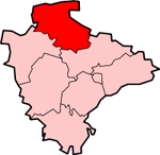
North Devon is the northern part of the English county of Devon
Devon
Devon is a large county in southwestern England. The county is sometimes referred to as Devonshire, although the term is rarely used inside the county itself as the county has never been officially "shired", it often indicates a traditional or historical context.The county shares borders with...
. It is also the name of a local government district
Non-metropolitan district
Non-metropolitan districts, or colloquially shire districts, are a type of local government district in England. As created, they are sub-divisions of non-metropolitan counties in a so-called "two-tier" arrangement...
in Devon. Its council is based in Barnstaple
Barnstaple
Barnstaple is a town and civil parish in the local government district of North Devon in the county of Devon, England, UK. It lies west southwest of Bristol, north of Plymouth and northwest of the county town of Exeter. The old spelling Barnstable is now obsolete.It is the main town of the...
. Other towns and villages in the North Devon District include Braunton
Braunton
Braunton is situated west of Barnstaple, Devon, England and is claimed to be the largest village in England, with a population in 2001 of 7,510. It is home to the nearby Braunton Great Field and Braunton Burrows, a National Nature and UNESCO Biosphere Reserve....
, Fremington
Fremington, Devon
Fremington is a village and civil parish in North Devon three miles west of Barnstaple. It was formerly a borough that sent members to Parliament in the reign of Edward III. The parish includes the neighbouring villages of Bickington and Yelland, the latter only asserting its identity as separate...
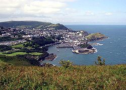
, Ilfracombe
Ilfracombe
Ilfracombe is a seaside resort and civil parish on the North Devon coast, England with a small harbour, surrounded by cliffs.The parish stretches along the coast from 'The Coastguard Cottages' in Hele Bay toward the east and 4 miles along The Torrs to Lee Bay toward the west...
, Instow
Instow
Instow is a village in north Devon, England. It is on the estuary where the rivers Taw and Torridge meet, between the villages of Westleigh and Yelland and on the opposite bank of Appledore....
, South Molton
South Molton
"Molton" redirects here. Or see Molten or Moulton.South Molton is a small town in Devon, England. It is part of the North Devon local government district. The town is on the River Mole. According to the 2001 census the civil parish of South Molton had a population of 4,093.The town was one of...
, Lynton
Lynton
Lynton is a small town in Devon, England. It lies on the northern edge of Exmoor and is located at the top of a gorge above Lynmouth, to which it is connected by the Lynton and Lynmouth Cliff Railway...
and Lynmouth
Lynmouth
Lynmouth is a village in Devon, England, on the north edge of Exmoor.The village straddles the confluence of the West Lyn and East Lyn rivers, in a gorge below Lynton, to which it is connected by the Lynton and Lynmouth Cliff Railway....
. The district was formed on 1 April 1974 as a merger of the Barnstaple municipal borough
Municipal borough
Municipal boroughs were a type of local government district which existed in England and Wales between 1835 and 1974, in Northern Ireland from 1840 to 1973 and in the Republic of Ireland from 1840 to 2002...
, the Ilfracombe and Lynton urban district
Urban district
In the England, Wales and Ireland, an urban district was a type of local government district that covered an urbanised area. Urban districts had an elected Urban District Council , which shared local government responsibilities with a county council....
s, and Barnstaple Rural District and South Molton Rural District.
The wider geographic area of North Devon is divided between North Devon District and the district of Torridge
Torridge
Torridge is a local government district in Devon, England. Its council is based in Bideford. Other towns and villages in the district include Holsworthy, Great Torrington, Hartland and Westward Ho!. The Island of Lundy is administratively part of the District...
, based in Bideford
Bideford
Bideford is a small port town on the estuary of the River Torridge in north Devon, south-west England. It is also the main town of the Torridge local government district.-History:...
.
Population
North Devon is popular with retired people. The 2001 census showed 15 454 (18%) people aged 14 years and under, 54 413 (62%) aged 15–64 and 17 651 (20%) aged 65 and over. For comparison, the same age distributions across England are 19%, 65% and 16% respectively. People over 65 helped to live at home is below the national average. Life expectancy for men, at 76.9, is close to the national average, and increasing more slowly than throughout England. Female life expectancy is good at 82.1; and rising in line with England. There is a gap of 6 years in the life expectancy of people in the highest fifth of wards and the lowest fifth.Governance
North Devon District Council is elected every four years, with currently 43 councillorCouncillor
A councillor or councilor is a member of a local government council, such as a city council.Often in the United States, the title is councilman or councilwoman.-United Kingdom:...
s being elected at each election. From the first election to the council in 1973 to 1987 the council was controlled by independent
Independent (politician)
In politics, an independent or non-party politician is an individual not affiliated to any political party. Independents may hold a centrist viewpoint between those of major political parties, a viewpoint more extreme than any major party, or they may have a viewpoint based on issues that they do...
s. This was followed by a period under Liberal Democrat control until the Conservative Party
Conservative Party (UK)
The Conservative Party, formally the Conservative and Unionist Party, is a centre-right political party in the United Kingdom that adheres to the philosophies of conservatism and British unionism. It is the largest political party in the UK, and is currently the largest single party in the House...
took control at the 2007 election
North Devon Council election, 2007
The 2007 North Devon Council election took place on 3 May 2007 to elect members of North Devon District Council in Devon, England. The whole council was up for election and the Conservative party gained overall control of the council from the Liberal Democrats....
. Following the most recent election in 2011
North Devon Council election, 2011
The 2011 North Devon Council election took place on 5 May 2011 to elect members of North Devon District Council in Devon, England. The whole council was up for election and the Conservative party lost overall control of the council to no overall control....
however the Conservatives lost their majority and a coalition between the Liberal Democrats and independents took control of the council. As of the 2011 election the council is composed of the following councillors:-
| Party | Councillors |
|
| Conservative Party Conservative Party (UK) The Conservative Party, formally the Conservative and Unionist Party, is a centre-right political party in the United Kingdom that adheres to the philosophies of conservatism and British unionism. It is the largest political party in the UK, and is currently the largest single party in the House... |
18 | |
| Liberal Democrats | 14 | |
| Independent Independent (politician) In politics, an independent or non-party politician is an individual not affiliated to any political party. Independents may hold a centrist viewpoint between those of major political parties, a viewpoint more extreme than any major party, or they may have a viewpoint based on issues that they do... |
11 | |
Transport
The area is well served by transport in relation to its neighbours to the east and west, TorridgeTorridge
Torridge is a local government district in Devon, England. Its council is based in Bideford. Other towns and villages in the district include Holsworthy, Great Torrington, Hartland and Westward Ho!. The Island of Lundy is administratively part of the District...
and West Somerset
West Somerset
West Somerset is a local government district in the English county of Somerset. The council covers a largely rural area, with a population of 35,075 in an area of ....
. The rump of the post-Beeching
Beeching Axe
The Beeching Axe or the Beeching Cuts are informal names for the British Government's attempt in the 1960s to reduce the cost of running British Railways, the nationalised railway system in the United Kingdom. The name is that of the main author of The Reshaping of British Railways, Dr Richard...
railway network has left a branch line
Tarka Line
The Tarka Line is a railway line from Exeter to Barnstaple in Devon, England. The line follows the River Creedy, River Yeo and River Taw for some of its route...
to Exeter
Exeter
Exeter is a historic city in Devon, England. It lies within the ceremonial county of Devon, of which it is the county town as well as the home of Devon County Council. Currently the administrative area has the status of a non-metropolitan district, and is therefore under the administration of the...
. The region is linked by three A roads. The primary link is the A361
A361 road
The A361 is a major road in England and at is the longest 3 digit A road in the UK. It runs south from Ilfracombe on the north Devon coast to Barnstaple, turning south-east to Tiverton then, after a break , north east from Taunton in Somerset through Street and Glastonbury, past Frome and then...
(known locally as the Link Road) which was constructed between 1986 and 1989. It heads north-west from the M5 motorway
M5 motorway
The M5 is a motorway in England. It runs from a junction with the M6 at West Bromwich near Birmingham to Exeter in Devon. Heading south-west, the M5 runs east of West Bromwich and west of Birmingham through Sandwell Valley...
, past South Molton
South Molton
"Molton" redirects here. Or see Molten or Moulton.South Molton is a small town in Devon, England. It is part of the North Devon local government district. The town is on the River Mole. According to the 2001 census the civil parish of South Molton had a population of 4,093.The town was one of...
, to Barnstaple, with the classification continuing then northwards along older roads to Ilfracombe
Ilfracombe
Ilfracombe is a seaside resort and civil parish on the North Devon coast, England with a small harbour, surrounded by cliffs.The parish stretches along the coast from 'The Coastguard Cottages' in Hele Bay toward the east and 4 miles along The Torrs to Lee Bay toward the west...
. The modern Link Road continues westwards from Barnstaple as the A39
A39 road
The A39 is an A road in south west England. It runs south-west from Bath in Somerset through Wells, Glastonbury, Street and Bridgwater. It then follows the north coast of Somerset and Devon through Williton, Minehead, Porlock, Lynmouth, Barnstaple, Bideford, Stratton, Camelford, Wadebridge and St...
where it is designated the Atlantic Highway. The eastern section of the A39 links Barnstaple to Lynton
Lynton
Lynton is a small town in Devon, England. It lies on the northern edge of Exmoor and is located at the top of a gorge above Lynmouth, to which it is connected by the Lynton and Lynmouth Cliff Railway...
, then traverses the northern coastal hills of Exmoor
Exmoor
Exmoor is an area of hilly open moorland in west Somerset and north Devon in South West England, named after the main river that flows out of the district, the River Exe. The moor has given its name to a National Park, which includes the Brendon Hills, the East Lyn Valley, the Vale of Porlock and ...
into Somerset
Somerset
The ceremonial and non-metropolitan county of Somerset in South West England borders Bristol and Gloucestershire to the north, Wiltshire to the east, Dorset to the south-east, and Devon to the south-west. It is partly bounded to the north and west by the Bristol Channel and the estuary of the...
.
The other two A roads are the A399, a minor local route between Ilfracombe and South Molton (used as a de facto Barnstaple-bypass to Woolacombe
Woolacombe
Woolacombe is a seaside resort on the coast of North Devon, England, which lies at the mouth of a valley . The beach, which has Blue Flag and Premier Seaside Beach awards for its cleanliness, water quality and facilities, is long, sandy, gently sloping and faces the Atlantic Ocean near the...
), and the A377, which is the main road between Barnstaple and the county town
County town
A county town is a county's administrative centre in the United Kingdom or Ireland. County towns are usually the location of administrative or judicial functions, or established over time as the de facto main town of a county. The concept of a county town eventually became detached from its...
of Devon
Devon
Devon is a large county in southwestern England. The county is sometimes referred to as Devonshire, although the term is rarely used inside the county itself as the county has never been officially "shired", it often indicates a traditional or historical context.The county shares borders with...
, Exeter
Exeter
Exeter is a historic city in Devon, England. It lies within the ceremonial county of Devon, of which it is the county town as well as the home of Devon County Council. Currently the administrative area has the status of a non-metropolitan district, and is therefore under the administration of the...
.
Due to significant peak time traffic delays in Barnstaple, coupled with severe congestion at both peak and non-peak times in the summer when tourist traffic is at its busiest, the Barnstaple Western Bypass
Barnstaple Western Bypass
The Barnstaple Western Bypass is a congestion-relief scheme designed to take road traffic away from the town centre of Barnstaple, a market town in Devon, South West England...
was opened in 2007.
Economy
Due to the historically agricultural nature of the economy, many areas of North Devon were considered deprived. The average income for the district is 73% of the average for the United KingdomUnited Kingdom
The United Kingdom of Great Britain and Northern IrelandIn the United Kingdom and Dependencies, other languages have been officially recognised as legitimate autochthonous languages under the European Charter for Regional or Minority Languages...
as a whole.
The largest employers in the area are the National Health Service
National Health Service
The National Health Service is the shared name of three of the four publicly funded healthcare systems in the United Kingdom. They provide a comprehensive range of health services, the vast majority of which are free at the point of use to residents of the United Kingdom...
, mainly through North Devon District Hospital
North Devon District Hospital
North Devon District Hospital is an NHS district general hospital in the town of Barnstaple, North Devon, England. It has an Accident & Emergency department, an intensive care unit and a day case unit, and is operated by Northern Devon Healthcare NHS Trust. The hospital has 423 beds.-External...
in Barnstaple
Barnstaple
Barnstaple is a town and civil parish in the local government district of North Devon in the county of Devon, England, UK. It lies west southwest of Bristol, north of Plymouth and northwest of the county town of Exeter. The old spelling Barnstable is now obsolete.It is the main town of the...
, and the Ministry of Defence
Ministry of Defence (United Kingdom)
The Ministry of Defence is the United Kingdom government department responsible for implementation of government defence policy and is the headquarters of the British Armed Forces....
, at Royal Marines Base Chivenor
Royal Marines Base Chivenor
Royal Marines Base Chivenor is a British military base used primarily by the Royal Marines. It is situated on the northern shore of the Taw estuary, adjacent to the South West Coast Path, on the north coast of Devon, England....
and Arromanches Camp, Instow
Instow
Instow is a village in north Devon, England. It is on the estuary where the rivers Taw and Torridge meet, between the villages of Westleigh and Yelland and on the opposite bank of Appledore....
, and North Devon Council.
Barnstaple
Barnstaple is on the River TawRiver Taw
The River Taw rises at Taw Head, a spring on the central northern flanks of Dartmoor. It reaches the Bristol Channel away on the north coast of Devon at a joint estuary mouth which it shares with the River Torridge.-Watercourse:...
estuary, and functions both as the main service centre and the administrative centre for North Devon Council
North Devon Council
North Devon Council was created on 1 April 1974 to administer the North Devon District in the county of Devon in south west England. The council's main office is located in the Civic Centre, Barnstaple. It shares this building with Devon County Council, North Devon Magistrates Court and Barnstaple...
. The population of 34,000 excludes the exurbs
Commuter town
A commuter town is an urban community that is primarily residential, from which most of the workforce commutes out to earn their livelihood. Many commuter towns act as suburbs of a nearby metropolis that workers travel to daily, and many suburbs are commuter towns...
of Bickington, Landkey
Landkey
Landkey is a small village in the county of Devon in the south-west of England with a population of 2274. It is situated from the nearest town of Barnstaple.-Origin:...
, Ashford
Ashford, North Devon
Ashford is a village and civil parish in the North Devon district of Devon, England. According to the 2001 census it had a population of 273.-Place-name meaning:...
and Shirwell, suburban villages outside of the main urban area of Barnstaple itself but that are dependent on the main settlement for services and employment.
Ethnicity
The region is one of the most homogenous in England, with 99.0% of the population putting their race on the 2001 census as White. This means North Devon is ranked 318 out of 354 where rank 1 has the lowest percentage of white people and rank 354 has the highest percentage of white people.See also
- North Devon Coast
- South West Coast PathSouth West Coast PathThe South West Coast Path is Britain's longest waymarked long-distance footpath and a National Trail. It stretches for , running from Minehead in Somerset, along the coasts of Devon and Cornwall, to Poole Harbour in Dorset. Since it rises and falls with every river mouth, it is also one of the more...
- Tarka TrailTarka TrailThe Tarka Trail is a series of footpaths and cyclepaths around north Devon, England that follow the route taken by Tarka the Otter in the book of that name. It is a figure-of-eight route, based on Barnstaple, and covers some of path....
- North Devon cattleNorth Devon cattleThe Devon is a breed of cattle from the south west of England. It is a rich red colour, and this gives rise to the popular nicknames of Devon Ruby or Red Ruby...