
.gif)
Stroud (district)
Encyclopedia
Stroud is a local government district
in Gloucestershire
, England
. It is named after its largest town, Stroud
, and has its administrative headquarters in Ebley Mill, in the Ebley area on the outskirts of the town.
 The district is mixed and consists of part of the Cotswolds
and an area of the flat, fertile valley of the River Severn
. The town of Stroud
is by some way the largest in the area. The southern portion of the district is served mostly by its own market towns, chief among which are Dursley
and Wotton-under-Edge
. It was formed under the Local Government Act 1972
, on April 1, 1974, by a merger of Nailsworth
and Stroud urban district
s, Dursley Rural District, Stroud Rural District, and parts of Gloucester Rural District
, Sodbury Rural District and Thornbury Rural District
.
The area is rich in Iron Age
and Roman
remnants and is of particular interest to archaeologists for its Neolithic
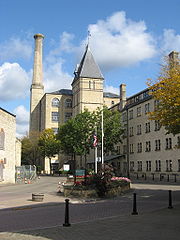
burial grounds, of which there are over 100. Much of its wealth was built on the cloth industry during the Victorian era, and its many mills, most of which are now listed buildings, survive as testament to this.
Much of the landscape in this area is designated as an Area of Outstanding Natural Beauty
. The esteemed Cotswold Way
walk leads through the area. There are gliding
clubs at Aston Down
and Nympsfield
.
lost its overall control of the council following four Labour
gains, including that of former Stroud MP David Drew after he won in the Farmhill and Paganhill ward. However, soon after the election, the Conservatives were able to woo back into the party Ray Apperley, who had previously resigned the Tory whip over the disclosure of expenses, in order to hold a majority on the Council. This means that the Conservatives now hold a majority of one. Following the fallout of the 2011 election the council is composed of the following councillor
s:
Non-metropolitan district
Non-metropolitan districts, or colloquially shire districts, are a type of local government district in England. As created, they are sub-divisions of non-metropolitan counties in a so-called "two-tier" arrangement...
in Gloucestershire
Gloucestershire
Gloucestershire is a county in South West England. The county comprises part of the Cotswold Hills, part of the flat fertile valley of the River Severn, and the entire Forest of Dean....
, England
England
England is a country that is part of the United Kingdom. It shares land borders with Scotland to the north and Wales to the west; the Irish Sea is to the north west, the Celtic Sea to the south west, with the North Sea to the east and the English Channel to the south separating it from continental...
. It is named after its largest town, Stroud
Stroud, Gloucestershire
Stroud is a market town and civil parish in the county of Gloucestershire, England. It is the main town in Stroud District.Situated below the western escarpment of the Cotswold Hills at the meeting point of the Five Valleys, the town is noted for its steep streets and cafe culture...
, and has its administrative headquarters in Ebley Mill, in the Ebley area on the outskirts of the town.
Cotswolds
The Cotswolds are a range of hills in west-central England, sometimes called the Heart of England, an area across and long. The area has been designated as the Cotswold Area of Outstanding Natural Beauty...
and an area of the flat, fertile valley of the River Severn
River Severn
The River Severn is the longest river in Great Britain, at about , but the second longest on the British Isles, behind the River Shannon. It rises at an altitude of on Plynlimon, Ceredigion near Llanidloes, Powys, in the Cambrian Mountains of mid Wales...
. The town of Stroud
Stroud, Gloucestershire
Stroud is a market town and civil parish in the county of Gloucestershire, England. It is the main town in Stroud District.Situated below the western escarpment of the Cotswold Hills at the meeting point of the Five Valleys, the town is noted for its steep streets and cafe culture...
is by some way the largest in the area. The southern portion of the district is served mostly by its own market towns, chief among which are Dursley
Dursley
Dursley is a market town in Gloucestershire, England. It is under the North East flank of Stinchcombe Hill , and about 6 km South East of the River Severn. The town is adjacent with Cam which, though a village, is a community of double the size...
and Wotton-under-Edge
Wotton-under-Edge
Wotton-under-Edge is a market town within the Stroud district of Gloucestershire, England. Located near the southern end of the Cotswolds, the Cotswold Way long-distance footpath passes through the town. Standing on the B4058 Wotton is about from the M5 motorway. The nearest railway station is...
. It was formed under the Local Government Act 1972
Local Government Act 1972
The Local Government Act 1972 is an Act of Parliament in the United Kingdom that reformed local government in England and Wales on 1 April 1974....
, on April 1, 1974, by a merger of Nailsworth
Nailsworth
Nailsworth is a town in Gloucestershire, England, lying in one of the Stroud Valleys in the Cotswolds. It has a population of around 6,600 people and lies on the A46 road....
and Stroud urban district
Urban district
In the England, Wales and Ireland, an urban district was a type of local government district that covered an urbanised area. Urban districts had an elected Urban District Council , which shared local government responsibilities with a county council....
s, Dursley Rural District, Stroud Rural District, and parts of Gloucester Rural District
Gloucester Rural District
Gloucester was, from 1894 to 1974, a rural district in the administrative county of Gloucestershire, England. The district did not include the City of Gloucester, which was a separate county borough. In 1935 Gloucester RD was more than doubled in size....
, Sodbury Rural District and Thornbury Rural District
Thornbury Rural District
Thornbury Rural District was a rural district council centred around Thornbury in the south of Gloucestershire. It was abolished in 1974 and the majority of it transferred into the new county of Avon, as part of the new district of Northavon....
.
The area is rich in Iron Age
Iron Age
The Iron Age is the archaeological period generally occurring after the Bronze Age, marked by the prevalent use of iron. The early period of the age is characterized by the widespread use of iron or steel. The adoption of such material coincided with other changes in society, including differing...
and Roman
Ancient Rome
Ancient Rome was a thriving civilization that grew on the Italian Peninsula as early as the 8th century BC. Located along the Mediterranean Sea and centered on the city of Rome, it expanded to one of the largest empires in the ancient world....
remnants and is of particular interest to archaeologists for its Neolithic
Neolithic
The Neolithic Age, Era, or Period, or New Stone Age, was a period in the development of human technology, beginning about 9500 BC in some parts of the Middle East, and later in other parts of the world. It is traditionally considered as the last part of the Stone Age...
burial grounds, of which there are over 100. Much of its wealth was built on the cloth industry during the Victorian era, and its many mills, most of which are now listed buildings, survive as testament to this.
Much of the landscape in this area is designated as an Area of Outstanding Natural Beauty
Area of Outstanding Natural Beauty
An Area of Outstanding Natural Beauty is an area of countryside considered to have significant landscape value in England, Wales or Northern Ireland, that has been specially designated by the Countryside Agency on behalf of the United Kingdom government; the Countryside Council for Wales on...
. The esteemed Cotswold Way
Cotswold Way
The Cotswold Way is a long-distance footpath, running along the Cotswold Edge escarpment of the Cotswold Hills in England. It was officially inaugurated as a National Trail on 24 May 2007 and several new rights of way have been created.-History:...
walk leads through the area. There are gliding
Gliding
Gliding is a recreational activity and competitive air sport in which pilots fly unpowered aircraft known as gliders or sailplanes using naturally occurring currents of rising air in the atmosphere to remain airborne. The word soaring is also used for the sport.Gliding as a sport began in the 1920s...
clubs at Aston Down
Aston Down
RAF Aston Down is a former Royal Air Force station near Minchinhampton, Gloucestershire, South West England. It was used by the RAF from the First World War until 1967, since when it has been the home of the Cotswold Gliding Club...
and Nympsfield
Nympsfield
Nympsfield is a village and civil parish in the English county of Gloucestershire. It is located around six miles south-west of the town of Stroud. As well as Nympsfield village, the parish also contains the hamlet of Cockadilly....
.
Politics
Elections to the district council are held in three out of every four years, with one third of the seats on the council being elected at each election. At the 2011 election, the ConservativesConservative Party (UK)
The Conservative Party, formally the Conservative and Unionist Party, is a centre-right political party in the United Kingdom that adheres to the philosophies of conservatism and British unionism. It is the largest political party in the UK, and is currently the largest single party in the House...
lost its overall control of the council following four Labour
Labour Party (UK)
The Labour Party is a centre-left democratic socialist party in the United Kingdom. It surpassed the Liberal Party in general elections during the early 1920s, forming minority governments under Ramsay MacDonald in 1924 and 1929-1931. The party was in a wartime coalition from 1940 to 1945, after...
gains, including that of former Stroud MP David Drew after he won in the Farmhill and Paganhill ward. However, soon after the election, the Conservatives were able to woo back into the party Ray Apperley, who had previously resigned the Tory whip over the disclosure of expenses, in order to hold a majority on the Council. This means that the Conservatives now hold a majority of one. Following the fallout of the 2011 election the council is composed of the following councillor
Councillor
A councillor or councilor is a member of a local government council, such as a city council.Often in the United States, the title is councilman or councilwoman.-United Kingdom:...
s:
| Year | Conservative Conservative Party (UK) The Conservative Party, formally the Conservative and Unionist Party, is a centre-right political party in the United Kingdom that adheres to the philosophies of conservatism and British unionism. It is the largest political party in the UK, and is currently the largest single party in the House... | Labour Labour Party (UK) The Labour Party is a centre-left democratic socialist party in the United Kingdom. It surpassed the Liberal Party in general elections during the early 1920s, forming minority governments under Ramsay MacDonald in 1924 and 1929-1931. The party was in a wartime coalition from 1940 to 1945, after... | Liberal Democrat | Green Green Party of England and Wales The Green Party of England and Wales is a political party in England and Wales which follows the traditions of Green politics and maintains a strong commitment to social progressivism. It is the largest Green party in the United Kingdom, containing within it various regional divisions including... | Independent Independent (politician) In politics, an independent or non-party politician is an individual not affiliated to any political party. Independents may hold a centrist viewpoint between those of major political parties, a viewpoint more extreme than any major party, or they may have a viewpoint based on issues that they do... |
|---|---|---|---|---|---|
| 2011 | 26 | 11 | 6 | 6 | 2 |