

M4 motorway
Encyclopedia
The M4 motorway links London with South Wales
. It is part of the unsigned European route E30
. Other major places directly accessible from M4 junctions are Reading
, Swindon
, Bristol
, Newport
, Cardiff
and Swansea
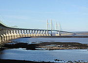
. Originally referred to as the London-South Wales Motorway, the English section was constructed between 1965 and 1971, the Welsh section was completed in 1993 and the Second Severn Crossing
opened in 1996.
The M4 runs close to the A4 from London to Bristol. After crossing the River Severn
it follows the A48 through Wales, using the Brynglas Tunnels
at Junction 25a, Newport
and terminates just north of Pontarddulais
. The route of the M4 is known as the M4 corridor
.
 A new road from London to South Wales was first proposed in the 1930s, and the Ministry of Transport
announced plans for the M4 as one of the first major post-war trunk road improvement projects in 1956.
The motorway was built in several stages. In the 1960s two sections were built, one extending from the London end to near Maidenhead
, one from north of Bath to west of Newport, including the Severn Bridge
(opened in 1966 and now part of the M48
). The Port Talbot
by-pass, also built in the 1960s and now part of the M4, was originally the A48(M) motorway
, a number now allocated to a short section of motorway near Cardiff. The Ministry of Transport originally intended that the M4 would terminate at Tredegar Park
west of Newport, and it was only following the creation of the Welsh Office
that the Government became committed to a high-standard dual carriageway to Pont Abraham in Carmarthenshire
.
 The English section of the motorway was completed on 22 December 1971 when the 50 miles (80.5 km) stretch between junctions 9 and 15 (Maidenhead
and Swindon
) was opened to traffic. The Welsh section was completed in 1993, when the Briton Ferry
motorway bridge opened. The Second Severn Crossing
opened in 1996, together with new link motorways on either side of the estuary to divert the M4 over the new crossing. The existing route over the Severn Bridge was redesignated the M48, and the new M49
was opened to connect the new crossing to the M5
.
In June 1999 the section of the third lane (the lane nearest the central reservation) between junctions 2 and 3 was converted to a bus lane
and opened as a pilot scheme. The scheme was made permanent in 2001. A lower speed limit was introduced along the bus lane section at the same time. The bus lane was scrapped at the end of 2010 and the third lane was returned to all-traffic use.
In April 2005 speed checks carried out by police camera vans
between junction 14 and junction 18 resulted in a public protest, involving a go-slow of several hundred vehicles along the affected sections of the motorway.
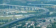
Between 2007 and January 2010 the section from Castleton (Junction 29) to and Coryton (Junction 32) was widened to 6 lanes. The scheme was officially opened in 25 January 2010 by the Deputy First Minister. Subsequent to opening there were occasional works with associated lane restrictions.
During 2009 the Newport section of the motorway between junctions 23a and 29 was upgraded with a new concrete central barrier. In February 2010 it was proposed that the M4 in South Wales would become the first hydrogen highway
with hydrogen station
s provided along the route with an aspiration for further stations to be provided along the M4 into South West England
over time. A similar claim was made for a 30 miles (48.3 km) section of road in Scotland close to Aberdeen
in September 2009 with refueling points at Bridge of Don, Ellon and Peterhead.
In October 2010 the new transport secretary, Philip Hammond
announced that the bus lane would be suspended for 18 months from 24 December 2010 to be brought back for the 2012 Summer Olympics
after which it was likely to be scrapped permanently.
the River Severn
via a toll bridge
, the second of only two on the UK motorway network – the first was the original Severn Bridge, now the M48. Tolls in Wales are charged in one direction only - westbound. Drivers therefore have to pay to enter Wales, but not to enter England.
turnoff and the elevated section eastbound only when approaching the toll plaza on the Severn Crossing to protect tolling staff moving between the tolling booths, temporarily during road works between Junction 24 and Junction 25A enforced with average-speed-check cameras. on the Port Talbot elevated section between junction 40 and junction 41.
on the eastbound (London-bound) carriageway from junction 3 (A312) to the start of the elevated 2-lane section near Brentford
, covering part of the 15 miles (24.1 km) journey between Heathrow Airport and central London. The lane which had no intermediate exits was for use by buses, coaches, motorbikes, emergency vehicles and licensed taxis but not mini-cabs. It was used by 7% of vehicles which carried 21% of the people.
The lane was restored for normal motorway running at the end of 2010 for 18 months using a Experimental Traffic Order and will be re-established for the duration of the 2012 Summer Olympics
with the intention that it will then be removed permanently.
that improves drainage and reduces noise. When driving in heavy rain drivers notice a reduction in road spray from other vehicles and improved visibility. This special surface was publicised in an episode of the BBC's Tomorrow's World programme. This was the site of the first trial of the new road surface when it was laid down in 1993.
's Golden Mile
. This section was designed to have a heated road surface to reduce icing in winter, however, due to the high costs in preventing icing by this method the heating is no longer used.
s in the UK, including the first UK example at the junction with the M5 (J20/"Almondsbury Interchange
") and the other at the junction with the M25 (J4B). Junction 4B also has to make provision for a railway line passing beneath the M4. Due to the nature of such junctions, it is impossible to make a U-turn at J20 or J4B.
at Junction 25a, Newport
, which is the only two bored tunnel on the UK motorway network.
, Berkshire
.
West of Junction 13 on the eastbound carriageway there are a set of sliproads signposted "Works Unit Only". The signs have red borders, implying a military exit. It is a back entrance to RAF Welford
, a Second World War airfield and now an RAF/USAF military installation mainly used for storing munitions. The M4 entrance allows easier access for the large vehicles used to carry the munitions.
Junction 27 (High Cross
) is a normal grade-separated roundabout junction. However the on-bound slip roads point in the opposite direction to the intended direction of travel. Due to the topology of the landscape, both sets of slip roads are conjoined on either side of the roundabout. To travel westbound the driver must use an eastbound-facing slip road before looping around 180 degrees to join the westbound carriageway.
Junctions 30-31 (East Cardiff) were set aside for intermediate additional interchanges at the time on construction. Junction 30 (Cardiff Gate
) has since been added but there are no current plans to construct Junction 31 (A469 road
).
Junction 39 does actually exist, but can only be used to access the motorway from a single slip road onto the westbound carriageway from the A48 at junction 38. There is no exit from the motorway at this junction.
Junction 41 refers to two different junctions in two different directions, their movements not complementary. In the westbound direction, 41 is indicated as a spur leading to the roundabout in Briton Ferry
formerly known as 41A, and the original bridge over the River Neath
, which would allow access onto the stretch of the M4 from junction 43 westward. In the eastbound direction, 41 is indicated as an exit-only route to the A48 towards Port Talbot
. As a result, it is possible in both directions to travel almost 2 miles (3.2 km) in the same direction having both joined and subsequently left the motorway at "Junction 41".
Junction 44 is unusual in that the eastbound entrance dives under the inside of the junction, effectively a creating a "right-turn" on a roundabout
.
, is in the process of being extensively developed with a new four-lane motorway junction and the construction of two extra road bridges around the existing junction and other works. Work started in 2008 and is expected to be completed by summer 2010. The £65m scheme includes work to the Mereoak roundabout and part of the A33 Swallowfield Bypass in Shinfield conversion, and also the conversion of the two existing bridges, one of which will be available only for pedestrians and cyclists and the other for buses. It will also involve the movement of the local Highways Agency
and Fire Service
offices, build a long footbridge network, a special bus-lane
and a new gyratory. It will also install sound barriers for nearby residential areas, some of which have already been completed. In April 2008, the decision to preserve a rare Vickers Machine-gun
Pillbox and turn it into a bat roost was announced by the developers.
interchange
, which was originally granted planning permission in September 1991 (but subsequently expired) have been rekindled after proposals for a new business park on a 125 acres (51 ha) site north of the M4 were submitted to Cardiff Council
. The developers of the business park, St Modwen Developments, would likely fund the new junction, which would be on the A469
.
were first announced by the Welsh Office
in 1991, but made little progress. The Welsh Assembly Government
revived the scheme as the 'New M4' tolled bypass in 2007 but later abandoned it for financial reasons. An extension to the Newport Southern Distributor Road
through the old Corus steel works is being considered. This road is already a dual carriageway but not open to the public.
There have been calls to close the slip roads at Junction 40 and 41 (at Port Talbot) to 'improve traffic flow'. The motorway is only two lanes in this stretch and is a major traffic congestion blackspot. Junctions 40 and 41 (at Port Talbot) have very short slip roads which are not up to modern standards. The Port Talbot peripheral distributor road
is under development, which should divert local traffic away from the M4. In future, it is hoped to extend the M4 to Carmarthen, but this depends on financing. A new Junction, 15A, is being considered by Wiltshire Council and this would give access to South and Central Swindon as well as to Wroughton, Marlborough and Devizes via the existing A4361.
|- align="center" bgcolor="0080d0" style="color: white;font-size:120%;"
| colspan="4" | M4 Motorway
|-
!scope=col|km
!scope=col abbr="Eastbound"|Eastbound exits (B Carriageway)
!scope=col|Junction
!scope=col abbr="Westbound"|Westbound exits (A Carriageway)
|-align="center"
|
|rowspan=2|Road becomes A4 to Central London
|rowspan=2|J1
51°29′22"N 0°16′40"W Eastern end of M1
| North Circular A406
South Circular A205
Chiswick
A315
Non-motorway traffic
|-align="center"
|11.8
| A4 from Central London
becomes the M4
Start of motorway
|-align="center"
|13.4
13.7
| North Circular A406
South Circular A205
Chiswick
A315
|J2
| Staines
, Hounslow
, Brentford
A4
|-align="center"
|
|Heston services
|Services
|Heston services
|-align="center"
|21.5
22.1
| Heathrow
(Terminals 4
, 5 & Cargo), Hayes
, Harrow
, Hounslow
A312
|J3
| Heathrow
(Terminals 4
, 5 & Cargo), Hayes
, Harrow
, Hounslow
A312
|-align="center"
|24.5
25.2
| Heathrow
(Terminals 1, 2 & 3) (A4)
Uxbridge
(A408)
|J4a
| Heathrow
(Terminals 1, 2 & 3) (A4)
Uxbridge
(A408)
|-align="center"
|27.0
28.5
| Heathrow
(Terminals 4
, 5 & Cargo), Gatwick Airport, Watford
, Oxford
, Stansted Airport (M40
, M1
, M11
, M3, M23
) M25
|J4b
51°29′41"N 0°29′44"W Intersection of M25 and M4
| Heathrow
(Terminals 4
, 5 & Cargo), Gatwick Airport, Maidstone
, Watford
, Oxford
, Stansted Airport (M40
, M1
, M11
, M3, M23
, M20
) M25
|-align="center"
| 30.7
31.4
| Colnbrook
, Langley
A4
Eton
, Datchet
B470
| J5
| Colnbrook
, Langley
A4, Datchet
B470
|-align="center"
| 36.8
37.4
| Slough (Central)
A355
Windsor
A322
|J6
| Slough (Central)
A355
Windsor
A322
|-align="center"
| 39.8
40.3
| Slough (West)
A4
|J7
| Slough (West)
A4
|-align="center"
| 44.7
45.4
| High Wycombe
, Henley
A404(M)
Maidenhead
A308(M)
|J8/9
| High Wycombe
, Henley
A404(M)
Maidenhead
A308(M)
|-align="center"
| 56.4
57.6
| Reading (East)
, Wokingham
, Bracknell
A329(M)
|J10
| Reading (East)
, Wokingham
, Bracknell
A329(M)
|-align="center"
|65.4
66.3
| Basingstoke
, Reading (Central)
A33
|J11
| Basingstoke
, Reading (C & S)
A33
|-align="center"
|
|Reading services
|Services
|Reading services
|-align="center"
| 72.9
73.5
| Reading (West)
, Theale
A4
|J12
| Reading (West)
, Theale
A4
|-align="center"
|91.5
92.1
| Newbury
, Oxford
A34
Chieveley services
|J13
Services
51°27′14"N 1°18′52"W Intersection of M4 and A34(E05)
| Newbury
, Oxford
A34
Chieveley services
|-align="center"
|103.7
104.3
| Hungerford
, Wantage
A338
|J14
| Hungerford
, Wantage
A338
|-align="center"
|110.5
|Membury services
|Services
|Membury services
|-align="center"
|122.9
124.0
| Swindon
(East) A419
Marlborough A346
Oxford
(A420
)
|J15
| Swindon
A419
, Marlborough A346
|-align="center"
|132.6
133.2
| Swindon
(West), Royal Wootton Bassett, RAF Lyneham
, Calne
A3102
|J16
| Swindon (West)
, Royal Wootton Bassett, RAF Lyneham
, Calne
A3102
|-align="center"
|152.5
153.4
| Chippenham
A350
Cirencester
A429
|J17
| Chippenham
A350
Cirencester
A429
|-align="center"
|155.7
|Leigh Delamere services
|Services
|Leigh Delamere services
|-align="center"
|168.8
170.0
| Bath, Stroud
A46
|J18
| Bath, Stroud
A46
|-align="center"
|181.5
182.1
| Bristol
M32
|J19
| Bristol
M32
|-align="center"
|186.3
187.2
| The SOUTH WEST, Bristol
(West), The MIDLANDS, Gloucester
M5
Almondsbury Interchange
|J20
51°33′01"N 2°33′11"W Almondburty Interchange - Intersection of M4 and M5
| The SOUTH WEST, Bristol (West)
M5(S)
The MIDLANDS, Gloucester
M5(N)
|-align="center"
|189.5
190.0
|No access
|J21
| Chepstow
M48
|-align="center"
|195.2
195.7
| Avonmouth
M49
The SOUTH WEST, Bridgwater
, Exeter
(M5
South)
|J22
| Avonmouth
M49
|-align="center"
|195.9
199.8
|England

| Second Severn Crossing
51°34′21"N 2°41′31"W Second Severn Crossing
| Wales

|-align="center"
|204.4
| No tolls
| Tolls
| Toll Booth
|-align="center"
|208.0
| Chepstow
M48
|J23
|No access
|-align="center"
|211.4
212.8
| Magor
, Caldicot
B4245
Magor services
|J23a
Services
| Magor
, Caldicot
B4245
Magor services
|-align="center"
|217.0
218.3
| City centre
A48
Newport
(East) B4237
Monmouth
A449
The MIDLANDS (M50
)
|J24
| City centre
A48
Newport
(East) B4237
Monmouth
A449
|-align="center"
|222.0
|No access
|J25
| Caerleon
B4596
|-align="center"
|222.6
|No access
|J25a
| Newport
, Cwmbran
A4042
|-align="center"
|223.4
223.8
|Brynglas Tunnels
|Tunnel
|Brynglas Tunnels
|-align="center"
|223.8
224.5
| Newport
, Cwmbran
, Caerleon
A4051
|J26
| Newport
A4051
|-align="center"
|226.6
227.6
| High Cross
B4591
|J27
| High Cross
B4591
|-align="center"
|228.5
230.0
| Newport
A48
Risca
, Brynmawr
A467
|J28
| Newport
A48
Risca
, Brynmawr
A467
|-align="center"
|231.1
|No access
|J29
| Cardiff East
and South
A48(M)
|-align="center"
|236.0
237.0
| Cardiff East
A4232
Cardiff Gate services
|J30
Services
| Cardiff East
A4232
Cardiff Gate services
|-align="center"
|244.5
246.1
| Cardiff North
, Merthyr Tydfil
A470
|J32
| Cardiff North
, Merthyr Tydfil
A470
|-align="center"
|250.1
251.1
| Cardiff West
, Cardiff International Airport
, Barry, Penarth
A4232
Cardiff West services
|J33
Services
| Cardiff West
, Cardiff International Airport
, Barry, Penarth
A4232
Cardiff West services
|-align="center"
|253.5
254.4
| Llantrisant
, Rhondda
A4119
|J34
| Llantrisant
, Rhondda
A4119
|-align="center"
|263.7
264.5
| Pen-coed
A473
|J35
| Pen-coed
, Bridgend
A473
|-align="center"
|269.6
270.8
| Bridgend
A4061
Maesteg
A4063
Sarn Park services
|J36
Services
| Bridgend
A4061
Maesteg
A4063
Sarn Park services
|-align="center"
|278.1
279.3
| Porthcawl
, Pyle
A4229
|J37
| Porthcawl
, Pyle
A4229
|-align="center"
|284.9
285.3
| Port Talbot
A48
|J38
| Port Talbot
A48
|-align="center"
|286.9
|No access (on-ramp only)
|J39
|No access
|-align="center"
|289.2
289.6
| Port Talbot
A4107
|J40
| Port Talbot
A4107
|-align="center"
|291.1
291.8
| Port Talbot
A48
|J41
| Port Talbot
, Baglan
A48
|-align="center"
|295.9
297.3
| Swansea
A483
Briton Ferry
A48
|J42
| Swansea
A483
|-align="center"
|297.5
298.8
| Neath
, Merthyr Tydfil
A465
|J43
| Neath
, Merthyr Tydfil
A465
|-align="center"
|300.9
301.6
| Swansea
A48
|J44
| Swansea
A48
|-align="center"
| 303.9
304.7
| Swansea
, Pontardawe
, Morriston
, Clydach A4067
|J45
| Swansea
, Pontardawe
, Morriston
, Clydach A4067
|-align="center"
| 307.0
308.0
| Swansea
, Llangyfelach
B4489
|J46
| Swansea
, Llangyfelach
B4489
|-align="center"
|309.6
310.7
| Swansea
A483
Pontarddulais
A48
Penllergaer
, Gorseinon
A4240
Swansea services
|J47
Services
| Swansea
A483
Pontarddulais
A48
Penllergaer
, Gorseinon
A4240
Swansea services
|-align="center"
|316.0
317.2
| Pontarddulais
, Llanelli
A4138
|J48
| Pontarddulais
, Llanelli
A4138
|-align="center"
| 320.6
| Start of motorway
|J49
Terminus
Services
51°44′42"N 4°03′54"W Western end of M1
| Carmarthen
A48
Ammanford A483
Pont Abraham services
|-
|colspan=4 align=center|Data from driver location signs and location marker posts
are used to provide distance and carriageway identification information. Where a junction spans several hundred metres and the data is available, both the start and finish values for the junction are shown.
|-
Coordinate list
South Wales
South Wales is an area of Wales bordered by England and the Bristol Channel to the east and south, and Mid Wales and West Wales to the north and west. The most densely populated region in the south-west of the United Kingdom, it is home to around 2.1 million people and includes the capital city of...
. It is part of the unsigned European route E30
European route E30
European route E 30 is an A-Class West-East European route, extending from the southern Irish port of Cork in the west to the Russian city of Omsk in the east...
. Other major places directly accessible from M4 junctions are Reading
Reading, Berkshire
Reading is a large town and unitary authority area in England. It is located in the Thames Valley at the confluence of the River Thames and River Kennet, and on both the Great Western Main Line railway and the M4 motorway, some west of London....
, Swindon
Swindon
Swindon is a large town within the borough of Swindon and ceremonial county of Wiltshire, in South West England. It is midway between Bristol, west and Reading, east. London is east...
, Bristol
Bristol
Bristol is a city, unitary authority area and ceremonial county in South West England, with an estimated population of 433,100 for the unitary authority in 2009, and a surrounding Larger Urban Zone with an estimated 1,070,000 residents in 2007...
, Newport
Newport
Newport is a city and unitary authority area in Wales. Standing on the banks of the River Usk, it is located about east of Cardiff and is the largest urban area within the historic county boundaries of Monmouthshire and the preserved county of Gwent...
, Cardiff
Cardiff
Cardiff is the capital, largest city and most populous county of Wales and the 10th largest city in the United Kingdom. The city is Wales' chief commercial centre, the base for most national cultural and sporting institutions, the Welsh national media, and the seat of the National Assembly for...
and Swansea
Swansea
Swansea is a coastal city and county in Wales. Swansea is in the historic county boundaries of Glamorgan. Situated on the sandy South West Wales coast, the county area includes the Gower Peninsula and the Lliw uplands...
. Originally referred to as the London-South Wales Motorway, the English section was constructed between 1965 and 1971, the Welsh section was completed in 1993 and the Second Severn Crossing
Second Severn Crossing
The Second Severn Crossing is a bridge which carries the M4 motorway over the River Severn between England and Wales, inaugurated on 5 June 1996 by HRH The Prince of Wales to augment the traffic capacity of the original Severn Bridge built in 1966...
opened in 1996.
The M4 runs close to the A4 from London to Bristol. After crossing the River Severn
River Severn
The River Severn is the longest river in Great Britain, at about , but the second longest on the British Isles, behind the River Shannon. It rises at an altitude of on Plynlimon, Ceredigion near Llanidloes, Powys, in the Cambrian Mountains of mid Wales...
it follows the A48 through Wales, using the Brynglas Tunnels
Brynglas Tunnels
The Brynglas Tunnels carry the M4 motorway under Brynglas Hill in Newport. The twin-bored tunnels were the first tunnels in the British motorway network and are still the only bored tunnels....
at Junction 25a, Newport
Newport
Newport is a city and unitary authority area in Wales. Standing on the banks of the River Usk, it is located about east of Cardiff and is the largest urban area within the historic county boundaries of Monmouthshire and the preserved county of Gwent...
and terminates just north of Pontarddulais
Pontarddulais
Pontarddulais is a community and town in the City and County of Swansea, Wales. It is situated north west of Swansea city centre. It falls within the Pontarddulais ward.-Overview:...
. The route of the M4 is known as the M4 corridor
M4 corridor
The M4 corridor is the area in the United Kingdom adjacent to the M4 motorway, which runs from London to South Wales. The area is a major hub for high-technology companies...
.
History
Department for Transport
In the United Kingdom, the Department for Transport is the government department responsible for the English transport network and a limited number of transport matters in Scotland, Wales and Northern Ireland which are not devolved...
announced plans for the M4 as one of the first major post-war trunk road improvement projects in 1956.
The motorway was built in several stages. In the 1960s two sections were built, one extending from the London end to near Maidenhead
Maidenhead
Maidenhead is a town and unparished area within the Royal Borough of Windsor and Maidenhead, in Berkshire, England. It lies on the River Thames and is situated west of Charing Cross in London.-History:...
, one from north of Bath to west of Newport, including the Severn Bridge
Severn Bridge
The Severn Bridge is a suspension bridge spanning the River Severn between South Gloucestershire, just north of Bristol, England, and Monmouthshire in South Wales, via Beachley, a peninsula between the River Severn and River Wye estuary. It is the original Severn road crossing between England and...
(opened in 1966 and now part of the M48
M48 motorway
The M48 is a motorway in Great Britain joining Gloucestershire and Monmouthshire over the original Severn Bridge. The M48 is anomalously numbered, as it is entirely to the west of the M5 motorway and its number should really therefore begin with 5.-Route:...
). The Port Talbot
Port Talbot
Port Talbot is a town in Neath Port Talbot, Wales. It had a population of 35,633 in 2001.-History:Port Talbot grew out of the original small port and market town of Aberafan , which belonged to the medieval Lords of Afan. The area of the parish of Margam lying on the west bank of the lower Afan...
by-pass, also built in the 1960s and now part of the M4, was originally the A48(M) motorway
A48(M) motorway
The A48 is a motorway in Wales between Cardiff and Newport. It is a spur off the M4 into eastern Cardiff. It is long and is a 2-lane motorway throughout its length. At St Mellons it runs continuously into a further of the dual-carriageway A48, which also features hard shoulders.It opened in...
, a number now allocated to a short section of motorway near Cardiff. The Ministry of Transport originally intended that the M4 would terminate at Tredegar Park
Tredegar Park
Tredegar Park is a large municipal park located near the housing estates of Duffryn, Maesglas, and Gaer in the city of Newport in South Wales.- History :...
west of Newport, and it was only following the creation of the Welsh Office
Welsh Office
The Welsh Office was a department in the Government of the United Kingdom with responsibilities for Wales. It was established in April 1965 to execute government policy in Wales, and was headed by the Secretary of State for Wales, a post which had been created in October 1964...
that the Government became committed to a high-standard dual carriageway to Pont Abraham in Carmarthenshire
Carmarthenshire
Carmarthenshire is a unitary authority in the south west of Wales and one of thirteen historic counties. It is the 3rd largest in Wales. Its three largest towns are Llanelli, Carmarthen and Ammanford...
.
Maidenhead
Maidenhead is a town and unparished area within the Royal Borough of Windsor and Maidenhead, in Berkshire, England. It lies on the River Thames and is situated west of Charing Cross in London.-History:...
and Swindon
Swindon
Swindon is a large town within the borough of Swindon and ceremonial county of Wiltshire, in South West England. It is midway between Bristol, west and Reading, east. London is east...
) was opened to traffic. The Welsh section was completed in 1993, when the Briton Ferry
Briton Ferry
Briton Ferry is a town and community in the county borough of Neath Port Talbot, Wales. The town encompasses the electoral wards of Briton Ferry East and Briton Ferry West....
motorway bridge opened. The Second Severn Crossing
Second Severn Crossing
The Second Severn Crossing is a bridge which carries the M4 motorway over the River Severn between England and Wales, inaugurated on 5 June 1996 by HRH The Prince of Wales to augment the traffic capacity of the original Severn Bridge built in 1966...
opened in 1996, together with new link motorways on either side of the estuary to divert the M4 over the new crossing. The existing route over the Severn Bridge was redesignated the M48, and the new M49
M49 motorway
The M49 motorway is a 5 mile motorway west of Bristol, England, that forms a shortcut between the M5 motorway and the Second Severn Bridge on the M4 motorway. It was constructed in 1996, at the same time as the bridge and is unique as it is only accessible from other motorways...
was opened to connect the new crossing to the M5
M5
-Roads:* M5 motorway, England* M5 South Western Motorway, Sydney, Australia* Metroad 5 , Brisbane, Australia, comprising the M5 Centenary Freeway and M5 Western Freeway* M5 motorway , Northern Ireland* M5 motorway...
.
In June 1999 the section of the third lane (the lane nearest the central reservation) between junctions 2 and 3 was converted to a bus lane
M4 bus lane
The M4 bus lane was a controversial bus lane on the eastbound carriageway of the M4 motorway between Heathrow Airport and central London. It operated between junction 3 to the start of the elevated 2-lane section near Brentford...
and opened as a pilot scheme. The scheme was made permanent in 2001. A lower speed limit was introduced along the bus lane section at the same time. The bus lane was scrapped at the end of 2010 and the third lane was returned to all-traffic use.
In April 2005 speed checks carried out by police camera vans
Mobile speed camera
A mobile speed camera is speed limit enforcement device used in the United Kingdom to refer to a road vehicle fitted with speed camera equipment which can park at the side of the road, or on overbridges to monitor the speed of passing traffic....
between junction 14 and junction 18 resulted in a public protest, involving a go-slow of several hundred vehicles along the affected sections of the motorway.
Between 2007 and January 2010 the section from Castleton (Junction 29) to and Coryton (Junction 32) was widened to 6 lanes. The scheme was officially opened in 25 January 2010 by the Deputy First Minister. Subsequent to opening there were occasional works with associated lane restrictions.
During 2009 the Newport section of the motorway between junctions 23a and 29 was upgraded with a new concrete central barrier. In February 2010 it was proposed that the M4 in South Wales would become the first hydrogen highway
Hydrogen highway
A hydrogen highway is a chain of hydrogen-equipped filling stations and other infrastructure along a road or highway which allow hydrogen powered cars to travel. It is an element of the hydrogen infrastructure that is generally assumed to be a pre-requisite for mass utilization of hydrogen cars....
with hydrogen station
Hydrogen station
A hydrogen station is a storage or filling station for hydrogen, usually located along a road or hydrogen highway, or at home as part of the distributed generation resources concept. The stations are usually intended to power vehicles, but can also be used to power small devices. Vehicles use...
s provided along the route with an aspiration for further stations to be provided along the M4 into South West England
South West England
South West England is one of the regions of England defined by the Government of the United Kingdom for statistical and other purposes. It is the largest such region in area, covering and comprising Bristol, Gloucestershire, Somerset, Dorset, Wiltshire, Devon, Cornwall and the Isles of Scilly. ...
over time. A similar claim was made for a 30 miles (48.3 km) section of road in Scotland close to Aberdeen
Aberdeen
Aberdeen is Scotland's third most populous city, one of Scotland's 32 local government council areas and the United Kingdom's 25th most populous city, with an official population estimate of ....
in September 2009 with refueling points at Bridge of Don, Ellon and Peterhead.
In October 2010 the new transport secretary, Philip Hammond
Philip Hammond
Philip Hammond MP is a British Conservative Party politician. He is the current Defence Secretary in the Coalition government led by David Cameron, having succeeded Liam Fox on 14 October 2011...
announced that the bus lane would be suspended for 18 months from 24 December 2010 to be brought back for the 2012 Summer Olympics
2012 Summer Olympics
The 2012 Summer Olympic Games, officially known as the "London 2012 Olympic Games", are scheduled to take place in London, England, United Kingdom from 27 July to 12 August 2012...
after which it was likely to be scrapped permanently.
Toll bridge
The M4 crossesSecond Severn Crossing
The Second Severn Crossing is a bridge which carries the M4 motorway over the River Severn between England and Wales, inaugurated on 5 June 1996 by HRH The Prince of Wales to augment the traffic capacity of the original Severn Bridge built in 1966...
the River Severn
River Severn
The River Severn is the longest river in Great Britain, at about , but the second longest on the British Isles, behind the River Shannon. It rises at an altitude of on Plynlimon, Ceredigion near Llanidloes, Powys, in the Cambrian Mountains of mid Wales...
via a toll bridge
Toll bridge
A toll bridge is a bridge over which traffic may pass upon payment of a toll, or fee.- History :The practice of collecting tolls on bridges probably harks back to the days of ferry crossings where people paid a fee to be ferried across stretches of water. As boats became impractical to carry large...
, the second of only two on the UK motorway network – the first was the original Severn Bridge, now the M48. Tolls in Wales are charged in one direction only - westbound. Drivers therefore have to pay to enter Wales, but not to enter England.
Speed limits
For the majority of its length, the speed limit is the national speed limit. Exceptions include the following: on the elevated section within London in both directions. between the HeathrowLondon Heathrow Airport
London Heathrow Airport or Heathrow , in the London Borough of Hillingdon, is the busiest airport in the United Kingdom and the third busiest airport in the world in terms of total passenger traffic, handling more international passengers than any other airport around the globe...
turnoff and the elevated section eastbound only when approaching the toll plaza on the Severn Crossing to protect tolling staff moving between the tolling booths, temporarily during road works between Junction 24 and Junction 25A enforced with average-speed-check cameras. on the Port Talbot elevated section between junction 40 and junction 41.
M4 bus lane
There was a controversial 3.5 miles (5.6 km) bus laneBus lane
A bus lane or bus only lane is a lane restricted to buses, and generally used to speed up public transport that would be otherwise held up by traffic congestion...
on the eastbound (London-bound) carriageway from junction 3 (A312) to the start of the elevated 2-lane section near Brentford
Brentford
Brentford is a suburban town in west London, England, and part of the London Borough of Hounslow. It is located at the confluence of the River Thames and the River Brent, west-southwest of Charing Cross. Its former ceremonial county was Middlesex.-Toponymy:...
, covering part of the 15 miles (24.1 km) journey between Heathrow Airport and central London. The lane which had no intermediate exits was for use by buses, coaches, motorbikes, emergency vehicles and licensed taxis but not mini-cabs. It was used by 7% of vehicles which carried 21% of the people.
The lane was restored for normal motorway running at the end of 2010 for 18 months using a Experimental Traffic Order and will be re-established for the duration of the 2012 Summer Olympics
2012 Summer Olympics
The 2012 Summer Olympic Games, officially known as the "London 2012 Olympic Games", are scheduled to take place in London, England, United Kingdom from 27 July to 12 August 2012...
with the intention that it will then be removed permanently.
Porous road surface
Near Junction 35, there is a stretch of the motorway that has a surfacing of porous asphaltAsphalt concrete
Asphalt concrete is a composite material commonly used in construction projects such as road surfaces, airports and parking lots. It consists of asphalt and mineral aggregate mixed together, then laid down in layers and compacted...
that improves drainage and reduces noise. When driving in heavy rain drivers notice a reduction in road spray from other vehicles and improved visibility. This special surface was publicised in an episode of the BBC's Tomorrow's World programme. This was the site of the first trial of the new road surface when it was laid down in 1993.
Elevated and heated section
The elevated section in West London, built in the 1960s, is mostly directly above the A4 and extends over parts of BrentfordBrentford
Brentford is a suburban town in west London, England, and part of the London Borough of Hounslow. It is located at the confluence of the River Thames and the River Brent, west-southwest of Charing Cross. Its former ceremonial county was Middlesex.-Toponymy:...
's Golden Mile
Golden Mile (Brentford)
The Golden Mile is the name given to a stretch of the Great West Road north of Brentford running west from the western boundary of Chiswick in London, United Kingdom.It was so called due to the concentration of industry along this short stretch of road...
. This section was designed to have a heated road surface to reduce icing in winter, however, due to the high costs in preventing icing by this method the heating is no longer used.
Four level stack interchanges
It has two of only three four-level stack interchangeStack interchange
A stack interchange is a free-flowing grade separated junction between two roads.In countries where one drives on the right, left turns are handled by semi-directional flyover/under ramps...
s in the UK, including the first UK example at the junction with the M5 (J20/"Almondsbury Interchange
Almondsbury Interchange
The Almondsbury Interchange in South Gloucestershire, is one of the United Kingdom's largest motorway stack interchanges. The interchange is one of only three four-level stacks in the UK, spanning a range of 0.5 km by 0.5 km...
") and the other at the junction with the M25 (J4B). Junction 4B also has to make provision for a railway line passing beneath the M4. Due to the nature of such junctions, it is impossible to make a U-turn at J20 or J4B.
Tunnels
The M4 passes through the Brynglas TunnelsBrynglas Tunnels
The Brynglas Tunnels carry the M4 motorway under Brynglas Hill in Newport. The twin-bored tunnels were the first tunnels in the British motorway network and are still the only bored tunnels....
at Junction 25a, Newport
Newport
Newport is a city and unitary authority area in Wales. Standing on the banks of the River Usk, it is located about east of Cardiff and is the largest urban area within the historic county boundaries of Monmouthshire and the preserved county of Gwent...
, which is the only two bored tunnel on the UK motorway network.
Notable junctions
Junction '8/9' (the only one in the UK with dual-numbers) is the turn off for MaidenheadMaidenhead
Maidenhead is a town and unparished area within the Royal Borough of Windsor and Maidenhead, in Berkshire, England. It lies on the River Thames and is situated west of Charing Cross in London.-History:...
, Berkshire
Berkshire
Berkshire is a historic county in the South of England. It is also often referred to as the Royal County of Berkshire because of the presence of the royal residence of Windsor Castle in the county; this usage, which dates to the 19th century at least, was recognised by the Queen in 1957, and...
.
West of Junction 13 on the eastbound carriageway there are a set of sliproads signposted "Works Unit Only". The signs have red borders, implying a military exit. It is a back entrance to RAF Welford
RAF Welford
RAF Welford is an active Royal Air Force station in Berkshire, England. The airfield is located approximately northwest of Newbury; about west-southwest of London...
, a Second World War airfield and now an RAF/USAF military installation mainly used for storing munitions. The M4 entrance allows easier access for the large vehicles used to carry the munitions.
Junction 27 (High Cross
High Cross, Newport
High Cross is a suburb of the city of Newport, South Wales, and forms part of the community of Rogerstone.The majority of the housing in the area was built in the 1930s on land formerly owned by the Tredegar Estate which at the time was outside the boundaries of the county borough of Newport.A...
) is a normal grade-separated roundabout junction. However the on-bound slip roads point in the opposite direction to the intended direction of travel. Due to the topology of the landscape, both sets of slip roads are conjoined on either side of the roundabout. To travel westbound the driver must use an eastbound-facing slip road before looping around 180 degrees to join the westbound carriageway.
Junctions 30-31 (East Cardiff) were set aside for intermediate additional interchanges at the time on construction. Junction 30 (Cardiff Gate
Cardiff Gate
Cardiff Gate services is the motorway service station on the junction of the M4 motorway and the A4232 north east of Cardiff, Wales. It is owned by Welcome Break, and is located on the Cardiff Gate International Business Park, which is a commercial development site adjacent to Pontprennau. Also...
) has since been added but there are no current plans to construct Junction 31 (A469 road
A469 road
The A469 is a road in south Wales. It links Cardiff and Caerphilly with Rhymney and the Heads of the Valleys Road .-References:* Cardiff & Newport A-Z Street Atlas 2007 Edition...
).
Junction 39 does actually exist, but can only be used to access the motorway from a single slip road onto the westbound carriageway from the A48 at junction 38. There is no exit from the motorway at this junction.
Junction 41 refers to two different junctions in two different directions, their movements not complementary. In the westbound direction, 41 is indicated as a spur leading to the roundabout in Briton Ferry
Briton Ferry
Briton Ferry is a town and community in the county borough of Neath Port Talbot, Wales. The town encompasses the electoral wards of Briton Ferry East and Briton Ferry West....
formerly known as 41A, and the original bridge over the River Neath
River Neath
River Neath is a river in south Wales running south west from its source in the Brecon Beacons National Park to its mouth at Baglan Bay below Briton Ferry on the east side of Swansea Bay.Several minor rivers rise on the southern slopes of Fforest Fawr...
, which would allow access onto the stretch of the M4 from junction 43 westward. In the eastbound direction, 41 is indicated as an exit-only route to the A48 towards Port Talbot
Port Talbot
Port Talbot is a town in Neath Port Talbot, Wales. It had a population of 35,633 in 2001.-History:Port Talbot grew out of the original small port and market town of Aberafan , which belonged to the medieval Lords of Afan. The area of the parish of Margam lying on the west bank of the lower Afan...
. As a result, it is possible in both directions to travel almost 2 miles (3.2 km) in the same direction having both joined and subsequently left the motorway at "Junction 41".
Junction 44 is unusual in that the eastbound entrance dives under the inside of the junction, effectively a creating a "right-turn" on a roundabout
Roundabout
A roundabout is the name for a road junction in which traffic moves in one direction around a central island. The word dates from the early 20th century. Roundabouts are common in many countries around the world...
.
M4 Junction 11 Improvement Scheme
Junction 11, near ReadingReading, Berkshire
Reading is a large town and unitary authority area in England. It is located in the Thames Valley at the confluence of the River Thames and River Kennet, and on both the Great Western Main Line railway and the M4 motorway, some west of London....
, is in the process of being extensively developed with a new four-lane motorway junction and the construction of two extra road bridges around the existing junction and other works. Work started in 2008 and is expected to be completed by summer 2010. The £65m scheme includes work to the Mereoak roundabout and part of the A33 Swallowfield Bypass in Shinfield conversion, and also the conversion of the two existing bridges, one of which will be available only for pedestrians and cyclists and the other for buses. It will also involve the movement of the local Highways Agency
Highways Agency
The Highways Agency is an executive agency, part of the Department for Transport in England. It has responsibility for managing the core road network in England...
and Fire Service
Fire service in the United Kingdom
The fire services in the United Kingdom operate under separate legislative and administrative arrangements in England, Northern Ireland, Scotland and Wales...
offices, build a long footbridge network, a special bus-lane
Bus lane
A bus lane or bus only lane is a lane restricted to buses, and generally used to speed up public transport that would be otherwise held up by traffic congestion...
and a new gyratory. It will also install sound barriers for nearby residential areas, some of which have already been completed. In April 2008, the decision to preserve a rare Vickers Machine-gun
Vickers machine gun
Not to be confused with the Vickers light machine gunThe Vickers machine gun or Vickers gun is a name primarily used to refer to the water-cooled .303 inch machine gun produced by Vickers Limited, originally for the British Army...
Pillbox and turn it into a bat roost was announced by the developers.
Variable speed limit scheme between Junctions 24 and 28
Due to be opened by June 2011 is the variable speed limit scheme between junction 24 and junction 29. This section of the motorway was built in 1967 and has many non-standard gradients and a number of tight bends. It is hoped will smooth flow of traffic and increase motorway capacity for the 13 km between the two junctions and also save money through fewer accidents. Widening this section of the motorway is not possible because of the two-lane Brynglas Tunnels and existing housing close to the motorway.M4 Junction 31
Plans for the "missing" Junction 31, also known as the ThornhillThornhill, Cardiff
Thornhill is a northern suburb in the city of Cardiff, capital of Wales, south of Caerphilly . It is a relatively modern area with housing stock dating mainly from the late 1980s and beyond...
interchange
Interchange (road)
In the field of road transport, an interchange is a road junction that typically uses grade separation, and one or more ramps, to permit traffic on at least one highway to pass through the junction without directly crossing any other traffic stream. It differs from a standard intersection, at which...
, which was originally granted planning permission in September 1991 (but subsequently expired) have been rekindled after proposals for a new business park on a 125 acres (51 ha) site north of the M4 were submitted to Cardiff Council
Cardiff Council
The County Council of the City and County of Cardiff is the governing body for Cardiff, one of the Principal Areas of Wales. The council consists of 75 councillors, representing 29 electoral wards. The authority is properly styled as The County Council of the City and County of Cardiff or in...
. The developers of the business park, St Modwen Developments, would likely fund the new junction, which would be on the A469
A469 road
The A469 is a road in south Wales. It links Cardiff and Caerphilly with Rhymney and the Heads of the Valleys Road .-References:* Cardiff & Newport A-Z Street Atlas 2007 Edition...
.
Other proposals
Plans for an 'M4 Relief Road' around NewportNewport
Newport is a city and unitary authority area in Wales. Standing on the banks of the River Usk, it is located about east of Cardiff and is the largest urban area within the historic county boundaries of Monmouthshire and the preserved county of Gwent...
were first announced by the Welsh Office
Welsh Office
The Welsh Office was a department in the Government of the United Kingdom with responsibilities for Wales. It was established in April 1965 to execute government policy in Wales, and was headed by the Secretary of State for Wales, a post which had been created in October 1964...
in 1991, but made little progress. The Welsh Assembly Government
Welsh Assembly Government
The Welsh Government is the devolved government of Wales. It is accountable to the National Assembly for Wales, the legislature which represents the interests of the people of Wales and makes laws for Wales...
revived the scheme as the 'New M4' tolled bypass in 2007 but later abandoned it for financial reasons. An extension to the Newport Southern Distributor Road
Southern Distributor Road
The Southern Distributor Road is a principal distributor road in Newport that runs from the Coldra roundabout in the east of Newport to Tredegar Park M4 Junction 28) in the west of Newport and includes City Bridge, a bow-string arch bridge spanning the River Usk...
through the old Corus steel works is being considered. This road is already a dual carriageway but not open to the public.
There have been calls to close the slip roads at Junction 40 and 41 (at Port Talbot) to 'improve traffic flow'. The motorway is only two lanes in this stretch and is a major traffic congestion blackspot. Junctions 40 and 41 (at Port Talbot) have very short slip roads which are not up to modern standards. The Port Talbot peripheral distributor road
A4241 road
The A4241 is a distributor road serving Port Talbot, Wales.-Route:The A4241 begins at the Sunnycroft roundabout in Baglan near Baglan railway station traversing Seaway Parade in a south westerly direction, where it serves the Baglan Bay area and the Baglan Energy Park, until the junction with Afan...
is under development, which should divert local traffic away from the M4. In future, it is hoped to extend the M4 to Carmarthen, but this depends on financing. A new Junction, 15A, is being considered by Wiltshire Council and this would give access to South and Central Swindon as well as to Wroughton, Marlborough and Devizes via the existing A4361.
Notable events
- In June 1984 a crash near Maidenhead resulted in 13 deaths.
- In March 1991 Ten people died in a series of crashes in 1991 involving 51 vehicles1991 M4 Motorway crashAt 14:15 hours on Wednesday 13 March 1991 there was a major crash on the M4 Motorway in the southernmost part of Lambourn near Hungerford between the Membury Service Station and Junction 14 on the eastbound carriageway. A van driver fell asleep at the wheel and skidded into the central crash...
near Hungerford.
- In May 1995 a coach carrying Royal British Legion members left the road close to the Severn Bridge resulting in 10 deaths.
Junctions
{| border=1 cellpadding=2 style="margin-left:1em; margin-bottom: 1em; color: black; border-collapse: collapse; class="wikitable"|- align="center" bgcolor="0080d0" style="color: white;font-size:120%;"
| colspan="4" | M4 Motorway
|-
!scope=col|km
!scope=col abbr="Eastbound"|Eastbound exits (B Carriageway)
!scope=col|Junction
!scope=col abbr="Westbound"|Westbound exits (A Carriageway)
|-align="center"
|
|rowspan=2|Road becomes A4 to Central London
Central London
Central London is the innermost part of London, England. There is no official or commonly accepted definition of its area, but its characteristics are understood to include a high density built environment, high land values, an elevated daytime population and a concentration of regionally,...
|rowspan=2|J1
51°29′22"N 0°16′40"W Eastern end of M1
| North Circular A406
A406 road
The A406 or the North Circular Road is a road which crosses North London, UK, linking West and East London. It, together with the South Circular Road, forms a ring road through the inner part of Outer London...
South Circular A205
A205 road
The A205 or South Circular Road is a direct route which crosses South London, UK, running from Woolwich in the east to the junction of the A406 , the M4 and the A4 at Gunnersbury in the west....
Chiswick
Chiswick
Chiswick is a large suburb of west London, England and part of the London Borough of Hounslow. It is located on a meander of the River Thames, west of Charing Cross and is one of 35 major centres identified in the London Plan. It was historically an ancient parish in the county of Middlesex, with...
A315
Non-motorway traffic
|-align="center"
|11.8
| A4 from Central London
Central London
Central London is the innermost part of London, England. There is no official or commonly accepted definition of its area, but its characteristics are understood to include a high density built environment, high land values, an elevated daytime population and a concentration of regionally,...
becomes the M4
Start of motorway
|-align="center"
|13.4
13.7
| North Circular A406
A406 road
The A406 or the North Circular Road is a road which crosses North London, UK, linking West and East London. It, together with the South Circular Road, forms a ring road through the inner part of Outer London...
South Circular A205
A205 road
The A205 or South Circular Road is a direct route which crosses South London, UK, running from Woolwich in the east to the junction of the A406 , the M4 and the A4 at Gunnersbury in the west....
Chiswick
Chiswick
Chiswick is a large suburb of west London, England and part of the London Borough of Hounslow. It is located on a meander of the River Thames, west of Charing Cross and is one of 35 major centres identified in the London Plan. It was historically an ancient parish in the county of Middlesex, with...
A315
|J2
| Staines
Staines
Staines is a Thames-side town in the Spelthorne borough of Surrey and Greater London Urban Area, as well as the London Commuter Belt of South East England. It is a suburban development within the western bounds of the M25 motorway and located 17 miles west south-west of Charing Cross in...
, Hounslow
Hounslow
Hounslow is the principal town in the London Borough of Hounslow. It is a suburban development situated 10.6 miles west south-west of Charing Cross. It forms a post town in the TW postcode area.-Etymology:...
, Brentford
Brentford
Brentford is a suburban town in west London, England, and part of the London Borough of Hounslow. It is located at the confluence of the River Thames and the River Brent, west-southwest of Charing Cross. Its former ceremonial county was Middlesex.-Toponymy:...
A4
|-align="center"
|
|Heston services
Heston services
Heston services is a motorway service station on the M4 motorway in the London Borough of Hounslow, built on land that once formed part of the now defunct Heston Aerodrome. It is owned by MotoIt was featured briefly in the 2007 film Hot Fuzz.-Facilities:...
|Services
|Heston services
Heston services
Heston services is a motorway service station on the M4 motorway in the London Borough of Hounslow, built on land that once formed part of the now defunct Heston Aerodrome. It is owned by MotoIt was featured briefly in the 2007 film Hot Fuzz.-Facilities:...
|-align="center"
|21.5
22.1
| Heathrow
London Heathrow Airport
London Heathrow Airport or Heathrow , in the London Borough of Hillingdon, is the busiest airport in the United Kingdom and the third busiest airport in the world in terms of total passenger traffic, handling more international passengers than any other airport around the globe...
(Terminals 4
London Heathrow Terminal 4
London Heathrow Terminal 4 is an airport terminal at London Heathrow Airport, serving the British capital city of London. It is situated to the south of the southern runway next to the cargo terminal, and is connected to Terminals 1, 2 and 3 by the Heathrow Cargo Tunnel.Built at a cost of £200...
, 5 & Cargo), Hayes
Hayes, Hillingdon
Hayes is a town in the London Borough of Hillingdon, West London. It is a suburban development situated west of Charing Cross. Hayes was developed in the late 19th and 20th centuries as an industrial locality to which residential districts were later added in order to house factory workers...
, Harrow
Harrow, London
Harrow is an area in the London Borough of Harrow, northwest London, United Kingdom. It is a suburban area and is situated 12.2 miles northwest of Charing Cross...
, Hounslow
Hounslow
Hounslow is the principal town in the London Borough of Hounslow. It is a suburban development situated 10.6 miles west south-west of Charing Cross. It forms a post town in the TW postcode area.-Etymology:...
A312
|J3
| Heathrow
London Heathrow Airport
London Heathrow Airport or Heathrow , in the London Borough of Hillingdon, is the busiest airport in the United Kingdom and the third busiest airport in the world in terms of total passenger traffic, handling more international passengers than any other airport around the globe...
(Terminals 4
London Heathrow Terminal 4
London Heathrow Terminal 4 is an airport terminal at London Heathrow Airport, serving the British capital city of London. It is situated to the south of the southern runway next to the cargo terminal, and is connected to Terminals 1, 2 and 3 by the Heathrow Cargo Tunnel.Built at a cost of £200...
, 5 & Cargo), Hayes
Hayes, Hillingdon
Hayes is a town in the London Borough of Hillingdon, West London. It is a suburban development situated west of Charing Cross. Hayes was developed in the late 19th and 20th centuries as an industrial locality to which residential districts were later added in order to house factory workers...
, Harrow
Harrow, London
Harrow is an area in the London Borough of Harrow, northwest London, United Kingdom. It is a suburban area and is situated 12.2 miles northwest of Charing Cross...
, Hounslow
Hounslow
Hounslow is the principal town in the London Borough of Hounslow. It is a suburban development situated 10.6 miles west south-west of Charing Cross. It forms a post town in the TW postcode area.-Etymology:...
A312
|-align="center"
|24.5
25.2
| Heathrow
London Heathrow Airport
London Heathrow Airport or Heathrow , in the London Borough of Hillingdon, is the busiest airport in the United Kingdom and the third busiest airport in the world in terms of total passenger traffic, handling more international passengers than any other airport around the globe...
(Terminals 1, 2 & 3) (A4)
Uxbridge
Uxbridge
Uxbridge is a large town located in north west London, England and is the administrative headquarters of the London Borough of Hillingdon. It forms part of the ceremonial county of Greater London. It is located west-northwest of Charing Cross and is one of the major metropolitan centres...
(A408)
|J4a
| Heathrow
London Heathrow Airport
London Heathrow Airport or Heathrow , in the London Borough of Hillingdon, is the busiest airport in the United Kingdom and the third busiest airport in the world in terms of total passenger traffic, handling more international passengers than any other airport around the globe...
(Terminals 1, 2 & 3) (A4)
Uxbridge
Uxbridge
Uxbridge is a large town located in north west London, England and is the administrative headquarters of the London Borough of Hillingdon. It forms part of the ceremonial county of Greater London. It is located west-northwest of Charing Cross and is one of the major metropolitan centres...
(A408)
|-align="center"
|27.0
28.5
| Heathrow
London Heathrow Airport
London Heathrow Airport or Heathrow , in the London Borough of Hillingdon, is the busiest airport in the United Kingdom and the third busiest airport in the world in terms of total passenger traffic, handling more international passengers than any other airport around the globe...
(Terminals 4
London Heathrow Terminal 4
London Heathrow Terminal 4 is an airport terminal at London Heathrow Airport, serving the British capital city of London. It is situated to the south of the southern runway next to the cargo terminal, and is connected to Terminals 1, 2 and 3 by the Heathrow Cargo Tunnel.Built at a cost of £200...
, 5 & Cargo), Gatwick Airport, Watford
Watford
Watford is a town and borough in Hertfordshire, England, situated northwest of central London and within the bounds of the M25 motorway. The borough is separated from Greater London to the south by the urbanised parish of Watford Rural in the Three Rivers District.Watford was created as an urban...
, Oxford
Oxford
The city of Oxford is the county town of Oxfordshire, England. The city, made prominent by its medieval university, has a population of just under 165,000, with 153,900 living within the district boundary. It lies about 50 miles north-west of London. The rivers Cherwell and Thames run through...
, Stansted Airport (M40
M40 motorway
The M40 motorway is a motorway in the British transport network that forms a major part of the connection between London and Birmingham. Part of this road forms a section of the unsigned European route E05...
, M1
M1 motorway
The M1 is a north–south motorway in England primarily connecting London to Leeds, where it joins the A1 near Aberford. While the M1 is considered to be the first inter-urban motorway to be completed in the United Kingdom, the first road to be built to motorway standard in the country was the...
, M11
M11 motorway
The M11 motorway in England is a major road running approximately north from the North Circular Road in South Woodford in north-east London to the A14, north-west of Cambridge.-Route:...
, M3, M23
M23 motorway
The M23 motorway is a motorway in England. The motorway runs from south of Hooley in Surrey, where it splits from the A23, to Pease Pottage, south of Crawley in West Sussex where it rejoins the A23. The northern end of the motorway starts at junction 7 on what is effectively a spur north from...
) M25
M25 motorway
The M25 motorway, or London Orbital, is a orbital motorway that almost encircles Greater London, England, in the United Kingdom. The motorway was first mooted early in the 20th century. A few sections, based on the now abandoned London Ringways plan, were constructed in the early 1970s and it ...
|J4b
51°29′41"N 0°29′44"W Intersection of M25 and M4
| Heathrow
London Heathrow Airport
London Heathrow Airport or Heathrow , in the London Borough of Hillingdon, is the busiest airport in the United Kingdom and the third busiest airport in the world in terms of total passenger traffic, handling more international passengers than any other airport around the globe...
(Terminals 4
London Heathrow Terminal 4
London Heathrow Terminal 4 is an airport terminal at London Heathrow Airport, serving the British capital city of London. It is situated to the south of the southern runway next to the cargo terminal, and is connected to Terminals 1, 2 and 3 by the Heathrow Cargo Tunnel.Built at a cost of £200...
, 5 & Cargo), Gatwick Airport, Maidstone
Maidstone
Maidstone is the county town of Kent, England, south-east of London. The River Medway runs through the centre of the town linking Maidstone to Rochester and the Thames Estuary. Historically, the river was a source and route for much of the town's trade. Maidstone was the centre of the agricultural...
, Watford
Watford
Watford is a town and borough in Hertfordshire, England, situated northwest of central London and within the bounds of the M25 motorway. The borough is separated from Greater London to the south by the urbanised parish of Watford Rural in the Three Rivers District.Watford was created as an urban...
, Oxford
Oxford
The city of Oxford is the county town of Oxfordshire, England. The city, made prominent by its medieval university, has a population of just under 165,000, with 153,900 living within the district boundary. It lies about 50 miles north-west of London. The rivers Cherwell and Thames run through...
, Stansted Airport (M40
M40 motorway
The M40 motorway is a motorway in the British transport network that forms a major part of the connection between London and Birmingham. Part of this road forms a section of the unsigned European route E05...
, M1
M1 motorway
The M1 is a north–south motorway in England primarily connecting London to Leeds, where it joins the A1 near Aberford. While the M1 is considered to be the first inter-urban motorway to be completed in the United Kingdom, the first road to be built to motorway standard in the country was the...
, M11
M11 motorway
The M11 motorway in England is a major road running approximately north from the North Circular Road in South Woodford in north-east London to the A14, north-west of Cambridge.-Route:...
, M3, M23
M23 motorway
The M23 motorway is a motorway in England. The motorway runs from south of Hooley in Surrey, where it splits from the A23, to Pease Pottage, south of Crawley in West Sussex where it rejoins the A23. The northern end of the motorway starts at junction 7 on what is effectively a spur north from...
, M20
M20 motorway
The M20 is a motorway in Kent, England. It runs from the M25 motorway to Folkestone, providing a link to the Channel Tunnel and the ports at Dover. It is long...
) M25
M25 motorway
The M25 motorway, or London Orbital, is a orbital motorway that almost encircles Greater London, England, in the United Kingdom. The motorway was first mooted early in the 20th century. A few sections, based on the now abandoned London Ringways plan, were constructed in the early 1970s and it ...
|-align="center"
| 30.7
31.4
| Colnbrook
Colnbrook
Colnbrook is a large village in the unitary authority of Slough, in Berkshire, England. It is situated southeast of central Slough, east of Windsor and west of central London....
, Langley
Langley, Slough
Langley is a large village in the unitary authority of Slough, Berkshire in South East England. It is situated 2 miles east of central Slough, and 20 miles west of London...
A4
Eton
Eton, Berkshire
Eton is a town and civil parish in Berkshire, England, lying on the opposite bank of the River Thames to Windsor and connected to it by Windsor Bridge. The parish also includes the large village of Eton Wick, 2 miles west of the town, and has a population of 4,980. Eton was in Buckinghamshire until...
, Datchet
Datchet
Datchet is an English Thameside village and civil parish situated in the unitary authority of Windsor and Maidenhead in the county of Berkshire. It was transferred to Berkshire from Buckinghamshire in 1974....
B470
| J5
| Colnbrook
Colnbrook
Colnbrook is a large village in the unitary authority of Slough, in Berkshire, England. It is situated southeast of central Slough, east of Windsor and west of central London....
, Langley
Langley, Slough
Langley is a large village in the unitary authority of Slough, Berkshire in South East England. It is situated 2 miles east of central Slough, and 20 miles west of London...
A4, Datchet
Datchet
Datchet is an English Thameside village and civil parish situated in the unitary authority of Windsor and Maidenhead in the county of Berkshire. It was transferred to Berkshire from Buckinghamshire in 1974....
B470
|-align="center"
| 36.8
37.4
| Slough (Central)
Slough
Slough is a borough and unitary authority within the ceremonial county of Royal Berkshire, England. The town straddles the A4 Bath Road and the Great Western Main Line, west of central London...
A355
Windsor
Windsor, Berkshire
Windsor is an affluent suburban town and unparished area in the Royal Borough of Windsor and Maidenhead in Berkshire, England. It is widely known as the site of Windsor Castle, one of the official residences of the British Royal Family....
A322
|J6
| Slough (Central)
Slough
Slough is a borough and unitary authority within the ceremonial county of Royal Berkshire, England. The town straddles the A4 Bath Road and the Great Western Main Line, west of central London...
A355
Windsor
Windsor, Berkshire
Windsor is an affluent suburban town and unparished area in the Royal Borough of Windsor and Maidenhead in Berkshire, England. It is widely known as the site of Windsor Castle, one of the official residences of the British Royal Family....
A322
|-align="center"
| 39.8
40.3
| Slough (West)
Slough
Slough is a borough and unitary authority within the ceremonial county of Royal Berkshire, England. The town straddles the A4 Bath Road and the Great Western Main Line, west of central London...
A4
|J7
| Slough (West)
Slough
Slough is a borough and unitary authority within the ceremonial county of Royal Berkshire, England. The town straddles the A4 Bath Road and the Great Western Main Line, west of central London...
A4
|-align="center"
| 44.7
45.4
| High Wycombe
High Wycombe
High Wycombe , commonly known as Wycombe and formally called Chepping Wycombe or Chipping Wycombe until 1946,is a large town in Buckinghamshire, England. It is west-north-west of Charing Cross in London; this figure is engraved on the Corn Market building in the centre of the town...
, Henley
Henley-on-Thames
Henley-on-Thames is a town and civil parish on the River Thames in South Oxfordshire, England, about 10 miles downstream and north-east from Reading, 10 miles upstream and west from Maidenhead...
A404(M)
A404(M) motorway
The A404 is a motorway in Berkshire, England and can be referred to as the Maidenhead West Bypass. It joins the M4 with the A404 dual carriageway to High Wycombe, Marlow and the M40...
Maidenhead
Maidenhead
Maidenhead is a town and unparished area within the Royal Borough of Windsor and Maidenhead, in Berkshire, England. It lies on the River Thames and is situated west of Charing Cross in London.-History:...
A308(M)
A308(M) motorway
The A308 is a motorway in Berkshire, England. It is 0.6 miles long and is possibly England's shortest motorway , although the westbound carriageway of the A64 is shorter...
|J8/9
| High Wycombe
High Wycombe
High Wycombe , commonly known as Wycombe and formally called Chepping Wycombe or Chipping Wycombe until 1946,is a large town in Buckinghamshire, England. It is west-north-west of Charing Cross in London; this figure is engraved on the Corn Market building in the centre of the town...
, Henley
Henley-on-Thames
Henley-on-Thames is a town and civil parish on the River Thames in South Oxfordshire, England, about 10 miles downstream and north-east from Reading, 10 miles upstream and west from Maidenhead...
A404(M)
A404(M) motorway
The A404 is a motorway in Berkshire, England and can be referred to as the Maidenhead West Bypass. It joins the M4 with the A404 dual carriageway to High Wycombe, Marlow and the M40...
Maidenhead
Maidenhead
Maidenhead is a town and unparished area within the Royal Borough of Windsor and Maidenhead, in Berkshire, England. It lies on the River Thames and is situated west of Charing Cross in London.-History:...
A308(M)
A308(M) motorway
The A308 is a motorway in Berkshire, England. It is 0.6 miles long and is possibly England's shortest motorway , although the westbound carriageway of the A64 is shorter...
|-align="center"
| 56.4
57.6
| Reading (East)
Reading, Berkshire
Reading is a large town and unitary authority area in England. It is located in the Thames Valley at the confluence of the River Thames and River Kennet, and on both the Great Western Main Line railway and the M4 motorway, some west of London....
, Wokingham
Wokingham
Wokingham is a market town and civil parish in Berkshire in South East England about west of central London. It is about east-southeast of Reading and west of Bracknell. It spans an area of and, according to the 2001 census, has a population of 30,403...
, Bracknell
Bracknell
Bracknell is a town and civil parish in the Borough of Bracknell Forest in Berkshire, England. It lies to the south-east of Reading, southwest of Windsor and west of central London...
A329(M)
A329(M) motorway
The A329 is a motorway in Berkshire, England. It is 4 miles long and runs from the north of Bracknell to the south east of Reading.-Route:...
|J10
| Reading (East)
Reading, Berkshire
Reading is a large town and unitary authority area in England. It is located in the Thames Valley at the confluence of the River Thames and River Kennet, and on both the Great Western Main Line railway and the M4 motorway, some west of London....
, Wokingham
Wokingham
Wokingham is a market town and civil parish in Berkshire in South East England about west of central London. It is about east-southeast of Reading and west of Bracknell. It spans an area of and, according to the 2001 census, has a population of 30,403...
, Bracknell
Bracknell
Bracknell is a town and civil parish in the Borough of Bracknell Forest in Berkshire, England. It lies to the south-east of Reading, southwest of Windsor and west of central London...
A329(M)
A329(M) motorway
The A329 is a motorway in Berkshire, England. It is 4 miles long and runs from the north of Bracknell to the south east of Reading.-Route:...
|-align="center"
|65.4
66.3
| Basingstoke
Basingstoke
Basingstoke is a town in northeast Hampshire, in south central England. It lies across a valley at the source of the River Loddon. It is southwest of London, northeast of Southampton, southwest of Reading and northeast of the county town, Winchester. In 2008 it had an estimated population of...
, Reading (Central)
Reading, Berkshire
Reading is a large town and unitary authority area in England. It is located in the Thames Valley at the confluence of the River Thames and River Kennet, and on both the Great Western Main Line railway and the M4 motorway, some west of London....
A33
A33 road
The A33 is a major road in England. The road formerly ran from Reading to Southampton, but now consists of three disjoint sections:*Reading to Basingstoke*The A30 road south of Basingstoke to just north of Winchester...
|J11
| Basingstoke
Basingstoke
Basingstoke is a town in northeast Hampshire, in south central England. It lies across a valley at the source of the River Loddon. It is southwest of London, northeast of Southampton, southwest of Reading and northeast of the county town, Winchester. In 2008 it had an estimated population of...
, Reading (C & S)
Reading, Berkshire
Reading is a large town and unitary authority area in England. It is located in the Thames Valley at the confluence of the River Thames and River Kennet, and on both the Great Western Main Line railway and the M4 motorway, some west of London....
A33
A33 road
The A33 is a major road in England. The road formerly ran from Reading to Southampton, but now consists of three disjoint sections:*Reading to Basingstoke*The A30 road south of Basingstoke to just north of Winchester...
|-align="center"
|
|Reading services
Reading services
Reading services comprises a pair of adjacent motorway service areas on the M4 motorway to the south of the town of Reading in the English county of Berkshire. The two areas are on opposite sides of the motorway, with Reading West services serving westbound traffic and Reading East services serving...
|Services
|Reading services
Reading services
Reading services comprises a pair of adjacent motorway service areas on the M4 motorway to the south of the town of Reading in the English county of Berkshire. The two areas are on opposite sides of the motorway, with Reading West services serving westbound traffic and Reading East services serving...
|-align="center"
| 72.9
73.5
| Reading (West)
Reading, Berkshire
Reading is a large town and unitary authority area in England. It is located in the Thames Valley at the confluence of the River Thames and River Kennet, and on both the Great Western Main Line railway and the M4 motorway, some west of London....
, Theale
Theale, Berkshire
Theale is a large village and civil parish in the English county of Berkshire. The village has many of the attributes of a small town, with a high street lined with shops, pubs and restaurants.- Location :...
A4
|J12
| Reading (West)
Reading, Berkshire
Reading is a large town and unitary authority area in England. It is located in the Thames Valley at the confluence of the River Thames and River Kennet, and on both the Great Western Main Line railway and the M4 motorway, some west of London....
, Theale
Theale, Berkshire
Theale is a large village and civil parish in the English county of Berkshire. The village has many of the attributes of a small town, with a high street lined with shops, pubs and restaurants.- Location :...
A4
|-align="center"
|91.5
92.1
| Newbury
Newbury, Berkshire
Newbury is a civil parish and the principal town in the west of the county of Berkshire in England. It is situated on the River Kennet and the Kennet and Avon Canal, and has a town centre containing many 17th century buildings. Newbury is best known for its racecourse and the adjoining former USAF...
, Oxford
Oxford
The city of Oxford is the county town of Oxfordshire, England. The city, made prominent by its medieval university, has a population of just under 165,000, with 153,900 living within the district boundary. It lies about 50 miles north-west of London. The rivers Cherwell and Thames run through...
A34
Chieveley services
Chieveley services
Chieveley services is a UK motorway service station on the M4 motorway at Chieveley near Newbury in Berkshire, England. It is owned by Moto.-History:...
|J13
Services
51°27′14"N 1°18′52"W Intersection of M4 and A34(E05)
| Newbury
Newbury, Berkshire
Newbury is a civil parish and the principal town in the west of the county of Berkshire in England. It is situated on the River Kennet and the Kennet and Avon Canal, and has a town centre containing many 17th century buildings. Newbury is best known for its racecourse and the adjoining former USAF...
, Oxford
Oxford
The city of Oxford is the county town of Oxfordshire, England. The city, made prominent by its medieval university, has a population of just under 165,000, with 153,900 living within the district boundary. It lies about 50 miles north-west of London. The rivers Cherwell and Thames run through...
A34
Chieveley services
Chieveley services
Chieveley services is a UK motorway service station on the M4 motorway at Chieveley near Newbury in Berkshire, England. It is owned by Moto.-History:...
|-align="center"
|103.7
104.3
| Hungerford
Hungerford
Hungerford is a market town and civil parish in Berkshire, England, 9 miles west of Newbury. It covers an area of and, according to the 2001 census, has a population of 5,559 .- Geography :...
, Wantage
Wantage
Wantage is a market town and civil parish in the Vale of the White Horse, Oxfordshire, England. The town is on Letcombe Brook, about south-west of Abingdon and a similar distance west of Didcot....
A338
A338 road
The A338 is a major trunk road in southern England, that runs from the junction with the A35 at Bournemouth in Dorset to the junction with the A420 at Besselsleigh in Oxfordshire, roughly long.-Route:...
|J14
| Hungerford
Hungerford
Hungerford is a market town and civil parish in Berkshire, England, 9 miles west of Newbury. It covers an area of and, according to the 2001 census, has a population of 5,559 .- Geography :...
, Wantage
Wantage
Wantage is a market town and civil parish in the Vale of the White Horse, Oxfordshire, England. The town is on Letcombe Brook, about south-west of Abingdon and a similar distance west of Didcot....
A338
A338 road
The A338 is a major trunk road in southern England, that runs from the junction with the A35 at Bournemouth in Dorset to the junction with the A420 at Besselsleigh in Oxfordshire, roughly long.-Route:...
|-align="center"
|110.5
|Membury services
|Services
|Membury services
|-align="center"
|122.9
124.0
| Swindon
Swindon
Swindon is a large town within the borough of Swindon and ceremonial county of Wiltshire, in South West England. It is midway between Bristol, west and Reading, east. London is east...
(East) A419
A419 road
The A419 road is a primary route between Chiseldon near Swindon at junction 15 of the M4 with the A346 road, and Whitminster in Gloucestershire, England....
Marlborough A346
Oxford
Oxford
The city of Oxford is the county town of Oxfordshire, England. The city, made prominent by its medieval university, has a population of just under 165,000, with 153,900 living within the district boundary. It lies about 50 miles north-west of London. The rivers Cherwell and Thames run through...
(A420
A420 road
The A420 is a road between Bristol and Oxford in England. Between Swindon and Oxford it is a primary route.-Present route:Since the opening of the M4 motorway, the road is in two sections. The first section begins on Old Market Street near the centre of Bristol, it passes through Kingswood before...
)
|J15
| Swindon
Swindon
Swindon is a large town within the borough of Swindon and ceremonial county of Wiltshire, in South West England. It is midway between Bristol, west and Reading, east. London is east...
A419
A419 road
The A419 road is a primary route between Chiseldon near Swindon at junction 15 of the M4 with the A346 road, and Whitminster in Gloucestershire, England....
, Marlborough A346
|-align="center"
|132.6
133.2
| Swindon
Swindon
Swindon is a large town within the borough of Swindon and ceremonial county of Wiltshire, in South West England. It is midway between Bristol, west and Reading, east. London is east...
(West), Royal Wootton Bassett, RAF Lyneham
RAF Lyneham
RAF Lyneham is a Royal Air Force station in Wiltshire, England. It was the home of all the Lockheed C-130 Hercules transport aircraft of the Royal Air Force before they were relocated to RAF Brize Norton.The station was also home to No...
, Calne
Calne
Calne is a town in Wiltshire, southwestern England. It is situated at the northwestern extremity of the North Wessex Downs hill range, a designated Area of Outstanding Natural Beauty....
A3102
|J16
| Swindon (West)
Swindon
Swindon is a large town within the borough of Swindon and ceremonial county of Wiltshire, in South West England. It is midway between Bristol, west and Reading, east. London is east...
, Royal Wootton Bassett, RAF Lyneham
RAF Lyneham
RAF Lyneham is a Royal Air Force station in Wiltshire, England. It was the home of all the Lockheed C-130 Hercules transport aircraft of the Royal Air Force before they were relocated to RAF Brize Norton.The station was also home to No...
, Calne
Calne
Calne is a town in Wiltshire, southwestern England. It is situated at the northwestern extremity of the North Wessex Downs hill range, a designated Area of Outstanding Natural Beauty....
A3102
|-align="center"
|152.5
153.4
| Chippenham
Chippenham, Wiltshire
Chippenham is a market town in Wiltshire, England, located east of Bath and west of London. In the 2001 census the population of the town was recorded as 28,065....
A350
Cirencester
Cirencester
Cirencester is a market town in east Gloucestershire, England, 93 miles west northwest of London. Cirencester lies on the River Churn, a tributary of the River Thames, and is the largest town in the Cotswold District. It is the home of the Royal Agricultural College, the oldest agricultural...
A429
A429 road
The A429 is a main road in England that runs in a north-northeasterly direction from junction 17 of the M4 motorway to Coventry in the West Midlands, by way of Malmesbury, Cirencester, Stow-on-the-Wold, Moreton-in-Marsh, east of Stratford-upon-Avon, Warwick, and Kenilworth.For much of its length...
|J17
| Chippenham
Chippenham, Wiltshire
Chippenham is a market town in Wiltshire, England, located east of Bath and west of London. In the 2001 census the population of the town was recorded as 28,065....
A350
Cirencester
Cirencester
Cirencester is a market town in east Gloucestershire, England, 93 miles west northwest of London. Cirencester lies on the River Churn, a tributary of the River Thames, and is the largest town in the Cotswold District. It is the home of the Royal Agricultural College, the oldest agricultural...
A429
A429 road
The A429 is a main road in England that runs in a north-northeasterly direction from junction 17 of the M4 motorway to Coventry in the West Midlands, by way of Malmesbury, Cirencester, Stow-on-the-Wold, Moreton-in-Marsh, east of Stratford-upon-Avon, Warwick, and Kenilworth.For much of its length...
|-align="center"
|155.7
|Leigh Delamere services
Leigh Delamere services
Leigh Delamere is a small village in the civil parish of Grittleton in the English county of Wiltshire, five miles from Chippenham. It is the location of Leigh Delamere services on the M4 motorway....
|Services
|Leigh Delamere services
Leigh Delamere services
Leigh Delamere is a small village in the civil parish of Grittleton in the English county of Wiltshire, five miles from Chippenham. It is the location of Leigh Delamere services on the M4 motorway....
|-align="center"
|168.8
170.0
| Bath, Stroud
Stroud, Gloucestershire
Stroud is a market town and civil parish in the county of Gloucestershire, England. It is the main town in Stroud District.Situated below the western escarpment of the Cotswold Hills at the meeting point of the Five Valleys, the town is noted for its steep streets and cafe culture...
A46
|J18
| Bath, Stroud
Stroud, Gloucestershire
Stroud is a market town and civil parish in the county of Gloucestershire, England. It is the main town in Stroud District.Situated below the western escarpment of the Cotswold Hills at the meeting point of the Five Valleys, the town is noted for its steep streets and cafe culture...
A46
|-align="center"
|181.5
182.1
| Bristol
Bristol
Bristol is a city, unitary authority area and ceremonial county in South West England, with an estimated population of 433,100 for the unitary authority in 2009, and a surrounding Larger Urban Zone with an estimated 1,070,000 residents in 2007...
M32
M32 motorway
The M32 is a motorway in South Gloucestershire and Bristol, England. It provides a link from Bristol city centre to the M4 and is part of the Bristol Parkway. At about , it is one of Britain's shortest motorways...
|J19
| Bristol
Bristol
Bristol is a city, unitary authority area and ceremonial county in South West England, with an estimated population of 433,100 for the unitary authority in 2009, and a surrounding Larger Urban Zone with an estimated 1,070,000 residents in 2007...
M32
M32 motorway
The M32 is a motorway in South Gloucestershire and Bristol, England. It provides a link from Bristol city centre to the M4 and is part of the Bristol Parkway. At about , it is one of Britain's shortest motorways...
|-align="center"
|186.3
187.2
| The SOUTH WEST, Bristol
Bristol
Bristol is a city, unitary authority area and ceremonial county in South West England, with an estimated population of 433,100 for the unitary authority in 2009, and a surrounding Larger Urban Zone with an estimated 1,070,000 residents in 2007...
(West), The MIDLANDS, Gloucester
Gloucester
Gloucester is a city, district and county town of Gloucestershire in the South West region of England. Gloucester lies close to the Welsh border, and on the River Severn, approximately north-east of Bristol, and south-southwest of Birmingham....
M5
M5 motorway
The M5 is a motorway in England. It runs from a junction with the M6 at West Bromwich near Birmingham to Exeter in Devon. Heading south-west, the M5 runs east of West Bromwich and west of Birmingham through Sandwell Valley...
Almondsbury Interchange
Almondsbury Interchange
The Almondsbury Interchange in South Gloucestershire, is one of the United Kingdom's largest motorway stack interchanges. The interchange is one of only three four-level stacks in the UK, spanning a range of 0.5 km by 0.5 km...
|J20
51°33′01"N 2°33′11"W Almondburty Interchange - Intersection of M4 and M5
| The SOUTH WEST, Bristol (West)
Bristol
Bristol is a city, unitary authority area and ceremonial county in South West England, with an estimated population of 433,100 for the unitary authority in 2009, and a surrounding Larger Urban Zone with an estimated 1,070,000 residents in 2007...
M5(S)
The MIDLANDS, Gloucester
Gloucester
Gloucester is a city, district and county town of Gloucestershire in the South West region of England. Gloucester lies close to the Welsh border, and on the River Severn, approximately north-east of Bristol, and south-southwest of Birmingham....
M5(N)
M5 motorway
The M5 is a motorway in England. It runs from a junction with the M6 at West Bromwich near Birmingham to Exeter in Devon. Heading south-west, the M5 runs east of West Bromwich and west of Birmingham through Sandwell Valley...
|-align="center"
|189.5
190.0
|No access
|J21
| Chepstow
Chepstow
Chepstow is a town in Monmouthshire, Wales, adjoining the border with Gloucestershire, England. It is located on the River Wye, close to its confluence with the River Severn, and close to the western end of the Severn Bridge on the M48 motorway...
M48
M48 motorway
The M48 is a motorway in Great Britain joining Gloucestershire and Monmouthshire over the original Severn Bridge. The M48 is anomalously numbered, as it is entirely to the west of the M5 motorway and its number should really therefore begin with 5.-Route:...
|-align="center"
|195.2
195.7
| Avonmouth
Avonmouth
Avonmouth is a port and suburb of Bristol, England, located on the Severn Estuary, at the mouth of the River Avon.The council ward of Avonmouth also includes Shirehampton and the western end of Lawrence Weston.- Geography :...
M49
M49 motorway
The M49 motorway is a 5 mile motorway west of Bristol, England, that forms a shortcut between the M5 motorway and the Second Severn Bridge on the M4 motorway. It was constructed in 1996, at the same time as the bridge and is unique as it is only accessible from other motorways...
The SOUTH WEST, Bridgwater
Bridgwater
Bridgwater is a market town and civil parish in Somerset, England. It is the administrative centre of the Sedgemoor district, and a major industrial centre. Bridgwater is located on the major communication routes through South West England...
, Exeter
Exeter
Exeter is a historic city in Devon, England. It lies within the ceremonial county of Devon, of which it is the county town as well as the home of Devon County Council. Currently the administrative area has the status of a non-metropolitan district, and is therefore under the administration of the...
(M5
M5 motorway
The M5 is a motorway in England. It runs from a junction with the M6 at West Bromwich near Birmingham to Exeter in Devon. Heading south-west, the M5 runs east of West Bromwich and west of Birmingham through Sandwell Valley...
South)
|J22
| Avonmouth
Avonmouth
Avonmouth is a port and suburb of Bristol, England, located on the Severn Estuary, at the mouth of the River Avon.The council ward of Avonmouth also includes Shirehampton and the western end of Lawrence Weston.- Geography :...
M49
M49 motorway
The M49 motorway is a 5 mile motorway west of Bristol, England, that forms a shortcut between the M5 motorway and the Second Severn Bridge on the M4 motorway. It was constructed in 1996, at the same time as the bridge and is unique as it is only accessible from other motorways...
|-align="center"
|195.9
199.8
|England
England
England is a country that is part of the United Kingdom. It shares land borders with Scotland to the north and Wales to the west; the Irish Sea is to the north west, the Celtic Sea to the south west, with the North Sea to the east and the English Channel to the south separating it from continental...
| Second Severn Crossing
Second Severn Crossing
The Second Severn Crossing is a bridge which carries the M4 motorway over the River Severn between England and Wales, inaugurated on 5 June 1996 by HRH The Prince of Wales to augment the traffic capacity of the original Severn Bridge built in 1966...
51°34′21"N 2°41′31"W Second Severn Crossing
| Wales
Wales
Wales is a country that is part of the United Kingdom and the island of Great Britain, bordered by England to its east and the Atlantic Ocean and Irish Sea to its west. It has a population of three million, and a total area of 20,779 km²...
|-align="center"
|204.4
| No tolls
| Tolls
| Toll Booth
|-align="center"
|208.0
| Chepstow
Chepstow
Chepstow is a town in Monmouthshire, Wales, adjoining the border with Gloucestershire, England. It is located on the River Wye, close to its confluence with the River Severn, and close to the western end of the Severn Bridge on the M48 motorway...
M48
M48 motorway
The M48 is a motorway in Great Britain joining Gloucestershire and Monmouthshire over the original Severn Bridge. The M48 is anomalously numbered, as it is entirely to the west of the M5 motorway and its number should really therefore begin with 5.-Route:...
|J23
|No access
|-align="center"
|211.4
212.8
| Magor
Magor, Monmouthshire
Magor - meaning 'a wall' - is a large village in Monmouthshire, south east Wales, between Chepstow and the city of Newport, and adjoining the Caldicot Levels beside the Severn estuary. Magor lies close to the M4 motorway, which has a nearby motorway service area sharing its name...
, Caldicot
Caldicot, Monmouthshire
Caldicot is a small town in Monmouthshire, southeast Wales, located between Chepstow and Newport, just off the busy M4 / M48 motorway corridor. The site adjoins the Caldicot Levels, on the north side of the Severn estuary. Caldicot has easy access by motorway and rail to Cardiff, and across the...
B4245
Magor services
Magor services
Magor services is a motorway service station on the M4 in Monmouthshire, Wales.-History:The services originally opened in 1996 along with the Second Severn Crossing and under First became dilapidated and lacking in facilities. In April 2007, the services were even voted the worst in Britain by...
|J23a
Services
| Magor
Magor, Monmouthshire
Magor - meaning 'a wall' - is a large village in Monmouthshire, south east Wales, between Chepstow and the city of Newport, and adjoining the Caldicot Levels beside the Severn estuary. Magor lies close to the M4 motorway, which has a nearby motorway service area sharing its name...
, Caldicot
Caldicot, Monmouthshire
Caldicot is a small town in Monmouthshire, southeast Wales, located between Chepstow and Newport, just off the busy M4 / M48 motorway corridor. The site adjoins the Caldicot Levels, on the north side of the Severn estuary. Caldicot has easy access by motorway and rail to Cardiff, and across the...
B4245
Magor services
Magor services
Magor services is a motorway service station on the M4 in Monmouthshire, Wales.-History:The services originally opened in 1996 along with the Second Severn Crossing and under First became dilapidated and lacking in facilities. In April 2007, the services were even voted the worst in Britain by...
|-align="center"
|217.0
218.3
| City centre
Newport city centre
Newport city centre is traditionally regarded as the area of Newport bounded by the west bank of the River Usk, the George Street Bridge, the eastern flank of Stow Hill and the Great Western Main Line. Most of the city centre is contained within two conservation areas: the central area and the area...
A48
Newport
Newport
Newport is a city and unitary authority area in Wales. Standing on the banks of the River Usk, it is located about east of Cardiff and is the largest urban area within the historic county boundaries of Monmouthshire and the preserved county of Gwent...
(East) B4237
Monmouth
Monmouth
Monmouth is a town in southeast Wales and traditional county town of the historic county of Monmouthshire. It is situated close to the border with England, where the River Monnow meets the River Wye with bridges over both....
A449
A449 road
The A449 is a major road in the United Kingdom. It runs north from junction 24 of the M4 motorway at Newport in South Wales to Stafford in Staffordshire....
The MIDLANDS (M50
M50 motorway (Great Britain)
The M50 is a motorway in Gloucestershire, Worcestershire and Herefordshire, England. It is long and is sometimes referred to as the Ross Spur. It is the only motorway-class road in Herefordshire.-Route:...
)
|J24
| City centre
Newport city centre
Newport city centre is traditionally regarded as the area of Newport bounded by the west bank of the River Usk, the George Street Bridge, the eastern flank of Stow Hill and the Great Western Main Line. Most of the city centre is contained within two conservation areas: the central area and the area...
A48
Newport
Newport
Newport is a city and unitary authority area in Wales. Standing on the banks of the River Usk, it is located about east of Cardiff and is the largest urban area within the historic county boundaries of Monmouthshire and the preserved county of Gwent...
(East) B4237
Monmouth
Monmouth
Monmouth is a town in southeast Wales and traditional county town of the historic county of Monmouthshire. It is situated close to the border with England, where the River Monnow meets the River Wye with bridges over both....
A449
A449 road
The A449 is a major road in the United Kingdom. It runs north from junction 24 of the M4 motorway at Newport in South Wales to Stafford in Staffordshire....
|-align="center"
|222.0
|No access
|J25
| Caerleon
Caerleon
Caerleon is a suburban village and community, situated on the River Usk in the northern outskirts of the city of Newport, South Wales. Caerleon is a site of archaeological importance, being the site of a notable Roman legionary fortress, Isca Augusta, and an Iron Age hill fort...
B4596
|-align="center"
|222.6
|No access
|J25a
| Newport
Newport
Newport is a city and unitary authority area in Wales. Standing on the banks of the River Usk, it is located about east of Cardiff and is the largest urban area within the historic county boundaries of Monmouthshire and the preserved county of Gwent...
, Cwmbran
Cwmbran
Cwmbrân is a new town in Wales. Today forming part of the county borough of Torfaen and lying within the historic boundaries of Monmouthshire, Cwmbrân was established in 1949 to provide new employment opportunities in the south eastern portion of the South Wales Coalfield. Cwmbrân means Crow...
A4042
A4042 road
The A4042 is a trunk road that runs from Abergavenny to Newport in the United Kingdom.It begins on junction of the A40 and A465 south of Abergavenny and then travels southwards towards Little Mill north of Pontypool. This section is a single carriageway and is notoriously winding and undulating...
|-align="center"
|223.4
223.8
|Brynglas Tunnels
Brynglas Tunnels
The Brynglas Tunnels carry the M4 motorway under Brynglas Hill in Newport. The twin-bored tunnels were the first tunnels in the British motorway network and are still the only bored tunnels....
|Tunnel
|Brynglas Tunnels
Brynglas Tunnels
The Brynglas Tunnels carry the M4 motorway under Brynglas Hill in Newport. The twin-bored tunnels were the first tunnels in the British motorway network and are still the only bored tunnels....
|-align="center"
|223.8
224.5
| Newport
Newport
Newport is a city and unitary authority area in Wales. Standing on the banks of the River Usk, it is located about east of Cardiff and is the largest urban area within the historic county boundaries of Monmouthshire and the preserved county of Gwent...
, Cwmbran
Cwmbran
Cwmbrân is a new town in Wales. Today forming part of the county borough of Torfaen and lying within the historic boundaries of Monmouthshire, Cwmbrân was established in 1949 to provide new employment opportunities in the south eastern portion of the South Wales Coalfield. Cwmbrân means Crow...
, Caerleon
Caerleon
Caerleon is a suburban village and community, situated on the River Usk in the northern outskirts of the city of Newport, South Wales. Caerleon is a site of archaeological importance, being the site of a notable Roman legionary fortress, Isca Augusta, and an Iron Age hill fort...
A4051
|J26
| Newport
Newport
Newport is a city and unitary authority area in Wales. Standing on the banks of the River Usk, it is located about east of Cardiff and is the largest urban area within the historic county boundaries of Monmouthshire and the preserved county of Gwent...
A4051
|-align="center"
|226.6
227.6
| High Cross
High Cross, Newport
High Cross is a suburb of the city of Newport, South Wales, and forms part of the community of Rogerstone.The majority of the housing in the area was built in the 1930s on land formerly owned by the Tredegar Estate which at the time was outside the boundaries of the county borough of Newport.A...
B4591
|J27
| High Cross
High Cross, Newport
High Cross is a suburb of the city of Newport, South Wales, and forms part of the community of Rogerstone.The majority of the housing in the area was built in the 1930s on land formerly owned by the Tredegar Estate which at the time was outside the boundaries of the county borough of Newport.A...
B4591
|-align="center"
|228.5
230.0
| Newport
Newport
Newport is a city and unitary authority area in Wales. Standing on the banks of the River Usk, it is located about east of Cardiff and is the largest urban area within the historic county boundaries of Monmouthshire and the preserved county of Gwent...
A48
A48 road
The A48 is a major trunk road in Great Britain. It runs from the A40 at Highnam west of Gloucester to the A40 at Carmarthen. Before the construction of the M4 motorway and the first Severn Bridge in the mid 1960s it was the principal route into South Wales. For most of its journey through Wales,...
Risca
Risca
Risca is a town of approximately 11,500 people in South Wales, within the Caerphilly County Borough and the historic boundaries of Monmouthshire. It is today part of the Newport conurbation , though it is not a Ward of Newport City Council...
, Brynmawr
Brynmawr
Brynmawr is a market town in Blaenau Gwent, south Wales. The town, sometimes cited as the highest town in Wales, is situated at 1,250 to 1,500 feet above sea level and nestled at the head of the South Wales Valleys...
A467
|J28
| Newport
Newport
Newport is a city and unitary authority area in Wales. Standing on the banks of the River Usk, it is located about east of Cardiff and is the largest urban area within the historic county boundaries of Monmouthshire and the preserved county of Gwent...
A48
A48 road
The A48 is a major trunk road in Great Britain. It runs from the A40 at Highnam west of Gloucester to the A40 at Carmarthen. Before the construction of the M4 motorway and the first Severn Bridge in the mid 1960s it was the principal route into South Wales. For most of its journey through Wales,...
Risca
Risca
Risca is a town of approximately 11,500 people in South Wales, within the Caerphilly County Borough and the historic boundaries of Monmouthshire. It is today part of the Newport conurbation , though it is not a Ward of Newport City Council...
, Brynmawr
Brynmawr
Brynmawr is a market town in Blaenau Gwent, south Wales. The town, sometimes cited as the highest town in Wales, is situated at 1,250 to 1,500 feet above sea level and nestled at the head of the South Wales Valleys...
A467
|-align="center"
|231.1
|No access
|J29
| Cardiff East
Cardiff East
Cardiff East may refer to:* Cardiff East * Cardiff East...
and South
Cardiff South
Cardiff South or South Cardiff can refer to the collection of communities in the south of Cardiff, Wales. Although the usage is unofficial and boundaries are only ambiguously defined, they generally share the postcodes CF10, CF11 or CF24 and the telephone code 029...
A48(M)
A48(M) motorway
The A48 is a motorway in Wales between Cardiff and Newport. It is a spur off the M4 into eastern Cardiff. It is long and is a 2-lane motorway throughout its length. At St Mellons it runs continuously into a further of the dual-carriageway A48, which also features hard shoulders.It opened in...
|-align="center"
|236.0
237.0
| Cardiff East
Cardiff East
Cardiff East may refer to:* Cardiff East * Cardiff East...
A4232
A4232 road
The A4232, which is also known either as the Peripheral Distributor Road or the Cardiff Link Road , is a distributor road in Cardiff, the capital of Wales....
Cardiff Gate services
|J30
Services
| Cardiff East
Cardiff East
Cardiff East may refer to:* Cardiff East * Cardiff East...
A4232
A4232 road
The A4232, which is also known either as the Peripheral Distributor Road or the Cardiff Link Road , is a distributor road in Cardiff, the capital of Wales....
Cardiff Gate services
|-align="center"
|244.5
246.1
| Cardiff North
Cardiff North
Cardiff North or North Cardiff can refer to the collections of mainly middle class suburban communities in the north of Cardiff, Wales. The population of the north of Cardiff is around 85,000 and is represented by the Conservative Party on most levels of government...
, Merthyr Tydfil
Merthyr Tydfil
Merthyr Tydfil is a town in Wales, with a population of about 30,000. Although once the largest town in Wales, it is now ranked as the 15th largest urban area in Wales. It also gives its name to a county borough, which has a population of around 55,000. It is located in the historic county of...
A470
A470 road
The A470 is a major long-distance connective spine road in Wales, running from Cardiff on the south coast to Llandudno on the north coast. It covers approximately 186 miles , over a zig-zagging route through the entirety of the country's mountainous central region, including the Brecon Beacons and...
|J32
| Cardiff North
Cardiff North
Cardiff North or North Cardiff can refer to the collections of mainly middle class suburban communities in the north of Cardiff, Wales. The population of the north of Cardiff is around 85,000 and is represented by the Conservative Party on most levels of government...
, Merthyr Tydfil
Merthyr Tydfil
Merthyr Tydfil is a town in Wales, with a population of about 30,000. Although once the largest town in Wales, it is now ranked as the 15th largest urban area in Wales. It also gives its name to a county borough, which has a population of around 55,000. It is located in the historic county of...
A470
A470 road
The A470 is a major long-distance connective spine road in Wales, running from Cardiff on the south coast to Llandudno on the north coast. It covers approximately 186 miles , over a zig-zagging route through the entirety of the country's mountainous central region, including the Brecon Beacons and...
|-align="center"
|250.1
251.1
| Cardiff West
Cardiff West
Cardiff West or West Cardiff refers to the collection of communities in the west of Cardiff, Wales. Also the usage is unofficial and boundaries are only ambiguously defined, they generally share the postcodes CF5 or CF15, and the telephone code 029...
, Cardiff International Airport
Cardiff International Airport
Cardiff Airport is an international airport serving Cardiff, and the rest of South, Mid and West Wales. Around 1.4 million passengers passed through the airport in 2010....
, Barry, Penarth
Penarth
Penarth is a town and seaside resort in the Vale of Glamorgan , Wales, 5.2 miles south west from the city centre of the Welsh capital city of Cardiff and lying on the north shore of the Severn Estuary at the southern end of Cardiff Bay...
A4232
A4232 road
The A4232, which is also known either as the Peripheral Distributor Road or the Cardiff Link Road , is a distributor road in Cardiff, the capital of Wales....
Cardiff West services
|J33
Services
| Cardiff West
Cardiff West
Cardiff West or West Cardiff refers to the collection of communities in the west of Cardiff, Wales. Also the usage is unofficial and boundaries are only ambiguously defined, they generally share the postcodes CF5 or CF15, and the telephone code 029...
, Cardiff International Airport
Cardiff International Airport
Cardiff Airport is an international airport serving Cardiff, and the rest of South, Mid and West Wales. Around 1.4 million passengers passed through the airport in 2010....
, Barry, Penarth
Penarth
Penarth is a town and seaside resort in the Vale of Glamorgan , Wales, 5.2 miles south west from the city centre of the Welsh capital city of Cardiff and lying on the north shore of the Severn Estuary at the southern end of Cardiff Bay...
A4232
A4232 road
The A4232, which is also known either as the Peripheral Distributor Road or the Cardiff Link Road , is a distributor road in Cardiff, the capital of Wales....
Cardiff West services
|-align="center"
|253.5
254.4
| Llantrisant
Llantrisant
Llantrisant is a town in the county borough of Rhondda Cynon Taf in Wales, within the historic county boundaries of Glamorgan, Wales, lying on the River Ely and the Afon Clun. The town's name translates as The Parish of the Three Saints. The three saints in question are St Illtyd, St Gwynno and St...
, Rhondda
Rhondda
Rhondda , or the Rhondda Valley , is a former coal mining valley in Wales, formerly a local government district, consisting of 16 communities built around the River Rhondda. The valley is made up of two valleys, the larger Rhondda Fawr valley and the smaller Rhondda Fach valley...
A4119
A4119 road
The A4119 is an A road linking Tonypandy with Cardiff in south Wales.Settlements served by the route include:*Tonypandy*Penygraig*Williamstown*Tonyrefail*Ynysmaerdy*Talbot Green*Llantrisant*Groes-faen*Creigiau*Llandaff*Canton*Riverside*Grangetown...
|J34
| Llantrisant
Llantrisant
Llantrisant is a town in the county borough of Rhondda Cynon Taf in Wales, within the historic county boundaries of Glamorgan, Wales, lying on the River Ely and the Afon Clun. The town's name translates as The Parish of the Three Saints. The three saints in question are St Illtyd, St Gwynno and St...
, Rhondda
Rhondda
Rhondda , or the Rhondda Valley , is a former coal mining valley in Wales, formerly a local government district, consisting of 16 communities built around the River Rhondda. The valley is made up of two valleys, the larger Rhondda Fawr valley and the smaller Rhondda Fach valley...
A4119
A4119 road
The A4119 is an A road linking Tonypandy with Cardiff in south Wales.Settlements served by the route include:*Tonypandy*Penygraig*Williamstown*Tonyrefail*Ynysmaerdy*Talbot Green*Llantrisant*Groes-faen*Creigiau*Llandaff*Canton*Riverside*Grangetown...
|-align="center"
|263.7
264.5
| Pen-coed
Pencoed
Pencoed , is a town in the county borough of Bridgend, Wales, United Kingdom, mid-way between Wales's two largest cities of Cardiff and Swansea.Lying on the Ewenny River it has a population of around 11,000...
A473
A473 road
The A473 is a main road linking Pontypridd with Bridgend in Wales.The route begins in Upper Boat just south of Pontypridd, at the junction with the A470 and A4054 roads...
|J35
| Pen-coed
Pencoed
Pencoed , is a town in the county borough of Bridgend, Wales, United Kingdom, mid-way between Wales's two largest cities of Cardiff and Swansea.Lying on the Ewenny River it has a population of around 11,000...
, Bridgend
Bridgend
Bridgend is a town in the Bridgend County Borough in Wales, west of the capital, Cardiff. The river crossed by the original bridge, which gave the town its name, is the River Ogmore but the River Ewenny also passes to the south of the town...
A473
A473 road
The A473 is a main road linking Pontypridd with Bridgend in Wales.The route begins in Upper Boat just south of Pontypridd, at the junction with the A470 and A4054 roads...
|-align="center"
|269.6
270.8
| Bridgend
Bridgend
Bridgend is a town in the Bridgend County Borough in Wales, west of the capital, Cardiff. The river crossed by the original bridge, which gave the town its name, is the River Ogmore but the River Ewenny also passes to the south of the town...
A4061
A4061 road
The A4061 is a main road linking Bridgend with Hirwaun in Wales.Settlements served by this road include:*Bridgend*Sarn*Bryncethin*Blackmill*Lewistown*Ogmore Vale*Price Town*Nantymoel*Treorchy*Treherbert*Hirwaun-Links:*...
Maesteg
Maesteg
Maesteg is a town and community in Bridgend County Borough, Wales. Maesteg lies at the northernmost end of the Llynfi Valley, close to the border with Neath Port Talbot. In 2001, Maesteg had a population of 17,859, but it is now at an estimate of 20,000....
A4063
A4063 road
The A4063 links the town of Bridgend with Cymer in Wales.Settlements served by the route include:*Bridgend*Wild Mill*Pen-y-fai*Sarn*Aberkenfig*Tondu*Coytrahen*Llangynwyd*Cwmfelin*Maesteg*Nantyffyllon*Dyffryn*Caerau*Croeserw*Cymer-Source:*...
Sarn Park services
|J36
Services
| Bridgend
Bridgend
Bridgend is a town in the Bridgend County Borough in Wales, west of the capital, Cardiff. The river crossed by the original bridge, which gave the town its name, is the River Ogmore but the River Ewenny also passes to the south of the town...
A4061
A4061 road
The A4061 is a main road linking Bridgend with Hirwaun in Wales.Settlements served by this road include:*Bridgend*Sarn*Bryncethin*Blackmill*Lewistown*Ogmore Vale*Price Town*Nantymoel*Treorchy*Treherbert*Hirwaun-Links:*...
Maesteg
Maesteg
Maesteg is a town and community in Bridgend County Borough, Wales. Maesteg lies at the northernmost end of the Llynfi Valley, close to the border with Neath Port Talbot. In 2001, Maesteg had a population of 17,859, but it is now at an estimate of 20,000....
A4063
A4063 road
The A4063 links the town of Bridgend with Cymer in Wales.Settlements served by the route include:*Bridgend*Wild Mill*Pen-y-fai*Sarn*Aberkenfig*Tondu*Coytrahen*Llangynwyd*Cwmfelin*Maesteg*Nantyffyllon*Dyffryn*Caerau*Croeserw*Cymer-Source:*...
Sarn Park services
|-align="center"
|278.1
279.3
| Porthcawl
Porthcawl
Porthcawl is a town on the south coast of Wales in the county borough of Bridgend, 25 miles west of the capital city, Cardiff and 19 miles southeast of Swansea...
, Pyle
Pyle
Pyle is a village and community in Bridgend county borough, Wales. Pyle railway station is on the Cardiff - Swansea section of the London - South Wales main line....
A4229
|J37
| Porthcawl
Porthcawl
Porthcawl is a town on the south coast of Wales in the county borough of Bridgend, 25 miles west of the capital city, Cardiff and 19 miles southeast of Swansea...
, Pyle
Pyle
Pyle is a village and community in Bridgend county borough, Wales. Pyle railway station is on the Cardiff - Swansea section of the London - South Wales main line....
A4229
|-align="center"
|284.9
285.3
| Port Talbot
Port Talbot
Port Talbot is a town in Neath Port Talbot, Wales. It had a population of 35,633 in 2001.-History:Port Talbot grew out of the original small port and market town of Aberafan , which belonged to the medieval Lords of Afan. The area of the parish of Margam lying on the west bank of the lower Afan...
A48
A48 road
The A48 is a major trunk road in Great Britain. It runs from the A40 at Highnam west of Gloucester to the A40 at Carmarthen. Before the construction of the M4 motorway and the first Severn Bridge in the mid 1960s it was the principal route into South Wales. For most of its journey through Wales,...
|J38
| Port Talbot
Port Talbot
Port Talbot is a town in Neath Port Talbot, Wales. It had a population of 35,633 in 2001.-History:Port Talbot grew out of the original small port and market town of Aberafan , which belonged to the medieval Lords of Afan. The area of the parish of Margam lying on the west bank of the lower Afan...
A48
A48 road
The A48 is a major trunk road in Great Britain. It runs from the A40 at Highnam west of Gloucester to the A40 at Carmarthen. Before the construction of the M4 motorway and the first Severn Bridge in the mid 1960s it was the principal route into South Wales. For most of its journey through Wales,...
|-align="center"
|286.9
|No access (on-ramp only)
|J39
|No access
|-align="center"
|289.2
289.6
| Port Talbot
Port Talbot
Port Talbot is a town in Neath Port Talbot, Wales. It had a population of 35,633 in 2001.-History:Port Talbot grew out of the original small port and market town of Aberafan , which belonged to the medieval Lords of Afan. The area of the parish of Margam lying on the west bank of the lower Afan...
A4107
A4107 road
The A4107 road is an A road in Wales.The A4107 begins in Port Talbot and heads up the Afan Valley in a north easterly direction. It then continues eastwards until it connects with the A4061 road south west of Cwmparc.Settlements served by the road include:...
|J40
| Port Talbot
Port Talbot
Port Talbot is a town in Neath Port Talbot, Wales. It had a population of 35,633 in 2001.-History:Port Talbot grew out of the original small port and market town of Aberafan , which belonged to the medieval Lords of Afan. The area of the parish of Margam lying on the west bank of the lower Afan...
A4107
A4107 road
The A4107 road is an A road in Wales.The A4107 begins in Port Talbot and heads up the Afan Valley in a north easterly direction. It then continues eastwards until it connects with the A4061 road south west of Cwmparc.Settlements served by the road include:...
|-align="center"
|291.1
291.8
| Port Talbot
Port Talbot
Port Talbot is a town in Neath Port Talbot, Wales. It had a population of 35,633 in 2001.-History:Port Talbot grew out of the original small port and market town of Aberafan , which belonged to the medieval Lords of Afan. The area of the parish of Margam lying on the west bank of the lower Afan...
A48
A48 road
The A48 is a major trunk road in Great Britain. It runs from the A40 at Highnam west of Gloucester to the A40 at Carmarthen. Before the construction of the M4 motorway and the first Severn Bridge in the mid 1960s it was the principal route into South Wales. For most of its journey through Wales,...
|J41
| Port Talbot
Port Talbot
Port Talbot is a town in Neath Port Talbot, Wales. It had a population of 35,633 in 2001.-History:Port Talbot grew out of the original small port and market town of Aberafan , which belonged to the medieval Lords of Afan. The area of the parish of Margam lying on the west bank of the lower Afan...
, Baglan
Baglan
Baglan is a village in Wales. The village is named after Saint Baglan . Baglan is also the name of a community which is coterminous with the village and an electoral ward, in the administrative region of Neath Port Talbot county borough...
A48
A48 road
The A48 is a major trunk road in Great Britain. It runs from the A40 at Highnam west of Gloucester to the A40 at Carmarthen. Before the construction of the M4 motorway and the first Severn Bridge in the mid 1960s it was the principal route into South Wales. For most of its journey through Wales,...
|-align="center"
|295.9
297.3
| Swansea
Swansea
Swansea is a coastal city and county in Wales. Swansea is in the historic county boundaries of Glamorgan. Situated on the sandy South West Wales coast, the county area includes the Gower Peninsula and the Lliw uplands...
A483
A483 road
The A483 is a major road in the United Kingdom, running from Swansea in Wales to Chester in England, although the official title is the Swansea to Manchester Trunk Road.-Swansea:...
Briton Ferry
Briton Ferry
Briton Ferry is a town and community in the county borough of Neath Port Talbot, Wales. The town encompasses the electoral wards of Briton Ferry East and Briton Ferry West....
A48
A48 road
The A48 is a major trunk road in Great Britain. It runs from the A40 at Highnam west of Gloucester to the A40 at Carmarthen. Before the construction of the M4 motorway and the first Severn Bridge in the mid 1960s it was the principal route into South Wales. For most of its journey through Wales,...
|J42
| Swansea
Swansea
Swansea is a coastal city and county in Wales. Swansea is in the historic county boundaries of Glamorgan. Situated on the sandy South West Wales coast, the county area includes the Gower Peninsula and the Lliw uplands...
A483
A483 road
The A483 is a major road in the United Kingdom, running from Swansea in Wales to Chester in England, although the official title is the Swansea to Manchester Trunk Road.-Swansea:...
|-align="center"
|297.5
298.8
| Neath
Neath
Neath is a town and community situated in the principal area of Neath Port Talbot, Wales, UK with a population of approximately 45,898 in 2001...
, Merthyr Tydfil
Merthyr Tydfil
Merthyr Tydfil is a town in Wales, with a population of about 30,000. Although once the largest town in Wales, it is now ranked as the 15th largest urban area in Wales. It also gives its name to a county borough, which has a population of around 55,000. It is located in the historic county of...
A465
A465 road
The A465 is a major road in south Wales. It is more commonly known as the Heads of the Valleys Road because it joins together the north ends of the South Wales Valleys...
|J43
| Neath
Neath
Neath is a town and community situated in the principal area of Neath Port Talbot, Wales, UK with a population of approximately 45,898 in 2001...
, Merthyr Tydfil
Merthyr Tydfil
Merthyr Tydfil is a town in Wales, with a population of about 30,000. Although once the largest town in Wales, it is now ranked as the 15th largest urban area in Wales. It also gives its name to a county borough, which has a population of around 55,000. It is located in the historic county of...
A465
A465 road
The A465 is a major road in south Wales. It is more commonly known as the Heads of the Valleys Road because it joins together the north ends of the South Wales Valleys...
|-align="center"
|300.9
301.6
| Swansea
Swansea
Swansea is a coastal city and county in Wales. Swansea is in the historic county boundaries of Glamorgan. Situated on the sandy South West Wales coast, the county area includes the Gower Peninsula and the Lliw uplands...
A48
A48 road
The A48 is a major trunk road in Great Britain. It runs from the A40 at Highnam west of Gloucester to the A40 at Carmarthen. Before the construction of the M4 motorway and the first Severn Bridge in the mid 1960s it was the principal route into South Wales. For most of its journey through Wales,...
|J44
| Swansea
Swansea
Swansea is a coastal city and county in Wales. Swansea is in the historic county boundaries of Glamorgan. Situated on the sandy South West Wales coast, the county area includes the Gower Peninsula and the Lliw uplands...
A48
A48 road
The A48 is a major trunk road in Great Britain. It runs from the A40 at Highnam west of Gloucester to the A40 at Carmarthen. Before the construction of the M4 motorway and the first Severn Bridge in the mid 1960s it was the principal route into South Wales. For most of its journey through Wales,...
|-align="center"
| 303.9
304.7
| Swansea
Swansea
Swansea is a coastal city and county in Wales. Swansea is in the historic county boundaries of Glamorgan. Situated on the sandy South West Wales coast, the county area includes the Gower Peninsula and the Lliw uplands...
, Pontardawe
Pontardawe
Pontardawe is a town of some 5,000 inhabitants in the Swansea Valley in south Wales...
, Morriston
Morriston
Morriston is a community in the City and County of Swansea, Wales and falls within the Morriston ward. Morriston is sometimes referred to as a distinct town , however Morriston never had a town charter, and is now part of the continuous urban area around Swansea, the centre of which lies three...
, Clydach A4067
A4067 road
The A4067 road is an A road in Wales connecting Swansea with Sennybridge. It runs in a southwest to northeast direction beginning at Oystermouth Square in Mumbles, Swansea, and continuing from there to Swansea city centre, where there is a break in the route...
|J45
| Swansea
Swansea
Swansea is a coastal city and county in Wales. Swansea is in the historic county boundaries of Glamorgan. Situated on the sandy South West Wales coast, the county area includes the Gower Peninsula and the Lliw uplands...
, Pontardawe
Pontardawe
Pontardawe is a town of some 5,000 inhabitants in the Swansea Valley in south Wales...
, Morriston
Morriston
Morriston is a community in the City and County of Swansea, Wales and falls within the Morriston ward. Morriston is sometimes referred to as a distinct town , however Morriston never had a town charter, and is now part of the continuous urban area around Swansea, the centre of which lies three...
, Clydach A4067
A4067 road
The A4067 road is an A road in Wales connecting Swansea with Sennybridge. It runs in a southwest to northeast direction beginning at Oystermouth Square in Mumbles, Swansea, and continuing from there to Swansea city centre, where there is a break in the route...
|-align="center"
| 307.0
308.0
| Swansea
Swansea
Swansea is a coastal city and county in Wales. Swansea is in the historic county boundaries of Glamorgan. Situated on the sandy South West Wales coast, the county area includes the Gower Peninsula and the Lliw uplands...
, Llangyfelach
Llangyfelach
The village of Llangyfelach is located in the City and County of Swansea, Wales, UK. Llangyfelach is situated about 4 miles north of the centre of Swansea, just west of Morriston. It falls within the Llangyfelach ward. To the west is open moorland....
B4489
|J46
| Swansea
Swansea
Swansea is a coastal city and county in Wales. Swansea is in the historic county boundaries of Glamorgan. Situated on the sandy South West Wales coast, the county area includes the Gower Peninsula and the Lliw uplands...
, Llangyfelach
Llangyfelach
The village of Llangyfelach is located in the City and County of Swansea, Wales, UK. Llangyfelach is situated about 4 miles north of the centre of Swansea, just west of Morriston. It falls within the Llangyfelach ward. To the west is open moorland....
B4489
|-align="center"
|309.6
310.7
| Swansea
Swansea
Swansea is a coastal city and county in Wales. Swansea is in the historic county boundaries of Glamorgan. Situated on the sandy South West Wales coast, the county area includes the Gower Peninsula and the Lliw uplands...
A483
A483 road
The A483 is a major road in the United Kingdom, running from Swansea in Wales to Chester in England, although the official title is the Swansea to Manchester Trunk Road.-Swansea:...
Pontarddulais
Pontarddulais
Pontarddulais is a community and town in the City and County of Swansea, Wales. It is situated north west of Swansea city centre. It falls within the Pontarddulais ward.-Overview:...
A48
A48 road
The A48 is a major trunk road in Great Britain. It runs from the A40 at Highnam west of Gloucester to the A40 at Carmarthen. Before the construction of the M4 motorway and the first Severn Bridge in the mid 1960s it was the principal route into South Wales. For most of its journey through Wales,...
Penllergaer
Penllergaer
Penllergaer is a village in the City and County of Swansea, Wales, UK, falling within the Penllergaer ward. Penllergaer is situated about 6 miles north west of Swansea city centre, near the M4 Motorway at Junction 47.-Features:...
, Gorseinon
Gorseinon
Gorseinon is a town in southwest Wales, near the Loughor estuary. It was a small village until the late 19th century when it grew around the coal mining and tinplate industries. It is situated in the north west of Swansea, around north west of the city centre...
A4240
A4240 road
-Route description:The A4240 begins at the roundabout at the Loughor side of the Loughor bridge. The road heads east through Loughor, then onwards through Gorseinon, where it forms the east-west main road intersecting with the B4296 in central Gorseinon...
Swansea services
|J47
Services
| Swansea
Swansea
Swansea is a coastal city and county in Wales. Swansea is in the historic county boundaries of Glamorgan. Situated on the sandy South West Wales coast, the county area includes the Gower Peninsula and the Lliw uplands...
A483
A483 road
The A483 is a major road in the United Kingdom, running from Swansea in Wales to Chester in England, although the official title is the Swansea to Manchester Trunk Road.-Swansea:...
Pontarddulais
Pontarddulais
Pontarddulais is a community and town in the City and County of Swansea, Wales. It is situated north west of Swansea city centre. It falls within the Pontarddulais ward.-Overview:...
A48
A48 road
The A48 is a major trunk road in Great Britain. It runs from the A40 at Highnam west of Gloucester to the A40 at Carmarthen. Before the construction of the M4 motorway and the first Severn Bridge in the mid 1960s it was the principal route into South Wales. For most of its journey through Wales,...
Penllergaer
Penllergaer
Penllergaer is a village in the City and County of Swansea, Wales, UK, falling within the Penllergaer ward. Penllergaer is situated about 6 miles north west of Swansea city centre, near the M4 Motorway at Junction 47.-Features:...
, Gorseinon
Gorseinon
Gorseinon is a town in southwest Wales, near the Loughor estuary. It was a small village until the late 19th century when it grew around the coal mining and tinplate industries. It is situated in the north west of Swansea, around north west of the city centre...
A4240
A4240 road
-Route description:The A4240 begins at the roundabout at the Loughor side of the Loughor bridge. The road heads east through Loughor, then onwards through Gorseinon, where it forms the east-west main road intersecting with the B4296 in central Gorseinon...
Swansea services
|-align="center"
|316.0
317.2
| Pontarddulais
Pontarddulais
Pontarddulais is a community and town in the City and County of Swansea, Wales. It is situated north west of Swansea city centre. It falls within the Pontarddulais ward.-Overview:...
, Llanelli
Llanelli
Llanelli , the largest town in both the county of Carmarthenshire and the preserved county of Dyfed , Wales, sits on the Loughor estuary on the West Wales coast, approximately west-north-west of Swansea and south-east of the county town, Carmarthen. The town is famous for its proud rugby...
A4138
A4138 road
The A4138 is a main road in Carmarthenshire, Wales, connecting Pontarddulais with Llanelli. Running in a north-east to south-west direction, the road connects with M4 Junction 48....
|J48
| Pontarddulais
Pontarddulais
Pontarddulais is a community and town in the City and County of Swansea, Wales. It is situated north west of Swansea city centre. It falls within the Pontarddulais ward.-Overview:...
, Llanelli
Llanelli
Llanelli , the largest town in both the county of Carmarthenshire and the preserved county of Dyfed , Wales, sits on the Loughor estuary on the West Wales coast, approximately west-north-west of Swansea and south-east of the county town, Carmarthen. The town is famous for its proud rugby...
A4138
A4138 road
The A4138 is a main road in Carmarthenshire, Wales, connecting Pontarddulais with Llanelli. Running in a north-east to south-west direction, the road connects with M4 Junction 48....
|-align="center"
| 320.6
| Start of motorway
|J49
Terminus
Services
51°44′42"N 4°03′54"W Western end of M1
| Carmarthen
Carmarthen
Carmarthen is a community in, and the county town of, Carmarthenshire, Wales. It is sited on the River Towy north of its mouth at Carmarthen Bay. In 2001, the population was 14,648....
A48
A48 road
The A48 is a major trunk road in Great Britain. It runs from the A40 at Highnam west of Gloucester to the A40 at Carmarthen. Before the construction of the M4 motorway and the first Severn Bridge in the mid 1960s it was the principal route into South Wales. For most of its journey through Wales,...
Ammanford A483
A483 road
The A483 is a major road in the United Kingdom, running from Swansea in Wales to Chester in England, although the official title is the Swansea to Manchester Trunk Road.-Swansea:...
Pont Abraham services
Pont Abraham services
Pont Abraham services is a motorway service station on the M4 motorway in Wales. It is owned by RoadChef.The service area is located at Junction 49 near Carmarthen, at the western terminus of the M4. The roundabout here is a major road junction where the M4 meets the A48 and A483.- External links...
|-
|colspan=4 align=center|Data from driver location signs and location marker posts
Driver location signs
Driver location signs are English highway route markers, first introduced in 2003, that complement distance marker posts. Both types of marker post display the distances from a nominal start point in kilometres...
are used to provide distance and carriageway identification information. Where a junction spans several hundred metres and the data is available, both the start and finish values for the junction are shown.
|-
Coordinate list
See also
- New M4
- M4 Thames Bridge, MaidenheadM4 Thames Bridge, MaidenheadThe M4 Thames Bridge Maidenhead is a motorway bridge between Dorney Reach, Buckinghamshire and Bray near Maidenhead, Berkshire in England built in the 1960s....
- A404(M) motorwayA404(M) motorwayThe A404 is a motorway in Berkshire, England and can be referred to as the Maidenhead West Bypass. It joins the M4 with the A404 dual carriageway to High Wycombe, Marlow and the M40...
- M4 corridorM4 corridorThe M4 corridor is the area in the United Kingdom adjacent to the M4 motorway, which runs from London to South Wales. The area is a major hub for high-technology companies...
- List of motorways in the United Kingdom
- A48(M) motorwayA48(M) motorwayThe A48 is a motorway in Wales between Cardiff and Newport. It is a spur off the M4 into eastern Cardiff. It is long and is a 2-lane motorway throughout its length. At St Mellons it runs continuously into a further of the dual-carriageway A48, which also features hard shoulders.It opened in...
- Transport in WalesTransport in WalesThis article is about means of transport within Wales. The geography of Wales has been a key influence on the development of its transport system, with the main settlements lying on the coasts of North and South Wales, while Mid Wales is lightly populated...