
List of National Monuments of the United States
Encyclopedia
The United States has 101 protected area
s known as national monuments. The President of the United States
can establish a national monument by executive order, and the United States Congress
can by legislation. The Antiquities Act
of 1906 authorized the president to proclaim "historic landmarks, historic and prehistoric structures, and other objects of historic or scientific interest" as national monuments. Concerns about protecting mostly prehistoric Indian
ruins and artifacts—collectively termed antiquities
—on western federal lands prompted the legislation. Its purpose was to allow the president to quickly preserve public land without waiting for legislation to pass through an unconcerned Congress. The ultimate goal was to protect all historic and prehistoric sites on U.S. federal lands.
President Theodore Roosevelt
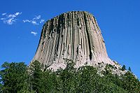
established the first national monument, Devils Tower
in Wyoming
, on September 24, 1906. He established eighteen national monuments, although only nine still retain that designation. Fifteen presidents have created national monuments since the program began; only Richard Nixon
and George H. W. Bush
did not. Bill Clinton
created the most monuments, nineteen, and expanded three others. Jimmy Carter
protected vast parts of Alaska
, proclaiming fifteen national monuments, some of which later were promoted to national park
s. The most recent national monument designated by Presidential Proclamation was by Barack Obama
on November 1, 2011 (Fort Monroe National Monument). Three marine locations in the central Pacific Ocean were protected, covering a total of 195274 square miles (505,757.3 km²). The most recent monument, Prehistoric Trackways
, was established by an Act of Congress, signed into law on March 30, 2009.
Twenty-seven states have national monuments, as do the District of Columbia, the Virgin Islands
, American Samoa
, the Minor Outlying Islands
, and the Northern Mariana Islands
. Arizona
, with eighteen, has the largest number of national monuments, followed by New Mexico
with twelve and California
with ten. Fifty-five national monuments protect places of natural significance, including ten geological sites, seven marine sites, and five volcanic sites. Twenty-two national monuments are associated with Native Americans. Twenty-four are other historical sites, including eleven forts.
Many national monuments are no longer designated as such. Some were changed to national parks or another status by Congress or the President, while others were transferred to state control or disbanded.
manage the 101 current U.S. national monuments. Of these, 96 monuments are managed by a single agency, while five are co-managed by two agencies. Only 75 of the NPS's 76 National Monuments are official units because Grand Canyon-Parashant National Monument
overlaps with Lake Mead National Recreation Area
.
Protected area
Protected areas are locations which receive protection because of their recognised natural, ecological and/or cultural values. There are several kinds of protected areas, which vary by level of protection depending on the enabling laws of each country or the regulations of the international...
s known as national monuments. The President of the United States
President of the United States
The President of the United States of America is the head of state and head of government of the United States. The president leads the executive branch of the federal government and is the commander-in-chief of the United States Armed Forces....
can establish a national monument by executive order, and the United States Congress
United States Congress
The United States Congress is the bicameral legislature of the federal government of the United States, consisting of the Senate and the House of Representatives. The Congress meets in the United States Capitol in Washington, D.C....
can by legislation. The Antiquities Act
Antiquities Act
The Antiquities Act of 1906, officially An Act for the Preservation of American Antiquities , is an act passed by the United States Congress and signed into law by Theodore Roosevelt on June 8, 1906, giving the President of the United States authority to, by executive order, restrict the use of...
of 1906 authorized the president to proclaim "historic landmarks, historic and prehistoric structures, and other objects of historic or scientific interest" as national monuments. Concerns about protecting mostly prehistoric Indian
Native Americans in the United States
Native Americans in the United States are the indigenous peoples in North America within the boundaries of the present-day continental United States, parts of Alaska, and the island state of Hawaii. They are composed of numerous, distinct tribes, states, and ethnic groups, many of which survive as...
ruins and artifacts—collectively termed antiquities
Antiquities
Antiquities, nearly always used in the plural in this sense, is a term for objects from Antiquity, especially the civilizations of the Mediterranean: the Classical antiquity of Greece and Rome, Ancient Egypt and the other Ancient Near Eastern cultures...
—on western federal lands prompted the legislation. Its purpose was to allow the president to quickly preserve public land without waiting for legislation to pass through an unconcerned Congress. The ultimate goal was to protect all historic and prehistoric sites on U.S. federal lands.
President Theodore Roosevelt
Theodore Roosevelt
Theodore "Teddy" Roosevelt was the 26th President of the United States . He is noted for his exuberant personality, range of interests and achievements, and his leadership of the Progressive Movement, as well as his "cowboy" persona and robust masculinity...
established the first national monument, Devils Tower
Devils Tower National Monument
Devils Tower is an igneous intrusion or laccolith located in the Black Hills near Hulett and Sundance in Crook County, northeastern Wyoming, above the Belle Fourche River...
in Wyoming
Wyoming
Wyoming is a state in the mountain region of the Western United States. The western two thirds of the state is covered mostly with the mountain ranges and rangelands in the foothills of the Eastern Rocky Mountains, while the eastern third of the state is high elevation prairie known as the High...
, on September 24, 1906. He established eighteen national monuments, although only nine still retain that designation. Fifteen presidents have created national monuments since the program began; only Richard Nixon
Richard Nixon
Richard Milhous Nixon was the 37th President of the United States, serving from 1969 to 1974. The only president to resign the office, Nixon had previously served as a US representative and senator from California and as the 36th Vice President of the United States from 1953 to 1961 under...
and George H. W. Bush
George H. W. Bush
George Herbert Walker Bush is an American politician who served as the 41st President of the United States . He had previously served as the 43rd Vice President of the United States , a congressman, an ambassador, and Director of Central Intelligence.Bush was born in Milton, Massachusetts, to...
did not. Bill Clinton
Bill Clinton
William Jefferson "Bill" Clinton is an American politician who served as the 42nd President of the United States from 1993 to 2001. Inaugurated at age 46, he was the third-youngest president. He took office at the end of the Cold War, and was the first president of the baby boomer generation...
created the most monuments, nineteen, and expanded three others. Jimmy Carter
Jimmy Carter
James Earl "Jimmy" Carter, Jr. is an American politician who served as the 39th President of the United States and was the recipient of the 2002 Nobel Peace Prize, the only U.S. President to have received the Prize after leaving office...
protected vast parts of Alaska
Alaska
Alaska is the largest state in the United States by area. It is situated in the northwest extremity of the North American continent, with Canada to the east, the Arctic Ocean to the north, and the Pacific Ocean to the west and south, with Russia further west across the Bering Strait...
, proclaiming fifteen national monuments, some of which later were promoted to national park
National park
A national park is a reserve of natural, semi-natural, or developed land that a sovereign state declares or owns. Although individual nations designate their own national parks differently A national park is a reserve of natural, semi-natural, or developed land that a sovereign state declares or...
s. The most recent national monument designated by Presidential Proclamation was by Barack Obama
Barack Obama
Barack Hussein Obama II is the 44th and current President of the United States. He is the first African American to hold the office. Obama previously served as a United States Senator from Illinois, from January 2005 until he resigned following his victory in the 2008 presidential election.Born in...
on November 1, 2011 (Fort Monroe National Monument). Three marine locations in the central Pacific Ocean were protected, covering a total of 195274 square miles (505,757.3 km²). The most recent monument, Prehistoric Trackways
Prehistoric Trackways National Monument
Prehistoric Trackways National Monument is the 100th national monument in The United States of America. The monument is located in the Robledo Mountains, near Las Cruces in the southern region of the U.S. state of New Mexico...
, was established by an Act of Congress, signed into law on March 30, 2009.
Twenty-seven states have national monuments, as do the District of Columbia, the Virgin Islands
United States Virgin Islands
The Virgin Islands of the United States are a group of islands in the Caribbean that are an insular area of the United States. The islands are geographically part of the Virgin Islands archipelago and are located in the Leeward Islands of the Lesser Antilles.The U.S...
, American Samoa
American Samoa
American Samoa is an unincorporated territory of the United States located in the South Pacific Ocean, southeast of the sovereign state of Samoa...
, the Minor Outlying Islands
United States Minor Outlying Islands
The United States Minor Outlying Islands, a statistical designation defined by the International Organization for Standardization's ISO 3166-1 code, consists of nine United States insular areas in the Pacific Ocean and Caribbean Sea: Baker Island, Howland Island, Jarvis Island, Johnston Atoll,...
, and the Northern Mariana Islands
Northern Mariana Islands
The Northern Mariana Islands, officially the Commonwealth of the Northern Mariana Islands , is a commonwealth in political union with the United States, occupying a strategic region of the western Pacific Ocean. It consists of 15 islands about three-quarters of the way from Hawaii to the Philippines...
. Arizona
Arizona
Arizona ; is a state located in the southwestern region of the United States. It is also part of the western United States and the mountain west. The capital and largest city is Phoenix...
, with eighteen, has the largest number of national monuments, followed by New Mexico
New Mexico
New Mexico is a state located in the southwest and western regions of the United States. New Mexico is also usually considered one of the Mountain States. With a population density of 16 per square mile, New Mexico is the sixth-most sparsely inhabited U.S...
with twelve and California
California
California is a state located on the West Coast of the United States. It is by far the most populous U.S. state, and the third-largest by land area...
with ten. Fifty-five national monuments protect places of natural significance, including ten geological sites, seven marine sites, and five volcanic sites. Twenty-two national monuments are associated with Native Americans. Twenty-four are other historical sites, including eleven forts.
Many national monuments are no longer designated as such. Some were changed to national parks or another status by Congress or the President, while others were transferred to state control or disbanded.
Breakdown by federal agency and department
Six federal agencies in four departmentsUnited States Federal Executive Departments
The United States federal executive departments are among the oldest primary units of the executive branch of the federal government of the United States—the Departments of State, War, and the Treasury all being established within a few weeks of each other in 1789.Federal executive...
manage the 101 current U.S. national monuments. Of these, 96 monuments are managed by a single agency, while five are co-managed by two agencies. Only 75 of the NPS's 76 National Monuments are official units because Grand Canyon-Parashant National Monument
Grand Canyon-Parashant National Monument
Grand Canyon-Parashant National Monument is located on the northern edge of the Grand Canyon in northwest Arizona. It was established by Presidential Proclamation 7265 on January 11, 2000...
overlaps with Lake Mead National Recreation Area
Lake Mead National Recreation Area
Lake Mead National Recreation Area is located in southern Nevada and northwestern Arizona. The centerpieces of the National Recreation Area are its two large reservoirs: Lake Mead and Lake Mohave. These lakes cater to boaters, swimmers, sunbathers, and fishermen while the surrounding desert rewards...
.
| Agency | Department | Co-managed | Total managed |
|---|---|---|---|
| National Park Service National Park Service The National Park Service is the U.S. federal agency that manages all national parks, many national monuments, and other conservation and historical properties with various title designations... (NPS) |
Interior | 2 with BLM, 1 with FWS | 76 |
| Bureau of Land Management Bureau of Land Management The Bureau of Land Management is an agency within the United States Department of the Interior which administers America's public lands, totaling approximately , or one-eighth of the landmass of the country. The BLM also manages of subsurface mineral estate underlying federal, state and private... (BLM) |
Interior | 2 with NPS, 1 with USFS | 16 |
| United States Forest Service United States Forest Service The United States Forest Service is an agency of the United States Department of Agriculture that administers the nation's 155 national forests and 20 national grasslands, which encompass... (USFS) |
Agriculture United States Department of Agriculture The United States Department of Agriculture is the United States federal executive department responsible for developing and executing U.S. federal government policy on farming, agriculture, and food... |
1 with BLM | 6 |
| Fish and Wildlife Service (FWS) | Interior | 1 with NOAA, 1 with NPS | 6 |
| Armed Forces Retirement Home Armed Forces Retirement Home The Armed Forces Retirement Home , formerly the U.S. Soldiers' and Airmen's Home, the U.S. Soldiers' Home, and the U.S. Military Asylum, is an independent establishment in the executive branch of the federal government of the United States... (AFRH) |
Defense United States Department of Defense The United States Department of Defense is the U.S... |
— | 1 |
| National Oceanic and Atmospheric Administration National Oceanic and Atmospheric Administration The National Oceanic and Atmospheric Administration , pronounced , like "noah", is a scientific agency within the United States Department of Commerce focused on the conditions of the oceans and the atmosphere... (NOAA) |
Commerce | 1 with FWS | 1 |
| (duplications) | (5) | ||
| Total | 101 | ||
National Monuments
| National Monument Name | Photo | Agency | Location | Date Established | Description |
|---|---|---|---|---|---|
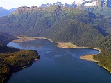
| Admiralty Island Admiralty Island National Monument Admiralty Island National Monument is located on Admiralty Island in Southeast Alaska. It was created December 1, 1978, and covers 955,747 acres of Tongass National Forest in the Panhandle of southeast Alaska... |
 |
USFS | Alaska Alaska Alaska is the largest state in the United States by area. It is situated in the northwest extremity of the North American continent, with Canada to the east, the Arctic Ocean to the north, and the Pacific Ocean to the west and south, with Russia further west across the Bering Strait... 57.64°N 134.35°W |
Occupying most of Admiralty Island Admiralty Island Admiralty Island is an island in the Alexander Archipelago in Southeast Alaska, at . It is 145 km long and 56 km wide with an area of 4,264.1 km² , making it the seventh largest island in the United States and the 132nd largest island in the world. It is one of the... , the 7th largest in the United States, this monument is part of Tongass National Forest Tongass National Forest The Tongass National Forest in southeastern Alaska is the largest national forest in the United States at 17 million acres . Most of its area is part of the temperate rain forest WWF ecoregion, itself part of the larger Pacific temperate rain forest WWF ecoregion, and is remote enough to be home... in the Alaska Panhandle Alaska Panhandle Southeast Alaska, sometimes referred to as the Alaska Panhandle, is the southeastern portion of the U.S. state of Alaska, which lies west of the northern half of the Canadian province of British Columbia. The majority of Southeast Alaska's area is part of the Tongass National Forest, the United... . It has a large population of grizzly Grizzly Bear The grizzly bear , also known as the silvertip bear, the grizzly, or the North American brown bear, is a subspecies of brown bear that generally lives in the uplands of western North America... , black American black bear The American black bear is a medium-sized bear native to North America. It is the continent's smallest and most common bear species. Black bears are omnivores, with their diets varying greatly depending on season and location. They typically live in largely forested areas, but do leave forests in... , and brown bear Brown Bear The brown bear is a large bear distributed across much of northern Eurasia and North America. It can weigh from and its largest subspecies, the Kodiak Bear, rivals the polar bear as the largest member of the bear family and as the largest land-based predator.There are several recognized... s, as well as whale Whale Whale is the common name for various marine mammals of the order Cetacea. The term whale sometimes refers to all cetaceans, but more often it excludes dolphins and porpoises, which belong to suborder Odontoceti . This suborder also includes the sperm whale, killer whale, pilot whale, and beluga... s, mountain goat Mountain goat The Mountain Goat , also known as the Rocky Mountain Goat, is a large-hoofed mammal found only in North America. Despite its vernacular name, it is not a member of Capra, the genus of true goats... s, and deer Deer Deer are the ruminant mammals forming the family Cervidae. Species in the Cervidae family include white-tailed deer, elk, moose, red deer, reindeer, fallow deer, roe deer and chital. Male deer of all species and female reindeer grow and shed new antlers each year... . Most of the monument has been declared the Kootznoowoo Wilderness, restricting future development. The Greens Creek mine lies within the monument. |
|
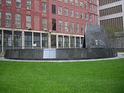
| African Burial Ground African Burial Ground National Monument African Burial Ground National Monument at Duane Street and African Burial Ground Way in Lower Manhattan preserves a site containing the remains of more than 400 Africans buried during the 17th and 18th centuries. Historians estimate there may have been 15,000-20,000 burials there... |
 |
NPS National Park Service The National Park Service is the U.S. federal agency that manages all national parks, many national monuments, and other conservation and historical properties with various title designations... |
New York New York New York is a state in the Northeastern region of the United States. It is the nation's third most populous state. New York is bordered by New Jersey and Pennsylvania to the south, and by Connecticut, Massachusetts and Vermont to the east... 40.7144°N 74.0042°W |
Re-discovered in 1991 during excavations for a new federal building, this former burial ground that contains the remains of more than 400 free and enslaved Africans buried during the 17th and 18th centuries was designated a National Historic Landmark National Historic Landmark A National Historic Landmark is a building, site, structure, object, or district, that is officially recognized by the United States government for its historical significance... memorial in 1993. |
|
| Agate Fossil Beds Agate Fossil Beds National Monument Agate Fossil Beds National Monument is a U.S. National Monument near Harrison, Nebraska. The main features of the Monument are a valley of the Niobrara River, and the fossils found on Carnegie Hill and University Hill.... |
 |
NPS National Park Service The National Park Service is the U.S. federal agency that manages all national parks, many national monuments, and other conservation and historical properties with various title designations... |
Nebraska Nebraska Nebraska is a state on the Great Plains of the Midwestern United States. The state's capital is Lincoln and its largest city is Omaha, on the Missouri River.... 42.416°N 103.728°W |
The valley of the Niobrara River Niobrara River The Niobrara River is a tributary of the Missouri River, approximately long, running through the U.S. states of Wyoming and Nebraska. The river drains one of the most arid sections of the Great Plains, and has a low flow for a river of its length... is known for its large number of well-preserved Miocene Miocene The Miocene is a geological epoch of the Neogene Period and extends from about . The Miocene was named by Sir Charles Lyell. Its name comes from the Greek words and and means "less recent" because it has 18% fewer modern sea invertebrates than the Pliocene. The Miocene follows the Oligocene... mammal fossil Fossil Fossils are the preserved remains or traces of animals , plants, and other organisms from the remote past... s which date from about 20 million years ago. |
|
| Agua Fria Agua Fria National Monument Agua Fria National Monument is located in the U.S. state of Arizona, approximately 40 miles north of downtown Phoenix, Arizona. Created by Presidential proclamation on January 11, 2000, the 71,100 acre monument is managed by the U.S. Bureau of Land Management, an agency within the U.S.... |
 |
BLM Bureau of Land Management The Bureau of Land Management is an agency within the United States Department of the Interior which administers America's public lands, totaling approximately , or one-eighth of the landmass of the country. The BLM also manages of subsurface mineral estate underlying federal, state and private... |
Arizona Arizona Arizona ; is a state located in the southwestern region of the United States. It is also part of the western United States and the mountain west. The capital and largest city is Phoenix... 34.15°N 112.08°W |
Located around the canyon of the Agua Fria River, it contains more than 450 distinct Native American Native Americans in the United States Native Americans in the United States are the indigenous peoples in North America within the boundaries of the present-day continental United States, parts of Alaska, and the island state of Hawaii. They are composed of numerous, distinct tribes, states, and ethnic groups, many of which survive as... structures, including large pueblo Pueblo Pueblo is a term used to describe modern communities of Native Americans in the Southwestern United States of America. The first Spanish explorers of the Southwest used this term to describe the communities housed in apartment-like structures built of stone, adobe mud, and other local material... s with more than 100 rooms. |
|
| Alibates Flint Quarries Alibates Flint Quarries National Monument Alibates Flint Quarries National Monument is a U.S. National Monument in the State of Texas. For thousands of years, people came to the red bluffs above the Canadian River for flint, vital to their existence. Demand for the high quality, rainbow-hued flint is reflected in the distribution of... |
 |
NPS National Park Service The National Park Service is the U.S. federal agency that manages all national parks, many national monuments, and other conservation and historical properties with various title designations... |
Texas Texas Texas is the second largest U.S. state by both area and population, and the largest state by area in the contiguous United States.The name, based on the Caddo word "Tejas" meaning "friends" or "allies", was applied by the Spanish to the Caddo themselves and to the region of their settlement in... 35.57°N 101.67°W |
Alibates was the quarry site for high-quality, rainbow-hued flint Flint Flint is a hard, sedimentary cryptocrystalline form of the mineral quartz, categorized as a variety of chert. It occurs chiefly as nodules and masses in sedimentary rocks, such as chalks and limestones. Inside the nodule, flint is usually dark grey, black, green, white, or brown in colour, and... that was distributed throughout the Great Plains Great Plains The Great Plains are a broad expanse of flat land, much of it covered in prairie, steppe and grassland, which lies west of the Mississippi River and east of the Rocky Mountains in the United States and Canada. This area covers parts of the U.S... in pre-Columbian Pre-Columbian The pre-Columbian era incorporates all period subdivisions in the history and prehistory of the Americas before the appearance of significant European influences on the American continents, spanning the time of the original settlement in the Upper Paleolithic period to European colonization during... times. It is part of the Lake Meredith National Recreation Area Lake Meredith National Recreation Area Lake Meredith National Recreation Area is a United States National Recreation Area located about north of Amarillo, Texas, in the Texas Panhandle. The main attraction of the recreation area is Lake Meredith, an artificial reservoir created by Sanford Dam on the Canadian River.Activities at Lake... and includes the ruins of several Plains Village Indian dwellings. |
|
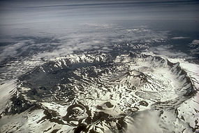
| Aniakchak Aniakchak National Monument and Preserve Aniakchak National Monument and Preserve is a U.S. National Monument and National Preserve, consisting of the region around the Aniakchak volcano on the Aleutian Range of south-western Alaska.... |
 |
NPS National Park Service The National Park Service is the U.S. federal agency that manages all national parks, many national monuments, and other conservation and historical properties with various title designations... |
Alaska Alaska Alaska is the largest state in the United States by area. It is situated in the northwest extremity of the North American continent, with Canada to the east, the Arctic Ocean to the north, and the Pacific Ocean to the west and south, with Russia further west across the Bering Strait... 56.9°N 158.15°W |
Mount Aniakchak Mount Aniakchak Mount Aniakchak is a 3,700 year old volcanic caldera located in the Aleutian Range of Alaska, United States. The area around the volcano is the Aniakchak National Monument and Preserve, maintained by the National Park Service... , which erupted 3,500 years ago, and the surrounding region make up one of the least visited NPS National Park Service The National Park Service is the U.S. federal agency that manages all national parks, many national monuments, and other conservation and historical properties with various title designations... sites. Surprise Lake, within the volcano's 6 miles (9.7 km) wide, 2500 feet (762 m) deep caldera Caldera A caldera is a cauldron-like volcanic feature usually formed by the collapse of land following a volcanic eruption, such as the one at Yellowstone National Park in the US. They are sometimes confused with volcanic craters... , is the source of the Aniakchak River Aniakchak River The Aniakchak River is a river in Lake and Peninsula Borough on the Alaska Peninsula. It arises in Surprise Lake in the Aniakchak National Monument and Preserve and flows eastward into Aniakchak Bay and the Pacific Ocean.... . |
|
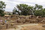
| Aztec Ruins Aztec Ruins National Monument The Aztec Ruins National Monument preserves ancestral Pueblo structures in north-western New Mexico, United States, located close to the town of Aztec and northeast of Farmington, near the Animas River... |
 |
NPS National Park Service The National Park Service is the U.S. federal agency that manages all national parks, many national monuments, and other conservation and historical properties with various title designations... |
New Mexico New Mexico New Mexico is a state located in the southwest and western regions of the United States. New Mexico is also usually considered one of the Mountain States. With a population density of 16 per square mile, New Mexico is the sixth-most sparsely inhabited U.S... 36.83°N 107.00°W |
The ruins contain Pueblo structures from the 11th to 13th centuries with more than 400 masonry rooms which were misidentified by early American settlers as Aztec Aztec The Aztec people were certain ethnic groups of central Mexico, particularly those groups who spoke the Nahuatl language and who dominated large parts of Mesoamerica in the 14th, 15th and 16th centuries, a period referred to as the late post-classic period in Mesoamerican chronology.Aztec is the... . It lies within the World Heritage Site World Heritage Site A UNESCO World Heritage Site is a place that is listed by the UNESCO as of special cultural or physical significance... of Chaco Culture National Historical Park Chaco Culture National Historical Park Chaco Culture National Historical Park is a United States National Historical Park hosting the densest and most exceptional concentration of pueblos in the American Southwest. The park is located in northwestern New Mexico, between Albuquerque and Farmington, in a remote canyon cut by the Chaco Wash... . |
|
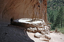
| Bandelier Bandelier National Monument Bandelier National Monument is a National Monument preserving the homes of the Ancestral Pueblo People. It is named after Swiss anthropologist Adolph Bandelier, who researched the cultures of the area. Bandelier was designated a National Monument on February 11, 1916, and most of its backcountry... |
 |
NPS National Park Service The National Park Service is the U.S. federal agency that manages all national parks, many national monuments, and other conservation and historical properties with various title designations... |
New Mexico New Mexico New Mexico is a state located in the southwest and western regions of the United States. New Mexico is also usually considered one of the Mountain States. With a population density of 16 per square mile, New Mexico is the sixth-most sparsely inhabited U.S... 35.78°N 106.27°W |
A historic district Historic district (United States) In the United States, a historic district is a group of buildings, properties, or sites that have been designated by one of several entities on different levels as historically or architecturally significant. Buildings, structures, objects and sites within a historic district are normally divided... , Bandelier contains Frijoles Canyon, which contains Ancestral Pueblo homes, kiva Kiva A kiva is a room used by modern Puebloans for religious rituals, many of them associated with the kachina belief system. Among the modern Hopi and most other Pueblo peoples, kivas are square-walled and underground, and are used for spiritual ceremonies.... s, rock paintings and petroglyph Petroglyph Petroglyphs are pictogram and logogram images created by removing part of a rock surface by incising, picking, carving, and abrading. Outside North America, scholars often use terms such as "carving", "engraving", or other descriptions of the technique to refer to such images... s. |
|
| Booker T. Washington Booker T. Washington National Monument The Booker T. Washington National Monument is a National Monument near Hardy, Franklin County, Virginia. It preserves portions of the 207-acre tobacco farm on which educator and leader Booker T. Washington was born into slavery on April 5, 1856... |
 |
NPS National Park Service The National Park Service is the U.S. federal agency that manages all national parks, many national monuments, and other conservation and historical properties with various title designations... |
Virginia Virginia The Commonwealth of Virginia , is a U.S. state on the Atlantic Coast of the Southern United States. Virginia is nicknamed the "Old Dominion" and sometimes the "Mother of Presidents" after the eight U.S. presidents born there... 37.123°N 79.766°W |
The Booker T. Washington National Monument preserves portions of the 207 acre (0.83770002 km²) tobacco Tobacco Tobacco is an agricultural product processed from the leaves of plants in the genus Nicotiana. It can be consumed, used as a pesticide and, in the form of nicotine tartrate, used in some medicines... farm on which educator and civil rights leader Booker T. Washington Booker T. Washington Booker Taliaferro Washington was an American educator, author, orator, and political leader. He was the dominant figure in the African-American community in the United States from 1890 to 1915... was born into slavery on April 5, 1856. The site contains replicas of the house Washington was born in, a smokehouse, a blacksmith shed, a tobacco barn, and a horse barn. |
|
| Buck Island Reef Buck Island Reef National Monument Buck Island Reef National Monument, or just Chicken Island is a small, pink, 5 foot island about 1.5 miles north of the northeast coast of Saint Croix, U.S. Virgin Islands. It was first established as a protected area by the U.S. Government in 1948, with the intention of preserving “one of the... |
 |
NPS National Park Service The National Park Service is the U.S. federal agency that manages all national parks, many national monuments, and other conservation and historical properties with various title designations... |
Virgin Islands United States Virgin Islands The Virgin Islands of the United States are a group of islands in the Caribbean that are an insular area of the United States. The islands are geographically part of the Virgin Islands archipelago and are located in the Leeward Islands of the Lesser Antilles.The U.S... 17.79°N 64.62°W |
Most of this 19000 acres (76.9 km²) monument is underwater, containing a large elkhorn coral barrier reef Coral reef Coral reefs are underwater structures made from calcium carbonate secreted by corals. Coral reefs are colonies of tiny living animals found in marine waters that contain few nutrients. Most coral reefs are built from stony corals, which in turn consist of polyps that cluster in groups. The polyps... that provides cover for a great variety of reef fish, sea turtle Sea turtle Sea turtles are marine reptiles that inhabit all of the world's oceans except the Arctic.-Distribution:... s and Least Terns. It is based around Buck Island, an uninhabited 176 acre (0.71224736 km²) island. |
|
| Cabrillo Cabrillo National Monument Cabrillo National Monument is located at the southern tip of the Point Loma Peninsula in San Diego, California. It commemorates the landing of Juan Rodríguez Cabrillo at San Diego Bay on September 28, 1542. This event marked the first time that a European expedition had set foot on what later... |
 |
NPS National Park Service The National Park Service is the U.S. federal agency that manages all national parks, many national monuments, and other conservation and historical properties with various title designations... |
California California California is a state located on the West Coast of the United States. It is by far the most populous U.S. state, and the third-largest by land area... 32.67°N 117.24°W |
This monument commemorates the landing of Juan Rodríguez Cabrillo Juan Rodríguez Cabrillo Juan Rodriguez Cabrillo was a Portuguese explorer noted for his exploration of the west coast of North America on behalf of Spain. Cabrillo was the first European explorer to navigate the coast of present day California in the United States... at San Diego Bay San Diego Bay San Diego Bay is a natural harbor and deepwater port adjacent to San Diego, California. It is 12 mi/19 km long, 1 mi/1.6 km–3 mi/4.8 km wide... on September 28, 1542, which was the first European expedition on what later became the west coast of the U.S. The monument includes a statue of Cabrillo and 16th-century coastal artillery Coastal artillery Coastal artillery is the branch of armed forces concerned with operating anti-ship artillery or fixed gun batteries in coastal fortifications.... batteries built to protect the harbor of San Diego from enemy warships. |
|
| California Coastal California Coastal National Monument The California Coastal National Monument is located along the entire coastline of the U.S. state of California. Created by Presidential proclamation on January 11, 2000, the monument, which covers about of land, is managed by the U.S. Bureau of Land Management, an agency of the U.S. Department... |
 |
BLM Bureau of Land Management The Bureau of Land Management is an agency within the United States Department of the Interior which administers America's public lands, totaling approximately , or one-eighth of the landmass of the country. The BLM also manages of subsurface mineral estate underlying federal, state and private... |
California California California is a state located on the West Coast of the United States. It is by far the most populous U.S. state, and the third-largest by land area... 36.89°N 122.18°W |
This monument ensures the protection of all islets, reefs and rock outcroppings from the coast of California California California is a state located on the West Coast of the United States. It is by far the most populous U.S. state, and the third-largest by land area... to a distance of 12 nautical miles (22.2 km), along the entire 840 miles (1,351.8 km) long California coastline. |
|
| Canyon de Chelly Canyon de Chelly National Monument Canyon de Chelly National Monument was established on April 1, 1931 as a unit of the National Park Service. It is located in northeastern Arizona within the boundaries of the Navajo Nation... |
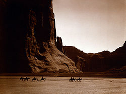 |
NPS National Park Service The National Park Service is the U.S. federal agency that manages all national parks, many national monuments, and other conservation and historical properties with various title designations... |
Arizona Arizona Arizona ; is a state located in the southwestern region of the United States. It is also part of the western United States and the mountain west. The capital and largest city is Phoenix... 36.13°N 109.47°W |
Located within the boundaries of the Navajo Nation Navajo Nation The Navajo Nation is a semi-autonomous Native American-governed territory covering , occupying all of northeastern Arizona, the southeastern portion of Utah, and northwestern New Mexico... , it preserves the valleys and rims of the canyons of de Chelly, del Muerto, and Monument, all of which are Navajo Tribal Trust Lands. |
|
| Canyons of the Ancients Canyons of the Ancients National Monument Canyons of the Ancients National Monument is located in the southwestern region of the U.S. state of Colorado, and is managed by the U.S. Bureau of Land Management, an agency within the U.S. Department of the Interior... |
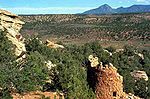 |
BLM Bureau of Land Management The Bureau of Land Management is an agency within the United States Department of the Interior which administers America's public lands, totaling approximately , or one-eighth of the landmass of the country. The BLM also manages of subsurface mineral estate underlying federal, state and private... |
Colorado Colorado Colorado is a U.S. state that encompasses much of the Rocky Mountains as well as the northeastern portion of the Colorado Plateau and the western edge of the Great Plains... 37.37°N 109°W |
Surrounding Hovenweep National Monument Hovenweep National Monument Hovenweep National Monument is located on land in southwestern Colorado and southeastern Utah, located between Cortez, Colorado and Blanding, Utah on the Cajon Mesa of the Great Sage Plain... , it preserves and protects more than 6,000 archeological Archaeology Archaeology, or archeology , is the study of human society, primarily through the recovery and analysis of the material culture and environmental data that they have left behind, which includes artifacts, architecture, biofacts and cultural landscapes... sites, the largest concentration in the U.S. |
|
| Cape Krusenstern Cape Krusenstern National Monument Cape Krusenstern National Monument and the colocated Cape Krusenstern Archeological District is a U.S. National Monument and a National Historic Landmark centered on Cape Krusenstern in northwestern Alaska.... |
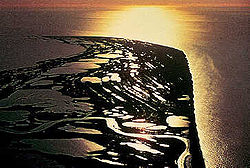 |
NPS National Park Service The National Park Service is the U.S. federal agency that manages all national parks, many national monuments, and other conservation and historical properties with various title designations... |
Alaska Alaska Alaska is the largest state in the United States by area. It is situated in the northwest extremity of the North American continent, with Canada to the east, the Arctic Ocean to the north, and the Pacific Ocean to the west and south, with Russia further west across the Bering Strait... 67.41°N 163.50°W |
Co-located with the NHLD Cape Krusenstern Archeological District, this coastal plain contains large lagoons and rolling hills of limestone Limestone Limestone is a sedimentary rock composed largely of the minerals calcite and aragonite, which are different crystal forms of calcium carbonate . Many limestones are composed from skeletal fragments of marine organisms such as coral or foraminifera.... . The bluffs record thousands of years of change in the shorelines of the Chukchi Sea Chukchi Sea Chukchi Sea is a marginal sea of the Arctic Ocean. It is bounded on the west by the De Long Strait, off Wrangel Island, and in the east by Point Barrow, Alaska, beyond which lies the Beaufort Sea. The Bering Strait forms its southernmost limit and connects it to the Bering Sea and the Pacific... , as well as evidence of some 9,000 years of human habitation. |
|
| Capulin Volcano Capulin Volcano National Monument Capulin Volcano National Monument, located in northeastern New Mexico, was designated a U.S. National Monument on August 9, 1916. It is an example of an extinct cinder cone volcano that is part of the Raton-Clayton Volcanic Field. A paved road spirals around the volcano and visitors can drive up... |
NPS National Park Service The National Park Service is the U.S. federal agency that manages all national parks, many national monuments, and other conservation and historical properties with various title designations... |
New Mexico New Mexico New Mexico is a state located in the southwest and western regions of the United States. New Mexico is also usually considered one of the Mountain States. With a population density of 16 per square mile, New Mexico is the sixth-most sparsely inhabited U.S... 36.79°N 103.96°W |
Capulin is an extinct cinder cone volcano Volcano 2. Bedrock3. Conduit 4. Base5. Sill6. Dike7. Layers of ash emitted by the volcano8. Flank| 9. Layers of lava emitted by the volcano10. Throat11. Parasitic cone12. Lava flow13. Vent14. Crater15... that is approximately 59,000 years old and part of the Raton-Clayton Volcanic Field Raton-Clayton volcanic field Raton-Clayton volcanic field is an extinct volcanic field located in the state of New Mexico, United States. Capulin Volcano National Monument is located in the volcanic field. It is thought to have been formed by the Raton hotspot.-Notable Vents:... . The crater is 400 feet (121.9 m) deep and its rim is more than 1500 feet (457.2 m) in diameter. |
||
| Carrizo Plain Carrizo Plain The Carrizo Plain is a large enclosed plain, approximately 50 miles long and up to 15 miles across, in southeastern San Luis Obispo County, California, about 100 miles northwest of Los Angeles, California... |
 |
BLM Bureau of Land Management The Bureau of Land Management is an agency within the United States Department of the Interior which administers America's public lands, totaling approximately , or one-eighth of the landmass of the country. The BLM also manages of subsurface mineral estate underlying federal, state and private... |
California California California is a state located on the West Coast of the United States. It is by far the most populous U.S. state, and the third-largest by land area... 35.16°N 119.75°W |
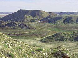
Carrizo Plain is the largest single native Indigenous (ecology) In biogeography, a species is defined as native to a given region or ecosystem if its presence in that region is the result of only natural processes, with no human intervention. Every natural organism has its own natural range of distribution in which it is regarded as native... grassland Grassland Grasslands are areas where the vegetation is dominated by grasses and other herbaceous plants . However, sedge and rush families can also be found. Grasslands occur naturally on all continents except Antarctica... remaining in California. It contains part of the San Andreas Fault San Andreas Fault The San Andreas Fault is a continental strike-slip fault that runs a length of roughly through California in the United States. The fault's motion is right-lateral strike-slip... and is surrounded by the Temblor Range Temblor Range The Temblor Range is a mountain range within the California Coast Ranges, at the southwestern extremity of the San Joaquin Valley in California in the United States. It runs in a northwest-southeasterly direction along the borders of Kern County and San Luis Obispo County. The name of the range is... and the Caliente Range Caliente Range The Caliente Range is a west-east trending zone of uplift mountains in the Pacific Coast Ranges, in central California. They are home to 5106 foot Caliente Mountain, the highest peak in San Luis Obispo County, California.-Geologic setting:... . At the center of the plain is Soda Lake Soda Lake (San Luis Obispo County) Soda Lake is a shallow, ephemeral, alkali endorheic lake in the Carrizo Plain in southeastern San Luis Obispo County, California. The lake is located on the southwest side of the northern Carrizo Plain, 103 km east of San Luis Obispo. It can be reached by Soda Lake Road, which runs... , which is near Painted Rock Painted Rock Painted Rock is a smooth horseshoe-shaped marine sandstone rock formation with pictograph rock art about 250 feet across and 45 feet tall near Soda Lake within the Carrizo Plain National Monument on the southwest side of the northern Carrizo Plain, west of Bakersfield, California and about east... . |
|
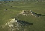
| Casa Grande Ruins Casa Grande Ruins National Monument Casa Grande Ruins National Monument, in Coolidge, Arizona, just northeast of the city of Casa Grande, preserves a group of Ancient Pueblo Peoples Hohokam structures of the Pueblo III and Pueblo IV Eras.-Ancient pueblos:... |
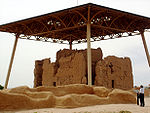 |
NPS National Park Service The National Park Service is the U.S. federal agency that manages all national parks, many national monuments, and other conservation and historical properties with various title designations... |
Arizona Arizona Arizona ; is a state located in the southwestern region of the United States. It is also part of the western United States and the mountain west. The capital and largest city is Phoenix... 32.99°N 111.54°W |
This monument preserves a group of structures surrounded by a compound wall in the Gila Valley Gila River The Gila River is a tributary of the Colorado River, 650 miles long, in the southwestern states of New Mexico and Arizona.-Description:... that were built in the early 13th century. They were inhabited by the Hohokam Hohokam Hohokam is one of the four major prehistoric archaeological Oasisamerica traditions of what is now the American Southwest. Many local residents put the accent on the first syllable . Variant spellings in current, official usage include Hobokam, Huhugam and Huhukam... people until they were abandoned in the mid-15th century. |
|
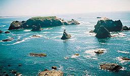
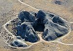
| Cascade–Siskiyou |  |
BLM Bureau of Land Management The Bureau of Land Management is an agency within the United States Department of the Interior which administers America's public lands, totaling approximately , or one-eighth of the landmass of the country. The BLM also manages of subsurface mineral estate underlying federal, state and private... |
Oregon Oregon Oregon is a state in the Pacific Northwest region of the United States. It is located on the Pacific coast, with Washington to the north, California to the south, Nevada on the southeast and Idaho to the east. The Columbia and Snake rivers delineate much of Oregon's northern and eastern... 42.08°N 122.46°W |
One of the most diverse ecosystem Ecosystem An ecosystem is a biological environment consisting of all the organisms living in a particular area, as well as all the nonliving , physical components of the environment with which the organisms interact, such as air, soil, water and sunlight.... s found in the Cascade Range Cascade Range The Cascade Range is a major mountain range of western North America, extending from southern British Columbia through Washington and Oregon to Northern California. It includes both non-volcanic mountains, such as the North Cascades, and the notable volcanoes known as the High Cascades... , it has more than 100 dwelling and root-gathering sites belonging to the Modoc, Klamath, and Shasta Shasta (tribe) The Shasta are an indigenous people of Northern California and Southern Oregon in the United States. They spoke one of the Shastan languages.... tribes. |
|
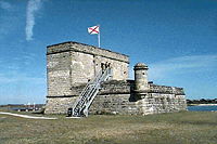
| Castillo de San Marcos Castillo de San Marcos The Castillo de San Marcos site is the oldest masonry fort in the United States. It is located in the city of St. Augustine, Florida. Construction was begun in 1672 by the Spanish when Florida was a Spanish territory. During the twenty year period of British possession from 1763 until 1784, the... |
 |
NPS National Park Service The National Park Service is the U.S. federal agency that manages all national parks, many national monuments, and other conservation and historical properties with various title designations... |
Florida Florida Florida is a state in the southeastern United States, located on the nation's Atlantic and Gulf coasts. It is bordered to the west by the Gulf of Mexico, to the north by Alabama and Georgia and to the east by the Atlantic Ocean. With a population of 18,801,310 as measured by the 2010 census, it... 29.898°N 81.311°W |
This Spanish fort near St. Augustine St. Augustine, Florida St. Augustine is a city in the northeast section of Florida and the county seat of St. Johns County, Florida, United States. Founded in 1565 by Spanish explorer and admiral Pedro Menéndez de Avilés, it is the oldest continuously occupied European-established city and port in the continental United... , called Fort Marion when first protected, served for 205 years under four different flags. Built in 1672, it was involved in sieges with the British while under Spanish command, the American Revolution American Revolution The American Revolution was the political upheaval during the last half of the 18th century in which thirteen colonies in North America joined together to break free from the British Empire, combining to become the United States of America... under Britain, the Civil War American Civil War The American Civil War was a civil war fought in the United States of America. In response to the election of Abraham Lincoln as President of the United States, 11 southern slave states declared their secession from the United States and formed the Confederate States of America ; the other 25... under the Confederacy Confederate States of America The Confederate States of America was a government set up from 1861 to 1865 by 11 Southern slave states of the United States of America that had declared their secession from the U.S... , and the Seminole Wars Seminole Wars The Seminole Wars, also known as the Florida Wars, were three conflicts in Florida between the Seminole — the collective name given to the amalgamation of various groups of native Americans and Black people who settled in Florida in the early 18th century — and the United States Army... and the Spanish-American War Spanish-American War The Spanish–American War was a conflict in 1898 between Spain and the United States, effectively the result of American intervention in the ongoing Cuban War of Independence... under the United States. |
|
| Castle Clinton Castle Clinton Castle Clinton or Fort Clinton, once known as Castle Garden, is a circular sandstone fort now located in Battery Park at the southern tip of Manhattan Island, New York City, in the United States. It is perhaps best remembered as America's first immigration station , where more than 8 million... |
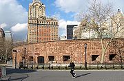 |
NPS National Park Service The National Park Service is the U.S. federal agency that manages all national parks, many national monuments, and other conservation and historical properties with various title designations... |
New York New York New York is a state in the Northeastern region of the United States. It is the nation's third most populous state. New York is bordered by New Jersey and Pennsylvania to the south, and by Connecticut, Massachusetts and Vermont to the east... 40.7036°N 74.0169°W |
A circular sandstone fort built in 1811 at the southern tip of Manhattan Manhattan Manhattan is the oldest and the most densely populated of the five boroughs of New York City. Located primarily on the island of Manhattan at the mouth of the Hudson River, the boundaries of the borough are identical to those of New York County, an original county of the state of New York... to protect New York City New York City New York is the most populous city in the United States and the center of the New York Metropolitan Area, one of the most populous metropolitan areas in the world. New York exerts a significant impact upon global commerce, finance, media, art, fashion, research, technology, education, and... from the British, Castle Clinton is now located in Battery Park. It later became a beer garden Beer garden Beer garden is an open-air area where beer, other drinks and local food are served. The concept originates from and is most common in Southern Germany... , a theater, the first immigration station (predating Ellis Island Ellis Island Ellis Island in New York Harbor was the gateway for millions of immigrants to the United States. It was the nation's busiest immigrant inspection station from 1892 until 1954. The island was greatly expanded with landfill between 1892 and 1934. Before that, the much smaller original island was the... ), and a public aquarium Aquarium An aquarium is a vivarium consisting of at least one transparent side in which water-dwelling plants or animals are kept. Fishkeepers use aquaria to keep fish, invertebrates, amphibians, marine mammals, turtles, and aquatic plants... . |
|
| Cedar Breaks Cedar Breaks National Monument Cedar Breaks National Monument is a U.S. National Monument located in the U.S. state of Utah near Cedar City. Cedar Breaks is a natural amphitheater canyon, stretching across , with a depth of over . The elevation of the rim of the canyon is over above sea level.The eroded rock of the canyon is... |
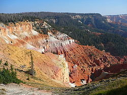 |
NPS National Park Service The National Park Service is the U.S. federal agency that manages all national parks, many national monuments, and other conservation and historical properties with various title designations... |
Utah Utah Utah is a state in the Western United States. It was the 45th state to join the Union, on January 4, 1896. Approximately 80% of Utah's 2,763,885 people live along the Wasatch Front, centering on Salt Lake City. This leaves vast expanses of the state nearly uninhabited, making the population the... 37.63°N 112.85°W |
A natural amphitheater canyon similar to formations at Bryce Canyon National Park Bryce Canyon National Park Bryce Canyon National Park is a national park located in southwestern Utah in the United States. The major feature of the park is Bryce Canyon which, despite its name, is not a canyon but a giant natural amphitheater created by erosion along the eastern side of the Paunsaugunt Plateau... , it stretches over 3 miles (4.8 km) and is more than 2000 feet (609.6 m) deep. |
|
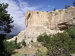
| Chiricahua Chiricahua National Monument Chiricahua National Monument is a unit of the National Park Service located in the Chiricahua Mountains. It is famous for its extensive vertical rock formations. The monument is located approximately southeast of Willcox, Arizona. It preserves the remains of an immense volcanic eruption that... |
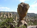 |
NPS National Park Service The National Park Service is the U.S. federal agency that manages all national parks, many national monuments, and other conservation and historical properties with various title designations... |
Arizona Arizona Arizona ; is a state located in the southwestern region of the United States. It is also part of the western United States and the mountain west. The capital and largest city is Phoenix... 32.02°N 109.35°W |
These Rhyolite tuffs are the eroded remains of an immense volcanic eruption that shook the region some 27 million years ago. It was called the Land of the Standing-Up Rocks by the Apache. | |
| Colorado Colorado National Monument - Trails :The Monument contains many hiking trails, with lengths and difficulties to suit all tastes. Summer storms can cause flash floods as well as dangerous trail conditions. Rattlesnakes are found on the Monument, and rough terrain exists everywhere, but most trails are well-maintained... |
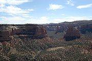 |
NPS National Park Service The National Park Service is the U.S. federal agency that manages all national parks, many national monuments, and other conservation and historical properties with various title designations... |
Colorado Colorado Colorado is a U.S. state that encompasses much of the Rocky Mountains as well as the northeastern portion of the Colorado Plateau and the western edge of the Great Plains... 39.04°N 108.69°W |
Monument Canyon runs the width of the park and includes rock formations formed by erosion. The monument includes 20500 acres (83 km²) of semi-desert land high on the Colorado Plateau Colorado Plateau The Colorado Plateau, also called the Colorado Plateau Province, is a physiographic region of the Intermontane Plateaus, roughly centered on the Four Corners region of the southwestern United States. The province covers an area of 337,000 km2 within western Colorado, northwestern New Mexico,... and has a wide range of wildlife including pinyon pine Pinyon pine The pinyon pine group grows in the southwestern United States and in Mexico. The trees yield edible pinyon nuts, which were a staple of the Native Americans, and are still widely eaten... s, juniper Juniper Junipers are coniferous plants in the genus Juniperus of the cypress family Cupressaceae. Depending on taxonomic viewpoint, there are between 50-67 species of juniper, widely distributed throughout the northern hemisphere, from the Arctic, south to tropical Africa in the Old World, and to the... trees, raven Raven Raven is the common name given to several larger-bodied members of the genus Corvus—but in Europe and North America the Common Raven is normally implied... s, jay Jay The jays are several species of medium-sized, usually colorful and noisy, passerine birds in the crow family Corvidae. The names jay and magpie are somewhat interchangeable, and the evolutionary relationships are rather complex... s, Desert Bighorn Sheep Desert Bighorn Sheep The Desert Bighorn Sheep is a subspecies of Bighorn Sheep that occurs in the desert Southwest regions of the United States and in the northern regions of Mexico. The trinomial of this species commemorates the American naturalist Edward William Nelson... , and coyote Coyote The coyote , also known as the American jackal or the prairie wolf, is a species of canine found throughout North and Central America, ranging from Panama in the south, north through Mexico, the United States and Canada... s as well as a range of recreational activities. |
|
| Craters of the Moon Craters of the Moon National Monument and Preserve Craters of the Moon National Monument and Preserve is a national monument and national preserve located in the Snake River Plain in central Idaho, U.S.A. It is along US 20 , between the small cities of Arco and Carey, at an average elevation of above sea level... |
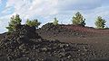 |
NPS National Park Service The National Park Service is the U.S. federal agency that manages all national parks, many national monuments, and other conservation and historical properties with various title designations... , BLM Bureau of Land Management The Bureau of Land Management is an agency within the United States Department of the Interior which administers America's public lands, totaling approximately , or one-eighth of the landmass of the country. The BLM also manages of subsurface mineral estate underlying federal, state and private... |
Idaho Idaho Idaho is a state in the Rocky Mountain area of the United States. The state's largest city and capital is Boise. Residents are called "Idahoans". Idaho was admitted to the Union on July 3, 1890, as the 43rd state.... 43.42°N 113.52°W |
One of the best preserved flood basalt Flood basalt A flood basalt or trap basalt is the result of a giant volcanic eruption or series of eruptions that coats large stretches of land or the ocean floor with basalt lava. Flood basalts have occurred on continental scales in prehistory, creating great plateaus and mountain ranges... areas in the continental U.S. contains three lava fields along the Great Rift of Idaho as well as the world's deepest open rift Rift In geology, a rift or chasm is a place where the Earth's crust and lithosphere are being pulled apart and is an example of extensional tectonics.... cracks and other volcanic features. |
|
| Devils Postpile Devils Postpile National Monument Devils Postpile National Monument is located near Mammoth Mountain in extreme northeastern Madera County in eastern California. It was established in 1911, and protects Devils Postpile, an unusual formation of columnar basalt.-Geography:... |
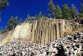 |
NPS National Park Service The National Park Service is the U.S. federal agency that manages all national parks, many national monuments, and other conservation and historical properties with various title designations... |
California California California is a state located on the West Coast of the United States. It is by far the most populous U.S. state, and the third-largest by land area... 37.50°N 119.08°W |
Once part of Yosemite National Park, this monument is a dark cliff of columnar basalt created by a lava flow at least 100,000 years ago. It also has the 101 feet (30.8 m)-high Rainbow Falls. | |
| Devils Tower Devils Tower National Monument Devils Tower is an igneous intrusion or laccolith located in the Black Hills near Hulett and Sundance in Crook County, northeastern Wyoming, above the Belle Fourche River... |
 |
NPS National Park Service The National Park Service is the U.S. federal agency that manages all national parks, many national monuments, and other conservation and historical properties with various title designations... |
Wyoming Wyoming Wyoming is a state in the mountain region of the Western United States. The western two thirds of the state is covered mostly with the mountain ranges and rangelands in the foothills of the Eastern Rocky Mountains, while the eastern third of the state is high elevation prairie known as the High... 44.59°N 104.72°W |
The tower is a monolith Monolith A monolith is a geological feature such as a mountain, consisting of a single massive stone or rock, or a single piece of rock placed as, or within, a monument... ic igneous Igneous rock Igneous rock is one of the three main rock types, the others being sedimentary and metamorphic rock. Igneous rock is formed through the cooling and solidification of magma or lava... intrusion Intrusion An intrusion is liquid rock that forms under Earth's surface. Magma from under the surface is slowly pushed up from deep within the earth into any cracks or spaces it can find, sometimes pushing existing country rock out of the way, a process that can take millions of years. As the rock slowly... of volcanic neck rising dramatically 1267 feet (386.2 m) above the surrounding terrain. Proclaimed by Theodore Roosevelt, this was the first national monument. |
|
| Dinosaur Dinosaur National Monument Dinosaur National Monument is a National Monument located on the southeast flank of the Uinta Mountains on the border between Colorado and Utah at the confluence of the Green and Yampa Rivers. Although most of the monument area is in Moffat County, Colorado, the Dinosaur Quarry is located in Utah... |
 |
NPS National Park Service The National Park Service is the U.S. federal agency that manages all national parks, many national monuments, and other conservation and historical properties with various title designations... |
Colorado Colorado Colorado is a U.S. state that encompasses much of the Rocky Mountains as well as the northeastern portion of the Colorado Plateau and the western edge of the Great Plains... , Utah Utah Utah is a state in the Western United States. It was the 45th state to join the Union, on January 4, 1896. Approximately 80% of Utah's 2,763,885 people live along the Wasatch Front, centering on Salt Lake City. This leaves vast expanses of the state nearly uninhabited, making the population the... 40.53°N 108.98°W |
This sandstone Sandstone Sandstone is a sedimentary rock composed mainly of sand-sized minerals or rock grains.Most sandstone is composed of quartz and/or feldspar because these are the most common minerals in the Earth's crust. Like sand, sandstone may be any colour, but the most common colours are tan, brown, yellow,... and conglomerate Conglomerate (geology) A conglomerate is a rock consisting of individual clasts within a finer-grained matrix that have become cemented together. Conglomerates are sedimentary rocks consisting of rounded fragments and are thus differentiated from breccias, which consist of angular clasts... bed, known as the Morrison Formation Morrison Formation The Morrison Formation is a distinctive sequence of Late Jurassic sedimentary rock that is found in the western United States, which has been the most fertile source of dinosaur fossils in North America. It is composed of mudstone, sandstone, siltstone and limestone and is light grey, greenish... , was formed in the Jurassic Jurassic The Jurassic is a geologic period and system that extends from about Mya to Mya, that is, from the end of the Triassic to the beginning of the Cretaceous. The Jurassic constitutes the middle period of the Mesozoic era, also known as the age of reptiles. The start of the period is marked by... Period and contains fossils of dinosaurs including Allosaurus Allosaurus Allosaurus is a genus of large theropod dinosaur that lived 155 to 150 million years ago during the late Jurassic period . The name Allosaurus means "different lizard". It is derived from the Greek /allos and /sauros... and various long-neck and long-tail sauropods. |
|
| Effigy Mounds Effigy Mounds National Monument Effigy Mounds National Monument preserves three prehistoric sites in Allamakee County and Clayton County, Iowa in the midwestern United States.-Mounds:... |
 |
NPS National Park Service The National Park Service is the U.S. federal agency that manages all national parks, many national monuments, and other conservation and historical properties with various title designations... |
Iowa Iowa Iowa is a state located in the Midwestern United States, an area often referred to as the "American Heartland". It derives its name from the Ioway people, one of the many American Indian tribes that occupied the state at the time of European exploration. Iowa was a part of the French colony of New... 43.09°N 91.19°W |
This monument preserves three prehistoric sites with 206 prehistoric mounds, notable for 31 unusual mounds in the shape of mammals, birds, or reptiles. | |
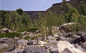
| El Malpais El Malpais National Monument El Malpais National Monument is a National Monument located in western New Mexico, in the Southwestern United States. The name El Malpais is from the Spanish term Malpaís, meaning badlands, due to the extremely barren and dramatic volcanic field that covers much of the park's area.-Geography:The El... |
 |
NPS National Park Service The National Park Service is the U.S. federal agency that manages all national parks, many national monuments, and other conservation and historical properties with various title designations... |
New Mexico New Mexico New Mexico is a state located in the southwest and western regions of the United States. New Mexico is also usually considered one of the Mountain States. With a population density of 16 per square mile, New Mexico is the sixth-most sparsely inhabited U.S... 34.88°N 108.05°W |
An extremely rough, rugged lava Lava Lava refers both to molten rock expelled by a volcano during an eruption and the resulting rock after solidification and cooling. This molten rock is formed in the interior of some planets, including Earth, and some of their satellites. When first erupted from a volcanic vent, lava is a liquid at... flow covers much of the park, filling a large basin rimmed by higher sandstone that forms large, wind-carved bluffs. It has lava tube Lava tube Lava tubes are natural conduits through which lava travels beneath the surface of a lava flow, expelled by a volcano during an eruption. They can be actively draining lava from a source, or can be extinct, meaning the lava flow has ceased and the rock has cooled and left a long, cave-like... caves that stretch over 17 miles (27.4 km) and the Cebolla Wilderness, a forested rimrock area that features prehistoric rock art and the Zuni-Acoma Trail, an ancient Pueblo trade route. |
|
| El Morro El Morro National Monument El Morro National Monument is located on an ancient east-west trail in western New Mexico. The main feature of this National Monument is a great sandstone promontory with a pool of water at its base. As a shaded oasis in the western U.S. desert, this site has seen many centuries of travelers... |
 |
NPS National Park Service The National Park Service is the U.S. federal agency that manages all national parks, many national monuments, and other conservation and historical properties with various title designations... |
New Mexico New Mexico New Mexico is a state located in the southwest and western regions of the United States. New Mexico is also usually considered one of the Mountain States. With a population density of 16 per square mile, New Mexico is the sixth-most sparsely inhabited U.S... 35.04°N 108.35°W |
On the site of an ancient east-west trail is a great sandstone promontory with a pool of water at its base. There are inscriptions from the 17th century as well as older petroglyph Petroglyph Petroglyphs are pictogram and logogram images created by removing part of a rock surface by incising, picking, carving, and abrading. Outside North America, scholars often use terms such as "carving", "engraving", or other descriptions of the technique to refer to such images... s made by the Anasazi. |
|
| Florissant Fossil Beds Florissant Fossil Beds National Monument Florissant Fossil Beds National Monument is a United States National Monument in Teller County, Colorado, that is noted for its fossils. It is located in a mountain valley just west of Pikes Peak and holds spectacular remnants of prehistoric life... |
 |
NPS National Park Service The National Park Service is the U.S. federal agency that manages all national parks, many national monuments, and other conservation and historical properties with various title designations... |
Colorado Colorado Colorado is a U.S. state that encompasses much of the Rocky Mountains as well as the northeastern portion of the Colorado Plateau and the western edge of the Great Plains... 38.92°N 105.27°W |
Huge petrified redwoods and incredibly detailed fossil Fossil Fossils are the preserved remains or traces of animals , plants, and other organisms from the remote past... s of ancient insects and plants reveal a very different landscape in Colorado Colorado Colorado is a U.S. state that encompasses much of the Rocky Mountains as well as the northeastern portion of the Colorado Plateau and the western edge of the Great Plains... of almost 35 million years ago in the Eocene Eocene The Eocene Epoch, lasting from about 56 to 34 million years ago , is a major division of the geologic timescale and the second epoch of the Paleogene Period in the Cenozoic Era. The Eocene spans the time from the end of the Palaeocene Epoch to the beginning of the Oligocene Epoch. The start of the... age. |
|
| Fort Frederica Fort Frederica National Monument Fort Frederica National Monument, on St. Simons Island, Georgia, preserves the archaeological remnants of a fort and town built by James Oglethorpe between 1736 and 1748 to protect the southern boundary of the British colony of Georgia from Spanish raids. About 630 British troops were stationed at... |
 |
NPS National Park Service The National Park Service is the U.S. federal agency that manages all national parks, many national monuments, and other conservation and historical properties with various title designations... |
Georgia Georgia (U.S. state) Georgia is a state located in the southeastern United States. It was established in 1732, the last of the original Thirteen Colonies. The state is named after King George II of Great Britain. Georgia was the fourth state to ratify the United States Constitution, on January 2, 1788... 31.224°N 81.393°W |
Built by James Oglethorpe James Oglethorpe James Edward Oglethorpe was a British general, member of Parliament, philanthropist, and founder of the colony of Georgia... between 1736 and 1748, these remnants of a fort and town protected the southern boundary of the British colony of Georgia Province of Georgia The Province of Georgia was one of the Southern colonies in British America. It was the last of the thirteen original colonies established by Great Britain in what later became the United States... from Spanish Spain Spain , officially the Kingdom of Spain languages]] under the European Charter for Regional or Minority Languages. In each of these, Spain's official name is as follows:;;;;;;), is a country and member state of the European Union located in southwestern Europe on the Iberian Peninsula... raids. It was a few miles from the site of the Battle of Bloody Marsh Battle of Bloody Marsh The Battle of Bloody Marsh took place on July 18, 1742 between Spanish and British forces, and the latter were victorious. Part of the War of Jenkin's Ear, the battle was for control of the road between the British forts of Frederica and St. Simons, to control St. Simons Island and the forts'... . |
|
| Fort Matanzas Fort Matanzas National Monument Commemorated in 1924, Fort Matanzas National Monument is a United States National Monument run by the National Park Service. The Monument consists of a 1740 Spanish fort, Fort Matanzas, and about 100 acres of salt marsh and barrier islands along the Matanzas River on the northern Atlantic coast... |
 |
NPS National Park Service The National Park Service is the U.S. federal agency that manages all national parks, many national monuments, and other conservation and historical properties with various title designations... |
Florida Florida Florida is a state in the southeastern United States, located on the nation's Atlantic and Gulf coasts. It is bordered to the west by the Gulf of Mexico, to the north by Alabama and Georgia and to the east by the Atlantic Ocean. With a population of 18,801,310 as measured by the 2010 census, it... 29.715°N 81.239°W |
This 1740 Spanish fort guarded Matanzas Inlet Matanzas Inlet Matanzas Inlet is a channel in Florida between barrier islands connecting the Atlantic Ocean and the south end of the Matanzas River. It is south of St. Augustine, in the southern part of St. Johns County, at coordinates... , the southern mouth of the Matanzas River Matanzas River Matanzas River is a body of water located in St. Johns and Flagler counties in Florida. It is a narrow saltwater bar-bounded estuary sheltered from the Atlantic Ocean by Anastasia Island.... , which allowed access to St. Augustine St. Augustine, Florida St. Augustine is a city in the northeast section of Florida and the county seat of St. Johns County, Florida, United States. Founded in 1565 by Spanish explorer and admiral Pedro Menéndez de Avilés, it is the oldest continuously occupied European-established city and port in the continental United... . The monument is managed in conjunction with Castillo de San Marcos National Monument Castillo de San Marcos The Castillo de San Marcos site is the oldest masonry fort in the United States. It is located in the city of St. Augustine, Florida. Construction was begun in 1672 by the Spanish when Florida was a Spanish territory. During the twenty year period of British possession from 1763 until 1784, the... and also protects 100 acre (0.404686 km²) of salt marsh Salt marsh A salt marsh is an environment in the upper coastal intertidal zone between land and salt water or brackish water, it is dominated by dense stands of halophytic plants such as herbs, grasses, or low shrubs. These plants are terrestrial in origin and are essential to the stability of the salt marsh... and barrier island Barrier island Barrier islands, a coastal landform and a type of barrier system, are relatively narrow strips of sand that parallel the mainland coast. They usually occur in chains, consisting of anything from a few islands to more than a dozen... s. |
|
| Fort McHenry Fort McHenry Fort McHenry, in Baltimore, Maryland, is a star-shaped fort best known for its role in the War of 1812, when it successfully defended Baltimore Harbor from an attack by the British navy in Chesapeake Bay... |
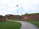 |
NPS National Park Service The National Park Service is the U.S. federal agency that manages all national parks, many national monuments, and other conservation and historical properties with various title designations... |
Maryland Maryland Maryland is a U.S. state located in the Mid Atlantic region of the United States, bordering Virginia, West Virginia, and the District of Columbia to its south and west; Pennsylvania to its north; and Delaware to its east... 39.263°N 76.579°W |
The only place designated a national monument and historic shrine, Fort McHenry is a star-shaped fort Star fort A star fort, or trace italienne, is a fortification in the style that evolved during the age of gunpowder, when cannon came to dominate the battlefield, and was first seen in the mid-15th century in Italy.... best known for its role in the War of 1812 War of 1812 The War of 1812 was a military conflict fought between the forces of the United States of America and those of the British Empire. The Americans declared war in 1812 for several reasons, including trade restrictions because of Britain's ongoing war with France, impressment of American merchant... when it successfully defended Baltimore Harbor Inner Harbor The Inner Harbor is a historic seaport, tourist attraction, and iconic landmark of the City of Baltimore, Maryland, United States. Described by the Urban Land Institute in 2009 as “the model for post-industrial waterfront redevelopment around the World.” The Inner Harbor is actually the end of the... from an attack by the British United Kingdom of Great Britain and Ireland The United Kingdom of Great Britain and Ireland was the formal name of the United Kingdom during the period when what is now the Republic of Ireland formed a part of it.... navy Royal Navy The Royal Navy is the naval warfare service branch of the British Armed Forces. Founded in the 16th century, it is the oldest service branch and is known as the Senior Service... . It inspired Francis Scott Key Francis Scott Key Francis Scott Key was an American lawyer, author, and amateur poet, from Georgetown, who wrote the lyrics to the United States' national anthem, "The Star-Spangled Banner".-Life:... to write "The Star-Spangled Banner The Star-Spangled Banner "The Star-Spangled Banner" is the national anthem of the United States of America. The lyrics come from "Defence of Fort McHenry", a poem written in 1814 by the 35-year-old lawyer and amateur poet, Francis Scott Key, after witnessing the bombardment of Fort McHenry by the British Royal Navy ships... ". |
|
| Fort Monroe Fort Monroe Fort Monroe was a military installation in Hampton, Virginia—at Old Point Comfort, the southern tip of the Virginia Peninsula... |
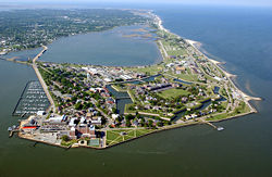 |
NPS National Park Service The National Park Service is the U.S. federal agency that manages all national parks, many national monuments, and other conservation and historical properties with various title designations... |
Virginia Virginia The Commonwealth of Virginia , is a U.S. state on the Atlantic Coast of the Southern United States. Virginia is nicknamed the "Old Dominion" and sometimes the "Mother of Presidents" after the eight U.S. presidents born there... 37.004°N 76.308°W |
Fort Monroe National Monument spans the American story from the 17th to the 21st centuries: Captain John Smith's journeys, a haven of freedom for the enslaved during the Civil War, and a bastion of defense for the Chesapeake Bay Chesapeake Bay The Chesapeake Bay is the largest estuary in the United States. It lies off the Atlantic Ocean, surrounded by Maryland and Virginia. The Chesapeake Bay's drainage basin covers in the District of Columbia and parts of six states: New York, Pennsylvania, Delaware, Maryland, Virginia, and West... . |
|
| Fort Pulaski Fort Pulaski National Monument Fort Pulaski National Monument is located between Savannah and Tybee Island, Georgia. It preserves Fort Pulaski, notable as the place where, during the American Civil War, in 1862, the Union Army successfully tested a rifled cannon. The success of the test rendered brick fortifications obsolete.... |
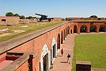 |
NPS National Park Service The National Park Service is the U.S. federal agency that manages all national parks, many national monuments, and other conservation and historical properties with various title designations... |
Georgia Georgia (U.S. state) Georgia is a state located in the southeastern United States. It was established in 1732, the last of the original Thirteen Colonies. The state is named after King George II of Great Britain. Georgia was the fourth state to ratify the United States Constitution, on January 2, 1788... 32.027°N 80.890°W |
In 1862 during the American Civil War American Civil War The American Civil War was a civil war fought in the United States of America. In response to the election of Abraham Lincoln as President of the United States, 11 southern slave states declared their secession from the United States and formed the Confederate States of America ; the other 25... , the Union Army Union Army The Union Army was the land force that fought for the Union during the American Civil War. It was also known as the Federal Army, the U.S. Army, the Northern Army and the National Army... successfully tested a rifled Rifling Rifling is the process of making helical grooves in the barrel of a gun or firearm, which imparts a spin to a projectile around its long axis... cannon Cannon A cannon is any piece of artillery that uses gunpowder or other usually explosive-based propellents to launch a projectile. Cannon vary in caliber, range, mobility, rate of fire, angle of fire, and firepower; different forms of cannon combine and balance these attributes in varying degrees,... against the defending Confederates, rendering brick fortifications obsolete. Fort Pulaski was also used as a prisoner-of-war camp Prisoner-of-war camp A prisoner-of-war camp is a site for the containment of combatants captured by their enemy in time of war, and is similar to an internment camp which is used for civilian populations. A prisoner of war is generally a soldier, sailor, or airman who is imprisoned by an enemy power during or... during the war. The national monument includes most of Cockspur Island Cockspur Island Cockspur Island is an island in the south channel of the Savannah River near Lazaretto Creek, northwest of Tybee Island, Georgia, USA. Most of the island is within the boundaries of Fort Pulaski National Monument.... (containing the fort) and all of adjacent McQueens Island. |
|
| Fort Stanwix Fort Stanwix Fort Stanwix was a colonial fort whose construction was started on August 26, 1758, by British General John Stanwix, at the location of present-day Rome, New York, but was not completed until about 1762. The fort guarded a portage known as the Oneida Carrying Place during the French and Indian War... |
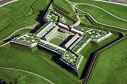 |
NPS National Park Service The National Park Service is the U.S. federal agency that manages all national parks, many national monuments, and other conservation and historical properties with various title designations... |
New York New York New York is a state in the Northeastern region of the United States. It is the nation's third most populous state. New York is bordered by New Jersey and Pennsylvania to the south, and by Connecticut, Massachusetts and Vermont to the east... 43.218°N 75.459°W |
Fort Stanwix guarded a portage Portage Portage or portaging refers to the practice of carrying watercraft or cargo over land to avoid river obstacles, or between two bodies of water. A place where this carrying occurs is also called a portage; a person doing the carrying is called a porter.The English word portage is derived from the... known as the Oneida Carrying Place Oneida Carry -Overview:The Oneida Carry was an important link in the trade route between Albany, New York, Oneida Lake, and Lake Ontario during the 18th Century... during the French and Indian War French and Indian War The French and Indian War is the common American name for the war between Great Britain and France in North America from 1754 to 1763. In 1756, the war erupted into the world-wide conflict known as the Seven Years' War and thus came to be regarded as the North American theater of that war... . In 1768, the Treaty of Fort Stanwix Treaty of Fort Stanwix The Treaty of Fort Stanwix was an important treaty between North American Indians and the British Empire. It was signed in 1768 at Fort Stanwix, located in present-day Rome, New York... was negotiated between the British and the Iroquois Iroquois The Iroquois , also known as the Haudenosaunee or the "People of the Longhouse", are an association of several tribes of indigenous people of North America... , which led to further hostilities. It fell into ruin and was rebuilt in the late 1970s. |
|
| Fort Sumter Fort Sumter Fort Sumter is a Third System masonry coastal fortification located in Charleston Harbor, South Carolina. The fort is best known as the site upon which the shots initiating the American Civil War were fired, at the Battle of Fort Sumter.- Construction :... |
NPS National Park Service The National Park Service is the U.S. federal agency that manages all national parks, many national monuments, and other conservation and historical properties with various title designations... |
South Carolina South Carolina South Carolina is a state in the Deep South of the United States that borders Georgia to the south, North Carolina to the north, and the Atlantic Ocean to the east. Originally part of the Province of Carolina, the Province of South Carolina was one of the 13 colonies that declared independence... 32.752°N 79.874°W |
Fort Sumter is a Third System masonry coastal fortification located in Charleston Charleston, South Carolina Charleston is the second largest city in the U.S. state of South Carolina. It was made the county seat of Charleston County in 1901 when Charleston County was founded. The city's original name was Charles Towne in 1670, and it moved to its present location from a location on the west bank of the... harbor, South Carolina South Carolina South Carolina is a state in the Deep South of the United States that borders Georgia to the south, North Carolina to the north, and the Atlantic Ocean to the east. Originally part of the Province of Carolina, the Province of South Carolina was one of the 13 colonies that declared independence... . It is best known as the site where the shots initiating the American Civil War American Civil War The American Civil War was a civil war fought in the United States of America. In response to the election of Abraham Lincoln as President of the United States, 11 southern slave states declared their secession from the United States and formed the Confederate States of America ; the other 25... were fired, at the Battle of Fort Sumter Battle of Fort Sumter The Battle of Fort Sumter was the bombardment and surrender of Fort Sumter, near Charleston, South Carolina, that started the American Civil War. Following declarations of secession by seven Southern states, South Carolina demanded that the U.S. Army abandon its facilities in Charleston Harbor. On... . Nearby Fort Moultrie is a unit of this monument; it was made of palmetto logs and inspired the flag Flag of South Carolina The flag of the state of South Carolina dates back to 1765 when opponents of the Stamp Act marched in protest behind a blue flag bearing three white crescents. In 1775 Colonel William Moultrie was asked by the Revolutionary Council of Safety to design a flag for the South Carolina troops to use... and nickname (Palmetto State) of South Carolina South Carolina South Carolina is a state in the Deep South of the United States that borders Georgia to the south, North Carolina to the north, and the Atlantic Ocean to the east. Originally part of the Province of Carolina, the Province of South Carolina was one of the 13 colonies that declared independence... . |
||
| Fort Union Fort Union National Monument Fort Union National Monument is a unit of the National Park Service located north of Watrous, Mora County, New Mexico, USA. The national monument was founded on June 28, 1954.... |
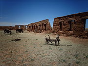 |
NPS National Park Service The National Park Service is the U.S. federal agency that manages all national parks, many national monuments, and other conservation and historical properties with various title designations... |
New Mexico New Mexico New Mexico is a state located in the southwest and western regions of the United States. New Mexico is also usually considered one of the Mountain States. With a population density of 16 per square mile, New Mexico is the sixth-most sparsely inhabited U.S... 35.925°N 105.009°W |
A frontier military post and supply depot in the late 19th century, it sat at the intersection of the Mountain and Cimarron Branches of the old Santa Fe Trail Santa Fe Trail The Santa Fe Trail was a 19th-century transportation route through central North America that connected Missouri with Santa Fe, New Mexico. Pioneered in 1822 by William Becknell, it served as a vital commercial and military highway until the introduction of the railroad to Santa Fe in 1880... . |
|
| Fossil Butte Fossil Butte National Monument Fossil Butte National Monument is a unit of the National Park Service located 15 miles west of Kemmerer, Wyoming; the national monument was established on October 23, 1972. The site preserves the best paleontological record of Tertiary aquatic communities in North America and possibly the world,... |
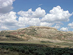 |
NPS National Park Service The National Park Service is the U.S. federal agency that manages all national parks, many national monuments, and other conservation and historical properties with various title designations... |
Wyoming Wyoming Wyoming is a state in the mountain region of the Western United States. The western two thirds of the state is covered mostly with the mountain ranges and rangelands in the foothills of the Eastern Rocky Mountains, while the eastern third of the state is high elevation prairie known as the High... 41.86°N 110.77°W |
Fossil Butte preserves the 50-million-year-old Green River Green River Formation The Green River Formation is an Eocene geologic formation that records the sedimentation in a group of intermountain lakes. The sediments are deposited in very fine layers, a dark layer during the growing season and a light-hue inorganic layer in winter. Each pair of layers is called a varve and... lake beds, the best paleontological Paleontology Paleontology "old, ancient", ὄν, ὀντ- "being, creature", and λόγος "speech, thought") is the study of prehistoric life. It includes the study of fossils to determine organisms' evolution and interactions with each other and their environments... record of tertiary Tertiary The Tertiary is a deprecated term for a geologic period 65 million to 2.6 million years ago. The Tertiary covered the time span between the superseded Secondary period and the Quaternary... aquatic communities in North America. Fossils including fish, alligators, bats, turtles, dog-sized horses, insects, and many other species of plants and animals suggest that the region was a low, subtropical, freshwater basin when the sediments accumulated, over about a 2-million-year period. |
|
| George Washington Birthplace George Washington Birthplace National Monument The George Washington Birthplace National Monument is in Westmoreland County, Virginia, United States. Originally settled by John Washington, George Washington's great-grandfather, George Washington was born here on February 22, 1732... |
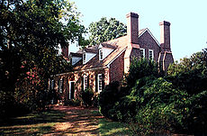 |
NPS National Park Service The National Park Service is the U.S. federal agency that manages all national parks, many national monuments, and other conservation and historical properties with various title designations... |
Virginia Virginia The Commonwealth of Virginia , is a U.S. state on the Atlantic Coast of the Southern United States. Virginia is nicknamed the "Old Dominion" and sometimes the "Mother of Presidents" after the eight U.S. presidents born there... 38.1861°N 76.9305°W |
Representative of 18th-century Virginia tobacco farms, this site is the birthplace and boyhood environment of George Washington George Washington George Washington was the dominant military and political leader of the new United States of America from 1775 to 1799. He led the American victory over Great Britain in the American Revolutionary War as commander-in-chief of the Continental Army from 1775 to 1783, and presided over the writing of... . The entrance includes a Memorial Shaft obelisk Obelisk An obelisk is a tall, four-sided, narrow tapering monument which ends in a pyramid-like shape at the top, and is said to resemble a petrified ray of the sun-disk. A pair of obelisks usually stood in front of a pylon... of Vermont marble that is a one-tenth scale replica of the Washington Monument Washington Monument The Washington Monument is an obelisk near the west end of the National Mall in Washington, D.C., built to commemorate the first U.S. president, General George Washington... in Washington, D.C. Also within the monument are the historic birthplace home area, a kitchen house, and the Washington family burial ground. |
|
| George Washington Carver George Washington Carver National Monument George Washington Carver National Monument is a unit of the National Park Service located about two miles west of Diamond, Missouri; the national monument was founded on July 14, 1943, by Franklin Delano Roosevelt who dedicated $30,000 US to the monument... |
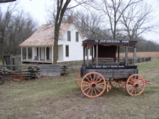 |
NPS National Park Service The National Park Service is the U.S. federal agency that manages all national parks, many national monuments, and other conservation and historical properties with various title designations... |
Missouri Missouri Missouri is a US state located in the Midwestern United States, bordered by Iowa, Illinois, Kentucky, Tennessee, Arkansas, Oklahoma, Kansas and Nebraska. With a 2010 population of 5,988,927, Missouri is the 18th most populous state in the nation and the fifth most populous in the Midwest. It... 36.986°N 94.354°W |
The site preserves Moses Carver Moses Carver Moses Carver was a settler and foster father of George Washington Carver.Moses Carver and his brother Richard migrated to southwest Missouri around 1838 from Ohio and Illinois. The Preemption Act of 1841 allowed farmers who lived on and improved of land for six months to buy the land from the... 's farm, which was the boyhood home of George Washington Carver George Washington Carver George Washington Carver , was an American scientist, botanist, educator, and inventor. The exact day and year of his birth are unknown; he is believed to have been born into slavery in Missouri in January 1864.... , a scientist and educator who developed many uses for peanut Peanut The peanut, or groundnut , is a species in the legume or "bean" family , so it is not a nut. The peanut was probably first cultivated in the valleys of Peru. It is an annual herbaceous plant growing tall... s. It was the first national monument dedicated to an African-American and first to a non-president. |
|
| Giant Sequoia Giant Sequoia National Monument The Giant Sequoia National Monument is a U.S. National Monument located in the southern Sierra Nevada in eastern central California. It is administered by the United States Forest Service as part of the Sequoia National Forest and includes 38 of the 39 Giant Sequoia groves that are located in the... |
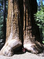 |
USFS | California California California is a state located on the West Coast of the United States. It is by far the most populous U.S. state, and the third-largest by land area... 36.04°N 118.50°W |
The monument includes 38 of the 39 Giant Sequoia groves in the Sequoia National Forest Sequoia National Forest Sequoia National Forest is located in the southern Sierra Nevada mountains of California. The U.S. National Forest is named for the majestic Giant Sequoia trees which populate 38 distinct groves within the boundaries of the forest.... , amounting to about half of the sequoia groves currently in existence. This includes one of the ten largest Giant Sequoias, the Boole Tree. Its two parts are around Kings Canyon Kings Canyon National Park Kings Canyon National Park is a National Park in the southern Sierra Nevada, east of Fresno, California. The park was established in 1940 and covers... and Sequoia National Park Sequoia National Park Sequoia National Park is a national park in the southern Sierra Nevada east of Visalia, California, in the United States. It was established on September 25, 1890. The park spans . Encompassing a vertical relief of nearly , the park contains among its natural resources the highest point in the... s. |
|
| Gila Cliff Dwellings Gila Cliff Dwellings National Monument Gila Cliff Dwellings National Monument is a U.S. National Monument in the Gila Wilderness of southwestern New Mexico. The national monument was established by executive proclamation on November 16, 1907, by President Theodore Roosevelt. It is located in the extreme southern part of Catron County... |
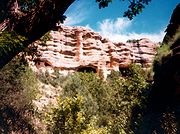 |
NPS National Park Service The National Park Service is the U.S. federal agency that manages all national parks, many national monuments, and other conservation and historical properties with various title designations... |
New Mexico New Mexico New Mexico is a state located in the southwest and western regions of the United States. New Mexico is also usually considered one of the Mountain States. With a population density of 16 per square mile, New Mexico is the sixth-most sparsely inhabited U.S... 33.24°N 108.28°W |
Located within the Gila Wilderness Gila Wilderness Gila Wilderness was designated the world's first wilderness area on June 3, 1924. Along with Aldo Leopold Wilderness and Blue Range Wilderness, the wilderness is part of New Mexico's Gila National Forest. The wilderness is approximately from north to south and east to west... , the people of the Mogollon culture lived in these cliff dwellings Cliff-dwelling Cliff dwelling is the general archaeological term for the habitations of prehistorical peoples, formed by using niches or caves in high cliffs, with more or less excavation or with additions in the way of masonry.... 180 feet (54.9 m) above the canyon floor from the 1280s through the early 14th century. They lived in five caves with 46 rooms. Henry B. Ailman discovered them in 1878. |
|
| Governors Island Governors Island National Monument Governors Island National Monument is located in New York, New York on of Governors Island, a island located few hundred meters off the southern tip of Manhattan at the confluence of the Hudson and East Rivers in New York Harbor.... |
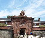 |
NPS National Park Service The National Park Service is the U.S. federal agency that manages all national parks, many national monuments, and other conservation and historical properties with various title designations... |
New York New York New York is a state in the Northeastern region of the United States. It is the nation's third most populous state. New York is bordered by New Jersey and Pennsylvania to the south, and by Connecticut, Massachusetts and Vermont to the east... 40.691°N 74.016°W |
From 1783 to 1966, Governors Island Governors Island Governors Island is a island in Upper New York Bay, approximately one-half mile from the southern tip of Manhattan Island and separated from Brooklyn by Buttermilk Channel. It is legally part of the borough of Manhattan in New York City... in New York Harbor New York Harbor New York Harbor refers to the waterways of the estuary near the mouth of the Hudson River that empty into New York Bay. It is one of the largest natural harbors in the world. Although the U.S. Board of Geographic Names does not use the term, New York Harbor has important historical, governmental,... was an Army United States Army The United States Army is the main branch of the United States Armed Forces responsible for land-based military operations. It is the largest and oldest established branch of the U.S. military, and is one of seven U.S. uniformed services... post, and from 1966 to 1996 it was a Coast Guard United States Coast Guard The United States Coast Guard is a branch of the United States Armed Forces and one of the seven U.S. uniformed services. The Coast Guard is a maritime, military, multi-mission service unique among the military branches for having a maritime law enforcement mission and a federal regulatory agency... installation. Located on Governors Island are Castle Williams Castle Williams Notes... and Fort Jay Fort Jay Fort Jay is a harbor fortification and the name of the former Army post located on Governors Island in New York Harbor. Fort Jay is the oldest defensive structure on the island, built to defend Upper New York Bay, but has served other purposes... , which served as outposts to protect New York City New York City New York is the most populous city in the United States and the center of the New York Metropolitan Area, one of the most populous metropolitan areas in the world. New York exerts a significant impact upon global commerce, finance, media, art, fashion, research, technology, education, and... from sea attack. |
|
| Grand Canyon-Parashant Grand Canyon-Parashant National Monument Grand Canyon-Parashant National Monument is located on the northern edge of the Grand Canyon in northwest Arizona. It was established by Presidential Proclamation 7265 on January 11, 2000... |
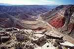 |
BLM Bureau of Land Management The Bureau of Land Management is an agency within the United States Department of the Interior which administers America's public lands, totaling approximately , or one-eighth of the landmass of the country. The BLM also manages of subsurface mineral estate underlying federal, state and private... , NPS National Park Service The National Park Service is the U.S. federal agency that manages all national parks, many national monuments, and other conservation and historical properties with various title designations... |
Arizona Arizona Arizona ; is a state located in the southwestern region of the United States. It is also part of the western United States and the mountain west. The capital and largest city is Phoenix... 36.4°N 113.7°W |
Located on the northern rim of the Grand Canyon Grand Canyon The Grand Canyon is a steep-sided canyon carved by the Colorado River in the United States in the state of Arizona. It is largely contained within the Grand Canyon National Park, the 15th national park in the United States... , this diverse landscape includes an array of scientific and historic resources. About 20,000 of the monument's 1017000 acres (4,115.7 km²) are also within Lake Mead National Recreation Area Lake Mead National Recreation Area Lake Mead National Recreation Area is located in southern Nevada and northwestern Arizona. The centerpieces of the National Recreation Area are its two large reservoirs: Lake Mead and Lake Mohave. These lakes cater to boaters, swimmers, sunbathers, and fishermen while the surrounding desert rewards... ; Grand Canyon-Parashant is not considered an official NPS unit. There are no paved roads or visitor services. |
|
| Grand Portage Grand Portage National Monument Grand Portage National Monument is a United States National Monument located on the north shore of Lake Superior in northeastern Minnesota that preserves a vital center of fur trade activity and Anishinaabeg Ojibwe heritage.... |
 |
NPS National Park Service The National Park Service is the U.S. federal agency that manages all national parks, many national monuments, and other conservation and historical properties with various title designations... |
Minnesota Minnesota Minnesota is a U.S. state located in the Midwestern United States. The twelfth largest state of the U.S., it is the twenty-first most populous, with 5.3 million residents. Minnesota was carved out of the eastern half of the Minnesota Territory and admitted to the Union as the thirty-second state... 47.96°N 89.68°W |
The Grand Portage itself is an 8.5 miles (13.7 km) footpath which bypasses a set of waterfalls on the Pigeon River Pigeon River (Minnesota-Ontario) The Pigeon River forms part of the US-Canada border between the State of Minnesota and the Province of Ontario west of Lake Superior. In pre-industrial times the river was a waterway of great importance for transportation and trade.-Geography:... near Lake Superior Lake Superior Lake Superior is the largest of the five traditionally-demarcated Great Lakes of North America. It is bounded to the north by the Canadian province of Ontario and the U.S. state of Minnesota, and to the south by the U.S. states of Wisconsin and Michigan. It is the largest freshwater lake in the... . The region was a vital trade route Trade route A trade route is a logistical network identified as a series of pathways and stoppages used for the commercial transport of cargo. Allowing goods to reach distant markets, a single trade route contains long distance arteries which may further be connected to several smaller networks of commercial... and center of fur trade Fur trade The fur trade is a worldwide industry dealing in the acquisition and sale of animal fur. Since the establishment of world market for in the early modern period furs of boreal, polar and cold temperate mammalian animals have been the most valued... activity as well as an Anishinaabeg Ojibwe heritage site. |
|
| Grand Staircase-Escalante Grand Staircase-Escalante National Monument The Grand Staircase-Escalante National Monument contains 1.9 million acres of land in southern Utah, the United States. There are three main regions: the Grand Staircase, the Kaiparowits Plateau, and the Canyons of the Escalante. President Bill Clinton designated the area as a U.S. National... |
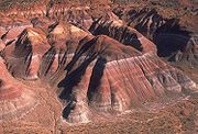 |
BLM Bureau of Land Management The Bureau of Land Management is an agency within the United States Department of the Interior which administers America's public lands, totaling approximately , or one-eighth of the landmass of the country. The BLM also manages of subsurface mineral estate underlying federal, state and private... |
Utah Utah Utah is a state in the Western United States. It was the 45th state to join the Union, on January 4, 1896. Approximately 80% of Utah's 2,763,885 people live along the Wasatch Front, centering on Salt Lake City. This leaves vast expanses of the state nearly uninhabited, making the population the... 37.4°N 111.68°W |
Preserving 1900000 acres (7,689 km²), the monument consists of the Grand Staircase Grand Staircase For the similarly named structure on the RMS Titanic, see Grand Staircase of the TitanicFor the stairs in the White House see Grand Staircase ... , the Kaiparowits Plateau Kaiparowits Plateau right|Location of the Kaiparowits Plateau within UtahThe Kaiparowits Plateau is a large, elevated landform located in southern Utah, in the southwestern United States. Along with the Grand Staircase and the Canyons of the Escalante, it makes up a significant portion of the Grand... , and the Canyons of the Escalante Escalante River right|Location of the Escalante River within UtahThe Escalante River is a tributary of the Colorado River. It is formed by the confluence of North and Birch Creeks near the town of Escalante in south-central Utah, and from there flows southeast for approximately before joining Lake Powell... . It is notable for its paleontological Paleontology Paleontology "old, ancient", ὄν, ὀντ- "being, creature", and λόγος "speech, thought") is the study of prehistoric life. It includes the study of fossils to determine organisms' evolution and interactions with each other and their environments... finds and geology, and it was the first monument to be maintained by the Bureau of Land Management Bureau of Land Management The Bureau of Land Management is an agency within the United States Department of the Interior which administers America's public lands, totaling approximately , or one-eighth of the landmass of the country. The BLM also manages of subsurface mineral estate underlying federal, state and private... . |
|
| Hagerman Fossil Beds Hagerman Fossil Beds National Monument Hagerman Fossil Beds National Monument near Hagerman, Idaho, contains the largest concentration of Hagerman Horse fossils in North America. The fossil horses for which the Monument is famous have been found in only one locale in the northern portion of the Monument called the Hagerman Horse Quarry... |
 |
NPS National Park Service The National Park Service is the U.S. federal agency that manages all national parks, many national monuments, and other conservation and historical properties with various title designations... |
Idaho Idaho Idaho is a state in the Rocky Mountain area of the United States. The state's largest city and capital is Boise. Residents are called "Idahoans". Idaho was admitted to the Union on July 3, 1890, as the 43rd state.... 42.79°N 114.95°W |
This monument contains the largest concentration of Hagerman Horse Hagerman Horse The Hagerman horse , also called the Hagerman zebra or the American zebra, was a North American species of equid from the Pliocene period and the Pleistocene period. It was one of the oldest horses of the genus Equus. Discovered in 1928 in Hagerman, Idaho, it is believed to have been like the... fossils in North America. It protects the world's richest known fossil deposits from the late Pliocene Pliocene The Pliocene Epoch is the period in the geologic timescale that extends from 5.332 million to 2.588 million years before present. It is the second and youngest epoch of the Neogene Period in the Cenozoic Era. The Pliocene follows the Miocene Epoch and is followed by the Pleistocene Epoch... epoch, 3.5 million years ago. These plants and animals represent the last glimpse of time that existed before the Ice Age Ice age An ice age or, more precisely, glacial age, is a generic geological period of long-term reduction in the temperature of the Earth's surface and atmosphere, resulting in the presence or expansion of continental ice sheets, polar ice sheets and alpine glaciers... , and the earliest appearances of modern flora and fauna. |
|
| Hanford Reach Hanford Reach National Monument The Hanford Reach National Monument is a national monument in the U.S. State of Washington. It was created in 2000, mostly from the former security buffer surrounding the Hanford Nuclear Reservation... |
 |
FWS | Washington 46.48°N 119.53°W |
Created from what used to be the security buffer surrounding the Hanford Nuclear Reservation, this area has been untouched by development or agriculture since 1943. The area is part of the Columbia River Plateau Columbia River Plateau The Columbia Plateau is a geologic and geographic region that lies across parts of the U.S. states of Washington, Oregon, and Idaho. It is a wide flood basalt plateau between the Cascade Range and the Rocky Mountains, cut through by the Columbia River... , formed by basalt lava flows and water erosion, and is named after the Hanford Reach Hanford Reach The Hanford Reach is a free-flowing section of the Columbia River, about long, in eastern Washington state, named after a large northward bend in the river's otherwise southbound course. It is the only section of the Columbia in the U.S... , the last free flowing section of the Columbia River Columbia River The Columbia River is the largest river in the Pacific Northwest region of North America. The river rises in the Rocky Mountains of British Columbia, Canada, flows northwest and then south into the U.S. state of Washington, then turns west to form most of the border between Washington and the state... . |
|
| Hohokam Pima Hohokam Pima National Monument The Hohokam Pima National Monument, which includes the archaeological site known as Snaketown, is an ancient Hohokam village within the Gila River Indian Community, near present day Sacaton, Arizona. Snaketown was designated a National Historic Landmark in 1964... |
 |
NPS National Park Service The National Park Service is the U.S. federal agency that manages all national parks, many national monuments, and other conservation and historical properties with various title designations... |
Arizona Arizona Arizona ; is a state located in the southwestern region of the United States. It is also part of the western United States and the mountain west. The capital and largest city is Phoenix... 33.19°N 111.91°W |
Hohokam Pima is part of the Gila River Indian Community Gila River Indian Community The Gila River Indian Community is an Indian reservation in the U.S. state of Arizona, lying adjacent to the south side of the city of Phoenix, within the Phoenix Metropolitan Area in Pinal and Maricopa Counties. It was established in 1859, and formally established by Congress in 1939... and not open to the public. The monument preserves the Snaketown Snaketown Snaketown is an archaeological site southeast of Phoenix, Arizona that was inhabited by the Hohokam people. Definitive dates are not clear, but the site was generally thought to be inhabited between 300 B. C. E. and 1200 C. E. Hohokam is an O’odham word meaning “those who have gone.” Specifically... -Settlement, archeological remains of the Hohokam Hohokam Hohokam is one of the four major prehistoric archaeological Oasisamerica traditions of what is now the American Southwest. Many local residents put the accent on the first syllable . Variant spellings in current, official usage include Hobokam, Huhugam and Huhukam... culture, which lived in the area until 1500. |
|
| Homestead Homestead National Monument of America Homestead National Monument of America, a unit of the National Park System, commemorates passage of the Homestead Act of 1862, which allowed any qualified person to claim up to of federally owned land in exchange for five years of residence and the cultivation and improvement of the property... |
 |
NPS National Park Service The National Park Service is the U.S. federal agency that manages all national parks, many national monuments, and other conservation and historical properties with various title designations... |
Nebraska Nebraska Nebraska is a state on the Great Plains of the Midwestern United States. The state's capital is Lincoln and its largest city is Omaha, on the Missouri River.... 40.285°N 96.822°W |
Daniel Freeman Daniel Freeman Daniel Freeman was an American homesteader, physician and Civil War veteran. He was recognized as the first person to file a claim under the Homestead Act of 1862... 's homestead was recognized by the United States Congress United States Congress The United States Congress is the bicameral legislature of the federal government of the United States, consisting of the Senate and the House of Representatives. The Congress meets in the United States Capitol in Washington, D.C.... as the first homestead in the nation obtained through the Homestead Act Homestead Act A homestead act is one of three United States federal laws that gave an applicant freehold title to an area called a "homestead" – typically 160 acres of undeveloped federal land west of the Mississippi River.... of 1862. The monument contains a visitor center, a tract of tallgrass prairie Tallgrass prairie The tallgrass prairie is an ecosystem native to central North America, with fire as its primary periodic disturbance. In the past, tallgrass prairies covered a large portion of the American Midwest, just east of the Great Plains, and portions of the Canadian Prairies. They flourished in areas with... , and the Freeman School. |
|
| Hovenweep Hovenweep National Monument Hovenweep National Monument is located on land in southwestern Colorado and southeastern Utah, located between Cortez, Colorado and Blanding, Utah on the Cajon Mesa of the Great Sage Plain... |
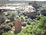 |
NPS National Park Service The National Park Service is the U.S. federal agency that manages all national parks, many national monuments, and other conservation and historical properties with various title designations... |
Colorado Colorado Colorado is a U.S. state that encompasses much of the Rocky Mountains as well as the northeastern portion of the Colorado Plateau and the western edge of the Great Plains... , Utah Utah Utah is a state in the Western United States. It was the 45th state to join the Union, on January 4, 1896. Approximately 80% of Utah's 2,763,885 people live along the Wasatch Front, centering on Salt Lake City. This leaves vast expanses of the state nearly uninhabited, making the population the... 37.38°N 109.08°W |
Hovenweep contains six clusters of Native American Native Americans in the United States Native Americans in the United States are the indigenous peoples in North America within the boundaries of the present-day continental United States, parts of Alaska, and the island state of Hawaii. They are composed of numerous, distinct tribes, states, and ethnic groups, many of which survive as... ruins. Holly Canyon, Hackberry Canyon, Cutthroat Castle and Goodman Point are in Colorado and Square Tower and Cajon are in Utah. Ancient Pueblo Peoples Ancient Pueblo Peoples Ancient Pueblo People or Ancestral Pueblo peoples were an ancient Native American culture centered on the present-day Four Corners area of the United States, comprising southern Utah, northern Arizona, northwest New Mexico, and southern Colorado... lived in the Hovenweep area from 1150 to 1350. |
|
| Ironwood Forest Ironwood Forest National Monument Ironwood Forest National Monument is located in the Sonoran Desert and the U.S. state of Arizona. Created by Bill Clinton by Presidential Proclamation 7320 on June 9, 2000, the 129,022 acre monument is managed by the U.S. Bureau of Land Management, an agency within the U.S. Department of the... |
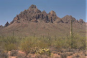 |
BLM Bureau of Land Management The Bureau of Land Management is an agency within the United States Department of the Interior which administers America's public lands, totaling approximately , or one-eighth of the landmass of the country. The BLM also manages of subsurface mineral estate underlying federal, state and private... |
Arizona Arizona Arizona ; is a state located in the southwestern region of the United States. It is also part of the western United States and the mountain west. The capital and largest city is Phoenix... 32.46°N 111.57°W |
Located within the Sonoran Desert Sonoran Desert The Sonoran Desert is a North American desert which straddles part of the United States-Mexico border and covers large parts of the U.S. states of Arizona and California and the northwest Mexican states of Sonora, Baja California, and Baja California Sur. It is one of the largest and hottest... , significant concentrations of ironwood (Olneya tesota Olneya tesota Olneya tesota is a perennial flowering tree of the Fabaceae family, legumes , which is commonly known as Ironwood or Desert Ironwood. It is the only species in the monotypic genus Olneya... ) trees and two endangered Endangered species An endangered species is a population of organisms which is at risk of becoming extinct because it is either few in numbers, or threatened by changing environmental or predation parameters... animal and plant species are found within the monument. More than 200 Hohokam Hohokam Hohokam is one of the four major prehistoric archaeological Oasisamerica traditions of what is now the American Southwest. Many local residents put the accent on the first syllable . Variant spellings in current, official usage include Hobokam, Huhugam and Huhukam... and Paleoindian archeological sites have been identified from between 600 and 1450 AD |
|
| Jewel Cave Jewel Cave National Monument Jewel Cave National Monument contains Jewel Cave, currently the second longest cave in the world, with just over of mapped passageways. It is located approximately west of the town of Custer in South Dakota's Black Hills... |
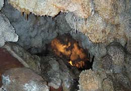 |
NPS National Park Service The National Park Service is the U.S. federal agency that manages all national parks, many national monuments, and other conservation and historical properties with various title designations... |
South Dakota South Dakota South Dakota is a state located in the Midwestern region of the United States. It is named after the Lakota and Dakota Sioux American Indian tribes. Once a part of Dakota Territory, South Dakota became a state on November 2, 1889. The state has an area of and an estimated population of just over... 43.73°N 103.83°W |
Jewel Cave is the second longest cave Cave A cave or cavern is a natural underground space large enough for a human to enter. The term applies to natural cavities some part of which is in total darkness. The word cave also includes smaller spaces like rock shelters, sea caves, and grottos.Speleology is the science of exploration and study... in the world, with about 141 miles (226.9 km) of mapped passageways. In the Black Hills Black Hills The Black Hills are a small, isolated mountain range rising from the Great Plains of North America in western South Dakota and extending into Wyoming, USA. Set off from the main body of the Rocky Mountains, the region is something of a geological anomaly—accurately described as an "island of... , it was discovered in 1900 and is so named because of its calcite Calcite Calcite is a carbonate mineral and the most stable polymorph of calcium carbonate . The other polymorphs are the minerals aragonite and vaterite. Aragonite will change to calcite at 380-470°C, and vaterite is even less stable.-Properties:... crystals. |
|
| John Day Fossil Beds John Day Fossil Beds National Monument John Day Fossil Beds National Monument is a U.S. National Monument in Wheeler and Grant counties in east-central Oregon. Located within the John Day River basin and managed by the National Park Service, the park is known for its well-preserved layers of fossil plants and mammals that lived in the... |
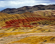 |
NPS National Park Service The National Park Service is the U.S. federal agency that manages all national parks, many national monuments, and other conservation and historical properties with various title designations... |
Oregon Oregon Oregon is a state in the Pacific Northwest region of the United States. It is located on the Pacific coast, with Washington to the north, California to the south, Nevada on the southeast and Idaho to the east. The Columbia and Snake rivers delineate much of Oregon's northern and eastern... 44.67°N 120.05°W |
Located within the John Day River John Day River The John Day River is a tributary of the Columbia River, approximately long, in northeastern Oregon in the United States. Undammed along its entire length, the river is the third longest free-flowing river in the conterminous United States. There is extensive use of its waters for irrigation. Its... Basin, the Fossil Beds have a well-preserved, complete record of fossil Fossil Fossils are the preserved remains or traces of animals , plants, and other organisms from the remote past... plants and animals from more than 40 of the 65 million years of the Cenozoic Era. The monument is divided into three units: Painted Hills Painted Hills Painted Hills is one of the three units of the John Day Fossil Beds National Monument, located in Wheeler County, Oregon.It totals and is located northwest of Mitchell, Oregon and east of Bend.... , named for its delicately colored stratifications Stratigraphy Stratigraphy, a branch of geology, studies rock layers and layering . It is primarily used in the study of sedimentary and layered volcanic rocks.... ; Sheep Rock; and Clarno. Blue Basin is a volcanic ash Volcanic ash Volcanic ash consists of small tephra, which are bits of pulverized rock and glass created by volcanic eruptions, less than in diameter. There are three mechanisms of volcanic ash formation: gas release under decompression causing magmatic eruptions; thermal contraction from chilling on contact... bowl transformed into claystone by eons of erosion Erosion Erosion is when materials are removed from the surface and changed into something else. It only works by hydraulic actions and transport of solids in the natural environment, and leads to the deposition of these materials elsewhere... , colored pastel blue by mineral Mineral A mineral is a naturally occurring solid chemical substance formed through biogeochemical processes, having characteristic chemical composition, highly ordered atomic structure, and specific physical properties. By comparison, a rock is an aggregate of minerals and/or mineraloids and does not... s. |
|
| Kasha-Katuwe Tent Rocks Kasha-Katuwe Tent Rocks National Monument Kasha-Katuwe Tent Rocks National Monument, located 40 miles southwest of Santa Fe, New Mexico , is a Bureau of Land Management managed site that was established as a U.S... |
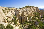 |
BLM Bureau of Land Management The Bureau of Land Management is an agency within the United States Department of the Interior which administers America's public lands, totaling approximately , or one-eighth of the landmass of the country. The BLM also manages of subsurface mineral estate underlying federal, state and private... |
New Mexico New Mexico New Mexico is a state located in the southwest and western regions of the United States. New Mexico is also usually considered one of the Mountain States. With a population density of 16 per square mile, New Mexico is the sixth-most sparsely inhabited U.S... 35.67°N 106.42°W |
Kasha-Katuwe is known for its geology of layers of volcanic rock and ash deposited by a volcanic explosion. Over time, weathering Weathering Weathering is the breaking down of rocks, soils and minerals as well as artificial materials through contact with the Earth's atmosphere, biota and waters... and erosion Erosion Erosion is when materials are removed from the surface and changed into something else. It only works by hydraulic actions and transport of solids in the natural environment, and leads to the deposition of these materials elsewhere... of these layers has created canyons and tent rock Tent Rock Tent Rock is a small nunatak shaped like a ridge tent, lying 1 nautical mile southwest of Thomas Rock and 7 nautical miles west of Ricker Hills in the Prince Albert Mountains, Oates Land. Mapped and descriptively named by the Southern Party of New Zealand Geological Survey Antarctic Expedition ,... s. The tent rocks themselves are cones of soft pumice Pumice Pumice is a textural term for a volcanic rock that is a solidified frothy lava typically created when super-heated, highly pressurized rock is violently ejected from a volcano. It can be formed when lava and water are mixed. This unusual formation is due to the simultaneous actions of rapid... and tuff Tuff Tuff is a type of rock consisting of consolidated volcanic ash ejected from vents during a volcanic eruption. Tuff is sometimes called tufa, particularly when used as construction material, although tufa also refers to a quite different rock. Rock that contains greater than 50% tuff is considered... beneath harder caprock Caprock The Caprock is a region in the Panhandle of Texas . It is the land to the west of the Caprock Escarpment, which separates it from plains stretching to the east at a much lower elevation.... s. |
|
| Lava Beds Lava Beds National Monument Lava Beds National Monument is located in northeastern California, in Siskiyou and Modoc Counties. The Monument lies on the northeastern flank of the Medicine Lake Volcano, with the largest total area covered by a volcano in the Cascade Range.... |
 |
NPS National Park Service The National Park Service is the U.S. federal agency that manages all national parks, many national monuments, and other conservation and historical properties with various title designations... |
California California California is a state located on the West Coast of the United States. It is by far the most populous U.S. state, and the third-largest by land area... 41.71°N 121.51°W |
This is the site of the largest concentration of lava tube Lava tube Lava tubes are natural conduits through which lava travels beneath the surface of a lava flow, expelled by a volcano during an eruption. They can be actively draining lava from a source, or can be extinct, meaning the lava flow has ceased and the rock has cooled and left a long, cave-like... cave Cave A cave or cavern is a natural underground space large enough for a human to enter. The term applies to natural cavities some part of which is in total darkness. The word cave also includes smaller spaces like rock shelters, sea caves, and grottos.Speleology is the science of exploration and study... s in North America North America North America is a continent wholly within the Northern Hemisphere and almost wholly within the Western Hemisphere. It is also considered a northern subcontinent of the Americas... . It also includes Petroglyph Point, one of the largest panels of Native American rock art. The monument lies on the northeast flank of the Medicine Lake Volcano Medicine Lake Volcano Medicine Lake Volcano is a large shield volcano in northeastern California about northeast of Mount Shasta. The volcano is located in a zone of east-west crustal extension east of the main axis of the Cascade Volcanic Arc and the Cascade Range. The thick shield is from east to west and from... , the largest volcano in the Cascade Range Cascade Range The Cascade Range is a major mountain range of western North America, extending from southern British Columbia through Washington and Oregon to Northern California. It includes both non-volcanic mountains, such as the North Cascades, and the notable volcanoes known as the High Cascades... . |
|
| Little Bighorn Battlefield Little Bighorn Battlefield National Monument Little Bighorn Battlefield National Monument preserves the site of the June 25, 1876, Battle of the Little Bighorn, near Crow Agency, Montana, in the United States. It also serves as a memorial to those who fought in the battle: George Armstrong Custer's 7th Cavalry and a combined Lakota-Northern... |
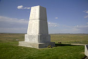 |
NPS National Park Service The National Park Service is the U.S. federal agency that manages all national parks, many national monuments, and other conservation and historical properties with various title designations... |
Montana Montana Montana is a state in the Western United States. The western third of Montana contains numerous mountain ranges. Smaller, "island ranges" are found in the central third of the state, for a total of 77 named ranges of the Rocky Mountains. This geographical fact is reflected in the state's name,... 45.57°N 107.43°W |
This monument includes the 1876 Battle of the Little Bighorn Battle of the Little Bighorn The Battle of the Little Bighorn, also known as Custer's Last Stand and, by the Indians involved, as the Battle of the Greasy Grass, was an armed engagement between combined forces of Lakota, Northern Cheyenne and Arapaho people against the 7th Cavalry Regiment of the United States Army... between George Armstrong Custer George Armstrong Custer George Armstrong Custer was a United States Army officer and cavalry commander in the American Civil War and the Indian Wars. Raised in Michigan and Ohio, Custer was admitted to West Point in 1858, where he graduated last in his class... 's 7th Cavalry U.S. 7th Cavalry Regiment The 7th Cavalry Regiment is a United States Army Cavalry Regiment, whose lineage traces back to the mid-19th century. Its official nickname is "Garryowen," in honor of the Irish air Garryowen that was adopted as its march tune.... and a combined Lakota-Northern Cheyenne and Arapaho Arapaho The Arapaho are a tribe of Native Americans historically living on the eastern plains of Colorado and Wyoming. They were close allies of the Cheyenne tribe and loosely aligned with the Sioux. Arapaho is an Algonquian language closely related to Gros Ventre, whose people are seen as an early... force, Custer National Cemetery, and the Reno-Benteen Battlefield. |
|
| Marianas Trench Marine Marianas Trench Marine National Monument The Marianas Trench Marine National Monument is a United States National Monument created by President George W. Bush by an executive order given on January 6, 2009.-Scope:... |
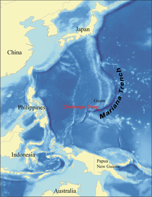 |
FWS | Northern Mariana Islands Northern Mariana Islands The Northern Mariana Islands, officially the Commonwealth of the Northern Mariana Islands , is a commonwealth in political union with the United States, occupying a strategic region of the western Pacific Ocean. It consists of 15 islands about three-quarters of the way from Hawaii to the Philippines... 20°N 145°W |
Covering over 95000 mi2, this marine monument includes the waters and submerged lands of the three northernmost islands of the Mariana Archipelago Mariana Islands The Mariana Islands are an arc-shaped archipelago made up by the summits of 15 volcanic mountains in the north-western Pacific Ocean between the 12th and 21st parallels north and along the 145th meridian east... , the submerged lands of 22 designated volcanic sites, and the Mariana Trench Mariana Trench The Mariana Trench or Marianas Trench is the deepest part of the world's oceans. It is located in the western Pacific Ocean, to the east of the Mariana Islands. The trench is about long but has a mean width of only... . |
|
| Misty Fjords Misty Fjords National Monument Misty Fiords National Monument is a National Monument and Wilderness Area administered by the US Department of Agriculture United States Forest Service 40 miles east of Ketchikan, Alaska, along the Inside Passage coast in extreme southeastern Alaska and covering 2,294,343 acres of Tongass... |
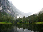 |
USFS | Alaska Alaska Alaska is the largest state in the United States by area. It is situated in the northwest extremity of the North American continent, with Canada to the east, the Arctic Ocean to the north, and the Pacific Ocean to the west and south, with Russia further west across the Bering Strait... 55.62°N 130.61°W |
Located within the Tongass National Forest Tongass National Forest The Tongass National Forest in southeastern Alaska is the largest national forest in the United States at 17 million acres . Most of its area is part of the temperate rain forest WWF ecoregion, itself part of the larger Pacific temperate rain forest WWF ecoregion, and is remote enough to be home... and called The Yosemite Yosemite National Park Yosemite National Park is a United States National Park spanning eastern portions of Tuolumne, Mariposa and Madera counties in east central California, United States. The park covers an area of and reaches across the western slopes of the Sierra Nevada mountain chain... of the North for its similar geology, it also contains the Quartz Hill molybdenum Molybdenum Molybdenum , is a Group 6 chemical element with the symbol Mo and atomic number 42. The name is from Neo-Latin Molybdaenum, from Ancient Greek , meaning lead, itself proposed as a loanword from Anatolian Luvian and Lydian languages, since its ores were confused with lead ores... deposit, possibly the largest such mineral deposit in the world. Throughout the monument is light-colored granite Granite Granite is a common and widely occurring type of intrusive, felsic, igneous rock. Granite usually has a medium- to coarse-grained texture. Occasionally some individual crystals are larger than the groundmass, in which case the texture is known as porphyritic. A granitic rock with a porphyritic... , about 50 to 70 million years old (Eocene Epoch to Cretaceous Cretaceous The Cretaceous , derived from the Latin "creta" , usually abbreviated K for its German translation Kreide , is a geologic period and system from circa to million years ago. In the geologic timescale, the Cretaceous follows the Jurassic period and is followed by the Paleogene period of the... Period), that has been sculpted by glacier Glacier A glacier is a large persistent body of ice that forms where the accumulation of snow exceeds its ablation over many years, often centuries. At least 0.1 km² in area and 50 m thick, but often much larger, a glacier slowly deforms and flows due to stresses induced by its weight... s that gouged deep U-shaped troughs. |
|
| Montezuma Castle Montezuma Castle National Monument Montezuma Castle National Monument, located near Camp Verde, Arizona, in the Southwestern United States, features well-preserved cliff-dwellings. They were built and used by the Pre-Columbian Sinagua people, northern cousins of the Hohokam, around 700 AD. Several Hopi clans trace their roots to... |
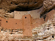 |
NPS National Park Service The National Park Service is the U.S. federal agency that manages all national parks, many national monuments, and other conservation and historical properties with various title designations... |
Arizona Arizona Arizona ; is a state located in the southwestern region of the United States. It is also part of the western United States and the mountain west. The capital and largest city is Phoenix... 34.61°N 111.84°W |
Montezuma Castle features well-preserved cliff dwellings built and used by the Pre-Columbian Pre-Columbian The pre-Columbian era incorporates all period subdivisions in the history and prehistory of the Americas before the appearance of significant European influences on the American continents, spanning the time of the original settlement in the Upper Paleolithic period to European colonization during... Sinagua Sinagua The Sinagua were a pre-Columbian cultural group occupying an area in central Arizona between the Little Colorado River and the Salt River including the Verde Valley and significant portions of the Mogollon Rim country between approximately 500 AD and 1425 AD.Early Sinagua sites consist of pit houses... people around 1400 AD. Several Hopi Hopi The Hopi are a federally recognized tribe of indigenous Native American people, who primarily live on the Hopi Reservation in northeastern Arizona. The Hopi area according to the 2000 census has a population of 6,946 people. Their Hopi language is one of the 30 of the Uto-Aztecan language... clan Clan A clan is a group of people united by actual or perceived kinship and descent. Even if lineage details are unknown, clan members may be organized around a founding member or apical ancestor. The kinship-based bonds may be symbolical, whereby the clan shares a "stipulated" common ancestor that is a... s trace their roots to the area, which is not connected to Montezuma. The monument also includes the Montezuma Well Montezuma Well Montezuma Well , a detached unit of Montezuma Castle National Monument, is a natural limestone sinkhole near Rimrock, Arizona through which some of water flow each day through two underground springs. It is located northeast of Montezuma Castle. The well measures in at across and deep. The... , which has been used for irrigation since the 8th century. |
|
| Mount St. Helens Mount St. Helens National Volcanic Monument Mount St. Helens National Volcanic Monument is a U.S. National Monument that includes the area around Mount St. Helens in Washington. It was established on August 27, 1982 by U.S. President Ronald Reagan following the 1980 eruption of Mount St. Helens. The 110,000 acre National Volcanic... |
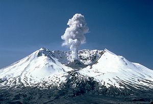 |
USFS | Washington 46.23°N 122.18°W |
Following the 1980 eruption of Mount St. Helens 1980 eruption of Mount St. Helens The 1980 eruption of Mount St. Helens, a stratovolcano located in Washington state, in the United States, was a major volcanic eruption. The eruption was the only significant one to occur in the contiguous 48 U.S. states since the 1915 eruption of Lassen Peak in California... , this area was set aside for research, recreation, and education. The environment is left to respond naturally to the disturbance. |
|
| Muir Woods Muir Woods National Monument Muir Woods National Monument is a unit of the National Park Service on the Pacific coast of southwestern Marin County, California, north of San Francisco and part of the Golden Gate National Recreation Area... |
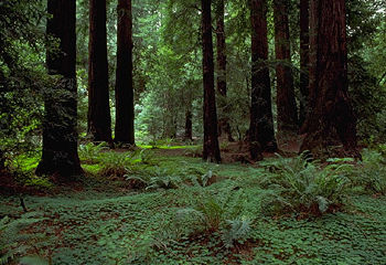 |
NPS National Park Service The National Park Service is the U.S. federal agency that manages all national parks, many national monuments, and other conservation and historical properties with various title designations... |
California California California is a state located on the West Coast of the United States. It is by far the most populous U.S. state, and the third-largest by land area... 37.89°N 122.58°W |
Part of the Golden Gate National Recreation Area Golden Gate National Recreation Area The Golden Gate National Recreation Area is a U.S. National Recreation Area administered by the National Park Service that surrounds the San Francisco Bay area. It is one of the most visited units of the National Park system in the United States, with over 13 million visitors a year... , it protects one of the last old growth Old growth forest An old-growth forest is a forest that has attained great age , and thereby exhibits unique ecological features. An old growth forest has also usually reached a climax community... Coast Redwood (Sequoia sempervirens) groves in the San Francisco Bay Area San Francisco Bay Area The San Francisco Bay Area, commonly known as the Bay Area, is a populated region that surrounds the San Francisco and San Pablo estuaries in Northern California. The region encompasses metropolitan areas of San Francisco, Oakland, and San Jose, along with smaller urban and rural areas... as well as one of the most easily accessed. |
|
| Natural Bridges Natural Bridges National Monument Natural Bridges National Monument is a U.S. National Monument located about north west of the Four Corners boundary of southeast Utah, in the western United States, at the junction of White Canyon and Armstrong Canyon, part of the Colorado River drainage... |
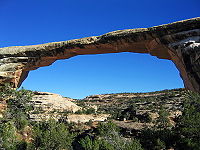 |
NPS National Park Service The National Park Service is the U.S. federal agency that manages all national parks, many national monuments, and other conservation and historical properties with various title designations... |
Utah Utah Utah is a state in the Western United States. It was the 45th state to join the Union, on January 4, 1896. Approximately 80% of Utah's 2,763,885 people live along the Wasatch Front, centering on Salt Lake City. This leaves vast expanses of the state nearly uninhabited, making the population the... 37.58°N 110°W |
Located at the junction of White Canyon and Armstrong Canyon, it is part of the Colorado River Colorado River The Colorado River , is a river in the Southwestern United States and northwestern Mexico, approximately long, draining a part of the arid regions on the western slope of the Rocky Mountains. The watershed of the Colorado River covers in parts of seven U.S. states and two Mexican states... drainage. It features the second- and third-largest natural bridge Natural arch A natural arch or natural bridge is a natural geological formation where a rock arch forms, with an opening underneath. Most natural arches form as a narrow ridge, walled by cliffs, become narrower from erosion, with a softer rock stratum under the cliff-forming stratum gradually eroding out until... s in the world, carved from the white Triassic Triassic The Triassic is a geologic period and system that extends from about 250 to 200 Mya . As the first period of the Mesozoic Era, the Triassic follows the Permian and is followed by the Jurassic. Both the start and end of the Triassic are marked by major extinction events... sandstone of the Cedar Mesa Formation Cedar Mesa Sandstone Cedar Mesa Sandstone is a sandstone member of the Cutler Formation, found in southeast Utah, southwest Colorado, northwest New Mexico, and northeast Arizona. It is the remains of coastal sand dunes deposited about 245–286 million years ago, during the early Permian period... that gives White Canyon its name. |
|
| Navajo Navajo National Monument Navajo National Monument is located within the northwest portion of the Navajo Reservation in northern Arizona.Navajo National Monument preserves three of the most intact cliff dwellings of the ancestral puebloan people . The Navajo people who live here today call these ancient ones Anasazi... |
 |
NPS National Park Service The National Park Service is the U.S. federal agency that manages all national parks, many national monuments, and other conservation and historical properties with various title designations... |
Arizona Arizona Arizona ; is a state located in the southwestern region of the United States. It is also part of the western United States and the mountain west. The capital and largest city is Phoenix... 36.68°N 110.53°W |
This monument preserves three of the most intact cliff dwellings of the Ancestral Puebloan people, the Anasazi. The monument is high on the Shonto plateau, overlooking the Tsegi Canyon system in the Navajo Nation in Northern Arizona. | |
| Newberry Newberry National Volcanic Monument Newberry National Volcanic Monument was designated on November 5, 1990, to protect the area around the Newberry Volcano in the United States. It was created within the boundaries of the Deschutes National Forest and is managed by the U.S. Forest Service... |
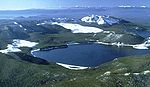 |
USFS | Oregon Oregon Oregon is a state in the Pacific Northwest region of the United States. It is located on the Pacific coast, with Washington to the north, California to the south, Nevada on the southeast and Idaho to the east. The Columbia and Snake rivers delineate much of Oregon's northern and eastern... 43.69°N 121.25°W |
Located within Deschutes National Forest Deschutes National Forest The Deschutes National Forest is a United States National Forest located in parts of Deschutes, Klamath, Lake, and Jefferson counties in central Oregon. It comprises 1.8 million acres along the east side of the Cascade mountains. In 1908, the Deschutes National Forest was established from parts... , the monument protects the area around the Newberry Volcano Newberry Volcano Newberry Volcano is a large potentially active shield volcano located east of the Cascade Range and about southeast of Bend, Oregon. It is not a typical shield volcano. In addition to erupting basaltic lavas, it also has erupted andesitic and even rhyolitic lava.The volcano is in diameter and... and its geologic features. It contains over 50000 acres (202.3 km²) of lakes, lava flows, and other geologic features. |
|
| Ocmulgee Ocmulgee National Monument Ocmulgee National Monument preserves traces of over ten millennia of Southeastern Native American culture, including major earthworks built more than 1,000 years ago by Mississippian culture peoples: the Great Temple and other ceremonial mounds, a burial mound, and defensive trenches... |
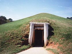 |
NPS National Park Service The National Park Service is the U.S. federal agency that manages all national parks, many national monuments, and other conservation and historical properties with various title designations... |
Georgia Georgia (U.S. state) Georgia is a state located in the southeastern United States. It was established in 1732, the last of the original Thirteen Colonies. The state is named after King George II of Great Britain. Georgia was the fourth state to ratify the United States Constitution, on January 2, 1788... 32.83°N 83.61°W |
Ocmulgee preserves traces of more than 10 millennia of native Southeastern culture, including Mississippian Mississippian culture The Mississippian culture was a mound-building Native American culture that flourished in what is now the Midwestern, Eastern, and Southeastern United States from approximately 800 CE to 1500 CE, varying regionally.... mounds. From Ice Age hunters to the Creek Indians of historic times, there is evidence of at least 10,000 years of human habitation. Between 900 and 1150, an elite society supported by skillful farmers lived on this site near the Ocmulgee River Ocmulgee River The Ocmulgee River is a tributary of the Altamaha River, approximately 255 mi long, in the U.S. state of Georgia... . |
|
| Oregon Caves Oregon Caves National Monument Oregon Caves National Monument is a national monument in the northern Siskiyou Mountains of southwestern Oregon in the United States. The main part of the park, including the marble cave and a visitor center, is located east of Cave Junction, on Oregon Route 46. A separate visitor center in Cave... |
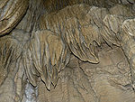 |
NPS National Park Service The National Park Service is the U.S. federal agency that manages all national parks, many national monuments, and other conservation and historical properties with various title designations... |
Oregon Oregon Oregon is a state in the Pacific Northwest region of the United States. It is located on the Pacific coast, with Washington to the north, California to the south, Nevada on the southeast and Idaho to the east. The Columbia and Snake rivers delineate much of Oregon's northern and eastern... 42.10°N 123.41°W |
The monument is known for its marble Marble Marble is a metamorphic rock composed of recrystallized carbonate minerals, most commonly calcite or dolomite.Geologists use the term "marble" to refer to metamorphosed limestone; however stonemasons use the term more broadly to encompass unmetamorphosed limestone.Marble is commonly used for... cave Cave A cave or cavern is a natural underground space large enough for a human to enter. The term applies to natural cavities some part of which is in total darkness. The word cave also includes smaller spaces like rock shelters, sea caves, and grottos.Speleology is the science of exploration and study... s, as well as for the Pleistocene Pleistocene The Pleistocene is the epoch from 2,588,000 to 11,700 years BP that spans the world's recent period of repeated glaciations. The name pleistocene is derived from the Greek and .... jaguar Jaguar The jaguar is a big cat, a feline in the Panthera genus, and is the only Panthera species found in the Americas. The jaguar is the third-largest feline after the tiger and the lion, and the largest in the Western Hemisphere. The jaguar's present range extends from Southern United States and Mexico... and grizzly bear Grizzly Bear The grizzly bear , also known as the silvertip bear, the grizzly, or the North American brown bear, is a subspecies of brown bear that generally lives in the uplands of western North America... fossil Fossil Fossils are the preserved remains or traces of animals , plants, and other organisms from the remote past... s found in the deeper caves. There are four primary buildings: The Oregon Caves Chateau Oregon Caves Chateau The Oregon Caves Chateau is a historic American hotel that opened in 1934. It is located in Oregon Caves National Monument in southern Oregon, near Cave Junction. The Chateau was designed and built by Gust Lium, a local contractor... , The Ranger Residence, The Chalet, and the old Dormitory. |
|
| Organ Pipe Cactus Organ Pipe Cactus National Monument Organ Pipe Cactus National Monument is a U.S. National Monument and UNESCO biosphere reserve located in extreme southern Arizona which shares a border with the Mexican state of Sonora. The park is the only place in the United States where the Organ Pipe Cactus grows wild... |
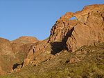 |
NPS National Park Service The National Park Service is the U.S. federal agency that manages all national parks, many national monuments, and other conservation and historical properties with various title designations... |
Arizona Arizona Arizona ; is a state located in the southwestern region of the United States. It is also part of the western United States and the mountain west. The capital and largest city is Phoenix... 32.04°N 112.86°W |
This monument is the only place in the United States where the Organ Pipe Cactus Organ Pipe Cactus The Organ Pipe Cactus is a species of cactus native to Mexico and the United States. The species is found in rocky desert. Two subspecies are recognized based on their distribution and height. The Organ Pipe Cactus National Monument is named for the species.It is locally known as pitahaya dulce,... grows wild. There are many other types of cacti Cactus A cactus is a member of the plant family Cactaceae. Their distinctive appearance is a result of adaptations to conserve water in dry and/or hot environments. In most species, the stem has evolved to become photosynthetic and succulent, while the leaves have evolved into spines... and desert flora native to the Sonoran Desert Sonoran Desert The Sonoran Desert is a North American desert which straddles part of the United States-Mexico border and covers large parts of the U.S. states of Arizona and California and the northwest Mexican states of Sonora, Baja California, and Baja California Sur. It is one of the largest and hottest... . The Bates Well Ranch Bates Well Ranch The Bates Well Ranch , also known as the Bates Well, Growler Well, Gray Ranch and El Veit, was one of the fifteen ranches and line camps in the Gray family cattle business in the Sonoran Desert country north of the US-Mexico border in Pima County, Arizona... and Dos Lomitas Ranch Dos Lomitas Ranch The Dos Lomitas Ranch, also known as the Rattlesnake Ranch, Blankenship Well and the Gray Ranch, was the first of fifteen ranches and line camps in the Gray family cattle business in the Sonoran Desert country north of the US-Mexico border in Arizona. The ranch is now part of Organ Pipe Cactus... are also within the monument. |
|
| Pacific Remote Islands Marine |  |
FWS | United States Minor Outlying Islands United States Minor Outlying Islands The United States Minor Outlying Islands, a statistical designation defined by the International Organization for Standardization's ISO 3166-1 code, consists of nine United States insular areas in the Pacific Ocean and Caribbean Sea: Baker Island, Howland Island, Jarvis Island, Johnston Atoll,... south-southwest of Hawaii |
The marine monument consists of Baker Island Baker Island Baker Island is an uninhabited atoll located just north of the equator in the central Pacific Ocean about southwest of Honolulu. The island lies almost halfway between Hawaii and Australia, and is a possession of the United States. Its nearest neighbor is Howland Island, to the north.Located at... , Howland Island Howland Island Howland Island is an uninhabited coral island located just north of the equator in the central Pacific Ocean, about southwest of Honolulu. The island lies almost halfway between Hawaii and Australia and is an unincorporated, unorganized territory of the United States. Geographically, it is part... , Jarvis Island Jarvis Island Jarvis Island is an uninhabited 4.5 square kilometer coral island located in the South Pacific Ocean at , about halfway between Hawaii and the Cook Islands... , Johnston Atoll Johnston Atoll Johnston Atoll is a atoll in the North Pacific Ocean about west of Hawaii. There are four islands located on the coral reef platform, two natural islands, Johnston Island and Sand Island, which have been expanded by coral dredging, as well as North Island and East Island , an additional two... , Kingman Reef Kingman Reef Kingman Reef is a largely submerged, uninhabited triangular shaped reef, east-west and north-south, located in the North Pacific Ocean, roughly half way between the Hawaiian Islands and American Samoa at... , Palmyra Atoll Palmyra Atoll Palmyra Atoll is an essentially unoccupied equatorial Northern Pacific atoll administered as an unorganized incorporated territory by the United States federal government... , and Wake Island Wake Island Wake Island is a coral atoll having a coastline of in the North Pacific Ocean, located about two-thirds of the way from Honolulu west to Guam east. It is an unorganized, unincorporated territory of the United States, administered by the Office of Insular Affairs, U.S. Department of the Interior... , which are in the Pacific southwest of Hawaii. |
|
| Papahānaumokuākea Marine | 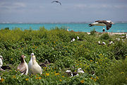 |
NOAA National Oceanic and Atmospheric Administration The National Oceanic and Atmospheric Administration , pronounced , like "noah", is a scientific agency within the United States Department of Commerce focused on the conditions of the oceans and the atmosphere... , FWS |
Hawaii Hawaii Hawaii is the newest of the 50 U.S. states , and is the only U.S. state made up entirely of islands. It is the northernmost island group in Polynesia, occupying most of an archipelago in the central Pacific Ocean, southwest of the continental United States, southeast of Japan, and northeast of... 25.7°N 171.73°W |
Encompassing 140000 mi2 of ocean waters and 10 islands and atolls of the Northwestern Hawaiian Islands Northwestern Hawaiian Islands The Northwestern Hawaiian Islands or the Leeward Islands are the small islands and atolls in the Hawaiian island chain located northwest of the islands of Kauai and Niihau. They are administered by the U.S. state of Hawaii except Midway Atoll, which has temporary residential facilities and is... , it is the largest Marine Protected Area Marine Protected Area Marine Protected Areas, like any protected area, are regions in which human activity has been placed under some restrictions in the interest of conserving the natural environment, it's surrounding waters and the occupant ecosystems, and any cultural or historical resources that may require... in the world. It is larger than 46 states as well as 7 times larger than all other national marine sanctuaries combined. |
|
| Petroglyph Petroglyph National Monument Petroglyph National Monument stretches along Albuquerque, New Mexico's West Mesa, a volcanic basalt escarpment that dominates the city’s western horizon. Authorized June 27, 1990, the 7,236 acre monument is cooperatively managed by the National Park Service and the City of Albuquerque... |
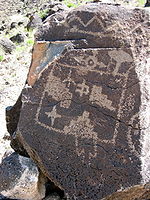 |
NPS National Park Service The National Park Service is the U.S. federal agency that manages all national parks, many national monuments, and other conservation and historical properties with various title designations... |
New Mexico New Mexico New Mexico is a state located in the southwest and western regions of the United States. New Mexico is also usually considered one of the Mountain States. With a population density of 16 per square mile, New Mexico is the sixth-most sparsely inhabited U.S... 35.16°N 106.76°W |
This monument protects a variety of cultural and natural resources, including five volcanic cones, hundreds of archeological sites and an estimated 25,000 images carved by native peoples and early Spanish settlers. It lies on West Mesa West Mesa right|300px|thumb|View of downtown Albuquerque and the Manzano Mountains from the West MesaThe West Mesa is an elevated landmass lying west of the Rio Grande River stretching from south of Albuquerque northward to Bernalillo in the U.S. state of New Mexico. The eastern edge of the West Mesa is... , a volcanic basalt Basalt Basalt is a common extrusive volcanic rock. It is usually grey to black and fine-grained due to rapid cooling of lava at the surface of a planet. It may be porphyritic containing larger crystals in a fine matrix, or vesicular, or frothy scoria. Unweathered basalt is black or grey... escarpment Escarpment An escarpment is a steep slope or long cliff that occurs from erosion or faulting and separates two relatively level areas of differing elevations.-Description and variants:... . |
|
| Pinnacles Pinnacles National Monument Pinnacles National Monument is a protected mountainous area located east of central California's Salinas Valley, just miles from the town of Soledad... |
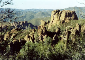 |
NPS National Park Service The National Park Service is the U.S. federal agency that manages all national parks, many national monuments, and other conservation and historical properties with various title designations... |
California California California is a state located on the West Coast of the United States. It is by far the most populous U.S. state, and the third-largest by land area... 36.48°N 121.16°W |
Known for the namesake eroded Erosion Erosion is when materials are removed from the surface and changed into something else. It only works by hydraulic actions and transport of solids in the natural environment, and leads to the deposition of these materials elsewhere... leftovers of half of an extinct volcano Volcano 2. Bedrock3. Conduit 4. Base5. Sill6. Dike7. Layers of ash emitted by the volcano8. Flank| 9. Layers of lava emitted by the volcano10. Throat11. Parasitic cone12. Lava flow13. Vent14. Crater15... , it is popular for its rock climbing Rock climbing Rock climbing also lightly called 'The Gravity Game', is a sport in which participants climb up, down or across natural rock formations or artificial rock walls. The goal is to reach the summit of a formation or the endpoint of a pre-defined route without falling... . |
|
| Pipe Spring Pipe Spring National Monument Pipe Spring National Monument is located in the U.S. state of Arizona, and is rich with American Indian, early explorer, and Mormon pioneer history... |
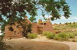 |
NPS National Park Service The National Park Service is the U.S. federal agency that manages all national parks, many national monuments, and other conservation and historical properties with various title designations... |
Arizona Arizona Arizona ; is a state located in the southwestern region of the United States. It is also part of the western United States and the mountain west. The capital and largest city is Phoenix... 36.86°N 112.73°W |
Rich with American Indian Native Americans in the United States Native Americans in the United States are the indigenous peoples in North America within the boundaries of the present-day continental United States, parts of Alaska, and the island state of Hawaii. They are composed of numerous, distinct tribes, states, and ethnic groups, many of which survive as... , early explorer and Mormon pioneer Mormon Pioneer The Mormon pioneers were members of The Church of Jesus Christ of Latter-day Saints, also known as Latter-day Saints, who migrated across the United States from the Midwest to the Salt Lake Valley in what is today the U.S. state of Utah... history, this site shows Ancestral Puebloans and Kaibab Paiute Paiute Paiute refers to three closely related groups of Native Americans — the Northern Paiute of California, Idaho, Nevada and Oregon; the Owens Valley Paiute of California and Nevada; and the Southern Paiute of Arizona, southeastern California and Nevada, and Utah.-Origin of name:The origin of... Indian and pioneer Settler A settler is a person who has migrated to an area and established permanent residence there, often to colonize the area. Settlers are generally people who take up residence on land and cultivate it, as opposed to nomads... life in the Old West, including the cabin where explorer John Wesley Powell John Wesley Powell John Wesley Powell was a U.S. soldier, geologist, explorer of the American West, and director of major scientific and cultural institutions... 's survey crew stayed in 1871. The water of Pipe Spring, discovered in 1858, made it possible for plants, animals, and people to live in this dry desert region. |
|
| Pipestone Pipestone National Monument Pipestone National Monument is located in southwestern Minnesota, just north of the city of Pipestone, Minnesota. It is located along the highways of U.S. Route 75, Minnesota State Highway 23 and Minnesota State Highway 30.... |
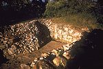 |
NPS National Park Service The National Park Service is the U.S. federal agency that manages all national parks, many national monuments, and other conservation and historical properties with various title designations... |
Minnesota Minnesota Minnesota is a U.S. state located in the Midwestern United States. The twelfth largest state of the U.S., it is the twenty-first most populous, with 5.3 million residents. Minnesota was carved out of the eastern half of the Minnesota Territory and admitted to the Union as the thirty-second state... 44.01°N 96.33°W |
This monument preserves traditional catlinite Catlinite Catlinite is a type of argillite , usually brownish-red in color, which occurs in a matrix of Sioux quartzite. Because it is fine-grained and easily worked, it is prized by Native Americans for use in making sacred pipes such as calumets and chanunpas... quarries Quarry A quarry is a type of open-pit mine from which rock or minerals are extracted. Quarries are generally used for extracting building materials, such as dimension stone, construction aggregate, riprap, sand, and gravel. They are often collocated with concrete and asphalt plants due to the requirement... used to make ceremonial peace pipes, vitally important to traditional Plains Indian Plains Indians The Plains Indians are the Indigenous peoples who live on the plains and rolling hills of the Great Plains of North America. Their colorful equestrian culture and resistance to White domination have made the Plains Indians an archetype in literature and art for American Indians everywhere.Plains... culture. The quarries are sacred to the Sioux Sioux The Sioux are Native American and First Nations people in North America. The term can refer to any ethnic group within the Great Sioux Nation or any of the nation's many language dialects... and Sioux and were neutral territory where all tribes could quarry the stone. |
|
| Pompeys Pillar Pompeys Pillar National Monument Pompeys Pillar National Monument is a rock formation located in south central Montana, United States. Designated a National Monument on January 17, 2001, and managed by the U.S. Bureau of Land Management, it consists of only , making it one of the smallest National Monuments in the U.S... |
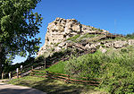 |
BLM Bureau of Land Management The Bureau of Land Management is an agency within the United States Department of the Interior which administers America's public lands, totaling approximately , or one-eighth of the landmass of the country. The BLM also manages of subsurface mineral estate underlying federal, state and private... |
Montana Montana Montana is a state in the Western United States. The western third of Montana contains numerous mountain ranges. Smaller, "island ranges" are found in the central third of the state, for a total of 77 named ranges of the Rocky Mountains. This geographical fact is reflected in the state's name,... 45.99°N 108.001°W |
Pompeys Pillar is a 150 feet (45.7 m) sandstone Sandstone Sandstone is a sedimentary rock composed mainly of sand-sized minerals or rock grains.Most sandstone is composed of quartz and/or feldspar because these are the most common minerals in the Earth's crust. Like sand, sandstone may be any colour, but the most common colours are tan, brown, yellow,... pillar from the late Cretaceous Cretaceous The Cretaceous , derived from the Latin "creta" , usually abbreviated K for its German translation Kreide , is a geologic period and system from circa to million years ago. In the geologic timescale, the Cretaceous follows the Jurassic period and is followed by the Paleogene period of the... Hell Creek Formation Hell Creek Formation The Hell Creek Formation is an intensely-studied division of Upper Cretaceous to lower Paleocene rocks in North America, named for exposures studied along Hell Creek, near Jordan, Montana... next to the Yellowstone River Yellowstone River The Yellowstone River is a tributary of the Missouri River, approximately long, in the western United States. Considered the principal tributary of the upper Missouri, the river and its tributaries drain a wide area stretching from the Rocky Mountains in the vicinity of the Yellowstone National... . It has an abundance of Native American Native Americans in the United States Native Americans in the United States are the indigenous peoples in North America within the boundaries of the present-day continental United States, parts of Alaska, and the island state of Hawaii. They are composed of numerous, distinct tribes, states, and ethnic groups, many of which survive as... petroglyph Petroglyph Petroglyphs are pictogram and logogram images created by removing part of a rock surface by incising, picking, carving, and abrading. Outside North America, scholars often use terms such as "carving", "engraving", or other descriptions of the technique to refer to such images... s, as well as the signature of William Clark, who named the formation after Sacagawea Sacagawea Sacagawea ; was a Lemhi Shoshone woman, who accompanied the Lewis and Clark Expedition, acting as an interpreter and guide, in their exploration of the Western United States... 's infant son. |
|
| Poverty Point |  |
NPS National Park Service The National Park Service is the U.S. federal agency that manages all national parks, many national monuments, and other conservation and historical properties with various title designations... |
Louisiana Louisiana Louisiana is a state located in the southern region of the United States of America. Its capital is Baton Rouge and largest city is New Orleans. Louisiana is the only state in the U.S. with political subdivisions termed parishes, which are local governments equivalent to counties... 32.63°N 91.41°W |
Poverty Point is a prehistoric archeological site that dates from between 1650 and 700 BC and consisting of six earthen rings and seven mounds. The diameter of the outside ridge is 0.75 miles (1.2 km), and the largest mound rises 51 feet (15.5 m). | |
| Prehistoric Trackways Prehistoric Trackways National Monument Prehistoric Trackways National Monument is the 100th national monument in The United States of America. The monument is located in the Robledo Mountains, near Las Cruces in the southern region of the U.S. state of New Mexico... |
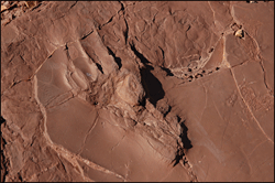 |
BLM Bureau of Land Management The Bureau of Land Management is an agency within the United States Department of the Interior which administers America's public lands, totaling approximately , or one-eighth of the landmass of the country. The BLM also manages of subsurface mineral estate underlying federal, state and private... |
New Mexico New Mexico New Mexico is a state located in the southwest and western regions of the United States. New Mexico is also usually considered one of the Mountain States. With a population density of 16 per square mile, New Mexico is the sixth-most sparsely inhabited U.S... 32.35°N 106.9°W |
Prehistoric Trackways contains fossilized footprints of numerous Paleozoic amphibians, reptiles, and insects, as well as fossilized plants and petrified wood dating back approximately 280 million years. (Public Law No. 111-11) | |
| President Lincoln and Soldiers' Home President Lincoln's Cottage at the Soldiers' Home President Lincoln's Cottage is a national monument on the grounds of the Soldiers' Home, known today as the Armed Forces Retirement Home. It is located in the Petworth and Park View neighborhoods of Washington, D.C.... |
 |
AFRH Armed Forces Retirement Home The Armed Forces Retirement Home , formerly the U.S. Soldiers' and Airmen's Home, the U.S. Soldiers' Home, and the U.S. Military Asylum, is an independent establishment in the executive branch of the federal government of the United States... |
District of Columbia 38.9416°N 77.0117°W |
President Abraham Lincoln and his family resided seasonally on the grounds of the United States Soldiers' and Airmen's Home, which was founded in 1851 for homeless and disabled war veterans. The home is co-managed by the National Trust for Historic Preservation National Trust for Historic Preservation The National Trust for Historic Preservation is an American member-supported organization that was founded in 1949 by congressional charter to support preservation of historic buildings and neighborhoods through a range of programs and activities, including the publication of Preservation... . |
|
| Rainbow Bridge Rainbow Bridge National Monument Rainbow Bridge National Monument is administered by Glen Canyon National Recreation Area, southern Utah, USA. Rainbow Bridge is often described as the world's highest natural bridge. The span of Rainbow Bridge was reported in 1974 by the Bureau of Reclamation to be , but a laser measurement in... |
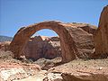 |
NPS National Park Service The National Park Service is the U.S. federal agency that manages all national parks, many national monuments, and other conservation and historical properties with various title designations... |
Utah Utah Utah is a state in the Western United States. It was the 45th state to join the Union, on January 4, 1896. Approximately 80% of Utah's 2,763,885 people live along the Wasatch Front, centering on Salt Lake City. This leaves vast expanses of the state nearly uninhabited, making the population the... 37.08°N 110.96°W |
One of the largest in the world, Rainbow Bridge is the most famous example of a natural bridge Natural Bridge Natural bridge or Natural Bridge can refer to several things:*Natural arch, a land formation sometimes referred to as a natural bridge*Natural Bridge, Alabama*Natural Bridge, New York... as well as the most accessible. It stands 290 feet (88.4 m) tall and spans 275 feet (83.8 m) wide; the top of the bridge is 42 feet (12.8 m) thick and 33 feet (10.1 m) wide. It was made from sandstone Sandstone Sandstone is a sedimentary rock composed mainly of sand-sized minerals or rock grains.Most sandstone is composed of quartz and/or feldspar because these are the most common minerals in the Earth's crust. Like sand, sandstone may be any colour, but the most common colours are tan, brown, yellow,... formed during the Triassic Triassic The Triassic is a geologic period and system that extends from about 250 to 200 Mya . As the first period of the Mesozoic Era, the Triassic follows the Permian and is followed by the Jurassic. Both the start and end of the Triassic are marked by major extinction events... and the Jurassic Jurassic The Jurassic is a geologic period and system that extends from about Mya to Mya, that is, from the end of the Triassic to the beginning of the Cretaceous. The Jurassic constitutes the middle period of the Mesozoic era, also known as the age of reptiles. The start of the period is marked by... periods. |
|
| Rose Atoll Marine | 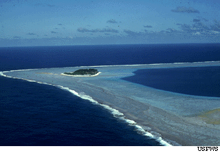 |
FWS | American Samoa American Samoa American Samoa is an unincorporated territory of the United States located in the South Pacific Ocean, southeast of the sovereign state of Samoa... 14.55°N 168.54°W |
This marine monument consists of the two small islands of Rose Atoll Rose Atoll Rose Atoll, sometimes called Rose Island or Motu O Manu by people of the nearby Manu'a Islands, is an oceanic atoll within the U.S. territory of American Samoa. It is an uninhabited wildlife refuge. It is the southernmost point in the United States. The land area is 0.214 km²... , a lagoon, and a coral reef east of American Samoa. It is the southernmost point in the U.S. Extreme points of the United States This is a list of the extreme points of the United States, the points that are farther north, south, east, or west than any other location in the country. Also included are extreme points in elevation, extreme distances, and other points of peculiar geographic interest.-Northernmost:*Point Barrow,... . |
|
| Russell Cave Russell Cave National Monument The Russell Cave National Monument is a U.S. National Monument in northeastern Alabama, United States, close to the town of Bridgeport. The Monument was established on May 11, 1961, when 310 acres of land were donated by the National Geographic Society to the American people. It is now... |
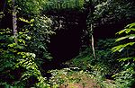 |
NPS National Park Service The National Park Service is the U.S. federal agency that manages all national parks, many national monuments, and other conservation and historical properties with various title designations... |
Alabama Alabama Alabama is a state located in the southeastern region of the United States. It is bordered by Tennessee to the north, Georgia to the east, Florida and the Gulf of Mexico to the south, and Mississippi to the west. Alabama ranks 30th in total land area and ranks second in the size of its inland... 34.97°N 85.80°W |
Donated by the National Geographic Society National Geographic Society The National Geographic Society , headquartered in Washington, D.C. in the United States, is one of the largest non-profit scientific and educational institutions in the world. Its interests include geography, archaeology and natural science, the promotion of environmental and historical... , the cave's exceptionally large main entrance was used as a shelter by prehistoric Prehistory Prehistory is the span of time before recorded history. Prehistory can refer to the period of human existence before the availability of those written records with which recorded history begins. More broadly, it refers to all the time preceding human existence and the invention of writing... Indians from the earliest known human settlement in the southeastern United States. The rock from which Russell Cave was formed over 300 million years ago at the bottom of an inland sea that covers the region. |
|
| Salinas Pueblo Missions Salinas Pueblo Missions National Monument The Salinas Pueblo Missions National Monument is located in the U.S. state of New Mexico, near Mountainair. The main park visitor center is in Mountainair.-History:... |
NPS National Park Service The National Park Service is the U.S. federal agency that manages all national parks, many national monuments, and other conservation and historical properties with various title designations... |
New Mexico New Mexico New Mexico is a state located in the southwest and western regions of the United States. New Mexico is also usually considered one of the Mountain States. With a population density of 16 per square mile, New Mexico is the sixth-most sparsely inhabited U.S... 34.26°N 106.06°W |
Formerly known as Gran Quivira National Monument, it is where Native American Native Americans in the United States Native Americans in the United States are the indigenous peoples in North America within the boundaries of the present-day continental United States, parts of Alaska, and the island state of Hawaii. They are composed of numerous, distinct tribes, states, and ethnic groups, many of which survive as... trade communities of Tiwa- and Tompiro-speaking Puebloans lived when Spanish Franciscan Franciscan Most Franciscans are members of Roman Catholic religious orders founded by Saint Francis of Assisi. Besides Roman Catholic communities, there are also Old Catholic, Anglican, Lutheran, ecumenical and Non-denominational Franciscan communities.... missionaries made contact in the 17th century. What remains are the ruins of four mission churches, at Quarai, Abó, and Gran Quivira, and the partially excavated pueblo of Las Humanas. |
||
| Santa Rosa and San Jacinto Mountains Santa Rosa and San Jacinto Mountains National Monument The Santa Rosa and San Jacinto Mountains National Monument is a National Monument in Southern California. It includes portions of the Santa Rosa and San Jacinto Mountain ranges, the northernmost ones of the Peninsular Ranges system... |
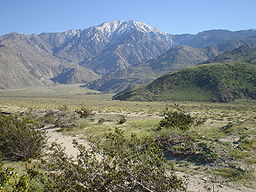 |
BLM Bureau of Land Management The Bureau of Land Management is an agency within the United States Department of the Interior which administers America's public lands, totaling approximately , or one-eighth of the landmass of the country. The BLM also manages of subsurface mineral estate underlying federal, state and private... , USFS |
California California California is a state located on the West Coast of the United States. It is by far the most populous U.S. state, and the third-largest by land area... 33.80°N 116.70°W |
This monument preserves large portions of the Santa Rosa Santa Rosa Mountains (California) The Santa Rosa Mountains are a short mountain range in the Peninsular Ranges system, located east of the Los Angeles Basin and northeast of the San Diego metropolitan area of southern California, in the Southwestern United States.-Geography:... and San Jacinto San Jacinto Mountains The San Jacinto Mountains are a mountain range east of Los Angeles in southern California in the United States. The mountains are named for Saint Hyacinth . The Pacific Crest Trail runs along the spine of the range.The range extends for approximately from the San Bernardino Mountains southeast to... ranges, the northernmost of the Peninsular Ranges Peninsular Ranges The Peninsular Ranges are a group of mountain ranges, in the Pacific Coast Ranges, which stretch from southern California in the United States to the southern tip of Mexico's Baja California peninsula; they are part of the North American Coast Ranges that run along the Pacific coast from Alaska... . Parts are within San Bernardino National Forest San Bernardino National Forest San Bernardino National Forest is a federally-managed forest covering more than 800,000 acres . There are two main divisions which are the San Bernardino Mountains on the easternmost of the Transverse Range, and the San Jacinto and Santa Rosa Mountains on the northernmost of the Peninsular... and the California Desert Conservation Area. |
|
| Scotts Bluff Scotts Bluff National Monument Scotts Bluff National Monument in western Nebraska includes an important 19th century landmark on the Oregon Trail and Mormon Trail. The National Monument contains multiple bluffs located on the south side of the North Platte River; it is named for one prominent bluff called Scotts Bluff, which... |
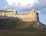 |
NPS National Park Service The National Park Service is the U.S. federal agency that manages all national parks, many national monuments, and other conservation and historical properties with various title designations... |
Nebraska Nebraska Nebraska is a state on the Great Plains of the Midwestern United States. The state's capital is Lincoln and its largest city is Omaha, on the Missouri River.... 41.83°N 103.70°W |
Scotts Bluff is an important 19th century geologic formation and landmark on the Oregon Trail Oregon Trail The Oregon Trail is a historic east-west wagon route that connected the Missouri River to valleys in Oregon and locations in between.After 1840 steam-powered riverboats and steamboats traversing up and down the Ohio, Mississippi and Missouri rivers sped settlement and development in the flat... and Mormon Trail. It contains multiple bluffs on the south side of the North Platte River North Platte River The North Platte River is a major tributary of the Platte River and is approximately long counting its many curves, It travels about distance. Its course lies in the U.S... , but it is named after a prominent bluff called Scotts Bluff which rises more than 830 feet (253 m) above the plains at its highest point. The monument is composed of five rock formations named Crown Rock, Dome Rock, Eagle Rock, Saddle Rock, and Sentinel Rock. |
|
| Sonoran Desert Sonoran Desert National Monument Sonoran Desert National Monument is located south of Goodyear and Buckeye and east of Gila Bend, Arizona. Created by Presidential proclamation on January 17, 2001, the 496,337 acre monument is managed by the U.S. Bureau of Land Management , an agency within the U.S. Department of the... |
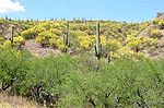 |
BLM Bureau of Land Management The Bureau of Land Management is an agency within the United States Department of the Interior which administers America's public lands, totaling approximately , or one-eighth of the landmass of the country. The BLM also manages of subsurface mineral estate underlying federal, state and private... |
Arizona Arizona Arizona ; is a state located in the southwestern region of the United States. It is also part of the western United States and the mountain west. The capital and largest city is Phoenix... 33.00°N 112.46°W |
This monument protects a small portion of the Sonoran Desert Sonoran Desert The Sonoran Desert is a North American desert which straddles part of the United States-Mexico border and covers large parts of the U.S. states of Arizona and California and the northwest Mexican states of Sonora, Baja California, and Baja California Sur. It is one of the largest and hottest... . It is home to several federally-listed endangered species and also has three wilderness areas, many significant archeological and historic sites, and remnants of several important historic trails. |
|
| Statue of Liberty | 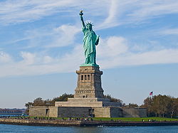 |
NPS National Park Service The National Park Service is the U.S. federal agency that manages all national parks, many national monuments, and other conservation and historical properties with various title designations... |
New York New York New York is a state in the Northeastern region of the United States. It is the nation's third most populous state. New York is bordered by New Jersey and Pennsylvania to the south, and by Connecticut, Massachusetts and Vermont to the east... , New Jersey New Jersey New Jersey is a state in the Northeastern and Middle Atlantic regions of the United States. , its population was 8,791,894. It is bordered on the north and east by the state of New York, on the southeast and south by the Atlantic Ocean, on the west by Pennsylvania and on the southwest by Delaware... 40.69°N 74.04°W |
This iconic statue, built in 1886 on Liberty Island Liberty Island Liberty Island is a small uninhabited island in New York Harbor in the United States, best known as the location of the Statue of Liberty. Though so called since the turn of the century, the name did not become official until 1956. In 1937, by proclamation 2250, President Franklin D... and 151 feet (46 m) tall, commemorates the centennial of the signing of the United States Declaration of Independence United States Declaration of Independence The Declaration of Independence was a statement adopted by the Continental Congress on July 4, 1776, which announced that the thirteen American colonies then at war with Great Britain regarded themselves as independent states, and no longer a part of the British Empire. John Adams put forth a... and is a gesture of friendship from France to the U.S. Liberty Enlighening the World is a symbol of welcoming immigrants to the U.S. and is listed as a World Heritage Site World Heritage Site A UNESCO World Heritage Site is a place that is listed by the UNESCO as of special cultural or physical significance... . Ellis Island Ellis Island Ellis Island in New York Harbor was the gateway for millions of immigrants to the United States. It was the nation's busiest immigrant inspection station from 1892 until 1954. The island was greatly expanded with landfill between 1892 and 1934. Before that, the much smaller original island was the... , where 12 million immigrants entering the U.S. passed through, is included in the monument. |
|
| Sunset Crater Volcano Sunset Crater Sunset Crater is a volcanic cinder cone located north of Flagstaff in U.S. State of Arizona. The crater is within the Sunset Crater Volcano National Monument.... |
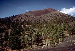 |
NPS National Park Service The National Park Service is the U.S. federal agency that manages all national parks, many national monuments, and other conservation and historical properties with various title designations... |
Arizona Arizona Arizona ; is a state located in the southwestern region of the United States. It is also part of the western United States and the mountain west. The capital and largest city is Phoenix... 35.36°N 111.50°W |
Sunset Crater is the youngest in a string of volcanoes in the San Francisco volcanic field San Francisco volcanic field The San Francisco volcanic field is an area of volcanoes in northern Arizona, north of Flagstaff, USA. The field covers 1,800 square miles of the southern boundary of the Colorado Plateau. The field contains 600 volcanoes ranging in age from less than 6 million years old to less than 1,000 years ,... that is related to the nearby San Francisco Peaks San Francisco Peaks The San Francisco Peaks are a volcanic mountain range located in north central Arizona, just north of Flagstaff.The highest summit in the range, Humphreys Peak, is the highest point in the state of Arizona at in elevation. The San Francisco Peaks are the remains of an eroded stratovolcano... . Final volcanic activity in the 13th century painted the upper portion of the cone with bright red and orange rocks, giving the volcano its name. |
|
| Timpanogos Cave Timpanogos Cave National Monument Timpanogos Cave National Monument is a cave system in the Wasatch mountains in American Fork Canyon near American Fork, Utah, in the United States. The 1.5 mile trail to the cave is steep at several points, but paved and wide, so the cave opening is accessible to most... |
NPS National Park Service The National Park Service is the U.S. federal agency that manages all national parks, many national monuments, and other conservation and historical properties with various title designations... |
Utah Utah Utah is a state in the Western United States. It was the 45th state to join the Union, on January 4, 1896. Approximately 80% of Utah's 2,763,885 people live along the Wasatch Front, centering on Salt Lake City. This leaves vast expanses of the state nearly uninhabited, making the population the... 40.44°N 111.71°W |
The Timpanogos cave system is in the Wasatch Range Wasatch Range The Wasatch Range is a mountain range that stretches approximately from the Utah-Idaho border, south through central Utah in the western United States. It is generally considered the western edge of the greater Rocky Mountains, and the eastern edge of the Great Basin region... in the American Fork Canyon American Fork Canyon American Fork Canyon is a canyon located in the Wasatch Mountains of Utah. The canyon is famous for the Timpanogos Cave National Monument, which resides on its south side... . Three main chambers are accessible: Hansen Cave, Middle Cave, and Timpanogos Cave. Many colorful cave features or speleothem Speleothem A speleothem , commonly known as a cave formation, is a secondary mineral deposit formed in a cave. Speleothems are typically formed in limestone or dolostone solutional caves.-Origin and composition:... s can be seen, including helictites, cave bacon, cave columns, flowstone Flowstone Flowstones are composed of sheetlike deposits of calcite formed where water flows down the walls or along the floors of a cave. They are typically found in "solution", or limestone caves, where they are the most common speleothem. However, they may form in any type of cave where water enters that... , cave popcorn Cave popcorn Cave popcorn, or cave coral, is a very common cave formation. It actually comes in many sizes, shapes, and colors, but is most often found in small, knobby clusters resembling popcorn... , and cave drapery. |
||
| Tonto Tonto National Monument Tonto National Monument is a National Monument in central Arizona, United States. The area lies on the northeastern edge of the Sonoran Desert, which is generally arid land with annual rainfall of about 16 inches here... |
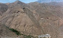 |
NPS National Park Service The National Park Service is the U.S. federal agency that manages all national parks, many national monuments, and other conservation and historical properties with various title designations... |
Arizona Arizona Arizona ; is a state located in the southwestern region of the United States. It is also part of the western United States and the mountain west. The capital and largest city is Phoenix... 33.65°N 111.09°W |
Lying on the northeastern edge of the Sonoran Desert Sonoran Desert The Sonoran Desert is a North American desert which straddles part of the United States-Mexico border and covers large parts of the U.S. states of Arizona and California and the northwest Mexican states of Sonora, Baja California, and Baja California Sur. It is one of the largest and hottest... along the Salt River Salt River (Arizona) The Salt River is a stream in the U.S. state of Arizona. It is the largest tributary of the Gila River. The river is about long. Its drainage basin is about large. The longest of the Salt River's many tributaries is the Verde River... , Tonto preserves two cliff dwellings that were occupied by the Salado culture during the 13th to 15th centuries. The monument is surrounded by Tonto National Forest Tonto National Forest The Tonto National Forest, encompassing 2,873,200 acres , is the largest of the six national forests in Arizona and is the fifth largest national forest in the United States. The Tonto National Forest has diverse scenery, with elevations ranging from 1,400 feet in the Sonoran Desert to 7,400 feet... . |
|
| Tuzigoot Tuzigoot National Monument Tuzigoot National Monument preserves a 2 to 3 story pueblo ruin on the summit of a limestone and sandstone ridge just east of Clarkdale, Arizona, 120 feet above the Verde River floodplain. The pueblo has 110 rooms... |
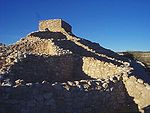 |
NPS National Park Service The National Park Service is the U.S. federal agency that manages all national parks, many national monuments, and other conservation and historical properties with various title designations... |
Arizona Arizona Arizona ; is a state located in the southwestern region of the United States. It is also part of the western United States and the mountain west. The capital and largest city is Phoenix... 34.79°N 112.04°W |
Tuzigoot preserves a two- to three-story pueblo Pueblo Pueblo is a term used to describe modern communities of Native Americans in the Southwestern United States of America. The first Spanish explorers of the Southwest used this term to describe the communities housed in apartment-like structures built of stone, adobe mud, and other local material... ruin on the summit of a limestone and sandstone ridge in the Verde Valley Verde Valley The Verde Valley is a valley in central Arizona in the United States of America. The Verde River runs through it. It is overlooked by Mingus Mountain and the Mogollon Rim.- History :The first notice of this region appears in the report of one Espejo,... . It was built by the Sinagua Sinagua The Sinagua were a pre-Columbian cultural group occupying an area in central Arizona between the Little Colorado River and the Salt River including the Verde Valley and significant portions of the Mogollon Rim country between approximately 500 AD and 1425 AD.Early Sinagua sites consist of pit houses... people between 1125 and 1400. |
|
| Upper Missouri River Breaks Upper Missouri River Breaks National Monument This article is about the location. For the film, see The Missouri Breaks.The Missouri Breaks is located in central Montana, U.S. and is managed by the U.S. Bureau of Land Management under the full title of Upper Missouri River Breaks National Monument... |
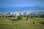 |
BLM Bureau of Land Management The Bureau of Land Management is an agency within the United States Department of the Interior which administers America's public lands, totaling approximately , or one-eighth of the landmass of the country. The BLM also manages of subsurface mineral estate underlying federal, state and private... |
Montana Montana Montana is a state in the Western United States. The western third of Montana contains numerous mountain ranges. Smaller, "island ranges" are found in the central third of the state, for a total of 77 named ranges of the Rocky Mountains. This geographical fact is reflected in the state's name,... 47.78°N 109.02°W |
A series of badland areas characterized by rock outcroppings, steep bluffs and grassy plains along the 149 miles (239.8 km) Upper Missouri National Wild and Scenic River Missouri River The Missouri River flows through the central United States, and is a tributary of the Mississippi River. It is the longest river in North America and drains the third largest area, though only the thirteenth largest by discharge. The Missouri's watershed encompasses most of the American Great... in central Montana, The Breaks is home to at least 60 mammal species and hundreds of bird species. Charles Marion Russell Charles Marion Russell Charles Marion Russell , also known as C. M. Russell, Charlie Russell, and "Kid" Russell, was an artist of the Old American West. Russell created more than 2,000 paintings of cowboys, Indians, and landscapes set in the Western United States, in addition to bronze sculptures... often painted here, and Lewis and Clark traveled on this pathway. |
|
| Vermilion Cliffs Vermilion Cliffs National Monument Vermilion Cliffs National Monument is located in Arizona, immediately south of the Utah state line. This National Monument, 294,000 acre in area, protects the Paria Plateau, Vermilion Cliffs, Coyote Buttes, and Paria Canyon... |
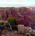 |
BLM Bureau of Land Management The Bureau of Land Management is an agency within the United States Department of the Interior which administers America's public lands, totaling approximately , or one-eighth of the landmass of the country. The BLM also manages of subsurface mineral estate underlying federal, state and private... |
Arizona Arizona Arizona ; is a state located in the southwestern region of the United States. It is also part of the western United States and the mountain west. The capital and largest city is Phoenix... 36.81°N 111.74°W |
Steep eroded escarpments consisting primarily of sandstone Sandstone Sandstone is a sedimentary rock composed mainly of sand-sized minerals or rock grains.Most sandstone is composed of quartz and/or feldspar because these are the most common minerals in the Earth's crust. Like sand, sandstone may be any colour, but the most common colours are tan, brown, yellow,... , siltstone Siltstone Siltstone is a sedimentary rock which has a grain size in the silt range, finer than sandstone and coarser than claystones.- Description :As its name implies, it is primarily composed of silt sized particles, defined as grains 1/16 - 1/256 mm or 4 to 8 on the Krumbein phi scale... , limestone Limestone Limestone is a sedimentary rock composed largely of the minerals calcite and aragonite, which are different crystal forms of calcium carbonate . Many limestones are composed from skeletal fragments of marine organisms such as coral or foraminifera.... and shale Shale Shale is a fine-grained, clastic sedimentary rock composed of mud that is a mix of flakes of clay minerals and tiny fragments of other minerals, especially quartz and calcite. The ratio of clay to other minerals is variable. Shale is characterized by breaks along thin laminae or parallel layering... rise as much as 3000 feet (914.4 m) above their base. These sedimentary rocks have been deeply eroded for millions of years, exposing hundreds of layers of richly colored rock strata. The monument protects Paria Plateau, Vermilion Cliffs, Coyote Buttes and Paria Canyon. |
|
| Virgin Islands Coral Reef Virgin Islands Coral Reef National Monument The Virgin Islands Coral Reef National Monument is a U.S. National Monument located off Saint John, Virgin Islands.The clear waters surrounding Saint John support a diverse and complex system of coral reefs... |
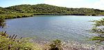 |
NPS National Park Service The National Park Service is the U.S. federal agency that manages all national parks, many national monuments, and other conservation and historical properties with various title designations... |
Virgin Islands United States Virgin Islands The Virgin Islands of the United States are a group of islands in the Caribbean that are an insular area of the United States. The islands are geographically part of the Virgin Islands archipelago and are located in the Leeward Islands of the Lesser Antilles.The U.S... 18.31°N 64.72°W |
These coral reefs, sandy bottoms, seagrass beds, and mangrove forests are in a 3 miles (4.8 km) belt that surrounds St John, VI Saint John, U.S. Virgin Islands Saint John is an island in the Caribbean Sea and a constituent district of the United States Virgin Islands , an unincorporated territory of the United States. St... . |
|
| Walnut Canyon Walnut Canyon National Monument Walnut Canyon National Monument is a United States National Monument located about southeast of downtown Flagstaff, Arizona, just off Interstate 40. The canyon rim lies at ; the canyon's floor is 350 ft lower... |
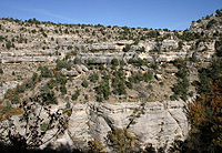 |
NPS National Park Service The National Park Service is the U.S. federal agency that manages all national parks, many national monuments, and other conservation and historical properties with various title designations... |
Arizona Arizona Arizona ; is a state located in the southwestern region of the United States. It is also part of the western United States and the mountain west. The capital and largest city is Phoenix... 35.17°N 111.51°W |
Walnut Canyon protects 25 cliff dwelling rooms constructed by the Sinagua Sinagua The Sinagua were a pre-Columbian cultural group occupying an area in central Arizona between the Little Colorado River and the Salt River including the Verde Valley and significant portions of the Mogollon Rim country between approximately 500 AD and 1425 AD.Early Sinagua sites consist of pit houses... people. It lies on the Colorado Plateau Colorado Plateau The Colorado Plateau, also called the Colorado Plateau Province, is a physiographic region of the Intermontane Plateaus, roughly centered on the Four Corners region of the southwestern United States. The province covers an area of 337,000 km2 within western Colorado, northwestern New Mexico,... and cuts through the Permian Permian The PermianThe term "Permian" was introduced into geology in 1841 by Sir Sir R. I. Murchison, president of the Geological Society of London, who identified typical strata in extensive Russian explorations undertaken with Edouard de Verneuil; Murchison asserted in 1841 that he named his "Permian... Kaibab Limestone Kaibab Limestone The Kaibab is a geologic formation that is spread across the U.S. states of northern Arizona, southern Utah, east central Nevada and southeast California. This geologic unit is part of the Park City Group in Nevada and Utah and is sometimes locally classified as a geologic group in Utah... , which exposes the Toroweap Formation and Coconino Sandstone Coconino Sandstone Coconino Sandstone is a geologic formation named after its exposure in Coconino County, Arizona. This formation spreads across the Colorado Plateau province of the United States, including northern Arizona, northwest Colorado, Nevada, and Utah.... . |
|
| White Sands White Sands National Monument The White Sands National Monument is a U.S. National Monument located about southwest of Alamogordo in western Otero County and northeastern Dona Ana County in the state of New Mexico, at an elevation of 4235 feet... |
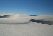 |
NPS National Park Service The National Park Service is the U.S. federal agency that manages all national parks, many national monuments, and other conservation and historical properties with various title designations... |
New Mexico New Mexico New Mexico is a state located in the southwest and western regions of the United States. New Mexico is also usually considered one of the Mountain States. With a population density of 16 per square mile, New Mexico is the sixth-most sparsely inhabited U.S... 32.78°N 106.17°W |
Located in the mountain-ringed Tularosa Basin Tularosa Basin The Tularosa Basin is a graben basin in the Basin and Range Province and within the Chihuahuan Desert, east of the Rio Grande in southern New Mexico, in the Southwestern United States.-Geography:... valley area, White Sands consists of the southern part of a 275 mi2 field of white sand dunes composed of gypsum Gypsum Gypsum is a very soft sulfate mineral composed of calcium sulfate dihydrate, with the chemical formula CaSO4·2H2O. It is found in alabaster, a decorative stone used in Ancient Egypt. It is the second softest mineral on the Mohs Hardness Scale... crystals. It is completely within the White Sands Missile Range White Sands Missile Range White Sands Missile Range is a rocket range of almost in parts of five counties in southern New Mexico. The largest military installation in the United States, WSMR includes the and the WSMR Otera Mesa bombing range... and is subject to closure when tests are conducted. |
|
| World War II Valor in the Pacific World War II Valor in the Pacific National Monument The World War II Valor in the Pacific National Monument is a United States national monument honoring several aspects of American engagement in World War II. It encompasses 9 sites in 3 states totaling :* - U.S. Fish and Wildlife Service... |
 |
NPS National Park Service The National Park Service is the U.S. federal agency that manages all national parks, many national monuments, and other conservation and historical properties with various title designations... , FWS United States Fish and Wildlife Service The United States Fish and Wildlife Service is a federal government agency within the United States Department of the Interior dedicated to the management of fish, wildlife, and natural habitats... |
Hawaii Hawaii Hawaii is the newest of the 50 U.S. states , and is the only U.S. state made up entirely of islands. It is the northernmost island group in Polynesia, occupying most of an archipelago in the central Pacific Ocean, southwest of the continental United States, southeast of Japan, and northeast of... , Alaska Alaska Alaska is the largest state in the United States by area. It is situated in the northwest extremity of the North American continent, with Canada to the east, the Arctic Ocean to the north, and the Pacific Ocean to the west and south, with Russia further west across the Bering Strait... , California California California is a state located on the West Coast of the United States. It is by far the most populous U.S. state, and the third-largest by land area... |
Valor in the Pacific encompasses nine sites in three states associated with World War II: The Attack on Pearl Harbor Attack on Pearl Harbor The attack on Pearl Harbor was a surprise military strike conducted by the Imperial Japanese Navy against the United States naval base at Pearl Harbor, Hawaii, on the morning of December 7, 1941... , including the USS Arizona USS Arizona Memorial The USS Arizona Memorial, located at Pearl Harbor in Honolulu, Hawaii, marks the resting place of 1,102 of the 1,177 sailors killed on the USS Arizona during the Attack on Pearl Harbor on December 7, 1941 by Japanese imperial forces and commemorates the events of that day... , Utah USS Utah (BB-31) USS Utah was a battleship that was attacked and sunk in Pearl Harbor on 7 December 1941. A Florida-class battleship, she was the only ship of the United States Navy to be named for the U.S. state of Utah... , and Oklahoma USS Oklahoma (BB-37) USS Oklahoma , the only ship of the United States Navy to ever be named for the 46th state, was a World War I-era battleship and the second of two ships in her class; her sister ship was . She, along with her sister, were the first two U.S... memorials in Hawaii; the Aleutian Islands Campaign on Attu Island Attu Island Attu is the westernmost and largest island in the Near Islands group of the Aleutian Islands of Alaska, making it the westernmost point of land relative to Alaska and the United States. It was the site of the only World War II land battle fought on the incorporated territory of the United States ,... , Kiska Kiska Kiska is an island in the Rat Islands group of the Aleutian Islands of Alaska located at . It is about long and varies in width from - Discovery :... Island, and Atka Island Atka Island Atka Island is the largest island in the Andreanof Islands of the Aleutian Islands of Alaska. The island is east of Adak Island. It is long and wide with a land area of , making it the 22nd largest island in the United States. The northeast of Atka Island contains the Korovin volcano which... in Alaska; and the Japanese American internment Japanese American internment Japanese-American internment was the relocation and internment by the United States government in 1942 of approximately 110,000 Japanese Americans and Japanese who lived along the Pacific coast of the United States to camps called "War Relocation Camps," in the wake of Imperial Japan's attack on... at Tule Lake War Relocation Center Tule Lake War Relocation Center Tule Lake Segregation Center National Monument was an internment camp in the northern California town of Newell near Tule Lake. It was used in the Japanese American internment during World War II. It was the largest and most controversial of the camps, and did not close until after the war, in... in California. |
|
| Wupatki Wupatki National Monument The Wupatki National Monument is a National Monument located in north-central Arizona, near Flagstaff. Rich in Native American ruins, the monument is administered by the National Park Service in close conjunction with the nearby Sunset Crater Volcano National Monument.Wupatki was listed on the... |
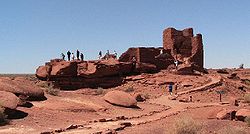 |
NPS National Park Service The National Park Service is the U.S. federal agency that manages all national parks, many national monuments, and other conservation and historical properties with various title designations... |
Arizona Arizona Arizona ; is a state located in the southwestern region of the United States. It is also part of the western United States and the mountain west. The capital and largest city is Phoenix... 35.56°N 111.38°W |
Many settlement sites built by the Sinagua Sinagua The Sinagua were a pre-Columbian cultural group occupying an area in central Arizona between the Little Colorado River and the Salt River including the Verde Valley and significant portions of the Mogollon Rim country between approximately 500 AD and 1425 AD.Early Sinagua sites consist of pit houses... , Cohonina, and Kayenta Anasazi are scattered throughout the monument. About 2000 Ancient Pueblo People moved here to farm after an 11th century eruption of Sunset Crater Sunset Crater Sunset Crater is a volcanic cinder cone located north of Flagstaff in U.S. State of Arizona. The crater is within the Sunset Crater Volcano National Monument.... . |
|
| Yucca House Yucca House National Monument Yucca House National Monument is a United States National Monument located in Montezuma County, Colorado between the towns of Towaoc and Cortez, Colorado... |
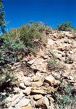 |
NPS National Park Service The National Park Service is the U.S. federal agency that manages all national parks, many national monuments, and other conservation and historical properties with various title designations... |
Colorado Colorado Colorado is a U.S. state that encompasses much of the Rocky Mountains as well as the northeastern portion of the Colorado Plateau and the western edge of the Great Plains... 37.25°N 108.69°W |
Designated a research national monument, it is a large, unexcavated Ancestral Puebloan archeological site. The site is one of many Anasazi (Ancestral Pueblo) village sites located in the Montezuma Valley occupied between AD 900 and 1300. |
See also
- List of areas in the United States National Park System
- List of National Historic Landmarks of the United States
- National MemorialNational MemorialNational Memorial is a designation in the United States for a protected area that memorializes a historic person or event. National memorials are authorized by the United States Congress...
- List of tourist attractions worldwide