

Bryce Canyon National Park
Encyclopedia
Bryce Canyon National Park (icon) is a national park
located in southwestern Utah
in the United States. The major feature of the park is Bryce Canyon which, despite its name, is not a canyon
but a giant natural amphitheater
created by erosion
along the eastern side of the Paunsaugunt Plateau
. Bryce is distinctive due to geological
structures called hoodoos
, formed by wind, water, and ice erosion of the river and lake bed sedimentary rock
s. The red, orange, and white colors of the rocks
provide spectacular views for park visitors. Bryce sits at a much higher elevation than nearby Zion National Park
. The rim at Bryce varies from 8,000 to 9,000 feet (2,400 to 2,700 m).
The Bryce area was settled by Mormon pioneers in the 1850s and was named after Ebenezer Bryce
, who homesteaded
in the area in 1874. The area around Bryce Canyon became a U.S. National Monument
in 1923 and was designated as a national park
in 1928. The park covers 56 square miles (145 km²) and receives relatively few visitors compared to Zion National Park and the Grand Canyon, largely due to its remote location. The town of Kanab, Utah
, is situated at a central point between these three parks.
about 50 miles (80.5 km) northeast of—and 1000 feet (304.8 m) higher than—Zion National Park
. The weather
in Bryce Canyon is therefore cooler, and the park receives more precipitation
: a total of 15 to 18 inches (38 to 46 cm) per year. Yearly temperatures vary from an average minimum of 9 °F (-12.8 °C) in January to an average maximum of 83 °F (28.3 °C) in July, but extreme temperatures can range from −30 °F to 97 °F (−34 °C to 36 °C). The record high temperature in the park was 98 °F (36.7 °C) on July 14, 2002. The record low temperature was -28 F on December 10, 1972.
The national park lies within the Colorado Plateau
geographic province
of North America and straddles the southeastern edge of the Paunsagunt Plateau west of the Paunsagunt Fault (Paunsagunt is Paiute
for "home of the beaver
"). Park visitors arrive from the plateau part of the park and look over the plateau's edge toward a valley containing the fault and the Paria River
just beyond it (Paria is Paiute for "muddy or elk water"). The edge of the Kaiparowits Plateau
bounds the opposite side of the valley.
Bryce Canyon was not formed from erosion
initiated from a central stream, meaning it technically is not a canyon
. Instead headward erosion
has excavated large amphitheater
-shaped features in the Cenozoic
-aged rocks of the Paunsagunt Plateau. This erosion exposed delicate and colorful pinnacles called hoodoos
that are up to 200 feet (61 m) high. A series of amphitheaters extends more than 20 miles (32.2 km) north-to-south within the park. The largest is Bryce Amphitheater, which is 12 miles (19.3 km) long, 3 miles (4.8 km) wide and 800 feet (243.8 m) deep. A nearby example of amphitheaters with hoodoos in the same formation but at a higher elevation, is in Cedar Breaks National Monument
, which is 25 miles (40.2 km) to the west on the Markagunt Plateau
.
Rainbow Point, the highest part of the park at 9105 feet (2,775.2 m), is at the end of the 18 miles (29 km) scenic drive. From there, Aquarius Plateau
, Bryce Amphitheater, the Henry Mountains
, the Vermilion Cliffs
and the White Cliffs can be seen. Yellow Creek, where it exits the park in the north-east section, is the lowest part of the park at 6620 feet (2,017.8 m).
show that people have been in the area for at least 10,000 years. Basketmaker
Anasazi artifacts several thousand years old have been found south of the park. Other artifacts from the Pueblo
-period Anasazi and the Fremont culture (up to the mid-12th century) have also been found.
The Paiute
Indians moved into the surrounding valleys and plateaus in the area around the same time that the other cultures left. These Native Americans
hunted and gathered for most of their food, but also supplemented their diet with some cultivated products. The Paiute in the area developed a mythology
surrounding the hoodoos (pinnacles) in Bryce Canyon. They believed that hoodoos were the Legend People whom the trickster Coyote
turned to stone. At least one older Paiute said his culture called the hoodoos Anka-ku-was-a-wits, which is Paiute for "red painted faces".
, and settlement.
 The first major scientific expedition to the area was led by U.S. Army
Major John Wesley Powell
in 1872. Powell, along with a team of mapmakers and geologists, surveyed the Sevier
and Virgin River
area as part of a larger survey of the Colorado Plateau
s. His mapmakers kept many of the Paiute place names.
Small groups of Mormon pioneers followed and attempted to settle east of Bryce Canyon along the Paria River
. In 1873, the Kanarra Cattle Company started to use the area for cattle grazing.
The Church of Jesus Christ of Latter-day Saints sent Scottish immigrant Ebenezer Bryce and his wife Mary to settle land in the Paria Valley because they thought his carpentry skills would be useful in the area. The Bryce family chose to live right below Bryce Canyon Amphitheater. Bryce grazed his cattle inside what are now park borders, and reputedly thought that the amphitheaters were a "helluva place to lose a cow." He also built a road to the plateau to retrieve firewood and timber, and a canal
to irrigate his crops and water his animals. Other settlers soon started to call the unusual place "Bryce's canyon", which was later formalized into Bryce Canyon.
A combination of drought
, overgrazing
and flood
ing eventually drove the remaining Paiutes from the area and prompted the settlers to attempt construction of a water diversion channel from the Sevier River drainage. When that effort failed, most of the settlers, including the Bryce family, left the area. Bryce moved his family to Arizona
in 1880. The remaining settlers dug a 10 miles (16.1 km) ditch from the Sevier's east fork into Tropic Valley.
 These scenic areas were first described for the public in magazine articles published by Union Pacific and Santa Fe railroads in 1916. People like Forest Supervisor J. W. Humphrey promoted the scenic wonders of Bryce Canyon's amphitheaters, and by 1918 nationally distributed articles also helped to spark interest. However, poor access to the remote area and the lack of accommodations kept visitation to a bare minimum.
Ruby Syrett, Harold Bowman and the Perry brothers later built modest lodging, and set up "touring services" in the area. Syrett later served as the first postmaster
of Bryce Canyon. Visitation steadily increased, and by the early 1920s the Union Pacific Railroad
became interested in expanding rail service
into southwestern Utah to accommodate more tourists.
 At the same time, conservationists
became alarmed by the damage overgrazing and logging
on the plateau, along with unregulated visitation, were having on the fragile features of Bryce Canyon. A movement to have the area protected was soon started, and National Park Service
Director Stephen Mather responded by proposing that Bryce Canyon be made into a state park. The governor of Utah and the Utah Legislature, however, lobbied for national protection of the area. Mather relented and sent his recommendation to President Warren G. Harding
, who on June 8, 1923 declared Bryce Canyon National Monument into existence.
A road was built the same year on the plateau to provide easy access to outlooks over the amphitheaters. From 1924 to 1925, Bryce Canyon Lodge
was built from local timber and stone.
Members of U.S. Congress started work in 1924 on upgrading Bryce Canyon's protection status from a U.S. National Monument
to a National Park in order to establish Utah National Park. A process led by the Utah Parks Company
for transferring ownership of private and state-held land in the monument to the federal government started in 1923. The last of the land in the proposed park's borders was sold to the federal government four years later, and on February 25, 1928, the renamed Bryce Canyon National Park was established.
In 1931, President Herbert Hoover
annexed an adjoining area south of the park, and in 1942 an additional 635 acres (2.6 km²) was added. This brought the park's total area to the current figure of 35835 acres (145 km²). Rim Road, the scenic drive that is still used today, was completed in 1934 by the Civilian Conservation Corps
. Administration of the park was conducted from neighboring Zion Canyon National Park until 1956, when Bryce Canyon's first superintendent started work.
was named for the park and served as a supply and repair ship in the U.S. Pacific Fleet
from September 15, 1950, to June 30, 1981.
Bryce Canyon Natural History Association
(BCNHA) was established in 1961. It runs the bookstore inside the park visitor center and is a non-profit organization created to aid the interpretive, educational and scientific activities of the National Park Service at Bryce Canyon National Park. A portion of the profits from all bookstore sales are donated to public land units.
Responding to increased visitation and traffic congestion
, the National Park Service implemented a voluntary, summer-only, in-park shuttle system in June 2000. In 2004, reconstruction began on the aging and inadequate road system in the park.
 The Bryce Canyon area shows a record of deposition that spans from the last part of the Cretaceous
period and the first half of the Cenozoic
era. The ancient depositional environment
of the region around what is now the park varied. The Dakota Sandstone
and the Tropic Shale were deposited in the warm, shallow waters of the advancing and retreating Cretaceous Seaway (outcrops of these rocks are found just outside park borders). The colorful Claron Formation, from which the park's delicate hoodoos
are carved, was laid down as sediments in a system of cool streams and lakes that existed from 63 to about 40 million years ago (from the Paleocene
to the Eocene
epochs). Different sediment types were laid down as the lakes deepened and became shallow and as the shoreline and river delta
s migrated.
Several other formations were also created but were mostly eroded
away following two major periods of uplift. The Laramide orogeny
affected the entire western part of what would become North America starting about 70 million to 50 million years ago. This event helped to build the ancestral Rocky Mountains
and in the process closed the Cretaceous Seaway. The Straight Cliffs, Wahweap, and Kaiparowits formations were victims of this uplift. The Colorado Plateau
s were uplifted 16 million years ago and were segmented into different plateau
s—each separated from its neighbors by faults and each having its own uplift rate. The Boat Mesa Conglomerate and the Sevier River Formation were removed by erosion following this uplift.
Vertical joints were created by this uplift, which were eventually (and still are) preferentially eroded. The easily eroded Pink Cliffs of the Claron Formation responded by forming freestanding pinnacles in badlands
called hoodoos, while the more resistant White Cliffs formed monoliths. The brown, pink and red colors are from hematite
(iron oxide; ); the yellows from limonite
; and the purples are from pyrolusite
. Also created were arches, natural bridges
, walls, and windows. Hoodoos are composed of soft sedimentary rock and are topped by a piece of harder, less easily eroded stone that protects the column from the elements. Bryce Canyon has one of the highest concentrations of hoodoos of any place on Earth.
The formations exposed in the area of the park are part of the Grand Staircase
. The oldest members of this supersequence of rock units are exposed in the Grand Canyon
, the intermediate ones in Zion National Park
, and its youngest parts are laid bare in Bryce Canyon area. A small amount of overlap occurs in and around each park.
 More than 400 native plant species live in the park. There are three life zones in the park based on elevation: The lowest areas of the park are dominated by dwarf forests of pinyon pine
and juniper
with manzanita
, serviceberry
, and antelope bitterbrush in between. Aspen
, cottonwood, Water Birch, and Willow
grow along streams. Ponderosa Pine
forests cover the mid-elevations with Blue Spruce and Douglas-fir
in water-rich areas and manzanita and bitterbrush as underbrush. Douglas-fir and White Fir
, along with Aspen and Engelmann Spruce
, make up the forests on the Paunsaugunt Plateau. The harshest areas have Limber Pine
and ancient Great Basin Bristlecone Pine
—some more than 1,600 years old—holding on.
 The forests and meadows of Bryce Canyon provide the habitat
to support diverse animal life, from bird
s and small mammal
s to fox
es and occasional bobcat
s, mountain lions, and black bear
s. Mule deer
are the most common large mammals in the park. Elk
and pronghorn antelope, which have been reintroduced nearby, sometimes venture into the park.
Bryce Canyon National Park forms part of the habitat of three wildlife species that are listed under the Endangered Species Act
: the Utah Prairie Dog
, the California Condor
, and the Southwestern Willow Flycatcher
. The Utah Prairie Dog is a threatened species that was reintroduced to the park for conservation, and the largest protected population is found within the park's boundaries.
About 170 species of birds visit the park each year, including swift
s and swallows. Most species migrate to warmer regions in winter, although jay
s, raven
s, nuthatch
es, eagle
s, and owl
s stay. In winter, the mule deer, mountain lion, and coyote
s migrate to lower elevations. Ground squirrel
s and marmot
s pass the winter in hibernation
.
Eleven species of reptile
s and four species of amphibian
s have been found at in the park. Reptiles include the Great Basin Rattlesnake
, Short-horned Lizard
, Side-blotched Lizard
, Striped Whipsnake
, and the Tiger Salamander
.
Also in the park are the black, lumpy, very slow-growing colonies of cryptobiotic soil
, which are a mix of lichen
s, algae
, fungi
, and cyanobacteria. Together these organism
s slow erosion, add nitrogen
to soil, and help it to retain moisture.
While humans have greatly reduced the amount of habitat that is available to wildlife in most parts of the United States, the relative scarcity of water in southern Utah restricts human development and helps account for the region's greatly enhanced diversity of wildlife.
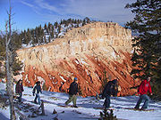 Most park visitors sightsee using the scenic drive, which provides access to 13 viewpoints over the amphitheaters. Bryce Canyon has eight marked and maintained hiking
trails that can be hiked in less than a day (round trip time, trailhead): Mossy Cave (one hour, State Route 12 northwest of Tropic), Rim Trail
(5–6 hours, anywhere on rim), Bristlecone Loop (one hour, Rainbow Point), and Queens Garden (1–2 hours, Sunrise Point) are easy to moderate hikes. Navajo Loop (1–2 hours, Sunset Point) and Tower Bridge (2–3 hours, north of Sunrise Point) are moderate hikes. Fairyland Loop (4–5 hours, Fairyland Point) and Peekaboo Loop (3–4 hours, Bryce Point) are strenuous hikes. Several of these trails intersect, allowing hikers to combine routes for more challenging hikes.
The park also has two trails designated for overnight hiking: the 9 miles (14.5 km) Riggs Spring Loop Trail
and the 23 miles (37 km) Under-the-Rim Trail
. Both require a backcountry camping permit. In total there are 50 miles (80.5 km) of trails in the park.
 More than 10 miles (16.1 km) of marked but ungroomed skiing
trails are available off of Fairyland, Paria, and Rim trails in the park. Twenty miles (32 km) of connecting groomed ski trails are in nearby Dixie National Forest
and Ruby's Inn.
The air in the area is so clear that on most days from Yovimpa and Rainbow points, Navajo Mountain
and the Kaibab Plateau can be seen 90 miles (144.8 km) away in Arizona
. On extremely clear days, the Black Mesas of eastern Arizona and western New Mexico
can be seen some 160 miles (257.5 km) away.
The park also has a 7.4 magnitude night sky, making it one of the darkest in North America. Stargazers can therefore see 7,500 stars with the naked eye
, while in most places fewer than 2,000 can be seen due to light pollution
(in many large cities only a few dozen can be seen). Park rangers host public stargazing events and evening programs on astronomy, nocturnal animals, and night sky protection. The Bryce Canyon Astronomy Festival, typically held in June, attracts thousands of visitors. In honor of this astronomy festival, Asteroid 49272
was named after the national park.
There are two campgrounds in the park, North Campground and Sunset Campground. Loop A in North Campground is open year-round. Additional loops and Sunset Campground are open from late spring to early autumn. The 114-room Bryce Canyon Lodge
is another way to overnight in the park.
A favorite activity of most visitors is landscape photography. With Bryce Canyon's high altitude and clean air, the sunrise and sunset photographs can be spectacular.
National park
A national park is a reserve of natural, semi-natural, or developed land that a sovereign state declares or owns. Although individual nations designate their own national parks differently A national park is a reserve of natural, semi-natural, or developed land that a sovereign state declares or...
located in southwestern Utah
Utah
Utah is a state in the Western United States. It was the 45th state to join the Union, on January 4, 1896. Approximately 80% of Utah's 2,763,885 people live along the Wasatch Front, centering on Salt Lake City. This leaves vast expanses of the state nearly uninhabited, making the population the...
in the United States. The major feature of the park is Bryce Canyon which, despite its name, is not a canyon
Canyon
A canyon or gorge is a deep ravine between cliffs often carved from the landscape by a river. Rivers have a natural tendency to reach a baseline elevation, which is the same elevation as the body of water it will eventually drain into. This forms a canyon. Most canyons were formed by a process of...
but a giant natural amphitheater
Amphitheatre
An amphitheatre is an open-air venue used for entertainment and performances.There are two similar, but distinct, types of structure for which the word "amphitheatre" is used: Ancient Roman amphitheatres were large central performance spaces surrounded by ascending seating, and were commonly used...
created by erosion
Erosion
Erosion is when materials are removed from the surface and changed into something else. It only works by hydraulic actions and transport of solids in the natural environment, and leads to the deposition of these materials elsewhere...
along the eastern side of the Paunsaugunt Plateau
Paunsaugunt Plateau
The Paunsaugunt Plateau is a dissected plateau, rising to an elevation of , in southwestern Utah in the United States. Located in northern Kane County and southwestern Garfield County, it is approximately wide, and extends southward from the Sevier Plateau approximately , terminating in the Pink...
. Bryce is distinctive due to geological
Geology
Geology is the science comprising the study of solid Earth, the rocks of which it is composed, and the processes by which it evolves. Geology gives insight into the history of the Earth, as it provides the primary evidence for plate tectonics, the evolutionary history of life, and past climates...
structures called hoodoos
Hoodoo (geology)
A hoodoo is a tall, thin spire of rock that protrudes from the bottom of an arid drainage basin or badland. Hoodoos consist of relatively soft rock topped by harder, less easily eroded stone that protects each column from the elements...
, formed by wind, water, and ice erosion of the river and lake bed sedimentary rock
Sedimentary rock
Sedimentary rock are types of rock that are formed by the deposition of material at the Earth's surface and within bodies of water. Sedimentation is the collective name for processes that cause mineral and/or organic particles to settle and accumulate or minerals to precipitate from a solution....
s. The red, orange, and white colors of the rocks
Rock (geology)
In geology, rock or stone is a naturally occurring solid aggregate of minerals and/or mineraloids.The Earth's outer solid layer, the lithosphere, is made of rock. In general rocks are of three types, namely, igneous, sedimentary, and metamorphic...
provide spectacular views for park visitors. Bryce sits at a much higher elevation than nearby Zion National Park
Zion National Park
Zion National Park is located in the Southwestern United States, near Springdale, Utah. A prominent feature of the park is Zion Canyon, which is 15 miles long and up to half a mile deep, cut through the reddish and tan-colored Navajo Sandstone by the North Fork of the Virgin River...
. The rim at Bryce varies from 8,000 to 9,000 feet (2,400 to 2,700 m).
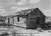
The Bryce area was settled by Mormon pioneers in the 1850s and was named after Ebenezer Bryce
Ebenezer Bryce
Ebenezer Bryce was a Mormon pioneer, best known as the person for whom Bryce Canyon National Park was named....
, who homesteaded
Homesteading
Broadly defined, homesteading is a lifestyle of simple self-sufficiency.-Current practice:The term may apply to anyone who follows the back-to-the-land movement by adopting a sustainable, self-sufficient lifestyle. While land is no longer freely available in most areas of the world, homesteading...
in the area in 1874. The area around Bryce Canyon became a U.S. National Monument
U.S. National Monument
A National Monument in the United States is a protected area that is similar to a National Park except that the President of the United States can quickly declare an area of the United States to be a National Monument without the approval of Congress. National monuments receive less funding and...
in 1923 and was designated as a national park
National Park Service
The National Park Service is the U.S. federal agency that manages all national parks, many national monuments, and other conservation and historical properties with various title designations...
in 1928. The park covers 56 square miles (145 km²) and receives relatively few visitors compared to Zion National Park and the Grand Canyon, largely due to its remote location. The town of Kanab, Utah
Kanab, Utah
Kanab is a city in and the county seat of Kane County, Utah, United States. The area was first settled in 1864 and the town was founded in 1870 when ten Mormon families moved into the area. The population was 3,564 at the 2000 census...
, is situated at a central point between these three parks.
Geography and climate
Bryce Canyon National Park is located in southwestern UtahUtah
Utah is a state in the Western United States. It was the 45th state to join the Union, on January 4, 1896. Approximately 80% of Utah's 2,763,885 people live along the Wasatch Front, centering on Salt Lake City. This leaves vast expanses of the state nearly uninhabited, making the population the...
about 50 miles (80.5 km) northeast of—and 1000 feet (304.8 m) higher than—Zion National Park
Zion National Park
Zion National Park is located in the Southwestern United States, near Springdale, Utah. A prominent feature of the park is Zion Canyon, which is 15 miles long and up to half a mile deep, cut through the reddish and tan-colored Navajo Sandstone by the North Fork of the Virgin River...
. The weather
Weather
Weather is the state of the atmosphere, to the degree that it is hot or cold, wet or dry, calm or stormy, clear or cloudy. Most weather phenomena occur in the troposphere, just below the stratosphere. Weather refers, generally, to day-to-day temperature and precipitation activity, whereas climate...
in Bryce Canyon is therefore cooler, and the park receives more precipitation
Precipitation (meteorology)
In meteorology, precipitation In meteorology, precipitation In meteorology, precipitation (also known as one of the classes of hydrometeors, which are atmospheric water phenomena is any product of the condensation of atmospheric water vapor that falls under gravity. The main forms of precipitation...
: a total of 15 to 18 inches (38 to 46 cm) per year. Yearly temperatures vary from an average minimum of 9 °F (-12.8 °C) in January to an average maximum of 83 °F (28.3 °C) in July, but extreme temperatures can range from −30 °F to 97 °F (−34 °C to 36 °C). The record high temperature in the park was 98 °F (36.7 °C) on July 14, 2002. The record low temperature was -28 F on December 10, 1972.
The national park lies within the Colorado Plateau
Colorado Plateau
The Colorado Plateau, also called the Colorado Plateau Province, is a physiographic region of the Intermontane Plateaus, roughly centered on the Four Corners region of the southwestern United States. The province covers an area of 337,000 km2 within western Colorado, northwestern New Mexico,...
geographic province
United States physiographic region
The list of continental United States Physiographic regions identifies the 8 regions, 25 provinces, and 85 sections. The system dates to Nevin Fenneman's paper Physiographic Subdivision of the United States, published in 1917...
of North America and straddles the southeastern edge of the Paunsagunt Plateau west of the Paunsagunt Fault (Paunsagunt is Paiute
Paiute
Paiute refers to three closely related groups of Native Americans — the Northern Paiute of California, Idaho, Nevada and Oregon; the Owens Valley Paiute of California and Nevada; and the Southern Paiute of Arizona, southeastern California and Nevada, and Utah.-Origin of name:The origin of...
for "home of the beaver
Beaver
The beaver is a primarily nocturnal, large, semi-aquatic rodent. Castor includes two extant species, North American Beaver and Eurasian Beaver . Beavers are known for building dams, canals, and lodges . They are the second-largest rodent in the world...
"). Park visitors arrive from the plateau part of the park and look over the plateau's edge toward a valley containing the fault and the Paria River
Paria River
The Paria River is a tributary of the Colorado River, approximately long, in southern Utah and northern Arizona in the United States. It drains a rugged and arid region northwest of the Colorado, flowing through roadless slot canyons along part of its course....
just beyond it (Paria is Paiute for "muddy or elk water"). The edge of the Kaiparowits Plateau
Kaiparowits Plateau
right|Location of the Kaiparowits Plateau within UtahThe Kaiparowits Plateau is a large, elevated landform located in southern Utah, in the southwestern United States. Along with the Grand Staircase and the Canyons of the Escalante, it makes up a significant portion of the Grand...
bounds the opposite side of the valley.
Bryce Canyon was not formed from erosion
Erosion
Erosion is when materials are removed from the surface and changed into something else. It only works by hydraulic actions and transport of solids in the natural environment, and leads to the deposition of these materials elsewhere...
initiated from a central stream, meaning it technically is not a canyon
Canyon
A canyon or gorge is a deep ravine between cliffs often carved from the landscape by a river. Rivers have a natural tendency to reach a baseline elevation, which is the same elevation as the body of water it will eventually drain into. This forms a canyon. Most canyons were formed by a process of...
. Instead headward erosion
Headward erosion
Headward erosion is a fluvial process of erosion that lengthens a stream, a valley or a gully at its head and also enlarges its drainage basin. The stream erodes away at the rock and soil at its headwaters in the opposite direction that it flows. Once a stream has begun to cut back, the erosion is...
has excavated large amphitheater
Amphitheatre
An amphitheatre is an open-air venue used for entertainment and performances.There are two similar, but distinct, types of structure for which the word "amphitheatre" is used: Ancient Roman amphitheatres were large central performance spaces surrounded by ascending seating, and were commonly used...
-shaped features in the Cenozoic
Cenozoic
The Cenozoic era is the current and most recent of the three Phanerozoic geological eras and covers the period from 65.5 mya to the present. The era began in the wake of the Cretaceous–Tertiary extinction event at the end of the Cretaceous that saw the demise of the last non-avian dinosaurs and...
-aged rocks of the Paunsagunt Plateau. This erosion exposed delicate and colorful pinnacles called hoodoos
Hoodoo (geology)
A hoodoo is a tall, thin spire of rock that protrudes from the bottom of an arid drainage basin or badland. Hoodoos consist of relatively soft rock topped by harder, less easily eroded stone that protects each column from the elements...
that are up to 200 feet (61 m) high. A series of amphitheaters extends more than 20 miles (32.2 km) north-to-south within the park. The largest is Bryce Amphitheater, which is 12 miles (19.3 km) long, 3 miles (4.8 km) wide and 800 feet (243.8 m) deep. A nearby example of amphitheaters with hoodoos in the same formation but at a higher elevation, is in Cedar Breaks National Monument
Cedar Breaks National Monument
Cedar Breaks National Monument is a U.S. National Monument located in the U.S. state of Utah near Cedar City. Cedar Breaks is a natural amphitheater canyon, stretching across , with a depth of over . The elevation of the rim of the canyon is over above sea level.The eroded rock of the canyon is...
, which is 25 miles (40.2 km) to the west on the Markagunt Plateau
Markagunt Plateau
The Markagunt Plateau is an plateau located in southwestern Utah between Interstate 15 and U.S. Route 89. It is one of the plateaus that make up the High Plateaus Section of the Colorado Plateau. The plateau encompasses Cedar Breaks National Monument and is part of Cedar Mountain District of...
.
Rainbow Point, the highest part of the park at 9105 feet (2,775.2 m), is at the end of the 18 miles (29 km) scenic drive. From there, Aquarius Plateau
Aquarius Plateau
The Aquarius Plateau is a physiographic region within Garfield and Wayne counties in south-central Utah. The plateau, an uplift on the much larger Colorado Plateau, is the highest in North America...
, Bryce Amphitheater, the Henry Mountains
Henry Mountains
The Henry Mountains are located in the southeastern portion of the U.S. state of Utah and run in a generally north-south direction, extending over a distance of about 30 miles . They were named by John Wesley Powell in honour of Joseph Henry, the first secretary of the Smithsonian Institution. The...
, the Vermilion Cliffs
Vermilion Cliffs
The Vermilion Cliffs are the second "step" up in the five-step Grand Staircase of the Colorado Plateau. Reddish or vermilion-colored cliffs are found along U.S. Highway 89 and U.S. Highway 89A near Kanab, Utah . They extend from a location near Page, Arizona, west for a considerable distance, in...
and the White Cliffs can be seen. Yellow Creek, where it exits the park in the north-east section, is the lowest part of the park at 6620 feet (2,017.8 m).
Native American habitation
Little is known about early human habitation in the Bryce Canyon area. Archaeological surveys of Bryce Canyon National Park and the Paunsaugunt PlateauPaunsaugunt Plateau
The Paunsaugunt Plateau is a dissected plateau, rising to an elevation of , in southwestern Utah in the United States. Located in northern Kane County and southwestern Garfield County, it is approximately wide, and extends southward from the Sevier Plateau approximately , terminating in the Pink...
show that people have been in the area for at least 10,000 years. Basketmaker
Basketmaker (culture)
The Basketmaker culture of the Ancient Pueblo People began about 1500 BC and continued until about AD 500 with the beginning of the Pueblo I Era...
Anasazi artifacts several thousand years old have been found south of the park. Other artifacts from the Pueblo
Pueblo
Pueblo is a term used to describe modern communities of Native Americans in the Southwestern United States of America. The first Spanish explorers of the Southwest used this term to describe the communities housed in apartment-like structures built of stone, adobe mud, and other local material...
-period Anasazi and the Fremont culture (up to the mid-12th century) have also been found.
The Paiute
Paiute
Paiute refers to three closely related groups of Native Americans — the Northern Paiute of California, Idaho, Nevada and Oregon; the Owens Valley Paiute of California and Nevada; and the Southern Paiute of Arizona, southeastern California and Nevada, and Utah.-Origin of name:The origin of...
Indians moved into the surrounding valleys and plateaus in the area around the same time that the other cultures left. These Native Americans
Native Americans in the United States
Native Americans in the United States are the indigenous peoples in North America within the boundaries of the present-day continental United States, parts of Alaska, and the island state of Hawaii. They are composed of numerous, distinct tribes, states, and ethnic groups, many of which survive as...
hunted and gathered for most of their food, but also supplemented their diet with some cultivated products. The Paiute in the area developed a mythology
Native American mythology
Native American mythology is the body of traditional narratives associated with Native American religion from a mythographical perspective. Native American belief systems include many sacred narratives. Such spiritual stories are deeply based in Nature and are rich with the symbolism of seasons,...
surrounding the hoodoos (pinnacles) in Bryce Canyon. They believed that hoodoos were the Legend People whom the trickster Coyote
Coyote (mythology)
Coyote is a mythological character common to many Native American cultures, based on the coyote animal. This character is usually male and is generally anthropomorphic although he may have some coyote-like physical features such as fur, pointed ears, yellow eyes, a tail and claws...
turned to stone. At least one older Paiute said his culture called the hoodoos Anka-ku-was-a-wits, which is Paiute for "red painted faces".
European American exploration and settlement
It was not until the late 18th and the early 19th century that the first European Americans explored the remote and hard-to-reach area. Mormon scouts visited the area in the 1850s to gauge its potential for agricultural development, use for grazingGrazing
Grazing generally describes a type of feeding, in which a herbivore feeds on plants , and also on other multicellular autotrophs...
, and settlement.
United States Army
The United States Army is the main branch of the United States Armed Forces responsible for land-based military operations. It is the largest and oldest established branch of the U.S. military, and is one of seven U.S. uniformed services...
Major John Wesley Powell
John Wesley Powell
John Wesley Powell was a U.S. soldier, geologist, explorer of the American West, and director of major scientific and cultural institutions...
in 1872. Powell, along with a team of mapmakers and geologists, surveyed the Sevier
Sevier River
The Sevier River , extending , is the longest Utah river entirely in the state and drains an extended chain of mountain farming valleys to the intermittent Sevier Lake...
and Virgin River
Virgin River
The Virgin River is a tributary of the Colorado River in the U.S. states of Utah, Nevada, and Arizona. The river is about long. It was designated Utah's first wild and scenic river in 2009, during the centennial celebration of Zion National Park.-Course:...
area as part of a larger survey of the Colorado Plateau
Colorado Plateau
The Colorado Plateau, also called the Colorado Plateau Province, is a physiographic region of the Intermontane Plateaus, roughly centered on the Four Corners region of the southwestern United States. The province covers an area of 337,000 km2 within western Colorado, northwestern New Mexico,...
s. His mapmakers kept many of the Paiute place names.
Small groups of Mormon pioneers followed and attempted to settle east of Bryce Canyon along the Paria River
Paria River
The Paria River is a tributary of the Colorado River, approximately long, in southern Utah and northern Arizona in the United States. It drains a rugged and arid region northwest of the Colorado, flowing through roadless slot canyons along part of its course....
. In 1873, the Kanarra Cattle Company started to use the area for cattle grazing.
The Church of Jesus Christ of Latter-day Saints sent Scottish immigrant Ebenezer Bryce and his wife Mary to settle land in the Paria Valley because they thought his carpentry skills would be useful in the area. The Bryce family chose to live right below Bryce Canyon Amphitheater. Bryce grazed his cattle inside what are now park borders, and reputedly thought that the amphitheaters were a "helluva place to lose a cow." He also built a road to the plateau to retrieve firewood and timber, and a canal
Canal
Canals are man-made channels for water. There are two types of canal:#Waterways: navigable transportation canals used for carrying ships and boats shipping goods and conveying people, further subdivided into two kinds:...
to irrigate his crops and water his animals. Other settlers soon started to call the unusual place "Bryce's canyon", which was later formalized into Bryce Canyon.
A combination of drought
Drought
A drought is an extended period of months or years when a region notes a deficiency in its water supply. Generally, this occurs when a region receives consistently below average precipitation. It can have a substantial impact on the ecosystem and agriculture of the affected region...
, overgrazing
Overgrazing
Overgrazing occurs when plants are exposed to intensive grazing for extended periods of time, or without sufficient recovery periods. It can be caused by either livestock in poorly managed agricultural applications, or by overpopulations of native or non-native wild animals.Overgrazing reduces the...
and flood
Flood
A flood is an overflow of an expanse of water that submerges land. The EU Floods directive defines a flood as a temporary covering by water of land not normally covered by water...
ing eventually drove the remaining Paiutes from the area and prompted the settlers to attempt construction of a water diversion channel from the Sevier River drainage. When that effort failed, most of the settlers, including the Bryce family, left the area. Bryce moved his family to Arizona
Arizona
Arizona ; is a state located in the southwestern region of the United States. It is also part of the western United States and the mountain west. The capital and largest city is Phoenix...
in 1880. The remaining settlers dug a 10 miles (16.1 km) ditch from the Sevier's east fork into Tropic Valley.
Creation of the park
Ruby Syrett, Harold Bowman and the Perry brothers later built modest lodging, and set up "touring services" in the area. Syrett later served as the first postmaster
Postmaster
A postmaster is the head of an individual post office. Postmistress is not used anymore in the United States, as the "master" component of the word refers to a person of authority and has no gender quality...
of Bryce Canyon. Visitation steadily increased, and by the early 1920s the Union Pacific Railroad
Union Pacific Railroad
The Union Pacific Railroad , headquartered in Omaha, Nebraska, is the largest railroad network in the United States. James R. Young is president, CEO and Chairman....
became interested in expanding rail service
Rail transport in the United States
Presently, most rail transport in the United States is based on freight train shipments. The U.S. rail industry has experienced repeated convulsions due to changing U.S. economic needs and the rise of automobile, bus, and air transport....
into southwestern Utah to accommodate more tourists.
Conservation ethic
Conservation is an ethic of resource use, allocation, and protection. Its primary focus is upon maintaining the health of the natural world: its, fisheries, habitats, and biological diversity. Secondary focus is on materials conservation and energy conservation, which are seen as important to...
became alarmed by the damage overgrazing and logging
Logging
Logging is the cutting, skidding, on-site processing, and loading of trees or logs onto trucks.In forestry, the term logging is sometimes used in a narrow sense concerning the logistics of moving wood from the stump to somewhere outside the forest, usually a sawmill or a lumber yard...
on the plateau, along with unregulated visitation, were having on the fragile features of Bryce Canyon. A movement to have the area protected was soon started, and National Park Service
National Park Service
The National Park Service is the U.S. federal agency that manages all national parks, many national monuments, and other conservation and historical properties with various title designations...
Director Stephen Mather responded by proposing that Bryce Canyon be made into a state park. The governor of Utah and the Utah Legislature, however, lobbied for national protection of the area. Mather relented and sent his recommendation to President Warren G. Harding
Warren G. Harding
Warren Gamaliel Harding was the 29th President of the United States . A Republican from Ohio, Harding was an influential self-made newspaper publisher. He served in the Ohio Senate , as the 28th Lieutenant Governor of Ohio and as a U.S. Senator...
, who on June 8, 1923 declared Bryce Canyon National Monument into existence.
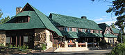
A road was built the same year on the plateau to provide easy access to outlooks over the amphitheaters. From 1924 to 1925, Bryce Canyon Lodge
Bryce Canyon Lodge
Bryce Canyon Lodge is a lodge in Bryce Canyon National Park, Utah. It was built between 1924 and 1925 using local materials. Designed by architect Gilbert Stanley Underwood, the lodge is an excellent example of National Park Service Rustic design...
was built from local timber and stone.
Members of U.S. Congress started work in 1924 on upgrading Bryce Canyon's protection status from a U.S. National Monument
U.S. National Monument
A National Monument in the United States is a protected area that is similar to a National Park except that the President of the United States can quickly declare an area of the United States to be a National Monument without the approval of Congress. National monuments receive less funding and...
to a National Park in order to establish Utah National Park. A process led by the Utah Parks Company
Utah Parks Company
The Utah Parks Company, a subsidiary of Union Pacific Railroad, owned and operated restaurants, lodging, and bus tours in Bryce Canyon and Zion National Parks, the north rim of Grand Canyon National Park, and Cedar Breaks National Monument from the 1920s until 1972. Operating as a concessionaire...
for transferring ownership of private and state-held land in the monument to the federal government started in 1923. The last of the land in the proposed park's borders was sold to the federal government four years later, and on February 25, 1928, the renamed Bryce Canyon National Park was established.
In 1931, President Herbert Hoover
Herbert Hoover
Herbert Clark Hoover was the 31st President of the United States . Hoover was originally a professional mining engineer and author. As the United States Secretary of Commerce in the 1920s under Presidents Warren Harding and Calvin Coolidge, he promoted partnerships between government and business...
annexed an adjoining area south of the park, and in 1942 an additional 635 acres (2.6 km²) was added. This brought the park's total area to the current figure of 35835 acres (145 km²). Rim Road, the scenic drive that is still used today, was completed in 1934 by the Civilian Conservation Corps
Civilian Conservation Corps
The Civilian Conservation Corps was a public work relief program that operated from 1933 to 1942 in the United States for unemployed, unmarried men from relief families, ages 18–25. A part of the New Deal of President Franklin D...
. Administration of the park was conducted from neighboring Zion Canyon National Park until 1956, when Bryce Canyon's first superintendent started work.
More recent history
The USS Bryce CanyonUSS Bryce Canyon (AD-36)
USS Bryce Canyon was a , the only ship to be named for the Bryce Canyon National Park in Utah.Bryce Canyon was launched 7 March 1946 by Charleston Navy Yard and sponsored by Mrs. William J. Carter, wife of Rear Admiral Carter. Little additional work was done on her until after the outbreak of the...
was named for the park and served as a supply and repair ship in the U.S. Pacific Fleet
United States Pacific Fleet
The United States Pacific Fleet is a Pacific Ocean theater-level component command of the United States Navy that provides naval resources under the operational control of the United States Pacific Command. Its home port is at Pearl Harbor Naval Base, Hawaii. It is commanded by Admiral Patrick M...
from September 15, 1950, to June 30, 1981.
Bryce Canyon Natural History Association
Bryce Canyon Natural History Association
Bryce Canyon Natural History Association is a non-profit organization created to aid the interpretive, educational and scientific activities of the National Park Service, at Bryce Canyon National Park and the USDA Forest Service on the Dixie National Forest. A portion of the profits from all...
(BCNHA) was established in 1961. It runs the bookstore inside the park visitor center and is a non-profit organization created to aid the interpretive, educational and scientific activities of the National Park Service at Bryce Canyon National Park. A portion of the profits from all bookstore sales are donated to public land units.
Responding to increased visitation and traffic congestion
Traffic congestion
Traffic congestion is a condition on road networks that occurs as use increases, and is characterized by slower speeds, longer trip times, and increased vehicular queueing. The most common example is the physical use of roads by vehicles. When traffic demand is great enough that the interaction...
, the National Park Service implemented a voluntary, summer-only, in-park shuttle system in June 2000. In 2004, reconstruction began on the aging and inadequate road system in the park.
Geology
Cretaceous
The Cretaceous , derived from the Latin "creta" , usually abbreviated K for its German translation Kreide , is a geologic period and system from circa to million years ago. In the geologic timescale, the Cretaceous follows the Jurassic period and is followed by the Paleogene period of the...
period and the first half of the Cenozoic
Cenozoic
The Cenozoic era is the current and most recent of the three Phanerozoic geological eras and covers the period from 65.5 mya to the present. The era began in the wake of the Cretaceous–Tertiary extinction event at the end of the Cretaceous that saw the demise of the last non-avian dinosaurs and...
era. The ancient depositional environment
Sedimentary depositional environment
In geology, sedimentary depositional environment describes the combination of physical, chemical and biological processes associated with the deposition of a particular type of sediment and, therefore, the rock types that will be formed after lithification, if the sediment is preserved in the rock...
of the region around what is now the park varied. The Dakota Sandstone
Dakota Sandstone
The Dakota Sandstone is a general term for an ill-defined early Cretaceous formation of the Rocky Mountains and Great Plains. It consists of sandy, shallow-marine deposits with intermittent mud flat sediments, and occasional stream deposits...
and the Tropic Shale were deposited in the warm, shallow waters of the advancing and retreating Cretaceous Seaway (outcrops of these rocks are found just outside park borders). The colorful Claron Formation, from which the park's delicate hoodoos
Hoodoo (geology)
A hoodoo is a tall, thin spire of rock that protrudes from the bottom of an arid drainage basin or badland. Hoodoos consist of relatively soft rock topped by harder, less easily eroded stone that protects each column from the elements...
are carved, was laid down as sediments in a system of cool streams and lakes that existed from 63 to about 40 million years ago (from the Paleocene
Paleocene
The Paleocene or Palaeocene, the "early recent", is a geologic epoch that lasted from about . It is the first epoch of the Palaeogene Period in the modern Cenozoic Era...
to the Eocene
Eocene
The Eocene Epoch, lasting from about 56 to 34 million years ago , is a major division of the geologic timescale and the second epoch of the Paleogene Period in the Cenozoic Era. The Eocene spans the time from the end of the Palaeocene Epoch to the beginning of the Oligocene Epoch. The start of the...
epochs). Different sediment types were laid down as the lakes deepened and became shallow and as the shoreline and river delta
River delta
A delta is a landform that is formed at the mouth of a river where that river flows into an ocean, sea, estuary, lake, reservoir, flat arid area, or another river. Deltas are formed from the deposition of the sediment carried by the river as the flow leaves the mouth of the river...
s migrated.
Several other formations were also created but were mostly eroded
Erosion
Erosion is when materials are removed from the surface and changed into something else. It only works by hydraulic actions and transport of solids in the natural environment, and leads to the deposition of these materials elsewhere...
away following two major periods of uplift. The Laramide orogeny
Laramide orogeny
The Laramide orogeny was a period of mountain building in western North America, which started in the Late Cretaceous, 70 to 80 million years ago, and ended 35 to 55 million years ago. The exact duration and ages of beginning and end of the orogeny are in dispute, as is the cause. The Laramide...
affected the entire western part of what would become North America starting about 70 million to 50 million years ago. This event helped to build the ancestral Rocky Mountains
Rocky Mountains
The Rocky Mountains are a major mountain range in western North America. The Rocky Mountains stretch more than from the northernmost part of British Columbia, in western Canada, to New Mexico, in the southwestern United States...
and in the process closed the Cretaceous Seaway. The Straight Cliffs, Wahweap, and Kaiparowits formations were victims of this uplift. The Colorado Plateau
Colorado Plateau
The Colorado Plateau, also called the Colorado Plateau Province, is a physiographic region of the Intermontane Plateaus, roughly centered on the Four Corners region of the southwestern United States. The province covers an area of 337,000 km2 within western Colorado, northwestern New Mexico,...
s were uplifted 16 million years ago and were segmented into different plateau
Plateau
In geology and earth science, a plateau , also called a high plain or tableland, is an area of highland, usually consisting of relatively flat terrain. A highly eroded plateau is called a dissected plateau...
s—each separated from its neighbors by faults and each having its own uplift rate. The Boat Mesa Conglomerate and the Sevier River Formation were removed by erosion following this uplift.
Vertical joints were created by this uplift, which were eventually (and still are) preferentially eroded. The easily eroded Pink Cliffs of the Claron Formation responded by forming freestanding pinnacles in badlands
Badlands
A badlands is a type of dry terrain where softer sedimentary rocks and clay-rich soils have been extensively eroded by wind and water. It can resemble malpaís, a terrain of volcanic rock. Canyons, ravines, gullies, hoodoos and other such geological forms are common in badlands. They are often...
called hoodoos, while the more resistant White Cliffs formed monoliths. The brown, pink and red colors are from hematite
Hematite
Hematite, also spelled as haematite, is the mineral form of iron oxide , one of several iron oxides. Hematite crystallizes in the rhombohedral system, and it has the same crystal structure as ilmenite and corundum...
(iron oxide; ); the yellows from limonite
Limonite
Limonite is an ore consisting in a mixture of hydrated iron oxide-hydroxide of varying composition. The generic formula is frequently written as FeO·nH2O, although this is not entirely accurate as limonite often contains a varying amount of oxide compared to hydroxide.Together with hematite, it has...
; and the purples are from pyrolusite
Pyrolusite
Pyrolusite is a mineral consisting essentially of manganese dioxide and is important as an ore of manganese. It is a black, amorphous appearing mineral, often with a granular, fibrous or columnar structure, sometimes forming reniform crusts. It has a metallic luster, a black or bluish-black...
. Also created were arches, natural bridges
Natural arch
A natural arch or natural bridge is a natural geological formation where a rock arch forms, with an opening underneath. Most natural arches form as a narrow ridge, walled by cliffs, become narrower from erosion, with a softer rock stratum under the cliff-forming stratum gradually eroding out until...
, walls, and windows. Hoodoos are composed of soft sedimentary rock and are topped by a piece of harder, less easily eroded stone that protects the column from the elements. Bryce Canyon has one of the highest concentrations of hoodoos of any place on Earth.
The formations exposed in the area of the park are part of the Grand Staircase
Grand Staircase
For the similarly named structure on the RMS Titanic, see Grand Staircase of the TitanicFor the stairs in the White House see Grand Staircase ...
. The oldest members of this supersequence of rock units are exposed in the Grand Canyon
Grand Canyon
The Grand Canyon is a steep-sided canyon carved by the Colorado River in the United States in the state of Arizona. It is largely contained within the Grand Canyon National Park, the 15th national park in the United States...
, the intermediate ones in Zion National Park
Zion National Park
Zion National Park is located in the Southwestern United States, near Springdale, Utah. A prominent feature of the park is Zion Canyon, which is 15 miles long and up to half a mile deep, cut through the reddish and tan-colored Navajo Sandstone by the North Fork of the Virgin River...
, and its youngest parts are laid bare in Bryce Canyon area. A small amount of overlap occurs in and around each park.
Biology
Pinyon pine
The pinyon pine group grows in the southwestern United States and in Mexico. The trees yield edible pinyon nuts, which were a staple of the Native Americans, and are still widely eaten...
and juniper
Juniper
Junipers are coniferous plants in the genus Juniperus of the cypress family Cupressaceae. Depending on taxonomic viewpoint, there are between 50-67 species of juniper, widely distributed throughout the northern hemisphere, from the Arctic, south to tropical Africa in the Old World, and to the...
with manzanita
Manzanita
Manzanita is a common name for many species of the genus Arctostaphylos. They are evergreen shrubs or small trees present in the chaparral biome of western North America, where they occur from southern British Columbia, Washington to California, Arizona and New Mexico in the United States, and...
, serviceberry
Serviceberry
Amelanchier , also known as shadbush, shadwood or shadblow, serviceberry or sarvisberry, wild pear, juneberry, saskatoon, sugarplum or wild-plum, and chuckley pear is a genus of about 20 species of deciduous-leaved shrubs and small trees in the Rose family .Amelanchier is native to temperate regions...
, and antelope bitterbrush in between. Aspen
Aspen
Populus section Populus, of the Populus genus, includes the aspen trees and the white poplar Populus alba. The five typical aspens are all native to cold regions with cool summers, in the north of the Northern Hemisphere, extending south at high altitudes in the mountains. The White Poplar, by...
, cottonwood, Water Birch, and Willow
Willow
Willows, sallows, and osiers form the genus Salix, around 400 species of deciduous trees and shrubs, found primarily on moist soils in cold and temperate regions of the Northern Hemisphere...
grow along streams. Ponderosa Pine
Ponderosa Pine
Pinus ponderosa, commonly known as the Ponderosa Pine, Bull Pine, Blackjack Pine, or Western Yellow Pine, is a widespread and variable pine native to western North America. It was first described by David Douglas in 1826, from eastern Washington near present-day Spokane...
forests cover the mid-elevations with Blue Spruce and Douglas-fir
Douglas-fir
Douglas-fir is one of the English common names for evergreen coniferous trees of the genus Pseudotsuga in the family Pinaceae. Other common names include Douglas tree, and Oregon pine. There are five species, two in western North America, one in Mexico, and two in eastern Asia...
in water-rich areas and manzanita and bitterbrush as underbrush. Douglas-fir and White Fir
White Fir
White Fir is a fir native to the mountains of western North America, occurring at altitudes of 900-3,400 m. It is a medium to large evergreen coniferous tree growing to 25–60 m tall and with a trunk diameter of up to 2 m . It is popular as an ornamental landscaping tree and as a Christmas Tree...
, along with Aspen and Engelmann Spruce
Engelmann Spruce
Picea engelmannii is a species of spruce native to western North America, from central British Columbia and southwest Alberta, southwest to northern California and southeast to Arizona and New Mexico; there are also two isolated populations in northern Mexico...
, make up the forests on the Paunsaugunt Plateau. The harshest areas have Limber Pine
Limber Pine
The Limber Pine, Pinus flexilis, is a species of pine tree-the family Pinaceae that occurs in the mountains of the Western United States, Mexico, and Canada. It is also called Southwestern White Pine and Rocky Mountain White Pine...
and ancient Great Basin Bristlecone Pine
Great Basin Bristlecone Pine
Pinus longaeva, the Great Basin Bristlecone Pine, is a long-living species of tree found in the higher mountains of the southwest United States. The species is one of three closely related trees known as bristlecone pines and is sometimes known as the Intermountain or Western bristlecone pine...
—some more than 1,600 years old—holding on.
Habitat (ecology)
A habitat is an ecological or environmental area that is inhabited by a particular species of animal, plant or other type of organism...
to support diverse animal life, from bird
Bird
Birds are feathered, winged, bipedal, endothermic , egg-laying, vertebrate animals. Around 10,000 living species and 188 families makes them the most speciose class of tetrapod vertebrates. They inhabit ecosystems across the globe, from the Arctic to the Antarctic. Extant birds range in size from...
s and small mammal
Mammal
Mammals are members of a class of air-breathing vertebrate animals characterised by the possession of endothermy, hair, three middle ear bones, and mammary glands functional in mothers with young...
s to fox
Fox
Fox is a common name for many species of omnivorous mammals belonging to the Canidae family. Foxes are small to medium-sized canids , characterized by possessing a long narrow snout, and a bushy tail .Members of about 37 species are referred to as foxes, of which only 12 species actually belong to...
es and occasional bobcat
Bobcat
The bobcat is a North American mammal of the cat family Felidae, appearing during the Irvingtonian stage of around 1.8 million years ago . With twelve recognized subspecies, it ranges from southern Canada to northern Mexico, including most of the continental United States...
s, mountain lions, and black bear
American black bear
The American black bear is a medium-sized bear native to North America. It is the continent's smallest and most common bear species. Black bears are omnivores, with their diets varying greatly depending on season and location. They typically live in largely forested areas, but do leave forests in...
s. Mule deer
Mule Deer
The mule deer is a deer indigenous to western North America. The Mule Deer gets its name from its large mule-like ears. There are believed to be several subspecies, including the black-tailed deer...
are the most common large mammals in the park. Elk
Elk
The Elk is the large deer, also called Cervus canadensis or wapiti, of North America and eastern Asia.Elk may also refer to:Other antlered mammals:...
and pronghorn antelope, which have been reintroduced nearby, sometimes venture into the park.
Bryce Canyon National Park forms part of the habitat of three wildlife species that are listed under the Endangered Species Act
Endangered Species Act
The Endangered Species Act of 1973 is one of the dozens of United States environmental laws passed in the 1970s. Signed into law by President Richard Nixon on December 28, 1973, it was designed to protect critically imperiled species from extinction as a "consequence of economic growth and...
: the Utah Prairie Dog
Utah Prairie Dog
The Utah prairie dog is the smallest species of prairie dog, a member of the squirrel family of rodents native to the south central steppes of the US state of Utah....
, the California Condor
California Condor
The California Condor is a New World vulture, the largest North American land bird. Currently, this condor inhabits only the Grand Canyon area, Zion National Park, and coastal mountains of central and southern California and northern Baja California...
, and the Southwestern Willow Flycatcher
Willow Flycatcher
The Willow Flycatcher is a small insect-eating bird of the tyrant flycatcher family.Adults have brown-olive upperparts, darker on the wings and tail, with whitish underparts; they have an indistinct white eye ring, white wing bars and a small bill. The breast is washed with olive-grey. The upper...
. The Utah Prairie Dog is a threatened species that was reintroduced to the park for conservation, and the largest protected population is found within the park's boundaries.
About 170 species of birds visit the park each year, including swift
Swift
The swifts are a family, Apodidae, of highly aerial birds. They are superficially similar to swallows, but are actually not closely related to passerine species at all; swifts are in the separate order Apodiformes, which they share with hummingbirds...
s and swallows. Most species migrate to warmer regions in winter, although jay
Jay
The jays are several species of medium-sized, usually colorful and noisy, passerine birds in the crow family Corvidae. The names jay and magpie are somewhat interchangeable, and the evolutionary relationships are rather complex...
s, raven
Raven
Raven is the common name given to several larger-bodied members of the genus Corvus—but in Europe and North America the Common Raven is normally implied...
s, nuthatch
Nuthatch
The nuthatches are a genus, Sitta, of small passerine birds belonging to the family Sittidae. Characterised by large heads, short tails, and powerful bills and feet, nuthatches advertise their territory using loud, simple songs...
es, eagle
Eagle
Eagles are members of the bird family Accipitridae, and belong to several genera which are not necessarily closely related to each other. Most of the more than 60 species occur in Eurasia and Africa. Outside this area, just two species can be found in the United States and Canada, nine more in...
s, and owl
Owl
Owls are a group of birds that belong to the order Strigiformes, constituting 200 bird of prey species. Most are solitary and nocturnal, with some exceptions . Owls hunt mostly small mammals, insects, and other birds, although a few species specialize in hunting fish...
s stay. In winter, the mule deer, mountain lion, and coyote
Coyote
The coyote , also known as the American jackal or the prairie wolf, is a species of canine found throughout North and Central America, ranging from Panama in the south, north through Mexico, the United States and Canada...
s migrate to lower elevations. Ground squirrel
Ground squirrel
The ground squirrels are members of the squirrel family of rodents which generally live on or in the ground, rather than trees. The term is most often used for the medium-sized ground squirrels, as the larger ones are more commonly known as marmots or prairie dogs, while the smaller and less...
s and marmot
Marmot
The marmots are a genus, Marmota, of squirrels. There are 14 species in this genus.Marmots are generally large ground squirrels. Those most often referred to as marmots tend to live in mountainous areas such as the Alps, northern Apennines, Eurasian steppes, Carpathians, Tatras, and Pyrenees in...
s pass the winter in hibernation
Hibernation
Hibernation is a state of inactivity and metabolic depression in animals, characterized by lower body temperature, slower breathing, and lower metabolic rate. Hibernating animals conserve food, especially during winter when food supplies are limited, tapping energy reserves, body fat, at a slow rate...
.
Eleven species of reptile
Reptile
Reptiles are members of a class of air-breathing, ectothermic vertebrates which are characterized by laying shelled eggs , and having skin covered in scales and/or scutes. They are tetrapods, either having four limbs or being descended from four-limbed ancestors...
s and four species of amphibian
Amphibian
Amphibians , are a class of vertebrate animals including animals such as toads, frogs, caecilians, and salamanders. They are characterized as non-amniote ectothermic tetrapods...
s have been found at in the park. Reptiles include the Great Basin Rattlesnake
Crotalus oreganus lutosus
Crotalus oreganus lutosus is a venomous pitviper subspecies found in the Great Basin region of the United States.-Description:Adult specimens are 66-121 cm in length, but rarely exceed an overall length of 1 m...
, Short-horned Lizard
Short-horned Lizard
The Short-horned Lizard is a small lizard that occurs in North America. Like other horned lizards, it is often wrongly called the "Horned Toad" or "Horny Toad," but it is not a toad at all. It is a reptile, not an amphibian. It is one of five species of lizards in Canada...
, Side-blotched Lizard
Side-blotched lizard
Side-blotched lizards are lizards of the genus Uta. They are some of the most abundant and commonly observed lizards in the deserts of western North America. They commonly grow to six inches including the tail, with the males normally being the larger sex. Males often have bright throat colors....
, Striped Whipsnake
Striped Whipsnake
The Striped Whipsnake is a species of nonvenomous colubrid snake that is closely related to the California Whipsnake . It is native to the western United States and northern Mexico....
, and the Tiger Salamander
Tiger Salamander
The Tiger Salamander is a species of Mole Salamander. The proper common name is the Eastern Tiger Salamander, to differentiate from other closely related species.-Description:...
.
Also in the park are the black, lumpy, very slow-growing colonies of cryptobiotic soil
Cryptobiotic soil
A Cryptobiotic soil is a biological soil crust composed of living cyanobacteria, green algae, brown algae, fungi, lichens, and/or mosses. Commonly found in arid regions around the world, cryptobiotic soils go by many names, including cryptogamic, microbiotic, or microphytic soils or crusts...
, which are a mix of lichen
Lichen
Lichens are composite organisms consisting of a symbiotic organism composed of a fungus with a photosynthetic partner , usually either a green alga or cyanobacterium...
s, algae
Algae
Algae are a large and diverse group of simple, typically autotrophic organisms, ranging from unicellular to multicellular forms, such as the giant kelps that grow to 65 meters in length. They are photosynthetic like plants, and "simple" because their tissues are not organized into the many...
, fungi
Fungus
A fungus is a member of a large group of eukaryotic organisms that includes microorganisms such as yeasts and molds , as well as the more familiar mushrooms. These organisms are classified as a kingdom, Fungi, which is separate from plants, animals, and bacteria...
, and cyanobacteria. Together these organism
Organism
In biology, an organism is any contiguous living system . In at least some form, all organisms are capable of response to stimuli, reproduction, growth and development, and maintenance of homoeostasis as a stable whole.An organism may either be unicellular or, as in the case of humans, comprise...
s slow erosion, add nitrogen
Nitrogen
Nitrogen is a chemical element that has the symbol N, atomic number of 7 and atomic mass 14.00674 u. Elemental nitrogen is a colorless, odorless, tasteless, and mostly inert diatomic gas at standard conditions, constituting 78.08% by volume of Earth's atmosphere...
to soil, and help it to retain moisture.
While humans have greatly reduced the amount of habitat that is available to wildlife in most parts of the United States, the relative scarcity of water in southern Utah restricts human development and helps account for the region's greatly enhanced diversity of wildlife.
Activities
Hiking
Hiking is an outdoor activity which consists of walking in natural environments, often in mountainous or other scenic terrain. People often hike on hiking trails. It is such a popular activity that there are numerous hiking organizations worldwide. The health benefits of different types of hiking...
trails that can be hiked in less than a day (round trip time, trailhead): Mossy Cave (one hour, State Route 12 northwest of Tropic), Rim Trail
Bryce Canyon National Park Scenic Trails Historic District
The Bryce Canyon National Park Scenic Trails Historic District comprises the trail system that was developed to allow day hikers to view or to descend into Bryce Canyon National Park's natural amphitheater of eroded sandstone hoodoos from the developed portion of the park on the rim of the...
(5–6 hours, anywhere on rim), Bristlecone Loop (one hour, Rainbow Point), and Queens Garden (1–2 hours, Sunrise Point) are easy to moderate hikes. Navajo Loop (1–2 hours, Sunset Point) and Tower Bridge (2–3 hours, north of Sunrise Point) are moderate hikes. Fairyland Loop (4–5 hours, Fairyland Point) and Peekaboo Loop (3–4 hours, Bryce Point) are strenuous hikes. Several of these trails intersect, allowing hikers to combine routes for more challenging hikes.
The park also has two trails designated for overnight hiking: the 9 miles (14.5 km) Riggs Spring Loop Trail
Riggs Spring Fire Trail
The Riggs Spring Fire Trail, also known as the Riggs Spring Loop Trail, was built in Bryce Canyon National Park in 1936 to provide access to the park's backcountry for fire suppression crews...
and the 23 miles (37 km) Under-the-Rim Trail
Under-the-Rim Trail
The Under-the-Rim Trail is a hiking trail in Bryce Canyon National Park, Utah. The trail was established by the National Park Service to provide access to the portions of the park located below the rim of the Paunsaugunt Plateau, whose edge forms the eroded natural amphitheater for which the park...
. Both require a backcountry camping permit. In total there are 50 miles (80.5 km) of trails in the park.
Skiing
Skiing is a recreational activity using skis as equipment for traveling over snow. Skis are used in conjunction with boots that connect to the ski with use of a binding....
trails are available off of Fairyland, Paria, and Rim trails in the park. Twenty miles (32 km) of connecting groomed ski trails are in nearby Dixie National Forest
Dixie National Forest
Dixie National Forest is a United States National Forest in Utah with headquarters in Cedar City. It occupies almost two million acres and stretches for about 170 miles across southern Utah. The largest national forest in Utah, it straddles the divide between the Great Basin and the Colorado River...
and Ruby's Inn.
The air in the area is so clear that on most days from Yovimpa and Rainbow points, Navajo Mountain
Navajo Mountain
Navajo Mountain is a peak in San Juan County, Utah, with its southern flank extending into Coconino County, Arizona. It holds an important place in the traditions of three local Native American tribes.-Geologic history:...
and the Kaibab Plateau can be seen 90 miles (144.8 km) away in Arizona
Arizona
Arizona ; is a state located in the southwestern region of the United States. It is also part of the western United States and the mountain west. The capital and largest city is Phoenix...
. On extremely clear days, the Black Mesas of eastern Arizona and western New Mexico
New Mexico
New Mexico is a state located in the southwest and western regions of the United States. New Mexico is also usually considered one of the Mountain States. With a population density of 16 per square mile, New Mexico is the sixth-most sparsely inhabited U.S...
can be seen some 160 miles (257.5 km) away.
The park also has a 7.4 magnitude night sky, making it one of the darkest in North America. Stargazers can therefore see 7,500 stars with the naked eye
Naked eye
The naked eye is a figure of speech referring to human visual perception unaided by a magnifying or light-collecting optical device, such as a telescope or microscope. Vision corrected to normal acuity using corrective lenses is considered "naked"...
, while in most places fewer than 2,000 can be seen due to light pollution
Light pollution
Light pollution, also known as photopollution or luminous pollution, is excessive or obtrusive artificial light.The International Dark-Sky Association defines light pollution as:...
(in many large cities only a few dozen can be seen). Park rangers host public stargazing events and evening programs on astronomy, nocturnal animals, and night sky protection. The Bryce Canyon Astronomy Festival, typically held in June, attracts thousands of visitors. In honor of this astronomy festival, Asteroid 49272
49272 Bryce Canyon
49272 Bryce Canyon is a main-belt asteroid discovered on October 27, 1998 by R. A. Tucker at the Goodricke-Pigott Observatory.- External links :*...
was named after the national park.
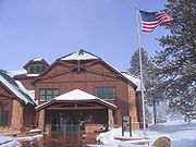
There are two campgrounds in the park, North Campground and Sunset Campground. Loop A in North Campground is open year-round. Additional loops and Sunset Campground are open from late spring to early autumn. The 114-room Bryce Canyon Lodge
Bryce Canyon Lodge
Bryce Canyon Lodge is a lodge in Bryce Canyon National Park, Utah. It was built between 1924 and 1925 using local materials. Designed by architect Gilbert Stanley Underwood, the lodge is an excellent example of National Park Service Rustic design...
is another way to overnight in the park.
A favorite activity of most visitors is landscape photography. With Bryce Canyon's high altitude and clean air, the sunrise and sunset photographs can be spectacular.
Further reading
- DeCourten, Frank. 1994. Shadows of Time, the Geology of Bryce Canyon National Park. Bryce Canyon Natural History Association.
- Kiver, Eugene P., Harris, David V. 1999. Geology of U.S. Parklands 5th ed. John Wiley & Sons, Inc.
- Sprinkel, Douglas A., Chidsey, Thomas C. Jr., Anderson, Paul B. 2000. Geology of Utah's Parks and Monuments. Publishers Press.
External links
- Bryce Canyon National Park Service Info / US Department of the Interior.
- Bryce Canyon National Park: Hoodoos Cast Their Spell, a National Park Service Teaching with Historic Places (TwHP) lesson plan
- Maps
- Bryce Canyon National Park - slideshow by Life magazine