
Canyons of the Ancients National Monument
Encyclopedia

U.S. state
A U.S. state is any one of the 50 federated states of the United States of America that share sovereignty with the federal government. Because of this shared sovereignty, an American is a citizen both of the federal entity and of his or her state of domicile. Four states use the official title of...
of Colorado
Colorado
Colorado is a U.S. state that encompasses much of the Rocky Mountains as well as the northeastern portion of the Colorado Plateau and the western edge of the Great Plains...
, and is managed by the U.S. Bureau of Land Management, an agency within the U.S. Department of the Interior. Created by a Presidential proclamation on June 9, 2000, the monument encompasses 164,000 acres (663 km²) and surrounds three of the four separate sections of Hovenweep National Monument
Hovenweep National Monument
Hovenweep National Monument is located on land in southwestern Colorado and southeastern Utah, located between Cortez, Colorado and Blanding, Utah on the Cajon Mesa of the Great Sage Plain...
, which is administered by the National Park Service
National Park Service
The National Park Service is the U.S. federal agency that manages all national parks, many national monuments, and other conservation and historical properties with various title designations...
. Canyons of the Ancients was set aside to preserve and protect the largest concentration of archeological sites in the United States. As of 2005, over 6,000 individual archeological sites had been identified within the monument.
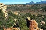
Geography
Canyons of the Ancients National Monument, located 9 miles west of Pleasant View, ColoradoPleasant View, Colorado
Pleasant View is an unincorporated town and a U.S. Post Office located in Montezuma County, Colorado, United States. The Pleasant View Post Office has the ZIP Code 81331....
in southwestern Colorado, encompasses 164,000 acres (663 km²). The monuments northern and eastern boundaries are canyons. Its western boundary is the Colorado-Utah state border. Lands south are bordered by the Ute Mountain Reservation
Ute Mountain Ute Tribe
The Ute Mountain Ute Tribe is one of three federally recognized tribes of the Ute Nation, and are mostly descendants of the historic Weeminuche Band who moved to the Southern Ute reservation in 1897...
and McElmo Creek
McElmo Creek
McElmo Creek is a tributary that joins the San Juan River in San Juan County, Utah. The creek's source is just east of Cortez in Montezuma County, Colorado.-See also:*List of rivers of Colorado*List of rivers of Utah...
.
Early people 8,000 BP to AD 750
Hunter-gather 8,000 B.P. to AD 1- Evidence from the nearby Hovenweep National MonumentHovenweep National MonumentHovenweep National Monument is located on land in southwestern Colorado and southeastern Utah, located between Cortez, Colorado and Blanding, Utah on the Cajon Mesa of the Great Sage Plain...
indicates that there were Paleo-Indians hunter-gathererHunter-gathererA hunter-gatherer or forage society is one in which most or all food is obtained from wild plants and animals, in contrast to agricultural societies which rely mainly on domesticated species. Hunting and gathering was the ancestral subsistence mode of Homo, and all modern humans were...
and people of the Archaic period as early as 8,000 years ago. The ancestors of the Mesa Verde Pueblo people hunted and lived in a difficult terrain, traversed deep canyons and areas of few animals and limited vegetation, and managed limited access to water - which made life difficult and limited the size of their hunt groups. They gathered seeds and fruit from wild plants to supplement their diet.
Basketmakers AD 1 to 550
- The people living in the Four Corners region were introduced to maizeMaizeMaize known in many English-speaking countries as corn or mielie/mealie, is a grain domesticated by indigenous peoples in Mesoamerica in prehistoric times. The leafy stalk produces ears which contain seeds called kernels. Though technically a grain, maize kernels are used in cooking as a vegetable...
and basketryBasket weavingBasket weaving is the process of weaving unspun vegetable fibres into a basket or other similar form. People and artists who weave baskets are called basketmakers and basket weavers.Basketry is made from a variety of fibrous or pliable materials•anything that will bend and form a shape...
through MesoamericaMesoamericaMesoamerica is a region and culture area in the Americas, extending approximately from central Mexico to Belize, Guatemala, El Salvador, Honduras, Nicaragua, and Costa Rica, within which a number of pre-Columbian societies flourished before the Spanish colonization of the Americas in the 15th and...
n trading about 2,000 years Before PresentBefore PresentBefore Present years is a time scale used in archaeology, geology, and other scientific disciplines to specify when events in the past occurred. Because the "present" time changes, standard practice is to use AD 1950 as the origin of the age scale, reflecting the fact that radiocarbon...
Able to have greater control of their diet through cultivation, the hunter-gatherers lifestyle became more sedentary as small disperse groups began cultivating maize and squash. They also continued to hunt and gather wild plants.
- They were named "Basketmakers" for their skill in making baskets for storing food, covering with pitch to heat water, and using to toast seeds and nuts. They wove bags, sandals, belts out of yucca plants and leaves - and strung beads. They occasionally lived in dry caves where they dug pits that they lined with stones to store food. These people were ancestors of the pueblo people of the Hovenweep pueblo settlement and Mesa Verde.
Modified Basketmakers AD 550 to 750
- This era resulted in the introduction of pottery which reduced the number of baskets that they made and eliminated the creation of woven bags. The simple, gray pottery allowed them a better tool for cooking and storage. Beans were added to the cultivated diet. Bows and arrows made hunting easier and thus the acquisition of hides for clothing. Turkey feathers were woven into blankets and robes. On the rim of Mesa Verde, small groups built pit houses which were built several feet below the surface with elements suggestive of the introduction of celebration rituals.
Canyons of the Ancients residents AD 750 to 1300
Developmental Pueblo AD 750 to 1100- Ancient Pueblo people lived in the Canyons of the Ancients in the 900s; Lowry Pueblo, built during the Great Pueblo period, was built atop pit-house built in the 900s.
- For a fuller understanding of the architecture and life style during this period, pueblo buildings in Mesa Verde were built with stone, windows facing south, and in U, E and L shapes. The buildings were located more closely together and reflected deepening religious celebration. Towers were built near kivas and likely used for look-outs. Pottery became more versatile, including pitchers, ladles, bowls, jars and dishware for food and drink. White pottery with black designs emerged, the pigments coming from plants. Water management and conservation techniques, including the use of reservoirs and silt-retaining dams also emerged during this period.
Great Pueblo period AD 1100 to 1300
- As refinements in construction techniques increased, the Puebloans built larger pueblos, or villages, on top of the pithouses starting about AD 1090. Lowry Pueblo had just a few rooms and 2 kivas in 1090 and the village was expanded two times about 1103 and 1120 until it had 40 rooms, 8 kivas and one great kiva.
- Like their ancient neighbors at Hovenweep National MonumentHovenweep National MonumentHovenweep National Monument is located on land in southwestern Colorado and southeastern Utah, located between Cortez, Colorado and Blanding, Utah on the Cajon Mesa of the Great Sage Plain...
and Mesa Verde National ParkMesa Verde National ParkMesa Verde National Park is a U.S. National Park and UNESCO World Heritage Site located in Montezuma County, Colorado, United States. It was created in 1906 to protect some of the best-preserved cliff dwellings in the world...
, the Lowry Pueblo dwellers were farmers and hunters. They grew beans, corn and squash and raised turkeys. They also made and decorated pottery.
Notable sites
- At least 6,000 distinct structures have been identified in the monument, and the density of archeological remains is the highest of any region in the United States. The vast majority of stone structures in the national monument are from the puebloan period.
- More than 20,000 sites have been identified, in some places more than 100 sites per square mile. After building basic pit style structures at first, the Puebloans later built villages with cliff dwellings. Archaeological ruins also include Sweat lodgeSweat lodgeThe sweat lodge is a ceremonial sauna and is an important event in some North American First Nations or Native American cultures...
s, kivas, shrines and petroglyphPetroglyphPetroglyphs are pictogram and logogram images created by removing part of a rock surface by incising, picking, carving, and abrading. Outside North America, scholars often use terms such as "carving", "engraving", or other descriptions of the technique to refer to such images...
s. Reservoirs with stone and earthen dams, including spillways and also numerous check dams, built in case of flash floods. Stone towers which may have been lookout or sentry posts, are found scattered throughout the monument.
| Pueblo | Photo | Comments |
|---|---|---|
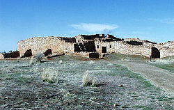
| Lowry Pueblo Lowry Pueblo The Lowry Pueblo is an Ancestral Puebloan archaeological site located in Canyons of the Ancients National Monument near Pleasant View, Colorado, United States. The pueblo was constructed about 1060 AD atop abandoned pithouses from an earlier period of occupation. It was occupied by 100 people... |
|
The Lowry Pueblo National Historic Landmark consists of 8 kivas, a great (community) kiva and 40 rooms built as high as three stories. The underground great kiva was built about AD 1103 and had murals painted over about 5 layers of plaster. About 1110 another kiva was built on top of the original kiva. Based upon the size of the kiva it's thought that the Lowry Pueblo may have been a local center for religious gatherings and celebration. |
| Painted Hand Pueblo | The Painted Hand Pueblo is a backcountry site that consists of unexcavated ruins built upon boulders along a cliff-face and a standing tower. The pueblo received its name from a boulder with pictographs of hands. | |
| Sand Canyon Pueblo | A very large open site, Sand Canyon Pueblo contains at least 420 rooms, 100 kivas, and 14 towers. The site was evidently chosen for a spring at the head of a small canyon. Excavations indicate that the pueblo was built to an architectural plan, and was constructed between 1250 and 1270. Additional residential rooms were added later. Distinct features include a D-shaped multiwalled structure and a great kiva, and characteristics which may be related to Chaco Canyon architecture. | |
Migration
- Unlike other Ancient Pueblo site abandonment, it appears that the people of the Canyons of the Ancients left the sites much earlier than their neighbors, some time in the mid-1100s. Some of the artifacts found from the site show a connection to the Chocaon culture, while others are similar to those of the Mesa Verde dwellers.
- Other Ancient Pueblo people from the area migrated south to Arizona and New Mexico, ancestors to modern pueblo people such as the Hopi and Zuni. Modern Pueblo people are located on reservations primarily in New Mexico, but some in Arizona. The 60,000 people's pueblos and reservations reside in three geographic areas:
-
- along the Rio Grande canyon in New Mexico, such as the Taos PuebloTaos PuebloTaos Pueblo is an ancient pueblo belonging to a Taos speaking Native American tribe of Pueblo people. It is approximately 1000 years old and lies about north of the modern city of Taos, New Mexico, USA...
- southern New Mexican Zuni, Acuna, Laguna and Isleta pueblos and reservations
- Arizona Hopi.
- along the Rio Grande canyon in New Mexico, such as the Taos Pueblo
-
Post-Pueblo Native American tribes AD 1300 to 1700s
After AD 1300 hunter-gathers, ancestors of the UteUte Tribe
The Ute are an American Indian people now living primarily in Utah and Colorado. There are three Ute tribal reservations: Uintah-Ouray in northeastern Utah ; Southern Ute in Colorado ; and Ute Mountain which primarily lies in Colorado, but extends to Utah and New Mexico . The name of the state of...
and Navajo
Navajo people
The Navajo of the Southwestern United States are the largest single federally recognized tribe of the United States of America. The Navajo Nation has 300,048 enrolled tribal members. The Navajo Nation constitutes an independent governmental body which manages the Navajo Indian reservation in the...
, moved into the southwestern Colorado
Colorado
Colorado is a U.S. state that encompasses much of the Rocky Mountains as well as the northeastern portion of the Colorado Plateau and the western edge of the Great Plains...
and southeastern Utah
Utah
Utah is a state in the Western United States. It was the 45th state to join the Union, on January 4, 1896. Approximately 80% of Utah's 2,763,885 people live along the Wasatch Front, centering on Salt Lake City. This leaves vast expanses of the state nearly uninhabited, making the population the...
and came to inhabit the region.
- The ancestors to the Navajo were one of the tribes of the southern division of the AthabaskanAthabaskan languagesAthabaskan or Athabascan is a large group of indigenous peoples of North America, located in two main Southern and Northern groups in western North America, and of their language family...
linguistic family that migrated south from Alaska and northwestern Canada, most likely traveling through the Great BasinGreat BasinThe Great Basin is the largest area of contiguous endorheic watersheds in North America and is noted for its arid conditions and Basin and Range topography that varies from the North American low point at Badwater Basin to the highest point of the contiguous United States, less than away at the...
. The Navajo ancestors were in the area after AD 1300, but at least by the early 1500s. - The people from who the Ute descended arrived in the area from the west in this period from 1300 to the 1700s. The Ute's ancestors are hunter-gatherers who in the 1100s began migrating east from the present southern California area into a large hunter-gathering territory as far east as the Great Plains and in the canyons and mountains of eastern Utah and Colorado.
During this period, the Spanish colonial reach extended to northern New Mexico, where they settled in the 1500s. They introduced items for trade, such as guns and horses, new and deadly diseases, and cultural influence in the forms of religion, language, and forms of government. In the 1700s Spanish
Spain
Spain , officially the Kingdom of Spain languages]] under the European Charter for Regional or Minority Languages. In each of these, Spain's official name is as follows:;;;;;;), is a country and member state of the European Union located in southwestern Europe on the Iberian Peninsula...
missionaries visited the area looking for a route to Spanish missions in California. One of the expeditions was that of Spanish friars Silvestre Vélez de Escalante and Francisco Atanasio Domínguez
Dominguez-Escalante Expedition
The Dominguez-Escalante Expedition was conducted in 1776 to find an overland route from Santa Fe, New Mexico to Spanish missions in California...
who traveled from New Mexico, through western Colorado to Utah.
European and American settlement 1800s to present
The first AngloAnglo
Anglo is a prefix indicating a relation to the Angles, England or the English people, as in the terms Anglo-Saxon, Anglo-American, Anglo-Celtic, Anglo-African and Anglo-Indian. It is often used alone, somewhat loosely, to refer to people of British Isles descent in The Americas, Australia and...
American people arrived in the early 1800s, staring with trappers. With the discovery of precious ores in the last decades of the 19th Century, minors and other settlers moved into the region. By the mid-1800s the United States government and Native American tribes were at war over land ownership. People were forced to leave their homelands. The Navajo
Navajo people
The Navajo of the Southwestern United States are the largest single federally recognized tribe of the United States of America. The Navajo Nation has 300,048 enrolled tribal members. The Navajo Nation constitutes an independent governmental body which manages the Navajo Indian reservation in the...
had moved south and the Ute
Ute Tribe
The Ute are an American Indian people now living primarily in Utah and Colorado. There are three Ute tribal reservations: Uintah-Ouray in northeastern Utah ; Southern Ute in Colorado ; and Ute Mountain which primarily lies in Colorado, but extends to Utah and New Mexico . The name of the state of...
territory was significantly reduced.
Excavation and restoration
Lowry Pueblo was excavated in 1928 and went through a restoration process in 1965. Two years later it was named a National Historic Landmark and was listed on the National Register of Historic places.National monument
Canyons of the Ancients National Monument- The U.S. Bureau of Land ManagementBureau of Land ManagementThe Bureau of Land Management is an agency within the United States Department of the Interior which administers America's public lands, totaling approximately , or one-eighth of the landmass of the country. The BLM also manages of subsurface mineral estate underlying federal, state and private...
administers the monument and enforces regulations balancing resource protection with land conservation. It was created by executive proclamation in 2000 with the intention of protecting the archaeological, natural and geological resources. Facilities at the Lowry Pueblo include a picnic area, toilet and trail. Sand Canyon Pueblo also has a trail, which leads to McElmo Canyon.
Wilderness study areas
- There are three Wilderness study areas in the monument:
-
- Cahone Canyon is located about 4 miles southwest of the town of Cahone, ColoradoCahone, ColoradoCahone is an unincorporated town and U.S. Post Office in Dolores County, Colorado, United States. The ZIP Code of the Cahone Post Office is 81320.-History:The town of Cahone was established about 1912. The Cahone Post Office opened on May 21, 1916...
is about 9,156 acres. The wilderness area, varying from 5900 to 6000 ft (1,798.3 to 1,828.8 m) in elevation, consists of three canyons, piñon-juniper woodland, and two ecosystems: riparian and sagebrush. - Cross Canyon is located south of Cahone Canyon, about 14 miles southwest of the town of Cahone, ColoradoCahone, ColoradoCahone is an unincorporated town and U.S. Post Office in Dolores County, Colorado, United States. The ZIP Code of the Cahone Post Office is 81320.-History:The town of Cahone was established about 1912. The Cahone Post Office opened on May 21, 1916...
is about 12,721 acres, 1,008 acres cross into Utah. The wilderness area, varying from 5140 to 6500 ft (1,566.7 to 1,981.2 m) in elevation, consists of three canyons (Cross, Ruin and Cow), piñon-juniper woodland and riparian and sagebrush ecosystems. - Squaw/Papoose Canyon is located about 12 miles south of Dove Creek and is about 11,357 acres, 6,676 acres cross into Utah. The wilderness area, varying from 5300 to 6600 ft (1,615.4 to 2,011.7 m) in elevation, consists of two canyons (Squaw and Papoose).
- Cahone Canyon is located about 4 miles southwest of the town of Cahone, Colorado
-
Anasazi Heritage Center and Canyons of the Ancients visitor center
- The Anasazi Heritage CenterAnasazi Heritage CenterAnasazi Heritage Center, located in Dolores, Colorado, is an archaeological museum of Native American pueblo and hunter-gatherer cultures. Two 12th-century archaeological sites, the Escalante and Dominguez Pueblos, at the center were once home to Ancient Pueblo Peoples...
is also the visitor center for the Canyons of the Ancients National Monument and includes artifacts from the monument, museum with interactive exhibits, library and theatre. Information is available there regarding the Ancient Puebloan culture, Trail of the Ancients Byway and the Canyons of the Ancients National Monument.
Vandalism
- Vandalism and treasure hunting are difficult to minimize due to an inadequate number of federal employees and law enforcement personnel to monitor and prosecute those who deface ruins or steal archeological remains. Thousands of undocumented artifacts have been removed from the monument and now reside in private collections. A news article in July 2006 reported that funding for the monument had decreased by almost 40% since 2004, and that a particularly severe looting episode occurred in January 2006.
Geology and topography
The northern part of the Monument in part has gently sloping, relatively even surfaces ranging in elevation from about 6700 feet (2,042.2 m) in the east to about 6000 to 5500 ft (1,828.8 to 1,676.4 m) in the west. These surfaces are upheld by sedimentary rocks of CretaceousCretaceous
The Cretaceous , derived from the Latin "creta" , usually abbreviated K for its German translation Kreide , is a geologic period and system from circa to million years ago. In the geologic timescale, the Cretaceous follows the Jurassic period and is followed by the Paleogene period of the...
age that are mostly covered by much younger gravel and sand layers deposited in the last several million years. The region is incised by canyons that drain south and west to McElmo Creek
McElmo Creek
McElmo Creek is a tributary that joins the San Juan River in San Juan County, Utah. The creek's source is just east of Cortez in Montezuma County, Colorado.-See also:*List of rivers of Colorado*List of rivers of Utah...
; the creek falls from the east at about 5800 to 4800 ft (1,767.8 to 1,463 m) west at the Utah
Utah
Utah is a state in the Western United States. It was the 45th state to join the Union, on January 4, 1896. Approximately 80% of Utah's 2,763,885 people live along the Wasatch Front, centering on Salt Lake City. This leaves vast expanses of the state nearly uninhabited, making the population the...
border. The oldest rocks are exposed in McElmo Canyon and are sedimentary layers of Jurassic
Jurassic
The Jurassic is a geologic period and system that extends from about Mya to Mya, that is, from the end of the Triassic to the beginning of the Cretaceous. The Jurassic constitutes the middle period of the Mesozoic era, also known as the age of reptiles. The start of the period is marked by...
age. In and near the Monument, these sedimentary rocks have been bent upwards to form a dome, the McElmo Dome: most of the Jurassic rocks are below the surface in the regions immediately bordering the area. The southern boundary of much of the Monument lies just north of McElmo Creek. The Ute Mountains to the south are cored by igneous intrusions and rise to 9979 feet (3,041.6 m).
Formations from the Cretaceous and Jurassic periods
The following description of the geology of the Monument is derived mostly from contributions to Anderson et al. (1997), unless otherwise referenced. The nomenclature of the rock units here may not represent the present consensus. The sedimentary sequence is over 1500 feet (457.2 m) thick and is represented by the stratigraphic units listed below.
| Geological period | Formation | Rock | Approx. Depth | Comments |
|---|---|---|---|---|
| Cretaceous (145.5–65.5 million years ago) | Dakota Sandstone Dakota Sandstone The Dakota Sandstone is a general term for an ill-defined early Cretaceous formation of the Rocky Mountains and Great Plains. It consists of sandy, shallow-marine deposits with intermittent mud flat sediments, and occasional stream deposits... |
Mostly sandstone, locally with conglomerate Conglomerate (geology) A conglomerate is a rock consisting of individual clasts within a finer-grained matrix that have become cemented together. Conglomerates are sedimentary rocks consisting of rounded fragments and are thus differentiated from breccias, which consist of angular clasts... and thin beds of shale Shale Shale is a fine-grained, clastic sedimentary rock composed of mud that is a mix of flakes of clay minerals and tiny fragments of other minerals, especially quartz and calcite. The ratio of clay to other minerals is variable. Shale is characterized by breaks along thin laminae or parallel layering... and coal Coal Coal is a combustible black or brownish-black sedimentary rock usually occurring in rock strata in layers or veins called coal beds or coal seams. The harder forms, such as anthracite coal, can be regarded as metamorphic rock because of later exposure to elevated temperature and pressure... . |
100 feet (30.5 m) | It was deposited during the Cretaceous Cretaceous The Cretaceous , derived from the Latin "creta" , usually abbreviated K for its German translation Kreide , is a geologic period and system from circa to million years ago. In the geologic timescale, the Cretaceous follows the Jurassic period and is followed by the Paleogene period of the... Period (about 95 million years ago). Flaked tools Flake tool In archaeology a flake tool is a type of stone tool created by striking a flake from a prepared stone core.The flake could be sharpened by retouch to create scrapers or burins.-References:... have been made from chert Chert Chert is a fine-grained silica-rich microcrystalline, cryptocrystalline or microfibrous sedimentary rock that may contain small fossils. It varies greatly in color , but most often manifests as gray, brown, grayish brown and light green to rusty red; its color is an expression of trace elements... clasts extracted from the conglomerate (Gerhardt et al.). |
| Burro Canyon Formation | Mostly sandstone Sandstone Sandstone is a sedimentary rock composed mainly of sand-sized minerals or rock grains.Most sandstone is composed of quartz and/or feldspar because these are the most common minerals in the Earth's crust. Like sand, sandstone may be any colour, but the most common colours are tan, brown, yellow,... , siltstone Siltstone Siltstone is a sedimentary rock which has a grain size in the silt range, finer than sandstone and coarser than claystones.- Description :As its name implies, it is primarily composed of silt sized particles, defined as grains 1/16 - 1/256 mm or 4 to 8 on the Krumbein phi scale... , and mudstone Mudstone Mudstone is a fine grained sedimentary rock whose original constituents were clays or muds. Grain size is up to 0.0625 mm with individual grains too small to be distinguished without a microscope. With increased pressure over time the platey clay minerals may become aligned, with the... , formed from river deposits, and it is similar to the Dakota Sandstone but lacks coal beds. |
100 feet (30.5 m), but highly variable. | Silicified Petrifaction In geology, petrifaction, petrification or silicification is the process by which organic material is converted into stone by impregnation with silica. It is a rare form of fossilization... sandstone in this unit has been used to make flaked tools (Gerhardt et al.). |
|
| Jurassic (199.6–145.5 million years ago) | Morrison Formation Morrison Formation The Morrison Formation is a distinctive sequence of Late Jurassic sedimentary rock that is found in the western United States, which has been the most fertile source of dinosaur fossils in North America. It is composed of mudstone, sandstone, siltstone and limestone and is light grey, greenish... |
Parts of this ash altered to zeolite Zeolite Zeolites are microporous, aluminosilicate minerals commonly used as commercial adsorbents. The term zeolite was originally coined in 1756 by Swedish mineralogist Axel Fredrik Cronstedt, who observed that upon rapidly heating the material stilbite, it produced large amounts of steam from water that... s and chalcedony Chalcedony Chalcedony is a cryptocrystalline form of silica, composed of very fine intergrowths of the minerals quartz and moganite. These are both silica minerals, but they differ in that quartz has a trigonal crystal structure, while moganite is monoclinic... have been used to make flaked tools. The is made mostly of siltstone and sandstone formed from river and lake deposits. Some layers are made from volcanic ash Volcanic ash Volcanic ash consists of small tephra, which are bits of pulverized rock and glass created by volcanic eruptions, less than in diameter. There are three mechanisms of volcanic ash formation: gas release under decompression causing magmatic eruptions; thermal contraction from chilling on contact... .(Gerhardt et al.). |
600 feet (182.9 m) | Elsewhere in the Morrison Formation, many fossils of large dinosaurs have been found, as have deposits of uranium Uranium Uranium is a silvery-white metallic chemical element in the actinide series of the periodic table, with atomic number 92. It is assigned the chemical symbol U. A uranium atom has 92 protons and 92 electrons, of which 6 are valence electrons... and vanadium Vanadium Vanadium is a chemical element with the symbol V and atomic number 23. It is a hard, silvery gray, ductile and malleable transition metal. The formation of an oxide layer stabilizes the metal against oxidation. The element is found only in chemically combined form in nature... . |
| Bluff Sandstone (also called Junction Creek Sandstone) | In part it formed from a great deposit of windblown sand (an erg Erg (landform) An erg is a broad, flat area of desert covered with wind-swept sand with little or no vegetative cover. The term takes its name from the Arabic word ʿarq , meaning "dune field"... ). |
250 feet (76.2 m) | Elsewhere well-preserved dinosaur tracks have been found in rocks of this unit. | |
| Summerville Formation Summerville Formation The Summerville Formation is a geological formation in New Mexico, Colorado, and Utah of the Southwestern United States. It dates back to the Middle Jurassic.-Dinosaurs:Theropod tracks geographically located in Utah, New Mexico, and Colorado, USA.... (also called Wanakah Formation) |
Mostly siltstone and sandstone. | 100 feet (30.5 m) | ||
| Entrada Sandstone Entrada Sandstone The Entrada Sandstone is a formation in the San Rafael Group that is spread across the U.S. states of Wyoming, Colorado, northwest New Mexico, northeast Arizona and southeast Utah... |
Consists of about 30 feet of red siltstone that commonly weathers to a knobby surface, overlain by about 80 feet of sandstone. | 110 feet (33.5 m) | Cliff dwellings and other structures are common in alcoves in this sandstone. | |
| Navajo Sandstone Navajo Sandstone Navajo Sandstone is a geologic formation in the Glen Canyon Group that is spread across the U.S. states of northern Arizona, northwest Colorado, and Utah; as part of the Colorado Plateau province of the United States... |
Formed from wind-blown sand. | 100 feet (30.5 m) | The trail head at Sand Canyon near McElmo Creek McElmo Creek McElmo Creek is a tributary that joins the San Juan River in San Juan County, Utah. The creek's source is just east of Cortez in Montezuma County, Colorado.-See also:*List of rivers of Colorado*List of rivers of Utah... is on rocks of this unit. |
|
| Kayenta Formation Kayenta Formation The Kayenta Formation is a geologic layer in the Glen Canyon Group that is spread across the Colorado Plateau province of the United States, including northern Arizona, northwest Colorado, Nevada, and Utah. This rock formation is particularly prominent in southeastern Utah, where it is seen in the... |
Sandstone formed from stream deposits. | 20 to 30 ft (6.1 to 9.1 m) | ||
| Wingate Sandstone Wingate Sandstone Wingate Sandstone is a geologic formation in the Glen Canyon Group that is spread across the Colorado Plateau province of the United States, including northern Arizona, northwest Colorado, Nevada, and Utah. This rock formation is particularly prominent in southeastern Utah, where it forms... |
Formed from wind-blown sand. | At least 170 feet (51.8 m) | It was deposited about 190 million years ago. | |
Carboniferouse Period
Carbon dioxide
Carbon dioxide
Carbon dioxide is a naturally occurring chemical compound composed of two oxygen atoms covalently bonded to a single carbon atom...
is produced from rocks of Mississippian age (Carboniferous Period
359.2–299 million years ago) in the McElmo Dome, from wells drilled to a depth of about 8000 feet (2,438.4 m). The dome contains one of the largest deposits of carbon dioxide in the United States, and the extracted gas is used for enhanced oil recovery. This carbon dioxide reservoir has been studied to learn about possible underground storage (carbon sequestration) of carbon dioxide (Stevens et al., 2001).
Oil and gas exploration
In 1986 the area was designated as the Anasazi Area of Critical Environmental Concern by the Bureau of Land ManagementBureau of Land Management
The Bureau of Land Management is an agency within the United States Department of the Interior which administers America's public lands, totaling approximately , or one-eighth of the landmass of the country. The BLM also manages of subsurface mineral estate underlying federal, state and private...
to ensure there are no new leases for oil and gas industry; Leases will only be given to promote the conservation of oil and gas resources.
85% of the monument was under lease by ranchers and oil and gas exploration entities in the year 2000. With only 2,000 acres of monument land that is not leased, and that land home to ancient archaeological sites and wildlife habitat, four environmental groups have been active to ensure there is no further oil and gas exploration and extraction. However, off road vehicles and an increase in road construction for oil and gas exploration, allow greater access to archeological areas. Large trucks, known as "thumpers" were found searching for oil and gas pockets by pounding the earth and recording the seismic data, having received a "green light" from the Bureau of Land Management. Executive Director of the San Juan Citizens Alliance, Mark Pearson stated:
The decision showed a blatant disregard for the proclamation [that states that leases should only be made to protect and preserve oil and gas resources]. That does not bode well for the future management for the rest of this monument or any monument in the country.
In 2006 the National Trust for Historic Preservation reported that the nation's push for energy resources on federal land is occurring at a cost of archaeological and cultural resources at Canyons of the Ancients National Monument and Utah's Nine Mile Canyon
Nine Mile Canyon
Nine Mile Canyon is a canyon, approximately long, located in the counties of Carbon and Duchesne in eastern Utah, in the Western United States. Promoted as "the world’s longest art gallery," the canyon is known for its extensive rock art, most of it created by the Fremont culture and the Ute people...
. The National Trust further asserted that the Bureau of Land Management has only documented 17 million acres of the 262 under its stewardship.
Ken Salazar, Secretary of Interior said in 2009:
With an emphasis on conservation, protection and restoration, the National Landscape Conservation System and Canyons of the Ancients National Monument represent a new era of management for the BLM. After 130 years of exploration and research identifying tens of thousands of irreplaceable and fragile archaeological sites, we know that Canyons of the Ancients represents the best of our cultural heritage. Using an army of volunteers who contribute on the ground services and applying the principles of balanced management and science-based decision-making, this crown jewel preserves ancestral homes and landscapes for Native American citizens and for children and communities throughout the United States.
Wildlife
The Monument is home to a wide variety of desert wildlife, some of which are the American kestrelAmerican Kestrel
The American Kestrel , sometimes colloquially known as the Sparrow Hawk, is a small falcon, and the only kestrel found in the Americas. It is the most common falcon in North America, and is found in a wide variety of habitats. At long, it is also the smallest falcon in North America...
s, Gambel’s quail, Golden eagle
Golden Eagle
The Golden Eagle is one of the best known birds of prey in the Northern Hemisphere. Like all eagles, it belongs to the family Accipitridae. Once widespread across the Holarctic, it has disappeared from many of the more heavily populated areas...
s, Long-Nosed Leopard lizard, Mesa Verde nightsnake
Hypsiglena torquata
Hypsiglena torquata is a species of rear-fanged, colubrid snake known as the night snake. They are found through the south and western United States, as well as Mexico...
, mourning dove, Peregrine falcon
Peregrine Falcon
The Peregrine Falcon , also known as the Peregrine, and historically as the Duck Hawk in North America, is a widespread bird of prey in the family Falconidae. A large, crow-sized falcon, it has a blue-gray back, barred white underparts, and a black head and "moustache"...
s, Red-tailed hawk
Red-tailed Hawk
The Red-tailed Hawk is a bird of prey, one of three species colloquially known in the United States as the "chickenhawk," though it rarely preys on standard sized chickens. It breeds throughout most of North America, from western Alaska and northern Canada to as far south as Panama and the West...
s the Twin-spotted Spiny Lizard. Mammals that pass through the riparian and piñon-juniper woodland are jackrabbits, Mule deer
Mule Deer
The mule deer is a deer indigenous to western North America. The Mule Deer gets its name from its large mule-like ears. There are believed to be several subspecies, including the black-tailed deer...
, ringtail, fox
Fox
Fox is a common name for many species of omnivorous mammals belonging to the Canidae family. Foxes are small to medium-sized canids , characterized by possessing a long narrow snout, and a bushy tail .Members of about 37 species are referred to as foxes, of which only 12 species actually belong to...
, muskrat
Muskrat
The muskrat , the only species in genus Ondatra, is a medium-sized semi-aquatic rodent native to North America, and introduced in parts of Europe, Asia, and South America. The muskrat is found in wetlands and is a very successful animal over a wide range of climates and habitats...
, beaver
Beaver
The beaver is a primarily nocturnal, large, semi-aquatic rodent. Castor includes two extant species, North American Beaver and Eurasian Beaver . Beavers are known for building dams, canals, and lodges . They are the second-largest rodent in the world...
and bobcat
Bobcat
The bobcat is a North American mammal of the cat family Felidae, appearing during the Irvingtonian stage of around 1.8 million years ago . With twelve recognized subspecies, it ranges from southern Canada to northern Mexico, including most of the continental United States...
.
Wildlife and plant habitat are threatened by increased road and building construction by oil and gas interests.
See also
Other neighboring Ancient Pueblo sites in Colorado- Anasazi Heritage CenterAnasazi Heritage CenterAnasazi Heritage Center, located in Dolores, Colorado, is an archaeological museum of Native American pueblo and hunter-gatherer cultures. Two 12th-century archaeological sites, the Escalante and Dominguez Pueblos, at the center were once home to Ancient Pueblo Peoples...
- Crow Canyon Archaeological CenterCrow Canyon Archaeological CenterCrow Canyon Archaeological Center is an archeological center of training programs for students and teachers, located in Southwestern Colorado, USA...
- Hovenweep National MonumentHovenweep National MonumentHovenweep National Monument is located on land in southwestern Colorado and southeastern Utah, located between Cortez, Colorado and Blanding, Utah on the Cajon Mesa of the Great Sage Plain...
- Mesa Verde National ParkMesa Verde National ParkMesa Verde National Park is a U.S. National Park and UNESCO World Heritage Site located in Montezuma County, Colorado, United States. It was created in 1906 to protect some of the best-preserved cliff dwellings in the world...
Other cultures in the Four Corners region
- Trail of the AncientsTrail of the AncientsThe Trail of the Ancients is an National Scenic Byway located in the states of Colorado and Utah. The route highlights the archaeological and cultural history of southwestern Native American peoples, and traverses the widely diverse geological landscape of the Four Corners region...
- List of ancient dwellings of Pueblo peoples
Early American cultures
- List of prehistoric sites in Colorado
- Ancient Pueblo PeoplesAncient Pueblo PeoplesAncient Pueblo People or Ancestral Pueblo peoples were an ancient Native American culture centered on the present-day Four Corners area of the United States, comprising southern Utah, northern Arizona, northwest New Mexico, and southern Colorado...
- Oasisamerica culturesOasisamericaOasisamerica was a broad cultural area in pre-Columbian southwestern North America. It extended from modern-day Utah down to southern Chihuahua, and from the coast on the Gulf of California eastward to the Río Bravo river valley...
- Paleo-Indians