

Colorado National Monument
Encyclopedia
Trails
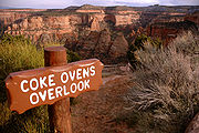
Serpents Trail, perhaps the most popular, follows the route of the original road to the top of the Monument. This trail is accessible by parking lots at both ends, both located off Rim Rock Drive. Serpents Trail is well-maintained and provides stunning views of both the Monument itself and the Grand Valley below. One of the shortest trails, also popular, is Devil's Kitchen. The trailhead is located near the eastern entrance of the park on Rim Rock Drive. This trail is about 1 mile long, and ends in a sandstone grotto. Devil's Kitchen trail is well suited for families with smaller children, as the hike is short and the "kitchen" itself provides plenty of opportunity for child-sized exploration.
Liberty Cap trail starts from the valley floor and climbs to the rim of the Monument. Liberty Cap itself is an ancient sand dune
Dune
In physical geography, a dune is a hill of sand built by wind. Dunes occur in different forms and sizes, formed by interaction with the wind. Most kinds of dunes are longer on the windward side where the sand is pushed up the dune and have a shorter "slip face" in the lee of the wind...
, and provides a beautiful view of the Grand Valley. Corkscrew Trail, closed for many years but re-opened in mid-2006, branches off the Liberty Cap and skirts a small canyon and cliffs that cannot be seen from the valley floor. This trail, the only loop trail on the Monument, is about 3 miles long and features a less rigorous climb than Liberty Cap.
Monument Canyon trail, also popular, follows Monument Canyon for about 5 miles. This trail is often hiked up-and-back, and provides close-up views of Independence Monument, the Colorado National Monument's most distinct feature. The lower trailhead is accessible from CO 340 (Broadway).
No Thoroughfare Trail starts at the bottom of No Thoroughfare Canyon, near the east entrance. As the name implies, there is no official trail to the top of this canyon. The dead-end trail goes a few miles into the canyon, and up-and-back hiking is required. Some hikers have found a way to get through the entire canyon, but after a certain point the trail becomes difficult and unmarked. No Thoroughfare Canyon does have small waterfalls during the spring run-off, but is dry for most of the year.
Historic preservation
Many of the early visitor facilities at Colorado National Monument were designed by the National Park Service and constructed by the Public Works AdministrationPublic Works Administration
The Public Works Administration , part of the New Deal of 1933, was a large-scale public works construction agency in the United States headed by Secretary of the Interior Harold L. Ickes. It was created by the National Industrial Recovery Act in June 1933 in response to the Great Depression...
and the Civilian Conservation Corps
Civilian Conservation Corps
The Civilian Conservation Corps was a public work relief program that operated from 1933 to 1942 in the United States for unemployed, unmarried men from relief families, ages 18–25. A part of the New Deal of President Franklin D...
. Several of these areas have been placed on the National Register of Historic Places
National Register of Historic Places
The National Register of Historic Places is the United States government's official list of districts, sites, buildings, structures, and objects deemed worthy of preservation...
in recognition of this and in consequence of their adherence to the National Park Service Rustic
National Park Service Rustic
National Park Service rustic, also colloquially known as Parkitecture, is a style of architecture that arose in the United States National Park System to create buildings that harmonized with their natural environment. Since its founding, the National Park Service consistently has sought to provide...
design standards of the time. The entire Rim Rock Drive is a National Historic District, as well as the Serpents Trail
Serpents Trail
The Serpents Trail in Colorado National Monument, also known as the Trail of the Serpents and the Serpentine Trail, was built by the visionary John Otto, who began the campaign to establish the national monument...
, the Devils Kitchen Picnic Shelter
Devils Kitchen Picnic Shelter
The Devils Kitchen Picnic Shelter in Colorado National Monument was designed by Harvey H. Cornell, Jerome C. Miller and Kenneth M. Saunders of the National Park Service Branch of Plans and Design in 1940. It was built by workers from the Civilian Conservation Corps and the Public Works...
, and three places in the Saddlehorn area: the Saddlehorn Caretaker's House and Garage
Saddlehorn Caretaker's House and Garage
The Saddlehorn Caretaker's House and Garage, also known as the Stone House, the Rock House and the Superintendent's Quarters is a house in Colorado National Monument...
, Saddlehorn Comfort Station
Saddlehorn Comfort Station
The Saddlehorn Comfort Station is one of a group of related structures listed on the National Register of Historic Places in Colorado National Monument...
, and the Saddlehorn Utility Area Historic District
Saddlehorn Utility Area Historic District
The Saddlehorn Utility Area Historic District in Colorado National Monument comprises a complex of park service buildings, designed by the National Park Service Branch of Plans and Designs in the National Park Service Rustic style. The primary designer was National Park Service architect Kenneth M...
. The Visitor Center complex
Colorado National Monument Visitor Center Complex
The Colorado National Monument Visitor Center Complex in Colorado National Monument is an example of the park services facilities designed and built as part of the Mission 66 program...
is also included as an example of the Mission 66
Mission 66
Mission 66 was a US National Park Service ten-year program that was intended to dramatically expand Park Service visitor services by 1966, in time for the 50th anniversary of the establishment of the Park Service....
program.
Geology
The park's geologic record preserves three different groups of rock and sediment. The oldest rocks are Early to Middle ProterozoicProterozoic
The Proterozoic is a geological eon representing a period before the first abundant complex life on Earth. The name Proterozoic comes from the Greek "earlier life"...
gneiss
Gneiss
Gneiss is a common and widely distributed type of rock formed by high-grade regional metamorphic processes from pre-existing formations that were originally either igneous or sedimentary rocks.-Etymology:...
and schist
Schist
The schists constitute a group of medium-grade metamorphic rocks, chiefly notable for the preponderance of lamellar minerals such as micas, chlorite, talc, hornblende, graphite, and others. Quartz often occurs in drawn-out grains to such an extent that a particular form called quartz schist is...
, including the Ute Canyon Stock. Overlying these, and separated by an angular unconformity
Unconformity
An unconformity is a buried erosion surface separating two rock masses or strata of different ages, indicating that sediment deposition was not continuous. In general, the older layer was exposed to erosion for an interval of time before deposition of the younger, but the term is used to describe...
, are mostly horizontally bedded Mesozoic
Mesozoic
The Mesozoic era is an interval of geological time from about 250 million years ago to about 65 million years ago. It is often referred to as the age of reptiles because reptiles, namely dinosaurs, were the dominant terrestrial and marine vertebrates of the time...
sedimentary rocks, including the cliff-forming
Cliff-former
The term cliff-former is a geologic term indicating that a unit of bedrock is more resistant to erosion than overlying or underlying units and consequently outcrops have high slope angles. It is more or less equivalent to ridge-former, and may be contrasted with slope-former. In humid...
Wingate Sandstone
Wingate Sandstone
Wingate Sandstone is a geologic formation in the Glen Canyon Group that is spread across the Colorado Plateau province of the United States, including northern Arizona, northwest Colorado, Nevada, and Utah. This rock formation is particularly prominent in southeastern Utah, where it forms...
. Overlying these are various types of Quaternary
Quaternary
The Quaternary Period is the most recent of the three periods of the Cenozoic Era in the geologic time scale of the ICS. It follows the Neogene Period, spanning 2.588 ± 0.005 million years ago to the present...
unconsolidated deposits such as alluvium
Alluvium
Alluvium is loose, unconsolidated soil or sediments, eroded, deposited, and reshaped by water in some form in a non-marine setting. Alluvium is typically made up of a variety of materials, including fine particles of silt and clay and larger particles of sand and gravel...
, colluvium
Colluvium
Colluvium is the name for loose bodies of sediment that have been deposited or built up at the bottom of a low-grade slope or against a barrier on that slope, transported by gravity. The deposits that collect at the foot of a steep slope or cliff are also known by the same name. Colluvium often...
, and dunes. The sedimentary rocks are folded
Fold (geology)
The term fold is used in geology when one or a stack of originally flat and planar surfaces, such as sedimentary strata, are bent or curved as a result of permanent deformation. Synsedimentary folds are those due to slumping of sedimentary material before it is lithified. Folds in rocks vary in...
into monocline
Monocline
A monocline is a step-like fold in rock strata consisting of a zone of steeper dip within an otherwise horizontal or gently-dipping sequence.-Formation:Monoclines may be formed in several different ways...
s by several faults, including the Redlands Thrust Fault.