

Lake Superior
Encyclopedia
Lake Superior is the largest of the five traditionally-demarcated Great Lakes
of North America
. It is bounded to the north by the Canadian province of Ontario
and the U.S. state
of Minnesota
, and to the south by the U.S. states of Wisconsin
and Michigan
. It is the largest freshwater lake in the world by surface area if Lake Huron and Lake Michigan are considered to be two lakes. It is the world's third-largest freshwater lake by volume.
wrote the name as "Gitche Gumee" in The Song of Hiawatha
, as did Gordon Lightfoot
in his song, "The Wreck of the Edmund Fitzgerald
". The first French
explorers approaching the great inland sea by way of the Ottawa River and Lake Huron during the 17th century referred to their discovery as le lac superieur. Properly translated, the expression means "Upper Lake," that is, the lake above Lake Huron. The lake was also called Lac Tracy by 17th century Jesuit missionaries. The English, upon taking control of the region from the French in the 1760's, following the French and Indian War
, anglicized the lake's name to Superior, "on account of its being superior in magnitude to any of the lakes on that vast continent."
via the St. Marys River
and the Soo Locks
. Lake Superior is the largest freshwater lake in the world based on surface area (if Lakes Michigan
and Huron
are taken separately (but, see Lake Michigan-Huron
)), and the third largest in volume, behind Lake Baikal
in Russia
and Lake Tanganyika
in Africa
. The Caspian Sea
, while larger than Lake Superior in both surface area and volume, is brackish; though presently isolated, historically the Caspian has been repeatedly connected to and isolated from the Mediterranean via the Black Sea
.
Lake Superior has a surface area of 31700 square miles (82,103 km²), which is approximately the size of South Carolina
. It has a maximum length of 350 smi and maximum breadth of 160 smi. Its average depth is 80.5 fathom (483 ft; 147 m) with a maximum depth of 222 fathom (1,332 ft; 406 m). Lake Superior contains 2,900 cubic miles (12,100 km³) of water. There is enough water in Lake Superior to cover the entire land mass
of North
and South America
with 1 feet (30.5 cm) of water. The shoreline of the lake stretches 2726 miles (4,387 km) (including islands).
American limnologist
J. Val Klump
was the first person to reach the lowest depth of Lake Superior on July 30, 1985, as part of a scientific expedition, which, at 733 feet (223.4 m) below sea level, is the lowest spot on the continental interior of the United States
and the second-lowest spot on the interior of the North America
n continent after the deeper Great Slave Lake
in Canada
(1503 feet (458.1 m) below sea level). (Though Crater Lake
, not Lake Superior, is the deepest lake in the United States, Crater Lake's surface elevation is much higher and its deepest point is 4229 feet (1,289 m) above sea level.)
While the temperature of the surface of the lake varies seasonally, the temperature below 660 feet (201.2 m) is an almost constant 39°F (4°C). This variation in temperature makes the lake seasonally stratigraphic
. Twice per year, however, the water column reaches a uniform temperature of 39°F (4°C) from top to bottom, and the lake waters are able to completely mix. This feature makes the lake dimictic. Because of its size Superior has a retention time
of 191 years.
Annual storms on Lake Superior regularly record wave heights of over 20 feet (6 m). Waves well over 30 feet (9 m) have been recorded.
, the St. Louis River
, the Pigeon River
, the Pic River
, the White River
, the Michipicoten River
, the Bois Brule River
and the Kaministiquia River
. Lake Superior drains into Lake Huron
by the St. Marys River. The rapids on the river necessitate the Sault Locks
, a part of the Great Lakes Waterway
, to move boats over the 25 feet (8 m) height difference from Lake Huron.
 The lake's average surface elevation is 600 feet (183 m) above sea level
. Until approximately 1887 the natural hydraulic conveyance through the St. Marys River
rapids determined outflow from Lake Superior. By 1921 development in support of transportation and hydropower resulted in gates, locks, power canals and other control structures completely spanning St. Marys rapids. The regulating structure is known as the Compensating Works and is operated according to a regulation plan known as Plan 1977-A. The current water levels, including diversions of water from the Hudson Bay
watershed, are governed by the International Lake Superior Board of Control which was established in 1914 by the International Joint Commission
.
Superior's water levels temporarily reached a new low in September 2007, slightly less than the previous record low in 1926. However, the water levels returned within a few days.
Historic High Water
The lake fluctuates from month to month with the highest lake levels in October and November. The normal highwater mark is 1.17 foot (0.356616 m) above datum (601.1 ft or 183.2 m). In the summer of 1985, Lake Superior reached its highest level at 2.33 foot (0.710184 m) above datum. The winter of 1986 set new highwater records through the winter and spring months (January - June), ranging from 1.33 foot (0.405384 m) to 1.833 foot (0.5586984 m) above Chart Datum.
Historic Low Water
The lake fluctuates from month to month with the lowest lake levels in March and April. The normal lowwater mark is 0.33 foot (0.100584 m) below datum (601.1 ft or 183.2 m). In the winter of 1926 Lake Superior reached its lowest level at 1.58 foot (0.481584 m) below datum. Additionally, the entire first half of the year (January - June) saw record low months. The low water was a continuation of the dropping lake levels from the previous year, 1925; which set lowwater records for October through December. During this nine-month period (Oct 1925-June 1926) water levels ranged from 1.58 foot (0.481584 m) to 0.33 foot (0.100584 m) below Chart Datum. In the summer of 2007 monthly historic lows were set; August at 0.66 foot (0.201168 m), September at 0.58 foot (0.176784 m).
, Lake Superior may have warmed faster than its surrounding climate. Summer surface temperatures in the lake appeared to have increased by about 4.5 °F (2.5 °C) since 1979, compared with an approximately 2.7 °F (1.5 °C) increase in the surrounding average air temperature. The increase in the lake’s surface temperature may be related to the decreasing ice cover. Less winter ice cover allows more solar radiation to penetrate the lake and warm the water. If trends continue Lake Superior, which freezes over completely once every 20 years, could routinely be ice-free by 2040. These warmer temperatures can actually lead to more snow in the lake effect snow belts along the shores of the lake, especially in the Upper Peninsula of Michigan
.
in the state of Michigan
. Isle Royale contains several lakes, some of which also contain islands. Other large famous islands include Madeline Island
in the state of Wisconsin
, Michipicoten Island
in the province of Ontario
, and Grand Island (location of the Grand Island National Recreation Area
) in the state of Michigan
.
The larger cities on Lake Superior include: the twin ports of Duluth, Minnesota
, and Superior, Wisconsin
; Thunder Bay
, Ontario
; Marquette, Michigan
; and the twin cities of Sault Ste. Marie, Michigan
, and Sault Ste. Marie, Ontario
. Duluth, at the western tip of Lake Superior, is the most inland point on the St. Lawrence Seaway and the most inland port in the world.
Among the scenic places on the lake are: the Apostle Islands National Lakeshore
, Isle Royale National Park
, Porcupine Mountains Wilderness State Park, Pukaskwa National Park
, Lake Superior Provincial Park
, Grand Island National Recreation Area
, Sleeping Giant (Ontario)
and Pictured Rocks National Lakeshore
.
is a designated scenic road system connecting all of the Great Lakes and the St. Lawrence River.
or maritime climate (more typically seen in locations like Nova Scotia
). The water surface's slow reaction to temperature changes, seasonally ranging between 32 and 55 °F (0-13 °C) around 1970, helps to moderate surrounding air temperatures in the summer and winter, and creates lake effect snow
in colder months. The hills and mountain
s that border the lake hold moisture and fog, particularly in the fall.
The lake's surface temperature has risen by 4.5 °F (2.5 °C) since 1979.

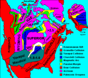
(between 4.5-billion and 540-million years ago) magma
forcing its way to the surface created the intrusive granite
s of the Canadian Shield
. These ancient granites can be seen on the North Shore today. It was during the Penokean orogeny
, part of the process that created the Great Lakes Tectonic Zone
, that many valuable metals were deposited. The region surrounding the lake has proved to be rich in mineral
s. Copper
, iron
, silver
, gold
and nickel
are or were the most frequently mined
. Examples include the Hemlo
gold mine near Marathon
, copper at Point Mamainse, silver at Silver Islet and uranium
at Theano Point.
The mountains steadily eroded, depositing layers of sediment
s which compacted and became limestone
, dolostone
, taconite
and the shale
at Kakabeka Falls
.
The continent was later riven
, creating one of the deepest rifts in the world. The lake lies in this long-extinct Mesoproterozoic
rift valley
, the Midcontinent Rift
. Magma was injected between layers of sedimentary rock, forming diabase
sills
. This hard diabase protects the layers of sedimentary rock below, forming the flat-topped mesas in the Thunder Bay
area.
Amethyst
formed in some of the cavities created by the Midcontinent Rift and there are several amethyst mines in the Thunder Bay area.
Lava
erupted from the rift and formed the black basalt
rock of Michipicoten Island, Black Bay Peninsula, and St. Ignace Island.
During the Wisconsin glaciation
10,000 years ago, ice covered the region at a thickness of 1.25 miles (2.01 km). The land contours familiar today were carved by the advance and retreat of the ice sheet
. The retreat left gravel, sand, clay and boulder deposits. Glacial meltwaters gathered in the Superior basin creating Lake Minong
, a precursor to Lake Superior. Without the immense weight of the ice, the land rebounded, and a drainage outlet formed at Sault Ste. Marie, which would become known as St. Mary's River.
 The first people came to the Lake Superior region 10,000 years ago after the retreat of the glaciers in the last Ice Age
. They are known as the Plano, and they used stone-tipped spears to hunt caribou on the northwestern side of Lake Minong.
The next documented people were known as the Shield Archaic (c. 5000-500 BC). Evidence of this culture can be found at the eastern and western ends of the Canadian shore. They used bows and arrows, dugout canoes, fished, hunted, mined copper for tools and weapons, and established trading networks. They are believed to be the direct ancestors of the Ojibwe and Cree
.
The Laurel people (c. 500 BC to AD 500) developed seine net fishing, evidence being found at rivers around Superior such as the Pic and Michipicoten.
Another culture known as the Terminal Woodland Indians (c. AD 900-1650) has been found. They were Algonkian
people who hunted, fished and gathered berries. They used snow shoes
, birch bark
canoes and conical or domed lodges. At the mouth of the Michipicoten River, nine layers of encampments have been discovered. Most of the Pukaskwa Pit
s were likely made during this time.
The Anishinaabe
, also known as the Ojibwe or Chippewa, have inhabited the Lake Superior region for over five hundred years and were preceded by the Dakota, Fox, Menominee
, Nipigon, Noquet and Gros Ventres
. They called Lake Superior Anishnaabe Gichgamiing, or "the Ojibwe's Ocean". After the arrival of Europeans, the Anishinaabe made themselves the middle-men between the French fur trade
rs and other Native peoples. They soon became the dominant Indian nation in the region: they forced out the Sioux
and Fox and won a victory against the Iroquois
west of Sault Ste. Marie in 1662. By the mid-18th century, the Ojibwe occupied all of Lake Superior's shores.
 In the 18th century, the fur trade in the region was booming, with the Hudson's Bay Company
having a virtual monopoly. In 1783, however, the North West Company
was formed to rival Hudson's Bay Company. The North West Company built forts on Lake Superior at Grand Portage, Nipigon, the Pic River, the Michipicoten River, and Sault Ste. Marie. But by 1821, with competition taking too great a toll on both, the companies merged under the Hudson's Bay Company name.
Many towns around the lake are either current or former mining
areas, or engaged in processing or shipping
. Today, tourism
is another significant industry
; the sparsely-populated Lake Superior country, with its rugged shorelines and wilderness
, attracts tourists and adventurers.
, providing a route for the transportation of iron ore
and other mined and manufactured materials. Large cargo vessels called lake freighter
s, as well as smaller ocean-going freighters
, transport these commodities across Lake Superior.
, and Whitefish Point is known as the "Graveyard of the Great Lakes" and more ships have been lost around the Whitefish Point area than any other part of Lake Superior. These shipwrecks are now protected by the Whitefish Point Underwater Preserve
. The SS Edmund Fitzgerald
was the last major shipwreck on Lake Superior, sinking 17 miles (27.4 km) from Whitefish Point on November 10, 1975.
According to legend, "Lake Superior seldom gives up her dead".
This is because of the unusually low temperature of the water, estimated at under 36 °F (2.2 °C) on average around 1970. Normally bacteria feeding on a sunken decaying body will generate gas inside the body, causing it to float to the surface after a few days. The water in Lake Superior is cold enough year-round to inhibit bacterial growth
, and bodies tend to sink and never surface. This is alluded to in Gordon Lightfoot
's ballad, "The Wreck of the Edmund Fitzgerald
". The Edmund Fitzgerald's 29 crew members all perished. Edmund Fitzgerald
adventurer Joe MacInnis reported that in July 1994, explorer Frederick Shannon's Expedition 94 to the Fitzgerald discovered and filmed a man's body near the port side of her pilothouse, not far from the open door, "fully clothed, wearing an orange life jacket, and lying face down in the sediment." No crew members were ever recovered. The Fitzgerald was swallowed up so intensely by Lake Superior that the 729 feet (222.2 m) ship split in half. Her two pieces are sitting approximately 170 feet (51.8 m) apart in a depth of 550 feet (167.6 m).
Storms that claimed multiple ships include the Mataafa Storm
on November 28, 1905, and the Great Lakes Storm of 1913
.
In August 2007 wreckage was found of the Cyprus, a 420 feet (128 m) ore carrier which sank during a Lake Superior storm in 460 feet (140.2 m) of water. All but Charles G. Pitz of the Cyprus’ 23 crew perished on October 11, 1907. The ore carrier sank in Lake Superior on her second voyage, while hauling iron ore from Superior, Wisconsin
, to Buffalo, New York
. Built in Lorain, Ohio
, the Cyprus was launched August 17, 1907.
In 1918 the last warships ever to sink in the great lakes, Inkerman and Cerisoles Minesweepers
vanished in a Lake Superior storm marking the largest loss of life on Lake Superior to date.
 Over 80 species of fish have been found in Lake Superior. Species native to the lake include: bloater
, brook trout
, burbot
, cisco, lake sturgeon
, lake trout
, lake whitefish
, longnose sucker
, muskellunge
, northern pike
, pumpkinseed
, rock bass
, round whitefish
, smallmouth bass
, walleye
, white sucker
and yellow perch
. In addition, many fish species have been either intentionally or accidentally introduced to Lake Superior: atlantic salmon
, brown trout
, carp
, chinook salmon
, coho salmon
, freshwater drum
, pink salmon
, rainbow smelt
, rainbow trout
, round goby
, ruffe
, sea lamprey
and white perch
.
Lake Superior has fewer dissolved nutrients relative to its water volume compared to the other Great Lakes and so is less productive in terms of fish populations and is an oligotrophic lake. This is a result of the underdeveloped soils found in its relatively small watershed. However, nitrate
concentrations in the lake have been continuously rising for more than a century. They are still much lower than levels considered dangerous to human health; but this steady, long-term rise is an unusual record of environmental nitrogen buildup. It may relate to anthropogenic alternations to the regional Nitrogen Cycle
, but researchers are still unsure of the causes of this change to the lake's ecology.
As for other Great Lakes fish populations have also been impacted by the accidental or intentional introduction of foreign species such as the sea lamprey
and Eurasian ruffe
. Accidental introductions have occurred in part by the removal of natural barriers to navigation between the Great Lakes. Overfishing has also been a factor in the decline of fish populations.
Shipwrecks
Great Lakes
The Great Lakes are a collection of freshwater lakes located in northeastern North America, on the Canada – United States border. Consisting of Lakes Superior, Michigan, Huron, Erie, and Ontario, they form the largest group of freshwater lakes on Earth by total surface, coming in second by volume...
of North America
North America
North America is a continent wholly within the Northern Hemisphere and almost wholly within the Western Hemisphere. It is also considered a northern subcontinent of the Americas...
. It is bounded to the north by the Canadian province of Ontario
Ontario
Ontario is a province of Canada, located in east-central Canada. It is Canada's most populous province and second largest in total area. It is home to the nation's most populous city, Toronto, and the nation's capital, Ottawa....
and the U.S. state
U.S. state
A U.S. state is any one of the 50 federated states of the United States of America that share sovereignty with the federal government. Because of this shared sovereignty, an American is a citizen both of the federal entity and of his or her state of domicile. Four states use the official title of...
of Minnesota
Minnesota
Minnesota is a U.S. state located in the Midwestern United States. The twelfth largest state of the U.S., it is the twenty-first most populous, with 5.3 million residents. Minnesota was carved out of the eastern half of the Minnesota Territory and admitted to the Union as the thirty-second state...
, and to the south by the U.S. states of Wisconsin
Wisconsin
Wisconsin is a U.S. state located in the north-central United States and is part of the Midwest. It is bordered by Minnesota to the west, Iowa to the southwest, Illinois to the south, Lake Michigan to the east, Michigan to the northeast, and Lake Superior to the north. Wisconsin's capital is...
and Michigan
Michigan
Michigan is a U.S. state located in the Great Lakes Region of the United States of America. The name Michigan is the French form of the Ojibwa word mishigamaa, meaning "large water" or "large lake"....
. It is the largest freshwater lake in the world by surface area if Lake Huron and Lake Michigan are considered to be two lakes. It is the world's third-largest freshwater lake by volume.
Name
The Ojibwe call the lake Gichigami, meaning "big water." Henry Wadsworth LongfellowHenry Wadsworth Longfellow
Henry Wadsworth Longfellow was an American poet and educator whose works include "Paul Revere's Ride", The Song of Hiawatha, and Evangeline...
wrote the name as "Gitche Gumee" in The Song of Hiawatha
The Song of Hiawatha
The Song of Hiawatha is an 1855 epic poem, in trochaic tetrameter, by Henry Wadsworth Longfellow, featuring an Indian hero and loosely based on legends and ethnography of the Ojibwe and other Native American peoples contained in Algic Researches and additional writings of Henry Rowe Schoolcraft...
, as did Gordon Lightfoot
Gordon Lightfoot
Gordon Meredith Lightfoot, Jr. is a Canadian singer-songwriter who achieved international success in folk, folk-rock, and country music, and has been credited for helping define the folk-pop sound of the 1960s and 1970s...
in his song, "The Wreck of the Edmund Fitzgerald
The Wreck of the Edmund Fitzgerald
"The Wreck of the Edmund Fitzgerald" is a song written, composed and performed by Canadian Gordon Lightfoot to commemorate the sinking of the bulk carrier SS Edmund Fitzgerald on Lake Superior on November 10, 1975. It was inspired by the Newsweek article on the event, "The Cruelest Month", which...
". The first French
French people
The French are a nation that share a common French culture and speak the French language as a mother tongue. Historically, the French population are descended from peoples of Celtic, Latin and Germanic origin, and are today a mixture of several ethnic groups...
explorers approaching the great inland sea by way of the Ottawa River and Lake Huron during the 17th century referred to their discovery as le lac superieur. Properly translated, the expression means "Upper Lake," that is, the lake above Lake Huron. The lake was also called Lac Tracy by 17th century Jesuit missionaries. The English, upon taking control of the region from the French in the 1760's, following the French and Indian War
French and Indian War
The French and Indian War is the common American name for the war between Great Britain and France in North America from 1754 to 1763. In 1756, the war erupted into the world-wide conflict known as the Seven Years' War and thus came to be regarded as the North American theater of that war...
, anglicized the lake's name to Superior, "on account of its being superior in magnitude to any of the lakes on that vast continent."
Hydrography
Lake Superior empties into Lake HuronLake Huron
Lake Huron is one of the five Great Lakes of North America. Hydrologically, it comprises the larger portion of Lake Michigan-Huron. It is bounded on the east by the Canadian province of Ontario and on the west by the state of Michigan in the United States...
via the St. Marys River
St. Marys River (Michigan-Ontario)
The St. Marys River , sometimes written as the St. Mary's River, drains Lake Superior, starting at the end of Whitefish Bay and flowing 74.5 miles southeast into Lake Huron, with a fall of ....
and the Soo Locks
Soo Locks
The Soo Locks are a set of parallel locks which enable ships to travel between Lake Superior and the lower Great Lakes. They are located on the St. Marys River between Lake Superior and Lake Huron, between the Upper Peninsula of the US state of Michigan and the Canadian province of Ontario...
. Lake Superior is the largest freshwater lake in the world based on surface area (if Lakes Michigan
Lake Michigan
Lake Michigan is one of the five Great Lakes of North America and the only one located entirely within the United States. It is the second largest of the Great Lakes by volume and the third largest by surface area, after Lake Superior and Lake Huron...
and Huron
Lake Huron
Lake Huron is one of the five Great Lakes of North America. Hydrologically, it comprises the larger portion of Lake Michigan-Huron. It is bounded on the east by the Canadian province of Ontario and on the west by the state of Michigan in the United States...
are taken separately (but, see Lake Michigan-Huron
Lake Michigan-Huron
Lake Michigan-Huron is geologically the largest of the North American Great Lakes. Traditionally considered to be two separate lakes, Lake Michigan and Lake Huron, it is hydrologically a single body of water connected at the Straits of Mackinac....
)), and the third largest in volume, behind Lake Baikal
Lake Baikal
Lake Baikal is the world's oldest at 30 million years old and deepest lake with an average depth of 744.4 metres.Located in the south of the Russian region of Siberia, between Irkutsk Oblast to the northwest and the Buryat Republic to the southeast, it is the most voluminous freshwater lake in the...
in Russia
Russia
Russia or , officially known as both Russia and the Russian Federation , is a country in northern Eurasia. It is a federal semi-presidential republic, comprising 83 federal subjects...
and Lake Tanganyika
Lake Tanganyika
Lake Tanganyika is an African Great Lake. It is estimated to be the second largest freshwater lake in the world by volume, and the second deepest, after Lake Baikal in Siberia; it is also the world's longest freshwater lake...
in Africa
Africa
Africa is the world's second largest and second most populous continent, after Asia. At about 30.2 million km² including adjacent islands, it covers 6% of the Earth's total surface area and 20.4% of the total land area...
. The Caspian Sea
Caspian Sea
The Caspian Sea is the largest enclosed body of water on Earth by area, variously classed as the world's largest lake or a full-fledged sea. The sea has a surface area of and a volume of...
, while larger than Lake Superior in both surface area and volume, is brackish; though presently isolated, historically the Caspian has been repeatedly connected to and isolated from the Mediterranean via the Black Sea
Black Sea
The Black Sea is bounded by Europe, Anatolia and the Caucasus and is ultimately connected to the Atlantic Ocean via the Mediterranean and the Aegean seas and various straits. The Bosphorus strait connects it to the Sea of Marmara, and the strait of the Dardanelles connects that sea to the Aegean...
.
Lake Superior has a surface area of 31700 square miles (82,103 km²), which is approximately the size of South Carolina
South Carolina
South Carolina is a state in the Deep South of the United States that borders Georgia to the south, North Carolina to the north, and the Atlantic Ocean to the east. Originally part of the Province of Carolina, the Province of South Carolina was one of the 13 colonies that declared independence...
. It has a maximum length of 350 smi and maximum breadth of 160 smi. Its average depth is 80.5 fathom (483 ft; 147 m) with a maximum depth of 222 fathom (1,332 ft; 406 m). Lake Superior contains 2,900 cubic miles (12,100 km³) of water. There is enough water in Lake Superior to cover the entire land mass
Landmass
A landmass is a contiguous area of land surrounded by ocean. Although it may be most often written as one word to distinguish it from the usage "land mass"—the measure of land area—it is also used as two words.Landmasses include:*supercontinents...
of North
North America
North America is a continent wholly within the Northern Hemisphere and almost wholly within the Western Hemisphere. It is also considered a northern subcontinent of the Americas...
and South America
South America
South America is a continent situated in the Western Hemisphere, mostly in the Southern Hemisphere, with a relatively small portion in the Northern Hemisphere. The continent is also considered a subcontinent of the Americas. It is bordered on the west by the Pacific Ocean and on the north and east...
with 1 feet (30.5 cm) of water. The shoreline of the lake stretches 2726 miles (4,387 km) (including islands).
American limnologist
Limnology
Limnology , also called freshwater science, is the study of inland waters. It is often regarded as a division of ecology or environmental science. It covers the biological, chemical, physical, geological, and other attributes of all inland waters...
J. Val Klump
J. Val Klump
Jeffrey Val Klump is an American limnologist. He was the first person to reach the deepest spot in Lake Superior, a depth of 1333 feet , which is also the lowest point in the United States, on July 30, 1985 while aboard the R/V Seward Johnson with the Johnson-SeaLink-II submersible...
was the first person to reach the lowest depth of Lake Superior on July 30, 1985, as part of a scientific expedition, which, at 733 feet (223.4 m) below sea level, is the lowest spot on the continental interior of the United States
United States
The United States of America is a federal constitutional republic comprising fifty states and a federal district...
and the second-lowest spot on the interior of the North America
North America
North America is a continent wholly within the Northern Hemisphere and almost wholly within the Western Hemisphere. It is also considered a northern subcontinent of the Americas...
n continent after the deeper Great Slave Lake
Great Slave Lake
Great Slave Lake is the second-largest lake in the Northwest Territories of Canada , the deepest lake in North America at , and the ninth-largest lake in the world. It is long and wide. It covers an area of in the southern part of the territory. Its given volume ranges from to and up to ...
in Canada
Canada
Canada is a North American country consisting of ten provinces and three territories. Located in the northern part of the continent, it extends from the Atlantic Ocean in the east to the Pacific Ocean in the west, and northward into the Arctic Ocean...
(1503 feet (458.1 m) below sea level). (Though Crater Lake
Crater Lake
Crater Lake is a caldera lake located in the south-central region of the U.S. state of Oregon. It is the main feature of Crater Lake National Park and famous for its deep blue color and water clarity. The lake partly fills a nearly deep caldera that was formed around 7,700 years agoby the...
, not Lake Superior, is the deepest lake in the United States, Crater Lake's surface elevation is much higher and its deepest point is 4229 feet (1,289 m) above sea level.)
While the temperature of the surface of the lake varies seasonally, the temperature below 660 feet (201.2 m) is an almost constant 39°F (4°C). This variation in temperature makes the lake seasonally stratigraphic
Stratification (water)
Water stratification occurs when water masses with different properties - salinity , oxygenation , density , temperature - form layers that act as barriers to water mixing...
. Twice per year, however, the water column reaches a uniform temperature of 39°F (4°C) from top to bottom, and the lake waters are able to completely mix. This feature makes the lake dimictic. Because of its size Superior has a retention time
Lake retention time
Lake retention time is a calculated quantity expressing the mean time that water spends in a particular lake. At its simplest this figure is the result of dividing the lake volume by the flow in or out of the lake...
of 191 years.
Annual storms on Lake Superior regularly record wave heights of over 20 feet (6 m). Waves well over 30 feet (9 m) have been recorded.
Tributaries and outlet
The lake is fed by over 200 rivers. The largest include the Nipigon RiverNipigon River
The Nipigon River is about long and 50 to 200 m wide in Ontario, Canada. The river drains Lake Nipigon into Nipigon Bay in Lake Superior, dropping from an elevation of 260 m to 183 m .-History:...
, the St. Louis River
Saint Louis River
The St. Louis River is a river in the U.S. states of Minnesota and Wisconsin that flows into Lake Superior. The largest U.S. river to flow into the lake, it is 179 miles in length and starts near Hoyt Lakes, Minnesota. The river's watershed is in area...
, the Pigeon River
Pigeon River (Minnesota-Ontario)
The Pigeon River forms part of the US-Canada border between the State of Minnesota and the Province of Ontario west of Lake Superior. In pre-industrial times the river was a waterway of great importance for transportation and trade.-Geography:...
, the Pic River
Pic River
The Pic River is a river in the east part of Thunder Bay District in northwestern Ontario, Canada. It flows from McKay Lake southeast of the community of Longlac and empties into Lake Superior southeast of the town of Marathon.-Course:...
, the White River
White River (Ontario)
White River is a river in Ontario Province, Canada. It is one of many tributaries that feeds Lake Superior.-Sources:...
, the Michipicoten River
Michipicoten River
The Michipicoten River is a river in the Algoma District of northern Ontario, Canada, which flows from Dog Lake and joins with the Magpie River to empty into Michipicoten Bay on Lake Superior near the town of Wawa...
, the Bois Brule River
Bois Brule River
The Bois Brule River is a river situated in Douglas County, Wisconsin, near its eastern border with Bayfield County. The river, which is 44 miles long, rises in central Douglas County near Upper St...
and the Kaministiquia River
Kaministiquia River
The Kaministiquia River is a river which empties into western Lake Superior at the city of Thunder Bay, Ontario. Kaministiquia is an Ojibwe word meaning " with islands" due to two large islands at the mouth of the river...
. Lake Superior drains into Lake Huron
Lake Huron
Lake Huron is one of the five Great Lakes of North America. Hydrologically, it comprises the larger portion of Lake Michigan-Huron. It is bounded on the east by the Canadian province of Ontario and on the west by the state of Michigan in the United States...
by the St. Marys River. The rapids on the river necessitate the Sault Locks
Soo Locks
The Soo Locks are a set of parallel locks which enable ships to travel between Lake Superior and the lower Great Lakes. They are located on the St. Marys River between Lake Superior and Lake Huron, between the Upper Peninsula of the US state of Michigan and the Canadian province of Ontario...
, a part of the Great Lakes Waterway
Great Lakes Waterway
The Great Lakes Waterway is a system of channels and canals that makes all of the Great Lakes accessible to oceangoing vessels. Its principal civil engineering components are the Welland Canal, bypassing Niagara Falls between Lake Ontario and Lake Erie, and the Soo Locks, bypassing the rapids of...
, to move boats over the 25 feet (8 m) height difference from Lake Huron.
Water levels
Above mean sea level
The term above mean sea level refers to the elevation or altitude of any object, relative to the average sea level datum. AMSL is used extensively in radio by engineers to determine the coverage area a station will be able to reach...
. Until approximately 1887 the natural hydraulic conveyance through the St. Marys River
St. Marys River (Michigan-Ontario)
The St. Marys River , sometimes written as the St. Mary's River, drains Lake Superior, starting at the end of Whitefish Bay and flowing 74.5 miles southeast into Lake Huron, with a fall of ....
rapids determined outflow from Lake Superior. By 1921 development in support of transportation and hydropower resulted in gates, locks, power canals and other control structures completely spanning St. Marys rapids. The regulating structure is known as the Compensating Works and is operated according to a regulation plan known as Plan 1977-A. The current water levels, including diversions of water from the Hudson Bay
Hudson Bay
Hudson Bay , sometimes called Hudson's Bay, is a large body of saltwater in northeastern Canada. It drains a very large area, about , that includes parts of Ontario, Quebec, Saskatchewan, Alberta, most of Manitoba, southeastern Nunavut, as well as parts of North Dakota, South Dakota, Minnesota,...
watershed, are governed by the International Lake Superior Board of Control which was established in 1914 by the International Joint Commission
International Joint Commission
The International Joint Commission is an independent binational organization established by the United States and Canada under the Boundary Waters Treaty of 1909.The Commission has responsibilities related to the following treaties and agreements:...
.
Superior's water levels temporarily reached a new low in September 2007, slightly less than the previous record low in 1926. However, the water levels returned within a few days.
Historic High Water
The lake fluctuates from month to month with the highest lake levels in October and November. The normal highwater mark is 1.17 foot (0.356616 m) above datum (601.1 ft or 183.2 m). In the summer of 1985, Lake Superior reached its highest level at 2.33 foot (0.710184 m) above datum. The winter of 1986 set new highwater records through the winter and spring months (January - June), ranging from 1.33 foot (0.405384 m) to 1.833 foot (0.5586984 m) above Chart Datum.
Historic Low Water
The lake fluctuates from month to month with the lowest lake levels in March and April. The normal lowwater mark is 0.33 foot (0.100584 m) below datum (601.1 ft or 183.2 m). In the winter of 1926 Lake Superior reached its lowest level at 1.58 foot (0.481584 m) below datum. Additionally, the entire first half of the year (January - June) saw record low months. The low water was a continuation of the dropping lake levels from the previous year, 1925; which set lowwater records for October through December. During this nine-month period (Oct 1925-June 1926) water levels ranged from 1.58 foot (0.481584 m) to 0.33 foot (0.100584 m) below Chart Datum. In the summer of 2007 monthly historic lows were set; August at 0.66 foot (0.201168 m), September at 0.58 foot (0.176784 m).
Climate change
According to a study by professors at the University of Minnesota DuluthUniversity of Minnesota Duluth
The University of Minnesota Duluth is a regional branch of the University of Minnesota system located in Duluth, Minnesota, USA. As Duluth's public research university, UMD offers 13 bachelor's degrees in 74 majors, graduate programs in 24 different fields, a two-year program at the School of...
, Lake Superior may have warmed faster than its surrounding climate. Summer surface temperatures in the lake appeared to have increased by about 4.5 °F (2.5 °C) since 1979, compared with an approximately 2.7 °F (1.5 °C) increase in the surrounding average air temperature. The increase in the lake’s surface temperature may be related to the decreasing ice cover. Less winter ice cover allows more solar radiation to penetrate the lake and warm the water. If trends continue Lake Superior, which freezes over completely once every 20 years, could routinely be ice-free by 2040. These warmer temperatures can actually lead to more snow in the lake effect snow belts along the shores of the lake, especially in the Upper Peninsula of Michigan
Upper Peninsula of Michigan
The Upper Peninsula of Michigan is the northern of the two major land masses that make up the U.S. state of Michigan. It is commonly referred to as the Upper Peninsula, the U.P., or Upper Michigan. It is also known as the land "above the Bridge" linking the two peninsulas. The peninsula is bounded...
.
Geography
The largest island in Lake Superior is Isle RoyaleIsle Royale
Isle Royale is an island of the Great Lakes, located in the northwest of Lake Superior, and part of the state of Michigan. The island and the 450 surrounding smaller islands and waters make up Isle Royale National Park....
in the state of Michigan
Michigan
Michigan is a U.S. state located in the Great Lakes Region of the United States of America. The name Michigan is the French form of the Ojibwa word mishigamaa, meaning "large water" or "large lake"....
. Isle Royale contains several lakes, some of which also contain islands. Other large famous islands include Madeline Island
Madeline Island
Madeline Island is an island of the U.S. state of Wisconsin located in Lake Superior approximately two miles northeast of Bayfield, Wisconsin, and connected to that town seasonally by a 20 minute ferry ride or an ice road. It is the largest of the Apostle Islands, although it is not included...
in the state of Wisconsin
Wisconsin
Wisconsin is a U.S. state located in the north-central United States and is part of the Midwest. It is bordered by Minnesota to the west, Iowa to the southwest, Illinois to the south, Lake Michigan to the east, Michigan to the northeast, and Lake Superior to the north. Wisconsin's capital is...
, Michipicoten Island
Michipicoten Island
Michipicoten Island is an island in Ontario, Canada, in the northeastern part of Lake Superior, approximately 175 km northwest of Sault Ste. Marie and 65 km southwest of Wawa, Ontario...
in the province of Ontario
Ontario
Ontario is a province of Canada, located in east-central Canada. It is Canada's most populous province and second largest in total area. It is home to the nation's most populous city, Toronto, and the nation's capital, Ottawa....
, and Grand Island (location of the Grand Island National Recreation Area
Grand Island National Recreation Area
The Grand Island National Recreation Area is a National Recreation Area within the jurisdiction of the U.S. Forest Service. It is part of the Hiawatha National Forest. Located on Grand Island, Michigan offshore from Munising, Michigan, the Grand Island National Recreation Area covers approximately ...
) in the state of Michigan
Michigan
Michigan is a U.S. state located in the Great Lakes Region of the United States of America. The name Michigan is the French form of the Ojibwa word mishigamaa, meaning "large water" or "large lake"....
.
The larger cities on Lake Superior include: the twin ports of Duluth, Minnesota
Duluth, Minnesota
Duluth is a port city in the U.S. state of Minnesota and is the county seat of Saint Louis County. The fourth largest city in Minnesota, Duluth had a total population of 86,265 in the 2010 census. Duluth is also the second largest city that is located on Lake Superior after Thunder Bay, Ontario,...
, and Superior, Wisconsin
Superior, Wisconsin
Superior is a city in and the county seat of Douglas County, Wisconsin, United States. The population was 26,960 at the 2010 census. Located at the junction of U.S. Highways 2 and 53, it is north of and adjacent to both the Village of Superior and the Town of Superior.Superior is at the western...
; Thunder Bay
Thunder Bay
-In Canada:Thunder Bay is the name of three places in the province of Ontario, Canada along Lake Superior:*Thunder Bay District, Ontario, a district in Northwestern Ontario*Thunder Bay, a city in Thunder Bay District*Thunder Bay, Unorganized, Ontario...
, Ontario
Ontario
Ontario is a province of Canada, located in east-central Canada. It is Canada's most populous province and second largest in total area. It is home to the nation's most populous city, Toronto, and the nation's capital, Ottawa....
; Marquette, Michigan
Marquette, Michigan
Marquette is a city in the U.S. state of Michigan and the county seat of Marquette County. The population was 21,355 at the 2010 census, making it the most populated city of the Upper Peninsula. Marquette is a major port on Lake Superior, primarily for shipping iron ore and is the home of Northern...
; and the twin cities of Sault Ste. Marie, Michigan
Sault Ste. Marie, Michigan
Sault Ste. Marie is a city in and the county seat of Chippewa County in the U.S. state of Michigan. It is in the north-eastern end of Michigan's Upper Peninsula, on the Canadian border, separated from its twin city of Sault Ste. Marie, Ontario, by the St. Marys River...
, and Sault Ste. Marie, Ontario
Sault Ste. Marie, Ontario
Sault Ste. Marie is a city on the St. Marys River in Algoma District, Ontario, Canada. It is the third largest city in Northern Ontario, after Sudbury and Thunder Bay, with a population of 74,948. The community was founded as a French religious mission: Sault either means "jump" or "rapids" in...
. Duluth, at the western tip of Lake Superior, is the most inland point on the St. Lawrence Seaway and the most inland port in the world.
Among the scenic places on the lake are: the Apostle Islands National Lakeshore
Apostle Islands National Lakeshore
The Apostle Islands National Lakeshore is a U.S. national lakeshore consisting of 21 islands and shoreline encompassing 69,372 acres on the northern tip of Wisconsin on the shore of Lake Superior....
, Isle Royale National Park
Isle Royale National Park
Isle Royale National Park is a U.S. National Park in the state of Michigan. Isle Royale, the largest island in Lake Superior, is over 45 miles in length and 9 miles wide at its widest point. The park is made of Isle Royale itself and approximately 400 smaller islands, along with any submerged...
, Porcupine Mountains Wilderness State Park, Pukaskwa National Park
Pukaskwa National Park
Pukaskwa National Park is a national park located south of the town of Marathon, Ontario in the Thunder Bay District of northern Ontario, Canada. Established in 1978, Pukaskwa is known for its vistas of Lake Superior and boreal forests...
, Lake Superior Provincial Park
Lake Superior Provincial Park
Lake Superior Provincial Park is one of the largest provincial parks in Ontario, covering about along the northeastern shores of Lake Superior between Wawa and Sault Ste. Marie in Algoma District, Northeastern Ontario, Canada...
, Grand Island National Recreation Area
Grand Island National Recreation Area
The Grand Island National Recreation Area is a National Recreation Area within the jurisdiction of the U.S. Forest Service. It is part of the Hiawatha National Forest. Located on Grand Island, Michigan offshore from Munising, Michigan, the Grand Island National Recreation Area covers approximately ...
, Sleeping Giant (Ontario)
Sleeping Giant (Ontario)
The Sleeping Giant is a formation of mesas and sills on Sibley Peninsula which resembles a giant lying on its back when viewed from the West to North-Northwest section of Thunder Bay, Ontario, Canada. As one moves southward along the shoreline toward Squaw Bay the Sleeping Giant starts to separate...
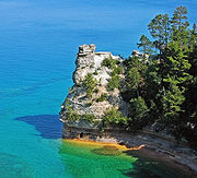
and Pictured Rocks National Lakeshore
Pictured Rocks National Lakeshore
Pictured Rocks National Lakeshore is a U.S. National Lakeshore on the shore of Lake Superior in the Upper Peninsula of Michigan, United States. It extends for 42 miles along the shore and covers...
.
Great Lakes Circle Tour
The Great Lakes Circle TourGreat Lakes Circle Tour
The Great Lakes Circle Tour is a designated scenic road system connecting all of the Great Lakes and the St. Lawrence River. It consists of routes for circumnavigating the lakes, either individually or collectively.-Lake Superior Circle Tour:...
is a designated scenic road system connecting all of the Great Lakes and the St. Lawrence River.
Climate
Lake Superior's size creates a localized oceanicOceanic climate
An oceanic climate, also called marine west coast climate, maritime climate, Cascadian climate and British climate for Köppen climate classification Cfb and subtropical highland for Köppen Cfb or Cwb, is a type of climate typically found along the west coasts at the middle latitudes of some of the...
or maritime climate (more typically seen in locations like Nova Scotia
Nova Scotia
Nova Scotia is one of Canada's three Maritime provinces and is the most populous province in Atlantic Canada. The name of the province is Latin for "New Scotland," but "Nova Scotia" is the recognized, English-language name of the province. The provincial capital is Halifax. Nova Scotia is the...
). The water surface's slow reaction to temperature changes, seasonally ranging between 32 and 55 °F (0-13 °C) around 1970, helps to moderate surrounding air temperatures in the summer and winter, and creates lake effect snow
Lake effect snow
Lake-effect snow is produced during cooler atmospheric conditions when cold winds move across long expanses of warmer lake water, providing energy and picking up water vapor which freezes and is deposited on the leeward shores...
in colder months. The hills and mountain
Mountain
Image:Himalaya_annotated.jpg|thumb|right|The Himalayan mountain range with Mount Everestrect 58 14 160 49 Chomo Lonzorect 200 28 335 52 Makalurect 378 24 566 45 Mount Everestrect 188 581 920 656 Tibetan Plateaurect 250 406 340 427 Rong River...
s that border the lake hold moisture and fog, particularly in the fall.
The lake's surface temperature has risen by 4.5 °F (2.5 °C) since 1979.
Geology
The rocks of Lake Superior's northern shore date back to the early history of the earth. During the PrecambrianPrecambrian
The Precambrian is the name which describes the large span of time in Earth's history before the current Phanerozoic Eon, and is a Supereon divided into several eons of the geologic time scale...
(between 4.5-billion and 540-million years ago) magma
Magma
Magma is a mixture of molten rock, volatiles and solids that is found beneath the surface of the Earth, and is expected to exist on other terrestrial planets. Besides molten rock, magma may also contain suspended crystals and dissolved gas and sometimes also gas bubbles. Magma often collects in...
forcing its way to the surface created the intrusive granite
Granite
Granite is a common and widely occurring type of intrusive, felsic, igneous rock. Granite usually has a medium- to coarse-grained texture. Occasionally some individual crystals are larger than the groundmass, in which case the texture is known as porphyritic. A granitic rock with a porphyritic...
s of the Canadian Shield
Canadian Shield
The Canadian Shield, also called the Laurentian Plateau, or Bouclier Canadien , is a vast geological shield covered by a thin layer of soil that forms the nucleus of the North American or Laurentia craton. It is an area mostly composed of igneous rock which relates to its long volcanic history...
. These ancient granites can be seen on the North Shore today. It was during the Penokean orogeny
Penokean orogeny
The Penokean orogeny was a mountain-building episode that occurred in the early Proterozoic about 1.85 to 1.84 billion years ago, in the area of North America that would eventually become Minnesota, Wisconsin, Michigan and Ontario...
, part of the process that created the Great Lakes Tectonic Zone
Great Lakes tectonic zone
During the Late Archean Eon the Algoman orogeny added landmass to the Superior province by volcanic activity and continental collision along a boundary that stretches from present-day South Dakota, U.S., into the Sudbury, Ontario, Canada, Lake Huron region....
, that many valuable metals were deposited. The region surrounding the lake has proved to be rich in mineral
Mineral
A mineral is a naturally occurring solid chemical substance formed through biogeochemical processes, having characteristic chemical composition, highly ordered atomic structure, and specific physical properties. By comparison, a rock is an aggregate of minerals and/or mineraloids and does not...
s. Copper
Copper
Copper is a chemical element with the symbol Cu and atomic number 29. It is a ductile metal with very high thermal and electrical conductivity. Pure copper is soft and malleable; an exposed surface has a reddish-orange tarnish...
, iron
Iron
Iron is a chemical element with the symbol Fe and atomic number 26. It is a metal in the first transition series. It is the most common element forming the planet Earth as a whole, forming much of Earth's outer and inner core. It is the fourth most common element in the Earth's crust...
, silver
Silver
Silver is a metallic chemical element with the chemical symbol Ag and atomic number 47. A soft, white, lustrous transition metal, it has the highest electrical conductivity of any element and the highest thermal conductivity of any metal...
, gold
Gold
Gold is a chemical element with the symbol Au and an atomic number of 79. Gold is a dense, soft, shiny, malleable and ductile metal. Pure gold has a bright yellow color and luster traditionally considered attractive, which it maintains without oxidizing in air or water. Chemically, gold is a...
and nickel
Nickel
Nickel is a chemical element with the chemical symbol Ni and atomic number 28. It is a silvery-white lustrous metal with a slight golden tinge. Nickel belongs to the transition metals and is hard and ductile...
are or were the most frequently mined
Mining
Mining is the extraction of valuable minerals or other geological materials from the earth, from an ore body, vein or seam. The term also includes the removal of soil. Materials recovered by mining include base metals, precious metals, iron, uranium, coal, diamonds, limestone, oil shale, rock...
. Examples include the Hemlo
Golden Giant Mine
The Golden Giant Mine is an abandoned underground gold mine in the Hemlo mining camp in Canada, located north of Lake Superior, midway between Sault Ste...
gold mine near Marathon
Marathon, Ontario
Marathon is a town in the Canadian province of Ontario, located in Thunder Bay District, on the north shore of Lake Superior north of Pukaskwa National Park, in the heart of the Canadian Shield.- History :...
, copper at Point Mamainse, silver at Silver Islet and uranium
Uranium
Uranium is a silvery-white metallic chemical element in the actinide series of the periodic table, with atomic number 92. It is assigned the chemical symbol U. A uranium atom has 92 protons and 92 electrons, of which 6 are valence electrons...
at Theano Point.
The mountains steadily eroded, depositing layers of sediment
Sediment
Sediment is naturally occurring material that is broken down by processes of weathering and erosion, and is subsequently transported by the action of fluids such as wind, water, or ice, and/or by the force of gravity acting on the particle itself....
s which compacted and became limestone
Limestone
Limestone is a sedimentary rock composed largely of the minerals calcite and aragonite, which are different crystal forms of calcium carbonate . Many limestones are composed from skeletal fragments of marine organisms such as coral or foraminifera....
, dolostone
Dolostone
Dolostone or dolomite rock is a sedimentary carbonate rock that contains a high percentage of the mineral dolomite. In old U.S.G.S. publications it was referred to as magnesian limestone. Most dolostone formed as a magnesium replacement of limestone or lime mud prior to lithification. It is...
, taconite
Taconite
Taconite is a variety of iron formation, an iron-bearing sedimentary rock, in which the iron minerals are interlayered with quartz, chert, or carbonate...
and the shale
Shale
Shale is a fine-grained, clastic sedimentary rock composed of mud that is a mix of flakes of clay minerals and tiny fragments of other minerals, especially quartz and calcite. The ratio of clay to other minerals is variable. Shale is characterized by breaks along thin laminae or parallel layering...
at Kakabeka Falls
Kakabeka Falls
Kakabeka Falls Provincial Park, established in 1955, covers 5 km² and is managed by Ontario Parks. It surrounds the falls and extends along the Kaministiquia River, which was used centuries ago by Voyageurs, who were the first Europeans to overwinter annually in northern Ontario...
.
The continent was later riven
Rift
In geology, a rift or chasm is a place where the Earth's crust and lithosphere are being pulled apart and is an example of extensional tectonics....
, creating one of the deepest rifts in the world. The lake lies in this long-extinct Mesoproterozoic
Mesoproterozoic
The Mesoproterozoic Era is a geologic era that occurred between 1600 Ma and 1000 Ma . The Mesoproterozoic was the first period of Earth's history with a respectable geological record. Continents existed in the Paleoproterozoic, but we know little about them...
rift valley
Rift valley
A rift valley is a linear-shaped lowland between highlands or mountain ranges created by the action of a geologic rift or fault. This action is manifest as crustal extension, a spreading apart of the surface which is subsequently further deepened by the forces of erosion...
, the Midcontinent Rift
Midcontinent Rift System
The Midcontinent Rift System or Keweenawan Rift is a long geological rift in the center of the North American continent and south-central part of the North American plate. It formed when the continent's core, the North American craton, began to split apart during the Mesoproterozoic era of the...
. Magma was injected between layers of sedimentary rock, forming diabase
Diabase
Diabase or dolerite is a mafic, holocrystalline, subvolcanic rock equivalent to volcanic basalt or plutonic gabbro. In North American usage, the term diabase refers to the fresh rock, whilst elsewhere the term dolerite is used for the fresh rock and diabase refers to altered material...
sills
Sill (geology)
In geology, a sill is a tabular sheet intrusion that has intruded between older layers of sedimentary rock, beds of volcanic lava or tuff, or even along the direction of foliation in metamorphic rock. The term sill is synonymous with concordant intrusive sheet...
. This hard diabase protects the layers of sedimentary rock below, forming the flat-topped mesas in the Thunder Bay
Thunder Bay
-In Canada:Thunder Bay is the name of three places in the province of Ontario, Canada along Lake Superior:*Thunder Bay District, Ontario, a district in Northwestern Ontario*Thunder Bay, a city in Thunder Bay District*Thunder Bay, Unorganized, Ontario...
area.
Amethyst
Amethyst
Amethyst is a violet variety of quartz often used in jewelry. The name comes from the Ancient Greek ἀ a- and μέθυστος methustos , a reference to the belief that the stone protected its owner from drunkenness; the ancient Greeks and Romans wore amethyst and made drinking vessels of it in the belief...
formed in some of the cavities created by the Midcontinent Rift and there are several amethyst mines in the Thunder Bay area.
Lava
Lava
Lava refers both to molten rock expelled by a volcano during an eruption and the resulting rock after solidification and cooling. This molten rock is formed in the interior of some planets, including Earth, and some of their satellites. When first erupted from a volcanic vent, lava is a liquid at...
erupted from the rift and formed the black basalt
Basalt
Basalt is a common extrusive volcanic rock. It is usually grey to black and fine-grained due to rapid cooling of lava at the surface of a planet. It may be porphyritic containing larger crystals in a fine matrix, or vesicular, or frothy scoria. Unweathered basalt is black or grey...
rock of Michipicoten Island, Black Bay Peninsula, and St. Ignace Island.
During the Wisconsin glaciation
Wisconsin glaciation
The last glacial period was the most recent glacial period within the current ice age occurring during the last years of the Pleistocene, from approximately 110,000 to 10,000 years ago....
10,000 years ago, ice covered the region at a thickness of 1.25 miles (2.01 km). The land contours familiar today were carved by the advance and retreat of the ice sheet
Ice sheet
An ice sheet is a mass of glacier ice that covers surrounding terrain and is greater than 50,000 km² , thus also known as continental glacier...
. The retreat left gravel, sand, clay and boulder deposits. Glacial meltwaters gathered in the Superior basin creating Lake Minong
Glacial Lake Minong
Glacial Lake Minong was a proglacial lake that formed in the Lake Superior basin during the Wisconsin glaciation around 10,000 B.P. . This was the last glacial advance that entered Michigan and covered only part of the upper peninsula. Lake Minong occurred in the eastern corner of the Lake...
, a precursor to Lake Superior. Without the immense weight of the ice, the land rebounded, and a drainage outlet formed at Sault Ste. Marie, which would become known as St. Mary's River.
History
Ice age
An ice age or, more precisely, glacial age, is a generic geological period of long-term reduction in the temperature of the Earth's surface and atmosphere, resulting in the presence or expansion of continental ice sheets, polar ice sheets and alpine glaciers...
. They are known as the Plano, and they used stone-tipped spears to hunt caribou on the northwestern side of Lake Minong.
The next documented people were known as the Shield Archaic (c. 5000-500 BC). Evidence of this culture can be found at the eastern and western ends of the Canadian shore. They used bows and arrows, dugout canoes, fished, hunted, mined copper for tools and weapons, and established trading networks. They are believed to be the direct ancestors of the Ojibwe and Cree
Cree
The Cree are one of the largest groups of First Nations / Native Americans in North America, with 200,000 members living in Canada. In Canada, the major proportion of Cree live north and west of Lake Superior, in Ontario, Manitoba, Saskatchewan, Alberta and the Northwest Territories, although...
.
The Laurel people (c. 500 BC to AD 500) developed seine net fishing, evidence being found at rivers around Superior such as the Pic and Michipicoten.
Another culture known as the Terminal Woodland Indians (c. AD 900-1650) has been found. They were Algonkian
Algonquian peoples
The Algonquian are one of the most populous and widespread North American native language groups, with tribes originally numbering in the hundreds. Today hundreds of thousands of individuals identify with various Algonquian peoples...
people who hunted, fished and gathered berries. They used snow shoes
Snowshoe
A snowshoe is footwear for walking over the snow. Snowshoes work by distributing the weight of the person over a larger area so that the person's foot does not sink completely into the snow, a quality called "flotation"....
, birch bark
Birch bark
Birch bark or birchbark is the bark of several Eurasian and North American birch trees of the genus Betula.The strong and water-resistant cardboard-like bark can be easily cut, bent, and sewn, which made it a valuable building, crafting, and writing material, since pre-historic times...
canoes and conical or domed lodges. At the mouth of the Michipicoten River, nine layers of encampments have been discovered. Most of the Pukaskwa Pit
Pukaskwa Pit
Pukaskwa Pits are small holes dug in the ground by ancestors of the Ojibwa, named after the Pukaskwa River, near Lake Superior. Estimations of the dates of their digging range from between 1100 and 1600 CE on the near end, to 3,000 to 8,000 BCE on the far end....
s were likely made during this time.
The Anishinaabe
Anishinaabe
Anishinaabe or Anishinabe—or more properly Anishinaabeg or Anishinabek, which is the plural form of the word—is the autonym often used by the Odawa, Ojibwe, and Algonquin peoples. They all speak closely related Anishinaabemowin/Anishinaabe languages, of the Algonquian language family.The meaning...
, also known as the Ojibwe or Chippewa, have inhabited the Lake Superior region for over five hundred years and were preceded by the Dakota, Fox, Menominee
Menominee
Some placenames use other spellings, see also Menomonee and Menomonie.The Menominee are a nation of Native Americans living in Wisconsin. The Menominee, along with the Ho-Chunk, are the only tribes that are indigenous to what is now Wisconsin...
, Nipigon, Noquet and Gros Ventres
Gros Ventres
The Gros Ventre people , also known as the A'ani, A'aninin, Haaninin, and Atsina, are a historically Algonquian-speaking Native American tribe located in north central Montana...
. They called Lake Superior Anishnaabe Gichgamiing, or "the Ojibwe's Ocean". After the arrival of Europeans, the Anishinaabe made themselves the middle-men between the French fur trade
Fur trade
The fur trade is a worldwide industry dealing in the acquisition and sale of animal fur. Since the establishment of world market for in the early modern period furs of boreal, polar and cold temperate mammalian animals have been the most valued...
rs and other Native peoples. They soon became the dominant Indian nation in the region: they forced out the Sioux
Sioux
The Sioux are Native American and First Nations people in North America. The term can refer to any ethnic group within the Great Sioux Nation or any of the nation's many language dialects...
and Fox and won a victory against the Iroquois
Iroquois
The Iroquois , also known as the Haudenosaunee or the "People of the Longhouse", are an association of several tribes of indigenous people of North America...
west of Sault Ste. Marie in 1662. By the mid-18th century, the Ojibwe occupied all of Lake Superior's shores.
Hudson's Bay Company
The Hudson's Bay Company , abbreviated HBC, or "The Bay" is the oldest commercial corporation in North America and one of the oldest in the world. A fur trading business for much of its existence, today Hudson's Bay Company owns and operates retail stores throughout Canada...
having a virtual monopoly. In 1783, however, the North West Company
North West Company
The North West Company was a fur trading business headquartered in Montreal from 1779 to 1821. It competed with increasing success against the Hudson's Bay Company in what was to become Western Canada...
was formed to rival Hudson's Bay Company. The North West Company built forts on Lake Superior at Grand Portage, Nipigon, the Pic River, the Michipicoten River, and Sault Ste. Marie. But by 1821, with competition taking too great a toll on both, the companies merged under the Hudson's Bay Company name.
Many towns around the lake are either current or former mining
Mining
Mining is the extraction of valuable minerals or other geological materials from the earth, from an ore body, vein or seam. The term also includes the removal of soil. Materials recovered by mining include base metals, precious metals, iron, uranium, coal, diamonds, limestone, oil shale, rock...
areas, or engaged in processing or shipping
Shipping
Shipping has multiple meanings. It can be a physical process of transporting commodities and merchandise goods and cargo, by land, air, and sea. It also can describe the movement of objects by ship.Land or "ground" shipping can be by train or by truck...
. Today, tourism
Tourism
Tourism is travel for recreational, leisure or business purposes. The World Tourism Organization defines tourists as people "traveling to and staying in places outside their usual environment for not more than one consecutive year for leisure, business and other purposes".Tourism has become a...
is another significant industry
Industry
Industry refers to the production of an economic good or service within an economy.-Industrial sectors:There are four key industrial economic sectors: the primary sector, largely raw material extraction industries such as mining and farming; the secondary sector, involving refining, construction,...
; the sparsely-populated Lake Superior country, with its rugged shorelines and wilderness
Wilderness
Wilderness or wildland is a natural environment on Earth that has not been significantly modified by human activity. It may also be defined as: "The most intact, undisturbed wild natural areas left on our planet—those last truly wild places that humans do not control and have not developed with...
, attracts tourists and adventurers.
Shipping
Lake Superior has been an important link in the Great Lakes WaterwayGreat Lakes Waterway
The Great Lakes Waterway is a system of channels and canals that makes all of the Great Lakes accessible to oceangoing vessels. Its principal civil engineering components are the Welland Canal, bypassing Niagara Falls between Lake Ontario and Lake Erie, and the Soo Locks, bypassing the rapids of...
, providing a route for the transportation of iron ore
Taconite
Taconite is a variety of iron formation, an iron-bearing sedimentary rock, in which the iron minerals are interlayered with quartz, chert, or carbonate...
and other mined and manufactured materials. Large cargo vessels called lake freighter
Lake freighter
Lake freighters, or Lakers, are bulk carrier vessels that ply the Great Lakes. The best known was the , the most recent and largest major vessel to be wrecked on the Lakes. These vessels are traditionally called boats, although classified as ships. In the mid-20th century, 300 lakers worked the...
s, as well as smaller ocean-going freighters
Seawaymax
The term Seawaymax refers to vessels which are the maximum size that can fit through the canal locks of the St. Lawrence Seaway.Seawaymax vessels are in length, wide, and have a draft of and a height above the waterline of . A number of lake freighters larger than this size cruise the Great...
, transport these commodities across Lake Superior.
Shipwrecks
According to shipwreck historian Frederick Stonehouse, the southern shore of Lake Superior between Grand Marais, MichiganGrand Marais, Michigan
Grand Marais is an unincorporated community in Burt Township, Alger County in the U.S. state of Michigan. It is located on Lake Superior at and is the eastern gateway to the Pictured Rocks National Lakeshore via H-58....
, and Whitefish Point is known as the "Graveyard of the Great Lakes" and more ships have been lost around the Whitefish Point area than any other part of Lake Superior. These shipwrecks are now protected by the Whitefish Point Underwater Preserve
Whitefish Point Underwater Preserve
The Whitefish Point Underwater Preserve was established in 1987 to protect and conserve shipwrecks and historical resources on of Lake Superior bottomlands in Whitefish Bay and around Whitefish Point, Michigan. The formation of the Michigan Underwater Preserves helped stop controversy over...
. The SS Edmund Fitzgerald
SS Edmund Fitzgerald
The SS Edmund Fitzgerald was an American Great Lakes freighter that made headlines after sinking in a Lake Superior storm on November 10, 1975, with the loss of the entire crew of 29. When launched on June 8, 1958, she was the largest boat on North America's Great Lakes, and she remains...
was the last major shipwreck on Lake Superior, sinking 17 miles (27.4 km) from Whitefish Point on November 10, 1975.
According to legend, "Lake Superior seldom gives up her dead".
This is because of the unusually low temperature of the water, estimated at under 36 °F (2.2 °C) on average around 1970. Normally bacteria feeding on a sunken decaying body will generate gas inside the body, causing it to float to the surface after a few days. The water in Lake Superior is cold enough year-round to inhibit bacterial growth
Bacterial growth
250px|right|thumb|Growth is shown as L = log where numbers is the number of colony forming units per ml, versus T Bacterial growth is the division of one bacterium into two daughter cells in a process called binary fission. Providing no mutational event occurs the resulting daughter cells are...
, and bodies tend to sink and never surface. This is alluded to in Gordon Lightfoot
Gordon Lightfoot
Gordon Meredith Lightfoot, Jr. is a Canadian singer-songwriter who achieved international success in folk, folk-rock, and country music, and has been credited for helping define the folk-pop sound of the 1960s and 1970s...
's ballad, "The Wreck of the Edmund Fitzgerald
The Wreck of the Edmund Fitzgerald
"The Wreck of the Edmund Fitzgerald" is a song written, composed and performed by Canadian Gordon Lightfoot to commemorate the sinking of the bulk carrier SS Edmund Fitzgerald on Lake Superior on November 10, 1975. It was inspired by the Newsweek article on the event, "The Cruelest Month", which...
". The Edmund Fitzgerald's 29 crew members all perished. Edmund Fitzgerald
SS Edmund Fitzgerald
The SS Edmund Fitzgerald was an American Great Lakes freighter that made headlines after sinking in a Lake Superior storm on November 10, 1975, with the loss of the entire crew of 29. When launched on June 8, 1958, she was the largest boat on North America's Great Lakes, and she remains...
adventurer Joe MacInnis reported that in July 1994, explorer Frederick Shannon's Expedition 94 to the Fitzgerald discovered and filmed a man's body near the port side of her pilothouse, not far from the open door, "fully clothed, wearing an orange life jacket, and lying face down in the sediment." No crew members were ever recovered. The Fitzgerald was swallowed up so intensely by Lake Superior that the 729 feet (222.2 m) ship split in half. Her two pieces are sitting approximately 170 feet (51.8 m) apart in a depth of 550 feet (167.6 m).
Storms that claimed multiple ships include the Mataafa Storm
Mataafa Storm
The Mataafa Storm of 1905 is the name of a storm that occurred on the Great Lakes on November 28, 1905. The storm, named after the Mataafa wreck, ended up destroying or damaging about 29 vessels, killing 36 seamen and causing property losses of approximately $1.75 million on Lake...
on November 28, 1905, and the Great Lakes Storm of 1913
Great Lakes Storm of 1913
The Great Lakes Storm of 1913, historically referred to as the "Big Blow", "Jeff Kinsland's Wash," the "Freshwater Fury" or the "White Hurricane", was a blizzard with hurricane-force winds that devastated the Great Lakes Basin in the Midwestern United States and the Canadian province of Ontario...
.
In August 2007 wreckage was found of the Cyprus, a 420 feet (128 m) ore carrier which sank during a Lake Superior storm in 460 feet (140.2 m) of water. All but Charles G. Pitz of the Cyprus’ 23 crew perished on October 11, 1907. The ore carrier sank in Lake Superior on her second voyage, while hauling iron ore from Superior, Wisconsin
Superior, Wisconsin
Superior is a city in and the county seat of Douglas County, Wisconsin, United States. The population was 26,960 at the 2010 census. Located at the junction of U.S. Highways 2 and 53, it is north of and adjacent to both the Village of Superior and the Town of Superior.Superior is at the western...
, to Buffalo, New York
Buffalo, New York
Buffalo is the second most populous city in the state of New York, after New York City. Located in Western New York on the eastern shores of Lake Erie and at the head of the Niagara River across from Fort Erie, Ontario, Buffalo is the seat of Erie County and the principal city of the...
. Built in Lorain, Ohio
Lorain, Ohio
Lorain is a city in Lorain County, Ohio, United States. The municipality is located in northeastern Ohio on Lake Erie, at the mouth of the Black River, about 30 miles west of Cleveland....
, the Cyprus was launched August 17, 1907.
In 1918 the last warships ever to sink in the great lakes, Inkerman and Cerisoles Minesweepers
Inkerman and Cerisoles Minesweepers
The Inkerman and Cerisoles Minesweepers are two French warships named after two major battles fought during the Crimean War, that vanished on their maiden voyage in a Great Lakes storm in Lake Superior sometime in mid-November 1918. No traces of the two vessels have ever been found. Seventy-six...
vanished in a Lake Superior storm marking the largest loss of life on Lake Superior to date.
Ecology
Coregonus hoyi
The bloater is a species of freshwater whitefish in the family Salmonidae. It is a silvery-coloured herring-like fish, long. It is found in most of the Great Lakes and in Lake Nipigon, where it inhabits underwater slopes....
, brook trout
Brook trout
The brook trout, Salvelinus fontinalis, is a species of fish in the salmon family of order Salmoniformes. In many parts of its range, it is known as the speckled trout or squaretail. A potamodromous population in Lake Superior are known as coaster trout or, simply, as coasters...
, burbot
Burbot
The burbot is the only gadiform fish inhabiting freshwaters. It is also known as mariah, the lawyer, and eelpout. It is closely related to the marine common ling and the cusk...
, cisco, lake sturgeon
Lake sturgeon
The lake sturgeon is a North American temperate freshwater fish, one of about 20 species of sturgeon. Like other sturgeons, this species is an evolutionarily ancient bottomfeeder with a partly cartilaginous skeleton and skin bearing rows of bony plates...
, lake trout
Lake trout
Lake trout is a freshwater char living mainly in lakes in northern North America. Other names for it include mackinaw, lake char , touladi, togue, and grey trout. In Lake Superior, they can also be variously known as siscowet, paperbellies and leans...
, lake whitefish
Lake whitefish
The lake whitefish , also called the Sault whitefish or gizzard fish, is a species of freshwater whitefish from North America. Lake whitefish are found throughout much of Canada and parts of the northern United States, including all of the Great Lakes. A valuable commercial fish, they are also...
, longnose sucker
Longnose sucker
The longnose sucker, Catostomus catostomus, is a freshwater species of fish inhabiting cold, clear waters in North America from northern USA to the top of the continent. In addition, it is one of two species of sucker to inhabit Asia, specifically the rivers of eastern Siberia...
, muskellunge
Muskellunge
A muskellunge , also known as a muskelunge, muscallonge, milliganong, or maskinonge , is a large, relatively uncommon freshwater fish of North America. Muskellunge are the largest member of the pike family, Esocidae...
, northern pike
Northern Pike
The northern pike , is a species of carnivorous fish of the genus Esox...
, pumpkinseed
Pumpkinseed
The pumpkinseed sunfish is a freshwater fish of the sunfish family of order Perciformes. It is also referred to as "pond perch", "common sunfish", "punkys", and "sunny".-Range and distribution:...
, rock bass
Rock bass
The rock bass , also known as the rock perch, goggle-eye, or red eye is a species of freshwater fish in the sunfish family of order Perciformes. They are similar in appearance to smallmouth bass but are usually quite a bit smaller...
, round whitefish
Round whitefish
The round whitefish is a freshwater species of fish that is found in lakes from Alaska to New England, including the Great Lakes. It has an olive-brown back with light silvery sides and underside and its size is generally between 9 and 19 inches long...
, smallmouth bass
Smallmouth bass
The smallmouth bass is a species of freshwater fish in the sunfish family of the order Perciformes. It is the type species of its genus...
, walleye
Walleye
Walleye is a freshwater perciform fish native to most of Canada and to the northern United States. It is a North American close relative of the European pikeperch...
, white sucker
White Sucker
The White Sucker is a bottom-feeding freshwater fish inhabiting North America from Labrador in the north to Georgia and New Mexico in the south. It is a long, round-bodied fish with a dark green, grey, copper, brown, or black back and sides and a light underbelly. When fullgrown, it is between 12...
and yellow perch
Yellow perch
The yellow perch is a species of perch found in the United States and Canada, where it is often referred to by the shortform perch. Yellow perch look similar to the European perch, but are paler and more yellowish, with less red in the fins. They have six to eight dark, vertical bars on their sides...
. In addition, many fish species have been either intentionally or accidentally introduced to Lake Superior: atlantic salmon
Atlantic salmon
The Atlantic salmon is a species of fish in the family Salmonidae, which is found in the northern Atlantic Ocean and in rivers that flow into the north Atlantic and the north Pacific....
, brown trout
Brown trout
The brown trout and the sea trout are fish of the same species....
, carp
Carp
Carp are various species of oily freshwater fish of the family Cyprinidae, a very large group of fish native to Europe and Asia. The cypriniformes are traditionally grouped with the Characiformes, Siluriformes and Gymnotiformes to create the superorder Ostariophysi, since these groups have certain...
, chinook salmon
Chinook salmon
The Chinook salmon, Oncorhynchus tshawytscha, is the largest species in the pacific salmon family. Other commonly used names for the species include King salmon, Quinnat salmon, Spring salmon and Tyee salmon...
, coho salmon
Coho salmon
The Coho salmon, Oncorhynchus kisutch, is a species of anadromous fish in the salmon family. Coho salmon are also known as silver salmon or "silvers". It is the state animal of Chiba, Japan.-Description:...
, freshwater drum
Freshwater Drum
-Introduction:The freshwater drum, Aplodinotus grunniens, is a fish endemic to North and Central America. It is the only species in the genus Aplodinotus. The Freshwater drum is a member of the family Sciaenidae, and is the only member of the species that inhabits freshwater for its entire life...
, pink salmon
Pink salmon
Pink salmon or humpback salmon, Oncorhynchus gorbuscha, is a species of anadromous fish in the salmon family. It is the smallest and most abundant of the Pacific salmon.- Appearance :...
, rainbow smelt
Rainbow smelt
The rainbow smelt, Osmerus mordax, is an anadromous species of fish of the family Osmeridae. The distribution of Osmerus mordax is circumpolar. The rainbow smelt was introduced to the Great Lakes, and from there has made its way to various other places. Walleye, trout, and other larger fish prey on...
, rainbow trout
Rainbow trout
The rainbow trout is a species of salmonid native to tributaries of the Pacific Ocean in Asia and North America. The steelhead is a sea run rainbow trout usually returning to freshwater to spawn after 2 to 3 years at sea. In other words, rainbow trout and steelhead trout are the same species....
, round goby
Round goby
The round goby, Neogobius melanostomus, is an euryhaline bottom-dwelling goby of the family Gobiidae, native to central Eurasia including the Black Sea and the Caspian Sea.-Characteristics:...
, ruffe
Ruffe
The Eurasian Ruffe or simply Ruffe is a freshwater fish found in temperate regions of Europe and northern Asia. It has been introduced into the Great Lakes of North America, reportedly with unfortunate results...
, sea lamprey
Sea lamprey
The sea lamprey is a parasitic lamprey found on the Atlantic coasts of Europe and North America, in the western Mediterranean Sea, and in the Great Lakes. It is brown, gray, or black on its back and white or gray on the underside and can grow up to 90 cm long. Sea lampreys prey on a wide...
and white perch
White perch
The white perch, Morone americana, is not a true perch but is, rather, a fish of the temperate bass family, Moronidae, notable as a food and game fish in eastern North America.The name "white perch" is sometimes erroneously applied to the white crappie....
.
Lake Superior has fewer dissolved nutrients relative to its water volume compared to the other Great Lakes and so is less productive in terms of fish populations and is an oligotrophic lake. This is a result of the underdeveloped soils found in its relatively small watershed. However, nitrate
Nitrate
The nitrate ion is a polyatomic ion with the molecular formula NO and a molecular mass of 62.0049 g/mol. It is the conjugate base of nitric acid, consisting of one central nitrogen atom surrounded by three identically-bonded oxygen atoms in a trigonal planar arrangement. The nitrate ion carries a...
concentrations in the lake have been continuously rising for more than a century. They are still much lower than levels considered dangerous to human health; but this steady, long-term rise is an unusual record of environmental nitrogen buildup. It may relate to anthropogenic alternations to the regional Nitrogen Cycle
Nitrogen cycle
The nitrogen cycle is the process by which nitrogen is converted between its various chemical forms. This transformation can be carried out by both biological and non-biological processes. Important processes in the nitrogen cycle include fixation, mineralization, nitrification, and denitrification...
, but researchers are still unsure of the causes of this change to the lake's ecology.
As for other Great Lakes fish populations have also been impacted by the accidental or intentional introduction of foreign species such as the sea lamprey
Sea lamprey
The sea lamprey is a parasitic lamprey found on the Atlantic coasts of Europe and North America, in the western Mediterranean Sea, and in the Great Lakes. It is brown, gray, or black on its back and white or gray on the underside and can grow up to 90 cm long. Sea lampreys prey on a wide...
and Eurasian ruffe
Ruffe
The Eurasian Ruffe or simply Ruffe is a freshwater fish found in temperate regions of Europe and northern Asia. It has been introduced into the Great Lakes of North America, reportedly with unfortunate results...
. Accidental introductions have occurred in part by the removal of natural barriers to navigation between the Great Lakes. Overfishing has also been a factor in the decline of fish populations.
See also
- the North ShoreNorth Shore (Lake Superior)The North Shore of Lake Superior runs from Duluth, Minnesota, United States, at the southwestern end of the lake, to Thunder Bay and Nipigon, Ontario, Canada, in the north to Sault Ste. Marie, Ontario, in the east...
of Lake Superior - the South ShoreSouth Shore (Lake Superior)The South Shore of Lake Superior stretches from Superior, Wisconsin, USA at the southwestern end of the lake along the Upper Peninsula of Michigan to Sault Ste Marie, Michigan, USA in the east....
of Lake Superior - Michigan lighthouses
General
- Great LakesGreat LakesThe Great Lakes are a collection of freshwater lakes located in northeastern North America, on the Canada – United States border. Consisting of Lakes Superior, Michigan, Huron, Erie, and Ontario, they form the largest group of freshwater lakes on Earth by total surface, coming in second by volume...
- Great Lakes Areas of ConcernGreat Lakes Areas of ConcernGreat Lakes Areas of Concern are designated geographic areas within the Great Lakes Basin that show severe environmental degradation. There are a total of 43 areas of concern within the Great Lakes, 26 being in the U.S., 17 in Canada, with five shared by the two countries.The Great Lakes, the...
- Great Lakes census statistical areasGreat Lakes census statistical areasAlong the Great Lakes, there are 27 United States census statistical areas - 10 Combined Statistical Areas, 7 Metropolitan Statistical Areas , and 3 Micropolitan Statistical Areas , as defined by the United States Census Bureau.-Table:The following sortable table lists the 27...
- Great Lakes CommissionGreat Lakes CommissionThe Great Lakes Commission is a United States interstate agency established in 1955 through the Great Lakes Compact, in order to "promote the orderly, integrated and comprehensive development, use and conservation of the water resources of the Great Lakes Basin," which includes the Saint Lawrence...
- Great Recycling and Northern Development CanalGreat Recycling and Northern Development CanalThe Great Recycling and Northern Development Canal of North America or GCNA is a water management proposal designed by Newfoundland engineer Thomas Kierans to alleviate North American freshwater shortage problems...
- Great Storm of 1913
- International Boundary Waters TreatyInternational Boundary Waters TreatyThe Boundary Waters Treaty is the 1909 treaty between the United States and Canada providing mechanisms for resolving any dispute over any waters bordering the two countries...
- List of cities along the Great Lakes
- Seiche
- Shipwrecks of the 1913 Great Lakes stormShipwrecks of the 1913 Great Lakes stormThis is a list of shipwrecks during the Great Lakes Storm of 1913.-References:*Brown, David G. . White Hurricane. International Marine / McGraw-Hill. ISBN 0-07-138037-X.*-External links:***...
- Sixty Years' WarSixty Years' WarThe Sixty Years' War was a military struggle for control of the Great Lakes region in North America, encompassing a number of wars over several generations. The term Sixty Years' War is not widely known, and is used primarily by academic historians who specialize in various aspects of the conflict...
for control of the Great Lakes - Third Coast
Further reading
- Burt, Williams A., and Hubbard, Bela Reports on the Mineral Region of Lake Superior (Buffalo: L. Danforth, 1846), 113 pages.
- Hyde, Charles K., and Ann and John Mahan. The Northern Lights: Lighthouses of the Upper Great Lakes. Detroit: Wayne State University Press, 1995. ISBN 0814325548 ISBN 9780814325544.
- Oleszewski, Wes, Great Lakes Lighthouses, American and Canadian: A Comprehensive Directory/Guide to Great Lakes Lighthouses, (Gwinn, Michigan: Avery Color Studios, Inc., 1998) ISBN 0-932212-98-0.
- Penrod, John, Lighthouses of Michigan, (Berrien Center, Michigan: Penrod/Hiawatha, 1998) ISBN 9780942618785 ISBN 9781893624238
- Penrose, Laurie and Bill, A Traveler’s Guide to 116 Michigan Lighthouses (Petoskey, Michigan: Friede Publications, 1999). ISBN 0923756035 ISBN 9780923756031
- Sims, P.K. and L.M.H. Carter, eds. Archean and Proterozoic Geology of the Lake Superior Region, U.S.A., 1993 [U.S. Geological Survey Professional Paper 1556]. Washington, D.C.: U.S. Department of the Interior, U.S. Geological Survey, 1996.
- Splake, T. Kilgore. Superior Land Lights. Battle Creek, MI: Angst Productions, 1984
- Stonehouse, Frederick. Marquette Shipwrecks. Marquette, MI: Harboridge Press, 1974
- Wagner, John L., Michigan Lighthouses: An Aerial Photographic Perspective, (East Lansing, Michigan: John L. Wagner, 1998) ISBN 1880311011 ISBN 9781880311011
- Wright, Larry and Wright, Patricia, Great Lakes Lighthouses Encyclopedia Hardback (Erin: Boston Mills Press, 2006) ISBN 1550463993
- U.S. Army Corps of Engineers. "Record Low Water Levels Expected on Lake Superior." August 2007
- Great Lakes Environmental Research Laboratory. "Great Lakes Sensitivity to Climatic Forcing: Hydrological Models." NOAA, 2006
Shipwrecks
- "America"; Houghton, Michigan; Houghton Mining Gazette; Vol. 29; June 8, 1928
- Stonehouse, Frederick; Isle Royale Shipwrecks; Marquette, Michigan; Arery Color Studios; 1977
- "Cumberland" & "Wreck of Sidewheel Steamer Cumberland"; Detroit, Michigan; Detroit Free Press; January 29, 1974
- "S.S.George M. Cox Wrecked"; Houghton, Michigan; Houghton Mining Gazette; May 28, 1933
- Holdon, Thom "Reef of the Three C's"; Duluth, Minnesota; Lake Superior Marine Museum; Vol. 2, #4; July/August 1977
- Holdon, Thom; "Above and Below: Steamer America"; Duluth, Minnesota; Lake Superior Marine Museum; Vol. 3, #3 & #4; May/June & July/August 1978