
Treaty of Fort Stanwix
Encyclopedia
The Treaty of Fort Stanwix was an important treaty
between North American Indians and the British Empire
. It was signed in 1768 at Fort Stanwix
, located in present-day Rome, New York
. It was negotiated between Sir William Johnson
and representatives of the Six Nations (the Iroquois
).
The purpose of the conference was to adjust the boundary line between Indian lands and British colonial settlements set forth in the Royal Proclamation of 1763
. The British government hoped a new boundary line might bring an end to the rampant frontier violence which had become costly and troublesome. Indians hoped a new, permanent line might hold back British colonial expansion.
The final treaty was signed on November 5 with one signatory for each of the Six Nations and in the presence of representatives from New Jersey
, Virginia
and Pennsylvania
as well as Johnson. The Native American nations present received gifts and cash totaling £10,460 7s. 3d. sterling, the highest payment ever made from colonists to American Indians. The treaty established a Line of Property
which extended the earlier proclamation line of the Alleghenies (the divide between the Ohio and coastal watersheds), much farther to the west. The line ran near Fort Pitt
and followed the Ohio River
as far as the Tennessee River
, effectively ceding the Kentucky
portion of the Colony of Virginia
to the British, as well as most of what is now West Virginia
.
Although the Six Nations of New York had previously recognised English rights southeast of the Ohio River at the 1752 Treaty of Logstown
, they continued to claim ownership (by conquest) over all land as far south as the Tennessee River — which they still considered their boundary with the Cherokee
and other "Southern" tribes. Although representatives of the Indian nations who actually occupied these lands, primarily the Shawnee
and Lenape
, were present at the negotiations in 1768, they were not signatories and had no real role in the Iroquois' sale of their homeland. Rather than secure peace, the Fort Stanwix treaty helped set the stage for the next round of hostilities along the Ohio River, which would culminate in Dunmore's War
.
The treaty also settled land claims between the Six Nations and the Penn family, the proprietors of Pennsylvania
, where the lands acquired in 1768 were called the "New Purchase." Due to disputes about the physical boundaries of the settlement, however, the final treaty line would not be fully agreed upon for another five years.
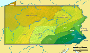 The final portion of the Line of Property
in Pennsylvania, called the Purchase line
in that State, was fixed in 1773 by representatives from the Six Nations and Pennsylvania who met at a spot called Canoe Place at the confluence of West Branch of the Susquehanna River and Cush Cushion Creek in what is now Cherry Tree, Pennsylvania
.
The reason for the Treaty of Fort Stanwix was that the press of population growth and economic development turned the attention of investors and land speculators to the area west of the Appalachians. In response to demands by settlers and speculators, British authorities were soon pressing the Iroquois and Cherokees for cessions of land in Indian country. The Treaty of Lochaber
with the Cherokee followed in 1770, whereby the Cherokee withdrew their claim to part of the same country, encompassing the south part of present-day West Virginia. No longer able to play off rival colonial powers following the British victory in the French and Indian War, Indians were reduced to a choice between compliance and resistance. Weakened by the recent war, they negotiated away parcels of land in exchange for promises of protection from further encroachments. So in 1768, the Iroquois gave up their claim south of the Ohio, hoping thereby to deflect English settlement away from their own homeland.
Treaty
A treaty is an express agreement under international law entered into by actors in international law, namely sovereign states and international organizations. A treaty may also be known as an agreement, protocol, covenant, convention or exchange of letters, among other terms...
between North American Indians and the British Empire
British Empire
The British Empire comprised the dominions, colonies, protectorates, mandates and other territories ruled or administered by the United Kingdom. It originated with the overseas colonies and trading posts established by England in the late 16th and early 17th centuries. At its height, it was the...
. It was signed in 1768 at Fort Stanwix
Fort Stanwix
Fort Stanwix was a colonial fort whose construction was started on August 26, 1758, by British General John Stanwix, at the location of present-day Rome, New York, but was not completed until about 1762. The fort guarded a portage known as the Oneida Carrying Place during the French and Indian War...
, located in present-day Rome, New York
Rome, New York
Rome is a city in Oneida County, New York, United States. It is located in north-central or "upstate" New York. The population was 44,797 at the 2010 census. It is in New York's 24th congressional district. In 1758, British forces began construction of Fort Stanwix at this strategic location, but...
. It was negotiated between Sir William Johnson
Sir William Johnson, 1st Baronet
Sir William Johnson, 1st Baronet was an Anglo-Irish official of the British Empire. As a young man, Johnson came to the Province of New York to manage an estate purchased by his uncle, Admiral Peter Warren, which was located amidst the Mohawk, one of the Six Nations of the Iroquois League...
and representatives of the Six Nations (the Iroquois
Iroquois
The Iroquois , also known as the Haudenosaunee or the "People of the Longhouse", are an association of several tribes of indigenous people of North America...
).
The purpose of the conference was to adjust the boundary line between Indian lands and British colonial settlements set forth in the Royal Proclamation of 1763
Royal Proclamation of 1763
The Royal Proclamation of 1763 was issued October 7, 1763, by King George III following Great Britain's acquisition of French territory in North America after the end of the French and Indian War/Seven Years' War...
. The British government hoped a new boundary line might bring an end to the rampant frontier violence which had become costly and troublesome. Indians hoped a new, permanent line might hold back British colonial expansion.
The final treaty was signed on November 5 with one signatory for each of the Six Nations and in the presence of representatives from New Jersey
New Jersey
New Jersey is a state in the Northeastern and Middle Atlantic regions of the United States. , its population was 8,791,894. It is bordered on the north and east by the state of New York, on the southeast and south by the Atlantic Ocean, on the west by Pennsylvania and on the southwest by Delaware...
, Virginia
Colony and Dominion of Virginia
The Colony of Virginia was the English colony in North America that existed briefly during the 16th century, and then continuously from 1607 until the American Revolution...
and Pennsylvania
Pennsylvania
The Commonwealth of Pennsylvania is a U.S. state that is located in the Northeastern and Mid-Atlantic regions of the United States. The state borders Delaware and Maryland to the south, West Virginia to the southwest, Ohio to the west, New York and Ontario, Canada, to the north, and New Jersey to...
as well as Johnson. The Native American nations present received gifts and cash totaling £10,460 7s. 3d. sterling, the highest payment ever made from colonists to American Indians. The treaty established a Line of Property
Line of Property
The Line of Property is the name commonly given to the line dividing Indian from British Colonial lands established in the Treaty of Fort Stanwix of 1768...
which extended the earlier proclamation line of the Alleghenies (the divide between the Ohio and coastal watersheds), much farther to the west. The line ran near Fort Pitt
Fort Pitt (Pennsylvania)
Fort Pitt was a fort built at the location of Pittsburgh, Allegheny County, Pennsylvania.-French and Indian War:The fort was built from 1759 to 1761 during the French and Indian War , next to the site of former Fort Duquesne, at the confluence the Allegheny River and the Monongahela River...
and followed the Ohio River
Ohio River
The Ohio River is the largest tributary, by volume, of the Mississippi River. At the confluence, the Ohio is even bigger than the Mississippi and, thus, is hydrologically the main stream of the whole river system, including the Allegheny River further upstream...
as far as the Tennessee River
Tennessee River
The Tennessee River is the largest tributary of the Ohio River. It is approximately 652 miles long and is located in the southeastern United States in the Tennessee Valley. The river was once popularly known as the Cherokee River, among other names...
, effectively ceding the Kentucky
Kentucky
The Commonwealth of Kentucky is a state located in the East Central United States of America. As classified by the United States Census Bureau, Kentucky is a Southern state, more specifically in the East South Central region. Kentucky is one of four U.S. states constituted as a commonwealth...
portion of the Colony of Virginia
Colony and Dominion of Virginia
The Colony of Virginia was the English colony in North America that existed briefly during the 16th century, and then continuously from 1607 until the American Revolution...
to the British, as well as most of what is now West Virginia
West Virginia
West Virginia is a state in the Appalachian and Southeastern regions of the United States, bordered by Virginia to the southeast, Kentucky to the southwest, Ohio to the northwest, Pennsylvania to the northeast and Maryland to the east...
.
Although the Six Nations of New York had previously recognised English rights southeast of the Ohio River at the 1752 Treaty of Logstown
Logstown
The riverside village of Logstown was a significant Native American settlement in Western Pennsylvania and the site of the 1752 signing of the treaty of friendship between the Ohio Company and the Amerindians occupying the region in the years leading up to the...
, they continued to claim ownership (by conquest) over all land as far south as the Tennessee River — which they still considered their boundary with the Cherokee
Cherokee
The Cherokee are a Native American people historically settled in the Southeastern United States . Linguistically, they are part of the Iroquoian language family...
and other "Southern" tribes. Although representatives of the Indian nations who actually occupied these lands, primarily the Shawnee
Shawnee
The Shawnee, Shaawanwaki, Shaawanooki and Shaawanowi lenaweeki, are an Algonquian-speaking people native to North America. Historically they inhabited the areas of Ohio, Virginia, West Virginia, Western Maryland, Kentucky, Indiana, and Pennsylvania...
and Lenape
Lenape
The Lenape are an Algonquian group of Native Americans of the Northeastern Woodlands. They are also called Delaware Indians. As a result of the American Revolutionary War and later Indian removals from the eastern United States, today the main groups live in Canada, where they are enrolled in the...
, were present at the negotiations in 1768, they were not signatories and had no real role in the Iroquois' sale of their homeland. Rather than secure peace, the Fort Stanwix treaty helped set the stage for the next round of hostilities along the Ohio River, which would culminate in Dunmore's War
Dunmore's War
Dunmore's War was a war in 1774 between the Colony of Virginia and the Shawnee and Mingo American Indian nations....
.
The treaty also settled land claims between the Six Nations and the Penn family, the proprietors of Pennsylvania
Pennsylvania
The Commonwealth of Pennsylvania is a U.S. state that is located in the Northeastern and Mid-Atlantic regions of the United States. The state borders Delaware and Maryland to the south, West Virginia to the southwest, Ohio to the west, New York and Ontario, Canada, to the north, and New Jersey to...
, where the lands acquired in 1768 were called the "New Purchase." Due to disputes about the physical boundaries of the settlement, however, the final treaty line would not be fully agreed upon for another five years.
Line of Property
The Line of Property is the name commonly given to the line dividing Indian from British Colonial lands established in the Treaty of Fort Stanwix of 1768...
in Pennsylvania, called the Purchase line
Purchase line
The Purchase Line is the name commonly given to the line dividing Indian from British Colonial lands established in the Treaty of Fort Stanwix of 1768 in western Pennsylvania...
in that State, was fixed in 1773 by representatives from the Six Nations and Pennsylvania who met at a spot called Canoe Place at the confluence of West Branch of the Susquehanna River and Cush Cushion Creek in what is now Cherry Tree, Pennsylvania
Cherry Tree, Pennsylvania
Cherry Tree is a borough in Indiana County, Pennsylvania, United States. The population was 443 at the 2000 census.-History:Cherry Tree is situated mostly in a valley near the headwaters of West Branch of the Susquehanna River where the river is fed by Cush Cushion Creek.Cherry Tree was originally...
.
The reason for the Treaty of Fort Stanwix was that the press of population growth and economic development turned the attention of investors and land speculators to the area west of the Appalachians. In response to demands by settlers and speculators, British authorities were soon pressing the Iroquois and Cherokees for cessions of land in Indian country. The Treaty of Lochaber
Treaty of Lochaber
The Treaty of Lochaber was signed on October 18, 1770 by British representative John Stuart and the Cherokees. Based on the terms of the accord, the Cherokee relinquished all claims to property from the North Carolina and Virginia border to a point near Long Island on the Holston River to the mouth...
with the Cherokee followed in 1770, whereby the Cherokee withdrew their claim to part of the same country, encompassing the south part of present-day West Virginia. No longer able to play off rival colonial powers following the British victory in the French and Indian War, Indians were reduced to a choice between compliance and resistance. Weakened by the recent war, they negotiated away parcels of land in exchange for promises of protection from further encroachments. So in 1768, the Iroquois gave up their claim south of the Ohio, hoping thereby to deflect English settlement away from their own homeland.