

Colorado Plateau
Encyclopedia
.jpg)
United States physiographic region
The list of continental United States Physiographic regions identifies the 8 regions, 25 provinces, and 85 sections. The system dates to Nevin Fenneman's paper Physiographic Subdivision of the United States, published in 1917...
of the Intermontane Plateaus
Intermontane Plateaus
Physiographic regions of the U.S. InteriorSee:legendIn some places,high plateaus lie between the mountain ranges, for example,the plateau of Anatolia in Turkey and the plateau of Tibet.These are called "Intermontane plateaus"....
, roughly centered on the Four Corners region of the southwestern United States
Southwestern United States
The Southwestern United States is a region defined in different ways by different sources. Broad definitions include nearly a quarter of the United States, including Arizona, California, Colorado, Nevada, New Mexico, Oklahoma, Texas and Utah...
. The province covers an area of 337,000 km2 (130,000 mi2) within western Colorado
Colorado
Colorado is a U.S. state that encompasses much of the Rocky Mountains as well as the northeastern portion of the Colorado Plateau and the western edge of the Great Plains...
, northwestern New Mexico
New Mexico
New Mexico is a state located in the southwest and western regions of the United States. New Mexico is also usually considered one of the Mountain States. With a population density of 16 per square mile, New Mexico is the sixth-most sparsely inhabited U.S...
, southern and eastern Utah
Utah
Utah is a state in the Western United States. It was the 45th state to join the Union, on January 4, 1896. Approximately 80% of Utah's 2,763,885 people live along the Wasatch Front, centering on Salt Lake City. This leaves vast expanses of the state nearly uninhabited, making the population the...
, and northern Arizona
Arizona
Arizona ; is a state located in the southwestern region of the United States. It is also part of the western United States and the mountain west. The capital and largest city is Phoenix...
. About 90% of the area is drained by the Colorado River and its main tributaries: the Green
Green River (Utah)
The Green River, located in the western United States, is the chief tributary of the Colorado River. The watershed of the river, known as the Green River Basin, covers parts of Wyoming, Utah, and Colorado. The Green River is long, beginning in the Wind River Mountains of Wyoming and flowing...
, San Juan, and Little Colorado
Little Colorado River
The Little Colorado River is a river in the U.S. state of Arizona, providing the principal drainage from the Painted Desert region. Together with its major tributary, the Puerco River, it drains an area of about in eastern Arizona and western New Mexico...
.
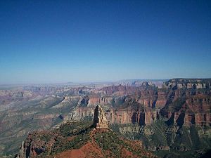
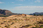
The Colorado Plateau is largely made up of deserts, with scattered areas of forests. In the southwest corner of the Colorado Plateau lies the Grand Canyon
Grand Canyon
The Grand Canyon is a steep-sided canyon carved by the Colorado River in the United States in the state of Arizona. It is largely contained within the Grand Canyon National Park, the 15th national park in the United States...
of the Colorado River. Much of the Plateau's landscape is related, in both appearance and geologic history, to the Grand Canyon. The nickname "Red Rock Country" suggests the brightly colored rock left bare to the view by dryness and erosion. Domes
Dome (geology)
In structural geology, a dome is a deformational feature consisting of symmetrically-dipping anticlines; their general outline on a geologic map is circular or oval...
, hoodoos
Hoodoo (geology)
A hoodoo is a tall, thin spire of rock that protrudes from the bottom of an arid drainage basin or badland. Hoodoos consist of relatively soft rock topped by harder, less easily eroded stone that protects each column from the elements...
, fins, reef
Reef
In nautical terminology, a reef is a rock, sandbar, or other feature lying beneath the surface of the water ....
s, goblins, river narrows
Narrows
Narrows is a term for restricted land or water passages. Most commonly it refers to a strait, though it can also refer to a water gap....
, natural bridge
Natural Bridge
Natural bridge or Natural Bridge can refer to several things:*Natural arch, a land formation sometimes referred to as a natural bridge*Natural Bridge, Alabama*Natural Bridge, New York...
s, and slot canyon
Slot canyon
A slot canyon is a narrow canyon, formed by the wear of water rushing through rock. A slot canyon is significantly deeper than it is wide. Some slot canyons can measure less than one metre across at the top but drop more than 30 m to the floor of the canyon.Most slot canyons are formed in...
s are only some of the additional features typical of the Plateau.
The Colorado Plateau has the greatest concentration of national parks in the United States. Among its parks are Grand Canyon National Park
Grand Canyon National Park
Grand Canyon National Park is the United States' 15th oldest national park and is located in Arizona. Within the park lies the Grand Canyon, a gorge of the Colorado River, considered to be one of the Wonders of the World. The park covers of unincorporated area in Coconino and Mohave counties.Most...
, Zion National Park
Zion National Park
Zion National Park is located in the Southwestern United States, near Springdale, Utah. A prominent feature of the park is Zion Canyon, which is 15 miles long and up to half a mile deep, cut through the reddish and tan-colored Navajo Sandstone by the North Fork of the Virgin River...
, Bryce Canyon National Park
Bryce Canyon National Park
Bryce Canyon National Park is a national park located in southwestern Utah in the United States. The major feature of the park is Bryce Canyon which, despite its name, is not a canyon but a giant natural amphitheater created by erosion along the eastern side of the Paunsaugunt Plateau...
, Capitol Reef National Park
Capitol Reef National Park
Capitol Reef National Park is a United States National Park, in south-central Utah. It is 100 miles long but fairly narrow. The park, established in 1971, preserves 378 mi² and is open all year, although May through September are the most popular months.Called "Wayne Wonderland" in the 1920s...
, Canyonlands National Park
Canyonlands National Park
Canyonlands National Park is a U.S. National Park located in southeastern Utah near the town of Moab and preserves a colorful landscape eroded into countless canyons, mesas and buttes by the Colorado River, the Green River, and their respective tributaries. The park is divided into four districts:...
, Arches National Park
Arches National Park
Arches National Park is a U.S. National Park in eastern Utah. It is known for preserving over 2000 natural sandstone arches, including the world-famous Delicate Arch, in addition to a variety of unique geological resources and formations....
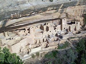
, Mesa Verde National Park
Mesa Verde National Park
Mesa Verde National Park is a U.S. National Park and UNESCO World Heritage Site located in Montezuma County, Colorado, United States. It was created in 1906 to protect some of the best-preserved cliff dwellings in the world...
, and Petrified Forest National Park
Petrified Forest National Park
Petrified Forest National Park is a United States national park in Navajo and Apache counties in northeastern Arizona. The park's headquarters are about east of Holbrook along Interstate 40 , which parallels a railroad line, the Puerco River, and historic U.S. Route 66, all crossing the park...
. Among the national monuments are Dinosaur National Monument
Dinosaur National Monument
Dinosaur National Monument is a National Monument located on the southeast flank of the Uinta Mountains on the border between Colorado and Utah at the confluence of the Green and Yampa Rivers. Although most of the monument area is in Moffat County, Colorado, the Dinosaur Quarry is located in Utah...
, Hovenweep National Monument
Hovenweep National Monument
Hovenweep National Monument is located on land in southwestern Colorado and southeastern Utah, located between Cortez, Colorado and Blanding, Utah on the Cajon Mesa of the Great Sage Plain...
, Wupatki National Monument
Wupatki National Monument
The Wupatki National Monument is a National Monument located in north-central Arizona, near Flagstaff. Rich in Native American ruins, the monument is administered by the National Park Service in close conjunction with the nearby Sunset Crater Volcano National Monument.Wupatki was listed on the...
, Grand Staircase-Escalante National Monument
Grand Staircase-Escalante National Monument
The Grand Staircase-Escalante National Monument contains 1.9 million acres of land in southern Utah, the United States. There are three main regions: the Grand Staircase, the Kaiparowits Plateau, and the Canyons of the Escalante. President Bill Clinton designated the area as a U.S. National...
, Natural Bridges National Monument
Natural Bridges National Monument
Natural Bridges National Monument is a U.S. National Monument located about north west of the Four Corners boundary of southeast Utah, in the western United States, at the junction of White Canyon and Armstrong Canyon, part of the Colorado River drainage...
, Canyons of the Ancients National Monument
Canyons of the Ancients National Monument
Canyons of the Ancients National Monument is located in the southwestern region of the U.S. state of Colorado, and is managed by the U.S. Bureau of Land Management, an agency within the U.S. Department of the Interior...
, and Colorado National Monument
Colorado National Monument
- Trails :The Monument contains many hiking trails, with lengths and difficulties to suit all tastes. Summer storms can cause flash floods as well as dangerous trail conditions. Rattlesnakes are found on the Monument, and rough terrain exists everywhere, but most trails are well-maintained...
.
Geography


Rocky Mountains
The Rocky Mountains are a major mountain range in western North America. The Rocky Mountains stretch more than from the northernmost part of British Columbia, in western Canada, to New Mexico, in the southwestern United States...
in Colorado, and by the Uinta Mountains
Uinta Mountains
The Uinta Mountains are a high chain of mountains in northeastern Utah and extreme northwestern Colorado in the United States. A subrange of the Rocky Mountains, they are unusual for being the highest range in the contiguous United States running east to west, and lie approximately east of Salt...
and Wasatch Mountains branches of the Rockies in northern and central Utah. It is also bounded by the Rio Grande Rift
Rio Grande Rift
The Rio Grande Rift is a north-trending continental rift zone. It separates the Colorado Plateau in the west from the interior of the North American craton on the east. The rift extends from central Colorado in the north to the state of Chihuahua, Mexico in the south. The rift zone consists of four...
, Mogollon Rim
Mogollon Rim
The Mogollon Rim is a topographical and geological feature running across the U.S. state of Arizona. It extends approximately from northern Yavapai County eastward to near the border with New Mexico.-Description:...
and the Basin and Range
Basin and Range
The Basin and Range Province is a vast physiographic region defined by a unique topographic expression. Basin and Range topography is characterized by abrupt changes in elevation, alternating between narrow faulted mountain chains and flat arid valleys or basins...
. Isolated ranges of the Southern Rocky Mountains
Southern Rocky Mountains
The Southern Rocky Mountains are a major subregion of the Rocky Mountains of North America located in the southern portion of the U.S. state of Wyoming, the central and western portions of Colorado, the northern portion of New Mexico, and extreme eastern portions of Utah...
such as the San Juan Mountains
San Juan Mountains
The San Juan Mountains are a high and rugged mountain range in the Rocky Mountains in southwestern Colorado. The area is highly mineralized and figured in the gold and silver mining industry of early Colorado. Major towns, all old mining camps, include Creede, Lake City, Silverton, Ouray, and...
in Colorado
Colorado
Colorado is a U.S. state that encompasses much of the Rocky Mountains as well as the northeastern portion of the Colorado Plateau and the western edge of the Great Plains...
and the La Sal Mountains in Utah
Utah
Utah is a state in the Western United States. It was the 45th state to join the Union, on January 4, 1896. Approximately 80% of Utah's 2,763,885 people live along the Wasatch Front, centering on Salt Lake City. This leaves vast expanses of the state nearly uninhabited, making the population the...
intermix into the central and southern parts of the Colorado Plateau.
It is composed of seven sections:
- Uinta Basin Section
- High Plateaus Section
- Grand CanyonGrand CanyonThe Grand Canyon is a steep-sided canyon carved by the Colorado River in the United States in the state of Arizona. It is largely contained within the Grand Canyon National Park, the 15th national park in the United States...
Section - Canyon LandsCanyon LandsThe Canyon Lands Section of the Colorado Plateaus is a physiographic section of the larger Colorado Plateaus province, which in turn is part of the larger Intermontane Plateaus physiographic division. They are a desolate but spectacularly scenic sandstone area of southeastern Utah...
Section - Navajo SectionNavajo sectionThe Navajo Section is a physiographic section of the larger Colorado Plateaus province, which in turn is part of the larger Intermontane Plateaus physiographic division...
- Datil-Mogollon SectionDatil-Mogollon SectionThe Datil-Mogollon Section is a physiographic section of the larger Colorado Plateaus province, which in turn is part of the larger Intermontane Plateaus physiographic division. It is a transitional area between the Basin and Range Province and the Colorado Plateau...
- Acoma-Zuni SectionAcoma-Zuni SectionThe Acoma-Zuni Section is a physiographic section of the larger Colorado Plateaus province, which in turn is part of the larger Intermontane Plateaus physiographic division. It is...
As the name implies, the High Plateaus Section is, on average, the highest section. North-south trending normal faults that include the Hurricane, Sevier, Grand Wash, and Paunsaugunt separate the section's component plateaus. This fault pattern is caused by the tensional forces pulling apart the adjacent Basin and Range province to the west, making this section transitional.
Occupying the southeast corner of the Colorado Plateau is the Datil Section. Thick sequences of mid-Tertiary
Tertiary
The Tertiary is a deprecated term for a geologic period 65 million to 2.6 million years ago. The Tertiary covered the time span between the superseded Secondary period and the Quaternary...
to late-Cenozoic
Cenozoic
The Cenozoic era is the current and most recent of the three Phanerozoic geological eras and covers the period from 65.5 mya to the present. The era began in the wake of the Cretaceous–Tertiary extinction event at the end of the Cretaceous that saw the demise of the last non-avian dinosaurs and...
-aged lava
Lava
Lava refers both to molten rock expelled by a volcano during an eruption and the resulting rock after solidification and cooling. This molten rock is formed in the interior of some planets, including Earth, and some of their satellites. When first erupted from a volcanic vent, lava is a liquid at...
covers this section.
Development of the province has in large part been influenced by structural features in its oldest rocks. Part of the Wasatch Line and its various faults form the western edge of the province. Faults that run parallel to the Wasatch Fault that lies along the Wasatch Range
Wasatch Range
The Wasatch Range is a mountain range that stretches approximately from the Utah-Idaho border, south through central Utah in the western United States. It is generally considered the western edge of the greater Rocky Mountains, and the eastern edge of the Great Basin region...
form the boundaries between the plateaus in the High Plateaus Section. The Uinta Basin, Uncompahgre Uplift, and the Paradox Basin were also created by movement along structural weaknesses in the region's oldest rock.
In Utah, the province includes several higher fault-separated plateau
Plateau
In geology and earth science, a plateau , also called a high plain or tableland, is an area of highland, usually consisting of relatively flat terrain. A highly eroded plateau is called a dissected plateau...
s:
- Awapa Plateau
- Aquarius PlateauAquarius PlateauThe Aquarius Plateau is a physiographic region within Garfield and Wayne counties in south-central Utah. The plateau, an uplift on the much larger Colorado Plateau, is the highest in North America...
- Kaiparowits PlateauKaiparowits Plateauright|Location of the Kaiparowits Plateau within UtahThe Kaiparowits Plateau is a large, elevated landform located in southern Utah, in the southwestern United States. Along with the Grand Staircase and the Canyons of the Escalante, it makes up a significant portion of the Grand...
- Markagunt PlateauMarkagunt PlateauThe Markagunt Plateau is an plateau located in southwestern Utah between Interstate 15 and U.S. Route 89. It is one of the plateaus that make up the High Plateaus Section of the Colorado Plateau. The plateau encompasses Cedar Breaks National Monument and is part of Cedar Mountain District of...
- Paunsaugunt PlateauPaunsaugunt PlateauThe Paunsaugunt Plateau is a dissected plateau, rising to an elevation of , in southwestern Utah in the United States. Located in northern Kane County and southwestern Garfield County, it is approximately wide, and extends southward from the Sevier Plateau approximately , terminating in the Pink...
- Sevier Plateau
- Fishlake Plateau
- Pavant Plateau
- Gunnison Plateau and the
- Tavaputs Plateau.
Some sources also include the Tushar Mountain Plateau as part of the Colorado Plateau, but others do not. The mostly flat-lying sedimentary rock
Sedimentary rock
Sedimentary rock are types of rock that are formed by the deposition of material at the Earth's surface and within bodies of water. Sedimentation is the collective name for processes that cause mineral and/or organic particles to settle and accumulate or minerals to precipitate from a solution....
units that make up these plateaus are found in component plateaus that are between 1500 m (5000 ft) to over 3350 m (11,000 ft) above sea level
Sea level
Mean sea level is a measure of the average height of the ocean's surface ; used as a standard in reckoning land elevation...
. A supersequence of these rocks is exposed in the various cliffs and canyons (including the Grand Canyon
Grand Canyon
The Grand Canyon is a steep-sided canyon carved by the Colorado River in the United States in the state of Arizona. It is largely contained within the Grand Canyon National Park, the 15th national park in the United States...
) that make up the Grand Staircase
Grand Staircase
For the similarly named structure on the RMS Titanic, see Grand Staircase of the TitanicFor the stairs in the White House see Grand Staircase ...
. Increasingly younger east-west trending escarpments of the Grand Staircase extend north of the Grand Canyon and are named for their color:
- Chocolate Cliffs,
- Vermillion Cliffs,
- White Cliffs,
- Gray Cliffs, and the
- Pink CliffsPink CliffsThe Pink Cliffs are a series of highly-dissected cliffs, approximately 35 mi long, along the southeast edge of the Paunsaugunt Plateau in southwestern Utah in the United States...
.
Within these rocks are abundant mineral
Mineral
A mineral is a naturally occurring solid chemical substance formed through biogeochemical processes, having characteristic chemical composition, highly ordered atomic structure, and specific physical properties. By comparison, a rock is an aggregate of minerals and/or mineraloids and does not...
resources that include uranium
Uranium
Uranium is a silvery-white metallic chemical element in the actinide series of the periodic table, with atomic number 92. It is assigned the chemical symbol U. A uranium atom has 92 protons and 92 electrons, of which 6 are valence electrons...
, coal
Coal
Coal is a combustible black or brownish-black sedimentary rock usually occurring in rock strata in layers or veins called coal beds or coal seams. The harder forms, such as anthracite coal, can be regarded as metamorphic rock because of later exposure to elevated temperature and pressure...
, petroleum
Petroleum
Petroleum or crude oil is a naturally occurring, flammable liquid consisting of a complex mixture of hydrocarbons of various molecular weights and other liquid organic compounds, that are found in geologic formations beneath the Earth's surface. Petroleum is recovered mostly through oil drilling...
, and natural gas
Natural gas
Natural gas is a naturally occurring gas mixture consisting primarily of methane, typically with 0–20% higher hydrocarbons . It is found associated with other hydrocarbon fuel, in coal beds, as methane clathrates, and is an important fuel source and a major feedstock for fertilizers.Most natural...
. Study of the area's unusually clear geologic history (which is laid bare due to the arid and semiarid conditions) has greatly advanced that science.
A rain shadow
Rain shadow
A rain shadow is a dry area on the lee side of a mountainous area. The mountains block the passage of rain-producing weather systems, casting a "shadow" of dryness behind them. As shown by the diagram to the right, the warm moist air is "pulled" by the prevailing winds over a mountain...
from the Sierra Nevada far to the west and the many ranges of the Basin and Range means that the Colorado Plateau receives 15 to 40 cm (6 to 16 in.) of annual precipitation. Higher areas receive more precipitation and are covered in forests of pine, fir, and spruce.
Though it can be said that the Plateau roughly centers on the Four Corners, Black Mesa in northern Arizona is much closer to the east-west, north-south midpoint of the Plateau Province. Lying southeast of Glen Canyon and southwest of Monument Valley at the north end of the Hopi Reservation, this remote coal-laden highland has about half of the Colorado Plateau's acreage north of it, half south of it, half west of it, and half east of it.
History
The Ancestral Puebloan People lived in the region from around 2000 to 700 years ago.A party from Santa Fe led by Fathers Dominguez and Escalante, unsuccessfully seeking an overland route to California, made a five-month out-and-back trip through much of the Plateau in 1776-1777.
U.S. Army
United States Army
The United States Army is the main branch of the United States Armed Forces responsible for land-based military operations. It is the largest and oldest established branch of the U.S. military, and is one of seven U.S. uniformed services...
Major and geologist John Wesley Powell
John Wesley Powell
John Wesley Powell was a U.S. soldier, geologist, explorer of the American West, and director of major scientific and cultural institutions...
explored the area in 1869 and 1872 despite having lost one arm in the American Civil War
American Civil War
The American Civil War was a civil war fought in the United States of America. In response to the election of Abraham Lincoln as President of the United States, 11 southern slave states declared their secession from the United States and formed the Confederate States of America ; the other 25...
. Using fragile boats and small groups of men the Powell Geographic Expedition charted this largely unknown region of the United States for the federal government.
Construction of the Hoover Dam
Hoover Dam
Hoover Dam, once known as Boulder Dam, is a concrete arch-gravity dam in the Black Canyon of the Colorado River, on the border between the US states of Arizona and Nevada. It was constructed between 1931 and 1936 during the Great Depression and was dedicated on September 30, 1935, by President...
in the 1930s and the Glen Canyon Dam
Glen Canyon Dam
Glen Canyon Dam is a concrete arch dam on the Colorado River in northern Arizona in the United States, just north of Page. The dam was built to provide hydroelectricity and flow regulation from the upper Colorado River Basin to the lower. Its reservoir is called Lake Powell, and is the second...
in the 1960s changed the character of the Colorado River. Dramatically reduced sediment load changed its color from reddish brown (Colorado is Spanish
Spanish language
Spanish , also known as Castilian , is a Romance language in the Ibero-Romance group that evolved from several languages and dialects in central-northern Iberia around the 9th century and gradually spread with the expansion of the Kingdom of Castile into central and southern Iberia during the...
for "colored" referring to its red color) to mostly clear. The apparent green color is from algae
Algae
Algae are a large and diverse group of simple, typically autotrophic organisms, ranging from unicellular to multicellular forms, such as the giant kelps that grow to 65 meters in length. They are photosynthetic like plants, and "simple" because their tissues are not organized into the many...
on the riverbed's rocks, not from any significant amount of suspended material. The lack of sediment has also starved sand bars and beach
Beach
A beach is a geological landform along the shoreline of an ocean, sea, lake or river. It usually consists of loose particles which are often composed of rock, such as sand, gravel, shingle, pebbles or cobblestones...
es but an experimental 12 day long controlled flood from Glen Canyon Dam in 1996 showed substantial restoration. Similar floods are planned for every 5 to 10 years.
Geology

Fold (geology)
The term fold is used in geology when one or a stack of originally flat and planar surfaces, such as sedimentary strata, are bent or curved as a result of permanent deformation. Synsedimentary folds are those due to slumping of sedimentary material before it is lithified. Folds in rocks vary in...
ing has affected this high, thick crustal block within the last 600 million years or so. In contrast, provinces that have suffered severe deformation surround the plateau. Mountain building thrust up the Rocky Mountains
Rocky Mountains
The Rocky Mountains are a major mountain range in western North America. The Rocky Mountains stretch more than from the northernmost part of British Columbia, in western Canada, to New Mexico, in the southwestern United States...
to the north and east and tremendous, earth-stretching tension created the Basin and Range
Basin and Range
The Basin and Range Province is a vast physiographic region defined by a unique topographic expression. Basin and Range topography is characterized by abrupt changes in elevation, alternating between narrow faulted mountain chains and flat arid valleys or basins...
province to the west and south. Sub ranges of the Southern Rocky Mountains
Southern Rocky Mountains
The Southern Rocky Mountains are a major subregion of the Rocky Mountains of North America located in the southern portion of the U.S. state of Wyoming, the central and western portions of Colorado, the northern portion of New Mexico, and extreme eastern portions of Utah...
are scattered throughout the Colorado Plateau.
Precambrian
The Precambrian is the name which describes the large span of time in Earth's history before the current Phanerozoic Eon, and is a Supereon divided into several eons of the geologic time scale...
and Paleozoic
Paleozoic
The Paleozoic era is the earliest of three geologic eras of the Phanerozoic eon, spanning from roughly...
history of the Colorado Plateau is best revealed near its southern end where the Grand Canyon
Grand Canyon
The Grand Canyon is a steep-sided canyon carved by the Colorado River in the United States in the state of Arizona. It is largely contained within the Grand Canyon National Park, the 15th national park in the United States...
has exposed rocks with ages that span almost 2 billion years. The oldest rocks at river level are igneous and metamorphic and have been lumped together as "Vishnu Basement Rocks"; the oldest ages recorded by these rocks fall in the range 1950 to 1680 million years. An erosion surface on the "Vishnu Basement Rocks" is covered by sedimentary rocks and basalt flows, and these rocks formed in the interval from about 1250 to 750 million years ago: in turn, they were uplifted and split into a range of fault-block mountain
Fault-block mountain
Fault-block landforms are formed when large areas of bedrock are widely broken up by faults creating large vertical displacements of continental crust....
s. Erosion greatly reduced this mountain range prior to the encroachment of a seaway along the passive western edge of the continent in the early Paleozoic. At the canyon rim is the Kaibab Formation, limestone deposited in the late Paleozoic (Permian) about 270 million years ago.
A 12,000 to 15,000 ft. (3700 to 4600 m) high extension of the Ancestral Rocky Mountains called the Uncompahgre Mountains were uplifted and the adjacent Paradox Basin subsided. Almost 4 mi. (6.4 km) of sediment from the mountains and evaporite
Evaporite
Evaporite is a name for a water-soluble mineral sediment that result from concentration and crystallization by evaporation from an aqueous solution. There are two types of evaporate deposits, marine which can also be described as ocean deposits, and non-marine which are found in standing bodies of...
s from the sea were deposited (see geology of the Canyonlands area
Geology of the Canyonlands area
The exposed geology of the Canyonlands area is complex and diverse; 12 formations are exposed in Canyonlands National Park that range in age from Pennsylvanian to Cretaceous. The oldest and perhaps most interesting was created from evaporites deposited from evaporating seawater...
for detail).
Most of the formations were deposited in warm shallow seas and near-shore environments (such as beach
Beach
A beach is a geological landform along the shoreline of an ocean, sea, lake or river. It usually consists of loose particles which are often composed of rock, such as sand, gravel, shingle, pebbles or cobblestones...
es and swamp
Swamp
A swamp is a wetland with some flooding of large areas of land by shallow bodies of water. A swamp generally has a large number of hammocks, or dry-land protrusions, covered by aquatic vegetation, or vegetation that tolerates periodical inundation. The two main types of swamp are "true" or swamp...
s) as the seashore repeatedly advanced and retreated over the edge of a proto-North America (for detail, see geology of the Grand Canyon area
Geology of the Grand Canyon area
The geology of the Grand Canyon area exposes one of the most complete and studied sequences of rock on Earth. The nearly 40 major sedimentary rock layers exposed in the Grand Canyon and in the Grand Canyon National Park area range in age from about 200 million to nearly 2 billion years old...
). The province was probably on a continental margin
Continental margin
The continental margin is the zone of the ocean floor that separates the thin oceanic crust from thick continental crust. Continental margins constitute about 28% of the oceanic area....
throughout the late Precambrian and most of the Paleozoic
Paleozoic
The Paleozoic era is the earliest of three geologic eras of the Phanerozoic eon, spanning from roughly...
era. Igneous rocks injected millions of years later form a marbled network through parts of the Colorado Plateau's darker metamorphic basement. By 600 million years ago North America had been leveled off to a remarkably smooth surface.
Throughout the Paleozoic Era, tropical seas periodically inundated the Colorado Plateau region. Thick layers of limestone, sandstone, siltstone, and shale were laid down in the shallow marine waters. During times when the seas retreated, stream deposits and dune sands were deposited or older layers were removed by erosion. Over 300 million years passed as layer upon layer of sediment accumulated.
It was not until the upheavals that coincided with the formation of the supercontinent Pangea began about 250 million years ago that deposits of marine sediment waned and terrestrial deposits dominate. In late Paleozoic and much of the Mesozoic
Mesozoic
The Mesozoic era is an interval of geological time from about 250 million years ago to about 65 million years ago. It is often referred to as the age of reptiles because reptiles, namely dinosaurs, were the dominant terrestrial and marine vertebrates of the time...
era the region was affected by a series of orogenies
Orogeny
Orogeny refers to forces and events leading to a severe structural deformation of the Earth's crust due to the engagement of tectonic plates. Response to such engagement results in the formation of long tracts of highly deformed rock called orogens or orogenic belts...
(mountain
Mountain
Image:Himalaya_annotated.jpg|thumb|right|The Himalayan mountain range with Mount Everestrect 58 14 160 49 Chomo Lonzorect 200 28 335 52 Makalurect 378 24 566 45 Mount Everestrect 188 581 920 656 Tibetan Plateaurect 250 406 340 427 Rong River...
-building events) that deformed western North America and caused a great deal of uplift. Eruptions from volcanic mountain ranges to the west buried vast regions beneath ashy debris. Short-lived rivers, lakes, and inland seas left sedimentary records of their passage. Stream
Stream
A stream is a body of water with a current, confined within a bed and stream banks. Depending on its locale or certain characteristics, a stream may be referred to as a branch, brook, beck, burn, creek, "crick", gill , kill, lick, rill, river, syke, bayou, rivulet, streamage, wash, run or...
s, pond
Pond
A pond is a body of standing water, either natural or man-made, that is usually smaller than a lake. A wide variety of man-made bodies of water are classified as ponds, including water gardens, water features and koi ponds; all designed for aesthetic ornamentation as landscape or architectural...
s and lake
Lake
A lake is a body of relatively still fresh or salt water of considerable size, localized in a basin, that is surrounded by land. Lakes are inland and not part of the ocean and therefore are distinct from lagoons, and are larger and deeper than ponds. Lakes can be contrasted with rivers or streams,...
s created formations such as the Chinle, Moenave, and Kayenta in the Mesozoic era. Later a vast desert
Desert
A desert is a landscape or region that receives an extremely low amount of precipitation, less than enough to support growth of most plants. Most deserts have an average annual precipitation of less than...
formed the Navajo and Temple Cap formations and dry near-shore environment formed the Carmel (see geology of the Zion and Kolob canyons area
Geology of the Zion and Kolob canyons area
The geology of the Zion and Kolob canyons area includes nine known exposed formations, all visible in Zion National Park in the U.S. state of Utah. Together, these formations represent about 150 million years of mostly Mesozoic-aged sedimentation in that part of North America...
for details).
The area was again covered by a warm shallow sea when the Cretaceous Seaway opened in late Mesozoic time. The Dakota Sandstone and the Tropic Shale were deposited in the warm shallow waters of this advancing and retreating seaway. Several other formations were also created but were mostly eroded
Erosion
Erosion is when materials are removed from the surface and changed into something else. It only works by hydraulic actions and transport of solids in the natural environment, and leads to the deposition of these materials elsewhere...
following two major periods of uplift.
The Laramide orogeny
Laramide orogeny
The Laramide orogeny was a period of mountain building in western North America, which started in the Late Cretaceous, 70 to 80 million years ago, and ended 35 to 55 million years ago. The exact duration and ages of beginning and end of the orogeny are in dispute, as is the cause. The Laramide...
closed the seaway and uplifted a large belt of crust from Montana
Montana
Montana is a state in the Western United States. The western third of Montana contains numerous mountain ranges. Smaller, "island ranges" are found in the central third of the state, for a total of 77 named ranges of the Rocky Mountains. This geographical fact is reflected in the state's name,...
to Mexico
Mexico
The United Mexican States , commonly known as Mexico , is a federal constitutional republic in North America. It is bordered on the north by the United States; on the south and west by the Pacific Ocean; on the southeast by Guatemala, Belize, and the Caribbean Sea; and on the east by the Gulf of...
, with the Colorado Plateau region being the largest block. Thrust fault
Thrust fault
A thrust fault is a type of fault, or break in the Earth's crust across which there has been relative movement, in which rocks of lower stratigraphic position are pushed up and over higher strata. They are often recognized because they place older rocks above younger...
s in Colorado
Colorado
Colorado is a U.S. state that encompasses much of the Rocky Mountains as well as the northeastern portion of the Colorado Plateau and the western edge of the Great Plains...
are thought to have formed from a slight clockwise movement of the region, which acted as a rigid crustal block. The Colorado Plateau Province was uplifted largely as a single block, possibly due to its relative thickness. This relative thickness may be why compressional forces from the orogeny were mostly transmitted through the province instead of compacting it. Pre-existing weaknesses in Precambrian rocks were reactivated by the compression. It was along these ancient faults and other deeply-buried structures that much of the province's relatively small and gently-inclined flexures (such as anticline
Anticline
In structural geology, an anticline is a fold that is convex up and has its oldest beds at its core. The term is not to be confused with antiform, which is a purely descriptive term for any fold that is convex up. Therefore if age relationships In structural geology, an anticline is a fold that is...
s, syncline
Syncline
In structural geology, a syncline is a fold, with younger layers closer to the center of the structure. A synclinorium is a large syncline with superimposed smaller folds. Synclines are typically a downward fold, termed a synformal syncline In structural geology, a syncline is a fold, with younger...
s, and monocline
Monocline
A monocline is a step-like fold in rock strata consisting of a zone of steeper dip within an otherwise horizontal or gently-dipping sequence.-Formation:Monoclines may be formed in several different ways...
s) formed. Some of the prominent isolated mountain ranges of the Plateau, such as Ute Mountain
Ute Mountain
Ute Mountain , is a peak within the Ute Mountains, a small mountain range in the southwestern corner of Colorado. It is on the northern edge of the Ute Mountain Ute Reservation. The Reservation forms the southwestern corner of the state and of Montezuma County.Nomenclature for this peak and its...
and the Carrizo Mountains
Carrizo Mountains
The Carrizo Mountains are a small range 15 to 20 km in diameter located on the Colorado Plateau in northeastern Arizona. The range is about southwest of the Four Corners. The highest summit, Pastora Peak, is in elevation, whereas elevations on the surrounding plateau are near . The mountains...
, both near the Four Corners, are cored by igneous rocks that were intruded about 70 million years ago, during the Laramide orogeny
Laramide orogeny
The Laramide orogeny was a period of mountain building in western North America, which started in the Late Cretaceous, 70 to 80 million years ago, and ended 35 to 55 million years ago. The exact duration and ages of beginning and end of the orogeny are in dispute, as is the cause. The Laramide...
.
Minor uplift events continued through the start of the Cenozoic
Cenozoic
The Cenozoic era is the current and most recent of the three Phanerozoic geological eras and covers the period from 65.5 mya to the present. The era began in the wake of the Cretaceous–Tertiary extinction event at the end of the Cretaceous that saw the demise of the last non-avian dinosaurs and...
era and were accompanied by some basalt
Basalt
Basalt is a common extrusive volcanic rock. It is usually grey to black and fine-grained due to rapid cooling of lava at the surface of a planet. It may be porphyritic containing larger crystals in a fine matrix, or vesicular, or frothy scoria. Unweathered basalt is black or grey...
ic lava eruptions and mild deformation. The colorful Claron Formation that forms the delicate hoodoo
Hoodoo (geology)
A hoodoo is a tall, thin spire of rock that protrudes from the bottom of an arid drainage basin or badland. Hoodoos consist of relatively soft rock topped by harder, less easily eroded stone that protects each column from the elements...
s of Bryce Amphitheater and Cedar Breaks was then laid down as sediments in cool stream
Stream
A stream is a body of water with a current, confined within a bed and stream banks. Depending on its locale or certain characteristics, a stream may be referred to as a branch, brook, beck, burn, creek, "crick", gill , kill, lick, rill, river, syke, bayou, rivulet, streamage, wash, run or...
s and lakes (see geology of the Bryce Canyon area
Geology of the Bryce Canyon area
The exposed geology of the Bryce Canyon area in Utah shows a record of deposition that covers the last part of the Cretaceous Period and the first half of the Cenozoic era in that part of North America...
for details). The flat-lying Chuska Sandstone was deposited about 34 million years ago; the sandstone is predominantly of eolian origin and locally more than 500 meters thick. The Chuska Sandstone caps the Chuska mountains
Chuska mountains
The Chuska Mountains are an elongate range on the Colorado Plateau and within the Navajo Nation. The range is about 80 by 15 km , and it trends north-northwest and is crossed by the state line between Arizona and New Mexico. The highlands are a dissected plateau, with an average elevation of...
, and it lies unconformably on Mesozoic rocks deformed during the Laramide orogeny
Laramide orogeny
The Laramide orogeny was a period of mountain building in western North America, which started in the Late Cretaceous, 70 to 80 million years ago, and ended 35 to 55 million years ago. The exact duration and ages of beginning and end of the orogeny are in dispute, as is the cause. The Laramide...
.
Younger igneous rocks form spectacular topographic features. The Henry Mountains
Henry Mountains
The Henry Mountains are located in the southeastern portion of the U.S. state of Utah and run in a generally north-south direction, extending over a distance of about 30 miles . They were named by John Wesley Powell in honour of Joseph Henry, the first secretary of the Smithsonian Institution. The...
, La Sal Range
La Sal Range
The La Sal Mountains are located in Grand and San Juan counties, near the eastern border of the state of Utah, and rising above the town of Moab. This range is part of the Manti-La Sal National Forest and the southern Rocky Mountains. The maximum elevation is at Mount Peale, reaching 12,721 feet ...
, and Abajo Mountains
Abajo Mountains
The Abajo Mountains, also called the Blue Mountains, is a small mountain range west of Monticello, Utah, south of Canyonlands National Park and north of Blanding, Utah. The mountain range is located within the Manti-La Sal National Forest...
, ranges that dominate many views in southeastern Utah, are formed about igneous rocks that were intruded in the interval from 20 to 31 million years: some igneous intrusions in these mountains form laccolith
Laccolith
A laccolith is a sheet intrusion that has been injected between two layers of sedimentary rock. The pressure of the magma is high enough that the overlying strata are forced upward, giving the laccolith a dome or mushroom-like form with a generally planar base.Laccoliths tend to form at relatively...
s, a form of intrusion recognized by Grove Karl Gilbert
Grove Karl Gilbert
Grove Karl Gilbert , known by the abbreviated name G. K. Gilbert in academic literature, was an American geologist....
during his studies of the Henry Mountains
Henry Mountains
The Henry Mountains are located in the southeastern portion of the U.S. state of Utah and run in a generally north-south direction, extending over a distance of about 30 miles . They were named by John Wesley Powell in honour of Joseph Henry, the first secretary of the Smithsonian Institution. The...
. Ship Rock (also called Shiprock
Shiprock
Shiprock is a rock formation rising nearly above the high-desert plain on the Navajo Nation in San Juan County, New Mexico, USA. It has a peak elevation of above the sea level. It lies about southwest of the town of Shiprock, which is named for the peak...
), in northwestern New Mexico, and Church Rock and Agathla
El Capitan (Arizona)
Agathla Peak is a peak south of Monument Valley, Arizona, over 1500 feet high. It is north of Kayenta and is visible from U.S. Route 163. The English designation Agathla is derived from the Navajo name meaning 'much wool', apparently for the fur of antelope and deer accumulating on the rock...
, near Monument Valley
Monument Valley
Monument Valley is a region of the Colorado Plateau characterized by a cluster of vast sandstone buttes, the largest reaching above the valley floor. It is located on the northern border of Arizona with southern Utah , near the Four Corners area...
, are erosional remnants of potassium-rich igneous rocks and associated breccias of the Navajo Volcanic Field, produced about 25 million years ago. The Hopi Buttes in northeastern Arizona are held up by resistant sheets of sodic volcanic rocks, extruded about 7 million years ago. More recent igneous rocks are concentrated nearer the margins of the Colorado Plateau. The San Francisco Peaks
San Francisco Peaks
The San Francisco Peaks are a volcanic mountain range located in north central Arizona, just north of Flagstaff.The highest summit in the range, Humphreys Peak, is the highest point in the state of Arizona at in elevation. The San Francisco Peaks are the remains of an eroded stratovolcano...
near Flagstaff
Flagstaff, Arizona
Flagstaff is a city located in northern Arizona, in the southwestern United States. In 2010, the city's population was 65,870. The population of the Metropolitan Statistical Area was at 134,421 in 2010. It is the county seat of Coconino County...
, south of the Grand Canyon
Grand Canyon
The Grand Canyon is a steep-sided canyon carved by the Colorado River in the United States in the state of Arizona. It is largely contained within the Grand Canyon National Park, the 15th national park in the United States...
, are volcanic landforms produced by igneous activity that began in that area about 6 million years ago and continued until 1064 C.E., when basalt erupted in Sunset Crater National Monument. Mount Taylor, near Grants, New Mexico
Grants, New Mexico
Grants is a city in Cibola County, New Mexico, United States. The population was 9,182 at the 2010 Census. It is the county seat of Cibola County....
, is a volcanic structure with a history similar to that of the San Francisco Peaks: a basalt flow closer to Grants was extruded only about 3000 years ago (see El Malpais National Monument
El Malpais National Monument
El Malpais National Monument is a National Monument located in western New Mexico, in the Southwestern United States. The name El Malpais is from the Spanish term Malpaís, meaning badlands, due to the extremely barren and dramatic volcanic field that covers much of the park's area.-Geography:The El...
). These young igneous rocks may record processes in the Earth's mantle that are eating away at deep margins of the relatively stable block of the Plateau.
Tectonic activity resumed in Mid Cenozoic time and started to unevenly uplift and slightly tilt the Colorado Plateau region and the region to the west some 20 million years ago (as much as 3 kilometers of uplift occurred). Streams had their gradient
Stream gradient
Stream gradient is the grade measured by the ratio of drop in a stream per unit distance, usually expressed as feet per mile or metres per kilometre.-Hydrology and geology:A high gradient indicates a steep slope and rapid flow of water Stream gradient is the grade (slope) measured by the ratio of...
increased and they responded by downcutting
Downcutting
Downcutting, also called erosional downcutting or downward erosion or vertical erosion is a geological process that deepens the channel of a stream or valley by removing material from the stream's bed or the valley's floor. How fast downcutting occurs depends on the stream's base level, which is...
faster. Headward erosion
Headward erosion
Headward erosion is a fluvial process of erosion that lengthens a stream, a valley or a gully at its head and also enlarges its drainage basin. The stream erodes away at the rock and soil at its headwaters in the opposite direction that it flows. Once a stream has begun to cut back, the erosion is...
and mass wasting
Mass wasting
Mass wasting, also known as slope movement or mass movement, is the geomorphic process by which soil, regolith, and rock move downslope under the force of gravity. Types of mass wasting include creep, slides, flows, topples, and falls, each with its own characteristic features, and taking place...
helped to erode cliffs back into their fault-bounded plateaus, widening the basins in-between. Some plateaus have been so severely reduced in size this way that they become mesa
Mesa
A mesa or table mountain is an elevated area of land with a flat top and sides that are usually steep cliffs. It takes its name from its characteristic table-top shape....
s or even butte
Butte
A butte is a conspicuous isolated hill with steep, often vertical sides and a small, relatively flat top; it is smaller than mesas, plateaus, and table landform tables. In some regions, such as the north central and northwestern United States, the word is used for any hill...
s. Monocline
Monocline
A monocline is a step-like fold in rock strata consisting of a zone of steeper dip within an otherwise horizontal or gently-dipping sequence.-Formation:Monoclines may be formed in several different ways...
s form as a result of uplift bending the rock units. Eroded monoclines leave steeply tilted resistant rock called a hogback and the less steep version is a cuesta.

Basin and Range
The Basin and Range Province is a vast physiographic region defined by a unique topographic expression. Basin and Range topography is characterized by abrupt changes in elevation, alternating between narrow faulted mountain chains and flat arid valleys or basins...
province broke up into a multitude of down-dropped valleys and elongate mountains. Major faults, such as the Hurricane Fault, developed that separate the two regions. The dry climate was in large part a rainshadow effect resulting from the rise of the Sierra Nevada further west. Yet for some reason not fully understood, the neighboring Colorado Plateau was able to preserve its structural integrity and remained a single tectonic block.
A second mystery was that while the lower layers of the Plateau appeared to be sinking, overall the Plateau was rising. The reason for this was discovered upon analyzing data from the USARRAY
USARRAY
USArray is one of the three components of the Earthscope project, funded by the National Science Foundation and being constructed, operated, and maintained as a collaborative effort with UNAVCO Inc., the Incorporated Research Institutions for Seismology, and Stanford University, with contributions...
project. It was found that the asthenosphere
Asthenosphere
The asthenosphere is the highly viscous, mechanically weak and ductilely-deforming region of the upper mantle of the Earth...
had invaded the overlying lithosphere
Lithosphere
The lithosphere is the rigid outermost shell of a rocky planet. On Earth, it comprises the crust and the portion of the upper mantle that behaves elastically on time scales of thousands of years or greater.- Earth's lithosphere :...
. The asthenosphere erodes the lower levels of the Plateau. At the same time, as it cools, it expands and lifts the upper layers of the Plateau. Eventually, the great block of Colorado Plateau crust rose a kilometer higher than the Basin and Range. As the land rose, the streams responded by cutting ever deeper stream channels. The most well-known of these streams, the Colorado River, began to carve the Grand Canyon
Grand Canyon
The Grand Canyon is a steep-sided canyon carved by the Colorado River in the United States in the state of Arizona. It is largely contained within the Grand Canyon National Park, the 15th national park in the United States...
less than 6 million years ago in response to sagging caused by the opening of the Gulf of California
Gulf of California
The Gulf of California is a body of water that separates the Baja California Peninsula from the Mexican mainland...
to the southwest.
The Pleistocene
Pleistocene
The Pleistocene is the epoch from 2,588,000 to 11,700 years BP that spans the world's recent period of repeated glaciations. The name pleistocene is derived from the Greek and ....
epoch brought periodic ice age
Ice age
An ice age or, more precisely, glacial age, is a generic geological period of long-term reduction in the temperature of the Earth's surface and atmosphere, resulting in the presence or expansion of continental ice sheets, polar ice sheets and alpine glaciers...
s and a cooler, wetter climate. This increased erosion at higher elevations with the introduction of alpine glaciers while mid-elevations were attacked by frost wedging and lower areas by more vigorous stream scouring. Pluvial
Pluvial
In geology and climatology, a pluvial was an extended period of abundant rainfall lasting many thousands of years. Pluvial is also applied to the sediments of these periods . The term is especially applied to such periods during the Pleistocene Epoch...
lakes also formed during this time. Glaciers and pluvial lakes disappeared and the climate warmed and became drier with the start of Holocene
Holocene
The Holocene is a geological epoch which began at the end of the Pleistocene and continues to the present. The Holocene is part of the Quaternary period. Its name comes from the Greek words and , meaning "entirely recent"...
epoch.
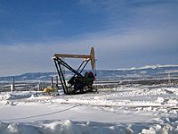
Energy generation

Petroleum
Natural gas
Natural gas is a naturally occurring gas mixture consisting primarily of methane, typically with 0–20% higher hydrocarbons . It is found associated with other hydrocarbon fuel, in coal beds, as methane clathrates, and is an important fuel source and a major feedstock for fertilizers.Most natural...
. Major petroleum deposits are present in the San Juan Basin
San Juan Basin
The San Juan Basin is a geologic structural basin in the Four Corners region of the Southwestern United States; its main portion covers around , encompassing much of northwestern New Mexico, southwest Colorado, and parts of Arizona and Utah....
of New Mexico
New Mexico
New Mexico is a state located in the southwest and western regions of the United States. New Mexico is also usually considered one of the Mountain States. With a population density of 16 per square mile, New Mexico is the sixth-most sparsely inhabited U.S...
and Colorado
Colorado
Colorado is a U.S. state that encompasses much of the Rocky Mountains as well as the northeastern portion of the Colorado Plateau and the western edge of the Great Plains...
, the Uinta Basin of Utah
Utah
Utah is a state in the Western United States. It was the 45th state to join the Union, on January 4, 1896. Approximately 80% of Utah's 2,763,885 people live along the Wasatch Front, centering on Salt Lake City. This leaves vast expanses of the state nearly uninhabited, making the population the...
, the Piceance Basin
Piceance Basin
The Piceance Basin is a geologic structural basin in northwestern Colorado, in the United States. It includes geologic formations from Cambrian to Holocene in age, but the thickest section is made up of rocks from the Cretaceous Period...
of Colorado
Colorado
Colorado is a U.S. state that encompasses much of the Rocky Mountains as well as the northeastern portion of the Colorado Plateau and the western edge of the Great Plains...
, and the Paradox Basin
Paradox Basin
The Paradox Basin is an asymmetric foreland basin located mostly in southeast Utah and southwest Colorado, but extending into northeast Arizona and northwest New Mexico. The basin is a large elongate northwest to southeast oriented depression formed during the late Paleozoic Era...
of Utah
Utah
Utah is a state in the Western United States. It was the 45th state to join the Union, on January 4, 1896. Approximately 80% of Utah's 2,763,885 people live along the Wasatch Front, centering on Salt Lake City. This leaves vast expanses of the state nearly uninhabited, making the population the...
, Colorado
Colorado
Colorado is a U.S. state that encompasses much of the Rocky Mountains as well as the northeastern portion of the Colorado Plateau and the western edge of the Great Plains...
, and Arizona
Arizona
Arizona ; is a state located in the southwestern region of the United States. It is also part of the western United States and the mountain west. The capital and largest city is Phoenix...
.
Uranium
The Colorado Plateau holds major uranium deposits, and there was a Uranium boom in the 1950s. (See Uranium mining in UtahUranium mining in Utah
Uranium mining in Utah, a state of the United States, has a history going back more than 100 years. Uranium started as a byproduct of vanadium mining about 1900, became a byproduct of radium mining about 1910, then back to a byproduct of vanadium when the radium price fell in the 1920s. Utah saw...
and Uranium mining in the United States
Uranium mining in the United States
Uranium mining in the United States is the extraction of uranium-bearing ore from the earth. While uranium is used primarily for nuclear power, uranium mining had its roots in the production of uranium-bearing ore in 1898 with the mining of carnotite-bearing sandstones of the Colorado Plateau in...
). The Atlas Uranium Mill near Moab has left a problematic tailings pile for cleanup.
Coal
Major coal deposits are being mined in the Colorado Plateau in UtahUtah
Utah is a state in the Western United States. It was the 45th state to join the Union, on January 4, 1896. Approximately 80% of Utah's 2,763,885 people live along the Wasatch Front, centering on Salt Lake City. This leaves vast expanses of the state nearly uninhabited, making the population the...
, Arizona
Arizona
Arizona ; is a state located in the southwestern region of the United States. It is also part of the western United States and the mountain west. The capital and largest city is Phoenix...
, Colorado
Colorado
Colorado is a U.S. state that encompasses much of the Rocky Mountains as well as the northeastern portion of the Colorado Plateau and the western edge of the Great Plains...
, and New Mexico
New Mexico
New Mexico is a state located in the southwest and western regions of the United States. New Mexico is also usually considered one of the Mountain States. With a population density of 16 per square mile, New Mexico is the sixth-most sparsely inhabited U.S...
, though large coal mining projects, such as on the Kaiparowits Plateau
Kaiparowits Plateau
right|Location of the Kaiparowits Plateau within UtahThe Kaiparowits Plateau is a large, elevated landform located in southern Utah, in the southwestern United States. Along with the Grand Staircase and the Canyons of the Escalante, it makes up a significant portion of the Grand...
, have been proposed and defeated politically. The ITT Power Project, eventually located in Lynndyl, Utah
Lynndyl, Utah
Lynndyl is a town in Millard County, Utah, United States. The population was 134 at the 2000 census.-Geography:Lynndyl is located at ....
, near Delta, was originally suggested for Salt Wash near Capitol Reef National Park. After a firestorm of opposition, it was moved to a less beloved site. In Utah the largest deposits are in aptly named Carbon County. In Arizona the biggest operation is on Black Mesa, supplying coal to Navajo Power Plant.
Gilsonite and uintatite
Perhaps the only one of its kind, a gilsoniteGilsonite
Gilsonite is the registered trademark for a form of natural asphalt found only in the Uintah Basin of Utah; the non-trademarked mineral name is uintaite or uintahite. It is mined in underground shafts and resembles shiny black obsidian...
plant near Bonanza, southeast of Vernal, Utah
Vernal, Utah
Vernal, Uintah County's largest city, is located in eastern Utah near the Colorado State Line, and 175 miles east of Salt Lake City. It is bordered on the north by the Uinta Mountains, one of the few mountains ranges in the world which lie in an east-west rather than the usual north to south...
, mines this unique, lustrous, brittle form of asphalt, for use in "varnishes, paints,...ink, waterproofing compounds, electrical insulation,...roofing materials."
Oil shale
Huge deposits of oil shaleOil shale
Oil shale, an organic-rich fine-grained sedimentary rock, contains significant amounts of kerogen from which liquid hydrocarbons called shale oil can be produced...
, primarily in the northeastern Colorado Plateau, lie waiting for improved technology to tap their riches.
Scenic beauty
The scenic appeal of this unique landscape had become, well before the end of the twentieth century, its greatest financial natural resource. The amount of commercial benefit to the four states of the Colorado Plateau from tourism exceeded that of any other natural resource.Protected lands

Arroyo (creek)
An arroyo , a Spanish word translated as brook, and also called a wash is usually a dry creek or stream bed—gulch that temporarily or seasonally fills and flows after sufficient rain. Wadi is a similar term in Africa. In Spain, a rambla has a similar meaning to arroyo.-Types and processes:Arroyos...
s, canyon
Canyon
A canyon or gorge is a deep ravine between cliffs often carved from the landscape by a river. Rivers have a natural tendency to reach a baseline elevation, which is the same elevation as the body of water it will eventually drain into. This forms a canyon. Most canyons were formed by a process of...
s, cliff
Cliff
In geography and geology, a cliff is a significant vertical, or near vertical, rock exposure. Cliffs are formed as erosion landforms due to the processes of erosion and weathering that produce them. Cliffs are common on coasts, in mountainous areas, escarpments and along rivers. Cliffs are usually...
s, fins, natural bridge
Natural arch
A natural arch or natural bridge is a natural geological formation where a rock arch forms, with an opening underneath. Most natural arches form as a narrow ridge, walled by cliffs, become narrower from erosion, with a softer rock stratum under the cliff-forming stratum gradually eroding out until...
s, pinnacles, hoodoo
Hoodoo (geology)
A hoodoo is a tall, thin spire of rock that protrudes from the bottom of an arid drainage basin or badland. Hoodoos consist of relatively soft rock topped by harder, less easily eroded stone that protects each column from the elements...
s, and monolith
Monolith
A monolith is a geological feature such as a mountain, consisting of a single massive stone or rock, or a single piece of rock placed as, or within, a monument...
s that, in various places and extents, have been protected. Also protected are areas of historic or cultural significance, such as the pueblo
Pueblo
Pueblo is a term used to describe modern communities of Native Americans in the Southwestern United States of America. The first Spanish explorers of the Southwest used this term to describe the communities housed in apartment-like structures built of stone, adobe mud, and other local material...
s of the Anasazi culture. There are nine U.S. National Parks, a National Historical Park, sixteen U.S. National Monument
U.S. National Monument
A National Monument in the United States is a protected area that is similar to a National Park except that the President of the United States can quickly declare an area of the United States to be a National Monument without the approval of Congress. National monuments receive less funding and...
s and dozens of wilderness areas in the province along with millions of acres in U.S. National Forests, many state parks, and other protected lands. In fact, this region has the highest concentration of parklands in North America
North America
North America is a continent wholly within the Northern Hemisphere and almost wholly within the Western Hemisphere. It is also considered a northern subcontinent of the Americas...
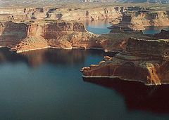
. Lake Powell
Lake Powell
Lake Powell is a huge reservoir on the Colorado River, straddling the border between Utah and Arizona . It is the second largest man-made reservoir in the United States behind Lake Mead, storing of water when full...
, in foreground, is not a natural lake but a reservoir impounded by Glen Canyon Dam
Glen Canyon Dam
Glen Canyon Dam is a concrete arch dam on the Colorado River in northern Arizona in the United States, just north of Page. The dam was built to provide hydroelectricity and flow regulation from the upper Colorado River Basin to the lower. Its reservoir is called Lake Powell, and is the second...
.
National parks (from south to north to south clockwise):
- Petrified Forest National ParkPetrified Forest National ParkPetrified Forest National Park is a United States national park in Navajo and Apache counties in northeastern Arizona. The park's headquarters are about east of Holbrook along Interstate 40 , which parallels a railroad line, the Puerco River, and historic U.S. Route 66, all crossing the park...
- Grand Canyon National ParkGrand Canyon National ParkGrand Canyon National Park is the United States' 15th oldest national park and is located in Arizona. Within the park lies the Grand Canyon, a gorge of the Colorado River, considered to be one of the Wonders of the World. The park covers of unincorporated area in Coconino and Mohave counties.Most...
- Zion National ParkZion National ParkZion National Park is located in the Southwestern United States, near Springdale, Utah. A prominent feature of the park is Zion Canyon, which is 15 miles long and up to half a mile deep, cut through the reddish and tan-colored Navajo Sandstone by the North Fork of the Virgin River...
- Bryce Canyon National ParkBryce Canyon National ParkBryce Canyon National Park is a national park located in southwestern Utah in the United States. The major feature of the park is Bryce Canyon which, despite its name, is not a canyon but a giant natural amphitheater created by erosion along the eastern side of the Paunsaugunt Plateau...
- Capitol Reef National ParkCapitol Reef National ParkCapitol Reef National Park is a United States National Park, in south-central Utah. It is 100 miles long but fairly narrow. The park, established in 1971, preserves 378 mi² and is open all year, although May through September are the most popular months.Called "Wayne Wonderland" in the 1920s...
- Canyonlands National ParkCanyonlands National ParkCanyonlands National Park is a U.S. National Park located in southeastern Utah near the town of Moab and preserves a colorful landscape eroded into countless canyons, mesas and buttes by the Colorado River, the Green River, and their respective tributaries. The park is divided into four districts:...
- Arches National ParkArches National ParkArches National Park is a U.S. National Park in eastern Utah. It is known for preserving over 2000 natural sandstone arches, including the world-famous Delicate Arch, in addition to a variety of unique geological resources and formations....
- Black Canyon of the Gunnison National ParkBlack Canyon of the Gunnison National Parkthumb|upright|Black Canyon of the GunnisonBlack Canyon of the Gunnison National Park is a United States National Park located in western Colorado, and managed by the National Park Service...
- Mesa Verde National ParkMesa Verde National ParkMesa Verde National Park is a U.S. National Park and UNESCO World Heritage Site located in Montezuma County, Colorado, United States. It was created in 1906 to protect some of the best-preserved cliff dwellings in the world...
- Chaco Culture National Historical ParkChaco Culture National Historical ParkChaco Culture National Historical Park is a United States National Historical Park hosting the densest and most exceptional concentration of pueblos in the American Southwest. The park is located in northwestern New Mexico, between Albuquerque and Farmington, in a remote canyon cut by the Chaco Wash...
National Monuments (alphabetical):
- Aztec Ruins National MonumentAztec Ruins National MonumentThe Aztec Ruins National Monument preserves ancestral Pueblo structures in north-western New Mexico, United States, located close to the town of Aztec and northeast of Farmington, near the Animas River...
- Canyon De Chelly National MonumentCanyon de Chelly National MonumentCanyon de Chelly National Monument was established on April 1, 1931 as a unit of the National Park Service. It is located in northeastern Arizona within the boundaries of the Navajo Nation...
- Canyons of the Ancients National MonumentCanyons of the Ancients National MonumentCanyons of the Ancients National Monument is located in the southwestern region of the U.S. state of Colorado, and is managed by the U.S. Bureau of Land Management, an agency within the U.S. Department of the Interior...
- Cedar Breaks National MonumentCedar Breaks National MonumentCedar Breaks National Monument is a U.S. National Monument located in the U.S. state of Utah near Cedar City. Cedar Breaks is a natural amphitheater canyon, stretching across , with a depth of over . The elevation of the rim of the canyon is over above sea level.The eroded rock of the canyon is...
- Colorado National MonumentColorado National Monument- Trails :The Monument contains many hiking trails, with lengths and difficulties to suit all tastes. Summer storms can cause flash floods as well as dangerous trail conditions. Rattlesnakes are found on the Monument, and rough terrain exists everywhere, but most trails are well-maintained...
- Grand Canyon-Parashant National MonumentGrand Canyon-Parashant National MonumentGrand Canyon-Parashant National Monument is located on the northern edge of the Grand Canyon in northwest Arizona. It was established by Presidential Proclamation 7265 on January 11, 2000...
- Grand Staircase-Escalante National MonumentGrand Staircase-Escalante National MonumentThe Grand Staircase-Escalante National Monument contains 1.9 million acres of land in southern Utah, the United States. There are three main regions: the Grand Staircase, the Kaiparowits Plateau, and the Canyons of the Escalante. President Bill Clinton designated the area as a U.S. National...
- El Malpais National MonumentEl Malpais National MonumentEl Malpais National Monument is a National Monument located in western New Mexico, in the Southwestern United States. The name El Malpais is from the Spanish term Malpaís, meaning badlands, due to the extremely barren and dramatic volcanic field that covers much of the park's area.-Geography:The El...
- El Morro National MonumentEl Morro National MonumentEl Morro National Monument is located on an ancient east-west trail in western New Mexico. The main feature of this National Monument is a great sandstone promontory with a pool of water at its base. As a shaded oasis in the western U.S. desert, this site has seen many centuries of travelers...
- Hovenweep National MonumentHovenweep National MonumentHovenweep National Monument is located on land in southwestern Colorado and southeastern Utah, located between Cortez, Colorado and Blanding, Utah on the Cajon Mesa of the Great Sage Plain...
- Navajo National MonumentNavajo National MonumentNavajo National Monument is located within the northwest portion of the Navajo Reservation in northern Arizona.Navajo National Monument preserves three of the most intact cliff dwellings of the ancestral puebloan people . The Navajo people who live here today call these ancient ones Anasazi...
- Natural Bridges National MonumentNatural Bridges National MonumentNatural Bridges National Monument is a U.S. National Monument located about north west of the Four Corners boundary of southeast Utah, in the western United States, at the junction of White Canyon and Armstrong Canyon, part of the Colorado River drainage...
- Rainbow Bridge National MonumentRainbow Bridge National MonumentRainbow Bridge National Monument is administered by Glen Canyon National Recreation Area, southern Utah, USA. Rainbow Bridge is often described as the world's highest natural bridge. The span of Rainbow Bridge was reported in 1974 by the Bureau of Reclamation to be , but a laser measurement in...
- Sunset Crater National Monument
- Vermilion Cliffs National MonumentVermilion Cliffs National MonumentVermilion Cliffs National Monument is located in Arizona, immediately south of the Utah state line. This National Monument, 294,000 acre in area, protects the Paria Plateau, Vermilion Cliffs, Coyote Buttes, and Paria Canyon...
- Walnut Canyon National MonumentWalnut Canyon National MonumentWalnut Canyon National Monument is a United States National Monument located about southeast of downtown Flagstaff, Arizona, just off Interstate 40. The canyon rim lies at ; the canyon's floor is 350 ft lower...
- Wupatki National MonumentWupatki National MonumentThe Wupatki National Monument is a National Monument located in north-central Arizona, near Flagstaff. Rich in Native American ruins, the monument is administered by the National Park Service in close conjunction with the nearby Sunset Crater Volcano National Monument.Wupatki was listed on the...
Wilderness areas:
|
|
Other notable protected areas include: Glen Canyon National Recreation Area
Glen Canyon National Recreation Area
Glen Canyon National Recreation Area is a recreation and conservation unit of the National Park Service that encompasses the area around Lake Powell and lower Cataract Canyon in Utah and Arizona, covering 1,254,429 acres of mostly desert...
, Dead Horse Point State Park
Dead Horse Point State Park
Dead Horse Point State Park is a state park of Utah, USA, featuring a dramatic overlook of the Colorado River and Canyonlands National Park. The park is so named because of its use as a natural corral by cowboys in the 19th century...
, Goosenecks State Park
Goosenecks State Park
Goosenecks State Park is a state park of Utah, USA, overlooking a deep meander of the San Juan River. The park is located near the southern border of the state a short distance from Mexican Hat, Utah. Millions of years ago, the Monument Upwarp forced the river to carve incised meanders over deep...
, the San Rafael Swell
San Rafael Swell
The San Rafael Swell is a large geologic feature located in south-central Utah, USA about 30 miles west of Green River, Utah. The San Rafael Swell, approximately by , consists of a giant dome-shaped anticline of sandstone, shale, and limestone that was pushed up during the Paleocene Laramide...
, the Grand Gulch Primitive Area, Kodachrome Basin State Park
Kodachrome Basin State Park
Kodachrome Basin is a state park of Utah, USA. It is situated above sea level, south of Utah Route 12, and southeast of Bryce Canyon National Park. It is accessible from the north from Cannonville by a paved road and from the south by Road 400, a dirt road from the Page, Arizona area to...
, Goblin Valley State Park
Goblin Valley State Park
Goblin Valley State Park is a state park of Utah, USA.Its eminent feature is its thousands of hoodoos and hoodoo rocks, which are formations of mushroom-shaped rock pinnacles, some as high as several meters...
and Barringer Crater.
Sedona, Arizona and Oak Creek Canyon lie on the south-central border of the Plateau. Many but not all of the Sedona area's cliff formations are protected as wilderness. The area has the visual appeal of a national park, but with a small, rapidly growing town in the center.
See also
- DesertsDésertsDéserts is a piece by Edgard Varèse for brass , percussion , piano, and tape. Percussion instruments are exploited for their resonant potential, rather than used solely as accompaniment...
- Rocky MountainsRocky MountainsThe Rocky Mountains are a major mountain range in western North America. The Rocky Mountains stretch more than from the northernmost part of British Columbia, in western Canada, to New Mexico, in the southwestern United States...
- Mojave DesertMojave DesertThe Mojave Desert occupies a significant portion of southeastern California and smaller parts of central California, southern Nevada, southwestern Utah and northwestern Arizona, in the United States...
- Great BasinGreat BasinThe Great Basin is the largest area of contiguous endorheic watersheds in North America and is noted for its arid conditions and Basin and Range topography that varies from the North American low point at Badwater Basin to the highest point of the contiguous United States, less than away at the...
- Sonoran DesertSonoran DesertThe Sonoran Desert is a North American desert which straddles part of the United States-Mexico border and covers large parts of the U.S. states of Arizona and California and the northwest Mexican states of Sonora, Baja California, and Baja California Sur. It is one of the largest and hottest...
Further reading
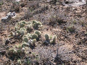
- Donald L. Baars, Red Rock Country: The Geologic History of the Colorado Plateau, Doubleday (1972), hardcover, ISBN 0-385-01341-8
- Donald L. Baars, Traveler's Guide to the Geology of the Colorado Plateau, University of Utah Press (2002), trade paperback, 250 pages, ISBN 0-87480-715-8
- W. Scott Baldridge, Geology of the American Southwest: A Journey Through Two Billion Years of Plate-Tectonic History, Cambridge University Press (2004), 280 pages, ISBN 0-521-01666-5
- Crampton, C. Gregory, Standing Up Country: The Canyon Lands of Utah and Arizona, Rio Nuevo Publishers (September 2000), ISBN 1-887896-15-5
- Fillmore, Robert. Geological Evolution of the Colorado Plateau of Eastern Utah and Western Colorado. University of Utah Press (2011). ISBN 978-1-60781-004-9
- Geology of National Parks: Fifth Edition, Ann G. Harris, Esther Tuttle, Sherwood D., Tuttle (Iowa, Kendall/Hunt Publishing; 1997), pages 2–3, 19-20, 25 ISBN 0-7872-5353-7
- Physical Geology: Eight Edition, Plummer, McGeary, Carlson, (McGraw-Hill: Boston; 1999), page 320 ISBN 0-697-37404-1
- Earth System History, Steven M. Stanley, (W.H. Freeman and Company; 1999), pages 511-513, 537 ISBN 0-7167-2882-6
- USGS - Geologic Provinces of the United States: Colorado Plateau Province (some adapted public domain text)
- Annabelle Foos, Geology of the Colorado Plateau, National Park Service PDF Accessed 12/21/2005.
- Ward Roylance, Utah: A Guide to the State, Utah: A Guide to the State Foundation; Salt Lake City; 1982; 779 pp
- Look, Al, 1947, A Thousand Million Years on the Colorado Plateau, Golden Bell Publications, Fifth printing 1971, 300 pages.
- The Bright Edge, Subtitle: Guide to the National Parks of the Colorado Plateau.