
Mount St. Helens National Volcanic Monument
Encyclopedia
Mount St. Helens National Volcanic Monument is a U.S. National Monument
U.S. National Monument
A National Monument in the United States is a protected area that is similar to a National Park except that the President of the United States can quickly declare an area of the United States to be a National Monument without the approval of Congress. National monuments receive less funding and...
that includes the area around Mount St. Helens
Mount St. Helens
Mount St. Helens is an active stratovolcano located in Skamania County, Washington, in the Pacific Northwest region of the United States. It is south of Seattle, Washington and northeast of Portland, Oregon. Mount St. Helens takes its English name from the British diplomat Lord St Helens, a...
in Washington. It was established on August 27, 1982 by U.S. President Ronald Reagan
Ronald Reagan
Ronald Wilson Reagan was the 40th President of the United States , the 33rd Governor of California and, prior to that, a radio, film and television actor....
following the 1980 eruption of Mount St. Helens
1980 eruption of Mount St. Helens
The 1980 eruption of Mount St. Helens, a stratovolcano located in Washington state, in the United States, was a major volcanic eruption. The eruption was the only significant one to occur in the contiguous 48 U.S. states since the 1915 eruption of Lassen Peak in California...
. The 110,000 acre (445 km2) National Volcanic Monument was set-aside for research, recreation, and education. Inside the Monument, the environment is left to respond naturally to the disturbance.
Mount St. Helens National Volcanic Monument was the United States
United States
The United States of America is a federal constitutional republic comprising fifty states and a federal district...
' first such monument managed by the United States Forest Service
United States Forest Service
The United States Forest Service is an agency of the United States Department of Agriculture that administers the nation's 155 national forests and 20 national grasslands, which encompass...
. At dedication ceremonies on May 18, 1983, Max Peterson, head of the USFS, said,"we can take pride in having preserved the unique episode of natural history for future generations." Since then, many trails, viewpoints, information stations, campgrounds, and picnic areas have been established to accommodate the increasing number of visitors each year.
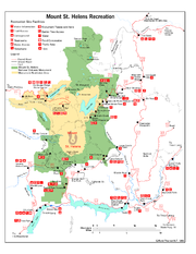
Mountain climbing to the summit of the volcano has been allowed since 1986.
Mount St. Helens Visitor Center at Silver Lake
A visitor center was completed in December 1986 at Silver LakeSilver Lake (Washington)
Silver Lake, in Washington, United States, is both a marsh and unincorporated area located about west of Mount St. Helens. It is home to a nature trail, and the visitor center for the Mount St. Helens National Monument. The lake itself is in size and camping is available at Seaquest State Park,...
, about 30 miles (48.3 km) west of Mount St. Helens and five miles (8 km) east of Interstate Highway 5. By the end of 1989, the Center had hosted more than 1.5 million visitors.
The Mount St. Helens Visitor Center at Silver Lake opened in 1987, and is now operated by the Washington State Park System
Washington State Park System
The Washington State Park System is a set of state parks owned by the state government of Washington, USA. They are managed by the Washington State Parks and Recreation Commission. As of 2011, the parks are primarily funded through the state's general fund, augmented by usage fees...
. Exhibits include the area's culture and history, and the natural history and geology of the volcano and the eruption, including the recovery of the area's vegetation and animal life. The Center includes a theater, a gift shop and outdoor trails. A small admission fee is charged.
The Center was formerly operated by the U.S. Forest Service, and due to its location near Seaquest State Park
Seaquest State Park
Seaquest State Park in Cowlitz County, Washington is a camping park in the Washington State Park System. It consists of of forest with over of freshwater shoreline on Silver Lake near Mount St. Helens. Available activities include hiking , birdwatching, and horseshoes, as well as the Mount St....
, it is also known as Mount St. Helens Visitor Center at Seaquest State Park.
Forest Learning Center
The Forest Learning Center is located inside the blast zone of Mount St. Helens on Highway 504. The center is operated as a partnership between Weyerhaeuser Company, Washington State Department of TransportationWashington State Department of Transportation
The Washington State Department of Transportation , was established in 1905. The agency, led by a Secretary and overseen by the Governor, is a Washington governmental agency that constructs, maintains, and regulates the use of the state's transportation infrastructure...
and the Rocky Mountain Elk Foundation
Rocky Mountain Elk Foundation
The Rocky Mountain Elk Foundation is a conservationist organization, founded in the United States in 1984 by four hunters from Troy, Montana with the mission of ensuring the future of elk, other wildlife, and their habitat...
. Exhibits focus on the geology and natural history of the park and forests, including forest
Forest
A forest, also referred to as a wood or the woods, is an area with a high density of trees. As with cities, depending where you are in the world, what is considered a forest may vary significantly in size and have various classification according to how and what of the forest is composed...
recovery, reforestation and conservation of forest resources.
The center is open to the public from May to October, and admission is free.
Johnston Ridge Observatory
The Johnston Ridge Observatory is located 52 miles (83.7 km) east of Castle Rock, WashingtonCastle Rock, Washington
Castle Rock is a city in Cowlitz County, Washington, United States. Nestled between the Willapa Hills and western base of Mount St. Helens, Castle Rock is at the heart of Washington timber country in the Pacific temperate rain forest...
, at the end of Washington State Route 504. Exhibits focus on the geologic history of the volcano, eyewitness accounts of the explosion, and the science of monitoring volcanic activity. A movie is available and a bookstore. A half-mile trail provides views of the lava
Lava
Lava refers both to molten rock expelled by a volcano during an eruption and the resulting rock after solidification and cooling. This molten rock is formed in the interior of some planets, including Earth, and some of their satellites. When first erupted from a volcanic vent, lava is a liquid at...
dome, crater
Volcanic crater
A volcanic crater is a circular depression in the ground caused by volcanic activity. It is typically a basin, circular in form within which occurs a vent from which magma erupts as gases, lava, and ejecta. A crater can be of large dimensions, and sometimes of great depth...
, pumice
Pumice
Pumice is a textural term for a volcanic rock that is a solidified frothy lava typically created when super-heated, highly pressurized rock is violently ejected from a volcano. It can be formed when lava and water are mixed. This unusual formation is due to the simultaneous actions of rapid...
plain, and landslide deposit.
The observatory is located by the site of volcanologist
Volcanologist
A volcanologist is a person who studies the formation of volcanoes, and their current and historic eruptions. Volcanologists frequently visit volcanoes, especially active ones, to observe volcanic eruptions, collect eruptive products including tephra , rock and lava samples...
David A. Johnston
David A. Johnston
David Alexander Johnston was an American volcanologist with the United States Geological Survey who was killed by the 1980 eruption of Mount St. Helens in Washington. One of the principal scientists on the monitoring team, Johnston died while manning an observation post about 6 miles from the...
's camp on the morning of May 18, 1980, and opened in 1997.
Coldwater Ridge Visitor Center
Opening in 1993 was an interpretation complex in the Coldwater Lake area. The visitor center closed permanently in November 2007. In August 2010, funding to replace the windows at the closed center topped a list of wasteful stimulus spending examples in a report released by Senators Tom CoburnTom Coburn
Thomas Allen "Tom" Coburn, M.D. , is an American politician, medical doctor, and Southern Baptist deacon. A member of the Republican Party, he currently serves as the junior U.S. Senator from Oklahoma. In the Senate, he is known as "Dr. No" for his tendency to place holds on and vote against bills...
and John McCain
John McCain
John Sidney McCain III is the senior United States Senator from Arizona. He was the Republican nominee for president in the 2008 United States election....
.
South and East sides of Mount St. Helens
The southern and eastern sides of Mount St. Helens are accessible only by Forest Service roads. The main roads are:-
 Forest Service Road 25 - Monument entrance from U.S. Route 12 to Road 90.
 - Forest Service Road 26 - Road 99 to Norway Pass to Road 25.
- Forest Service Road 81 - SR 503/Road 90 to Merrill Lake, Kalama Horse Camp, and Climber's Bivouac.
- Forest Service Road 83 - Road 90 to Ape Cave, Ape Canyon, Lava Canyon lahar, and Smith Creek.
- Forest Service Road 90 - Monument entrance from State Route 503Washington State Route 503State Route 503, also known as the St. Helens South Roadway, is a state route through the state of Washington. It has a spur route, State Route 503 Spur. It has a Southern terminus at State Route 500 and a Northern terminus at Interstate 5....
. - Forest Service Road 99 - Road 25 to Bear Meadows, Meta Lake and Miner's Car, and Windy Ridge.
Bear Meadows
Bear Meadows is an alpine meadow and viewpoint northeast of Mt. St. Helens. It is located on Forest Service Road 99. Gary Rosenquist camped here with friends on May 17–18, 1980. He started taking his famous eruption photographs from this location. The sequence of eruption photos show give a time lapse view of the developing eruption. As the lateral blast developed, he and his friends abandoned their campsite fearing for their lives. He continued taking photos as they escaped in a car. The eruption's lateral blast narrowly missed the site as it was deflected by a ridge just west of the meadow. In an interview with KIRO-TVKIRO-TV
KIRO-TV, virtual channel 7, is the CBS affiliate television station in Seattle, Washington. It broadcasts on digital channel 39. The station's offices and broadcasting center are located near Seattle Center in Belltown, and its transmitter is located on Queen Anne Hill...
in 1990, a friend called that ridge "the line of death."
Windy Ridge
Windy Ridge is the closest view point accessible to the general public. Beginning in the summer of 1983, visitors have been able to drive to Windy Ridge, on Forest Service Road 99, only 4 miles (6.4 km) northeast of the crater. From this vantage point overlooking Spirit LakeSpirit Lake (Washington)
Spirit Lake is a lake north of Mount St. Helens in Washington State. The lake was a popular tourist destination for many years until the 1980 eruption of Mount St. Helens. With the eruption and resulting megatsunami, thousands of trees were torn from the surrounding hillside after lake water was...
, people see firsthand not only the evidence of a volcano's destruction, but also the remarkable, gradual (but faster than originally predicted) recovery of the land as revegetation proceeds and wildlife returns.
External links
- Mount St. Helens National Volcanic Monument - official U.S. Forest Service site
- Mount St. Helens Visitor Center at Silver Lake - official Washington State Parks site
- Mount St. Helens National Volcanic Monument - Visit a Volcano, includes maps and volcano information
- Travel information about Mount St. Helens National Volcanic Monument
- Forest Learning Center
- Johnston Ridge Observatory