
Walnut Canyon National Monument
Encyclopedia
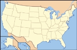
Walnut Canyon National Monument is a United States National Monument located about 10 mi (16.1 km) southeast of downtown Flagstaff, Arizona
, just off Interstate 40
. The canyon
rim lies at 6690 ft (2,039.1 m); the canyon's floor is 350 ft lower. A 0.9 mi (1.4 km) long loop trail descends 185 ft (56.4 m) into the canyon passing 25 cliff dwelling rooms constructed by the Sinagua
, a pre-Columbian cultural group that lived in Walnut Canyon from about 1100 to 1250 CE. " Other contemporary habitations of the Sinagua people are preserved in the nearby Tuzigoot
and Montezuma Castle
national monuments.
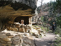
 Sinagua is Spanish for "without-water", an acknowledgement that the Sinagua people were able to live in a such a dry region. By living in such a region the Sinagua became experts at conserving water and dealing with droughts. The Sinagua, who inhabitanted the dwellings in Walnut Canyon, left mysteriously around 1250 CE. It is thought that the Sinagua left because of fear of neighboring tribes or droughts, but it is not certain. The disappearance of the Sinagua left over 80 cliff dwellings behind. The dwellings themselves were small but large enough for the inhabitants to still be able to cook and sleep. Most of the cliff dwelling rooms are situated near the loop trail, typically slightly above the trail and immediately outside the loop itself. A typical room might have been the dwelling of a single family, and might measure approximately two meters high by six meters long by three meters deep. Because of the area's dry climate, the water present in the canyon was essential for its inhabitants over 700 years ago as it is for the animal and plant life that exists there today. The plant life is very diverse in Walnut Canyon, with more than 387 different plant species, including the Prickly Pear cactus and the Arizona black walnut. The biodiversity of the area includes high concentrations of sensitive plant species that probably contributed to the decision made by prehistoric people to settle in the area.
There are other ruins in the 20 by 10 mile area but none are accessible to the public. Many more dwellings to be seen up close in the canyon just east of the Monument, although it is illegal to actually enter the canyon because of the park's rules and regulations.
Walnut Canyon was proclaimed a national monument on November 30, 1915 by President Woodrow Wilson in order to preserve the ancient cliff dwellings. It was transferred from the USDA Forest Service
to the National Park Service
on August 10, 1933. As with all historic areas administered by the National Park Service, the national monument was listed on the National Register of Historic Places
on October 15, 1966. At Walnut Canyon, there are trails for tourists to get a close view of the dwellings.
 Walnut Canyon lies on the Colorado Plateau
and cuts through the Permian
Kaibab Limestone
, which exposes the Toroweap Formation and Coconino Sandstone
. The Kaibab formation also forms the rim of the Grand Canyon
. Crossbedding is present in the Coconino Sandstone.
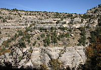
The Walnut Canyon site contains Walnut Creek, which carved a 600 foot deep canyon that flows east. The creek joins into the Little Colorado River on its way to the Grand Canyon. The creek has also created a varied and abundant array of vegetation. The shaded, north- facing walls are covered in fir and ponderosa pine trees. The sunny, south facing slopes have agaves and several species of cactus including opuntia, echnocereus and cholla. The floor of the canyon is home to several species of walnut trees, for which the canyon is named.
The rocks in the canyon walls are formed of three distinct layers - the upper third of Walnut Canyon's walls contain Kaibab limestone that varies in layers and hardness, where the cliff dwellings are found, which overlies steep, scrub covered slopes of the Toroweap Formation, while the lowest third is the sheer-walled, cross-bedded Coconino sandstone. Many layers of the limestone eroded, creating alcoves that the Sinagua Indians used as cave-dwellings.
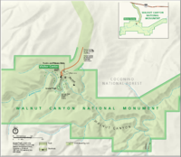
Today a variety of archeological and natural resources are preserved on approximately 3600 acres.
The Walnut Canyon site is near Flagstaff. It is 7 miles east of I-40 and 3 miles south of exit 204. The park has a museum and a small visitor center that sits on top of a cliff. Many of the ancient dwellings were built around a U-shaped meander in the canyon, where the creek circles around three sides of a high rocky plateau, almost creating an 'island', and this region now forms the central attraction of the national monument. There are other ruins in the surround area which are not open to the public. Other dwellings of the Sinagua people can be found in the nearby Tuzigoot and Montezuma Castle monuments.
Flagstaff, Arizona
Flagstaff is a city located in northern Arizona, in the southwestern United States. In 2010, the city's population was 65,870. The population of the Metropolitan Statistical Area was at 134,421 in 2010. It is the county seat of Coconino County...
, just off Interstate 40
Interstate 40
Interstate 40 is the third-longest major east–west Interstate Highway in the United States, after I-90 and I-80. Its western end is at Interstate 15 in Barstow, California; its eastern end is at a concurrency of U.S. Route 117 and North Carolina Highway 132 in Wilmington, North Carolina...
. The canyon
Canyon
A canyon or gorge is a deep ravine between cliffs often carved from the landscape by a river. Rivers have a natural tendency to reach a baseline elevation, which is the same elevation as the body of water it will eventually drain into. This forms a canyon. Most canyons were formed by a process of...
rim lies at 6690 ft (2,039.1 m); the canyon's floor is 350 ft lower. A 0.9 mi (1.4 km) long loop trail descends 185 ft (56.4 m) into the canyon passing 25 cliff dwelling rooms constructed by the Sinagua
Sinagua
The Sinagua were a pre-Columbian cultural group occupying an area in central Arizona between the Little Colorado River and the Salt River including the Verde Valley and significant portions of the Mogollon Rim country between approximately 500 AD and 1425 AD.Early Sinagua sites consist of pit houses...
, a pre-Columbian cultural group that lived in Walnut Canyon from about 1100 to 1250 CE. " Other contemporary habitations of the Sinagua people are preserved in the nearby Tuzigoot
Tuzigoot National Monument
Tuzigoot National Monument preserves a 2 to 3 story pueblo ruin on the summit of a limestone and sandstone ridge just east of Clarkdale, Arizona, 120 feet above the Verde River floodplain. The pueblo has 110 rooms...
and Montezuma Castle
Montezuma Castle National Monument
Montezuma Castle National Monument, located near Camp Verde, Arizona, in the Southwestern United States, features well-preserved cliff-dwellings. They were built and used by the Pre-Columbian Sinagua people, northern cousins of the Hohokam, around 700 AD. Several Hopi clans trace their roots to...
national monuments.
History
There are other ruins in the 20 by 10 mile area but none are accessible to the public. Many more dwellings to be seen up close in the canyon just east of the Monument, although it is illegal to actually enter the canyon because of the park's rules and regulations.
Walnut Canyon was proclaimed a national monument on November 30, 1915 by President Woodrow Wilson in order to preserve the ancient cliff dwellings. It was transferred from the USDA Forest Service
United States Forest Service
The United States Forest Service is an agency of the United States Department of Agriculture that administers the nation's 155 national forests and 20 national grasslands, which encompass...
to the National Park Service
National Park Service
The National Park Service is the U.S. federal agency that manages all national parks, many national monuments, and other conservation and historical properties with various title designations...
on August 10, 1933. As with all historic areas administered by the National Park Service, the national monument was listed on the National Register of Historic Places
National Register of Historic Places
The National Register of Historic Places is the United States government's official list of districts, sites, buildings, structures, and objects deemed worthy of preservation...
on October 15, 1966. At Walnut Canyon, there are trails for tourists to get a close view of the dwellings.
Geology
Colorado Plateau
The Colorado Plateau, also called the Colorado Plateau Province, is a physiographic region of the Intermontane Plateaus, roughly centered on the Four Corners region of the southwestern United States. The province covers an area of 337,000 km2 within western Colorado, northwestern New Mexico,...
and cuts through the Permian
Permian
The PermianThe term "Permian" was introduced into geology in 1841 by Sir Sir R. I. Murchison, president of the Geological Society of London, who identified typical strata in extensive Russian explorations undertaken with Edouard de Verneuil; Murchison asserted in 1841 that he named his "Permian...
Kaibab Limestone
Kaibab Limestone
The Kaibab is a geologic formation that is spread across the U.S. states of northern Arizona, southern Utah, east central Nevada and southeast California. This geologic unit is part of the Park City Group in Nevada and Utah and is sometimes locally classified as a geologic group in Utah...
, which exposes the Toroweap Formation and Coconino Sandstone
Coconino Sandstone
Coconino Sandstone is a geologic formation named after its exposure in Coconino County, Arizona. This formation spreads across the Colorado Plateau province of the United States, including northern Arizona, northwest Colorado, Nevada, and Utah....
. The Kaibab formation also forms the rim of the Grand Canyon
Grand Canyon
The Grand Canyon is a steep-sided canyon carved by the Colorado River in the United States in the state of Arizona. It is largely contained within the Grand Canyon National Park, the 15th national park in the United States...
. Crossbedding is present in the Coconino Sandstone.
The Walnut Canyon site contains Walnut Creek, which carved a 600 foot deep canyon that flows east. The creek joins into the Little Colorado River on its way to the Grand Canyon. The creek has also created a varied and abundant array of vegetation. The shaded, north- facing walls are covered in fir and ponderosa pine trees. The sunny, south facing slopes have agaves and several species of cactus including opuntia, echnocereus and cholla. The floor of the canyon is home to several species of walnut trees, for which the canyon is named.
The rocks in the canyon walls are formed of three distinct layers - the upper third of Walnut Canyon's walls contain Kaibab limestone that varies in layers and hardness, where the cliff dwellings are found, which overlies steep, scrub covered slopes of the Toroweap Formation, while the lowest third is the sheer-walled, cross-bedded Coconino sandstone. Many layers of the limestone eroded, creating alcoves that the Sinagua Indians used as cave-dwellings.
Today a variety of archeological and natural resources are preserved on approximately 3600 acres.
Climate
Not all of Arizona is warm dry desert. At Walnut Canyon (6690'/2039m above sea level), be prepared for snow in winter, hot sun in summer with afternoon thunderstorms, and, especially in spring, strong gusty winds on the rim and/or in the canyon. Even though the climate was and still is somewhat harsh, the Sinagua Indians that lived there were able to harvest maize, beans and squash.Operating Hours & Seasons
Park entrance road, trails, and Visitor Center are open all year, except December 25. From May till October the monument is open from 8:00 a.m. to 5:00 p.m. MST and is open from 9:00 a.m. to 5:00 p.m. MST the rest of the year. Entry to park trails closes 1 hour before the monument closes.The Walnut Canyon site is near Flagstaff. It is 7 miles east of I-40 and 3 miles south of exit 204. The park has a museum and a small visitor center that sits on top of a cliff. Many of the ancient dwellings were built around a U-shaped meander in the canyon, where the creek circles around three sides of a high rocky plateau, almost creating an 'island', and this region now forms the central attraction of the national monument. There are other ruins in the surround area which are not open to the public. Other dwellings of the Sinagua people can be found in the nearby Tuzigoot and Montezuma Castle monuments.