
Cape Krusenstern National Monument
Encyclopedia
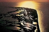
Cape Krusenstern National Monument and the colocated Cape Krusenstern Archeological District is a U.S. National Monument
and a National Historic Landmark
centered on Cape Krusenstern
in northwestern Alaska
.
Founded on December 1, 1978, it is made up mainly of a coastal plain, containing large lagoons and rolling hills of limestone
. The bluffs record thousands of years of change in the shorelines of the Chukchi Sea
, as well as evidence of some 9,000 years of human habitation.
The archeological district comprises 114 ancient beach ridges which formed approximately 60 years apart. They provide a rare sequential look at over 5000 years of inhabitation.
The area in the National Historic Landmark District is vast, making this one of the very largest NHLs in the U.S., along with the Adirondack Park.
U.S. National Monument
A National Monument in the United States is a protected area that is similar to a National Park except that the President of the United States can quickly declare an area of the United States to be a National Monument without the approval of Congress. National monuments receive less funding and...
and a National Historic Landmark
National Historic Landmark
A National Historic Landmark is a building, site, structure, object, or district, that is officially recognized by the United States government for its historical significance...
centered on Cape Krusenstern
Cape Krusenstern
Cape Krusenstern is a cape on the northwestern coast of the U.S. state of Alaska, located near the village of Kivalina at .It is bounded by Kotzebue Sound to the south and the Chukchi Sea to the west, and consists of a series of beach ridges and swales with numerous ponds and lakes...
in northwestern Alaska
Alaska
Alaska is the largest state in the United States by area. It is situated in the northwest extremity of the North American continent, with Canada to the east, the Arctic Ocean to the north, and the Pacific Ocean to the west and south, with Russia further west across the Bering Strait...
.
Founded on December 1, 1978, it is made up mainly of a coastal plain, containing large lagoons and rolling hills of limestone
Limestone
Limestone is a sedimentary rock composed largely of the minerals calcite and aragonite, which are different crystal forms of calcium carbonate . Many limestones are composed from skeletal fragments of marine organisms such as coral or foraminifera....
. The bluffs record thousands of years of change in the shorelines of the Chukchi Sea
Chukchi Sea
Chukchi Sea is a marginal sea of the Arctic Ocean. It is bounded on the west by the De Long Strait, off Wrangel Island, and in the east by Point Barrow, Alaska, beyond which lies the Beaufort Sea. The Bering Strait forms its southernmost limit and connects it to the Bering Sea and the Pacific...
, as well as evidence of some 9,000 years of human habitation.
The archeological district comprises 114 ancient beach ridges which formed approximately 60 years apart. They provide a rare sequential look at over 5000 years of inhabitation.
The area in the National Historic Landmark District is vast, making this one of the very largest NHLs in the U.S., along with the Adirondack Park.