

Craters of the Moon National Monument and Preserve
Encyclopedia
Craters of the Moon National Monument and Preserve is a national monument
and national preserve
located in the Snake River Plain
in central Idaho
, U.S.A. It is along US 20 (concurrent
with US 93 & US 26), between the small cities of Arco
and Carey
, at an average elevation of 5900 feet (1,798.3 m) above sea level. The protected area
's features are volcanic
and represent one of the best preserved flood basalt
areas in the continental United States.
The Monument was established on May 2, 1924. In November 2000, a presidential proclamation by President Clinton
greatly expanded the Monument area. The National Park Service
portions of the expanded Monument were designated as Craters of the Moon National Preserve in August 2002. It lies in parts of Blaine
, Butte
, Lincoln
, Minidoka
, and Power
counties. The area is managed cooperatively by the National Park Service and the Bureau of Land Management
(BLM).
The Monument and Preserve encompass three major lava fields and about 400 square miles (1,036 km²) of sagebrush
steppe grassland
s to cover a total area of 1117 square miles (2,893 km²). All three lava fields lie along the Great Rift of Idaho, with some of the best examples of open rift cracks in the world, including the deepest known on Earth at 800 feet (243.8 m). There are excellent examples of almost every variety of basalt
ic lava as well as tree molds (cavities left by lava-incinerated trees), lava tube
s (a type of cave
), and many other volcanic features.
-aged basaltic lava field in the lower 48 U.S. state
s. The Monument and Preserve contain more than 25 volcanic cones including outstanding examples of spatter cones
. The 60 distinct lava flows that form the Craters of the Moon Lava Field range in age from 15,000 to just 2,000 years. The Kings Bowl and Wapi lava fields, both about 2,200 years old, are part of the National Preserve.
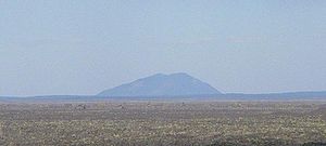
Craters of the Moon Lava Field reaches southeastward from the Pioneer Mountains
. This lava field is the largest of several large beds of lava that erupted from the 53 miles (85.3 km) south-east to north-west trending Great Rift volcanic zone—a line of weakness in the Earth's crust created by Basin and Range
rifting. Together with fields from other fissures they make up the Lava Beds of Idaho, which in turn are located within the much larger Snake River Plain
volcanic province. The Great Rift almost extends across the entire Snake River Plain.
The rugged landscape remains remote and undeveloped with only one paved road across the northern end. Craters of the Moon is located in south-central Idaho midway between Boise
and Yellowstone National Park
, and its elevation at the visitor center is 5900 feet (1,798.3 m) above sea level. Combined U.S. Highway 20-26-93 cuts through the northwestern part of the monument and provides access to it.
Total average precipitation
in the Craters of the Moon area is between 15–20 in (381–508 mm) per year.Lower elevation areas near the Snake River
average only 10–11 inches of precipitation annually. Most of this is lost in cracks in the basalt
, only to emerge later in springs and seeps in the walls of the Snake River Canyon
. Older lava fields on the plain have been invaded by drought
-resistant plants such as sagebrush
, while younger fields, such as Craters of the Moon, only have a seasonal and very sparse cover of vegetation. From a distance this cover disappears almost entirely, giving an impression of utter black desolation. Repeated lava flows over the last 15,000 years have raised the land surface enough to expose it to the prevailing southwesterly winds, which help to keep the area dry. Together these conditions make life on the lava field difficult.
created trails through the Craters of the Moon Lava Field during their summer migrations from the Snake River
to the Camas Prairie
, west of the lava field. Stone windbreaks at Indian Tunnel were used to protect campsites from the dry summer wind. No evidence exists for permanent habitation by any Native American group. A hunting and gathering
culture, the Northern Shoshone pursued Elk
, bear
s, American Bison
, Cougars, and Bighorn Sheep
—all large game who no longer range the area. The most recent volcanic eruptions ended about 2,100 years ago and were likely witnessed by the Shoshone people. Shoshone legend speaks of a serpent on a mountain who, angered by lightning, coiled around and squeezed the mountain until liquid rock flowed, fire shot from cracks, and the mountain exploded.
avoided the lava field area below the Pioneer Mountains by following Indian trails. Early white pioneers who sought gold
, affordable farm land to raise crops, or cheap ranch land to range cattle also avoided the lava fields and considered them useless.
 Pioneers traveling in wagon train
s on the Oregon Trail
in the 1850s and 1860s followed an alternate route in the area that used old Indian trails that skirted the lava flows. This alternate route was later named Goodale's Cutoff
and part of it is located in the northern part of the monument. The cutoff was created to reduce the possibility of ambush by Shoshone warriors along the Snake River
such as the one that occurred at Massacre Rocks, which today is memorialized in Idaho's Massacre Rocks State Park
.
After gold
was discovered in the Salmon River
area of Idaho, a group of emigrants persuaded an Illinois
-born trapper and trader named Tim Goodale to lead them through the cutoff. A large wagon train
left in July 1862 and met up with more wagon
s at Craters of the Moon Lava Field. Numbering 795 men and 300 women and children, the unusually large group was relatively unmolested during its journey and named the cutoff for their guide. Improvements to the cutoff such as adding a ferry to cross the Snake River made it into a popular alternate route of the Oregon Trail.
and watering cattle but found the area to be unsuitable and left.
U.S. Army
Captain and western explorer B.L.E. Bonneville visited the lava fields and other places in the West in the 19th century and wrote about his experiences in his diaries. Washington Irving
later used Bonneville's diaries to write the Adventures of Captain Bonneville, saying this unnamed lava field is a place "where nothing meets the eye but a desolate and awful waste, where no grass grows nor water runs, and where nothing is to be seen but lava."
In 1901 and 1903, Israel Russell
became the first geologist
to study this area while surveying it for the United States Geological Survey
(USGS). In 1910, Samuel Paisley continued Russell's work and later became the monument's first custodian. Others followed and in time much of the mystery surrounding this and the other Lava Beds of Idaho was lifted.
The few whites who visited the area in the 19th century created local legends that it looked like the surface of the Moon
. Geologists Harold T. Stearns coined the name "Craters of the Moon" in 1923 while trying to convince the National Park Service to recommend protection of the area in a national monument.
, explored the area, which he described as "practically unknown and unexplored ..." in the 1920s after hearing stories from fur trappers about "strange things they had seen while ranging the region".
Limbert wrote: "I had made two trips into the northern end, covering practically the same region as that traversed by a Geological Survey party in 1901. My first was a hiking and camping trip with Ad Santel (the wrestler), Dr. Dresser, and Albert Jones; the second was with Wes Watson and Era Martin (ranchers living about four miles [6 km] from the northern edge). The peculiar features seen on those trips led me to take a third across the region in the hope that even more interesting phenomena might be encountered."
Limbert set out on his third and most ambitious foray to the area in May 1920, this time with Walter L. Cole and an Airedale Terrier
to accompany him. Starting from Minidoka
, Idaho
, they explored what is now the monument area from south to north passing Two Point Butte, Echo Crater, Big Craters, North Crater Flow, and out of the lava field through the Yellowstone Park and Lincoln Highway (now known as the Old Arco-Carey Road). Taking the dog along was a mistake, Limbert wrote, "for after three days' travel his feet were worn and bleeding".
A series of newspaper and magazine articles written by Limbert were later published about this and previous treks, which increased public awareness of the area. The most famous of these was an article that appeared in a 1924 issue of National Geographic where he called the area "Craters of the Moon," helping to solidify the use of that name. In the article he had this to say about the cobalt
blue of the Blue Dragon Flows:
to "preserve the unusual and weird volcanic formations". The Craters Inn and several cabins were built in 1927 for the convenience of visitors. The Mission 66 Program initiated construction of today's road system, visitor center, shop, campground and comfort station in 1956 and in 1959 the Craters of the Moon Natural History Association was formed to assist the monument in educational activities. The addition of an island of vegetation completely surrounded by lava known as Carey Kipuka (air photo) increased the size of the monument by 5360 acres (22 km²) in 1962.
Since then the monument has been enlarged. On October 23, 1970, Congress
set aside a large part of it—43243 acres (175 km²)—as Craters of the Moon National Wilderness
, protecting that part under the National Wilderness Preservation System
.
From 1969 to 1972, NASA
visited the real Moon through the Apollo program and found that its surface does not closely resemble this part of Idaho. NASA astronauts discovered that real Moon craters were almost all created by meteorite
s while their namesakes on Earth were created by volcanic eruptions; both are desolate. Apollo astronauts performed part of their training at Craters of the Moon Lava Field by learning to look for and collect good rock
specimens in an unfamiliar and harsh environment.
For many years, geologists, biologists and environmentalists have advocated for expansion of the monument and its transformation into a national park. Part of that goal was reached in 2000 when the monument was expanded 13-fold from 53545 acres (217 km²) to its current size to encompass the entire Great Rift zone and its three lava fields. The entire addition is called the Backcountry Area while the two older parts are called the Developed Area and Wilderness Area. Opposition by cattle interests and hunters to a simple expansion plan led to a compromise of having the addition become a national preserve
in 2002 (which allows hunting, not ordinarily permitted in national parks and monuments in the U.S.). Craters of the Moon National Monument and Preserve is co-managed by the National Park Service
and the Bureau of Land Management
, both under the Department of the Interior
.
is a volcanic province that was created by a series of cataclysmic caldera
-forming super-eruptions
which started about 15 million years ago. A migrating hotspot
thought to now exist under Yellowstone Caldera
in Yellowstone National Park has been implicated. This hot spot was under the Craters of the Moon area some 10 to 11 million years ago but 'moved' as the North American Plate
migrated southwestward.Meaning Craters of the Moon once looked like Yellowstone does today and Yellowstone will one day look much like Craters of the Moon does now. Actually the hot spot stays in the same place while the overlying continent of North America moves. Pressure from the hot spot heaves the land surface up, creating fault-block mountain
s. After the hot spot passes the pressure is released and the land subsides.
Leftover heat from this hot spot was later liberated by Basin and Range
-associated rifting and created the many overlapping lava flows that make up the Lava Beds of Idaho. The largest rift zone is the Great Rift; it is from this 'Great Rift fissure system' that Craters of the Moon, Kings Bowl, and Wapi lava fields were created.
In spite of their fresh appearance, the oldest flows in the Craters of the Moon Lava Field are 15,000 years old and the youngest erupted about 2000 years ago, according to Mel Kuntz and other USGS geologists. Nevertheless the volcanic fissures at Craters of the Moon are considered to be dormant, not extinct, and are expected to erupt in less than a thousand years. There are eight major eruptive periods recognized in the Craters of the Moon Lava Field. Each period lasted about 1000 years or less and were separated by relatively quiet periods that lasted between 500 to as long as 3000 years. Individual lava flows were up to 30 miles (48.3 km) long with the Blue Dragon Flow being the longest.
Kings Bowl Lava Field erupted during a single fissure eruption on the southern part of the Great Rift about 2,250 years ago. This eruption probably lasted only a few hours to a few days. The field preserves explosion pits, lava lakes, squeeze-ups, basalt mounds, and an ash blanket. The Wapi Lava Field probably formed from a fissure eruption at the same time as the Kings Bowl eruption. More prolonged activity over a period of months to a few years led to the formation of low shield volcano
s-(?) in the Wapi field. The Bear Trap lava tube, located between the Craters of the Moon and the Wapi lava fields, is a cave
system more than 15 miles (24 km) long. The lava tube is remarkable for its length and for the number of well-preserved lava cave features, such as lava stalactites and curbs, the latter marking high stands of the flowing lava forever frozen on the lava tube walls. The lava tubes and pit crater
s of the monument are known for their unusual preservation of winter ice and snow into the hot summer months, due to shielding from the sun and the insulating properties of basalt.
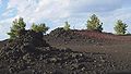
A typical eruption along the Great Rift and similar basaltic rift systems starts with a curtain of very fluid lava shooting up to 1000 feet (304.8 m) high along a segment of the rift up to 1 miles (1.6 km) long. As the eruption continues, pressure and heat decrease and the chemistry of the lava becomes slightly more silica rich. The curtain of lava responds by breaking apart into separate vents. Various types of volcanos may form at these vents: gas-rich pulverized lava creates cinder cone
s (such as Inferno Cone – stop 4), and pasty lava blobs form spatter cones (such as Spatter Cones – stop 5). Later stages of an eruption push lava streams out through the side or base of cinder cones, which usually ends the life of the cinder cone (North Crater, Watchmen, and Sheep Trail Butte are notable exceptions). This will sometimes breach part of the cone and carry it away as large and craggy blocks of cinder (as seen at North Crater Flow – stop 2 – and Devils Orchard – stop 3). Solid crust forms over lava streams and lava tubes (a type of cave), and are created when lava vacates its course (examples can be seen at the Cave Area – stop 7).
Geologists feared that a large earthquake
that shook Borah Peak
, Idaho's tallest mountain, in 1983 would restart volcanic activity at Craters of the Moon, though this proved not to be the case. Geologists predict that the area will experience its next eruption some time in the next 900 years with the most likely period in the next 100 years.Eruptions were dated using paleomagnetic
and radiocarbon
methods, which together give dates that are considered accurate to within 100 years . Both tests were conducted in 1980 by using charred vegetation directly below individual flows (for the radiocarbon test), and from rock core samples (for the paleomagnetic work).
 All plants and animals that live in and around Craters of the Moon are under great environmental stress due to constant dry wind
s and heat-absorbing black lavas that tend to quickly sap water from living things. Summer soil
temperatures often exceed 150 °F (65.6 °C) and plant cover is generally less than 5% on cinder cones and about 15% over the entire monument. Adaptation is therefore necessary for survival in this semi-arid
harsh climate
.
Water is usually only found deep inside holes at the bottom of blow-out craters. Animals therefore get the moisture they need directly from their food. The black soil on and around cinder cones does not hold moisture for long, making it difficult for plants to establish themselves. Soil particles first develop from direct rock decomposition by lichen
s and typically collect in crevices in lava flows. Successively more complex plants then colonize the microhabitat created by the increasingly productive soil.
The shaded north slopes of cinder cones provide more protection from direct sun
light and prevailing southwesterly winds and have a more persistent snow cover (an important water source in early spring). These parts of cinder cones are therefore colonized by plants first.
Gaps between lava flows were sometimes cut-off from surrounding vegetation. These literal islands of habitat are called kīpuka
s, a Hawaiian
name used for older land surrounded by younger lava. Carey Kīpuka is one such area in the southernmost part of the monument and is used as a benchmark to measure how plant cover has changed in less pristine parts of southern Idaho.
of plant known to grow in the monument. When wildflowers are not in bloom, most of the vegetation is found in semi-hidden pockets and consists of pine trees, cedars, juniper
s, and sagebrush
. Strategies used by plants to cope with the adverse conditions include:
A common plant seen on the lava field is the Dwarf Buckwheat
(photo), a flowering plant 4 inches (101.6 mm) tall with a root system 3 foot (0.9144 m) wide. The root system monopolizes soil moisture in its immediate area, resulting in individual plants that are evenly spaced. Consequently, many visitors have asked park rangers if the buckwheat were systematically planted.
Wildflower
s bloom from early May to late September but most are gone by late August. Moisture from snow-melt along with some rainfall in late spring kick-starts the germination
of annual plants, including wildflowers. Most of these plants complete their entire life cycle
in the few months each year that moisture levels are good. The onset of summer decreases the number of wildflowers and by autumn only the tiny yellow flowers of sagebrush and rabbitbrush remain. Some wildflowers that grow in the area are the Arrow-leaved
Balsamroot
, Bitterroot
, Blazing Star
, Desert Parsley
, Dwarf Monkeyflower, Paintbrush
, Scorpionweed
, Scabland Penstemon and the Wild Onion
.
). Birds and some rodent
s are seen most frequently in the Craters of the Moon area. Brown Bear
s once roamed this area but have long ago become locally extinct
. Traditional livestock
grazing continues within the grass/shrublands administered by the BLM.
Most desert animals are nocturnal, or mainly active at night. Nocturnal behavior is an adaptation to both predation and hot summer daytime temperatures. Nocturnal animals at Craters of the Moon include woodrats (also called packrats), skunk
s, fox
es, bobcat
s, mountain lions, bat
s, nighthawk
s, owl
s, and most other small desert rodents.
Animals that are most active at dawn and dusk, when temperatures are cooler than mid-day, are called crepuscular
. The subdued morning and evening light helps make them less visible to predators, but is bright enough to allow them to locate food. Some animals are crepuscular mainly because their prey is. Crepuscular animals in the area include mule deer
, coyote
s, porcupine
s, Mountain Cottontail
s, jackrabbits, and many songbird
s.
Some desert animals are diurnal, or primarily active during the day. These include ground squirrel
s, marmot
s, chipmunk
s, lizard
s, snake
s, hawk
s, and eagle
s.
Many animals have a specific temperature range where they are active, meaning the times they are active vary with the seasons. Snakes and lizards hibernate
during the winter months, are diurnal during the late spring and early fall, and become crepuscular during the heat of summer. Many insects and some birds also alter their times of activity. Some animals, like ground squirrels and marmots, have one or more periods of estivation
, a summer hibernation that allows them to avoid the hottest and driest periods.
Several animals are unique to Craters of the Moon and the surrounding area. Subspecies of Great Basin Pocket Mouse
, pika
, Yellow-pine Chipmunk
, and Yellow-bellied Marmot
are found nowhere else. Lava tube beetles and many other cave animals are found only in the lava tubes of eastern Idaho.
started a three year study to mark and count the Mule Deer
in the monument. The National Park Service
was concerned that the local herd might grow so large that it would damage its habitat. Griffith found that this group of Mule Deer has developed a totally unique drought
evasion strategy for its species.
The deer
arrive in the southern part of the pre-2000 extent of the monument mid-April each year once winter snows have melted away enough to allow for foraging. Griffith found that by late summer plants in the area have already matured and dried to the point that they can no longer provide enough moisture to sustain the deer. In late July after about 12 days above 80 °F (26.7 °C) and warm nights above 50 °F (10 °C) the herd migrates 5 to 10 mi (8 to 16.1 km) north to the Pioneer Mountains to obtain water from free-flowing streams and shade themselves in aspen
and Douglas-fir
groves. Rain in late September prompts the herd to return to the monument to feed on bitterbrush until snow in November triggers them to migrate back to their winter range. This herd, therefore, has a dual summer range. It is also very productive with one of the highest fawn survival rates of any herd in the species.
Afternoon winds usually die down in the evening, prompting behavioral modifications in the herd. The deer avoid the dry wind by being more active at night when the wind is not blowing. In 1991 there was a three-year average of 420 Mule Deer.
s, shrubs, trees, and wild animals can be seen by hiking on one of the many trails in the monument or by just pulling over into one of the turn-offs. More rugged hiking opportunities are available in the Craters of the Moon Wilderness Area and Backcountry Area, the roadless southern and major part of the monument.
Craters of the Moon Campground has 51 sites – none of which can be reserved in advance. Camping
facilities are basic but do include water, restrooms, charcoal grills, and trash containers. National Park Service
rangers present evening programs at the campground amphitheater in the summer. Camping enables visitors to enjoy the park during the evening and morning, when the heat, glare and wind are far less.
A Lunar Ranger program enables children to earn an embroidered patch in a few hours.
Backcountry hiking
is available in the Craters of the Moon Wilderness and the much larger Backcountry Area beyond (added in 2000). Only two trails enter the wilderness area and even those stop after a few miles or kilometers. From there most hikers follow the Great Rift and explore its series of seldom-visited volcanic features. All overnight backcountry hikes require registration with a ranger. No drinking water is available in the backcountry and the dry climate quickly dehydrates hikers. Avoiding summer heat and winter cold are therefore recommended by rangers. Pets, camp fires, and all mechanized vehicles, including bicycles, are not allowed in the wilderness area.
Skiing is allowed on the Loop Drive after it is closed to traffic in late November due to snow drifts. Typically there are 20 inches (50.8 cm) of snow by January and 25 in (63.5 cm) by February. Cross-country skiing
off of Loop Drive is allowed but may be dangerous due to sharp lava and hidden holes under the snow. Blizzard
s and other inclement weather may occur.
U.S. National Monument
A National Monument in the United States is a protected area that is similar to a National Park except that the President of the United States can quickly declare an area of the United States to be a National Monument without the approval of Congress. National monuments receive less funding and...
and national preserve
National preserve
National Preserve is a designation applied by the United States Congress to protected areas that have characteristics normally associated with U.S. National Parks but where certain activities not allowed in National Parks are permitted. These activities include public hunting, trapping, and oil...
located in the Snake River Plain
Snake River Plain
The Snake River Plain is a geologic feature located primarily within the state of Idaho in the United States of America. It stretches about westward from northwest of the state of Wyoming to the Idaho-Oregon border. The plain is a wide flat bow-shaped depression, and covers about a quarter of Idaho...
in central Idaho
Idaho
Idaho is a state in the Rocky Mountain area of the United States. The state's largest city and capital is Boise. Residents are called "Idahoans". Idaho was admitted to the Union on July 3, 1890, as the 43rd state....
, U.S.A. It is along US 20 (concurrent
Concurrency (road)
A concurrency, overlap, or coincidence in a road network is an instance of one physical road bearing two or more different highway, motorway, or other route numbers...
with US 93 & US 26), between the small cities of Arco
Arco, Idaho
Arco is a city in Butte County, Idaho, United States. The population was 995 at the 2010 census. The city is the county seat of Butte County.Craters of the Moon National Monument is located along U.S. Route 20, southwest of the city. The Idaho National Laboratory is located east of Arco...
and Carey
Carey, Idaho
Carey is a city in Blaine County, Idaho, United States. The population was 513 at the 2000 census. Carey is primarily an agricultural city and is the location of the Blaine County Fairgrounds. Nearby recreational destinations include the Craters of the Moon National Monument, Carey Lake, Silver...
, at an average elevation of 5900 feet (1,798.3 m) above sea level. The protected area
Protected area
Protected areas are locations which receive protection because of their recognised natural, ecological and/or cultural values. There are several kinds of protected areas, which vary by level of protection depending on the enabling laws of each country or the regulations of the international...
's features are volcanic
Volcano
2. Bedrock3. Conduit 4. Base5. Sill6. Dike7. Layers of ash emitted by the volcano8. Flank| 9. Layers of lava emitted by the volcano10. Throat11. Parasitic cone12. Lava flow13. Vent14. Crater15...
and represent one of the best preserved flood basalt
Flood basalt
A flood basalt or trap basalt is the result of a giant volcanic eruption or series of eruptions that coats large stretches of land or the ocean floor with basalt lava. Flood basalts have occurred on continental scales in prehistory, creating great plateaus and mountain ranges...
areas in the continental United States.
The Monument was established on May 2, 1924. In November 2000, a presidential proclamation by President Clinton
Bill Clinton
William Jefferson "Bill" Clinton is an American politician who served as the 42nd President of the United States from 1993 to 2001. Inaugurated at age 46, he was the third-youngest president. He took office at the end of the Cold War, and was the first president of the baby boomer generation...
greatly expanded the Monument area. The National Park Service
National Park Service
The National Park Service is the U.S. federal agency that manages all national parks, many national monuments, and other conservation and historical properties with various title designations...
portions of the expanded Monument were designated as Craters of the Moon National Preserve in August 2002. It lies in parts of Blaine
Blaine County, Idaho
Blaine County is a county located in the U.S. state of Idaho. As of the 2010 Census the county had a population of 21,376. The county seat and largest city is Hailey. The county is home to the Sun Valley ski resort....
, Butte
Butte County, Idaho
Butte County is a rural county located in the U.S. state of Idaho. It was established in 1917, and its county seat and largest city is Arco. As of the 2010 census, the county had a population of 2,891...
, Lincoln
Lincoln County, Idaho
Lincoln County is a county located in the U.S. state of Idaho. As of the 2000 census the county had a population of 4,044 The county seat and largest city is Shoshone....
, Minidoka
Minidoka County, Idaho
Minidoka County is a county located in the U.S. state of Idaho. The county seat and largest city is Rupert. As of the 2000 Census the county had a population of 20,174 ....
, and Power
Power County, Idaho
Power County is a county located in the U.S. state of Idaho. As of the 2000 Census the county had a population of 7,538 ....
counties. The area is managed cooperatively by the National Park Service and the Bureau of Land Management
Bureau of Land Management
The Bureau of Land Management is an agency within the United States Department of the Interior which administers America's public lands, totaling approximately , or one-eighth of the landmass of the country. The BLM also manages of subsurface mineral estate underlying federal, state and private...
(BLM).
The Monument and Preserve encompass three major lava fields and about 400 square miles (1,036 km²) of sagebrush
Sagebrush
Sagebrush is a common name of a number of shrubby plant species in the genus Artemisia native to western North America;Or, the sagebrush steppe ecoregion, having one or more kinds of sagebrush, bunchgrasses and others;...
steppe grassland
Grassland
Grasslands are areas where the vegetation is dominated by grasses and other herbaceous plants . However, sedge and rush families can also be found. Grasslands occur naturally on all continents except Antarctica...
s to cover a total area of 1117 square miles (2,893 km²). All three lava fields lie along the Great Rift of Idaho, with some of the best examples of open rift cracks in the world, including the deepest known on Earth at 800 feet (243.8 m). There are excellent examples of almost every variety of basalt
Basalt
Basalt is a common extrusive volcanic rock. It is usually grey to black and fine-grained due to rapid cooling of lava at the surface of a planet. It may be porphyritic containing larger crystals in a fine matrix, or vesicular, or frothy scoria. Unweathered basalt is black or grey...
ic lava as well as tree molds (cavities left by lava-incinerated trees), lava tube
Lava tube
Lava tubes are natural conduits through which lava travels beneath the surface of a lava flow, expelled by a volcano during an eruption. They can be actively draining lava from a source, or can be extinct, meaning the lava flow has ceased and the rock has cooled and left a long, cave-like...
s (a type of cave
Cave
A cave or cavern is a natural underground space large enough for a human to enter. The term applies to natural cavities some part of which is in total darkness. The word cave also includes smaller spaces like rock shelters, sea caves, and grottos.Speleology is the science of exploration and study...
), and many other volcanic features.
Geography and geologic setting
The Craters of the Moon Lava Field spreads across 618 square miles (1,601 km²) and is the largest mostly HoloceneHolocene
The Holocene is a geological epoch which began at the end of the Pleistocene and continues to the present. The Holocene is part of the Quaternary period. Its name comes from the Greek words and , meaning "entirely recent"...
-aged basaltic lava field in the lower 48 U.S. state
U.S. state
A U.S. state is any one of the 50 federated states of the United States of America that share sovereignty with the federal government. Because of this shared sovereignty, an American is a citizen both of the federal entity and of his or her state of domicile. Four states use the official title of...
s. The Monument and Preserve contain more than 25 volcanic cones including outstanding examples of spatter cones
Volcanic cone
Volcanic cones are among the simplest volcanic formations. They are built by ejecta from a volcanic vent, piling up around the vent in the shape of a cone with a central crater. Volcanic cones are of different types, depending upon the nature and size of the fragments ejected during the eruption...
. The 60 distinct lava flows that form the Craters of the Moon Lava Field range in age from 15,000 to just 2,000 years. The Kings Bowl and Wapi lava fields, both about 2,200 years old, are part of the National Preserve.
Craters of the Moon Lava Field reaches southeastward from the Pioneer Mountains
Pioneer Mountains (Idaho)
The Pioneer Mountains is a mountain range in the U.S. state of Idaho, spanning Blaine, Butte and Custer counties. The range is bounded on the west by the Big Wood River, Trail Creek and Summit Creek, and the North Fork Big Lost River, on the north and east by the East Fork Big Lost River, Left Fork...
. This lava field is the largest of several large beds of lava that erupted from the 53 miles (85.3 km) south-east to north-west trending Great Rift volcanic zone—a line of weakness in the Earth's crust created by Basin and Range
Basin and Range
The Basin and Range Province is a vast physiographic region defined by a unique topographic expression. Basin and Range topography is characterized by abrupt changes in elevation, alternating between narrow faulted mountain chains and flat arid valleys or basins...
rifting. Together with fields from other fissures they make up the Lava Beds of Idaho, which in turn are located within the much larger Snake River Plain
Snake River Plain
The Snake River Plain is a geologic feature located primarily within the state of Idaho in the United States of America. It stretches about westward from northwest of the state of Wyoming to the Idaho-Oregon border. The plain is a wide flat bow-shaped depression, and covers about a quarter of Idaho...
volcanic province. The Great Rift almost extends across the entire Snake River Plain.
The rugged landscape remains remote and undeveloped with only one paved road across the northern end. Craters of the Moon is located in south-central Idaho midway between Boise
Boise, Idaho
Boise is the capital and most populous city of the U.S. state of Idaho, as well as the county seat of Ada County. Located on the Boise River, it anchors the Boise City-Nampa metropolitan area and is the largest city between Salt Lake City, Utah and Portland, Oregon.As of the 2010 Census Bureau,...
and Yellowstone National Park
Yellowstone National Park
Yellowstone National Park, established by the U.S. Congress and signed into law by President Ulysses S. Grant on March 1, 1872, is a national park located primarily in the U.S. state of Wyoming, although it also extends into Montana and Idaho...
, and its elevation at the visitor center is 5900 feet (1,798.3 m) above sea level. Combined U.S. Highway 20-26-93 cuts through the northwestern part of the monument and provides access to it.
Total average precipitation
Precipitation (meteorology)
In meteorology, precipitation In meteorology, precipitation In meteorology, precipitation (also known as one of the classes of hydrometeors, which are atmospheric water phenomena is any product of the condensation of atmospheric water vapor that falls under gravity. The main forms of precipitation...
in the Craters of the Moon area is between 15–20 in (381–508 mm) per year.Lower elevation areas near the Snake River
Snake River
The Snake is a major river of the greater Pacific Northwest in the United States. At long, it is the largest tributary of the Columbia River, the largest North American river that empties into the Pacific Ocean...
average only 10–11 inches of precipitation annually. Most of this is lost in cracks in the basalt
Basalt
Basalt is a common extrusive volcanic rock. It is usually grey to black and fine-grained due to rapid cooling of lava at the surface of a planet. It may be porphyritic containing larger crystals in a fine matrix, or vesicular, or frothy scoria. Unweathered basalt is black or grey...
, only to emerge later in springs and seeps in the walls of the Snake River Canyon
Snake River Canyon (Idaho)
Snake River Canyon is a large canyon formed by the Snake River in the Magic Valley region of southern Idaho. It is well known as the site of an unsuccessful 1974 attempt by Evel Knievel to jump it in the Skycycle X-2....
. Older lava fields on the plain have been invaded by drought
Drought
A drought is an extended period of months or years when a region notes a deficiency in its water supply. Generally, this occurs when a region receives consistently below average precipitation. It can have a substantial impact on the ecosystem and agriculture of the affected region...
-resistant plants such as sagebrush
Sagebrush
Sagebrush is a common name of a number of shrubby plant species in the genus Artemisia native to western North America;Or, the sagebrush steppe ecoregion, having one or more kinds of sagebrush, bunchgrasses and others;...
, while younger fields, such as Craters of the Moon, only have a seasonal and very sparse cover of vegetation. From a distance this cover disappears almost entirely, giving an impression of utter black desolation. Repeated lava flows over the last 15,000 years have raised the land surface enough to expose it to the prevailing southwesterly winds, which help to keep the area dry. Together these conditions make life on the lava field difficult.
Native American history
Paleo-Indians visited the area about 12,000 years ago but did not leave much archaeological evidence. Northern ShoshoneShoshone
The Shoshone or Shoshoni are a Native American tribe in the United States with three large divisions: the Northern, the Western and the Eastern....
created trails through the Craters of the Moon Lava Field during their summer migrations from the Snake River
Snake River
The Snake is a major river of the greater Pacific Northwest in the United States. At long, it is the largest tributary of the Columbia River, the largest North American river that empties into the Pacific Ocean...
to the Camas Prairie
Camas prairie
The name camas prairie refers to several distinct geographical areas in the western United States which were named for the native perennial camassia or camas, including regions in the states of Idaho, Montana, Oregon and Washington...
, west of the lava field. Stone windbreaks at Indian Tunnel were used to protect campsites from the dry summer wind. No evidence exists for permanent habitation by any Native American group. A hunting and gathering
Hunting and gathering
Hunting and gathering may refer to:*Hunting and gathering, the subsistence method based on edible plants and animals from the wild*Hunting and Gathering...
culture, the Northern Shoshone pursued Elk
Elk
The Elk is the large deer, also called Cervus canadensis or wapiti, of North America and eastern Asia.Elk may also refer to:Other antlered mammals:...
, bear
Bear
Bears are mammals of the family Ursidae. Bears are classified as caniforms, or doglike carnivorans, with the pinnipeds being their closest living relatives. Although there are only eight living species of bear, they are widespread, appearing in a wide variety of habitats throughout the Northern...
s, American Bison
American Bison
The American bison , also commonly known as the American buffalo, is a North American species of bison that once roamed the grasslands of North America in massive herds...
, Cougars, and Bighorn Sheep
Bighorn Sheep
The bighorn sheep is a species of sheep in North America named for its large horns. These horns can weigh up to , while the sheep themselves weigh up to . Recent genetic testing indicates that there are three distinct subspecies of Ovis canadensis, one of which is endangered: Ovis canadensis sierrae...
—all large game who no longer range the area. The most recent volcanic eruptions ended about 2,100 years ago and were likely witnessed by the Shoshone people. Shoshone legend speaks of a serpent on a mountain who, angered by lightning, coiled around and squeezed the mountain until liquid rock flowed, fire shot from cracks, and the mountain exploded.
Goodale's Cutoff
European fur trappersTrapping (Animal)
Animal trapping, or simply trapping, is the use of a device to remotely catch an animal. Animals may be trapped for a variety of purposes, including food, wildlife management, hunting, and pest control...
avoided the lava field area below the Pioneer Mountains by following Indian trails. Early white pioneers who sought gold
Gold
Gold is a chemical element with the symbol Au and an atomic number of 79. Gold is a dense, soft, shiny, malleable and ductile metal. Pure gold has a bright yellow color and luster traditionally considered attractive, which it maintains without oxidizing in air or water. Chemically, gold is a...
, affordable farm land to raise crops, or cheap ranch land to range cattle also avoided the lava fields and considered them useless.
Wagon train
A wagon train is a group of wagons traveling together. In the American West, individuals traveling across the plains in covered wagons banded together for mutual assistance, as is reflected in numerous films and television programs about the region, such as Audie Murphy's Tumbleweed and Ward Bond...
s on the Oregon Trail
Oregon Trail
The Oregon Trail is a historic east-west wagon route that connected the Missouri River to valleys in Oregon and locations in between.After 1840 steam-powered riverboats and steamboats traversing up and down the Ohio, Mississippi and Missouri rivers sped settlement and development in the flat...
in the 1850s and 1860s followed an alternate route in the area that used old Indian trails that skirted the lava flows. This alternate route was later named Goodale's Cutoff
Goodale's Cutoff
Goodale's Cutoff formed a spur of the Oregon Trail in Idaho, United States. The cutoff left the trail near Fort Hall, crossed the Snake River Plain to the Lost River, and then turned west to the area of Boise, crossing Camas Prairie...
and part of it is located in the northern part of the monument. The cutoff was created to reduce the possibility of ambush by Shoshone warriors along the Snake River
Snake River
The Snake is a major river of the greater Pacific Northwest in the United States. At long, it is the largest tributary of the Columbia River, the largest North American river that empties into the Pacific Ocean...
such as the one that occurred at Massacre Rocks, which today is memorialized in Idaho's Massacre Rocks State Park
Massacre Rocks State Park
Massacre Rocks State Park is a state park of Idaho, USA, featuring the Massacre Rocks, a famous spot along the Oregon Trail and California Trail during the middle 19th century...
.
After gold
Gold
Gold is a chemical element with the symbol Au and an atomic number of 79. Gold is a dense, soft, shiny, malleable and ductile metal. Pure gold has a bright yellow color and luster traditionally considered attractive, which it maintains without oxidizing in air or water. Chemically, gold is a...
was discovered in the Salmon River
Salmon River (Idaho)
The Salmon River is located in Idaho in the northwestern United States. The Salmon is also known as The River of No Return. It flows for through central Idaho, draining and dropping more than between its headwaters, near Galena Summit above the Sawtooth Valley in the Sawtooth National...
area of Idaho, a group of emigrants persuaded an Illinois
Illinois
Illinois is the fifth-most populous state of the United States of America, and is often noted for being a microcosm of the entire country. With Chicago in the northeast, small industrial cities and great agricultural productivity in central and northern Illinois, and natural resources like coal,...
-born trapper and trader named Tim Goodale to lead them through the cutoff. A large wagon train
Wagon train
A wagon train is a group of wagons traveling together. In the American West, individuals traveling across the plains in covered wagons banded together for mutual assistance, as is reflected in numerous films and television programs about the region, such as Audie Murphy's Tumbleweed and Ward Bond...
left in July 1862 and met up with more wagon
Wagon
A wagon is a heavy four-wheeled vehicle pulled by draught animals; it was formerly often called a wain, and if low and sideless may be called a dray, trolley or float....
s at Craters of the Moon Lava Field. Numbering 795 men and 300 women and children, the unusually large group was relatively unmolested during its journey and named the cutoff for their guide. Improvements to the cutoff such as adding a ferry to cross the Snake River made it into a popular alternate route of the Oregon Trail.
Exploration and early study
In 1879, two Arco cattlemen named Arthur Ferris and J.W. Powell became the first known people to explore the lava fields. They were investigating its possible use for grazingGrazing
Grazing generally describes a type of feeding, in which a herbivore feeds on plants , and also on other multicellular autotrophs...
and watering cattle but found the area to be unsuitable and left.
U.S. Army
United States Army
The United States Army is the main branch of the United States Armed Forces responsible for land-based military operations. It is the largest and oldest established branch of the U.S. military, and is one of seven U.S. uniformed services...
Captain and western explorer B.L.E. Bonneville visited the lava fields and other places in the West in the 19th century and wrote about his experiences in his diaries. Washington Irving
Washington Irving
Washington Irving was an American author, essayist, biographer and historian of the early 19th century. He was best known for his short stories "The Legend of Sleepy Hollow" and "Rip Van Winkle", both of which appear in his book The Sketch Book of Geoffrey Crayon, Gent. His historical works...
later used Bonneville's diaries to write the Adventures of Captain Bonneville, saying this unnamed lava field is a place "where nothing meets the eye but a desolate and awful waste, where no grass grows nor water runs, and where nothing is to be seen but lava."
In 1901 and 1903, Israel Russell
Israel Russell
Israel Cook Russell, LL.D. was an American geologist and geographer who explored Alaska in the late 19th century. He was born at Garrattsville, New York, on the 10th of December 1852. He received B.S. and C.E...
became the first geologist
Geologist
A geologist is a scientist who studies the solid and liquid matter that constitutes the Earth as well as the processes and history that has shaped it. Geologists usually engage in studying geology. Geologists, studying more of an applied science than a theoretical one, must approach Geology using...
to study this area while surveying it for the United States Geological Survey
United States Geological Survey
The United States Geological Survey is a scientific agency of the United States government. The scientists of the USGS study the landscape of the United States, its natural resources, and the natural hazards that threaten it. The organization has four major science disciplines, concerning biology,...
(USGS). In 1910, Samuel Paisley continued Russell's work and later became the monument's first custodian. Others followed and in time much of the mystery surrounding this and the other Lava Beds of Idaho was lifted.
The few whites who visited the area in the 19th century created local legends that it looked like the surface of the Moon
Moon
The Moon is Earth's only known natural satellite,There are a number of near-Earth asteroids including 3753 Cruithne that are co-orbital with Earth: their orbits bring them close to Earth for periods of time but then alter in the long term . These are quasi-satellites and not true moons. For more...
. Geologists Harold T. Stearns coined the name "Craters of the Moon" in 1923 while trying to convince the National Park Service to recommend protection of the area in a national monument.
Limbert's expedition
Robert Limbert, a sometime taxidermist, tanner, and furrier from BoiseBoise, Idaho
Boise is the capital and most populous city of the U.S. state of Idaho, as well as the county seat of Ada County. Located on the Boise River, it anchors the Boise City-Nampa metropolitan area and is the largest city between Salt Lake City, Utah and Portland, Oregon.As of the 2010 Census Bureau,...
, explored the area, which he described as "practically unknown and unexplored ..." in the 1920s after hearing stories from fur trappers about "strange things they had seen while ranging the region".
Limbert wrote: "I had made two trips into the northern end, covering practically the same region as that traversed by a Geological Survey party in 1901. My first was a hiking and camping trip with Ad Santel (the wrestler), Dr. Dresser, and Albert Jones; the second was with Wes Watson and Era Martin (ranchers living about four miles [6 km] from the northern edge). The peculiar features seen on those trips led me to take a third across the region in the hope that even more interesting phenomena might be encountered."
Limbert set out on his third and most ambitious foray to the area in May 1920, this time with Walter L. Cole and an Airedale Terrier
Airedale Terrier
The Airedale Terrier is a breed of the terrier type that originated in Airedale, a geographic area in Yorkshire, England. It is traditionally called the "King of Terriers" because it is the largest of the terrier breeds...
to accompany him. Starting from Minidoka
Minidoka, Idaho
Minidoka is a city in Minidoka County, Idaho, United States. The population was 129 at the 2000 census. It is part of the Burley, Idaho Micropolitan Statistical Area....
, Idaho
Idaho
Idaho is a state in the Rocky Mountain area of the United States. The state's largest city and capital is Boise. Residents are called "Idahoans". Idaho was admitted to the Union on July 3, 1890, as the 43rd state....
, they explored what is now the monument area from south to north passing Two Point Butte, Echo Crater, Big Craters, North Crater Flow, and out of the lava field through the Yellowstone Park and Lincoln Highway (now known as the Old Arco-Carey Road). Taking the dog along was a mistake, Limbert wrote, "for after three days' travel his feet were worn and bleeding".
A series of newspaper and magazine articles written by Limbert were later published about this and previous treks, which increased public awareness of the area. The most famous of these was an article that appeared in a 1924 issue of National Geographic where he called the area "Craters of the Moon," helping to solidify the use of that name. In the article he had this to say about the cobalt
Cobalt
Cobalt is a chemical element with symbol Co and atomic number 27. It is found naturally only in chemically combined form. The free element, produced by reductive smelting, is a hard, lustrous, silver-gray metal....
blue of the Blue Dragon Flows:
- "It is the play of light at sunset across this lava that charms the spectator. It becomes a twisted, wavy sea. In the moonlight its glazed surface has a silvery sheen. With changing conditions of light and air, it varies also, even while one stands and watches. It is a place of color and silence ..."
Protection and later history
In large part due to Limbert's work, Craters of the Moon National Monument was proclaimed on May 2, 1924 by U.S. President Calvin CoolidgeCalvin Coolidge
John Calvin Coolidge, Jr. was the 30th President of the United States . A Republican lawyer from Vermont, Coolidge worked his way up the ladder of Massachusetts state politics, eventually becoming governor of that state...
to "preserve the unusual and weird volcanic formations". The Craters Inn and several cabins were built in 1927 for the convenience of visitors. The Mission 66 Program initiated construction of today's road system, visitor center, shop, campground and comfort station in 1956 and in 1959 the Craters of the Moon Natural History Association was formed to assist the monument in educational activities. The addition of an island of vegetation completely surrounded by lava known as Carey Kipuka (air photo) increased the size of the monument by 5360 acres (22 km²) in 1962.
Since then the monument has been enlarged. On October 23, 1970, Congress
United States Congress
The United States Congress is the bicameral legislature of the federal government of the United States, consisting of the Senate and the House of Representatives. The Congress meets in the United States Capitol in Washington, D.C....
set aside a large part of it—43243 acres (175 km²)—as Craters of the Moon National Wilderness
Craters of the Moon National Wilderness
The Craters of the Moon National Wilderness is located in the U.S. state of Idaho. The wilderness is managed by the National Park Service and is integral with Craters of the Moon National Monument. Set aside to protect volcanic features which ended 2,100 years ago, the wilderness has numerous lava...
, protecting that part under the National Wilderness Preservation System
National Wilderness Preservation System
The National Wilderness Preservation System of the United States protects federally managed land areas designated for preservation in their natural condition. It was established by the Wilderness Act upon the signature of President Lyndon B. Johnson on September 3, 1964...
.
From 1969 to 1972, NASA
NASA
The National Aeronautics and Space Administration is the agency of the United States government that is responsible for the nation's civilian space program and for aeronautics and aerospace research...
visited the real Moon through the Apollo program and found that its surface does not closely resemble this part of Idaho. NASA astronauts discovered that real Moon craters were almost all created by meteorite
Meteorite
A meteorite is a natural object originating in outer space that survives impact with the Earth's surface. Meteorites can be big or small. Most meteorites derive from small astronomical objects called meteoroids, but they are also sometimes produced by impacts of asteroids...
s while their namesakes on Earth were created by volcanic eruptions; both are desolate. Apollo astronauts performed part of their training at Craters of the Moon Lava Field by learning to look for and collect good rock
Rock (geology)
In geology, rock or stone is a naturally occurring solid aggregate of minerals and/or mineraloids.The Earth's outer solid layer, the lithosphere, is made of rock. In general rocks are of three types, namely, igneous, sedimentary, and metamorphic...
specimens in an unfamiliar and harsh environment.
For many years, geologists, biologists and environmentalists have advocated for expansion of the monument and its transformation into a national park. Part of that goal was reached in 2000 when the monument was expanded 13-fold from 53545 acres (217 km²) to its current size to encompass the entire Great Rift zone and its three lava fields. The entire addition is called the Backcountry Area while the two older parts are called the Developed Area and Wilderness Area. Opposition by cattle interests and hunters to a simple expansion plan led to a compromise of having the addition become a national preserve
National preserve
National Preserve is a designation applied by the United States Congress to protected areas that have characteristics normally associated with U.S. National Parks but where certain activities not allowed in National Parks are permitted. These activities include public hunting, trapping, and oil...
in 2002 (which allows hunting, not ordinarily permitted in national parks and monuments in the U.S.). Craters of the Moon National Monument and Preserve is co-managed by the National Park Service
National Park Service
The National Park Service is the U.S. federal agency that manages all national parks, many national monuments, and other conservation and historical properties with various title designations...
and the Bureau of Land Management
Bureau of Land Management
The Bureau of Land Management is an agency within the United States Department of the Interior which administers America's public lands, totaling approximately , or one-eighth of the landmass of the country. The BLM also manages of subsurface mineral estate underlying federal, state and private...
, both under the Department of the Interior
United States Department of the Interior
The United States Department of the Interior is the United States federal executive department of the U.S. government responsible for the management and conservation of most federal land and natural resources, and the administration of programs relating to Native Americans, Alaska Natives, Native...
.
Geology
The Snake River PlainSnake River Plain
The Snake River Plain is a geologic feature located primarily within the state of Idaho in the United States of America. It stretches about westward from northwest of the state of Wyoming to the Idaho-Oregon border. The plain is a wide flat bow-shaped depression, and covers about a quarter of Idaho...
is a volcanic province that was created by a series of cataclysmic caldera
Caldera
A caldera is a cauldron-like volcanic feature usually formed by the collapse of land following a volcanic eruption, such as the one at Yellowstone National Park in the US. They are sometimes confused with volcanic craters...
-forming super-eruptions
Supervolcano
A supervolcano is a volcano capable of producing a volcanic eruption with an ejecta volume greater than 1,000 cubic kilometers . This is thousands of times larger than most historic volcanic eruptions. Supervolcanoes can occur when magma in the Earth rises into the crust from a hotspot but is...
which started about 15 million years ago. A migrating hotspot
Hotspot (geology)
The places known as hotspots or hot spots in geology are volcanic regions thought to be fed by underlying mantle that is anomalously hot compared with the mantle elsewhere. They may be on, near to, or far from tectonic plate boundaries. There are two hypotheses to explain them...
thought to now exist under Yellowstone Caldera
Yellowstone Caldera
The Yellowstone Caldera is the volcanic caldera located in Yellowstone National Park in the United States, sometimes referred to as the Yellowstone Supervolcano. The caldera is located in the northwest corner of Wyoming, in which the vast majority of the park is contained. The major features of...
in Yellowstone National Park has been implicated. This hot spot was under the Craters of the Moon area some 10 to 11 million years ago but 'moved' as the North American Plate
North American Plate
The North American Plate is a tectonic plate covering most of North America, Greenland, Cuba, Bahamas, and parts of Siberia, Japan and Iceland. It extends eastward to the Mid-Atlantic Ridge and westward to the Chersky Range in eastern Siberia. The plate includes both continental and oceanic crust...
migrated southwestward.Meaning Craters of the Moon once looked like Yellowstone does today and Yellowstone will one day look much like Craters of the Moon does now. Actually the hot spot stays in the same place while the overlying continent of North America moves. Pressure from the hot spot heaves the land surface up, creating fault-block mountain
Fault-block mountain
Fault-block landforms are formed when large areas of bedrock are widely broken up by faults creating large vertical displacements of continental crust....
s. After the hot spot passes the pressure is released and the land subsides.
Leftover heat from this hot spot was later liberated by Basin and Range
Basin and Range
The Basin and Range Province is a vast physiographic region defined by a unique topographic expression. Basin and Range topography is characterized by abrupt changes in elevation, alternating between narrow faulted mountain chains and flat arid valleys or basins...
-associated rifting and created the many overlapping lava flows that make up the Lava Beds of Idaho. The largest rift zone is the Great Rift; it is from this 'Great Rift fissure system' that Craters of the Moon, Kings Bowl, and Wapi lava fields were created.
In spite of their fresh appearance, the oldest flows in the Craters of the Moon Lava Field are 15,000 years old and the youngest erupted about 2000 years ago, according to Mel Kuntz and other USGS geologists. Nevertheless the volcanic fissures at Craters of the Moon are considered to be dormant, not extinct, and are expected to erupt in less than a thousand years. There are eight major eruptive periods recognized in the Craters of the Moon Lava Field. Each period lasted about 1000 years or less and were separated by relatively quiet periods that lasted between 500 to as long as 3000 years. Individual lava flows were up to 30 miles (48.3 km) long with the Blue Dragon Flow being the longest.
Kings Bowl Lava Field erupted during a single fissure eruption on the southern part of the Great Rift about 2,250 years ago. This eruption probably lasted only a few hours to a few days. The field preserves explosion pits, lava lakes, squeeze-ups, basalt mounds, and an ash blanket. The Wapi Lava Field probably formed from a fissure eruption at the same time as the Kings Bowl eruption. More prolonged activity over a period of months to a few years led to the formation of low shield volcano
Shield volcano
A shield volcano is a type of volcano usually built almost entirely of fluid lava flows. They are named for their large size and low profile, resembling a warrior's shield. This is caused by the highly fluid lava they erupt, which travels farther than lava erupted from more explosive volcanoes...
s-(?) in the Wapi field. The Bear Trap lava tube, located between the Craters of the Moon and the Wapi lava fields, is a cave
Cave
A cave or cavern is a natural underground space large enough for a human to enter. The term applies to natural cavities some part of which is in total darkness. The word cave also includes smaller spaces like rock shelters, sea caves, and grottos.Speleology is the science of exploration and study...
system more than 15 miles (24 km) long. The lava tube is remarkable for its length and for the number of well-preserved lava cave features, such as lava stalactites and curbs, the latter marking high stands of the flowing lava forever frozen on the lava tube walls. The lava tubes and pit crater
Pit crater
A pit crater is a depression formed by a sinking of the ground surface lying above a void or empty chamber, rather than by the eruption of a volcano or lava vent. It is often found in chains or troughs. Several craters may merge into a linear alignment...
s of the monument are known for their unusual preservation of winter ice and snow into the hot summer months, due to shielding from the sun and the insulating properties of basalt.
A typical eruption along the Great Rift and similar basaltic rift systems starts with a curtain of very fluid lava shooting up to 1000 feet (304.8 m) high along a segment of the rift up to 1 miles (1.6 km) long. As the eruption continues, pressure and heat decrease and the chemistry of the lava becomes slightly more silica rich. The curtain of lava responds by breaking apart into separate vents. Various types of volcanos may form at these vents: gas-rich pulverized lava creates cinder cone
Cinder cone
According to the , Cinder Cone is the proper name of 1 cinder cone in Canada and 7 cinder cones in the United States:In Canada: Cinder Cone In the United States:...
s (such as Inferno Cone – stop 4), and pasty lava blobs form spatter cones (such as Spatter Cones – stop 5). Later stages of an eruption push lava streams out through the side or base of cinder cones, which usually ends the life of the cinder cone (North Crater, Watchmen, and Sheep Trail Butte are notable exceptions). This will sometimes breach part of the cone and carry it away as large and craggy blocks of cinder (as seen at North Crater Flow – stop 2 – and Devils Orchard – stop 3). Solid crust forms over lava streams and lava tubes (a type of cave), and are created when lava vacates its course (examples can be seen at the Cave Area – stop 7).
Geologists feared that a large earthquake
1983 Borah Peak earthquake
The 1983 Borah Peak earthquake occurred on October 28, 1983, in the Lost River Range at Borah Peak in central Idaho, United States. The most significant earthquake recorded in the state, it occurred on a Friday morning at 8:06 am MDT. The earthquake was a magnitude 7.3, and 6.9 on the Richter scale...
that shook Borah Peak
Borah Peak
Borah Peak is the highest mountain in the U.S. state of Idaho. It is located in the central section of the Lost River Range, within the Challis National Forest in eastern Custer County. The peak is named for William Borah , a prominent U.S...
, Idaho's tallest mountain, in 1983 would restart volcanic activity at Craters of the Moon, though this proved not to be the case. Geologists predict that the area will experience its next eruption some time in the next 900 years with the most likely period in the next 100 years.Eruptions were dated using paleomagnetic
Paleomagnetism
Paleomagnetism is the study of the record of the Earth's magnetic field in rocks. Certain minerals in rocks lock-in a record of the direction and intensity of the magnetic field when they form. This record provides information on the past behavior of Earth's magnetic field and the past location of...
and radiocarbon
Radiocarbon dating
Radiocarbon dating is a radiometric dating method that uses the naturally occurring radioisotope carbon-14 to estimate the age of carbon-bearing materials up to about 58,000 to 62,000 years. Raw, i.e. uncalibrated, radiocarbon ages are usually reported in radiocarbon years "Before Present" ,...
methods, which together give dates that are considered accurate to within 100 years . Both tests were conducted in 1980 by using charred vegetation directly below individual flows (for the radiocarbon test), and from rock core samples (for the paleomagnetic work).
Conditions
Wind
Wind is the flow of gases on a large scale. On Earth, wind consists of the bulk movement of air. In outer space, solar wind is the movement of gases or charged particles from the sun through space, while planetary wind is the outgassing of light chemical elements from a planet's atmosphere into space...
s and heat-absorbing black lavas that tend to quickly sap water from living things. Summer soil
Soil
Soil is a natural body consisting of layers of mineral constituents of variable thicknesses, which differ from the parent materials in their morphological, physical, chemical, and mineralogical characteristics...
temperatures often exceed 150 °F (65.6 °C) and plant cover is generally less than 5% on cinder cones and about 15% over the entire monument. Adaptation is therefore necessary for survival in this semi-arid
Semi-arid
A semi-arid climate or steppe climate describes climatic regions that receive precipitation below potential evapotranspiration, but not extremely...
harsh climate
Climate
Climate encompasses the statistics of temperature, humidity, atmospheric pressure, wind, rainfall, atmospheric particle count and other meteorological elemental measurements in a given region over long periods...
.
Water is usually only found deep inside holes at the bottom of blow-out craters. Animals therefore get the moisture they need directly from their food. The black soil on and around cinder cones does not hold moisture for long, making it difficult for plants to establish themselves. Soil particles first develop from direct rock decomposition by lichen
Lichen
Lichens are composite organisms consisting of a symbiotic organism composed of a fungus with a photosynthetic partner , usually either a green alga or cyanobacterium...
s and typically collect in crevices in lava flows. Successively more complex plants then colonize the microhabitat created by the increasingly productive soil.
The shaded north slopes of cinder cones provide more protection from direct sun
Sun
The Sun is the star at the center of the Solar System. It is almost perfectly spherical and consists of hot plasma interwoven with magnetic fields...
light and prevailing southwesterly winds and have a more persistent snow cover (an important water source in early spring). These parts of cinder cones are therefore colonized by plants first.
Gaps between lava flows were sometimes cut-off from surrounding vegetation. These literal islands of habitat are called kīpuka
Kipuka
A kīpuka is an area of land completely surrounded by one or more younger lava flows. A kīpuka forms when lava flows on either side of a hill, ridge, or older lava dome as it moves downslope or spreads from its source. Older and more weathered than their surroundings, kīpukas often appear to be like...
s, a Hawaiian
Hawaiian language
The Hawaiian language is a Polynesian language that takes its name from Hawaii, the largest island in the tropical North Pacific archipelago where it developed. Hawaiian, along with English, is an official language of the state of Hawaii...
name used for older land surrounded by younger lava. Carey Kīpuka is one such area in the southernmost part of the monument and is used as a benchmark to measure how plant cover has changed in less pristine parts of southern Idaho.
Plants
There are 375 speciesSpecies
In biology, a species is one of the basic units of biological classification and a taxonomic rank. A species is often defined as a group of organisms capable of interbreeding and producing fertile offspring. While in many cases this definition is adequate, more precise or differing measures are...
of plant known to grow in the monument. When wildflowers are not in bloom, most of the vegetation is found in semi-hidden pockets and consists of pine trees, cedars, juniper
Juniper
Junipers are coniferous plants in the genus Juniperus of the cypress family Cupressaceae. Depending on taxonomic viewpoint, there are between 50-67 species of juniper, widely distributed throughout the northern hemisphere, from the Arctic, south to tropical Africa in the Old World, and to the...
s, and sagebrush
Sagebrush
Sagebrush is a common name of a number of shrubby plant species in the genus Artemisia native to western North America;Or, the sagebrush steppe ecoregion, having one or more kinds of sagebrush, bunchgrasses and others;...
. Strategies used by plants to cope with the adverse conditions include:
- Drought tolerance by physiological adaptations such as the ability to survive extreme dehydrationDehydrationIn physiology and medicine, dehydration is defined as the excessive loss of body fluid. It is literally the removal of water from an object; however, in physiological terms, it entails a deficiency of fluid within an organism...
or the ability to extract water from very dry soil. Sagebrush and Antelope BitterbrushPurshia tridentataPurshia tridentata is a nitrogen fixing shrub in the genus Purshia, native to mountainous areas of western North America ranging from southeastern British Columbia in the north, east to Montana and south to California and New Mexico...
are examples. - Drought avoidance by having small, hairy, or succulent leaves to minimize moisture loss or otherwise conserve water. Hairs on scorpionweed, the succulent parts of the Pricklypear CactusOpuntiaOpuntia, also known as nopales or paddle cactus , is a genus in the cactus family, Cactaceae.Currently, only prickly pears are included in this genus of about 200 species distributed throughout most of the Americas. Chollas are now separated into the genus Cylindropuntia, which some still consider...
, and the small leaves of the WirelettuceStephanomeriaStephanomeria is a genus of plants also known as wirelettuce, belonging to the family Asteraceae. The ten perennial and six annual species are restricted to western North America....
are all local examples.
- Drought escape by growing in small crevices or near persistent water supplies, or by staying dormant for about 95% of the year. MossMossMosses are small, soft plants that are typically 1–10 cm tall, though some species are much larger. They commonly grow close together in clumps or mats in damp or shady locations. They do not have flowers or seeds, and their simple leaves cover the thin wiry stems...
es and fernFernA fern is any one of a group of about 12,000 species of plants belonging to the botanical group known as Pteridophyta. Unlike mosses, they have xylem and phloem . They have stems, leaves, and roots like other vascular plants...
s in the area grow near constant water sources such as natural potholes and seeps from ice caveIce caveThe term ice cave refers to any type of natural cave that contains significant amounts of perennial ice...
s. ScablandPenstemon deustusPenstemon deustus is a species of penstemon known by the common names hotrock penstemon and scabland beardtongue. It is native to much of the northwestern United States from the Pacific Northwest to Wyoming, where it grows in many types of forest and open plateau habitat, often on soils heavy in...
PenstemonPenstemonPenstemon , Beard-tongue, is a large genus of North American and East Asian plants traditionally placed in the Scrophulariaceae family. Due to new genetic research, it has now been placed in the vastly expanded family Plantaginaceae...
, Fernleaf FleabaneFleabaneFleabane is a common name for some flowering plants in the family Asteraceae.Most are in the subfamily Asteroideae:* Conyza * Erigeron * Inula...
, and Gland CinquefoilPotentillaPotentilla is the genus of typical cinquefoils, containing about 500 species of annual, biennial and perennial herbs in the rose family Rosaceae. They are generally Holarctic in distribution, though some may even be found in montane biomes of the New Guinea Highlands...
grow in shallow crevices. Syringa, Bush RockspireaSpiraeaSpiraea , is a genus of about 80-100 species of shrubs in the family Rosaceae, subfamily Spiraeoideae. They are native to the temperate Northern Hemisphere, with the greatest diversity in eastern Asia....
, TansybushChamaebatiariaChamaebatiaria is a monotypic genus of aromatic shrub in the rose family containing the single species Chamaebatiaria millefolium, which is known by the common names fern bush and desert sweet. Its genus name comes from its physical resemblance to the mountain miseries of genus Chamaebatia, which...
, and even Limber PineLimber PineThe Limber Pine, Pinus flexilis, is a species of pine tree-the family Pinaceae that occurs in the mountains of the Western United States, Mexico, and Canada. It is also called Southwestern White Pine and Rocky Mountain White Pine...
grow in large crevices. While Dwarf MonkeyflowerMimulusMimulus is a diverse plant genus, the monkey-flowers and musk-flowers. The about 150 species are currently placed in the family Phrymaceae. The genus has traditionally been placed in Scrophulariaceae. The removal of Mimulus from that family has been supported by studies of chloroplast DNA first...
s (photo) carry out their entire life cycleBiological life cycleA life cycle is a period involving all different generations of a species succeeding each other through means of reproduction, whether through asexual reproduction or sexual reproduction...
during the short wet part of the year and survive in seedSeedA seed is a small embryonic plant enclosed in a covering called the seed coat, usually with some stored food. It is the product of the ripened ovule of gymnosperm and angiosperm plants which occurs after fertilization and some growth within the mother plant...
form the rest of the time.
A common plant seen on the lava field is the Dwarf Buckwheat
Buckwheat
Buckwheat refers to a variety of plants in the dicot family Polygonaceae: the Eurasian genus Fagopyrum, the North American genus Eriogonum, and the Northern Hemisphere genus Fallopia. Either of the latter two may be referred to as "wild buckwheat"...
(photo), a flowering plant 4 inches (101.6 mm) tall with a root system 3 foot (0.9144 m) wide. The root system monopolizes soil moisture in its immediate area, resulting in individual plants that are evenly spaced. Consequently, many visitors have asked park rangers if the buckwheat were systematically planted.
Wildflower
Wildflower
A wildflower is a flower that grows wild, meaning it was not intentionally seeded or planted. Yet "wildflower" meadows of a few mixed species are sold in seed packets. The term "wildflower" has been made vague by commercial seedsmen who are interested in selling more flowers or seeds more...
s bloom from early May to late September but most are gone by late August. Moisture from snow-melt along with some rainfall in late spring kick-starts the germination
Germination
Germination is the process in which a plant or fungus emerges from a seed or spore, respectively, and begins growth. The most common example of germination is the sprouting of a seedling from a seed of an angiosperm or gymnosperm. However the growth of a sporeling from a spore, for example the...
of annual plants, including wildflowers. Most of these plants complete their entire life cycle
Biological life cycle
A life cycle is a period involving all different generations of a species succeeding each other through means of reproduction, whether through asexual reproduction or sexual reproduction...
in the few months each year that moisture levels are good. The onset of summer decreases the number of wildflowers and by autumn only the tiny yellow flowers of sagebrush and rabbitbrush remain. Some wildflowers that grow in the area are the Arrow-leaved
Balsamorhiza sagittata
Balsamorhiza sagittata is a species of flowering plant in the sunflower tribe of the plant family Asteraceae known by the common name arrowleaf balsamroot. It is native to much of western North America from British Columbia to California to the Dakotas, where it grows in many types of habitat from...
Balsamroot
Balsamorhiza
Balsamorhiza is a genus of plants in the sunflower family known commonly as balsamroots. These are perennials with fleshy taproots and caudices bearing erect stems and large, basal leaves. Atop the tall stems are showy yellow sunflower-like blooms. Balsamroots are native to western North America...
, Bitterroot
Bitterroot
Bitterroot is a small, low plant with a pink to white flower. It is the state flower of Montana, United States....
, Blazing Star
Liatris
Liatris is a genus of ornamental plants in the Asteraceae family, native to North America, Mexico, and the Bahamas. These plants are used as a popular summer flowers for bouquets.They are perennials, surviving the winter in the form of corms....
, Desert Parsley
Lomatium
Lomatium is a genus of 70 to 80 perennial herbs native to western North America.Several species, including L. cous, L. geyeri, and L. macrocarpum, are sometimes known as biscuit roots for their starchy edible roots. These are or have been traditional Native American foods, eaten cooked or dried...
, Dwarf Monkeyflower, Paintbrush
Butterfly weed
Asclepias tuberosa is a species of milkweed native to eastern North America. It is a perennial plant growing to tall, with clustered orange or yellow flowers from early summer to early fall. The leaves are spirally arranged, lanceolate, 5–12 cm long and 2–3 cm broad.This plant favors...
, Scorpionweed
Phacelia bolanderi
Phacelia bolanderi is a species of flowering plant known by several common names, including Bolander's phacelia, Bolander's scorpionweed, blue-flowered grape-leaf, and caterpillar flower. The plant is native to Oregon and coastal northern California...
, Scabland Penstemon and the Wild Onion
Wild onion
Wild onion can refer to* any uncultivated species in the genus Allium, especially:**Allium bisceptrum** Allium canadense** Allium validum** Allium vineale* Cyperus bulbosus* Bulbine semibarbata...
.
Animals
Years of cataloging by biologists and park rangers have recorded 2000 species of insect, 8 reptiles, 169 birds, 48 mammals, and even one amphibian (the Western ToadWestern toad
The Western toad more commonly known as is a large toad species, between 5.6 and 13 cm long, of western North America. It has a white or cream dorsal stripe, and is dusky gray or greenish dorsally with skin glands concentrated within the dark blotches...
). Birds and some rodent
Rodent
Rodentia is an order of mammals also known as rodents, characterised by two continuously growing incisors in the upper and lower jaws which must be kept short by gnawing....
s are seen most frequently in the Craters of the Moon area. Brown Bear
Brown Bear
The brown bear is a large bear distributed across much of northern Eurasia and North America. It can weigh from and its largest subspecies, the Kodiak Bear, rivals the polar bear as the largest member of the bear family and as the largest land-based predator.There are several recognized...
s once roamed this area but have long ago become locally extinct
Extinction
In biology and ecology, extinction is the end of an organism or of a group of organisms , normally a species. The moment of extinction is generally considered to be the death of the last individual of the species, although the capacity to breed and recover may have been lost before this point...
. Traditional livestock
Livestock
Livestock refers to one or more domesticated animals raised in an agricultural setting to produce commodities such as food, fiber and labor. The term "livestock" as used in this article does not include poultry or farmed fish; however the inclusion of these, especially poultry, within the meaning...
grazing continues within the grass/shrublands administered by the BLM.
Most desert animals are nocturnal, or mainly active at night. Nocturnal behavior is an adaptation to both predation and hot summer daytime temperatures. Nocturnal animals at Craters of the Moon include woodrats (also called packrats), skunk
Skunk
Skunks are mammals best known for their ability to secrete a liquid with a strong, foul odor. General appearance varies from species to species, from black-and-white to brown or cream colored. Skunks belong to the family Mephitidae and to the order Carnivora...
s, fox
Fox
Fox is a common name for many species of omnivorous mammals belonging to the Canidae family. Foxes are small to medium-sized canids , characterized by possessing a long narrow snout, and a bushy tail .Members of about 37 species are referred to as foxes, of which only 12 species actually belong to...
es, bobcat
Bobcat
The bobcat is a North American mammal of the cat family Felidae, appearing during the Irvingtonian stage of around 1.8 million years ago . With twelve recognized subspecies, it ranges from southern Canada to northern Mexico, including most of the continental United States...
s, mountain lions, bat
Bat
Bats are mammals of the order Chiroptera "hand" and pteron "wing") whose forelimbs form webbed wings, making them the only mammals naturally capable of true and sustained flight. By contrast, other mammals said to fly, such as flying squirrels, gliding possums, and colugos, glide rather than fly,...
s, nighthawk
Nighthawk
A nighthawk is a nocturnal bird of the subfamily Chordeilinae, within the nightjar family, Caprimulgidae. Nighthawks are medium-sized New World birds, with long wings, short legs, and very short bills. They usually nest on the ground. They feed on flying insects. The Least Nighthawk, at and ,...
s, owl
Owl
Owls are a group of birds that belong to the order Strigiformes, constituting 200 bird of prey species. Most are solitary and nocturnal, with some exceptions . Owls hunt mostly small mammals, insects, and other birds, although a few species specialize in hunting fish...
s, and most other small desert rodents.
Animals that are most active at dawn and dusk, when temperatures are cooler than mid-day, are called crepuscular
Crepuscular
Crepuscular animals are those that are active primarily during twilight, that is during dawn and dusk. The word is derived from the Latin word crepusculum, meaning "twilight." Crepuscular is, thus, in contrast with diurnal and nocturnal behavior. Crepuscular animals may also be active on a bright...
. The subdued morning and evening light helps make them less visible to predators, but is bright enough to allow them to locate food. Some animals are crepuscular mainly because their prey is. Crepuscular animals in the area include mule deer
Mule Deer
The mule deer is a deer indigenous to western North America. The Mule Deer gets its name from its large mule-like ears. There are believed to be several subspecies, including the black-tailed deer...
, coyote
Coyote
The coyote , also known as the American jackal or the prairie wolf, is a species of canine found throughout North and Central America, ranging from Panama in the south, north through Mexico, the United States and Canada...
s, porcupine
Porcupine
Porcupines are rodents with a coat of sharp spines, or quills, that defend or camouflage them from predators. They are indigenous to the Americas, southern Asia, and Africa. Porcupines are the third largest of the rodents, behind the capybara and the beaver. Most porcupines are about long, with...
s, Mountain Cottontail
Mountain Cottontail
The Mountain Cottontail or Nuttall's Cottontail is a species of mammal in the Leporidae family. It is found in Canada and the United States.- Description :...
s, jackrabbits, and many songbird
Songbird
A songbird is a bird belonging to the suborder Passeri of the perching birds . Another name that is sometimes seen as scientific or vernacular name is Oscines, from Latin oscen, "a songbird"...
s.
Some desert animals are diurnal, or primarily active during the day. These include ground squirrel
Ground squirrel
The ground squirrels are members of the squirrel family of rodents which generally live on or in the ground, rather than trees. The term is most often used for the medium-sized ground squirrels, as the larger ones are more commonly known as marmots or prairie dogs, while the smaller and less...
s, marmot
Marmot
The marmots are a genus, Marmota, of squirrels. There are 14 species in this genus.Marmots are generally large ground squirrels. Those most often referred to as marmots tend to live in mountainous areas such as the Alps, northern Apennines, Eurasian steppes, Carpathians, Tatras, and Pyrenees in...
s, chipmunk
Chipmunk
Chipmunks are small striped squirrels native to North America and Asia. They are usually classed either as a single genus with three subgenera, or as three genera.-Etymology and taxonomy:...
s, lizard
Lizard
Lizards are a widespread group of squamate reptiles, with nearly 3800 species, ranging across all continents except Antarctica as well as most oceanic island chains...
s, snake
Snake
Snakes are elongate, legless, carnivorous reptiles of the suborder Serpentes that can be distinguished from legless lizards by their lack of eyelids and external ears. Like all squamates, snakes are ectothermic, amniote vertebrates covered in overlapping scales...
s, hawk
Hawk
The term hawk can be used in several ways:* In strict usage in Australia and Africa, to mean any of the species in the subfamily Accipitrinae, which comprises the genera Accipiter, Micronisus, Melierax, Urotriorchis and Megatriorchis. The large and widespread Accipiter genus includes goshawks,...
s, and eagle
Eagle
Eagles are members of the bird family Accipitridae, and belong to several genera which are not necessarily closely related to each other. Most of the more than 60 species occur in Eurasia and Africa. Outside this area, just two species can be found in the United States and Canada, nine more in...
s.
Many animals have a specific temperature range where they are active, meaning the times they are active vary with the seasons. Snakes and lizards hibernate
Hibernation
Hibernation is a state of inactivity and metabolic depression in animals, characterized by lower body temperature, slower breathing, and lower metabolic rate. Hibernating animals conserve food, especially during winter when food supplies are limited, tapping energy reserves, body fat, at a slow rate...
during the winter months, are diurnal during the late spring and early fall, and become crepuscular during the heat of summer. Many insects and some birds also alter their times of activity. Some animals, like ground squirrels and marmots, have one or more periods of estivation
Estivation
Aestivation is a state of animal dormancy, characterized by inactivity and a lowered metabolic rate, that is entered in response to high temperatures and arid conditions...
, a summer hibernation that allows them to avoid the hottest and driest periods.
Several animals are unique to Craters of the Moon and the surrounding area. Subspecies of Great Basin Pocket Mouse
Great Basin Pocket Mouse
The Great Basin Pocket Mouse is a species of rodent in the Heteromyidae family. It is found in British Columbia in Canada and the western United States.-Taxonomy:...
, pika
Pika
The pika is a small mammal, with short limbs, rounded ears, and short tail. The name pika is used for any member of the Ochotonidae, a family within the order of lagomorphs, which also includes the Leporidae . One genus, Ochotona, is recognised within the family, and it includes 30 species...
, Yellow-pine Chipmunk
Yellow-pine Chipmunk
The yellow-pine chipmunk is a species of rodent in the Sciuridae family. It is found in Canada and the United States....
, and Yellow-bellied Marmot
Yellow-bellied Marmot
The yellow-bellied marmot , also known as the rock chuck, is a ground squirrel in the marmot genus.-Description:...
are found nowhere else. Lava tube beetles and many other cave animals are found only in the lava tubes of eastern Idaho.
Mule Deer
In May 1980 wildlife researcher Brad Griffith of the University of IdahoUniversity of Idaho
The University of Idaho is the State of Idaho's flagship and oldest public university, located in the rural city of Moscow in Latah County in the northern portion of the state...
started a three year study to mark and count the Mule Deer
Mule Deer
The mule deer is a deer indigenous to western North America. The Mule Deer gets its name from its large mule-like ears. There are believed to be several subspecies, including the black-tailed deer...
in the monument. The National Park Service
National Park Service
The National Park Service is the U.S. federal agency that manages all national parks, many national monuments, and other conservation and historical properties with various title designations...
was concerned that the local herd might grow so large that it would damage its habitat. Griffith found that this group of Mule Deer has developed a totally unique drought
Drought
A drought is an extended period of months or years when a region notes a deficiency in its water supply. Generally, this occurs when a region receives consistently below average precipitation. It can have a substantial impact on the ecosystem and agriculture of the affected region...
evasion strategy for its species.
The deer
Deer
Deer are the ruminant mammals forming the family Cervidae. Species in the Cervidae family include white-tailed deer, elk, moose, red deer, reindeer, fallow deer, roe deer and chital. Male deer of all species and female reindeer grow and shed new antlers each year...
arrive in the southern part of the pre-2000 extent of the monument mid-April each year once winter snows have melted away enough to allow for foraging. Griffith found that by late summer plants in the area have already matured and dried to the point that they can no longer provide enough moisture to sustain the deer. In late July after about 12 days above 80 °F (26.7 °C) and warm nights above 50 °F (10 °C) the herd migrates 5 to 10 mi (8 to 16.1 km) north to the Pioneer Mountains to obtain water from free-flowing streams and shade themselves in aspen
Aspen
Populus section Populus, of the Populus genus, includes the aspen trees and the white poplar Populus alba. The five typical aspens are all native to cold regions with cool summers, in the north of the Northern Hemisphere, extending south at high altitudes in the mountains. The White Poplar, by...
and Douglas-fir
Douglas-fir
Douglas-fir is one of the English common names for evergreen coniferous trees of the genus Pseudotsuga in the family Pinaceae. Other common names include Douglas tree, and Oregon pine. There are five species, two in western North America, one in Mexico, and two in eastern Asia...
groves. Rain in late September prompts the herd to return to the monument to feed on bitterbrush until snow in November triggers them to migrate back to their winter range. This herd, therefore, has a dual summer range. It is also very productive with one of the highest fawn survival rates of any herd in the species.
Afternoon winds usually die down in the evening, prompting behavioral modifications in the herd. The deer avoid the dry wind by being more active at night when the wind is not blowing. In 1991 there was a three-year average of 420 Mule Deer.
Recreational activities
A series of fissure vents, cinder cones, spatter cones, rafted blocks, and overlapping lava flows are accessible from the Loop Drive, 7 miles (11.3 km) long. WildflowerWildflower
A wildflower is a flower that grows wild, meaning it was not intentionally seeded or planted. Yet "wildflower" meadows of a few mixed species are sold in seed packets. The term "wildflower" has been made vague by commercial seedsmen who are interested in selling more flowers or seeds more...
s, shrubs, trees, and wild animals can be seen by hiking on one of the many trails in the monument or by just pulling over into one of the turn-offs. More rugged hiking opportunities are available in the Craters of the Moon Wilderness Area and Backcountry Area, the roadless southern and major part of the monument.
- The Visitor Center is located near the monument's only entrance. Various displays and publications along with a short film about the geology of the area help to orient visitors. Ranger-led walks are available in summer and cover topics such as wildlife, flowers, plants, or geology. Self-guiding tours and displays are available year-round and are easily accessible from the Loop Drive.
- A paved trail less than 1/4 mile (400 m) long at North Crater Flow (photo) crosses the North Crater Lava Flow, which formed about 2200 years ago, making it one of the youngest lava flows on the Craters of the Moon Lava Field. This lava is named for the purplish-blue tint that tiny pieces of obsidianObsidianObsidian is a naturally occurring volcanic glass formed as an extrusive igneous rock.It is produced when felsic lava extruded from a volcano cools rapidly with minimum crystal growth...
(volcanic glass) on its surface exhibit. Good examples of pahoehoe (ropey), aa (jagged), and some block lava are readily visible along with large rafted crater wall fragments. The rafted crater wall fragments seen on the flow were once part of this cinder cone but were torn away when the volcano's lava-filled crater was breached. A 1.8-mile-long trail (2.9 km) includes the 1/2 mile (800 m) overlook trail but continues on through the crater and to the Big Craters/Spatter Cones parking lot. - Devils Orchard (photo) is a group of lava-transported cinder cone fragments (also called monoliths or cinder crags) that stand in cinders. Like the blocks at stop 2 they were once part of the North Crater cinder cone but broke off during an eruption of lava. A 1/2 mile-long (800 m) paved loop trial through the formations and trees of the "orchard" is available. The interpretive displays on the trail emphasize human impacts to the area.
- Inferno Cone Viewpoint (photo) is located on top of Inferno Cone cinder cone. A short but steep trail up the cinder cone leads to an overlook of the entire monument. From there the Spatter Cones can be seen just to the south along with a large part of the Great Rift. In the distance is the over 700-foot-tall (>200 m) Big Cinder Butte, one of the world's largest, purely basaltBasaltBasalt is a common extrusive volcanic rock. It is usually grey to black and fine-grained due to rapid cooling of lava at the surface of a planet. It may be porphyritic containing larger crystals in a fine matrix, or vesicular, or frothy scoria. Unweathered basalt is black or grey...
ic, cinder cones. Further away are the Pioneer Mountains (behind the Visitor Center) and beyond the monument are the White Knob Mountains, the Lost River RangeLost River RangeThe Lost River Range is a group of high mountains located in central Idaho, in the northwestern United States. It runs southeast for approximately 75 miles from the Salmon River near the community of Challis to the Snake River Valley near Arco...
, and the Lemhi Range. - Big Craters and Spatter Cones (photo) sit directly along the local part of the Great Rift fissure. Spatter cones are created by accumulations of pasty gas-poor lava as they erupt from a vent. Big Craters is a cinder cone complex located less than 300 feet (91.4 m) up a steep foot trail.
- Tree Molds (photo) is an area within the Craters of the Moon Wilderness where lava flows overran part of a forest. The trees were incinerated but as some of them burned they released enough water to cool the lava to form a cast. Some of these casts survived the eruption and mark the exact location and shape of the burning trees in the lava. Both holes and horizontal molds were left, some still showing shapes indicative of bark. The actual Tree Molds area is located a mile (1.6 km) from the Tree Molds parking lot and picnicPicnicIn contemporary usage, a picnic can be defined simply as a pleasure excursion at which a meal is eaten outdoors , ideally taking place in a beautiful landscape such as a park, beside a lake or with an interesting view and possibly at a public event such as before an open air theatre performance,...
area off a moderately difficult wilderness trail. The Wilderness trail also leaves from this parking lot, and extends nearly 6 miles (9.7 km) into the wilderness area before gradually disappearing near The Sentinel cinder cone. The 1.8 miles (2.9 km) Broken Top loop trail encircles the youngest cinder cone in the monument and can be done separately or as part of a longer trek on the Wilderness trail. A pull off on the spur road leading to the Tree Molds area presents the Lava Cascades, a frozen river of Blue Dragon Flow lava that temporarily pooled in the Big Sink. - Cave Area is the final stop on Loop Drive and, as the name indicates, has a collection of lava tube caveCaveA cave or cavern is a natural underground space large enough for a human to enter. The term applies to natural cavities some part of which is in total darkness. The word cave also includes smaller spaces like rock shelters, sea caves, and grottos.Speleology is the science of exploration and study...
s. Formed from the Blue Dragon Flow, the caves are located a half-mile (800 m) from the parking lot and include,
-
-
- Dewdrop Cave,
- Boy Scout Cave,
- Beauty Cave, and
- Indian Tunnel.
-
- The caves are open to visitors but flashlights are needed except in Indian Tunnel and some form of head protection is highly recommended when exploring any of the caves. Lava tubeLava tubeLava tubes are natural conduits through which lava travels beneath the surface of a lava flow, expelled by a volcano during an eruption. They can be actively draining lava from a source, or can be extinct, meaning the lava flow has ceased and the rock has cooled and left a long, cave-like...
s are created when the sides and surface of a lava flow hardens. If the fluid interior flows away a cave is left behind. Walking in caves requires a free permit, which rangers hand over after visitors have affirmed that they are wearing or carrying nothing that entered a cave in the last 15 years; the concern is to prevent visitors from introducing White nose syndromeWhite nose syndromeWhite nose syndrome is a poorly understood disease associated with the deaths of more than a million bats. The condition, named for a distinctive fungal growth around the muzzles and on the wings of many affected animals, was first identified in a cave in Schoharie County, New York, USA, in...
.
Craters of the Moon Campground has 51 sites – none of which can be reserved in advance. Camping
Camping
Camping is an outdoor recreational activity. The participants leave urban areas, their home region, or civilization and enjoy nature while spending one or several nights outdoors, usually at a campsite. Camping may involve the use of a tent, caravan, motorhome, cabin, a primitive structure, or no...
facilities are basic but do include water, restrooms, charcoal grills, and trash containers. National Park Service
National Park Service
The National Park Service is the U.S. federal agency that manages all national parks, many national monuments, and other conservation and historical properties with various title designations...
rangers present evening programs at the campground amphitheater in the summer. Camping enables visitors to enjoy the park during the evening and morning, when the heat, glare and wind are far less.
A Lunar Ranger program enables children to earn an embroidered patch in a few hours.
Backcountry hiking
Hiking
Hiking is an outdoor activity which consists of walking in natural environments, often in mountainous or other scenic terrain. People often hike on hiking trails. It is such a popular activity that there are numerous hiking organizations worldwide. The health benefits of different types of hiking...
is available in the Craters of the Moon Wilderness and the much larger Backcountry Area beyond (added in 2000). Only two trails enter the wilderness area and even those stop after a few miles or kilometers. From there most hikers follow the Great Rift and explore its series of seldom-visited volcanic features. All overnight backcountry hikes require registration with a ranger. No drinking water is available in the backcountry and the dry climate quickly dehydrates hikers. Avoiding summer heat and winter cold are therefore recommended by rangers. Pets, camp fires, and all mechanized vehicles, including bicycles, are not allowed in the wilderness area.
Skiing is allowed on the Loop Drive after it is closed to traffic in late November due to snow drifts. Typically there are 20 inches (50.8 cm) of snow by January and 25 in (63.5 cm) by February. Cross-country skiing
Cross-country skiing
Cross-country skiing is a winter sport in which participants propel themselves across snow-covered terrain using skis and poles...
off of Loop Drive is allowed but may be dangerous due to sharp lava and hidden holes under the snow. Blizzard
Blizzard
A blizzard is a severe snowstorm characterized by strong winds. By definition, the difference between blizzard and a snowstorm is the strength of the wind. To be a blizzard, a snow storm must have winds in excess of with blowing or drifting snow which reduces visibility to 400 meters or ¼ mile or...
s and other inclement weather may occur.
Nearby protected areas
- Yellowstone National ParkYellowstone National ParkYellowstone National Park, established by the U.S. Congress and signed into law by President Ulysses S. Grant on March 1, 1872, is a national park located primarily in the U.S. state of Wyoming, although it also extends into Montana and Idaho...
is world famous for its geyserGeyserA geyser is a spring characterized by intermittent discharge of water ejected turbulently and accompanied by a vapour phase . The word geyser comes from Geysir, the name of an erupting spring at Haukadalur, Iceland; that name, in turn, comes from the Icelandic verb geysa, "to gush", the verb...
s, mudpotMudpotA mudpot, mud pool or paint pot is a sort of hot spring or fumarole consisting of a pool of usually bubbling mud. The mud is generally of white to greyish color, but is sometimes stained with reddish or pink spots from iron compounds...
s, Yellowstone Canyon, waterfallWaterfallA waterfall is a place where flowing water rapidly drops in elevation as it flows over a steep region or a cliff.-Formation:Waterfalls are commonly formed when a river is young. At these times the channel is often narrow and deep. When the river courses over resistant bedrock, erosion happens...
s, and wildlife such as the American BisonAmerican BisonThe American bison , also commonly known as the American buffalo, is a North American species of bison that once roamed the grasslands of North America in massive herds...
and reintroduced wolves. - Grand Teton National ParkGrand Teton National ParkGrand Teton National Park is a United States National Park located in northwestern Wyoming, U.S. The Park consists of approximately and includes the major peaks of the long Teton Range as well as most of the northern sections of the valley known as Jackson Hole. Only south of Yellowstone...
includes the steep, glaciallyGlacierA glacier is a large persistent body of ice that forms where the accumulation of snow exceeds its ablation over many years, often centuries. At least 0.1 km² in area and 50 m thick, but often much larger, a glacier slowly deforms and flows due to stresses induced by its weight...
carved Teton RangeTeton RangeThe Teton Range is a mountain range of the Rocky Mountains in North America. A north-south range, it is on the Wyoming side of the state's border with Idaho, just south of Yellowstone National Park. Most of the range is in Grand Teton National Park....
, tectonicallyPlate tectonicsPlate tectonics is a scientific theory that describes the large scale motions of Earth's lithosphere...
created Jackson HoleJackson HoleJackson Hole, originally called Jackson's Hole, is a valley located in the U.S. state of Wyoming, near the western border with Idaho. The name "hole" derives from language used by early trappers or mountain men, who primarily entered the valley from the north and east and had to descend along...
valley, and a string of moraineMoraineA moraine is any glacially formed accumulation of unconsolidated glacial debris which can occur in currently glaciated and formerly glaciated regions, such as those areas acted upon by a past glacial maximum. This debris may have been plucked off a valley floor as a glacier advanced or it may have...
-impounded lakes. - Nez Perce National Historical ParkNez Perce National Historical ParkThe Nez Perce National Historical Park is a United States National Historical Park comprising 38 sites located throughout the states of Idaho, Montana, Oregon, and Washington which are the traditional aboriginal lands of the Nez Perce. The sites commemorate the history, culture, and stories of the...
has 24 archaeological sites in north-central Idaho of the Nez Perce culture. - Hagerman Fossil Beds National MonumentHagerman Fossil Beds National MonumentHagerman Fossil Beds National Monument near Hagerman, Idaho, contains the largest concentration of Hagerman Horse fossils in North America. The fossil horses for which the Monument is famous have been found in only one locale in the northern portion of the Monument called the Hagerman Horse Quarry...
protects PliocenePlioceneThe Pliocene Epoch is the period in the geologic timescale that extends from 5.332 million to 2.588 million years before present. It is the second and youngest epoch of the Neogene Period in the Cenozoic Era. The Pliocene follows the Miocene Epoch and is followed by the Pleistocene Epoch...
-aged fossilFossilFossils are the preserved remains or traces of animals , plants, and other organisms from the remote past...
sites along the Snake RiverSnake RiverThe Snake is a major river of the greater Pacific Northwest in the United States. At long, it is the largest tributary of the Columbia River, the largest North American river that empties into the Pacific Ocean...
. - City of Rocks National Reserve contains various monolithMonolithA monolith is a geological feature such as a mountain, consisting of a single massive stone or rock, or a single piece of rock placed as, or within, a monument...
s, spires, and domes used by the Northern ShoshoneShoshoneThe Shoshone or Shoshoni are a Native American tribe in the United States with three large divisions: the Northern, the Western and the Eastern....
and white emigrants on the California TrailCalifornia TrailThe California Trail was an emigrant trail of about across the western half of the North American continent from Missouri River towns to what is now the state of California...
. Rock climbingRock climbingRock climbing also lightly called 'The Gravity Game', is a sport in which participants climb up, down or across natural rock formations or artificial rock walls. The goal is to reach the summit of a formation or the endpoint of a pre-defined route without falling...
is a popular activity in the reserve.
External links
- Official websites: NPS and BLM
- Presidential Proclamation 7373 (William Jefferson Clinton) – Boundary Enlargement of the Craters of the Moon National Monument (also used as a reference)
- Craters of the Moon: Historic Context Statements, National Park Service
- Geology of Craters of the Moon, National Park Service (also used as a reference)
- MSRmaps.com - USGS topo map & aerial photo