
Pinnacles National Monument
Encyclopedia
Pinnacles National Monument is a protected mountainous area located east of central California's Salinas Valley
, just miles from the town of Soledad. The Monument's namesakes are the eroded
leftovers of half of an extinct volcano
.
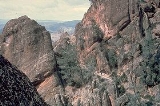
The Monument is divided by the rock formations into East and West Divisions, connected by foot trails; there is no through road that connects the east and west entrances to the park. The east side has shade and water, the west has high walls. The rock formations provide for spectacular pinnacles that attract rock climbers
. It is popular with advanced rock climbers due to the many difficult and challenging climbs. The Monument is most often visited in spring or fall because of the intense heat during the summer months.
in 1906, Pinnacles has had several different federal management agencies, ranging from the United States Forest Service
to the General Land Office
and ultimately to the National Park Service. In 1908 President Theodore Roosevelt
created Pinnacles National Monument with the power given him in the Antiquities Act
of 1906 to commemorate the people and organizations instrumental to the creation and early protection of the park. Pinnacles National Monument celebrated its Centennial in 2008 with numerous dedicatory events. The most recent addition to the Pinnacles National Monument was Clinton's Proclamation 7266 that increased the size of the monument by 7900 acres (32 km²) and to include naturally formed caves.
and about 80 miles (128.7 km) south of the San Francisco Bay Area
. The monument is in the southern portion of the Gabilan Range
, part of California's Coast Ranges.
Elevation within the boundaries range from 824 feet (251.2 m) to 3304 feet (1,007.1 m) at the peak of North Chalone Peak.
The climate is Mediterranean
, typical on the Southern and Central California coast. The Santa Lucia Mountains
lie between the Monument and Pacific Ocean, blocking much of the moderating influence of the Ocean. In comparison to the nearby coast, temperatures have a daily larger range that can be 50 °F to 100 °F (10 °C to 38 °C). The average rainfall is about 16 inches (406.4 mm) per year. Snow can fall in small amounts at higher elevations between mid-December and January.
The National Weather Service
has a cooperative weather station at the park headquarters. Average January temperatures are a maximum of 60.8 °F (16 °C) and a minimum of 32.8 °F (0.444444444447981 °C). Average July temperatures are a maximum of 95.5 °F (35.3 °C) and a minimum of 50.3 °F (10.2 °C). The record high temperature was 116 °F (46.7 °C) on July 15, 1972. The record low temperature was 10 °F (-12.2 °C) on January 2, 1960, and December 22, 1990. Average annual precipitation is 16.55 inches (420.4 mm). The wettest year was 1983 with 35.8 inches (909.3 mm) and the driest year was 1947 with 6.08 inches (154.4 mm). The most precipitation in one month was 10.56 inches (268.2 mm) in March 1983. The most precipitation in 24 hours was 4.74 inches (120.4 mm) on February 3, 1998. The most snowfall in one month was 7 inches (177.8 mm) in January 1962.
The monument lies within the California interior chaparral and woodlands
ecoregion
. The vegetation is about 80% chaparral
with woodland
s, riparian and grassland
s merged into the chaparral. The diversity of intersecting ecosystems and altitude has led to great number of animal species that call the Monument home.
, which had a hand in creating the unique formations the Monument protects. The Pinnacles are part of the Neenach Volcano
which erupted 23 million years ago near what is Lancaster
, California today. The movement of the Pacific Plate
along the San Andreas Fault split a section of rock off from the main body of the volcano and moved it 195 miles (313.8 km) to the northwest. It is believed that the pinnacles came from this particular volcano due to the unique breccia
s that are only found elsewhere in the Neenach Volcano formations. Differential erosion and weathering of the exposed rock created the Pinnacles that are seen today.
Large scale earth movement also created the talus
caves that can be found in the Monument. Deep, narrow gorges and shear fractures were transformed into caves by large chunks of rock falling from above and wedging into the cracks leaving an open area below.
Since the Pinnacles were moved to this area, the San Andreas Fault has shifted 4 miles (6.4 km) to the East of the Monument. The original location of the San Andreas can be seen in the Chalone Creek Fault. Two other large faults are known to run through the Monument, the Miner's Gulch and Pinnacles Faults. These faults parallel the San Andreas and were most likely caused by major movements of the main fault.
Seismic
activity is frequent in the Monument and United States Geological Survey
maintains two seismometer
s within the boundaries. Evidence of past and ongoing seismic activity can be seen in offset streams where they cross faults. Valley bottoms and terraces show signs of uplift.
s breed in this area in some of the highest densities of anywhere in North America. Peregrine falcons have recently returned to the Monument to breed also, but in far fewer numbers. A California Condor
re-establishment program has been in place since 2003. Bobcat
s, mountain lions, coyotes, California Quail
, Wild Turkeys, and many other bird
s and mammal
s live in the area. Like many parks in central California, Pinnacles has had a small problem with wild pigs
(a mix of feral domestic pig
s and imported wild boars) disturbing the landscape on a regular basis. As of Spring 2006, the core of the park was pig free. The culmination of a twenty-year, 1.6 million dollar effort had succeeded in eradicating pigs from the main area of the park. National Park Service
personnel along with IWS worked to remove pigs from inside the park, and establish and monitor an exclusionary pig fence that runs for approximately 26 miles (41.8 km) around the center core of the park. Outside this fence however, wild pigs still roam in regular abundance in and around the federally maintained campground within the east side of park. Such is the pervasiveness of the problem. Current monitoring for potential breaks and breaches in the fence is needed to ensure that the pigs do not return to devastate the park.
. The United States Congress
in 1976 enacted Public Law
94-567, adding Pinnacles Wilderness and several others to the National Wilderness Preservation System
.
 Pinnacles NM includes a well known hiking portion known among enthusiasts simply as "The Pig Fence". This portion of South Wilderness Trail is a challenging stretch of strenuous hiking that at times requires use of the fence, erected to prevent feral pigs from entering the park, to help oneself to climb the steeply pitched trail.
Other trails include lush wildflower accented views along flat stream beds, trails that bring one into beautiful caves, and trails that involve high vistas of the Pinnacle formations.
Salinas Valley
The Salinas Valley lies south of San Francisco, California.The word "salina" is spanish for salt marsh, salt lake or salt pan.-Geography:The Salinas Valley runs approximately south-east from Salinas towards King City. The valley lends its name to the geologic province in which it's located, the...
, just miles from the town of Soledad. The Monument's namesakes are the eroded
Erosion
Erosion is when materials are removed from the surface and changed into something else. It only works by hydraulic actions and transport of solids in the natural environment, and leads to the deposition of these materials elsewhere...
leftovers of half of an extinct volcano
Volcano
2. Bedrock3. Conduit 4. Base5. Sill6. Dike7. Layers of ash emitted by the volcano8. Flank| 9. Layers of lava emitted by the volcano10. Throat11. Parasitic cone12. Lava flow13. Vent14. Crater15...
.
The Monument is divided by the rock formations into East and West Divisions, connected by foot trails; there is no through road that connects the east and west entrances to the park. The east side has shade and water, the west has high walls. The rock formations provide for spectacular pinnacles that attract rock climbers
Rock climbing
Rock climbing also lightly called 'The Gravity Game', is a sport in which participants climb up, down or across natural rock formations or artificial rock walls. The goal is to reach the summit of a formation or the endpoint of a pre-defined route without falling...
. It is popular with advanced rock climbers due to the many difficult and challenging climbs. The Monument is most often visited in spring or fall because of the intense heat during the summer months.
History
First set aside as Pinnacles Forest ReservePinnacles National Forest
Pinnacles National Forest was established as the Pinnacles Forest Reserve by the U.S. Forest Service in California on July 18, 1906 with . It became a National Forest on March 4, 1907. On July 1, 1908 Pinnacles was added to Monterey National Forest and the name was discontinued...
in 1906, Pinnacles has had several different federal management agencies, ranging from the United States Forest Service
United States Forest Service
The United States Forest Service is an agency of the United States Department of Agriculture that administers the nation's 155 national forests and 20 national grasslands, which encompass...
to the General Land Office
General Land Office
The General Land Office was an independent agency of the United States government responsible for public domain lands in the United States. It was created in 1812 to take over functions previously conducted by the United States Department of the Treasury...
and ultimately to the National Park Service. In 1908 President Theodore Roosevelt
Theodore Roosevelt
Theodore "Teddy" Roosevelt was the 26th President of the United States . He is noted for his exuberant personality, range of interests and achievements, and his leadership of the Progressive Movement, as well as his "cowboy" persona and robust masculinity...
created Pinnacles National Monument with the power given him in the Antiquities Act
Antiquities Act
The Antiquities Act of 1906, officially An Act for the Preservation of American Antiquities , is an act passed by the United States Congress and signed into law by Theodore Roosevelt on June 8, 1906, giving the President of the United States authority to, by executive order, restrict the use of...
of 1906 to commemorate the people and organizations instrumental to the creation and early protection of the park. Pinnacles National Monument celebrated its Centennial in 2008 with numerous dedicatory events. The most recent addition to the Pinnacles National Monument was Clinton's Proclamation 7266 that increased the size of the monument by 7900 acres (32 km²) and to include naturally formed caves.
Geography and Climate
Pinnacles NM lies about 40 miles (64.4 km) inland from the Pacific OceanPacific Ocean
The Pacific Ocean is the largest of the Earth's oceanic divisions. It extends from the Arctic in the north to the Southern Ocean in the south, bounded by Asia and Australia in the west, and the Americas in the east.At 165.2 million square kilometres in area, this largest division of the World...
and about 80 miles (128.7 km) south of the San Francisco Bay Area
San Francisco Bay Area
The San Francisco Bay Area, commonly known as the Bay Area, is a populated region that surrounds the San Francisco and San Pablo estuaries in Northern California. The region encompasses metropolitan areas of San Francisco, Oakland, and San Jose, along with smaller urban and rural areas...
. The monument is in the southern portion of the Gabilan Range
Gabilan Range
The Gabilan Range or Gabilan Mountains are located on the Pacific Coast Range of California's Central Coast trending in a northwest-southeast direction along the Monterey County and San Benito County line. It is bordered by the Diablo Range, the San Andreas Fault, and State Route 25 to the east and...
, part of California's Coast Ranges.
Elevation within the boundaries range from 824 feet (251.2 m) to 3304 feet (1,007.1 m) at the peak of North Chalone Peak.
The climate is Mediterranean
Mediterranean climate
A Mediterranean climate is the climate typical of most of the lands in the Mediterranean Basin, and is a particular variety of subtropical climate...
, typical on the Southern and Central California coast. The Santa Lucia Mountains
Santa Lucia Mountains
The Santa Lucia Mountains or Santa Lucia Range is a mountain range in coastal California, running from Monterey southeast for 105 miles to San Luis Obispo. The highest summit is Junipero Serra Peak, in Monterey County...
lie between the Monument and Pacific Ocean, blocking much of the moderating influence of the Ocean. In comparison to the nearby coast, temperatures have a daily larger range that can be 50 °F to 100 °F (10 °C to 38 °C). The average rainfall is about 16 inches (406.4 mm) per year. Snow can fall in small amounts at higher elevations between mid-December and January.
The National Weather Service
National Weather Service
The National Weather Service , once known as the Weather Bureau, is one of the six scientific agencies that make up the National Oceanic and Atmospheric Administration of the United States government...
has a cooperative weather station at the park headquarters. Average January temperatures are a maximum of 60.8 °F (16 °C) and a minimum of 32.8 °F (0.444444444447981 °C). Average July temperatures are a maximum of 95.5 °F (35.3 °C) and a minimum of 50.3 °F (10.2 °C). The record high temperature was 116 °F (46.7 °C) on July 15, 1972. The record low temperature was 10 °F (-12.2 °C) on January 2, 1960, and December 22, 1990. Average annual precipitation is 16.55 inches (420.4 mm). The wettest year was 1983 with 35.8 inches (909.3 mm) and the driest year was 1947 with 6.08 inches (154.4 mm). The most precipitation in one month was 10.56 inches (268.2 mm) in March 1983. The most precipitation in 24 hours was 4.74 inches (120.4 mm) on February 3, 1998. The most snowfall in one month was 7 inches (177.8 mm) in January 1962.
The monument lies within the California interior chaparral and woodlands
California interior chaparral and woodlands
The California interior chaparral and woodlands ecoregion covers in an elliptical ring around the California Central Valley. It occurs on hills and mountains ranging from to . It is part of the Mediterranean forests, woodlands, and scrub biome, with cool, wet winters and hot, dry summers...
ecoregion
Ecoregion
An ecoregion , sometimes called a bioregion, is an ecologically and geographically defined area that is smaller than an ecozone and larger than an ecosystem. Ecoregions cover relatively large areas of land or water, and contain characteristic, geographically distinct assemblages of natural...
. The vegetation is about 80% chaparral
Chaparral
Chaparral is a shrubland or heathland plant community found primarily in the U.S. state of California and in the northern portion of the Baja California peninsula, Mexico...
with woodland
Woodland
Ecologically, a woodland is a low-density forest forming open habitats with plenty of sunlight and limited shade. Woodlands may support an understory of shrubs and herbaceous plants including grasses. Woodland may form a transition to shrubland under drier conditions or during early stages of...
s, riparian and grassland
Grassland
Grasslands are areas where the vegetation is dominated by grasses and other herbaceous plants . However, sedge and rush families can also be found. Grasslands occur naturally on all continents except Antarctica...
s merged into the chaparral. The diversity of intersecting ecosystems and altitude has led to great number of animal species that call the Monument home.
Geology
The Monument is located near the San Andreas FaultSan Andreas Fault
The San Andreas Fault is a continental strike-slip fault that runs a length of roughly through California in the United States. The fault's motion is right-lateral strike-slip...
, which had a hand in creating the unique formations the Monument protects. The Pinnacles are part of the Neenach Volcano
Neenach Volcano
Neenach Volcano is an extinct Miocene volcano in the Coastal Ranges of California. The volcano was split by a fault in the San Andreas fault system and over the last 23 million years the two halves of the volcano have moved about 200 miles apart....
which erupted 23 million years ago near what is Lancaster
Lancaster, California
Lancaster is a charter city in northern Los Angeles County, in the high desert, near the Kern County line. Lancaster currently ranks as the 30th largest city in California, and the 148th largest city in the United States. Lancaster is the principal city within the Antelope Valley...
, California today. The movement of the Pacific Plate
Pacific Plate
The Pacific Plate is an oceanic tectonic plate that lies beneath the Pacific Ocean. At 103 million square kilometres, it is the largest tectonic plate....
along the San Andreas Fault split a section of rock off from the main body of the volcano and moved it 195 miles (313.8 km) to the northwest. It is believed that the pinnacles came from this particular volcano due to the unique breccia
Breccia
Breccia is a rock composed of broken fragments of minerals or rock cemented together by a fine-grained matrix, that can be either similar to or different from the composition of the fragments....
s that are only found elsewhere in the Neenach Volcano formations. Differential erosion and weathering of the exposed rock created the Pinnacles that are seen today.
Large scale earth movement also created the talus
Scree
Scree, also called talus, is a term given to an accumulation of broken rock fragments at the base of crags, mountain cliffs, or valley shoulders. Landforms associated with these materials are sometimes called scree slopes or talus piles...
caves that can be found in the Monument. Deep, narrow gorges and shear fractures were transformed into caves by large chunks of rock falling from above and wedging into the cracks leaving an open area below.
Since the Pinnacles were moved to this area, the San Andreas Fault has shifted 4 miles (6.4 km) to the East of the Monument. The original location of the San Andreas can be seen in the Chalone Creek Fault. Two other large faults are known to run through the Monument, the Miner's Gulch and Pinnacles Faults. These faults parallel the San Andreas and were most likely caused by major movements of the main fault.
Seismic
Seismology
Seismology is the scientific study of earthquakes and the propagation of elastic waves through the Earth or through other planet-like bodies. The field also includes studies of earthquake effects, such as tsunamis as well as diverse seismic sources such as volcanic, tectonic, oceanic,...
activity is frequent in the Monument and United States Geological Survey
United States Geological Survey
The United States Geological Survey is a scientific agency of the United States government. The scientists of the USGS study the landscape of the United States, its natural resources, and the natural hazards that threaten it. The organization has four major science disciplines, concerning biology,...
maintains two seismometer
Seismometer
Seismometers are instruments that measure motions of the ground, including those of seismic waves generated by earthquakes, volcanic eruptions, and other seismic sources...
s within the boundaries. Evidence of past and ongoing seismic activity can be seen in offset streams where they cross faults. Valley bottoms and terraces show signs of uplift.
Wildlife
Prairie FalconPrairie Falcon
The Prairie Falcon is a medium-sized falcon of western North America.It is about the size of a Peregrine Falcon or a crow, with an average length of 40 cm , wingspan of 1 metre , and weight of 720 g...
s breed in this area in some of the highest densities of anywhere in North America. Peregrine falcons have recently returned to the Monument to breed also, but in far fewer numbers. A California Condor
California Condor
The California Condor is a New World vulture, the largest North American land bird. Currently, this condor inhabits only the Grand Canyon area, Zion National Park, and coastal mountains of central and southern California and northern Baja California...
re-establishment program has been in place since 2003. Bobcat
Bobcat
The bobcat is a North American mammal of the cat family Felidae, appearing during the Irvingtonian stage of around 1.8 million years ago . With twelve recognized subspecies, it ranges from southern Canada to northern Mexico, including most of the continental United States...
s, mountain lions, coyotes, California Quail
California Quail
The California Quail, Callipepla californica, also known as the California Valley Quail or Valley Quail, is a small ground-dwelling bird in the New World quail family...
, Wild Turkeys, and many other bird
Bird
Birds are feathered, winged, bipedal, endothermic , egg-laying, vertebrate animals. Around 10,000 living species and 188 families makes them the most speciose class of tetrapod vertebrates. They inhabit ecosystems across the globe, from the Arctic to the Antarctic. Extant birds range in size from...
s and mammal
Mammal
Mammals are members of a class of air-breathing vertebrate animals characterised by the possession of endothermy, hair, three middle ear bones, and mammary glands functional in mothers with young...
s live in the area. Like many parks in central California, Pinnacles has had a small problem with wild pigs
PIGS
PIGS is a four letter acronym that can stand for:* PIGS , Phosphatidylinositol glycan anchor biosynthesis, class S, a human gene* PIGS , the economies of Portugal, Italy , Greece and Spain...
(a mix of feral domestic pig
Domestic pig
The domestic pig is a domesticated animal that traces its ancestry to the wild boar, and is considered a subspecies of the wild boar or a distinct species in its own right. It is likely the wild boar was domesticated as early as 13,000 BC in the Tigris River basin...
s and imported wild boars) disturbing the landscape on a regular basis. As of Spring 2006, the core of the park was pig free. The culmination of a twenty-year, 1.6 million dollar effort had succeeded in eradicating pigs from the main area of the park. National Park Service
National Park Service
The National Park Service is the U.S. federal agency that manages all national parks, many national monuments, and other conservation and historical properties with various title designations...
personnel along with IWS worked to remove pigs from inside the park, and establish and monitor an exclusionary pig fence that runs for approximately 26 miles (41.8 km) around the center core of the park. Outside this fence however, wild pigs still roam in regular abundance in and around the federally maintained campground within the east side of park. Such is the pervasiveness of the problem. Current monitoring for potential breaks and breaches in the fence is needed to ensure that the pigs do not return to devastate the park.
Pinnacles Wilderness
More than 80% of the park is designated as the Pinnacles Wilderness area (15985 acres or 6,468.9 ha), which provides even higher protection for the rock spires that give Pinnacles its name, as well as Chalone Peak, the highest peak in the Gabilan Range, and includes the creeks and canyons that are habitat for the endangered red-legged frogRed-legged Frog
The Red-legged Frog, a threatened native species in Oregon, is a common name for a particular kind of frog of the west coast of North America. The Red-legged Frog requires stream side, woodland environments for survival...
. The United States Congress
United States Congress
The United States Congress is the bicameral legislature of the federal government of the United States, consisting of the Senate and the House of Representatives. The Congress meets in the United States Capitol in Washington, D.C....
in 1976 enacted Public Law
Public law
Public law is a theory of law governing the relationship between individuals and the state. Under this theory, constitutional law, administrative law and criminal law are sub-divisions of public law...
94-567, adding Pinnacles Wilderness and several others to the National Wilderness Preservation System
National Wilderness Preservation System
The National Wilderness Preservation System of the United States protects federally managed land areas designated for preservation in their natural condition. It was established by the Wilderness Act upon the signature of President Lyndon B. Johnson on September 3, 1964...
.
Activities
There are several trails for day hikers, some of which are strenuous. The trails provide views of the surrounding hills and valleys on clear days. The San Andreas Fault is visible from some vantages along the trails.Other trails include lush wildflower accented views along flat stream beds, trails that bring one into beautiful caves, and trails that involve high vistas of the Pinnacle formations.
See also
- State Route 25California State Route 25State Route 25 is a state highway in the U.S. state of California between Gilroy and State Route 198. This route is part of the California Freeway and Expressway System and is eligible for the State Scenic Highway System.-Route description:...
- State Route 146California State Route 146State Route 146 is a state highway in the U.S. state of California in Monterey and San Benito Counties. The route serves as an entryway to the Pinnacles National Monument, located in the Gabilan Mountains, from both the Salinas Valley on the west and State Route 25 on the east.This route is...
- Tres Pinos, CaliforniaTres Pinos, CaliforniaTres Pinos is a census-designated place in San Benito County, California. The community lies along State Route 25, approximately 4 miles south of Hollister and 5 miles north of Paicines. Tres Pinos sits at an elevation of...
- Trona PinnaclesTrona PinnaclesTrona PinnaclesDesignationNational Natural LandmarkLocationCaliforniaNearest CityTrona, CaliforniaCoordinatesArea Date of Establishment1968Governing BodyBureau of Land Management...
— in southern California near RidgecrestRidgecrest, CaliforniaRidgecrest, formerly known as Crumville, was incorporated as a city in 1913. It is located in the Indian Wells Valley in northeastern Kern County, California, adjacent to the Naval Air Weapons Station China Lake . Ridgecrest is the only incorporated city along US 395 in Kern County...
and TronaTrona, CaliforniaTrona is an unincorporated community in San Bernardino County, California. In 2000 it had a population of 2,742. Trona is at the western edge of Searles Lake, a dry lake bed in Searles Valley, southwest of Death Valley. The town takes its name from the mineral trona, abundant in the lakebed.It is...
.