

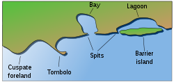
Barrier island
Encyclopedia
Padre Island
Padre Island is part of the U.S. state of Texas. The island is located on Texas' southern coast of the Gulf of Mexico and is famous for its white sandy beaches at the south end...
. The length and width of barriers and overall morphology of barrier coasts are related to parameters including tidal range
Tidal range
The tidal range is the vertical difference between the high tide and the succeeding low tide. Tides are the rise and fall of sea levels caused by the combined effects of the gravitational forces exerted by the Moon and the Sun and the rotation of the Earth...
, wave energy, sediment supply
Sediment transport
Sediment transport is the movement of solid particles , typically due to a combination of the force of gravity acting on the sediment, and/or the movement of the fluid in which the sediment is entrained...
, sea-level trends
Sea level
Mean sea level is a measure of the average height of the ocean's surface ; used as a standard in reckoning land elevation...
and basement controls
Seabed
The seabed is the bottom of the ocean.- Ocean structure :Most of the oceans have a common structure, created by common physical phenomena, mainly from tectonic movement, and sediment from various sources...
.
Chains of barrier islands can be found along approximately thirteen percent of the world's coastlines, some displaying different settings, suggesting that they can form and be maintained in a variety of environmental settings. Numerous theories have been given to explain their formations.
Formation
However, there are some general requirements for formation. Barrier island systems develop most easily on wave dominated coasts with a small to moderate tidal range. Coasts are classified into three groups based on tidal range: microtidal, 0-2 meter tidal range; mesotidal, 2-4 meter tidal range; and macrotidal, >4 meter tidal range. Barrier islands tend to form most dominantly along microtidal coasts, where they tend to be well developed and nearly continuous. They are less frequently formed in mesotidal coasts, where they are typically short with tidal inlets common. Barrier islands are very rare along macrotidal coasts. Along with a small tidal range and a wave-dominated coast, there must be a relatively low gradient shelf. Otherwise, sand accumulation into a sandbar would not occur and instead be dispersed throughout the shore. An ample sediment supply is also a requirement for barrier island formation. The last major requirement for barrier island formation is a stable sea level. It is especially important for sea level to remain relatively unchanged during barrier island formation and growth. If sea level changes are too drastic, there will not be enough time for wave action to accumulate sand into a dune, which will eventually become a barrier island through aggradation. Barrier islands need the sea level to remain constant so that waves can concentrate the sand into one location.
Offshore bar theory
One of the earliest ideas to explain barrier island formation was published in 1845 by the Frenchman Elie de Beaumont. He believed that waves moving into shallow water churned up sand, which was deposited in the form of a submarine barBar (landform)
A shoal, sandbar , or gravelbar is a somewhat linear landform within or extending into a body of water, typically composed of sand, silt or small pebbles. A spit or sandspit is a type of shoal...
when the waves broke and lost much of their energy. As the bars accreted vertically, they gradually built above sea level, forming barrier islands.
Spit accretion theory
American geologist Grove Karl GilbertGrove Karl Gilbert
Grove Karl Gilbert , known by the abbreviated name G. K. Gilbert in academic literature, was an American geologist....
first argued in 1885 the barrier sediments came from longshore sources. He proposed that sediment moving in the breaker zone through agitation by waves in longshore drift
Longshore drift
Longshore drift consists of the transportation of sediments along a coast at an angle to the shoreline, which is dependent on prevailing wind direction, swash and backwash. This process occurs in the littoral zone, and in or within close proximity to the surf zone...
would construct spits
Spit (landform)
A spit or sandspit is a deposition landform found off coasts. At one end, spits connect to land, and extend into the sea. A spit is a type of bar or beach that develops where a re-entrant occurs, such as at cove's headlands, by the process of longshore drift...
extending from headlands parallel to the coast. The subsequent breaching of spits by storm waves would form barrier islands.
Submergence theory
William John McGee reasoned in 1890 that the EastEast Coast of the United States
The East Coast of the United States, also known as the Eastern Seaboard, refers to the easternmost coastal states in the United States, which touch the Atlantic Ocean and stretch up to Canada. The term includes the U.S...
and Gulf coasts
Gulf Coast of the United States
The Gulf Coast of the United States, sometimes referred to as the Gulf South, South Coast, or 3rd Coast, comprises the coasts of American states that are on the Gulf of Mexico, which includes Texas, Louisiana, Mississippi, Alabama, and Florida and are known as the Gulf States...
of the United States
United States
The United States of America is a federal constitutional republic comprising fifty states and a federal district...
were undergoing submergence, as evidenced by the many drowned river valleys that occur along these coasts, including Raritan
Raritan Bay
Raritan Bay is a bay located at the southern portion of Lower New York Bay between the U.S. states of New York and New Jersey and is part of the New York Bight. The bay is bounded on the northwest by New York's Staten Island, on the west by Perth Amboy, New Jersey, on the south by the Raritan...
, Delaware
Delaware Bay
Delaware Bay is a major estuary outlet of the Delaware River on the Northeast seaboard of the United States whose fresh water mixes for many miles with the waters of the Atlantic Ocean. It is in area. The bay is bordered by the State of New Jersey and the State of Delaware...
and Chesapeake
Chesapeake Bay
The Chesapeake Bay is the largest estuary in the United States. It lies off the Atlantic Ocean, surrounded by Maryland and Virginia. The Chesapeake Bay's drainage basin covers in the District of Columbia and parts of six states: New York, Pennsylvania, Delaware, Maryland, Virginia, and West...
Bays. He believed that during submergence coastal ridges were separated from the mainland, forming lagoons behind the ridges. He used the Mississippi-Alabama barrier islands (consists of Cat
Cat Island (Mississippi)
Cat Island is a barrier island off the Gulf Coast of the United States. The island is named for raccoons which Spanish explorers mistook for cats. It is unknown who discovered Cat Island. It was called Isle-aux-Chats and Isola de Gati in French and Italian, respectively. It is within the...
, Ship
Ship Island (Mississippi)
Ship Island is the collective name for two barrier islands off the Gulf Coast of Mississippi, part of Gulf Islands National Seashore: East Ship Island and West Ship Island. Hurricane Camille split the once single island into 2 separate islands in 1969...
, Horn
Horn Island (Mississippi)
Horn Island is a long, thin barrier island off the Gulf Coast of Mississippi, south of Ocean Springs. It is part of the Gulf Islands National Seashore. Horn Island is several miles long, but less than a mile wide at its widest point...
, Petit Bois
Petit Bois Island (Mississippi)
Petit Bois Island is an island off the coast of the U.S. state of Mississippi, south of Pascagoula. It is part of Jackson County, Mississippi. Since 1971 it has been a part of Gulf Islands National Seashore, administered by the U.S. National Park Service....
and Dauphin Islands) as an example where coastal submergence formed barrier islands, but his interpretation was later shown to be incorrect as the coastal stratigraphy and sediment ages were more accurately determined.
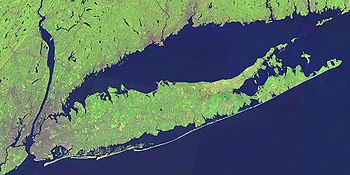
Along the coast of Louisiana
Louisiana
Louisiana is a state located in the southern region of the United States of America. Its capital is Baton Rouge and largest city is New Orleans. Louisiana is the only state in the U.S. with political subdivisions termed parishes, which are local governments equivalent to counties...
former lobes of the Mississippi River
Mississippi River
The Mississippi River is the largest river system in North America. Flowing entirely in the United States, this river rises in western Minnesota and meanders slowly southwards for to the Mississippi River Delta at the Gulf of Mexico. With its many tributaries, the Mississippi's watershed drains...
delta have been reworked by wave action, forming beach ridge complexes. Prolonged sinking of the marshes behind the barriers has converted these former vegetated wetlands to open-water areas. In a period of 125 years, from 1853 to 1978, two small semi-protected bays behind the barrier had been transforming to the large water body of Lake Pelto, leading to Isles Dernieres's detachment from the mainland.
The Boulder Bank
An unusual natural structure in New ZealandNew Zealand
New Zealand is an island country in the south-western Pacific Ocean comprising two main landmasses and numerous smaller islands. The country is situated some east of Australia across the Tasman Sea, and roughly south of the Pacific island nations of New Caledonia, Fiji, and Tonga...
may give clues to the formation processes involved in barrier islands. The Boulder Bank
Boulder Bank
The Boulder Bank is a very unusual naturally formed land form in Nelson, New Zealand. It is a 13 kilometre long stretch of rocky substrate which begins at the Mackay Bluff and ends at the Cut of the Nelson Harbour. Haulashore Island was once apart of the Boulder Bank, but after the Cut being made...
, at the entrance to Nelson Haven
Nelson, New Zealand
Nelson is a city on the eastern shores of Tasman Bay, and is the economic and cultural centre of the Nelson-Tasman region. Established in 1841, it is the second oldest settled city in New Zealand and the oldest in the South Island....
at the northern end of the South Island
South Island
The South Island is the larger of the two major islands of New Zealand, the other being the more populous North Island. It is bordered to the north by Cook Strait, to the west by the Tasman Sea, to the south and east by the Pacific Ocean...
, is a unique 13 kilometer-long stretch of rocky substrate a few metres in width. It is not strictly a barrier island itself, as it is linked to the mainland at one end. The Boulder Bank is composed of granodiorite
Granodiorite
Granodiorite is an intrusive igneous rock similar to granite, but containing more plagioclase than orthoclase-type feldspar. Officially, it is defined as a phaneritic igneous rock with greater than 20% quartz by volume where at least 65% of the feldspar is plagioclase. It usually contains abundant...
from Mackay Bluff, which lies close to the point where the bank joins the mainland. It is still debated what process or processes have resulted in this odd structure, though longshore drift is the most accepted hypothesis. Studies have been conducted since 1892 to determine speed of boulder movement. Rates of the top course gravel movement have been estimated at 7.5 metres a year.
Ecological importance
Barrier islands play an enormous role in mitigating ocean swells and other storm events for the water systems behind on the mainland side of the barrier island. This effectively creates a unique environment of relatively low energy, Brackish waterBrackish water
Brackish water is water that has more salinity than fresh water, but not as much as seawater. It may result from mixing of seawater with fresh water, as in estuaries, or it may occur in brackish fossil aquifers. The word comes from the Middle Dutch root "brak," meaning "salty"...
. Multiple wetland systems such as lagoons, estuaries, and/or marshes can result from such conditions depending on the surroundings. Without barrier islands, these wetlands could not exist and would be destroyed by daily ocean waves and tides as well as ocean storm events. One of the most prominent examples is that of the Louisiana
Louisiana
Louisiana is a state located in the southern region of the United States of America. Its capital is Baton Rouge and largest city is New Orleans. Louisiana is the only state in the U.S. with political subdivisions termed parishes, which are local governments equivalent to counties...
barrier islands.
See also
- Island weldingIsland weldingIsland welding is a geomorphological term to describe the process of welding sandy barrier islands back on to the mainland. Often the stabilisation of coastal navigation entrances disrupts the sustainability of the island welding process....
- Outer BanksOuter BanksThe Outer Banks is a 200-mile long string of narrow barrier islands off the coast of North Carolina, beginning in the southeastern corner of Virginia Beach on the east coast of the United States....
- New York Barrier Islands
- Texas barrier islandsTexas barrier islandsThe Texas barrier islands are some barrier islands in the Gulf of Mexico at the coast of Texas. The islands attract tourists for activities such as dolphin watching...
- Sea IslandsSea IslandsThe Sea Islands are a chain of tidal and barrier islands on the Atlantic Ocean coast of the United States. They number over 100, and are located between the mouths of the Santee and St. Johns Rivers along the coast of the U.S...