
Painted Rock
Encyclopedia
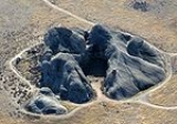
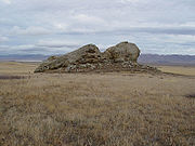
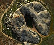
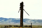
Painted Rock is a smooth horseshoe-shaped marine sandstone
rock formation with pictograph rock art
about 250 feet across and 45 feet tall near Soda Lake
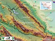
within the Carrizo Plain National Monument on the southwest side of the northern Carrizo Plain
, west of Bakersfield, California
and about 70 miles (112.7 km) east of San Luis Obispo
and 45 miles (72.4 km) west of Taft, California
.
 The interior of the rock alcove is adorned with many pictographs created by the Chumash, Salinan
and Yokut peoples over many thousands of years. In recent times there have been many marks left by early White settlers such as one reading "Geo. Lewis 1908", founder of Atascadero, California
. Unfortunately there has also been major defacing of this site; in the 1920s the large pictogram was irreparably damaged from a shotgun blast.
Ancient rock art in red, black and white yucca pigments, and some yellow, green and blue were painted with rodent tail hair brushes or simple finger painting. Estimates are that the Chumash people first populated the Carrizo Plain about 2000 BCE but mostly abandoned it, possibly due to drought, about CE 600.
The Yokut people common in the nearby San Joaquin Valley
moved in and out of the Carrizo Plain area after the Chumash departed, creating their own rock art. Yokut pictographs often include large colorful figures and motifs, while the Chumash pictographs tend toward small elements, circular mandalas, and complex red, black and white panels.
There is much debate about what group of native peoples lived in this area, as the Salinan, Yokut and Chumash peoples all lay claim to it. The rock art at Painted Rock is inferred to have been produce in shamanic tradition or ritual. The meanings of the symbols have many interpretations but can only be inferred. Ongoing literature discussion speculates that the imagery was produced in association with shamanic trance and hallucination. However, the word shaman encompasses a broad range of societal roles filled by very different people across many different cultures. The concept of "shaman" has also evolved into different meanings in modern society.
Spaniards came through the area in the 18th century; rancheros of Portuguese descent left engravings on Painted rock in the late 19th century. The rock art now attract thousands of visitors each year. Unfortunately, heavy graffiti and reckless gunshot damage to the prehistoric rock art was mostly done in the 1920s. Ongoing damage has continued. As a result, the site is now protected by laws, has limited access, and has vigilant surveillance. Although volunteers removed some of the damage in 1991, the extent of destruction is almost overwhelming to observers (often described as a "ruined" heritage site). However, even the modern damage may be evaluated in a historic context by future generations. Ongoing animal burrowing, natural weathering, and erosion are also degrading the site. The Goodwin Education Center is located near Painted Rock and provides environmental education and guided tours. Painted Rock is closed during raptor nesting season (March 1 through July 15). Native Americans still frequently use Painted Rock for ceremonies and other activities.
 Painted Rock can be reached by foot path from the Goodwin Center off Soda Lake Road, which runs northwest-southeast between State Route 166
and State Route 58
. Like most roads within Carrizo Plain, it is unpaved and subject to sudden closure during and after rainy weather. Note that Painted Rock is a protected area and regularly closed to the public between March 1 and the end of May except for guided tours.
 In this wilderness area visitors are advised to carry sufficient fuel, food, water and medical supplies since there are no services and cellphone coverage is sparse. At an elevation of 1900 feet (579.1 m), days can be very hot and nights quite cold. The climate is dry, with most rain falling in winter and annual totals averaging about 6 inches (15.2 cm).
Walking in the Carrizo Plain area can be dangerous due to low humidity, temperature extremes and rattlesnakes; and is also difficult due to tall grass hiding a very irregular ground surface created by the many burrowing mammals including an endangered species of Kangaroo rat
.
 During limited business hours, Visitor Services for the area is provided by the Goodwin Education Center at 805.475-2131 during the months of December through May. In addition to some Painted Rock tours and details, it also provides information and displays regarding threatened and endangered Carrizo Plain wildlife species. These include the San Joaquin Kit Fox, the blunt-nosed leopard lizard, the giant kangaroo rat
, and the San Joaquin antelope squirrel
.
There is also information and history regarding settlement and farming of the area. Outside the new museum are antique farm equipment and machinery on display, along with picnic areas and walking trails.
The main access road to Painted Rock begins at Goodwin Center, and when closed during rains there is usually access here for hiking in. During the limited business hours of Goodwin Center, maps and a BLM Ranger are usually available for more information.
Sandstone
Sandstone is a sedimentary rock composed mainly of sand-sized minerals or rock grains.Most sandstone is composed of quartz and/or feldspar because these are the most common minerals in the Earth's crust. Like sand, sandstone may be any colour, but the most common colours are tan, brown, yellow,...
rock formation with pictograph rock art
Rock art
Rock art is a term used in archaeology for any human-made markings made on natural stone. They can be divided into:*Petroglyphs - carvings into stone surfaces*Pictographs - rock and cave paintings...
about 250 feet across and 45 feet tall near Soda Lake
Soda Lake (San Luis Obispo County)
Soda Lake is a shallow, ephemeral, alkali endorheic lake in the Carrizo Plain in southeastern San Luis Obispo County, California. The lake is located on the southwest side of the northern Carrizo Plain, 103 km east of San Luis Obispo. It can be reached by Soda Lake Road, which runs...
within the Carrizo Plain National Monument on the southwest side of the northern Carrizo Plain
Carrizo Plain
The Carrizo Plain is a large enclosed plain, approximately 50 miles long and up to 15 miles across, in southeastern San Luis Obispo County, California, about 100 miles northwest of Los Angeles, California...
, west of Bakersfield, California
Bakersfield, California
Bakersfield is a city near the southern end of the San Joaquin Valley in Kern County, California. It is roughly equidistant between Fresno and Los Angeles, to the north and south respectively....
and about 70 miles (112.7 km) east of San Luis Obispo
San Luis Obispo, California
San Luis Obispo is a city in California, located roughly midway between San Francisco and Los Angeles on the Central Coast. Founded in 1772 by Spanish Fr. Junipero Serra, San Luis Obispo is one of California’s oldest communities...
and 45 miles (72.4 km) west of Taft, California
Taft, California
Taft is a city in the foothills at the extreme southwestern edge of the San Joaquin Valley, in Kern County, California. Taft is located west-southwest of Bakersfield, at an elevation of 955 feet . The population was 9,327 at the 2010 census...
.
History
Salinan
The Salinan Native Americans lived in what is now the Central Coast of California, in the Salinas Valley. Said to have gone extinct by the Census of 1930, the Salinan Native Americans survived and are now in the process of applying for tribal recognition from the Bureau of Indian Affairs.There...
and Yokut peoples over many thousands of years. In recent times there have been many marks left by early White settlers such as one reading "Geo. Lewis 1908", founder of Atascadero, California
Atascadero, California
Atascadero is a city in San Luis Obispo County, California, about equidistant from San Francisco and Los Angeles on U-S Highway 101. Atascadero is farther inland than most other San Luis Obispo County cities, and as a result, usually experiences warmer, drier summers and cooler winters than...
. Unfortunately there has also been major defacing of this site; in the 1920s the large pictogram was irreparably damaged from a shotgun blast.
Ancient rock art in red, black and white yucca pigments, and some yellow, green and blue were painted with rodent tail hair brushes or simple finger painting. Estimates are that the Chumash people first populated the Carrizo Plain about 2000 BCE but mostly abandoned it, possibly due to drought, about CE 600.
The Yokut people common in the nearby San Joaquin Valley
San Joaquin Valley
The San Joaquin Valley is the area of the Central Valley of California that lies south of the Sacramento – San Joaquin River Delta in Stockton...
moved in and out of the Carrizo Plain area after the Chumash departed, creating their own rock art. Yokut pictographs often include large colorful figures and motifs, while the Chumash pictographs tend toward small elements, circular mandalas, and complex red, black and white panels.
There is much debate about what group of native peoples lived in this area, as the Salinan, Yokut and Chumash peoples all lay claim to it. The rock art at Painted Rock is inferred to have been produce in shamanic tradition or ritual. The meanings of the symbols have many interpretations but can only be inferred. Ongoing literature discussion speculates that the imagery was produced in association with shamanic trance and hallucination. However, the word shaman encompasses a broad range of societal roles filled by very different people across many different cultures. The concept of "shaman" has also evolved into different meanings in modern society.
Spaniards came through the area in the 18th century; rancheros of Portuguese descent left engravings on Painted rock in the late 19th century. The rock art now attract thousands of visitors each year. Unfortunately, heavy graffiti and reckless gunshot damage to the prehistoric rock art was mostly done in the 1920s. Ongoing damage has continued. As a result, the site is now protected by laws, has limited access, and has vigilant surveillance. Although volunteers removed some of the damage in 1991, the extent of destruction is almost overwhelming to observers (often described as a "ruined" heritage site). However, even the modern damage may be evaluated in a historic context by future generations. Ongoing animal burrowing, natural weathering, and erosion are also degrading the site. The Goodwin Education Center is located near Painted Rock and provides environmental education and guided tours. Painted Rock is closed during raptor nesting season (March 1 through July 15). Native Americans still frequently use Painted Rock for ceremonies and other activities.
Access
California State Route 166
State Route 166 is a state highway in the U.S. state of California. It connects the Central Coast to the southern San Joaquin Valley....
and State Route 58
California State Route 58
State Route 58 is an east-west highway across the California Coast Ranges, the southern San Joaquin Valley, the Tehachapi Mountains, which border the southern Sierra Nevada, and the Mojave Desert. It runs between its western terminus near Santa Margarita and its eastern terminus at Barstow...
. Like most roads within Carrizo Plain, it is unpaved and subject to sudden closure during and after rainy weather. Note that Painted Rock is a protected area and regularly closed to the public between March 1 and the end of May except for guided tours.
Walking in the Carrizo Plain area can be dangerous due to low humidity, temperature extremes and rattlesnakes; and is also difficult due to tall grass hiding a very irregular ground surface created by the many burrowing mammals including an endangered species of Kangaroo rat
Giant Kangaroo Rat
The Giant Kangaroo Rat, Dipodomys ingens, is an endangered rodent species endemic to California.-Description:Dipodomys ingens, the Giant Kangaroo Rat, is one of over 20 species of kangaroo rats, which are small members of the rodent family...
.
Goodwin Center and Museum
Giant Kangaroo Rat
The Giant Kangaroo Rat, Dipodomys ingens, is an endangered rodent species endemic to California.-Description:Dipodomys ingens, the Giant Kangaroo Rat, is one of over 20 species of kangaroo rats, which are small members of the rodent family...
, and the San Joaquin antelope squirrel
San Joaquin Antelope Squirrel
The San Joaquin antelope squirrel or Nelson's antelope squirrel.Ammospermophilus nelsoni, is a species of antelope squirrel, in the San Joaquin Valley of the U.S. state of California.-Distribution and habitat:...
.
There is also information and history regarding settlement and farming of the area. Outside the new museum are antique farm equipment and machinery on display, along with picnic areas and walking trails.
The main access road to Painted Rock begins at Goodwin Center, and when closed during rains there is usually access here for hiking in. During the limited business hours of Goodwin Center, maps and a BLM Ranger are usually available for more information.
See also
- Burro Flats Painted CaveBurro Flats Painted CaveBurro Flats Painted Cave is in the Burro Flats area of the Simi Hills, located between the Simi Valley, and West Hills and Bell Canyon, in Ventura County of Southern California, United States. It is a Cave containing Chumash Native American pictographs...
- California Valley Airport
- California Valley, CaliforniaCalifornia Valley, CaliforniaCalifornia Valley is an unincorporated community located in the eastern part of San Luis Obispo County, California, in the northern portion of the Carrizo Plain.Located...
- Carrizo PlainCarrizo PlainThe Carrizo Plain is a large enclosed plain, approximately 50 miles long and up to 15 miles across, in southeastern San Luis Obispo County, California, about 100 miles northwest of Los Angeles, California...
- Chumash Painted Cave State Historic Park, CaliforniaChumash Painted Cave State Historic Park, CaliforniaChumash Painted Cave State Historic Park is a unit in the state park system of California, USA, preserving a small sandstone cave adorned with rock art attributed to the Chumash people. Adjoining the small community of Painted Cave, the site is located about north of California State Route 154...
- Chumash people
- Rock art of the Chumash peopleRock art of the Chumash peopleChumash rock art is a genre of paintings on caves, mountains, cliffs, or other living rock surfaces, created by the Chumash people of southern California. Pictographs and petroglyphs are common through interior California, the rock painting tradition thrived until the 19th century...
- Shalawa Meadow, CaliforniaShalawa Meadow, CaliforniaShalawa Meadow is a seaside meadow used in ancient times as a burial site by the Chumash people, adjoining a once large Chumash community about 5 miles east of Santa Barbara, California in the Coast Village portion of the community of Montecito.-History:The South Coast area of Santa Barbara...