
Newberry National Volcanic Monument
Encyclopedia
Newberry National Volcanic Monument was designated on November 5, 1990, to protect the area around the Newberry Volcano
in the United States. It was created within the boundaries of the Deschutes National Forest
and is managed by the U.S. Forest Service
. It includes 50000 acres (20,234.3 ha) of lakes, lava flows, and spectacular geologic features in central Oregon
.
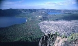
The highest point within the monument is the summit Paulina Peak 7985 ft (2,433.8 m), (2,434 m), with views of the Oregon Cascades
and the high desert
. Paulina Peak may be accessed by road during the summer months, and as the road is both steep and rough, with hairpin turns towards the summit, trailers or long vehicles are discouraged. The summit area of Newberry Volcano holds two alpine
lakes full of trout
, East Lake and Paulina Lake
.
The park is also home to Lava River Cave
, Oregon's longest known lava tube
, just south of Bend
. The cave is easily accessed by U.S. Highway 97 and may be explored by lantern.
Lava Butte
, a 500 feet (152.4 m) cinder cone
, is located next to U.S. Highway 97 south of Bend, next to the Lava Lands Visitor Center. The visitor center is under renovation, and is typically open during the summer.
The monument also features a Lava Cast Forest, which is accessible via a 9 miles (14.5 km) dirt road from U.S. Highway 97.
The Big Obsidian Flow, created 1,300 years ago, covers 700 acres (2.8 km²). The black, shiny obsidian
field is easily accessible from good roads within the caldera, or a trail that traverses the flow.
Newberry Volcano
Newberry Volcano is a large potentially active shield volcano located east of the Cascade Range and about southeast of Bend, Oregon. It is not a typical shield volcano. In addition to erupting basaltic lavas, it also has erupted andesitic and even rhyolitic lava.The volcano is in diameter and...
in the United States. It was created within the boundaries of the Deschutes National Forest
Deschutes National Forest
The Deschutes National Forest is a United States National Forest located in parts of Deschutes, Klamath, Lake, and Jefferson counties in central Oregon. It comprises 1.8 million acres along the east side of the Cascade mountains. In 1908, the Deschutes National Forest was established from parts...
and is managed by the U.S. Forest Service
United States Forest Service
The United States Forest Service is an agency of the United States Department of Agriculture that administers the nation's 155 national forests and 20 national grasslands, which encompass...
. It includes 50000 acres (20,234.3 ha) of lakes, lava flows, and spectacular geologic features in central Oregon
Oregon
Oregon is a state in the Pacific Northwest region of the United States. It is located on the Pacific coast, with Washington to the north, California to the south, Nevada on the southeast and Idaho to the east. The Columbia and Snake rivers delineate much of Oregon's northern and eastern...
.
The highest point within the monument is the summit Paulina Peak 7985 ft (2,433.8 m), (2,434 m), with views of the Oregon Cascades
Cascade Range
The Cascade Range is a major mountain range of western North America, extending from southern British Columbia through Washington and Oregon to Northern California. It includes both non-volcanic mountains, such as the North Cascades, and the notable volcanoes known as the High Cascades...
and the high desert
High Desert (Oregon)
The Oregon High Desert is a region of the U.S. state of Oregon, located east of the Cascade Range and south of the Blue Mountains, in the central and eastern parts of the state. Divided into a southern region and a northern region, the desert covers most of five Oregon counties and averages above...
. Paulina Peak may be accessed by road during the summer months, and as the road is both steep and rough, with hairpin turns towards the summit, trailers or long vehicles are discouraged. The summit area of Newberry Volcano holds two alpine
Alpine climate
Alpine climate is the average weather for a region above the tree line. This climate is also referred to as mountain climate or highland climate....
lakes full of trout
Trout
Trout is the name for a number of species of freshwater and saltwater fish belonging to the Salmoninae subfamily of the family Salmonidae. Salmon belong to the same family as trout. Most salmon species spend almost all their lives in salt water...
, East Lake and Paulina Lake
Paulina Lake
Paulina Lake is one of the twin crater lakes , located above sea level in Newberry Crater, Central Oregon, United States. It is in the Deschutes National Forest near La Pine. The crater was built from 500,000 years of volcanic eruptions. The lake's main inflow is from snow melt, hot springs, and...
.
The park is also home to Lava River Cave
Lava River Cave
The Lava River Cave near Bend, Oregon, is part of the Newberry National Volcanic Monument, which is managed by the United States Forest Service. The cave is an excellent example of a lava tube. At 5,211 feet in length, the northwest section of the cave is the longest continuous lava tube in Oregon...
, Oregon's longest known lava tube
Lava tube
Lava tubes are natural conduits through which lava travels beneath the surface of a lava flow, expelled by a volcano during an eruption. They can be actively draining lava from a source, or can be extinct, meaning the lava flow has ceased and the rock has cooled and left a long, cave-like...
, just south of Bend
Bend, Oregon
Bend is a city in and the county seat of Deschutes County, Oregon, United States, and the principal city of the Bend, Oregon Metropolitan Statistical Area. Bend is Central Oregon's largest city, and, despite its modest size, is the de facto metropolis of the region, owing to the low population...
. The cave is easily accessed by U.S. Highway 97 and may be explored by lantern.
Lava Butte
Lava Butte
Lava Butte is a cinder cone located in central Oregon, USA, just west of US Highway 97 between the towns of Bend, Oregon, and Sunriver, Oregon. It is part of a system of small cinder cones on the northwest flank of Newberry Volcano, a massive shield volcano which rises to the southeast...
, a 500 feet (152.4 m) cinder cone
Cinder cone
According to the , Cinder Cone is the proper name of 1 cinder cone in Canada and 7 cinder cones in the United States:In Canada: Cinder Cone In the United States:...
, is located next to U.S. Highway 97 south of Bend, next to the Lava Lands Visitor Center. The visitor center is under renovation, and is typically open during the summer.
The monument also features a Lava Cast Forest, which is accessible via a 9 miles (14.5 km) dirt road from U.S. Highway 97.
The Big Obsidian Flow, created 1,300 years ago, covers 700 acres (2.8 km²). The black, shiny obsidian
Obsidian
Obsidian is a naturally occurring volcanic glass formed as an extrusive igneous rock.It is produced when felsic lava extruded from a volcano cools rapidly with minimum crystal growth...
field is easily accessible from good roads within the caldera, or a trail that traverses the flow.