

Salt River (Arizona)
Encyclopedia
The Salt River is a stream in the U.S. state
of Arizona
. It is the largest tributary of the Gila River
. The river is about 200 miles (321.9 km) long. Its drainage basin
is about 13700 square miles (35,482.8 km²) large. The longest of the Salt River's many tributaries is the 195 miles (313.8 km) Verde River
. The Salt's headwaters tributaries, the Black River and East Fork, increase the river's total length to about 300 miles (482.8 km).
in the White Mountains
of eastern Gila County
. The White and Black rivers, and other tributaries of the upper Salt River, drain the region between the Mogollon Rim
in the north and the Natanes Mountains and Natanes Plateau to the east and south. Tributaries of the Salt River also drain the Sierra Ancha
and Mazatzal Mountains
. The White and Black rivers drain the White Mountains in the Fort Apache Indian Reservation
. Together the two rivers drain an area of about 1900 square miles (4,921 km²). The Salt River, along with the Black River, forms the boundary between the Fort Apache Indian Reservation to the north and the San Carlos Apache Indian Reservation
to the south.
The Salt River is fed by numerous perennial streams that start as springs and seeps along the Mongollon Rim and in the White Mountains. The Salt River is perennial from its tributary headwaters to Granite Reef Diversion Dam
near Mesa
.
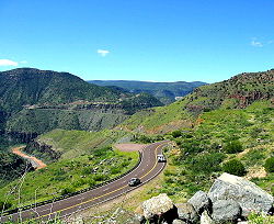
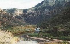
From the Black and White confluence the Salt River flows generally west and southwest. It is joined by Carrizo Creek, a 25 miles (40.2 km) long perennial stream, then flows through the Salt River Canyon. Cibecue Creek, a 36 miles (57.9 km) long perennial stream, joins the river in the canyon, flowing from the north through the Fort Apache Reservation. Between Carrizo and Cibecue Creeks the Salt River becomes the boundary between Tonto National Forest
on the south and the Fort Apache Reservation on the north. Another perennial stream joins from the north, the 46 miles (74 km) long Canyon Creek. Just downstream from the Salt's confluence with Medicine Creek a portion of the Tonto National Forest is designated the Salt River Canyon Wilderness
. The Salt River forms the northern and western boundary of the wilderness for several miles, after which the national forest and wilderness occupy both sides of the river.
 Continuing its westward course the Salt River is joined by Pinal Creek from the south, just before leaving the Salt River Canyon Wilderness. The river continues to flow through Tonto National Forest until leaving the mountains near Mesa. Below the Pinal Creek confluence the Salt River passes through the valley between the Mazatzal Mountains
and Superstition Mountains
and enters Theodore Roosevelt Lake
, the first of four reservoir impoundments on Salt. Tonto Creek joins the Salt River in Theodore Roosevelt Lake. Below Theodore Roosevelt Dam
the Salt River is impounded by Horse Mesa Dam
, forming Apache Lake
, then Mormon Flat Dam
, forming Canyon Lake
, then Stewart Mountain Dam
, forming Saguaro Lake. These four reservoirs are part of the Salt River Project
. The water is used by the Phoenix metropolitan area
for municipal, industrial, and agricultural purposes. The storage capacity of the reservoirs is 2910200 acre.ft for Roosevelt, 245100 acre.ft for Apache, 57900 acre.ft for Canyon, and 69800 acre.ft for Saguaro.
As the Salt River passes through its reservoirs it flows by the Four Peaks Wilderness, near Four Peaks
. A few miles downstream of Stewart Mountain Dam, the last of the four Salt River Project dams, the Verde River
joins the Salt from the north. Fountain Hills is located a few miles to the northwest. The Salt River Pima-Maricopa Indian Community
is located near the Verde-Salt confluence. The Tonto National Forest ends a couple miles below the Verde River confluence and the Salt River enters the eastern edge of the great Phoenix metropolitan area. Less than 0.5 mile (0.80467 km) from the national forest boundary the Granite Reef Diversion Dam
diverts all remaining water in the Salt River into the Arizona Canal
and Southern Canal, which deliver drinking and irrigation water to much of the Phoenix metropolitan area. The dam and canals are part of the Salt River Project. Below the diversion dam the bed of the Salt River is dry, except following rain or upstream runoff. The USGS stream gage at 51st Avenue, Phoenix, records no flow at all on many days—in 2009 for example, there was no flow for most of the year, except during parts of February and March when the river's discharge reached an average of 87 cuft/s. The diversion capacity at Granite Reef Diversion Dam is 3600 cuft/s, with 2000 cuft/s for the Arizona Canal, and 1600 cuft/s for the Southern Canal.
Below Granite Reef Dam the Salt River leaves the mountains and flows past the cities of Mesa
, Tempe
, and Scottsdale
, then south of downtown Phoenix
, where it passes north of South Mountain Park
. With the exception of Tempe Town Lake
, the riverbed winding through the cities is usually dry, except when heavy rains upstream force Stewart Mountain Dam to release more water than can be diverted at Granite Reef Dam. The Salt River joins the Gila on the southwestern edge of Phoenix approximately 15 miles (24.1 km) from the center of the city. Monument Hill overlooks the confluence of rivers and is the site of the Initial Survey point for Arizona, the Gila and Salt River Meridian
.
, dangerous flash floods occasionally occur, especially during monsoon
storms in late July and early August. Flood waters can wash out roads. Bridges have been damaged, notably in 1980, 1993, and 2005. The natural flow of the Salt is 2570 cubic feet per second (cfs) at its mouth. However, except after rainfall, the Salt is dry or a small stream below Granite Reef Dam. The river was formerly navigable throughout its course by small craft. The river is still navigable in the majority of the area where it still carries water.
The river was used for irrigation by Native Americans
and by early European settlers in the 19th century. It currently provides a major source of irrigation and drinking water for Phoenix and surrounding communities through the Salt River Project
. The river's water is distributed over more than 1,000 mi (1,609 km) of irrigation canals, used primarily for the growing of cotton
, alfalfa
, fruit, and vegetables.
problems along many stream reaches in Salt River's watershed, related to rangeland management, recreation, mining, sand & gravels operations, other sources. High levels of fecal coliform bacteria and ammonia have been reported for Carrizo Creek and the White River.
Below Saguaro Lake: Paved and Dirt Access, Live Bait Fish, Swimming, No Motors Allowed, Parking Area, Tables, Restrooms, Camping Allowed - Several camp and picnic areas, Drained in winter
The above facilities are maintained by the Tonto National Forest
.
Tempe Boat Rentals at Tempe Town Lake: Small passenger boats including kayaks, pedal boats, electric powered pontoons and fishing boats. This is an independent contractor and not managed by the City of Tempe. http://boats4rent.com/tempe-boat-rental.html
, smallmouth bass
, sunfish
, channel catfish
, flathead catfish
, carp
Below Saguaro Lake (11 fishable miles): Rainbow trout
, largemouth bass
, smallmouth bass
, yellow bass
, crappie
, sunfish
, channel catfish
, flathead catfish
, walleye
, tilapia
, carp
, bullfrog
s
, the Salt River has also been known as:
U.S. state
A U.S. state is any one of the 50 federated states of the United States of America that share sovereignty with the federal government. Because of this shared sovereignty, an American is a citizen both of the federal entity and of his or her state of domicile. Four states use the official title of...
of Arizona
Arizona
Arizona ; is a state located in the southwestern region of the United States. It is also part of the western United States and the mountain west. The capital and largest city is Phoenix...
. It is the largest tributary of the Gila River
Gila River
The Gila River is a tributary of the Colorado River, 650 miles long, in the southwestern states of New Mexico and Arizona.-Description:...
. The river is about 200 miles (321.9 km) long. Its drainage basin
Drainage basin
A drainage basin is an extent or an area of land where surface water from rain and melting snow or ice converges to a single point, usually the exit of the basin, where the waters join another waterbody, such as a river, lake, reservoir, estuary, wetland, sea, or ocean...
is about 13700 square miles (35,482.8 km²) large. The longest of the Salt River's many tributaries is the 195 miles (313.8 km) Verde River
Verde River
The Verde River is the north and northwestern watershed of the Salt River–Verde River Watershed that co-join and enter the Gila River at Phoenix, Arizona, located in the U.S. state of Arizona...
. The Salt's headwaters tributaries, the Black River and East Fork, increase the river's total length to about 300 miles (482.8 km).
Course
The Salt River is formed by the confluence of the White River and Black RiverBlack River (Arizona)
The Black River is a river in the White Mountains of Arizona, USA, to the west of Alpine. Along with the Whiteriver, it forms the Salt River, a major tributary of the Gila River.It was named by James Ohio Pattie in 1826 as he explored the area....
in the White Mountains
White Mountains (Arizona)
The White Mountains of Arizona are a mountain range and mountainous region in the eastern part of the state, near the border with New Mexico; it is a continuation from the west of the Arizona transition zone–Mogollon Rim, with the Rim ending in western New Mexico...
of eastern Gila County
Gila County, Arizona
-2010:Whereas according to the 2010 U.S. Census Bureau:*76.8% White*0.4% Black*14.8% Native American*0.5% Asian*0.1% Native Hawaiian or Pacific Islander*2.0% Two or more races*5.4% Other races*17.9% Hispanic or Latino -2000:...
. The White and Black rivers, and other tributaries of the upper Salt River, drain the region between the Mogollon Rim
Mogollon Rim
The Mogollon Rim is a topographical and geological feature running across the U.S. state of Arizona. It extends approximately from northern Yavapai County eastward to near the border with New Mexico.-Description:...
in the north and the Natanes Mountains and Natanes Plateau to the east and south. Tributaries of the Salt River also drain the Sierra Ancha
Sierra Ancha
The Sierra Ancha is a mountain range in Gila County, in central Arizona. It lies between Roosevelt Lake to the south, the Tonto Basin to the west, Cherry Creek to the east, and Pleasant Valley to the north...
and Mazatzal Mountains
Mazatzal Mountains
The Mazatzal Mountains are a mountain range in south central Arizona, about 30–45 miles northeast of Phoenix and the Phoenix metropolitan area. The origin of the name remains obscure but one possibility is that it is from the Aztec language meaning "place of the deer"...
. The White and Black rivers drain the White Mountains in the Fort Apache Indian Reservation
Fort Apache Indian Reservation
The Fort Apache Indian Reservation is an Indian reservation in Arizona, United States, encompassing parts of Navajo, Gila, and Apache counties. It is home to the federally recognized White Mountain Apache Tribe of the Fort Apache Reservation, a Western Apache tribe. It has a land area of 2,627.608...
. Together the two rivers drain an area of about 1900 square miles (4,921 km²). The Salt River, along with the Black River, forms the boundary between the Fort Apache Indian Reservation to the north and the San Carlos Apache Indian Reservation
San Carlos Apache Indian Reservation
The San Carlos Apache Indian Reservation, in southeastern Arizona, United States, was established in 1871 as a reservation for the Chiricahua Apache tribe. It was referred to by some as "Hell's Forty Acres," due to a myriad of dismal health and environmental conditions.-Formation:President U.S....
to the south.
The Salt River is fed by numerous perennial streams that start as springs and seeps along the Mongollon Rim and in the White Mountains. The Salt River is perennial from its tributary headwaters to Granite Reef Diversion Dam
Granite Reef Diversion Dam
The Granite Reef Diversion Dam is a concrete diversion dam located Northeast of Phoenix, Arizona, on the Salt River. The dam is long, high and was built between 1906-09 for the Salt River Project, who currently operates the dam....
near Mesa
Mesa, Arizona
According to the 2010 Census, the racial composition of Mesa was as follows:* White: 77.1% * Hispanic or Latino : 26.54%* Black or African American: 3.5%* Two or more races: 3.4%* Native American: 2.4%...
.
From the Black and White confluence the Salt River flows generally west and southwest. It is joined by Carrizo Creek, a 25 miles (40.2 km) long perennial stream, then flows through the Salt River Canyon. Cibecue Creek, a 36 miles (57.9 km) long perennial stream, joins the river in the canyon, flowing from the north through the Fort Apache Reservation. Between Carrizo and Cibecue Creeks the Salt River becomes the boundary between Tonto National Forest
Tonto National Forest
The Tonto National Forest, encompassing 2,873,200 acres , is the largest of the six national forests in Arizona and is the fifth largest national forest in the United States. The Tonto National Forest has diverse scenery, with elevations ranging from 1,400 feet in the Sonoran Desert to 7,400 feet...
on the south and the Fort Apache Reservation on the north. Another perennial stream joins from the north, the 46 miles (74 km) long Canyon Creek. Just downstream from the Salt's confluence with Medicine Creek a portion of the Tonto National Forest is designated the Salt River Canyon Wilderness
Salt River Canyon Wilderness
Salt River Canyon Wilderness is a wilderness area located within the Tonto National Forest in the U.S. state of Arizona.The Salt River and its deep canyon bisect the entire length of the wilderness...
. The Salt River forms the northern and western boundary of the wilderness for several miles, after which the national forest and wilderness occupy both sides of the river.
Mazatzal Mountains
The Mazatzal Mountains are a mountain range in south central Arizona, about 30–45 miles northeast of Phoenix and the Phoenix metropolitan area. The origin of the name remains obscure but one possibility is that it is from the Aztec language meaning "place of the deer"...
and Superstition Mountains
Superstition Mountains
The Superstition Mountains , popularly referred to as "The Superstitions", are a range of mountains in Arizona located to the east of the Phoenix metropolitan area...
and enters Theodore Roosevelt Lake
Theodore Roosevelt Lake
Theodore Roosevelt Lake is a large reservoir formed by Theodore Roosevelt Dam on the Salt River in Arizona as part of the Salt River Project...
, the first of four reservoir impoundments on Salt. Tonto Creek joins the Salt River in Theodore Roosevelt Lake. Below Theodore Roosevelt Dam
Theodore Roosevelt Dam
Theodore Roosevelt Dam is a dam on the Salt River located northeast of Phoenix, Arizona. The dam is high and forms Theodore Roosevelt Lake as it impounds the Salt River. Originally built between 1905 and 1911, the dam was renovated and expanded in 1989-1996. The dam is named after then-President...
the Salt River is impounded by Horse Mesa Dam
Horse Mesa Dam
The Horse Mesa Dam is a concrete thin arch dam located Northeast of Phoenix, Arizona. The dam is long, high and was built between 1924-27. The dam includes three conventional hydroelectric generating units totaling 32 megawatts and a pumped-storage unit with a capacity of 97 MW. The dam forms...
, forming Apache Lake
Apache Lake (Arizona)
Apache Lake is one of four artificial reservoirs created along the Salt River in central Arizona as part of the Salt River Project. The lake is located near the Apache Trail about 65 miles northeast of Phoenix. Apache Lake was formed by Horse Mesa Dam which was completed in 1927...
, then Mormon Flat Dam
Mormon Flat Dam
The Mormon Flat Dam is a dam on the Salt River located Northeast of Phoenix, Arizona. The dam is 380 feet long, 224 feet high and was built between 1923-25. The Dam is named after nearby Mormon Flat, a place where LDS settlers from Utah stopped to camp. There are two hydroelectric generating units...
, forming Canyon Lake
Canyon Lake (Arizona)
Canyon Lake is one of four reservoirs that were formed by the damming of the Salt River in the U.S. state of Arizona.The lake was formed by the Mormon Flat Dam, which was completed in 1925 after two years of construction. Canyon Lake, with a surface area of , is the third and smallest of four lakes...
, then Stewart Mountain Dam
Stewart Mountain Dam
The Stewart Mountain Dam is a concrete thin arch dam located 41 miles northeast of Phoenix, Arizona. The dam is long, high, and was built between 1928-30. The dam includes a 13,000 kilowatt hydroelectric generating unit that is operated by SRP , an Arizona public utility. It is primarily...
, forming Saguaro Lake. These four reservoirs are part of the Salt River Project
Salt River Project
The Salt River Project is the umbrella name for two separate entities: the Salt River Project Agricultural Improvement and Power District, an agency of the state of Arizona that serves as an electrical utility for the Phoenix metropolitan area, and the Salt River Valley Water Users' Association, a...
. The water is used by the Phoenix metropolitan area
Phoenix Metropolitan Area
The Phoenix metropolitan area, often referred to as The Valley of the Sun, is a metropolitan area, centered on the city of Phoenix, that includes much of the central part of the US state of Arizona...
for municipal, industrial, and agricultural purposes. The storage capacity of the reservoirs is 2910200 acre.ft for Roosevelt, 245100 acre.ft for Apache, 57900 acre.ft for Canyon, and 69800 acre.ft for Saguaro.
As the Salt River passes through its reservoirs it flows by the Four Peaks Wilderness, near Four Peaks
Four Peaks
Four Peaks , at in altitude, is a prominent landmark on the eastern skyline of Phoenix, part of the Mazatzal Mountains. It is located in the Tonto National Forest east-northeast of Phoenix, in the Four Peaks Wilderness...
. A few miles downstream of Stewart Mountain Dam, the last of the four Salt River Project dams, the Verde River
Verde River
The Verde River is the north and northwestern watershed of the Salt River–Verde River Watershed that co-join and enter the Gila River at Phoenix, Arizona, located in the U.S. state of Arizona...
joins the Salt from the north. Fountain Hills is located a few miles to the northwest. The Salt River Pima-Maricopa Indian Community
Salt River Pima-Maricopa Indian Community
The Salt River Pima–Maricopa Indian Community comprises two distinct Native American tribes—the Pima and the Maricopa —many of whom were originally of the Halchidhoma tribe. The community was officially created by an Executive Order of US President Rutherford B. Hayes on June 14, 1879...
is located near the Verde-Salt confluence. The Tonto National Forest ends a couple miles below the Verde River confluence and the Salt River enters the eastern edge of the great Phoenix metropolitan area. Less than 0.5 mile (0.80467 km) from the national forest boundary the Granite Reef Diversion Dam
Granite Reef Diversion Dam
The Granite Reef Diversion Dam is a concrete diversion dam located Northeast of Phoenix, Arizona, on the Salt River. The dam is long, high and was built between 1906-09 for the Salt River Project, who currently operates the dam....
diverts all remaining water in the Salt River into the Arizona Canal
Arizona Canal
The Arizona Canal is a major canal in central Maricopa County that led to the founding of several communities, now among the wealthier neighborhoods of suburban Phoenix, in the late 1880s. Flood irrigation of residential yards is still common in these neighborhoods, using a system of lateral...
and Southern Canal, which deliver drinking and irrigation water to much of the Phoenix metropolitan area. The dam and canals are part of the Salt River Project. Below the diversion dam the bed of the Salt River is dry, except following rain or upstream runoff. The USGS stream gage at 51st Avenue, Phoenix, records no flow at all on many days—in 2009 for example, there was no flow for most of the year, except during parts of February and March when the river's discharge reached an average of 87 cuft/s. The diversion capacity at Granite Reef Diversion Dam is 3600 cuft/s, with 2000 cuft/s for the Arizona Canal, and 1600 cuft/s for the Southern Canal.
Below Granite Reef Dam the Salt River leaves the mountains and flows past the cities of Mesa
Mesa, Arizona
According to the 2010 Census, the racial composition of Mesa was as follows:* White: 77.1% * Hispanic or Latino : 26.54%* Black or African American: 3.5%* Two or more races: 3.4%* Native American: 2.4%...
, Tempe
Tempe, Arizona
Tempe is a city in Maricopa County, Arizona, USA, with the Census Bureau reporting a 2010 population of 161,719. The city is named after the Vale of Tempe in Greece. Tempe is located in the East Valley section of metropolitan Phoenix; it is bordered by Phoenix and Guadalupe on the west, Scottsdale...
, and Scottsdale
Scottsdale, Arizona
Scottsdale is a city in the eastern part of Maricopa County, Arizona, United States, adjacent to Phoenix. According to the U.S. Census Bureau, as of 2010 the population of the city was 217,385...
, then south of downtown Phoenix
Phoenix, Arizona
Phoenix is the capital, and largest city, of the U.S. state of Arizona, as well as the sixth most populated city in the United States. Phoenix is home to 1,445,632 people according to the official 2010 U.S. Census Bureau data...
, where it passes north of South Mountain Park
South Mountain Park
South Mountain Park in Phoenix, Arizona, is the largest city park in the United States, one of the largest urban parks in North America and in the world. It has been designated as a Phoenix Point of Pride.-Geography and Ecology:...
. With the exception of Tempe Town Lake
Tempe Town Lake
Tempe Town Lake is a reservoir that occupies a portion of the currently dry riverbed of the Salt River as it passes through the city of Tempe, Arizona just north of Tempe Butte....
, the riverbed winding through the cities is usually dry, except when heavy rains upstream force Stewart Mountain Dam to release more water than can be diverted at Granite Reef Dam. The Salt River joins the Gila on the southwestern edge of Phoenix approximately 15 miles (24.1 km) from the center of the city. Monument Hill overlooks the confluence of rivers and is the site of the Initial Survey point for Arizona, the Gila and Salt River Meridian
Gila and Salt River Meridian
The Gila and Salt River Meridian intersects the base line on the south side of Gila River, opposite the mouth of Salt River, in latitude 33° 22' 40" north, longitude 112° 17' 25" west from Greenwich, and governs the surveys in the territory of Arizona...
.
River modifications
Despite the dry river bed, or arroyoArroyo (creek)
An arroyo , a Spanish word translated as brook, and also called a wash is usually a dry creek or stream bed—gulch that temporarily or seasonally fills and flows after sufficient rain. Wadi is a similar term in Africa. In Spain, a rambla has a similar meaning to arroyo.-Types and processes:Arroyos...
, dangerous flash floods occasionally occur, especially during monsoon
North American Monsoon
The North American monsoon, variously known as the Southwest United States monsoon, the Mexican monsoon, or the Arizona monsoon, is experienced as a pronounced increase in rainfall from an extremely dry June to a rainy July over large areas of the southwestern United States and northwestern Mexico...
storms in late July and early August. Flood waters can wash out roads. Bridges have been damaged, notably in 1980, 1993, and 2005. The natural flow of the Salt is 2570 cubic feet per second (cfs) at its mouth. However, except after rainfall, the Salt is dry or a small stream below Granite Reef Dam. The river was formerly navigable throughout its course by small craft. The river is still navigable in the majority of the area where it still carries water.
The river was used for irrigation by Native Americans
Native Americans in the United States
Native Americans in the United States are the indigenous peoples in North America within the boundaries of the present-day continental United States, parts of Alaska, and the island state of Hawaii. They are composed of numerous, distinct tribes, states, and ethnic groups, many of which survive as...
and by early European settlers in the 19th century. It currently provides a major source of irrigation and drinking water for Phoenix and surrounding communities through the Salt River Project
Salt River Project
The Salt River Project is the umbrella name for two separate entities: the Salt River Project Agricultural Improvement and Power District, an agency of the state of Arizona that serves as an electrical utility for the Phoenix metropolitan area, and the Salt River Valley Water Users' Association, a...
. The river's water is distributed over more than 1,000 mi (1,609 km) of irrigation canals, used primarily for the growing of cotton
Cotton
Cotton is a soft, fluffy staple fiber that grows in a boll, or protective capsule, around the seeds of cotton plants of the genus Gossypium. The fiber is almost pure cellulose. The botanical purpose of cotton fiber is to aid in seed dispersal....
, alfalfa
Alfalfa
Alfalfa is a flowering plant in the pea family Fabaceae cultivated as an important forage crop in the US, Canada, Argentina, France, Australia, the Middle East, South Africa, and many other countries. It is known as lucerne in the UK, France, Australia, South Africa and New Zealand, and known as...
, fruit, and vegetables.
Water quality
There are turbidityTurbidity
Turbidity is the cloudiness or haziness of a fluid caused by individual particles that are generally invisible to the naked eye, similar to smoke in air. The measurement of turbidity is a key test of water quality....
problems along many stream reaches in Salt River's watershed, related to rangeland management, recreation, mining, sand & gravels operations, other sources. High levels of fecal coliform bacteria and ammonia have been reported for Carrizo Creek and the White River.
Recreation on the Salt River
Boating facilities
Cherry Creek to Roosevelt Lake: Paved, Gravel and Trail Access, Live Bait Fish (Restrictions in Effect), No Motors Allowed, Primitive Parking Area, Camping Allowed, Area Mostly InaccessibleBelow Saguaro Lake: Paved and Dirt Access, Live Bait Fish, Swimming, No Motors Allowed, Parking Area, Tables, Restrooms, Camping Allowed - Several camp and picnic areas, Drained in winter
The above facilities are maintained by the Tonto National Forest
Tonto National Forest
The Tonto National Forest, encompassing 2,873,200 acres , is the largest of the six national forests in Arizona and is the fifth largest national forest in the United States. The Tonto National Forest has diverse scenery, with elevations ranging from 1,400 feet in the Sonoran Desert to 7,400 feet...
.
Tempe Boat Rentals at Tempe Town Lake: Small passenger boats including kayaks, pedal boats, electric powered pontoons and fishing boats. This is an independent contractor and not managed by the City of Tempe. http://boats4rent.com/tempe-boat-rental.html
Fish species
Cherry Creek to Roosevelt Lake (15 fishable miles): Largemouth bassLargemouth bass
The largemouth bass is a species of black bass in the sunfish family native to North America . It is also known as widemouth bass, bigmouth, black bass, bucketmouth, Potter's fish, Florida bass, Florida largemouth, green bass, green trout, linesides, Oswego bass, southern largemouth...
, smallmouth bass
Smallmouth bass
The smallmouth bass is a species of freshwater fish in the sunfish family of the order Perciformes. It is the type species of its genus...
, sunfish
Centrarchidae
The sunfishes are a family of freshwater ray-finned fish belonging to the order Perciformes. The type genus is Centrarchus . The family's 27 species includes many fishes familiar to North Americans, including the rock bass, largemouth bass, bluegill, pumpkinseed, and crappies...
, channel catfish
Channel catfish
Channel catfish, Ictalurus punctatus, is North America's most numerous catfish species. It is the official fish of Missouri, Iowa, Nebraska, Kansas, and Tennessee, and is informally referred to as a "channel cat". In the United States they are the most fished catfish species with approximately 8...
, flathead catfish
Flathead catfish
The flathead catfish , also called the yellow cat, opelousas, and shovelhead cat, are large North American freshwater catfish. This is the only species of the genus Pylodictis...
, carp
Carp
Carp are various species of oily freshwater fish of the family Cyprinidae, a very large group of fish native to Europe and Asia. The cypriniformes are traditionally grouped with the Characiformes, Siluriformes and Gymnotiformes to create the superorder Ostariophysi, since these groups have certain...
Below Saguaro Lake (11 fishable miles): Rainbow trout
Rainbow trout
The rainbow trout is a species of salmonid native to tributaries of the Pacific Ocean in Asia and North America. The steelhead is a sea run rainbow trout usually returning to freshwater to spawn after 2 to 3 years at sea. In other words, rainbow trout and steelhead trout are the same species....
, largemouth bass
Largemouth bass
The largemouth bass is a species of black bass in the sunfish family native to North America . It is also known as widemouth bass, bigmouth, black bass, bucketmouth, Potter's fish, Florida bass, Florida largemouth, green bass, green trout, linesides, Oswego bass, southern largemouth...
, smallmouth bass
Smallmouth bass
The smallmouth bass is a species of freshwater fish in the sunfish family of the order Perciformes. It is the type species of its genus...
, yellow bass
Yellow bass
The yellow bass or barfish, Morone mississippiensis, is a freshwater fish native to the south and midwestern United States. Though sometimes confused with white bass or striped bass, it is distinguished by its yellow belly and the broken pattern in its lowermost stripes...
, crappie
Crappie
Crappie is a genus of freshwater fish in the sunfish family of order Perciformes. The type species is P. annularis, the white crappie...
, sunfish
Centrarchidae
The sunfishes are a family of freshwater ray-finned fish belonging to the order Perciformes. The type genus is Centrarchus . The family's 27 species includes many fishes familiar to North Americans, including the rock bass, largemouth bass, bluegill, pumpkinseed, and crappies...
, channel catfish
Channel catfish
Channel catfish, Ictalurus punctatus, is North America's most numerous catfish species. It is the official fish of Missouri, Iowa, Nebraska, Kansas, and Tennessee, and is informally referred to as a "channel cat". In the United States they are the most fished catfish species with approximately 8...
, flathead catfish
Flathead catfish
The flathead catfish , also called the yellow cat, opelousas, and shovelhead cat, are large North American freshwater catfish. This is the only species of the genus Pylodictis...
, walleye
Walleye
Walleye is a freshwater perciform fish native to most of Canada and to the northern United States. It is a North American close relative of the European pikeperch...
, tilapia
Tilapia
Tilapia , is the common name for nearly a hundred species of cichlid fish from the tilapiine cichlid tribe. Tilapia inhabit a variety of fresh water habitats, including shallow streams, ponds, rivers and lakes. Historically, they have been of major importance in artisan fishing in Africa and the...
, carp
Carp
Carp are various species of oily freshwater fish of the family Cyprinidae, a very large group of fish native to Europe and Asia. The cypriniformes are traditionally grouped with the Characiformes, Siluriformes and Gymnotiformes to create the superorder Ostariophysi, since these groups have certain...
, bullfrog
Bullfrog
The American bullfrog , often simply known as the bullfrog in Canada and the United States, is an aquatic frog, a member of the family Ranidae, or “true frogs”, native to much of North America. This is a frog of larger, permanent water bodies, swamps, ponds, and lakes, where it is usually found...
s
Variant names
According to the Geographic Names Information SystemGeographic Names Information System
The Geographic Names Information System is a database that contains name and locative information about more than two million physical and cultural features located throughout the United States of America and its territories. It is a type of gazetteer...
, the Salt River has also been known as:
- Assumption
- Assuption
- Black River
- Blau Fluss
- Blue River
- Rio Asuncion
- Rio Azulrio de Lasrio
- Rio de la Asuncion
- Rio de las Balsas
- River of the Rafts
- Salada
- Salinas
- Rio Salado