

Sonoran Desert
Encyclopedia
North America
North America is a continent wholly within the Northern Hemisphere and almost wholly within the Western Hemisphere. It is also considered a northern subcontinent of the Americas...
n desert
Desert
A desert is a landscape or region that receives an extremely low amount of precipitation, less than enough to support growth of most plants. Most deserts have an average annual precipitation of less than...
which straddles part of the United States-Mexico border and covers large parts of the U.S. state
U.S. state
A U.S. state is any one of the 50 federated states of the United States of America that share sovereignty with the federal government. Because of this shared sovereignty, an American is a citizen both of the federal entity and of his or her state of domicile. Four states use the official title of...
s of Arizona
Arizona
Arizona ; is a state located in the southwestern region of the United States. It is also part of the western United States and the mountain west. The capital and largest city is Phoenix...
and California
California
California is a state located on the West Coast of the United States. It is by far the most populous U.S. state, and the third-largest by land area...
and the northwest Mexican states of Sonora
Sonora
Sonora officially Estado Libre y Soberano de Sonora is one of the 31 states which, with the Federal District, comprise the 32 Federal Entities of Mexico. It is divided into 72 municipalities; the capital city is Hermosillo....
, Baja California
Baja California
Baja California officially Estado Libre y Soberano de Baja California is one of the 31 states which, with the Federal District, comprise the 32 Federal Entities of Mexico. It is both the northernmost and westernmost state of Mexico. Before becoming a state in 1953, the area was known as the North...
, and Baja California Sur
Baja California Sur
Baja California Sur , is one of the 31 states which, with the Federal District, comprise the 32 Federal Entities of Mexico. Before becoming a state on October 8, 1974, the area was known as the South Territory of Baja California. It has an area of , or 3.57% of the land mass of Mexico and comprises...
. It is one of the largest and hottest deserts in North America, with an area of 311000 square kilometres (120,077.8 sq mi). The desert contains a variety of unique plants and animals, such as the saguaro
Saguaro
The saguaro is a large, tree-sized cactus species in the monotypic genus Carnegiea. It is native to the Sonoran Desert in the U.S. state of Arizona, the Mexican state of Sonora, a small part of Baja California in the San Felipe Desert and an extremely small area of California, U.S...
cactus.
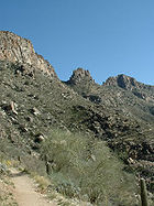
Location
The Sonoran desert wraps around the northern end of the Gulf of CaliforniaGulf of California
The Gulf of California is a body of water that separates the Baja California Peninsula from the Mexican mainland...
, from Baja California Sur
Baja California Sur
Baja California Sur , is one of the 31 states which, with the Federal District, comprise the 32 Federal Entities of Mexico. Before becoming a state on October 8, 1974, the area was known as the South Territory of Baja California. It has an area of , or 3.57% of the land mass of Mexico and comprises...
(El Vizcaíno Biosphere Reserve
El Vizcaíno Biosphere Reserve
The El Vizcaíno Biosphere Reserve, created in 1988, is located in Mulegé Municipality in northern Baja California Sur, at the center of the Baja California Peninsula between the Pacific Ocean and Sea of Cortez...
in central and Pacific west coast, Central Gulf Coast subregion on east to southern tip), north through much of Baja California
Baja California
Baja California officially Estado Libre y Soberano de Baja California is one of the 31 states which, with the Federal District, comprise the 32 Federal Entities of Mexico. It is both the northernmost and westernmost state of Mexico. Before becoming a state in 1953, the area was known as the North...
, excluding the central northwest mountains and Pacific west coast, through southeastern California
California
California is a state located on the West Coast of the United States. It is by far the most populous U.S. state, and the third-largest by land area...
and southwestern and southern Arizona
Arizona
Arizona ; is a state located in the southwestern region of the United States. It is also part of the western United States and the mountain west. The capital and largest city is Phoenix...
to western and central parts of onora
Onóra
Onóra, Gaelic-Irish female given name.It is sometimes rendered as Nora, Honor or Honoria.-Bearers of the name:* Onóra a' Burc, died 1383.* Onóra Ní Gallchubhair, died 1546.* Onóra Ní Buitiler, died 1577.* Onóra Ní Briain, died 1579....
. It is bounded on the west by the Peninsular Ranges
Peninsular Ranges
The Peninsular Ranges are a group of mountain ranges, in the Pacific Coast Ranges, which stretch from southern California in the United States to the southern tip of Mexico's Baja California peninsula; they are part of the North American Coast Ranges that run along the Pacific coast from Alaska...
, which separate it from the California chaparral and woodlands
California chaparral and woodlands
The California chaparral and woodlands is a terrestrial ecoregion of lower northern, central, and southern California and northwestern Baja California , located on the west coast of North America...
-(northwest), and Baja California desert
Baja California Desert
The Baja California Desert is a Desert ecoregion of Mexico's Baja California Peninsula.-Geography and climate:The ecoregion covers 77,700 square kilometers and includes most of the Peninsula's western slope. It is bounded on the west by the Pacific Ocean and on the east by the Peninsular Ranges...
-(Vizcaino subregion, central and southeast), ecoregions of the Pacific slope. To the north in California and northwest Arizona, the Sonoran Desert transitions to the colder-winter, slightly higher elevation Mojave
Mojave Desert
The Mojave Desert occupies a significant portion of southeastern California and smaller parts of central California, southern Nevada, southwestern Utah and northwestern Arizona, in the United States...
, Great Basin
Great Basin
The Great Basin is the largest area of contiguous endorheic watersheds in North America and is noted for its arid conditions and Basin and Range topography that varies from the North American low point at Badwater Basin to the highest point of the contiguous United States, less than away at the...
, and Colorado Plateau
Colorado Plateau
The Colorado Plateau, also called the Colorado Plateau Province, is a physiographic region of the Intermontane Plateaus, roughly centered on the Four Corners region of the southwestern United States. The province covers an area of 337,000 km2 within western Colorado, northwestern New Mexico,...
deserts. To the east and southeast, the deserts transition to the coniferous
Temperate coniferous forests
Temperate coniferous forest is a terrestrial biome found in temperate regions of the world with warm summers and cool winters and adequate rainfall to sustain a forest. In most temperate coniferous forests, evergreen conifers predominate, while some are a mix of conifers and broadleaf evergreen...
Arizona Mountains forests
Arizona Mountains forests
The Arizona Mountains forests are a temperate coniferous forests ecoregion of the southwest United States with a rich variety of woodland habitats and wildlife.-Setting:...
and Sierra Madre
Sierra Madre Occidental
The Sierra Madre Occidental is a mountain range in western Mexico.-Setting:The range runs north to south, from just south of the Sonora–Arizona border southeast through eastern Sonora, western Chihuahua, Sinaloa, Durango, Zacatecas, Nayarit, Jalisco, Aguascalientes to Guanajuato, where it joins...
Occidental forests
Sierra Madre Occidental pine-oak forests
The Sierra Madre Occidental pine-oak forests are a subtropical coniferous forest ecoregion of the Sierra Madre Occidental range of western Mexico and the southwestern United States...
at higher elevations. Finally, to the south the Sonoran-Sinaloan transition subtropical dry forest
Sonoran-Sinaloan transition subtropical dry forest
The Sonoran-Sinaloan transition subtropical dry forest is a tropical dry broadleaf forest ecoregion in northwestern Mexico.-Location and description:...
is the transition zone from the Sonoran Desert to the tropical dry forests of the state of Sinaloa
Sinaloa
Sinaloa officially Estado Libre y Soberano de Sinaloa is one of the 31 states which, with the Federal District, comprise the 32 Federal Entities of Mexico. It is divided in 18 municipalities and its capital city is Culiacán Rosales....
.
The desert's sub-regions include the Colorado Desert
Colorado Desert
California's Colorado Desert is a part of the larger Sonoran Desert, which extends across southwest North America. The Colorado Desert region encompasses approximately , reaching from the Mexican border in the south to the higher-elevation Mojave Desert in the north and from the Colorado River in...
of southeastern California and the Yuma Desert
Yuma Desert
The Yuma Desert is a lower-elevation section of the Sonoran Desert in the southwestern United States and the northwest of Mexico. It is in the Salton basin. The desert contains areas of sparse vegetation and has notable areas of sand dunes. With an average rainfall less than 8 inches each...
east of the north-south Colorado River
Colorado River
The Colorado River , is a river in the Southwestern United States and northwestern Mexico, approximately long, draining a part of the arid regions on the western slope of the Rocky Mountains. The watershed of the Colorado River covers in parts of seven U.S. states and two Mexican states...
. In the 1957 publication, Vegetation of the Sonoran Desert, Forrest Shreve divided the Sonoran Desert into seven regions according to characteristic vegetation: Lower Colorado Valley, Arizona Upland, Plains of Sonora, Foothills of Sonora, Central Gulf Coast, and Magdalena Region. Many ecologists now consider Shreve's Vizcaíno and Magdalena regions, which lie on the western side of the Baja California Peninsula, to be a separate ecoregion
Ecoregion
An ecoregion , sometimes called a bioregion, is an ecologically and geographically defined area that is smaller than an ecozone and larger than an ecosystem. Ecoregions cover relatively large areas of land or water, and contain characteristic, geographically distinct assemblages of natural...
, the Baja California desert
Baja California Desert
The Baja California Desert is a Desert ecoregion of Mexico's Baja California Peninsula.-Geography and climate:The ecoregion covers 77,700 square kilometers and includes most of the Peninsula's western slope. It is bounded on the west by the Pacific Ocean and on the east by the Peninsular Ranges...
.
Within the southern Sonoran Desert in Mexico is found the Gran Desierto de Altar
Gran Desierto de Altar
The Gran Desierto de Altar is one of the major portions of the Sonoran Desert of Mexico, including the only active erg dune region in North America. It extends across much of the northern border of the Gulf of California, reaching more than 100 kilometers east to west, and over 50 km north to...
, with the Reserva de la Biosfera el Pinacate y Gran Desierto de Altar
Pinacate Peaks
The Pinacate Peaks are a volcanic group of volcanic peaks and cinder cones located mostly in the Mexican state of Sonora along the international border adjacent to the U.S...
('Pinacate National Park' in Mexico), extending 2000 square kilometres (772.2 sq mi) of desert and mountainous regions. The Pinacate National Park includes the only active Erg
Erg (landform)
An erg is a broad, flat area of desert covered with wind-swept sand with little or no vegetative cover. The term takes its name from the Arabic word ʿarq , meaning "dune field"...
dune region in North America
North America
North America is a continent wholly within the Northern Hemisphere and almost wholly within the Western Hemisphere. It is also considered a northern subcontinent of the Americas...
. The nearest city to the Reserva de la Biosfera el Pinacate y Gran Desierto de Altar is Puerto Peñasco
Puerto Peñasco
Puerto Peñasco is a city and municipality located in the northwest of the state of Sonora about 100 km from the Arizona border. It is located on the small strip of land that joins the peninsula of Baja California with the rest of Mexico. The area is part of the Altar Desert, one of the driest...
(a.k.a. 'Rocky Point') in the state of Sonora
Sonora
Sonora officially Estado Libre y Soberano de Sonora is one of the 31 states which, with the Federal District, comprise the 32 Federal Entities of Mexico. It is divided into 72 municipalities; the capital city is Hermosillo....
, Mexico
Mexico
The United Mexican States , commonly known as Mexico , is a federal constitutional republic in North America. It is bordered on the north by the United States; on the south and west by the Pacific Ocean; on the southeast by Guatemala, Belize, and the Caribbean Sea; and on the east by the Gulf of...
.
Ecology
The Sonoran Desert includes 60 mammal species, 350 bird species, 20 amphibian species, over 100 reptile species, 30 native fish species, over 1000 native bee species, and more than 2000 native plant species. The Sonoran Desert area southwest of Tucson and near the Mexican border is vital habitat for the only population of JaguarJaguar
The jaguar is a big cat, a feline in the Panthera genus, and is the only Panthera species found in the Americas. The jaguar is the third-largest feline after the tiger and the lion, and the largest in the Western Hemisphere. The jaguar's present range extends from Southern United States and Mexico...
s living within the United States.
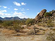
Flora
Many plants not only survive the harsh conditions of the Sonoran Desert, but actually thrive. Many have evolved to have specialized adaptations to the desert climate. The Sonoran Desert's biseasonal rainfall pattern results in more plant species than in the other North America deserts. The Sonoran Desert includes such plants from the agave family, palm family, cactus family, legume family, and many others.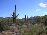
Cylindropuntia
Cylindropuntia is a genus of cacti , containing the chollas. They were formerly treated as a subgenus of Opuntia but have now been separated based on their cylindrical stems and the presence of papery epidermal sheaths on the spines...
, beavertail
Opuntia basilaris
Opuntia basilaris, the Beavertail Cactus, is found in southwest USA, mostly in the Mojave Desert, Anza-Borrego Desert State Park, and Colorado Deserts, and also in the Colorado Plateau and northwest Mexico; it ranges through the Grand Canyon and Colorado River region to southern Utah, and in...
, hedgehog
Echinocereus
Echinocereus is a genus of ribbed, usually small to medium-sized cylindrical cacti, comprising about 70 species from the southern United States and Mexico in very sunny rocky places...
, fishhook
Ferocactus wislizeni
Ferocactus wislizeni, the fishhook barrel cactus, also called Arizona barrel cactus, candy barrel cactus, and Southwestern barrel cactus, is a cylindrical barrel-shaped cactus.-Characteristics:...
, prickly pear
Opuntia
Opuntia, also known as nopales or paddle cactus , is a genus in the cactus family, Cactaceae.Currently, only prickly pears are included in this genus of about 200 species distributed throughout most of the Americas. Chollas are now separated into the genus Cylindropuntia, which some still consider...
, night blooming cereus
Peniocereus
Peniocereus is a genus of vining cacti, comprising about 18 species, found from the southwestern United States and Mexico. They have a large underground tuber, thin and inconspicuous stems.-Synonymy:...
, and organ pipe are other species of cactus found here. Cactus provide food and homes to many desert mammals and birds, with showy flowers in reds, pinks, yellows, and whites blooming most commonly from late March through June, depending on the species and seasonal temperatures.
Creosote bush and bur sage
Ambrosia dumosa
Ambrosia dumosa, the burro-weed or white bursage, is a common constituent of the creosote-bush scrub community throughout the Mojave desert of California, Nevada, and Utah and the Sonoran Desert of Arizona and northwestern Mexico....
dominate valley floors. Indigo bush, Mormon tea, and mesquite
Mesquite
Mesquite is a leguminous plant of the Prosopis genus found in northern Mexico through the Sonoran Desert and Chihuahuan Deserts, and up into the Southwestern United States as far north as southern Kansas, west to the Colorado Desert in California,and east to the eastern fifth of Texas, where...
are other shrubs that may be found. Wildflowers of the Sonoran Desert include desert sand verbena
Abronia villosa
Abronia villosa is a species of sand-verbena known by the common name desert sand-verbena. It is native to the deserts of the southwestern United States and northern Mexico and the southern California and Baja coast.-Description:...
, desert sunflower
Geraea canescens
For other uses, see Desert Sunflower .Geraea canescens is also known as the desert sunflower, hairy desert sunflower, or desert gold. It is a dicot and annual of the Aster family...
, and evening primroses. Ascending from the valley up bajada
Bajada
Bajada may refer to:*Bajada a festival common to the Canary islands* Bajada, a compound Alluvial fan* La Bajada, an escarpment of the Caja del Rio, New Mexico, USA* Clint Bajada , Maltese TV and radio personality...
s, various subtrees such as palo verde, ironwood, desert willow
Chilopsis
Chilopsis is a genus of flowering plant, containing a single species, Chilopsis linearis. It is a small tree native to the southwestern United States and Mexico...
, and crucifixion thorn are common, as well as multi-stemmed ocotillo
Ocotillo
Fouquieria splendens Engelm. is a desert plant of the southwestern United States and northern Mexico. Common names include ocotillo, desert coral, coachwhip, Jacob's staff, and vine cactus, although it is not a true cactus...
. Shrubs found at higher elevations include whitethorn acacia, fairy duster, and jojoba
Jojoba
Jojoba, pronounced , is a shrub native to the Sonoran and Mojave deserts of Arizona, California, and Mexico. It is the sole species of the family Simmondsiaceae, placed in the order Caryophyllales. It is also known as goat nut, deer nut, pignut, wild hazel, quinine nut, coffeeberry, and gray box...
. In the desert subdivisions found on Baja California, cardon cactus, elephant tree, and boojum tree occur. The California Fan Palm is also found in parts of the Sonoran Desert, including areas of the Anza Borrego Desert State Park.
Fauna
Human population
The Sonoran Desert is home to the cultures of seventeen contemporary Native AmericanNative Americans in the United States
Native Americans in the United States are the indigenous peoples in North America within the boundaries of the present-day continental United States, parts of Alaska, and the island state of Hawaii. They are composed of numerous, distinct tribes, states, and ethnic groups, many of which survive as...
Indigenous peoples in Arizona, with settlements at the American Indian reservations in Arizona.
The largest city in the Sonoran Desert is Phoenix, Arizona
Phoenix, Arizona
Phoenix is the capital, and largest city, of the U.S. state of Arizona, as well as the sixth most populated city in the United States. Phoenix is home to 1,445,632 people according to the official 2010 U.S. Census Bureau data...
, with a 2008 metropolitan population of about 4.3 million. Located on the Salt River
Salt River (Arizona)
The Salt River is a stream in the U.S. state of Arizona. It is the largest tributary of the Gila River. The river is about long. Its drainage basin is about large. The longest of the Salt River's many tributaries is the Verde River...
in central Arizona
Arizona
Arizona ; is a state located in the southwestern region of the United States. It is also part of the western United States and the mountain west. The capital and largest city is Phoenix...
, it is one of the fastest-growing metropolitan areas
United States metropolitan area
In the United States a metropolitan statistical area is a geographical region with a relatively high population density at its core and close economic ties throughout the area. Such regions are not legally incorporated as a city or town would be, nor are they legal administrative divisions like...
in the United States. In 2007 in the Phoenix area, desert was losing ground to urban sprawl
Urban sprawl
Urban sprawl, also known as suburban sprawl, is a multifaceted concept, which includes the spreading outwards of a city and its suburbs to its outskirts to low-density and auto-dependent development on rural land, high segregation of uses Urban sprawl, also known as suburban sprawl, is a...
at a rate of approximately 4000 square metre (0.988420652061104 acre) per hour.
The next largest cities are Tucson
Tucson, Arizona
Tucson is a city in and the county seat of Pima County, Arizona, United States. The city is located 118 miles southeast of Phoenix and 60 miles north of the U.S.-Mexico border. The 2010 United States Census puts the city's population at 520,116 with a metropolitan area population at 1,020,200...
, in southern Arizona, with a metro area population of around 1 million, and Mexicali
Mexicali
Mexicali is the capital of the State of Baja California, seat of the Municipality of Mexicali, and 2nd largest city in Baja California. The City of Mexicali has a population of 689,775, according to the 2010 census, while the population of the entire metropolitan area reaches 936,826.The city...
, Baja California
Baja California
Baja California officially Estado Libre y Soberano de Baja California is one of the 31 states which, with the Federal District, comprise the 32 Federal Entities of Mexico. It is both the northernmost and westernmost state of Mexico. Before becoming a state in 1953, the area was known as the North...
, whose municipality
Municipalities of Mexico
Municipalities are the second-level administrative division in Mexico . There are 2,438 municipalities in Mexico, making the average municipality population 45,616...
also has a population of around 900,000. The municipality of Hermosillo
Hermosillo
Hermosillo is a city and municipality located centrally in the northwestern Mexican state of Sonora. It is the capital and main economic center for the state and region. It contains almost all of the state's manufacturing and has thirty percent of its population...
, Sonora
Sonora
Sonora officially Estado Libre y Soberano de Sonora is one of the 31 states which, with the Federal District, comprise the 32 Federal Entities of Mexico. It is divided into 72 municipalities; the capital city is Hermosillo....
, has a population of around 700,000. Ciudad Obregon
Ciudad Obregón
Ciudad Obregon is the second largest city in the northern Mexican state of Sonora and is situated south of the state's northern border with the U.S. state of Arizona. It is also the municipal seat of Cajeme municipality, located in the Yaqui Valley.- History :...
, Sonora
Sonora
Sonora officially Estado Libre y Soberano de Sonora is one of the 31 states which, with the Federal District, comprise the 32 Federal Entities of Mexico. It is divided into 72 municipalities; the capital city is Hermosillo....
, in the southern part of the desert has a population of 375,800.
The Coachella Valley
Coachella Valley
Coachella Valley is a large valley landform in Southern California. The valley extends for approximately 45 miles in Riverside County southeast from the San Bernardino Mountains to the saltwater Salton Sea, the largest lake in California...
is located in the Sonoran Desert and has a population of 365,000. Many famous resort cities such as Palm Springs, CA and Palm Desert, CA are in the Coachella Valley. During the winter months, from November to April, the daytime temperatures in the Coachella Valley range from 70°F (21°C) to 90°F (32°C) and corresponding night-time lows range from 46°F (8°C) to 68°F (20°C) making it a popular winter resort destination. Due to its warm year-round climate tropical fruits such as mangoes, figs and dates are grown there.
Parks, conservation centers and research facilities
The Sonoran Desert National MonumentSonoran Desert National Monument
Sonoran Desert National Monument is located south of Goodyear and Buckeye and east of Gila Bend, Arizona. Created by Presidential proclamation on January 17, 2001, the 496,337 acre monument is managed by the U.S. Bureau of Land Management , an agency within the U.S. Department of the...
, 2008 square kilometres (496,187.2 acre) in Arizona, was created in 2001 to enhance protection of the unique resources of the Sonoran Desert.
- See also
- Cabeza Prieta National Wildlife RefugeCabeza Prieta National Wildlife RefugeThe Cabeza Prieta National Wildlife Refuge is located in the Sonoran Desert in southwestern Arizona in the United States. The refuge, established in 1939 to protect Desert Bighorn Sheep, is located along of the U.S.-Mexico border, and covers 860,010 acres — larger than the land area of the state...
- Kofa National Wildlife RefugeKofa National Wildlife RefugeThe Kofa National Wildlife Refuge is located northeast of Yuma, Arizona, southeast of Quartzsite, Arizona, in the southwestern United States. The refuge, established in 1939 to protect Desert Bighorn Sheep, encompasses over of the Yuma Desert region of the Sonoran Desert...
- Organ Pipe Cactus National MonumentOrgan Pipe Cactus National MonumentOrgan Pipe Cactus National Monument is a U.S. National Monument and UNESCO biosphere reserve located in extreme southern Arizona which shares a border with the Mexican state of Sonora. The park is the only place in the United States where the Organ Pipe Cactus grows wild...
- Reserva de la Biosfera el Pinacate y Gran Desierto de AltarPinacate PeaksThe Pinacate Peaks are a volcanic group of volcanic peaks and cinder cones located mostly in the Mexican state of Sonora along the international border adjacent to the U.S...
, ('Pinacate National Park,' in Mexico) - Saguaro National ParkSaguaro National ParkSaguaro National Park, located in southern Arizona, is part of the United States National Park System.-Overview:The park is divided into two sections, called districts, lying approximately east and west of the center of the city of Tucson, Arizona. The total area in 2010 was of which is...
- Sonoran Arthropod Studies InstituteSonoran Arthropod Studies InstituteThe Sonoran Arthropod Studies Institute is a non-profit organization, located in the Sonoran Desert in Tucson, Arizona, whose mission is to educate the public about arthropods. The Institute routinely conducts field trips and educational visits, as well as maintains a collection of living and...
- Cabeza Prieta National Wildlife Refuge
See also
Mountain Ranges of the Sonoran Desert- Spanish missions in the Sonoran DesertSpanish missions in the Sonoran DesertThe Spanish missions in the Sonoran Desert are a series of Jesuit Catholic religious outposts established by the Spanish Catholic Jesuits and other orders for religious conversions of the Pima and Tohono O'odham indigenous peoples residing in the Sonoran Desert...
- Yuma DesertYuma DesertThe Yuma Desert is a lower-elevation section of the Sonoran Desert in the southwestern United States and the northwest of Mexico. It is in the Salton basin. The desert contains areas of sparse vegetation and has notable areas of sand dunes. With an average rainfall less than 8 inches each...
- Colorado DesertColorado DesertCalifornia's Colorado Desert is a part of the larger Sonoran Desert, which extends across southwest North America. The Colorado Desert region encompasses approximately , reaching from the Mexican border in the south to the higher-elevation Mojave Desert in the north and from the Colorado River in...
- Gran Desierto de AltarGran Desierto de AltarThe Gran Desierto de Altar is one of the major portions of the Sonoran Desert of Mexico, including the only active erg dune region in North America. It extends across much of the northern border of the Gulf of California, reaching more than 100 kilometers east to west, and over 50 km north to...
Deserts of the Lower Colorado River Valley
- Chihuahuan DesertChihuahuan DesertThe Chihuahuan Desert is a desert, and an ecoregion designation, that straddles the U.S.-Mexico border in the central and northern portions of the Mexican Plateau, bordered on the west by the extensive Sierra Madre Occidental range, and overlaying northern portions of the east range, the Sierra...
- Mojave DesertMojave DesertThe Mojave Desert occupies a significant portion of southeastern California and smaller parts of central California, southern Nevada, southwestern Utah and northwestern Arizona, in the United States...
- List of deserts by area
- List of ecoregions in the United States (WWF)
External links
- Arizona-Sonora Desert Museum
- Sonoran Desert and its subdivisions, with map and photos
- Timeline of the Sonoran desert
- An Overview of the Sonoran Desert, by William G. McGinnies
- The Sonoran Desert Naturalist
- Very short overview of Sonoran Desert Geology
- Sonoran desert (World Wildlife Fund)
- Sonoran Desert images at bioimages.vanderbilt.edu (slow modem version)
- International Sonoran Desert Alliance
- Sounds of the Sonoran Desert)