

Trade route
Encyclopedia
A trade route is a logistical network
identified as a series of pathways and stoppages used for the commercial transport of cargo. Allowing good
s to reach distant market
s, a single trade route contains long distance arteries
which may further be connected to several smaller networks of commercial and non commercial transportation.
Historically, the period from 1250 BCE–153 CE saw the Western Asian, Mediterranean, Chinese and Indian societies develop major transportation networks for trade. Europe's early trading routes included the Amber Road
, which served as a dependable network for long distance trade. Maritime trade along the Spice route became prominent during the Middle Ages
; nations resorted to military means for control of this influential route. During the Middle Ages organizations such as the Hanseatic League
, aimed at protecting interests of the merchants and trade, also became increasingly prominent.
With the advent of modern times
, commercial activity shifted from the major trade routes of the Old World
to newer routes between modern nation states. This activity was sometimes carried out without traditional protection of trade and under international free trade
agreements, which allowed commercial goods to cross borders with relaxed restrictions. Innovative transportation of the modern times includes pipeline transport
, and the relatively well known trade using rail routes, automobiles and cargo airlines.
saw societies in Western Asia, the Mediterranean, China and the Indian sub-continent develop major transportation networks for trade.
One of the vital instruments which facilitated long distance trade was portage
and the domestication of beasts of burden
. Organized caravans, visible by the 2nd millennium BCE, could carry goods across a large distance as fodder was mostly available along the way. The domestication of camel
s allowed Arabian nomads to control the long distance trade in spice
s and silk
from the Far East
to the Arabian Peninsula
. However, caravans were useful in long-distance trade largely for carrying luxury goods, the transportation of cheaper goods across large distances was not profitable for caravan operators. With productive developments in iron and bronze technologies, newer trade routes - dispensing innovations of civilizations - began to rise slowly.
 Evidence of maritime trade between civilizations dates back at least two millennia. Navigation was known in Sumer
between the 4th and the 3rd millennium BCE, and was probably known by the India
ns and the Chinese people
before the Sumerians. The Egyptians
had trade routes through the Red sea
, importing spices from the "Land of Punt
" (East Africa
) and from Arabia.
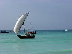
 Maritime trade began with safer coastal trade and evolved with the manipulation of the monsoon winds, soon resulting in trade crossing boundaries such as the Arabian Sea
and the Bay of Bengal
. South Asia
had multiple maritime trade routes which connected it to Southeast Asia
, thereby making the control of one route resulting in maritime monopoly difficult. Indian connections to various Southeast Asian states buffered it from blockages on other routes. By making use of the maritime trade routes, bulk commodity trade became possible for the Romans in the 2nd century BCE. A Roman trading vessel could span the Mediterranean in a month at one-sixtieth the cost of over-land routes.
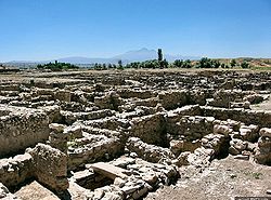
lay on the commercial land routes to Europe from Asia as well as the sea route from the Mediterranean to the Black Sea
. Records from the 19th century BCE attest to the existence of an Assyria
n merchant colony at Kanesh in Cappadocia
(now in modern Turkey
). Trading networks of the Old World included the Grand Trunk Road
of India and the Incense Road
of Arabia. A transportation network consisting of hard-surfaced highways, using concrete made from volcanic ash and lime, was built by the Romans as early as 312 BCE, during the times of the Censor Appius Claudius Caecus
. Parts of the Mediterranean world, Roman Britain
, Tigris-Euphrates river system and North Africa fell under the reach of this network at some point of their history.
According to Robert Allen Denemark (2000):
These routes - spreading religion
, trade and technology - have historically been vital to the growth of urban civilization. The extent of development of cities, and the level of their integration into a larger world system, has often been attributed to their position in various active transport networks.
and the frankincense
and myrrh
trees were seen as a source of wealth by the its rulers.
Ptolemy II Philadelphus
, emperor of Ptolemaic Egypt
, may have forged an alliance with the Lihyan
ites in order to secure the incense route at Dedan
, thereby rerouting the incense trade from Dedan to the coast along the Red Sea to Egypt. I. E. S. Edwards connects the Syro-Ephraimite War
to the desire of the Israelites and the Aramaeans
to control the northern end of the Incense route, which ran up from Southern Arabia and could be tapped by commanding Transjordan
.
Gerrha
- inhabited by Chaldea
n exiles from Babylon
- controlled the Incense trade routes across Arabia to the Mediterranean and exercised control over the trading of aromatics to Babylon in the 1st century BC. The Nabateans exercised control over the routes along the Incense Route, and their hold was challenged - without success - by Antigonus Cyclops, emperor of Syria. The Nabatean control over trade further increased and spread in many directions.
The replacement of Greece by the Roman empire
as the administrator of the Mediterranean basin led to the resumption of direct trade with the East and the elimination of the taxes extracted previously by the middlemen of the south. According to Milo Kearney (2003) "The South Arabs in protest took to pirate attacks over the Roman ships in the Gulf of Aden
. In response, the Romans destroyed Aden and favored the Western Abyssinian coast of the Red Sea." Indian ships sailed to Egypt as the maritime routes of Southern Asia were not under the control of a single power.
n and the Andean cultures suggest that the two regions became a part of a wider world system, as a result of trade, by the 1st millennium BCE. The current academic view is that the flow of goods across the Andean slopes was controlled by institutions distributing locations to local groups, who were then free to access them for trading. This trade across the Andean slopes - described sometimes as "vertical trade" - may have overshadowed the long distance trade between the people of the Andes and the neighboring forests. The Callawaya herbalists traded in tropical plants between 6th and the 10th centuries, while copper was dealt by specialized merchants in the Peru
vian valley of Chincha
. Long distance trade may have seen local elites resorting to struggle in order for manipulation and control.
Prior to the Inca dominance, specialized long distance merchants provided the highlanders with goods such as gold nuggets, copper hatches, cocoa, salt etc. for redistribution among the locals, and were key players in the politics of the region. Hatchet shaped copper currency was produced by the Peruvian people
, in order to obtain valuables from pre Columbian Ecuador
. A maritime exchange system stretched from the west coast of Mexico to southernmost Peru, trading mostly in Spondylus
, which represented rain, fertility and was considered the principal food of the gods by the people of the Inca empire
. Spondylus was used in elite rituals and the effective redistribution of it had political effect in the Andes during the pre-Hispanic times.
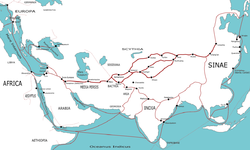 The Silk road was one of the first trade routes to join the Eastern
and the Western world
s. According to Vadime Elisseeff (2000):
Cultural interactions patronized often by powerful emperors, such as Kanishka
, led to development of art due to introduction of a rich variety of influences. Buddhist missions
thrived along the Silk Roads, partly due to the conducive intermixing of trade and cultural values, which created a series of safe stoppages for both the pilgrims and the traders. Among the frequented routes of the Silk Route was the Burmese
route extending from Bhamo
, which served as a path for Marco Polo
's visit to Yunnan
and Indian Buddhist missions to Canton
in order to establish Buddhist monasteries. This route - often under the presence of hostile tribes - also finds mention in the works of Rashid-al-Din Hamadani.
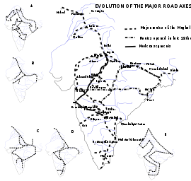
The Grand Trunk Road - connecting Calcutta in India to Peshawar
in Pakistan - has existed for over two and a half millennia. One of the important trade routes of the world, this road has been a strategic artery with fortresses, halting posts, well
s, post office
s, milestone
s and other facilities. Part of this road through Pakistan also coincided with the Silk Road.
This highway has been associated with emperors Chandragupta Maurya
and Sher Shah Suri
, the latter became synonymous with this route due to his role in ensuring the safety of the travelers and the upkeep of the road. Emperor Sher Shah widened and realigned the road to other routes, and provided approximately 1700 roadside inns through his empire. These inns provided free food and lodgings to the travelers regardless of their status.
The British occupation of this road was of special significance for the British Raj
in India. Bridges, pathways and newer inns were constructed by the British for the first thirty seven years of their reign since the occupation of Punjab
in 1849. The British followed roughly the same alignment as the old routes, and at some places the newer routes ran parallel to the older routes.
Vadime Elisseeff (2000) comments on the Grand Trunk Road:
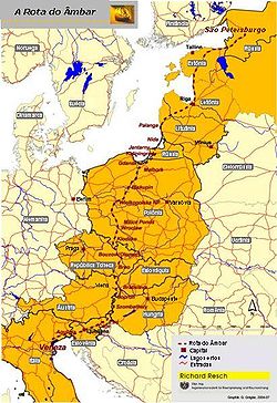
The Amber Road was a European trade route associated with the trade and transport of amber
. Amber satisfied the criteria for long distance trade as it was light in weight and was in high demand for ornamental purposes around the Mediterranean. Before the establishment of Roman control over areas such as Pannonia
, the Amber Road was virtually the only route available for long distance trade.
Towns along the Amber Road began to rise steadily during the 1st century CE, despite the troop movements under Titus Flavius Vespasianus
and his son Titus Flavius Domitianus
.
Under the reign of Tiberius Caesar Augustus
, the Amber Road was straightened and paved according to the prevailing urban standards. Roman towns began to appear along the road, initially founded near the site of Celtic oppida.
The 3rd century saw the Danube
river become the principal artery of trade, eclipsing the Amber Road and other commercial routes. The redirection of investment to the Danubian forts saw the towns along the Amber Road growing slowly, though yet retaining their prosperity. The prolonged struggle between the Romans and the barbarians further left its mark on the towns along the Amber Road.
Via Maris, literally Latin
for "the way of the sea," was an ancient highway used by the Romans and the Crusaders
. The states controlling the Via Maris were in a position to grant access for trade to their own citizens and collect tolls from the outsiders to maintain the trade route. The name Via Maris is a Latin translation of a Hebrew phrase related to Isaiah
. Due to the Biblical significance of this ancient route, many attempts to find its present day location have been made by Christian
pilgrims. 13th century traveler and pilgrim Burchard of Mount Zion
refers to the Via Maris route as a way leading along the shore of the Sea of Galilee
.
operated a sophisticated network of trade, usually under the authority of a monarch who levied taxes and provided bureaucratic and military support to his kingdom. Sophisticated mechanisms for the economic and political development of the involved African areas were in place before Islam
further strengthened trade, towns and government in western Africa. The capital, court and trade of the region find mention in the works of scholar Abū 'Ubayd 'Abd Allāh al-Bakrī; the mainstay of the trans Saharan
trade was gold and salt.
The powerful Saharan tribes, Berber
in origin and later adapting to Muslim and Arab cultures, controlled the channels to western Africa by making efficient use of horse-drawn vehicles and pack animals. The Songhai engaged in a struggle against the Sa'di dynasty of Morocco
over the control of the trans Saharan trade, resulting in damage on both sides and a weak Moroccan victory, further strengthening the uninvolved Saharan tribes. Struggles and disturbances continued till the 14th century, by which the Mandé merchants were trading with the Hausa
, between Lake Chad
and the Niger
. Newer trade routes developed following extension of trade.
 The Ptolemaic dynasty
had initiated Greco-Roman maritime trade contact with India using the Red Sea ports. The Roman historian Strabo
mentions a vast increase in trade following the Roman annexation of Egypt, indicating that monsoon was known and manipulated for trade in his time. By the time of Augustus
up to 120 ships were setting sail every year from Myos Hormos
to India, trading in a diverse variety of goods. Arsinoe
, Berenice Troglodytica and Myos Hormos were the principal Roman ports involved in this maritime trading network, while the Indian ports included Barbaricum, Barygaza
, Muziris
and Arikamedu
.
The Indians were present in Alexandria
and the Christian and Jewish settlers from Rome continued to live in India long after the fall of the Roman empire, which resulted in Rome's loss of the Red Sea
ports, previously used to secure trade with India by the Greco-Roman world since the time of the Ptolemaic dynasty.
 Shortly before the 12th century the Germans
played a relatively modest role in the north European trade. However, this was to change with the development of Hanseatic trade, as a result of which German traders became prominent in the Baltic
and the North Sea
regions. Following the death of Eric VI of Denmark
, German forces attacked and sacked Denmark, bringing with them artisans and merchants under the new administration which controlled the Hansa regions. During the third quarter of the 14th century the Hanseatic trade faced two major difficulties: economic conflict with the Flanders
and hostilities with Denmark. These events led to the formation of an organized association of Hanseatic towns, which replaced the earlier union of German merchants. This new Hansa of the towns - aimed at protecting interests of the merchants and trade - became prominent for the next hundred and fifty years.
Philippe Dollinger associates the downfall of the Hansa to a new alliance between Lübeck
, Hamburg
and Bremen
, which outshadowed the older institution. He further sets the date of dissolution of the Hansa at 1630 and concludes that the Hansa was almost entirely forgotten by the end of the 18th century. Scholar Georg Friedrich Sartorius
published the first monograph
regarding the community in the early years of the 19th century.
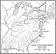
The route began in Scandinavian trading centres such as Birka, Hedeby, and Gotland, crossed the Baltic Sea entered the Gulf of Finland, followed the Neva River into the Lake Ladoga. Then it followed the Volkhov River, upstream past the towns of Staraya Ladoga and Velikiy Novgorod, crossed Lake Ilmen, and up the Lovat River. From there, ships had to be portaged to the Dnieper River near Gnezdovo. A second route from the Baltic to the Dnieper was along the Western Dvina (Daugava) between the Lovat and the Dnieper in the Smolensk region, and along the Kasplya River to Gnezdovo. Along the Dnieper, the route crossed several major rapids and passed through Kiev, and after entering the Black Sea followed its west coast to Constantinople.
around the year 1000, together with the lack of safety on the mainland trading routes, eased the development of major commercial routes along the coast of the Mediterranean
. The growing independence of some coastal cities gave them a leading role in this comerce: Maritime Republics (Italian "Repubbliche Marinare") of Venice
, Genoa
, Amalfi
, Pisa
and Republic of Ragusa
developed their own "empires" in the Mediterranean shores.
From the 8th until the 15th century, they held the monopoly of European trade with the Middle East. The silk
and spice trade
, involving spice
s, incense
, herb
s, drug
s and opium
, made these Mediterranean city-states phenomenally rich. Spices were among the most expensive and demanded products of the Middle Ages. They were all imported from Asia and Africa. Muslim traders—mainly descendants of Arab sailors from Yemen
and Oman
—dominated maritime routes throughout the Indian Ocean, tapping source regions in the Far East
and shipping for trading emporiums in India, westward to Ormus
in Persian Gulf
and Jeddah
in the Red Sea
. From there, overland routes led to the Mediterranean coasts. Venetian merchants distributed then the goods through Europe until the rise of the Ottoman Empire
, that eventually led to the fall of Constantinople
in 1453, barring Europeans from important combined-land-sea routes.
increased spices became the main import from India to the Western world, bypassing silk and other commodities. The Indian commercial connection with South East Asia proved vital to the merchants of Arabia and Persia during the 7th century and the 8th century.
The Abbasids used Alexandria, Damietta
, Aden
and Siraf
as entry ports to India and China. Merchants arriving from India in the port city of Aden paid tribute in form of musk
, camphor
, ambergris
and sandalwood to Ibn Ziyad, the sultan
of Yemen. Moluccan products shipped across the ports of Arabia to the Near East passed through the ports of India and Sri Lanka
. Indian exports of spices find mention in the works of Ibn Khurdadhbeh (850), al-Ghafiqi (1150 AD), Ishak bin Imaran (907) and Al Kalkashandi (14th century). After reaching either the Indian or the Sri Lankan ports, spices were sometimes shipped to East Africa, where they were used for many purposes, including burial rites.
On the orders of Manuel I of Portugal
, four vessels under the command of navigator Vasco da Gama rounded the Cape of Good Hope
, continuing to the eastern coast of Africa to Malindi
to sail across the Indian Ocean to Calicut
. The wealth of the Indies
was now open for the Europeans to explore; the Portuguese Empire
I was one of the early European empires to grow from spice trade.
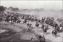
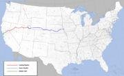
and the Oregon Trail
, became prominent in the United States with wagon train
s gaining popularity as a mode of long distance overland transportation for both people and goods. The Oregon
-California
routes were highly organized with planned rendezvous locations and essential supplies. The settlers in the United States used these wagon trains - sometimes made up of 100 of more Conestoga wagon
s - for westward emigration during the 18th and the 19th centuries. Among the challenges faced by the wagon route operators were crossing rivers, mountains and hostile Native American
s. Preparations were also made according to the weather and protection of trade and travelers was ensured by a few guards on horseback.
Wagon freighting was also essential to American growth until it was replaced by the railroad and the truck
.
 The 1844 Railway act of England compelled at least one train
to a station every day with the third class fares priced at a penny
a mile. Trade benefited as the workers and the lower classes had the ability to travel to other towns frequently. Suburban communities began to develop and towns began to spread outwards. The British constructed a vast railway network in India, but it was considered to serve a strategic purpose in addition to the commercial purpose. The efficient use of rail routes helped in the unification of the United States of America.
The modern times saw nations struggle for the control of rail routes: The Trans-Siberian Railway
was intended to be used by the Russian government for control of Manchuria
and later China; the German forces wanted to establish Berlin-Baghdad Railway in order to influence the Near East; and the Austrian government planned a route from Vienna
to Salonika for control of the Balkans
.
According to the Encyclopædia Britannica
(2002):
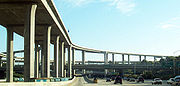 The advent motor vehicles created a demand for better use of highways. Roads evolved into two way roads, expressways
, freeways and tollways during the modern times. Existing roads were developed and highways were designed according to intended use.
Truck
s came into widespread use in the Western World during World War I, and quickly gained reputation as a means of long distance transportation of goods. Modern highways, such as the Trans-Canada Highway
, Highway 1 (Australia)
and Pan-American Highway
allowed transport of goods and services across great distances. Automobiles continue to play a crucial role in the economies of the Industrialized countries, resulting in rise of businesses such as motor freight operation and truck transportation.
The emission rate for cars using highways has been on a decline between 1975 and 1995 due to regulations and the introduction of unleaded petrol. This trend is especially notable since there has been a growth in vehicles and vehicle miles traveled by automobiles using these highways.
 A consistent shift from land based trade to sea based trade has been recorded since the last three millennia. The strategic advantages of port cities as trading centers are many: they are both less dependent on vital connections and less vulnerable to blockages. Oceanic ports can help forge trading relationships with other parts of the world easily.
Modern maritime trade routes - sometimes in the form of artificial canals like the Suez Canal
- had visible impact on the economic and political standing of nations. The opening of the Suez Canal altered British interactions with the colonies of the British Empire
as the dynamics of transportation, trade and communication had now changed drastically. Other waterways, like the Panama Canal
played an important role in the histories of many nations. Inland water transportation remained significantly important even as the advent of railroads and automobiles resulted in a steady decline of canals. Inland water transport is still used for the transportation of bulk commodities e.g. grains, coal, and ore.
Waterway commerce was historically important to Europe, particularly to Russia. According to the Encyclopædia Britannica (2002): "Russia has been a significant beneficiary. Not only have inland waterways opened vast areas of its interior to development, but Moscow-linked to the White
, Baltic
, Black
, Caspian
, and Azov seas by canals and rivers-has become a major inland port."
Oil spills are recorded both in case of maritime routes and pipeline routes to the main refineries. Oil spills, amounting to as much as 7.56 billion liters of oil entering the oceans every year, occur due to damaged equipment or human error.
 Historically, many governments followed a policy of protection of trade. International free trade
became visible in 1860 with the Anglo-French commercial treaty, and the trend gained further momentum during the period after World War II.
According to The Columbia Encyclopedia, Sixth Edition:
In May 2004 the United States of America signed the American Free trade Agreement with five Central American nations.
 Air transport has become an indispensable part of the modern society. People having been using air transport both for long and middle distances, with the average route length of long distances being 720 kilometers in Europe and 1220 kilometers in the US. This enormous industry annually carries 1600 million passengers worldwide, and covers a 15 million kilometer network with an annual turnover of 260 billion dollars.
The national, international and global economies are linked to this mode of transportation, making it vital to many other industries. Newer trends of liberalization of trade have further led to establishment of routes among nations bound by agreements. One such example is the American Open Skies policy
, which led to greater openness in many international markets, but some international restrictions have survived even during the present times.
Express delivery through international cargo airline
s touched US $ 20 billion in 1998 and, according to the World Trade Organization, is expected to triple in 2015. In 1998, 50 pure cargo service companies operated internationally.
 The economic importance of pipeline transport - responsible for a high percentage of oil and natural gas transportation - is often undermined by the general public due to the lack of visibility of this mode. Generally held to be safer and more economical and reliable than the other modes of transport, this mode has many advantages over rival modes, such as trucks and railways. Examples of modern pipeline transport include Alashankou-Dushanzi Crude Oil Pipeline and Iran-Armenia Natural Gas Pipeline
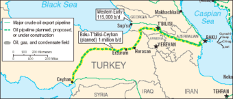
. International pipeline transport projects, like the Baku-Tbilisi-Ceyhan pipeline
, presently connect modern nation states - in this case Azerbaijan
, Georgia
and Turkey - through pipeline networks.
In some select cases, pipelines can even transport solids, such as coal and other minerals, over long distances; short distance transportation of goods such as grain, cement, concrete, solid wastes, pulp etc. is also feasible.
Logistics
Logistics is the management of the flow of goods between the point of origin and the point of destination in order to meet the requirements of customers or corporations. Logistics involves the integration of information, transportation, inventory, warehousing, material handling, and packaging, and...
identified as a series of pathways and stoppages used for the commercial transport of cargo. Allowing good
Good (economics and accounting)
In economics, a good is something that is intended to satisfy some wants or needs of a consumer and thus has economic utility. It is normally used in the plural form—goods—to denote tangible commodities such as products and materials....
s to reach distant market
Market
A market is one of many varieties of systems, institutions, procedures, social relations and infrastructures whereby parties engage in exchange. While parties may exchange goods and services by barter, most markets rely on sellers offering their goods or services in exchange for money from buyers...
s, a single trade route contains long distance arteries
Arterial road
An arterial road, or arterial thoroughfare, is a high-capacity urban road. The primary function of an arterial road is to deliver traffic from collector roads to freeways, and between urban centres at the highest level of service possible. As such, many arteries are limited-access roads, or feature...
which may further be connected to several smaller networks of commercial and non commercial transportation.
Historically, the period from 1250 BCE–153 CE saw the Western Asian, Mediterranean, Chinese and Indian societies develop major transportation networks for trade. Europe's early trading routes included the Amber Road
Amber Road
The Amber Road was an ancient trade route for the transfer of amber. As one of the waterways and ancient highways, for centuries the road led from Europe to Asia and back, and from northern Africa to the Baltic Sea....
, which served as a dependable network for long distance trade. Maritime trade along the Spice route became prominent during the Middle Ages
Middle Ages
The Middle Ages is a periodization of European history from the 5th century to the 15th century. The Middle Ages follows the fall of the Western Roman Empire in 476 and precedes the Early Modern Era. It is the middle period of a three-period division of Western history: Classic, Medieval and Modern...
; nations resorted to military means for control of this influential route. During the Middle Ages organizations such as the Hanseatic League
Hanseatic League
The Hanseatic League was an economic alliance of trading cities and their merchant guilds that dominated trade along the coast of Northern Europe...
, aimed at protecting interests of the merchants and trade, also became increasingly prominent.
With the advent of modern times
Modern Times
Modern Times can refer to modern history.It may also refer to:* Modern Times , a 1936 Charlie Chaplin film* Modern Times , a 1975 album by Al Stewart...
, commercial activity shifted from the major trade routes of the Old World
Old World
The Old World consists of those parts of the world known to classical antiquity and the European Middle Ages. It is used in the context of, and contrast with, the "New World" ....
to newer routes between modern nation states. This activity was sometimes carried out without traditional protection of trade and under international free trade
Free trade
Under a free trade policy, prices emerge from supply and demand, and are the sole determinant of resource allocation. 'Free' trade differs from other forms of trade policy where the allocation of goods and services among trading countries are determined by price strategies that may differ from...
agreements, which allowed commercial goods to cross borders with relaxed restrictions. Innovative transportation of the modern times includes pipeline transport
Pipeline transport
Pipeline transport is the transportation of goods through a pipe. Most commonly, liquids and gases are sent, but pneumatic tubes that transport solid capsules using compressed air are also used....
, and the relatively well known trade using rail routes, automobiles and cargo airlines.
Development of early routes
Early development
The period from the middle of the 2nd millennium BCE to the beginning of the Common EraCommon Era
Common Era ,abbreviated as CE, is an alternative designation for the calendar era originally introduced by Dionysius Exiguus in the 6th century, traditionally identified with Anno Domini .Dates before the year 1 CE are indicated by the usage of BCE, short for Before the Common Era Common Era...
saw societies in Western Asia, the Mediterranean, China and the Indian sub-continent develop major transportation networks for trade.
One of the vital instruments which facilitated long distance trade was portage
Portage
Portage or portaging refers to the practice of carrying watercraft or cargo over land to avoid river obstacles, or between two bodies of water. A place where this carrying occurs is also called a portage; a person doing the carrying is called a porter.The English word portage is derived from the...
and the domestication of beasts of burden
Working animal
A working animal is an animal, usually domesticated, that is kept by humans and trained to perform tasks. They may be close members of the family, such as guide or service dogs, or they may be animals trained strictly to perform a job, such as logging elephants. They may also be used for milk, a...
. Organized caravans, visible by the 2nd millennium BCE, could carry goods across a large distance as fodder was mostly available along the way. The domestication of camel
Camel
A camel is an even-toed ungulate within the genus Camelus, bearing distinctive fatty deposits known as humps on its back. There are two species of camels: the dromedary or Arabian camel has a single hump, and the bactrian has two humps. Dromedaries are native to the dry desert areas of West Asia,...
s allowed Arabian nomads to control the long distance trade in spice
Spice
A spice is a dried seed, fruit, root, bark, or vegetative substance used in nutritionally insignificant quantities as a food additive for flavor, color, or as a preservative that kills harmful bacteria or prevents their growth. It may be used to flavour a dish or to hide other flavours...
s and silk
Silk
Silk is a natural protein fiber, some forms of which can be woven into textiles. The best-known type of silk is obtained from the cocoons of the larvae of the mulberry silkworm Bombyx mori reared in captivity...
from the Far East
Far East
The Far East is an English term mostly describing East Asia and Southeast Asia, with South Asia sometimes also included for economic and cultural reasons.The term came into use in European geopolitical discourse in the 19th century,...
to the Arabian Peninsula
Arabian Peninsula
The Arabian Peninsula is a land mass situated north-east of Africa. Also known as Arabia or the Arabian subcontinent, it is the world's largest peninsula and covers 3,237,500 km2...
. However, caravans were useful in long-distance trade largely for carrying luxury goods, the transportation of cheaper goods across large distances was not profitable for caravan operators. With productive developments in iron and bronze technologies, newer trade routes - dispensing innovations of civilizations - began to rise slowly.
Maritime trade
Sumer
Sumer was a civilization and historical region in southern Mesopotamia, modern Iraq during the Chalcolithic and Early Bronze Age....
between the 4th and the 3rd millennium BCE, and was probably known by the India
India
India , officially the Republic of India , is a country in South Asia. It is the seventh-largest country by geographical area, the second-most populous country with over 1.2 billion people, and the most populous democracy in the world...
ns and the Chinese people
Chinese people
The term Chinese people may refer to any of the following:*People with Han Chinese ethnicity ....
before the Sumerians. The Egyptians
Ancient Egypt
Ancient Egypt was an ancient civilization of Northeastern Africa, concentrated along the lower reaches of the Nile River in what is now the modern country of Egypt. Egyptian civilization coalesced around 3150 BC with the political unification of Upper and Lower Egypt under the first pharaoh...
had trade routes through the Red sea
Red Sea
The Red Sea is a seawater inlet of the Indian Ocean, lying between Africa and Asia. The connection to the ocean is in the south through the Bab el Mandeb strait and the Gulf of Aden. In the north, there is the Sinai Peninsula, the Gulf of Aqaba, and the Gulf of Suez...
, importing spices from the "Land of Punt
Land of Punt
The Land of Punt, also called Pwenet, or Pwene by the ancient Egyptians, was a trading partner known for producing and exporting gold, aromatic resins, African blackwood, ebony, ivory, slaves and wild animals...
" (East Africa
East Africa
East Africa or Eastern Africa is the easterly region of the African continent, variably defined by geography or geopolitics. In the UN scheme of geographic regions, 19 territories constitute Eastern Africa:...
) and from Arabia.
Arabian Sea
The Arabian Sea is a region of the Indian Ocean bounded on the east by India, on the north by Pakistan and Iran, on the west by the Arabian Peninsula, on the south, approximately, by a line between Cape Guardafui in northeastern Somalia and Kanyakumari in India...
and the Bay of Bengal
Bay of Bengal
The Bay of Bengal , the largest bay in the world, forms the northeastern part of the Indian Ocean. It resembles a triangle in shape, and is bordered mostly by the Eastern Coast of India, southern coast of Bangladesh and Sri Lanka to the west and Burma and the Andaman and Nicobar Islands to the...
. South Asia
South Asia
South Asia, also known as Southern Asia, is the southern region of the Asian continent, which comprises the sub-Himalayan countries and, for some authorities , also includes the adjoining countries to the west and the east...
had multiple maritime trade routes which connected it to Southeast Asia
Southeast Asia
Southeast Asia, South-East Asia, South East Asia or Southeastern Asia is a subregion of Asia, consisting of the countries that are geographically south of China, east of India, west of New Guinea and north of Australia. The region lies on the intersection of geological plates, with heavy seismic...
, thereby making the control of one route resulting in maritime monopoly difficult. Indian connections to various Southeast Asian states buffered it from blockages on other routes. By making use of the maritime trade routes, bulk commodity trade became possible for the Romans in the 2nd century BCE. A Roman trading vessel could span the Mediterranean in a month at one-sixtieth the cost of over-land routes.
Visible trade routes
The peninsula of AnatoliaAnatolia
Anatolia is a geographic and historical term denoting the westernmost protrusion of Asia, comprising the majority of the Republic of Turkey...
lay on the commercial land routes to Europe from Asia as well as the sea route from the Mediterranean to the Black Sea
Black Sea
The Black Sea is bounded by Europe, Anatolia and the Caucasus and is ultimately connected to the Atlantic Ocean via the Mediterranean and the Aegean seas and various straits. The Bosphorus strait connects it to the Sea of Marmara, and the strait of the Dardanelles connects that sea to the Aegean...
. Records from the 19th century BCE attest to the existence of an Assyria
Assyria
Assyria was a Semitic Akkadian kingdom, extant as a nation state from the mid–23rd century BC to 608 BC centred on the Upper Tigris river, in northern Mesopotamia , that came to rule regional empires a number of times through history. It was named for its original capital, the ancient city of Assur...
n merchant colony at Kanesh in Cappadocia
Cappadocia
Cappadocia is a historical region in Central Anatolia, largely in Nevşehir Province.In the time of Herodotus, the Cappadocians were reported as occupying the whole region from Mount Taurus to the vicinity of the Euxine...
(now in modern Turkey
Turkey
Turkey , known officially as the Republic of Turkey , is a Eurasian country located in Western Asia and in East Thrace in Southeastern Europe...
). Trading networks of the Old World included the Grand Trunk Road
Grand Trunk Road
The Grand Trunk Road also formerly known as Uttarapatha, Shah Rah-e-Azam or Sadak-e-Azam or Badshahi Sadak is one of South Asia's oldest and longest major roads...
of India and the Incense Road
Incense Road
The Incense trade route or the Incense Road of Antiquity comprised a network of major ancient trading routes linking the Mediterranean world with Eastern sources of incense , stretching from Mediterranean ports across the Levant and Egypt through Arabia to India...
of Arabia. A transportation network consisting of hard-surfaced highways, using concrete made from volcanic ash and lime, was built by the Romans as early as 312 BCE, during the times of the Censor Appius Claudius Caecus
Appius Claudius Caecus
Appius Claudius Caecus was a Roman politician from a wealthy patrician family. He was dictator himself and the son of Gaius Claudius Crassus, dictator in 337 BC.-Life:...
. Parts of the Mediterranean world, Roman Britain
Roman Britain
Roman Britain was the part of the island of Great Britain controlled by the Roman Empire from AD 43 until ca. AD 410.The Romans referred to the imperial province as Britannia, which eventually comprised all of the island of Great Britain south of the fluid frontier with Caledonia...
, Tigris-Euphrates river system and North Africa fell under the reach of this network at some point of their history.
According to Robert Allen Denemark (2000):
"The spread of urban trading networks, and their extension along the Persian GulfPersian GulfThe Persian Gulf, in Southwest Asia, is an extension of the Indian Ocean located between Iran and the Arabian Peninsula.The Persian Gulf was the focus of the 1980–1988 Iran-Iraq War, in which each side attacked the other's oil tankers...
and eastern Mediterranean, created a complex molecular structure of regional foci so that as well as the zonation of core and periphery (originally created around MesopotamiaMesopotamiaMesopotamia is a toponym for the area of the Tigris–Euphrates river system, largely corresponding to modern-day Iraq, northeastern Syria, southeastern Turkey and southwestern Iran.Widely considered to be the cradle of civilization, Bronze Age Mesopotamia included Sumer and the...
) there was a series of interacting civilizations: Mesopotamia, Egypt, the Indus ValleyIndus Valley CivilizationThe Indus Valley Civilization was a Bronze Age civilization that was located in the northwestern region of the Indian subcontinent, consisting of what is now mainly modern-day Pakistan and northwest India...
; then also SyriaSyriaSyria , officially the Syrian Arab Republic , is a country in Western Asia, bordering Lebanon and the Mediterranean Sea to the West, Turkey to the north, Iraq to the east, Jordan to the south, and Israel to the southwest....
, central Anatolia (HittitesHittitesThe Hittites were a Bronze Age people of Anatolia.They established a kingdom centered at Hattusa in north-central Anatolia c. the 18th century BC. The Hittite empire reached its height c...
) and the AegeanAegean civilizationAegean civilization is a general term for the Bronze Age civilizations of Greece around the Aegean Sea. There are three distinct but communicating and interacting geographic regions covered by this term: Crete, the Cyclades and the Greek mainland. Crete is associated with the Minoan civilization...
(Minoans and Mycenaeans). Beyond this was a margin which included not only temperateTemperateIn geography, temperate or tepid latitudes of the globe lie between the tropics and the polar circles. The changes in these regions between summer and winter are generally relatively moderate, rather than extreme hot or cold...
areas such as Europe, but the dry steppeSteppeIn physical geography, steppe is an ecoregion, in the montane grasslands and shrublands and temperate grasslands, savannas, and shrublands biomes, characterized by grassland plains without trees apart from those near rivers and lakes...
corridor of central AsiaCentral AsiaCentral Asia is a core region of the Asian continent from the Caspian Sea in the west, China in the east, Afghanistan in the south, and Russia in the north...
. This was truly a world system, even though it occupied only a restricted portion of the western Old World. Whilst each civilization emphasized its ideological autonomy, all were identifiably part of a common world of interacting components."
These routes - spreading religion
Religion
Religion is a collection of cultural systems, belief systems, and worldviews that establishes symbols that relate humanity to spirituality and, sometimes, to moral values. Many religions have narratives, symbols, traditions and sacred histories that are intended to give meaning to life or to...
, trade and technology - have historically been vital to the growth of urban civilization. The extent of development of cities, and the level of their integration into a larger world system, has often been attributed to their position in various active transport networks.
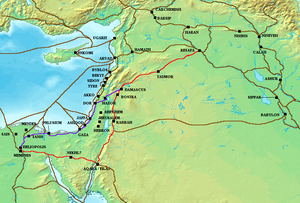
Incense Route
The Incense Route served as a channel for trading of Indian, Arabian and East Asian goods. The incense trade flourished from South Arabia to the Mediterranean between roughly the 3rd century BCE to the 2nd century CE. This trade was crucial to the economy of YemenYemen
The Republic of Yemen , commonly known as Yemen , is a country located in the Middle East, occupying the southwestern to southern end of the Arabian Peninsula. It is bordered by Saudi Arabia to the north, the Red Sea to the west, and Oman to the east....
and the frankincense
Frankincense
Frankincense, also called olibanum , is an aromatic resin obtained from trees of the genus Boswellia, particularly Boswellia sacra, B. carteri, B. thurifera, B. frereana, and B. bhaw-dajiana...
and myrrh
Myrrh
Myrrh is the aromatic oleoresin of a number of small, thorny tree species of the genus Commiphora, which grow in dry, stony soil. An oleoresin is a natural blend of an essential oil and a resin. Myrrh resin is a natural gum....
trees were seen as a source of wealth by the its rulers.
Ptolemy II Philadelphus
Ptolemy II Philadelphus
Ptolemy II Philadelphus was the king of Ptolemaic Egypt from 283 BCE to 246 BCE. He was the son of the founder of the Ptolemaic kingdom Ptolemy I Soter and Berenice, and was educated by Philitas of Cos...
, emperor of Ptolemaic Egypt
Ptolemaic Egypt
Ptolemaic Egypt began when Ptolemy I Soter invaded Egypt and declared himself Pharaoh of Egypt in 305 BC and ended with the death of queen Cleopatra VII of Egypt and the Roman conquest in 30 BC. The Ptolemaic Kingdom was a powerful Hellenistic state, extending from southern Syria in the east, to...
, may have forged an alliance with the Lihyan
Lihyan
Lihyan is an ancient Arab kingdom. It was located in northwestern Arabia, and is known for its Old North Arabian inscriptions dating to ca...
ites in order to secure the incense route at Dedan
Al-`Ula
The Al-`Ula oasis , some 110 km southwest of Tayma in northwestern Arabia was located at the incense route.It was the capital of the ancient Lihyanites...
, thereby rerouting the incense trade from Dedan to the coast along the Red Sea to Egypt. I. E. S. Edwards connects the Syro-Ephraimite War
Syro-Ephraimite War
The Syro-Ephraimite War took place in the 8th century BC, when Assyria was a great regional power. The smaller nations of Syria and the northern Kingdom of Israel formed a coalition in defense against the oncoming threat. They had previously been tributary nations to Assyria, and they finally...
to the desire of the Israelites and the Aramaeans
Aramaeans
The Aramaeans, also Arameans , were a Northwest Semitic semi-nomadic and pastoralist people who originated in what is now modern Syria during the Late Bronze Age and the Iron Age...
to control the northern end of the Incense route, which ran up from Southern Arabia and could be tapped by commanding Transjordan
Transjordan
The Emirate of Transjordan was a former Ottoman territory in the Southern Levant that was part of the British Mandate of Palestine...
.
Gerrha
Gerrha
Gerrha , was an ancient city of Arabia, on the west side of the Persian Gulf. More accurately, the ancient city of Gerrha has been determined to have existed near or under the present fort of Uqair. This fort is 50 miles northeast of Al-Hasa in the Eastern Province of Saudi Arabia...
- inhabited by Chaldea
Chaldea
Chaldea or Chaldaea , from Greek , Chaldaia; Akkadian ; Hebrew כשדים, Kaśdim; Aramaic: ܟܐܠܕܘ, Kaldo) was a marshy land located in modern-day southern Iraq which came to briefly rule Babylon...
n exiles from Babylon
Babylon
Babylon was an Akkadian city-state of ancient Mesopotamia, the remains of which are found in present-day Al Hillah, Babil Province, Iraq, about 85 kilometers south of Baghdad...
- controlled the Incense trade routes across Arabia to the Mediterranean and exercised control over the trading of aromatics to Babylon in the 1st century BC. The Nabateans exercised control over the routes along the Incense Route, and their hold was challenged - without success - by Antigonus Cyclops, emperor of Syria. The Nabatean control over trade further increased and spread in many directions.
The replacement of Greece by the Roman empire
Roman Empire
The Roman Empire was the post-Republican period of the ancient Roman civilization, characterised by an autocratic form of government and large territorial holdings in Europe and around the Mediterranean....
as the administrator of the Mediterranean basin led to the resumption of direct trade with the East and the elimination of the taxes extracted previously by the middlemen of the south. According to Milo Kearney (2003) "The South Arabs in protest took to pirate attacks over the Roman ships in the Gulf of Aden
Gulf of Aden
The Gulf of Aden is located in the Arabian Sea between Yemen, on the south coast of the Arabian Peninsula, and Somalia in the Horn of Africa. In the northwest, it connects with the Red Sea through the Bab-el-Mandeb strait, which is about 20 miles wide....
. In response, the Romans destroyed Aden and favored the Western Abyssinian coast of the Red Sea." Indian ships sailed to Egypt as the maritime routes of Southern Asia were not under the control of a single power.
Pre-Columbian trade
Some similarities between the MesoamericaMesoamerica
Mesoamerica is a region and culture area in the Americas, extending approximately from central Mexico to Belize, Guatemala, El Salvador, Honduras, Nicaragua, and Costa Rica, within which a number of pre-Columbian societies flourished before the Spanish colonization of the Americas in the 15th and...
n and the Andean cultures suggest that the two regions became a part of a wider world system, as a result of trade, by the 1st millennium BCE. The current academic view is that the flow of goods across the Andean slopes was controlled by institutions distributing locations to local groups, who were then free to access them for trading. This trade across the Andean slopes - described sometimes as "vertical trade" - may have overshadowed the long distance trade between the people of the Andes and the neighboring forests. The Callawaya herbalists traded in tropical plants between 6th and the 10th centuries, while copper was dealt by specialized merchants in the Peru
Peru
Peru , officially the Republic of Peru , is a country in western South America. It is bordered on the north by Ecuador and Colombia, on the east by Brazil, on the southeast by Bolivia, on the south by Chile, and on the west by the Pacific Ocean....
vian valley of Chincha
Chincha
The Chincha were a Native American people of the Andes. They are discussed by Maria Rostworowski de Diez Canseco in "History of the Inca Realm" and by Justo Caceres Macedo in "Prehispanic Cultures of Peru"...
. Long distance trade may have seen local elites resorting to struggle in order for manipulation and control.
Prior to the Inca dominance, specialized long distance merchants provided the highlanders with goods such as gold nuggets, copper hatches, cocoa, salt etc. for redistribution among the locals, and were key players in the politics of the region. Hatchet shaped copper currency was produced by the Peruvian people
Peruvian people
Peru is a multiethnic country formed by the combination of different groups over five centuries, so people in Peru usually treat their nationality as a citizenship rather than an ethnicity. Amerindians inhabited Peruvian territory for several millennia before Spanish Conquest in the 16th century;...
, in order to obtain valuables from pre Columbian Ecuador
Ecuador
Ecuador , officially the Republic of Ecuador is a representative democratic republic in South America, bordered by Colombia on the north, Peru on the east and south, and by the Pacific Ocean to the west. It is one of only two countries in South America, along with Chile, that do not have a border...
. A maritime exchange system stretched from the west coast of Mexico to southernmost Peru, trading mostly in Spondylus
Spondylus
Spondylus is a genus of bivalve molluscs, the only genus in the family Spondylidae. As well as being the systematic or scientific name, Spondylus is also the most often used common name for these animals, though they are also known as thorny oysters or spiny oysters.There are many species of...
, which represented rain, fertility and was considered the principal food of the gods by the people of the Inca empire
Inca Empire
The Inca Empire, or Inka Empire , was the largest empire in pre-Columbian America. The administrative, political and military center of the empire was located in Cusco in modern-day Peru. The Inca civilization arose from the highlands of Peru sometime in the early 13th century...
. Spondylus was used in elite rituals and the effective redistribution of it had political effect in the Andes during the pre-Hispanic times.
Silk Route
Eastern world
__FORCETOC__The term Eastern world refers very broadly to the various cultures or social structures and philosophical systems of Eastern Asia or geographically the Eastern Culture...
and the Western world
Western world
The Western world, also known as the West and the Occident , is a term referring to the countries of Western Europe , the countries of the Americas, as well all countries of Northern and Central Europe, Australia and New Zealand...
s. According to Vadime Elisseeff (2000):
"Along the Silk Roads, technology traveled, ideas were exchanged, and friendship and understanding between East and West were experienced for the first time on a large scale. Easterners were exposed to Western ideas and life-styles, and Westerners too, learned about Eastern culture and its spirituality-oriented cosmology. BuddhismBuddhismBuddhism is a religion and philosophy encompassing a variety of traditions, beliefs and practices, largely based on teachings attributed to Siddhartha Gautama, commonly known as the Buddha . The Buddha lived and taught in the northeastern Indian subcontinent some time between the 6th and 4th...
as an Eastern religion received international attention through the Silk Roads."
Cultural interactions patronized often by powerful emperors, such as Kanishka
Kanishka
Kanishka ) was an emperor of the Kushan Empire, ruling an empire extending from Bactria to large parts of northern India in the 2nd century of the common era, and famous for his military, political, and spiritual achievements...
, led to development of art due to introduction of a rich variety of influences. Buddhist missions
Silk Road transmission of Buddhism
The Silk Road transmission of Buddhism to China is most commonly thought to have started in the late 2nd or the 1st century CE.The first documented translation efforts by Buddhist monks in China were in the 2nd century CE, possibly as a consequence of the expansion of the Kushan Empire into the...
thrived along the Silk Roads, partly due to the conducive intermixing of trade and cultural values, which created a series of safe stoppages for both the pilgrims and the traders. Among the frequented routes of the Silk Route was the Burmese
Myanmar
Burma , officially the Republic of the Union of Myanmar , is a country in Southeast Asia. Burma is bordered by China on the northeast, Laos on the east, Thailand on the southeast, Bangladesh on the west, India on the northwest, the Bay of Bengal to the southwest, and the Andaman Sea on the south....
route extending from Bhamo
Bhamo
Bhamo is a city of Kachin State in northernmost part of Myanmar, located 186 km south from the capital city of Myitkyina. It is on the Ayeyarwady River. It lies within 65 km of the border with Yunnan Province, China. The population consists of Chinese and Shan, with Kachin peoples in...
, which served as a path for Marco Polo
Marco Polo
Marco Polo was a Venetian merchant traveler from the Venetian Republic whose travels are recorded in Il Milione, a book which did much to introduce Europeans to Central Asia and China. He learned about trading whilst his father and uncle, Niccolò and Maffeo, travelled through Asia and apparently...
's visit to Yunnan
Yunnan
Yunnan is a province of the People's Republic of China, located in the far southwest of the country spanning approximately and with a population of 45.7 million . The capital of the province is Kunming. The province borders Burma, Laos, and Vietnam.Yunnan is situated in a mountainous area, with...
and Indian Buddhist missions to Canton
Guangzhou
Guangzhou , known historically as Canton or Kwangchow, is the capital and largest city of the Guangdong province in the People's Republic of China. Located in southern China on the Pearl River, about north-northwest of Hong Kong, Guangzhou is a key national transportation hub and trading port...
in order to establish Buddhist monasteries. This route - often under the presence of hostile tribes - also finds mention in the works of Rashid-al-Din Hamadani.
Grand Trunk Road
The Grand Trunk Road - connecting Calcutta in India to Peshawar
Peshawar
Peshawar is the capital of Khyber-Pakhtunkhwa and the administrative center and central economic hub for the Federally Administered Tribal Areas of Pakistan....
in Pakistan - has existed for over two and a half millennia. One of the important trade routes of the world, this road has been a strategic artery with fortresses, halting posts, well
Water well
A water well is an excavation or structure created in the ground by digging, driving, boring or drilling to access groundwater in underground aquifers. The well water is drawn by an electric submersible pump, a trash pump, a vertical turbine pump, a handpump or a mechanical pump...
s, post office
Post office
A post office is a facility forming part of a postal system for the posting, receipt, sorting, handling, transmission or delivery of mail.Post offices offer mail-related services such as post office boxes, postage and packaging supplies...
s, milestone
Milestone
A milestone is one of a series of numbered markers placed along a road or boundary at intervals of one mile or occasionally, parts of a mile. They are typically located at the side of the road or in a median. They are alternatively known as mile markers, mileposts or mile posts...
s and other facilities. Part of this road through Pakistan also coincided with the Silk Road.
This highway has been associated with emperors Chandragupta Maurya
Chandragupta Maurya
Chandragupta Maurya , was the founder of the Maurya Empire. Chandragupta succeeded in conquering most of the Indian subcontinent. Chandragupta is considered the first unifier of India and its first genuine emperor...
and Sher Shah Suri
Sher Shah Suri
Sher Shah Suri , birth name Farid Khan, also known as Sher Khan , was the founder of the short-lived Sur Empire in northern India, with its capital at Delhi, before its demise in the hands of the resurgent Mughal Empire...
, the latter became synonymous with this route due to his role in ensuring the safety of the travelers and the upkeep of the road. Emperor Sher Shah widened and realigned the road to other routes, and provided approximately 1700 roadside inns through his empire. These inns provided free food and lodgings to the travelers regardless of their status.
The British occupation of this road was of special significance for the British Raj
British Raj
British Raj was the British rule in the Indian subcontinent between 1858 and 1947; The term can also refer to the period of dominion...
in India. Bridges, pathways and newer inns were constructed by the British for the first thirty seven years of their reign since the occupation of Punjab
Punjab region
The Punjab , also spelled Panjab |water]]s"), is a geographical region straddling the border between Pakistan and India which includes Punjab province in Pakistan and the states of the Punjab, Haryana, Himachal Pradesh, Chandigarh and some northern parts of the National Capital Territory of Delhi...
in 1849. The British followed roughly the same alignment as the old routes, and at some places the newer routes ran parallel to the older routes.
Vadime Elisseeff (2000) comments on the Grand Trunk Road:
"Along this road marched not only the mighty armies of conquerors, but also the caravans of traders, scholars, artists, and common folk. Together with people, moved ideas, languages, customs, and cultures, not just in one, but in both directions. At different meeting places - permanent as well as temporary - people of different origins and from different cultural backgrounds, professing different faiths and creeds, eating different foods, wearing different clothes, and speaking different languages and dialects would meet one another peacefully. They would understand one another's food, dress, manner, and etiquette, and even borrow words, phrases, idioms and, at times, whole languages from others."
Amber Road
The Amber Road was a European trade route associated with the trade and transport of amber
Amber
Amber is fossilized tree resin , which has been appreciated for its color and natural beauty since Neolithic times. Amber is used as an ingredient in perfumes, as a healing agent in folk medicine, and as jewelry. There are five classes of amber, defined on the basis of their chemical constituents...
. Amber satisfied the criteria for long distance trade as it was light in weight and was in high demand for ornamental purposes around the Mediterranean. Before the establishment of Roman control over areas such as Pannonia
Pannonia
Pannonia was an ancient province of the Roman Empire bounded north and east by the Danube, coterminous westward with Noricum and upper Italy, and southward with Dalmatia and upper Moesia....
, the Amber Road was virtually the only route available for long distance trade.
Towns along the Amber Road began to rise steadily during the 1st century CE, despite the troop movements under Titus Flavius Vespasianus
Vespasian
Vespasian , was Roman Emperor from 69 AD to 79 AD. Vespasian was the founder of the Flavian dynasty, which ruled the Empire for a quarter century. Vespasian was descended from a family of equestrians, who rose into the senatorial rank under the Emperors of the Julio-Claudian dynasty...
and his son Titus Flavius Domitianus
Domitian
Domitian was Roman Emperor from 81 to 96. Domitian was the third and last emperor of the Flavian dynasty.Domitian's youth and early career were largely spent in the shadow of his brother Titus, who gained military renown during the First Jewish-Roman War...
.
Under the reign of Tiberius Caesar Augustus
Tiberius
Tiberius , was Roman Emperor from 14 AD to 37 AD. Tiberius was by birth a Claudian, son of Tiberius Claudius Nero and Livia Drusilla. His mother divorced Nero and married Augustus in 39 BC, making him a step-son of Octavian...
, the Amber Road was straightened and paved according to the prevailing urban standards. Roman towns began to appear along the road, initially founded near the site of Celtic oppida.
The 3rd century saw the Danube
Danube
The Danube is a river in the Central Europe and the Europe's second longest river after the Volga. It is classified as an international waterway....
river become the principal artery of trade, eclipsing the Amber Road and other commercial routes. The redirection of investment to the Danubian forts saw the towns along the Amber Road growing slowly, though yet retaining their prosperity. The prolonged struggle between the Romans and the barbarians further left its mark on the towns along the Amber Road.
Via Maris
Via Maris, literally Latin
Latin
Latin is an Italic language originally spoken in Latium and Ancient Rome. It, along with most European languages, is a descendant of the ancient Proto-Indo-European language. Although it is considered a dead language, a number of scholars and members of the Christian clergy speak it fluently, and...
for "the way of the sea," was an ancient highway used by the Romans and the Crusaders
Crusaders
The Crusaders are a New Zealand professional rugby union team based in Christchurch that competes in the Super Rugby competition. They are the most successful team in Super Rugby history with seven titles...
. The states controlling the Via Maris were in a position to grant access for trade to their own citizens and collect tolls from the outsiders to maintain the trade route. The name Via Maris is a Latin translation of a Hebrew phrase related to Isaiah
Isaiah
Isaiah ; Greek: ', Ēsaïās ; "Yahu is salvation") was a prophet in the 8th-century BC Kingdom of Judah.Jews and Christians consider the Book of Isaiah a part of their Biblical canon; he is the first listed of the neviim akharonim, the later prophets. Many of the New Testament teachings of Jesus...
. Due to the Biblical significance of this ancient route, many attempts to find its present day location have been made by Christian
Christian
A Christian is a person who adheres to Christianity, an Abrahamic, monotheistic religion based on the life and teachings of Jesus of Nazareth as recorded in the Canonical gospels and the letters of the New Testament...
pilgrims. 13th century traveler and pilgrim Burchard of Mount Zion
Mount Zion
Mount Zion is a place name for a site in Jerusalem, the location of which has shifted several times in history. According to the Hebrew Bible's Book of Samuel, it was the site of the Jebusite fortress called the "stronghold of Zion" that was conquered by King David, becoming his palace in the City...
refers to the Via Maris route as a way leading along the shore of the Sea of Galilee
Sea of Galilee
The Sea of Galilee, also Kinneret, Lake of Gennesaret, or Lake Tiberias , is the largest freshwater lake in Israel, and it is approximately in circumference, about long, and wide. The lake has a total area of , and a maximum depth of approximately 43 m...
.
Trans Saharan trade
Early Muslim writings confirm that the people of West AfricaWest Africa
West Africa or Western Africa is the westernmost region of the African continent. Geopolitically, the UN definition of Western Africa includes the following 16 countries and an area of approximately 5 million square km:-Flags of West Africa:...
operated a sophisticated network of trade, usually under the authority of a monarch who levied taxes and provided bureaucratic and military support to his kingdom. Sophisticated mechanisms for the economic and political development of the involved African areas were in place before Islam
Islam
Islam . The most common are and . : Arabic pronunciation varies regionally. The first vowel ranges from ~~. The second vowel ranges from ~~~...
further strengthened trade, towns and government in western Africa. The capital, court and trade of the region find mention in the works of scholar Abū 'Ubayd 'Abd Allāh al-Bakrī; the mainstay of the trans Saharan
Saharan
The term Saharan is used in the English language to denote someone or something from the Sahara desert, including:* Sahrawi , referring to the people of the Western Sahara* Saharan languages, a subgroup of the Nilo-Saharan languages...
trade was gold and salt.
The powerful Saharan tribes, Berber
Berber people
Berbers are the indigenous peoples of North Africa west of the Nile Valley. They are continuously distributed from the Atlantic to the Siwa oasis, in Egypt, and from the Mediterranean to the Niger River. Historically they spoke the Berber language or varieties of it, which together form a branch...
in origin and later adapting to Muslim and Arab cultures, controlled the channels to western Africa by making efficient use of horse-drawn vehicles and pack animals. The Songhai engaged in a struggle against the Sa'di dynasty of Morocco
Morocco
Morocco , officially the Kingdom of Morocco , is a country located in North Africa. It has a population of more than 32 million and an area of 710,850 km², and also primarily administers the disputed region of the Western Sahara...
over the control of the trans Saharan trade, resulting in damage on both sides and a weak Moroccan victory, further strengthening the uninvolved Saharan tribes. Struggles and disturbances continued till the 14th century, by which the Mandé merchants were trading with the Hausa
Hausa people
The Hausa are one of the largest ethnic groups in West Africa. They are a Sahelian people chiefly located in northern Nigeria and southeastern Niger, but having significant numbers living in regions of Cameroon, Ghana, Cote d'Ivoire, Chad and Sudan...
, between Lake Chad
Lake Chad
Lake Chad is a historically large, shallow, endorheic lake in Africa, whose size has varied over the centuries. According to the Global Resource Information Database of the United Nations Environment Programme, it shrank as much as 95% from about 1963 to 1998; yet it also states that "the 2007 ...
and the Niger
Niger
Niger , officially named the Republic of Niger, is a landlocked country in Western Africa, named after the Niger River. It borders Nigeria and Benin to the south, Burkina Faso and Mali to the west, Algeria and Libya to the north and Chad to the east...
. Newer trade routes developed following extension of trade.
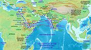
Roman-India routes
Ptolemaic dynasty
The Ptolemaic dynasty, was a Macedonian Greek royal family which ruled the Ptolemaic Empire in Egypt during the Hellenistic period. Their rule lasted for 275 years, from 305 BC to 30 BC...
had initiated Greco-Roman maritime trade contact with India using the Red Sea ports. The Roman historian Strabo
Strabo
Strabo, also written Strabon was a Greek historian, geographer and philosopher.-Life:Strabo was born to an affluent family from Amaseia in Pontus , a city which he said was situated the approximate equivalent of 75 km from the Black Sea...
mentions a vast increase in trade following the Roman annexation of Egypt, indicating that monsoon was known and manipulated for trade in his time. By the time of Augustus
Augustus
Augustus ;23 September 63 BC – 19 August AD 14) is considered the first emperor of the Roman Empire, which he ruled alone from 27 BC until his death in 14 AD.The dates of his rule are contemporary dates; Augustus lived under two calendars, the Roman Republican until 45 BC, and the Julian...
up to 120 ships were setting sail every year from Myos Hormos
Myos Hormos
Myos Hormos was a Red Sea port constructed by the Ptolemies around the 3rd century BC. Following excavations carried out recently by David Peacock and Lucy Blue of the University of Southampton, it is thought to have been located on the present-day site of Quseir al-Quadim , eight kilometres north...
to India, trading in a diverse variety of goods. Arsinoe
Arsinoe
Arsinoe , sometimes spelled Arsinoë, pronounced Arsinoi in modern Greek, may refer to:-Literature:* Arsinoe, a character in Le Misanthrope, a play by French playwright Molière...
, Berenice Troglodytica and Myos Hormos were the principal Roman ports involved in this maritime trading network, while the Indian ports included Barbaricum, Barygaza
Bharuch
Bharuch , also known as Broach, is the oldest city in Gujarat, situated at the mouth of the holy river Narmada. Bharuch is the administrative headquarters of Bharuch District and a municipality of more than 1,50,000 inhabitants. As Bharuch is a major seaport city, a number of trade activities have...
, Muziris
Muziris
Muziris is an ancient sea-port in Southwestern India on the Periyar River 3.2 km from its mouth. The derivation of the name Muziris is said to be from "Mucciripattanam," "mucciri" means "cleft palate" and "pattanam" means "city". Near Muziris, Periyar River was branched into two like a...
and Arikamedu
Arikamedu
Arikamedu is an archaeological site near Pondicherry, southern India, where Mortimer Wheeler conducted his best-known excavation in the 1940s. According to Wheeler, Arikamedu was a Tamil fishing village which was formerly a major Chola port dedicated to bead making and trading with Roman traders...
.
The Indians were present in Alexandria
Alexandria
Alexandria is the second-largest city of Egypt, with a population of 4.1 million, extending about along the coast of the Mediterranean Sea in the north central part of the country; it is also the largest city lying directly on the Mediterranean coast. It is Egypt's largest seaport, serving...
and the Christian and Jewish settlers from Rome continued to live in India long after the fall of the Roman empire, which resulted in Rome's loss of the Red Sea
Red Sea
The Red Sea is a seawater inlet of the Indian Ocean, lying between Africa and Asia. The connection to the ocean is in the south through the Bab el Mandeb strait and the Gulf of Aden. In the north, there is the Sinai Peninsula, the Gulf of Aqaba, and the Gulf of Suez...
ports, previously used to secure trade with India by the Greco-Roman world since the time of the Ptolemaic dynasty.
Hanseatic trade
Germans
The Germans are a Germanic ethnic group native to Central Europe. The English term Germans has referred to the German-speaking population of the Holy Roman Empire since the Late Middle Ages....
played a relatively modest role in the north European trade. However, this was to change with the development of Hanseatic trade, as a result of which German traders became prominent in the Baltic
Baltic Sea
The Baltic Sea is a brackish mediterranean sea located in Northern Europe, from 53°N to 66°N latitude and from 20°E to 26°E longitude. It is bounded by the Scandinavian Peninsula, the mainland of Europe, and the Danish islands. It drains into the Kattegat by way of the Øresund, the Great Belt and...
and the North Sea
North Sea
In the southwest, beyond the Straits of Dover, the North Sea becomes the English Channel connecting to the Atlantic Ocean. In the east, it connects to the Baltic Sea via the Skagerrak and Kattegat, narrow straits that separate Denmark from Norway and Sweden respectively...
regions. Following the death of Eric VI of Denmark
Eric VI of Denmark
Eric VI Menved was King of Denmark and a son of Eric V and Agnes of Brandenburg.He became king in 1286 at age 12, when his father was murdered 20 November by unknown assailants...
, German forces attacked and sacked Denmark, bringing with them artisans and merchants under the new administration which controlled the Hansa regions. During the third quarter of the 14th century the Hanseatic trade faced two major difficulties: economic conflict with the Flanders
Flanders
Flanders is the community of the Flemings but also one of the institutions in Belgium, and a geographical region located in parts of present-day Belgium, France and the Netherlands. "Flanders" can also refer to the northern part of Belgium that contains Brussels, Bruges, Ghent and Antwerp...
and hostilities with Denmark. These events led to the formation of an organized association of Hanseatic towns, which replaced the earlier union of German merchants. This new Hansa of the towns - aimed at protecting interests of the merchants and trade - became prominent for the next hundred and fifty years.
Philippe Dollinger associates the downfall of the Hansa to a new alliance between Lübeck
Lübeck
The Hanseatic City of Lübeck is the second-largest city in Schleswig-Holstein, in northern Germany, and one of the major ports of Germany. It was for several centuries the "capital" of the Hanseatic League and, because of its Brick Gothic architectural heritage, is listed by UNESCO as a World...
, Hamburg
Hamburg
-History:The first historic name for the city was, according to Claudius Ptolemy's reports, Treva.But the city takes its modern name, Hamburg, from the first permanent building on the site, a castle whose construction was ordered by the Emperor Charlemagne in AD 808...
and Bremen
Bremen
The City Municipality of Bremen is a Hanseatic city in northwestern Germany. A commercial and industrial city with a major port on the river Weser, Bremen is part of the Bremen-Oldenburg metropolitan area . Bremen is the second most populous city in North Germany and tenth in Germany.Bremen is...
, which outshadowed the older institution. He further sets the date of dissolution of the Hansa at 1630 and concludes that the Hansa was almost entirely forgotten by the end of the 18th century. Scholar Georg Friedrich Sartorius
Georg Friedrich Sartorius
Georg Friedrich Sartorius after 1827 Freiherr von Waltershausen was a German research historian, economist and professor at Göttingen University....
published the first monograph
Monograph
A monograph is a work of writing upon a single subject, usually by a single author.It is often a scholarly essay or learned treatise, and may be released in the manner of a book or journal article. It is by definition a single document that forms a complete text in itself...
regarding the community in the early years of the 19th century.
From the Varangians to the Greek
The trade route from the Varangians to the Greeks (Russian: Путь «из варяг в греки», Put iz varyag v greki, Swedish: Vägen från varjagerna till grekerna, Greek: Εμπορική Οδός Βαράγγων - Ελλήνων) was a trade route that connected Scandinavia, Kievan Rus' and the Byzantine Empire. The route allowed traders along the route to establish a direct prosperous trade with Byzantium, and prompted some of them to settle in the territories of present-day Belarus, Russia and Ukraine.The route began in Scandinavian trading centres such as Birka, Hedeby, and Gotland, crossed the Baltic Sea entered the Gulf of Finland, followed the Neva River into the Lake Ladoga. Then it followed the Volkhov River, upstream past the towns of Staraya Ladoga and Velikiy Novgorod, crossed Lake Ilmen, and up the Lovat River. From there, ships had to be portaged to the Dnieper River near Gnezdovo. A second route from the Baltic to the Dnieper was along the Western Dvina (Daugava) between the Lovat and the Dnieper in the Smolensk region, and along the Kasplya River to Gnezdovo. Along the Dnieper, the route crossed several major rapids and passed through Kiev, and after entering the Black Sea followed its west coast to Constantinople.
Maritime republics' Mediterranean trade
The economic growth of EuropeEurope
Europe is, by convention, one of the world's seven continents. Comprising the westernmost peninsula of Eurasia, Europe is generally 'divided' from Asia to its east by the watershed divides of the Ural and Caucasus Mountains, the Ural River, the Caspian and Black Seas, and the waterways connecting...
around the year 1000, together with the lack of safety on the mainland trading routes, eased the development of major commercial routes along the coast of the Mediterranean
Mediterranean Sea
The Mediterranean Sea is a sea connected to the Atlantic Ocean surrounded by the Mediterranean region and almost completely enclosed by land: on the north by Anatolia and Europe, on the south by North Africa, and on the east by the Levant...
. The growing independence of some coastal cities gave them a leading role in this comerce: Maritime Republics (Italian "Repubbliche Marinare") of Venice
Republic of Venice
The Republic of Venice or Venetian Republic was a state originating from the city of Venice in Northeastern Italy. It existed for over a millennium, from the late 7th century until 1797. It was formally known as the Most Serene Republic of Venice and is often referred to as La Serenissima, in...
, Genoa
Republic of Genoa
The Most Serene Republic of Genoa |Ligurian]]: Repúbrica de Zêna) was an independent state from 1005 to 1797 in Liguria on the northwestern Italian coast, as well as Corsica from 1347 to 1768, and numerous other territories throughout the Mediterranean....
, Amalfi
Amalfi
Amalfi is a town and comune in the province of Salerno, in the region of Campania, Italy, on the Gulf of Salerno, c. 35 km southeast of Naples. It lies at the mouth of a deep ravine, at the foot of Monte Cerreto , surrounded by dramatic cliffs and coastal scenery...
, Pisa
Pisa
Pisa is a city in Tuscany, Central Italy, on the right bank of the mouth of the River Arno on the Tyrrhenian Sea. It is the capital city of the Province of Pisa...
and Republic of Ragusa
Republic of Ragusa
The Republic of Ragusa or Republic of Dubrovnik was a maritime republic centered on the city of Dubrovnik in Dalmatia , that existed from 1358 to 1808...
developed their own "empires" in the Mediterranean shores.
From the 8th until the 15th century, they held the monopoly of European trade with the Middle East. The silk
Silk Road
The Silk Road or Silk Route refers to a historical network of interlinking trade routes across the Afro-Eurasian landmass that connected East, South, and Western Asia with the Mediterranean and European world, as well as parts of North and East Africa...
and spice trade
Spice trade
Civilizations of Asia were involved in spice trade from the ancient times, and the Greco-Roman world soon followed by trading along the Incense route and the Roman-India routes...
, involving spice
Spice
A spice is a dried seed, fruit, root, bark, or vegetative substance used in nutritionally insignificant quantities as a food additive for flavor, color, or as a preservative that kills harmful bacteria or prevents their growth. It may be used to flavour a dish or to hide other flavours...
s, incense
Incense
Incense is composed of aromatic biotic materials, which release fragrant smoke when burned. The term "incense" refers to the substance itself, rather than to the odor that it produces. It is used in religious ceremonies, ritual purification, aromatherapy, meditation, for creating a mood, and for...
, herb
Herb
Except in botanical usage, an herb is "any plant with leaves, seeds, or flowers used for flavoring, food, medicine, or perfume" or "a part of such a plant as used in cooking"...
s, drug
Drug
A drug, broadly speaking, is any substance that, when absorbed into the body of a living organism, alters normal bodily function. There is no single, precise definition, as there are different meanings in drug control law, government regulations, medicine, and colloquial usage.In pharmacology, a...
s and opium
Opium
Opium is the dried latex obtained from the opium poppy . Opium contains up to 12% morphine, an alkaloid, which is frequently processed chemically to produce heroin for the illegal drug trade. The latex also includes codeine and non-narcotic alkaloids such as papaverine, thebaine and noscapine...
, made these Mediterranean city-states phenomenally rich. Spices were among the most expensive and demanded products of the Middle Ages. They were all imported from Asia and Africa. Muslim traders—mainly descendants of Arab sailors from Yemen
Yemen
The Republic of Yemen , commonly known as Yemen , is a country located in the Middle East, occupying the southwestern to southern end of the Arabian Peninsula. It is bordered by Saudi Arabia to the north, the Red Sea to the west, and Oman to the east....
and Oman
Oman
Oman , officially called the Sultanate of Oman , is an Arab state in southwest Asia on the southeast coast of the Arabian Peninsula. It is bordered by the United Arab Emirates to the northwest, Saudi Arabia to the west, and Yemen to the southwest. The coast is formed by the Arabian Sea on the...
—dominated maritime routes throughout the Indian Ocean, tapping source regions in the Far East
Far East
The Far East is an English term mostly describing East Asia and Southeast Asia, with South Asia sometimes also included for economic and cultural reasons.The term came into use in European geopolitical discourse in the 19th century,...
and shipping for trading emporiums in India, westward to Ormus
Ormus
The Kingdom of Ormus was a 10th to 17th century kingdom located within the Persian Gulf and extending as far as the Strait of Hormuz...
in Persian Gulf
Persian Gulf
The Persian Gulf, in Southwest Asia, is an extension of the Indian Ocean located between Iran and the Arabian Peninsula.The Persian Gulf was the focus of the 1980–1988 Iran-Iraq War, in which each side attacked the other's oil tankers...
and Jeddah
Jeddah
Jeddah, Jiddah, Jidda, or Jedda is a city located on the coast of the Red Sea and is the major urban center of western Saudi Arabia. It is the largest city in Makkah Province, the largest sea port on the Red Sea, and the second largest city in Saudi Arabia after the capital city, Riyadh. The...
in the Red Sea
Red Sea
The Red Sea is a seawater inlet of the Indian Ocean, lying between Africa and Asia. The connection to the ocean is in the south through the Bab el Mandeb strait and the Gulf of Aden. In the north, there is the Sinai Peninsula, the Gulf of Aqaba, and the Gulf of Suez...
. From there, overland routes led to the Mediterranean coasts. Venetian merchants distributed then the goods through Europe until the rise of the Ottoman Empire
Ottoman Empire
The Ottoman EmpireIt was usually referred to as the "Ottoman Empire", the "Turkish Empire", the "Ottoman Caliphate" or more commonly "Turkey" by its contemporaries...
, that eventually led to the fall of Constantinople
Fall of Constantinople
The Fall of Constantinople was the capture of the capital of the Byzantine Empire, which occurred after a siege by the Ottoman Empire, under the command of Ottoman Sultan Mehmed II, against the defending army commanded by Byzantine Emperor Constantine XI...
in 1453, barring Europeans from important combined-land-sea routes.
Spice Route
As trade between India and the Greco-Roman worldGreco-Roman world
The Greco-Roman world, Greco-Roman culture, or the term Greco-Roman , when used as an adjective, as understood by modern scholars and writers, refers to those geographical regions and countries that culturally were directly, protractedly and intimately influenced by the language, culture,...
increased spices became the main import from India to the Western world, bypassing silk and other commodities. The Indian commercial connection with South East Asia proved vital to the merchants of Arabia and Persia during the 7th century and the 8th century.
The Abbasids used Alexandria, Damietta
Damietta
Damietta , also known as Damiata, or Domyat, is a port and the capital of the Damietta Governorate in Egypt. It is located at the intersection between the Mediterranean Sea and the Nile, about north of Cairo.-History:...
, Aden
Aden
Aden is a seaport city in Yemen, located by the eastern approach to the Red Sea , some 170 kilometres east of Bab-el-Mandeb. Its population is approximately 800,000. Aden's ancient, natural harbour lies in the crater of an extinct volcano which now forms a peninsula, joined to the mainland by a...
and Siraf
Siraf
Siraf is a city in the Central District of Kangan County, Bushehr Province, Iran. At the 2006 census, its population was 3,500, in 722 families....
as entry ports to India and China. Merchants arriving from India in the port city of Aden paid tribute in form of musk
Musk
Musk is a class of aromatic substances commonly used as base notes in perfumery. They include glandular secretions from animals such as the musk deer, numerous plants emitting similar fragrances, and artificial substances with similar odors. Musk was a name originally given to a substance with a...
, camphor
Camphor
Camphor is a waxy, white or transparent solid with a strong, aromatic odor. It is a terpenoid with the chemical formula C10H16O. It is found in wood of the camphor laurel , a large evergreen tree found in Asia and also of Dryobalanops aromatica, a giant of the Bornean forests...
, ambergris
Ambergris
Ambergris is a solid, waxy, flammable substance of a dull gray or blackish color produced in the digestive system of and regurgitated or secreted by sperm whales....
and sandalwood to Ibn Ziyad, the sultan
Sultan
Sultan is a title with several historical meanings. Originally, it was an Arabic language abstract noun meaning "strength", "authority", "rulership", and "dictatorship", derived from the masdar سلطة , meaning "authority" or "power". Later, it came to be used as the title of certain rulers who...
of Yemen. Moluccan products shipped across the ports of Arabia to the Near East passed through the ports of India and Sri Lanka
Sri Lanka
Sri Lanka, officially the Democratic Socialist Republic of Sri Lanka is a country off the southern coast of the Indian subcontinent. Known until 1972 as Ceylon , Sri Lanka is an island surrounded by the Indian Ocean, the Gulf of Mannar and the Palk Strait, and lies in the vicinity of India and the...
. Indian exports of spices find mention in the works of Ibn Khurdadhbeh (850), al-Ghafiqi (1150 AD), Ishak bin Imaran (907) and Al Kalkashandi (14th century). After reaching either the Indian or the Sri Lankan ports, spices were sometimes shipped to East Africa, where they were used for many purposes, including burial rites.
On the orders of Manuel I of Portugal
Manuel I of Portugal
Manuel I , the Fortunate , 14th king of Portugal and the Algarves was the son of Infante Ferdinand, Duke of Viseu, , by his wife, Infanta Beatrice of Portugal...
, four vessels under the command of navigator Vasco da Gama rounded the Cape of Good Hope
Cape of Good Hope
The Cape of Good Hope is a rocky headland on the Atlantic coast of the Cape Peninsula, South Africa.There is a misconception that the Cape of Good Hope is the southern tip of Africa, because it was once believed to be the dividing point between the Atlantic and Indian Oceans. In fact, the...
, continuing to the eastern coast of Africa to Malindi
Malindi
Malindi is a town on Malindi Bay at the mouth of the Galana River, lying on the Indian Ocean coast of Kenya. It is 120 kilometres northeast of Mombasa. The population of Malindi is 117,735 . It is the capital of the Malindi District.Tourism is the major industry in Malindi. The city is...
to sail across the Indian Ocean to Calicut
History of Kozhikode
Kozhikode , also known as Calicut, is a city in the southern Indian state of Kerala. It is the third largest city in Kerala and the headquarters of Kozhikode district....
. The wealth of the Indies
Indies
The Indies is a term that has been used to describe the lands of South and Southeast Asia, occupying all of the present India, Pakistan, Bangladesh, Myanmar, Nepal, Sri Lanka, the Maldives, and also Thailand, Cambodia, Laos, Vietnam, Brunei, Singapore, the Philippines, East Timor, Malaysia and...
was now open for the Europeans to explore; the Portuguese Empire
Portuguese Empire
The Portuguese Empire , also known as the Portuguese Overseas Empire or the Portuguese Colonial Empire , was the first global empire in history...
I was one of the early European empires to grow from spice trade.
Modern routes
The modern times saw development of newer means of transport and often controversial free trade agreements, which altered the political and logistical approach prevalent during the Middle Ages. Newer means of transport led to the establishment of new routes, and countries opened up borders to allow trade in mutually agreed goods as per the prevailing free trade agreement. Some old trading route were reopened during the modern times, although in different political and logistical scenarios. The entry of harmful foreign pollutants by the way of trade routes has been a cause of alarm during the modern times. A conservative estimate stresses that future damages from harmful animal and plant diseases may be as high as 134 billion US dollars in the absence of effective measures to prevent the introduction of unwanted pests through various trade routes.Wagonway routes
Networks, like the Santa Fe TrailSanta Fe Trail
The Santa Fe Trail was a 19th-century transportation route through central North America that connected Missouri with Santa Fe, New Mexico. Pioneered in 1822 by William Becknell, it served as a vital commercial and military highway until the introduction of the railroad to Santa Fe in 1880...
and the Oregon Trail
Oregon Trail
The Oregon Trail is a historic east-west wagon route that connected the Missouri River to valleys in Oregon and locations in between.After 1840 steam-powered riverboats and steamboats traversing up and down the Ohio, Mississippi and Missouri rivers sped settlement and development in the flat...
, became prominent in the United States with wagon train
Wagon train
A wagon train is a group of wagons traveling together. In the American West, individuals traveling across the plains in covered wagons banded together for mutual assistance, as is reflected in numerous films and television programs about the region, such as Audie Murphy's Tumbleweed and Ward Bond...
s gaining popularity as a mode of long distance overland transportation for both people and goods. The Oregon
Oregon
Oregon is a state in the Pacific Northwest region of the United States. It is located on the Pacific coast, with Washington to the north, California to the south, Nevada on the southeast and Idaho to the east. The Columbia and Snake rivers delineate much of Oregon's northern and eastern...
-California
California
California is a state located on the West Coast of the United States. It is by far the most populous U.S. state, and the third-largest by land area...
routes were highly organized with planned rendezvous locations and essential supplies. The settlers in the United States used these wagon trains - sometimes made up of 100 of more Conestoga wagon
Conestoga wagon
The Conestoga wagon is a heavy, broad-wheeled covered wagon that was used extensively during the late 18th century and the 19th century in the United States and sometimes in Canada as well. It was large enough to transport loads up to 8 tons , and was drawn by horses, mules or oxen...
s - for westward emigration during the 18th and the 19th centuries. Among the challenges faced by the wagon route operators were crossing rivers, mountains and hostile Native American
Native Americans in the United States
Native Americans in the United States are the indigenous peoples in North America within the boundaries of the present-day continental United States, parts of Alaska, and the island state of Hawaii. They are composed of numerous, distinct tribes, states, and ethnic groups, many of which survive as...
s. Preparations were also made according to the weather and protection of trade and travelers was ensured by a few guards on horseback.
Wagon freighting was also essential to American growth until it was replaced by the railroad and the truck
Truck
A truck or lorry is a motor vehicle designed to transport cargo. Trucks vary greatly in size, power, and configuration, with the smallest being mechanically similar to an automobile...
.
Railway routes
Train
A train is a connected series of vehicles for rail transport that move along a track to transport cargo or passengers from one place to another place. The track usually consists of two rails, but might also be a monorail or maglev guideway.Propulsion for the train is provided by a separate...
to a station every day with the third class fares priced at a penny
Penny
A penny is a coin or a type of currency used in several English-speaking countries. It is often the smallest denomination within a currency system.-Etymology:...
a mile. Trade benefited as the workers and the lower classes had the ability to travel to other towns frequently. Suburban communities began to develop and towns began to spread outwards. The British constructed a vast railway network in India, but it was considered to serve a strategic purpose in addition to the commercial purpose. The efficient use of rail routes helped in the unification of the United States of America.
The modern times saw nations struggle for the control of rail routes: The Trans-Siberian Railway
Trans-Siberian Railway
The Trans-Siberian Railway is a network of railways connecting Moscow with the Russian Far East and the Sea of Japan. It is the longest railway in the world...
was intended to be used by the Russian government for control of Manchuria
Manchuria
Manchuria is a historical name given to a large geographic region in northeast Asia. Depending on the definition of its extent, Manchuria usually falls entirely within the People's Republic of China, or is sometimes divided between China and Russia. The region is commonly referred to as Northeast...
and later China; the German forces wanted to establish Berlin-Baghdad Railway in order to influence the Near East; and the Austrian government planned a route from Vienna
Vienna
Vienna is the capital and largest city of the Republic of Austria and one of the nine states of Austria. Vienna is Austria's primary city, with a population of about 1.723 million , and is by far the largest city in Austria, as well as its cultural, economic, and political centre...
to Salonika for control of the Balkans
Balkans
The Balkans is a geopolitical and cultural region of southeastern Europe...
.
According to the Encyclopædia Britannica
Encyclopædia Britannica
The Encyclopædia Britannica , published by Encyclopædia Britannica, Inc., is a general knowledge English-language encyclopaedia that is available in print, as a DVD, and on the Internet. It is written and continuously updated by about 100 full-time editors and more than 4,000 expert...
(2002):
Railroads reached their maturity in the early 20th century, as trains carried the bulk of land freight and passenger traffic in the industrialized countries of the world. By the mid-20th century, however, they had lost their preeminent position. The private automobile had replaced the railroad for short passenger trips, while the airplane had usurped it for long-distance travel, especially in the United States. Railroads remained effective, however, for transporting people in high-volume situations, such as commuting between the centres of large cities and their suburbs, and medium-distance travel of less than about 300 miles between urban centres.
Although railroads have lost much of the general-freight-carrying business to semi-trailer trucks, they remain the best means of transporting large volumes of such bulk commodities as coal, grain, chemicals, and ore over long distances. The development of containerizationContainerizationContainerization is a system of freight transport based on a range of steel intermodal containers...
has made the railroads more effective in handling finished merchandise at relatively high speeds. In addition, the introduction of piggyback flatcars, in which truck trailers are transported long distances on specially-designed cars, has allowed railroads to regain some of the business lost to trucking.
Modern road networks
Limited-access road
A limited-access road known by various terms worldwide, including limited-access highway, dual-carriageway and expressway, is a highway or arterial road for high-speed traffic which has many or most characteristics of a controlled-access highway , including limited or no access to adjacent...
, freeways and tollways during the modern times. Existing roads were developed and highways were designed according to intended use.
Truck
Truck
A truck or lorry is a motor vehicle designed to transport cargo. Trucks vary greatly in size, power, and configuration, with the smallest being mechanically similar to an automobile...
s came into widespread use in the Western World during World War I, and quickly gained reputation as a means of long distance transportation of goods. Modern highways, such as the Trans-Canada Highway
Trans-Canada Highway
The Trans-Canada Highway is a federal-provincial highway system that joins the ten provinces of Canada. It is, along with the Trans-Siberian Highway and Australia's Highway 1, one of the world's longest national highways, with the main route spanning 8,030 km...
, Highway 1 (Australia)
Highway 1 (Australia)
Australia's Highway 1 is a network of highways that circumnavigate the Australian continent, joining all mainland state capitals. At a total length of approximately it is the longest national highway in the world, longer than the Trans-Siberian Highway and the Trans-Canada Highway...
and Pan-American Highway
Pan-American Highway
The Pan-American Highway is a network of roads measuring about in total length. Except for an rainforest break, called the Darién Gap, the road links the mainland nations of the Americas in a connected highway system. According to Guinness World Records, the Pan-American Highway is the world's...
allowed transport of goods and services across great distances. Automobiles continue to play a crucial role in the economies of the Industrialized countries, resulting in rise of businesses such as motor freight operation and truck transportation.
The emission rate for cars using highways has been on a decline between 1975 and 1995 due to regulations and the introduction of unleaded petrol. This trend is especially notable since there has been a growth in vehicles and vehicle miles traveled by automobiles using these highways.
Modern maritime routes
Modern maritime trade routes - sometimes in the form of artificial canals like the Suez Canal
Suez Canal
The Suez Canal , also known by the nickname "The Highway to India", is an artificial sea-level waterway in Egypt, connecting the Mediterranean Sea and the Red Sea. Opened in November 1869 after 10 years of construction work, it allows water transportation between Europe and Asia without navigation...
- had visible impact on the economic and political standing of nations. The opening of the Suez Canal altered British interactions with the colonies of the British Empire
British Empire
The British Empire comprised the dominions, colonies, protectorates, mandates and other territories ruled or administered by the United Kingdom. It originated with the overseas colonies and trading posts established by England in the late 16th and early 17th centuries. At its height, it was the...
as the dynamics of transportation, trade and communication had now changed drastically. Other waterways, like the Panama Canal
Panama Canal
The Panama Canal is a ship canal in Panama that joins the Atlantic Ocean and the Pacific Ocean and is a key conduit for international maritime trade. Built from 1904 to 1914, the canal has seen annual traffic rise from about 1,000 ships early on to 14,702 vessels measuring a total of 309.6...
played an important role in the histories of many nations. Inland water transportation remained significantly important even as the advent of railroads and automobiles resulted in a steady decline of canals. Inland water transport is still used for the transportation of bulk commodities e.g. grains, coal, and ore.
Waterway commerce was historically important to Europe, particularly to Russia. According to the Encyclopædia Britannica (2002): "Russia has been a significant beneficiary. Not only have inland waterways opened vast areas of its interior to development, but Moscow-linked to the White
White Sea
The White Sea is a southern inlet of the Barents Sea located on the northwest coast of Russia. It is surrounded by Karelia to the west, the Kola Peninsula to the north, and the Kanin Peninsula to the northeast. The whole of the White Sea is under Russian sovereignty and considered to be part of...
, Baltic
Baltic Sea
The Baltic Sea is a brackish mediterranean sea located in Northern Europe, from 53°N to 66°N latitude and from 20°E to 26°E longitude. It is bounded by the Scandinavian Peninsula, the mainland of Europe, and the Danish islands. It drains into the Kattegat by way of the Øresund, the Great Belt and...
, Black
Black Sea
The Black Sea is bounded by Europe, Anatolia and the Caucasus and is ultimately connected to the Atlantic Ocean via the Mediterranean and the Aegean seas and various straits. The Bosphorus strait connects it to the Sea of Marmara, and the strait of the Dardanelles connects that sea to the Aegean...
, Caspian
Caspian Sea
The Caspian Sea is the largest enclosed body of water on Earth by area, variously classed as the world's largest lake or a full-fledged sea. The sea has a surface area of and a volume of...
, and Azov seas by canals and rivers-has become a major inland port."
Oil spills are recorded both in case of maritime routes and pipeline routes to the main refineries. Oil spills, amounting to as much as 7.56 billion liters of oil entering the oceans every year, occur due to damaged equipment or human error.
Free trade areas
Free trade
Under a free trade policy, prices emerge from supply and demand, and are the sole determinant of resource allocation. 'Free' trade differs from other forms of trade policy where the allocation of goods and services among trading countries are determined by price strategies that may differ from...
became visible in 1860 with the Anglo-French commercial treaty, and the trend gained further momentum during the period after World War II.
According to The Columbia Encyclopedia, Sixth Edition:
"After World War II, strong sentiment developed throughout the world against protection and high tariffs and in favor of freer trade. The results were new organizations and agreements on international trade such as the General Agreement on Tariffs and TradeGeneral Agreement on Tariffs and TradeThe General Agreement on Tariffs and Trade was negotiated during the UN Conference on Trade and Employment and was the outcome of the failure of negotiating governments to create the International Trade Organization . GATT was signed in 1947 and lasted until 1993, when it was replaced by the World...
(1948), the Benelux Economic Union (1948), the European Economic CommunityEuropean Economic CommunityThe European Economic Community The European Economic Community (EEC) The European Economic Community (EEC) (also known as the Common Market in the English-speaking world, renamed the European Community (EC) in 1993The information in this article primarily covers the EEC's time as an independent...
(Common Market, 1957), the European Free Trade AssociationEuropean Free Trade AssociationThe European Free Trade Association or EFTA is a free trade organisation between four European countries that operates parallel to, and is linked to, the European Union . EFTA was established on 3 May 1960 as a trade bloc-alternative for European states who were either unable to, or chose not to,...
(1959), MercosurMercosurMercosur or Mercosul is an economic and political agreement among Argentina, Brazil, Paraguay and Uruguay. Founded in 1991 by the Treaty of Asunción, which was later amended and updated by the 1994 Treaty of Ouro Preto. Its purpose is to promote free trade and the fluid movement of goods, people,...
(the Southern Cone Common Market, 1991), and the World Trade OrganizationWorld Trade OrganizationThe World Trade Organization is an organization that intends to supervise and liberalize international trade. The organization officially commenced on January 1, 1995 under the Marrakech Agreement, replacing the General Agreement on Tariffs and Trade , which commenced in 1948...
(1995). In 1993, the North American Free Trade AgreementNorth American Free Trade AgreementThe North American Free Trade Agreement or NAFTA is an agreement signed by the governments of Canada, Mexico, and the United States, creating a trilateral trade bloc in North America. The agreement came into force on January 1, 1994. It superseded the Canada – United States Free Trade Agreement...
(NAFTA) was approved by the governments of Canada, Mexico, and the United States. In the early 1990s, the nations of the European UnionEuropean UnionThe European Union is an economic and political union of 27 independent member states which are located primarily in Europe. The EU traces its origins from the European Coal and Steel Community and the European Economic Community , formed by six countries in 1958...
(the successor organization to the Common Market) undertook to remove all barriers to the free movement of trade and employment across their mutual borders."
In May 2004 the United States of America signed the American Free trade Agreement with five Central American nations.
Air routes
The national, international and global economies are linked to this mode of transportation, making it vital to many other industries. Newer trends of liberalization of trade have further led to establishment of routes among nations bound by agreements. One such example is the American Open Skies policy
Open skies
Open skies is an international policy concept which calls for the liberalization of rules and regulations on international aviation industry most specially commercial aviation - opening a free market for the airline industry...
, which led to greater openness in many international markets, but some international restrictions have survived even during the present times.
Express delivery through international cargo airline
Cargo airline
Cargo airlines are airlines dedicated to the transport of cargo. Some cargo airlines are divisions or subsidiaries of larger passenger airlines.-Logistics:...
s touched US $ 20 billion in 1998 and, according to the World Trade Organization, is expected to triple in 2015. In 1998, 50 pure cargo service companies operated internationally.
Pipeline networks
Iran-Armenia Natural Gas Pipeline
The Iran–Armenia gas pipeline is a long pipeline from Iran to Armenia. The long Iranian section runs from Tabriz to the Iran–Armenia border. The Armenian section runs from the Meghri region to Sardarian, and another of pipeline is planned to reach the center of the country, where it will link up...
. International pipeline transport projects, like the Baku-Tbilisi-Ceyhan pipeline
Baku-Tbilisi-Ceyhan pipeline
The Baku–Tbilisi–Ceyhan pipeline is a long crude oil pipeline from the Azeri-Chirag-Guneshli oil field in the Caspian Sea to the Mediterranean Sea. It connects Baku, the capital of Azerbaijan; Tbilisi, the capital of Georgia; and Ceyhan, a port on the south-eastern Mediterranean coast of Turkey,...
, presently connect modern nation states - in this case Azerbaijan
Azerbaijan
Azerbaijan , officially the Republic of Azerbaijan is the largest country in the Caucasus region of Eurasia. Located at the crossroads of Western Asia and Eastern Europe, it is bounded by the Caspian Sea to the east, Russia to the north, Georgia to the northwest, Armenia to the west, and Iran to...
, Georgia
Georgia (country)
Georgia is a sovereign state in the Caucasus region of Eurasia. Located at the crossroads of Western Asia and Eastern Europe, it is bounded to the west by the Black Sea, to the north by Russia, to the southwest by Turkey, to the south by Armenia, and to the southeast by Azerbaijan. The capital of...
and Turkey - through pipeline networks.
In some select cases, pipelines can even transport solids, such as coal and other minerals, over long distances; short distance transportation of goods such as grain, cement, concrete, solid wastes, pulp etc. is also feasible.