
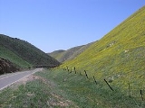
Temblor Range
Encyclopedia

San Joaquin Valley
The San Joaquin Valley is the area of the Central Valley of California that lies south of the Sacramento – San Joaquin River Delta in Stockton...
in California
California
California is a state located on the West Coast of the United States. It is by far the most populous U.S. state, and the third-largest by land area...
in the United States
United States
The United States of America is a federal constitutional republic comprising fifty states and a federal district...
. It runs in a northwest-southeasterly direction along the borders of Kern County and San Luis Obispo County. The name of the range is from the Spanish word for "earthquake". The San Andreas Fault Zone runs parallel to the range at the base of its western slope, on the eastern side of the Carrizo Plain
Carrizo Plain
The Carrizo Plain is a large enclosed plain, approximately 50 miles long and up to 15 miles across, in southeastern San Luis Obispo County, California, about 100 miles northwest of Los Angeles, California...
, while the Antelope Plain, location of the enormous Midway Sunset
Midway-Sunset Oil Field
The Midway-Sunset Oil Field is a large oil field in Kern County, San Joaquin Valley, California in the United States. Discovered in 1894, and having a cumulative production of close to of oil at the end of 2006, it is the largest oil field in California and the third largest in the United States....
, South Belridge
South Belridge Oil Field
The South Belridge Oil Field is a large oil field in northwestern Kern County, San Joaquin Valley, California, about forty miles west of Bakersfield...
, and Cymric
Cymric Oil Field
The Cymric Oil Field is a large oil field in Kern County, California in the United States. While only the 14th-largest oil field in California in total size, in terms of total remaining reserves it ranks fifth, with the equivalent of over still in the ground...
oil field
Oil field
An oil field is a region with an abundance of oil wells extracting petroleum from below ground. Because the oil reservoirs typically extend over a large area, possibly several hundred kilometres across, full exploitation entails multiple wells scattered across the area...
s, lies to the northeast.
Peaks within the Temblor Range average about 3500 ft (1,100 m) above sea level. The highest point is McKittrick Summit at 4,331 ft (1,320 m), located in the center of the range about 35 mi (56 km) west of Bakersfield. The summit on State Route 58
California State Route 58
State Route 58 is an east-west highway across the California Coast Ranges, the southern San Joaquin Valley, the Tehachapi Mountains, which border the southern Sierra Nevada, and the Mojave Desert. It runs between its western terminus near Santa Margarita and its eastern terminus at Barstow...
, which crosses the range, is at 3750 feet (1,143 m) above sea level.
Origin and composition
The Temblor Range and surrounding region contains extensive outcrops of the Monterey FormationMonterey Formation
The Monterey Formation is an extensive Miocene oil-rich geological sedimentary formation in California, with massive outcroppings of the formation in areas of the California Coast Ranges, Peninsular Ranges, and on some of California's off-shore islands...
(Miocene
Miocene
The Miocene is a geological epoch of the Neogene Period and extends from about . The Miocene was named by Sir Charles Lyell. Its name comes from the Greek words and and means "less recent" because it has 18% fewer modern sea invertebrates than the Pliocene. The Miocene follows the Oligocene...
age, about 20 to 9 million years). Rocks from the Monterey formation consist mostly of silicate
Silicate
A silicate is a compound containing a silicon bearing anion. The great majority of silicates are oxides, but hexafluorosilicate and other anions are also included. This article focuses mainly on the Si-O anions. Silicates comprise the majority of the earth's crust, as well as the other...
shale
Shale
Shale is a fine-grained, clastic sedimentary rock composed of mud that is a mix of flakes of clay minerals and tiny fragments of other minerals, especially quartz and calcite. The ratio of clay to other minerals is variable. Shale is characterized by breaks along thin laminae or parallel layering...
s and porcellanite
Porcellanite
Porcellanite or porcelanite, is a hard, dense rock somewhat similar in appearance to unglazed porcelain. It is often an impure variety of chert containing clay and calcareous matter....
(silica derived from fossil
Fossil
Fossils are the preserved remains or traces of animals , plants, and other organisms from the remote past...
plankton
Plankton
Plankton are any drifting organisms that inhabit the pelagic zone of oceans, seas, or bodies of fresh water. That is, plankton are defined by their ecological niche rather than phylogenetic or taxonomic classification...
in an intermediate to deep-water marine setting). Fossils and sediments from the Monterey Formation show that the Carrizo Plain region was a marine basin with shallow to intermediate depths (marine waters covered the southern San Joaquin Valley
San Joaquin Valley
The San Joaquin Valley is the area of the Central Valley of California that lies south of the Sacramento – San Joaquin River Delta in Stockton...
region). Marine sediments younger than about 9 million years are not preserved in the Carrizo Plain National Monument area, but they occur throughout the Kettleman Hills
Kettleman Hills
The Kettleman Hills is a low mountain range of the interior California Coast Ranges, in western Kings County, California. It is a northwest-southeast trending line of hills about 30 miles long which parallels the San Andreas Fault to the west....
region (about 60 miles (96.6 km) north of the park). The Pliocene
Pliocene
The Pliocene Epoch is the period in the geologic timescale that extends from 5.332 million to 2.588 million years before present. It is the second and youngest epoch of the Neogene Period in the Cenozoic Era. The Pliocene follows the Miocene Epoch and is followed by the Pleistocene Epoch...
-age Etchegoin Formation contains marine fossils to about 4 million years old. Fossils of the Etchegoin Formation are supporting evidence that the Coast Ranges and the Temblor Range are young, having been uplifted mostly during the Pleistocene
Pleistocene
The Pleistocene is the epoch from 2,588,000 to 11,700 years BP that spans the world's recent period of repeated glaciations. The name pleistocene is derived from the Greek and ....
Epoch (or Quaternary Period) in the past several million years. Much of that ongoing uplift is due to tectonics
Tectonics
Tectonics is a field of study within geology concerned generally with the structures within the lithosphere of the Earth and particularly with the forces and movements that have operated in a region to create these structures.Tectonics is concerned with the orogenies and tectonic development of...
associated with the San Andreas Fault and other fault systems in the region.
During the Pleistocene, sometime more recently than 1.8 million years ago, an enormous block of the Temblor Range – a swath of Monterey shale more than six miles (10 km) long, a mile across, and over 2000 feet (609.6 m) thick, about three cubic miles of rock in all – slid down the northeastern side of the range, covering a distance of approximately three miles and descending 2000 feet (609.6 m). This mass movement completely covered the McKittrick Oil Field
McKittrick Oil Field
The McKittrick Oil Field is a large oil and gas field in western Kern County, California. The town of McKittrick overlies the northeastern portion of the oil field...
, giving it a highly unusual geology for an oil field, as the petroleum deposits in most oil fields are in structural or stratigraphic traps; this field is capped by an enormous mass of rock that moved off of the adjacent mountain range.
External links
- Carrizo Plain National Monument - A 3D Photographic Tour Featuring Park Geology