
Escarpment
Encyclopedia
Description and variants
Usually escarpment is used interchangeably with scarp (from the ItalianItalian language
Italian is a Romance language spoken mainly in Europe: Italy, Switzerland, San Marino, Vatican City, by minorities in Malta, Monaco, Croatia, Slovenia, France, Libya, Eritrea, and Somalia, and by immigrant communities in the Americas and Australia...
scarpa, shoe). But some sources differentiate the two terms, where escarpment refers to the margin between two landforms, while scarp is synonymous with a cliff or steep slope. The surface of the steep slope is called a scarp face. Scarps are generally formed by one of two processes: either by differential erosion
Erosion
Erosion is when materials are removed from the surface and changed into something else. It only works by hydraulic actions and transport of solids in the natural environment, and leads to the deposition of these materials elsewhere...
of sedimentary rock
Sedimentary rock
Sedimentary rock are types of rock that are formed by the deposition of material at the Earth's surface and within bodies of water. Sedimentation is the collective name for processes that cause mineral and/or organic particles to settle and accumulate or minerals to precipitate from a solution....
s, or by vertical movement of the Earth's crust along a fault (faulting
Geologic fault
In geology, a fault is a planar fracture or discontinuity in a volume of rock, across which there has been significant displacement along the fractures as a result of earth movement. Large faults within the Earth's crust result from the action of tectonic forces...
).
Sedimentary rock
Sedimentary rock are types of rock that are formed by the deposition of material at the Earth's surface and within bodies of water. Sedimentation is the collective name for processes that cause mineral and/or organic particles to settle and accumulate or minerals to precipitate from a solution....
s to another series of a different age and composition. When sedimentary beds are tilted and exposed to the surface, erosion
Erosion
Erosion is when materials are removed from the surface and changed into something else. It only works by hydraulic actions and transport of solids in the natural environment, and leads to the deposition of these materials elsewhere...
and weathering
Weathering
Weathering is the breaking down of rocks, soils and minerals as well as artificial materials through contact with the Earth's atmosphere, biota and waters...
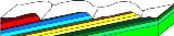
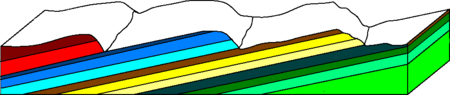
may occur differentially based on the composition. Less resistant rocks will erode faster, retreating until the point they are overlain by more resistant rock (see cross section schematic). When the dip
Strike and dip
Strike and dip refer to the orientation or attitude of a geologic feature. The strike line of a bed, fault, or other planar feature is a line representing the intersection of that feature with a horizontal plane. On a geologic map, this is represented with a short straight line segment oriented...
of the bedding is gentle, a cuesta
Cuesta
In structural geology and geomorphology, a cuesta is a ridge formed by gently tilted sedimentary rock strata in a homoclinal structure. Cuestas have a steep slope, where the rock layers are exposed on their edges, called an escarpment or, if more steep, a cliff...
is formed. Steeper dips (greater than 30-40°) form hogbacks
Hogback (geology)
A hogback is a homoclinal ridge, formed from a monocline, composed of steeply tilted strata of rock protruding from the surrounding area. The name comes from the ridge resembling the high, knobby spine between the shoulders of a hog. In most cases, the two strata that compose a hogback are...
.
Escarpments are also frequently formed by faults
Geologic fault
In geology, a fault is a planar fracture or discontinuity in a volume of rock, across which there has been significant displacement along the fractures as a result of earth movement. Large faults within the Earth's crust result from the action of tectonic forces...
. When a fault displaces the ground surface so that one side is higher than the other, a fault scarp
Fault scarp
A fault scarp is the topographic expression of faulting attributed to the displacement of the land surface by movement along faults. They are exhibited either by differential movement and subsequent erosion along an old inactive geologic fault , or by a movement on a recent active fault...
is created. This can occur in dip-slip faults, or when a strike-slip fault brings a piece of high ground adjacent to an area of lower ground.
More loosely, the term scarp describes the zone between coastal lowlands and continental plateau
Plateau
In geology and earth science, a plateau , also called a high plain or tableland, is an area of highland, usually consisting of relatively flat terrain. A highly eroded plateau is called a dissected plateau...
s which have a marked, abrupt change in elevation caused by coastal erosion at the base of the plateau.
Earth is not the only planet where escarpments occur. They are believed to occur on other planets when the crust
Crust (geology)
In geology, the crust is the outermost solid shell of a rocky planet or natural satellite, which is chemically distinct from the underlying mantle...
contracts, as a result of cooling. On other Solar System
Solar System
The Solar System consists of the Sun and the astronomical objects gravitationally bound in orbit around it, all of which formed from the collapse of a giant molecular cloud approximately 4.6 billion years ago. The vast majority of the system's mass is in the Sun...
bodies such as Mercury
Mercury (planet)
Mercury is the innermost and smallest planet in the Solar System, orbiting the Sun once every 87.969 Earth days. The orbit of Mercury has the highest eccentricity of all the Solar System planets, and it has the smallest axial tilt. It completes three rotations about its axis for every two orbits...
, Mars
Mars
Mars is the fourth planet from the Sun in the Solar System. The planet is named after the Roman god of war, Mars. It is often described as the "Red Planet", as the iron oxide prevalent on its surface gives it a reddish appearance...
, and the Moon
Moon
The Moon is Earth's only known natural satellite,There are a number of near-Earth asteroids including 3753 Cruithne that are co-orbital with Earth: their orbits bring them close to Earth for periods of time but then alter in the long term . These are quasi-satellites and not true moons. For more...
, the Latin term rupes
Rupes
Rupes is the Latin word for 'cliff'. It is used in planetary geology to refer to escarpments on other planets, such as Mercury, and moons, such as Luna, Earth's natural satellite.How rupes are formed is, as of 2008, a matter of speculation...
is used for an escarpment.
.jpg)
Africa
- Elgeyo escarpmentElgeyo escarpmentElgeyo escarpment is a fault-scarp caused by post-Miocene faulting and there are Miocene beds visible. The escarpment is part of the western wall of the Great Rift Valley....
(Great Rift ValleyGreat Rift ValleyThe Great Rift Valley is a name given in the late 19th century by British explorer John Walter Gregory to the continuous geographic trench, approximately in length, that runs from northern Syria in Southwest Asia to central Mozambique in South East Africa...
) - God's Window (South AfricaSouth AfricaThe Republic of South Africa is a country in southern Africa. Located at the southern tip of Africa, it is divided into nine provinces, with of coastline on the Atlantic and Indian oceans...
) - Great EscarpmentGreat EscarpmentThe Great Escarpment is a mountainous escarpment in southern Africa. While it lies predominantly within the borders of Lesotho and South Africa, it also extends into Angola, Namibia, Swaziland, Mozambique, and Zimbabwe....
(South Africa) - Bandiagara EscarpmentBandiagara EscarpmentThe Bandiagara Escarpment is an escarpment in the Dogon country of Mali. The sandstone cliff rises about 500 meters above the lower sandy flats to the south. It has a length of approximately 150 kilometers. The area of the escarpment is inhabited today by the Dogon people. Before the Dogon, the...
(MaliMaliMali , officially the Republic of Mali , is a landlocked country in Western Africa. Mali borders Algeria on the north, Niger on the east, Burkina Faso and the Côte d'Ivoire on the south, Guinea on the south-west, and Senegal and Mauritania on the west. Its size is just over 1,240,000 km² with...
) - Zambezi EscarpmentZambezi EscarpmentZambezi Escarpment is a name used for the escarpments forming both sides of the rift valley or graben in which lie the middle Zambezi river and Lake Kariba...
(ZambiaZambiaZambia , officially the Republic of Zambia, is a landlocked country in Southern Africa. The neighbouring countries are the Democratic Republic of the Congo to the north, Tanzania to the north-east, Malawi to the east, Mozambique, Zimbabwe, Botswana and Namibia to the south, and Angola to the west....
) - Scarp of Angola (AngolaAngolaAngola, officially the Republic of Angola , is a country in south-central Africa bordered by Namibia on the south, the Democratic Republic of the Congo on the north, and Zambia on the east; its west coast is on the Atlantic Ocean with Luanda as its capital city...
)
Australia and New Zealand
- AustraliaAustraliaAustralia , officially the Commonwealth of Australia, is a country in the Southern Hemisphere comprising the mainland of the Australian continent, the island of Tasmania, and numerous smaller islands in the Indian and Pacific Oceans. It is the world's sixth-largest country by total area...
- Darling ScarpDarling ScarpThe Darling Scarp, also referred to as the Darling Range or Darling Ranges, is a low escarpment running north-south to the east of the Swan Coastal Plain and Perth, Western Australia...
- Dorrigo PlateauDorrigo PlateauDorrigo Plateau is a plateau in northern New South Wales, which forms part of the Great Dividing Range. The plateau is sometimes referred to as the Dorrigo & Guy Fawkes Plateau....
- Illawarra EscarpmentIllawarra escarpmentThe Illawarra Escarpment is the fold created cliffs and plateau eroded outcrop mountain range west of the Illawarra coastal plain south of Sydney, Australia, enclosing the region known as the Illawarra which stretches from Stanwell Park in the north to Kiama, Gerringong and the Shoalhaven river in...
- Nullarbor Escarpment
- Darling Scarp
- New ZealandNew ZealandNew Zealand is an island country in the south-western Pacific Ocean comprising two main landmasses and numerous smaller islands. The country is situated some east of Australia across the Tasman Sea, and roughly south of the Pacific island nations of New Caledonia, Fiji, and Tonga...
- The western slope of the Southern AlpsSouthern AlpsThe Southern Alps is a mountain range extending along much of the length of New Zealand's South Island, reaching its greatest elevations near the island's western side...
(along the Alpine FaultAlpine FaultThe Alpine Fault is a geological fault, more specifically known as a right-lateral strike-slip fault, that runs almost the entire length of New Zealand's South Island. It forms a transform boundary between the Pacific Plate and the Indo-Australian Plate. Earthquakes along the fault, and the...
) - The KaimaiKaimai RangesThe Kaimai Range is a mountain range in the North Island of New Zealand. It is part of a series of ranges, with the Coromandel Range to the north and the Mamaku Ranges to the south. The Kaimai Range separates the Waikato in the west from the Bay of Plenty in the east.The highest point of the range...
escarpment, above the Hauraki PlainsHauraki PlainsThe Hauraki Plains are a geographical feature and non-administrative area located in the northern North Island of New Zealand, at the lower end of the Thames Valley...
- The western slope of the Southern Alps
Europe
- England
- Cotswold escarpmentCotswoldsThe Cotswolds are a range of hills in west-central England, sometimes called the Heart of England, an area across and long. The area has been designated as the Cotswold Area of Outstanding Natural Beauty...
- North DownsNorth DownsThe North Downs are a ridge of chalk hills in south east England that stretch from Farnham in Surrey to the White Cliffs of Dover in Kent. The North Downs lie within two Areas of Outstanding Natural Beauty , the Surrey Hills and the Kent Downs...
- South DownsSouth DownsThe South Downs is a range of chalk hills that extends for about across the south-eastern coastal counties of England from the Itchen Valley of Hampshire in the west to Beachy Head, near Eastbourne, East Sussex, in the east. It is bounded on its northern side by a steep escarpment, from whose...
- A colloquial adjective to describe escarpments in England is "edge" as in
- Alderley EdgeAlderley EdgeAlderley Edge is a village and civil parish within the unitary authority of Cheshire East and the ceremonial county of Cheshire, England. According to the 2001 census the parish had a population of 4,409....
- Edge HillEdge Hill, WarwickshireEdge Hill is an escarpment and hamlet in the civil parish of Ratley and Upton, South Warwickshire, England.Edge Hill gave its name to the first battle of the English Civil War, in which it was a prominent feature....
famous as the place of the first battle of the English Civil WarEnglish Civil WarThe English Civil War was a series of armed conflicts and political machinations between Parliamentarians and Royalists...
. - Kinver EdgeKinver EdgeKinver Edge is a high heath and woodland escarpment just west of Kinver, about four miles west of Stourbridge, and four miles north of Kidderminster, and is on the border between Worcestershire and Staffordshire, England. It is now owned by the National Trust....
- The Lincoln EdgeLincoln CliffThe Lincoln Cliff is the portion of a major escarpment that runs north-south through Lindsey and Kesteven, in central Lincolnshire and is a prominent landscape feature in a generally flat portion of the county...
- Wenlock EdgeWenlock EdgeWenlock Edge is a limestone escarpment near Much Wenlock, Shropshire, England. It is long and runs from South West to North East between Craven Arms and Much Wenlock. It is roughly 330 metres high...
- Alderley Edge
- Cotswold escarpment
- FranceFranceThe French Republic , The French Republic , The French Republic , (commonly known as France , is a unitary semi-presidential republic in Western Europe with several overseas territories and islands located on other continents and in the Indian, Pacific, and Atlantic oceans. Metropolitan France...
- La Côte d'OrCôte d'Or (escarpment)The Côte d'Or is a limestone escarpment in Burgundy, France that lends its name to the department which was formed around it...
is famous for its wineWineWine is an alcoholic beverage, made of fermented fruit juice, usually from grapes. The natural chemical balance of grapes lets them ferment without the addition of sugars, acids, enzymes, or other nutrients. Grape wine is produced by fermenting crushed grapes using various types of yeast. Yeast...
s and has given its name to a département, Côte-d'OrCôte-d'OrCôte-d'Or is a department in the eastern part of France.- History :Côte-d'Or is one of the original 83 departments created during the French Revolution on 4 March 1790. It was formed from part of the former province of Burgundy.- Geography :...
. - Le Pays de BrayPays de BrayThe Pays de Bray is a small natural region of France situated to the north-east of Rouen, straddling the French départements of the Seine-Maritime and Oise...
, a clayClayClay is a general term including many combinations of one or more clay minerals with traces of metal oxides and organic matter. Geologic clay deposits are mostly composed of phyllosilicate minerals containing variable amounts of water trapped in the mineral structure.- Formation :Clay minerals...
vale enclosed by chalkChalkChalk is a soft, white, porous sedimentary rock, a form of limestone composed of the mineral calcite. Calcite is calcium carbonate or CaCO3. It forms under reasonably deep marine conditions from the gradual accumulation of minute calcite plates shed from micro-organisms called coccolithophores....
escarpments.
- La Côte d'Or
- Sweden, Estonia and Russia
- Baltic KlintBaltic KlintThe Baltic Klint is an erosional limestone escarpment on several islands of the Baltic Sea, in Estonia and in Leningrad Oblast of Russia...
- Gotland–Saaremaa Klint
- Baltic Klint
- Malta
- Victoria Lines
North America
- Canada and the United States
- Pembina EscarpmentPembina EscarpmentThe Manitoba Escarpment is a scarp that marks the boundary of glacial Lake Agassiz. It occurs in South Dakota, North Dakota, and Manitoba....
(ManitobaManitobaManitoba is a Canadian prairie province with an area of . The province has over 110,000 lakes and has a largely continental climate because of its flat topography. Agriculture, mostly concentrated in the fertile southern and western parts of the province, is vital to the province's economy; other...
, North DakotaNorth DakotaNorth Dakota is a state located in the Midwestern region of the United States of America, along the Canadian border. The state is bordered by Canada to the north, Minnesota to the east, South Dakota to the south and Montana to the west. North Dakota is the 19th-largest state by area in the U.S....
) - Niagara EscarpmentNiagara EscarpmentThe Niagara Escarpment is a long escarpment, or cuesta, in the United States and Canada that runs westward from New York State, through Ontario, Michigan, Wisconsin and Illinois...
(OntarioOntarioOntario is a province of Canada, located in east-central Canada. It is Canada's most populous province and second largest in total area. It is home to the nation's most populous city, Toronto, and the nation's capital, Ottawa....
, IllinoisIllinoisIllinois is the fifth-most populous state of the United States of America, and is often noted for being a microcosm of the entire country. With Chicago in the northeast, small industrial cities and great agricultural productivity in central and northern Illinois, and natural resources like coal,...
, MichiganMichiganMichigan is a U.S. state located in the Great Lakes Region of the United States of America. The name Michigan is the French form of the Ojibwa word mishigamaa, meaning "large water" or "large lake"....
, New YorkNew YorkNew York is a state in the Northeastern region of the United States. It is the nation's third most populous state. New York is bordered by New Jersey and Pennsylvania to the south, and by Connecticut, Massachusetts and Vermont to the east...
, and WisconsinWisconsinWisconsin is a U.S. state located in the north-central United States and is part of the Midwest. It is bordered by Minnesota to the west, Iowa to the southwest, Illinois to the south, Lake Michigan to the east, Michigan to the northeast, and Lake Superior to the north. Wisconsin's capital is...
) - Onondaga (geological formation)Onondaga (geological formation)The Onondaga Formation is a group of hard limestones and dolostones of Devonian age that form an important geographic feature in some areas in which it outcrops, in others; especially its Southern Ontario portion, the formation can be less prominent as a local surface feature.In upstate New York...
(OntarioOntarioOntario is a province of Canada, located in east-central Canada. It is Canada's most populous province and second largest in total area. It is home to the nation's most populous city, Toronto, and the nation's capital, Ottawa....
and New YorkNew YorkNew York is a state in the Northeastern region of the United States. It is the nation's third most populous state. New York is bordered by New Jersey and Pennsylvania to the south, and by Connecticut, Massachusetts and Vermont to the east...
) - Devil's RockDevil's RockDevil's Rock or Devils Rock is a granite escarpment, located south of Haileybury, Ontario, Canada. It is dated to be 2,200 million years old and it has a face of rising above Lake Timiskaming. People have been rock climbing Devil's Rock in recent years. There are five tunnels in the cliffs face...
(Lake Temiskaming, OntarioOntarioOntario is a province of Canada, located in east-central Canada. It is Canada's most populous province and second largest in total area. It is home to the nation's most populous city, Toronto, and the nation's capital, Ottawa....
)
- Pembina Escarpment
- United States
- Devil's Slide (Northern CaliforniaNorthern CaliforniaNorthern California is the northern portion of the U.S. state of California. The San Francisco Bay Area , and Sacramento as well as its metropolitan area are the main population centers...
) - Allegheny FrontAllegheny FrontThe Allegheny Front is the major southeast- or east-facing escarpment in the Allegheny Mountains in southern Pennsylvania, western Maryland, and eastern West Virginia, USA. The Allegheny Front delineates the Ridge-and-Valley Appalachians to its east from the Appalachian Plateau to its west...
(PennsylvaniaPennsylvaniaThe Commonwealth of Pennsylvania is a U.S. state that is located in the Northeastern and Mid-Atlantic regions of the United States. The state borders Delaware and Maryland to the south, West Virginia to the southwest, Ohio to the west, New York and Ontario, Canada, to the north, and New Jersey to...
-MarylandMarylandMaryland is a U.S. state located in the Mid Atlantic region of the United States, bordering Virginia, West Virginia, and the District of Columbia to its south and west; Pennsylvania to its north; and Delaware to its east...
-West VirginiaWest VirginiaWest Virginia is a state in the Appalachian and Southeastern regions of the United States, bordered by Virginia to the southeast, Kentucky to the southwest, Ohio to the northwest, Pennsylvania to the northeast and Maryland to the east...
) - Balcones FaultBalcones FaultThe Balcones Fault Zone is a tensional structural system in Texas that runs approximately from the southwest part of the state near Del Rio to the north central region near Waco along Interstate 35. The Balcones Fault zone is made up of many smaller features, including normal faults, grabens, and...
(TexasTexasTexas is the second largest U.S. state by both area and population, and the largest state by area in the contiguous United States.The name, based on the Caddo word "Tejas" meaning "friends" or "allies", was applied by the Spanish to the Caddo themselves and to the region of their settlement in...
) - Bergen HillBergen HillBergen Hill refers to the lower Hudson Palisades in New Jersey, USA, where they emerge on Bergen Neck, which in turn is the peninsula between the Hackensack and Hudson River, and their bays. In Hudson County, it reaches a height of 260 feet.-Rail:...
(New Jersey) - Blue Ridge Escarpment (South CarolinaSouth CarolinaSouth Carolina is a state in the Deep South of the United States that borders Georgia to the south, North Carolina to the north, and the Atlantic Ocean to the east. Originally part of the Province of Carolina, the Province of South Carolina was one of the 13 colonies that declared independence...
-GeorgiaGeorgia (U.S. state)Georgia is a state located in the southeastern United States. It was established in 1732, the last of the original Thirteen Colonies. The state is named after King George II of Great Britain. Georgia was the fourth state to ratify the United States Constitution, on January 2, 1788...
) - Book CliffsBook CliffsThe Book Cliffs are a series of mountains and cliffs in western Colorado and eastern Utah, in the western United States. They are so named because many of them have the triangular appearance of a book that has been opened up, then turned on its sides and set to rest on the open sides of the book,...
(UtahUtahUtah is a state in the Western United States. It was the 45th state to join the Union, on January 4, 1896. Approximately 80% of Utah's 2,763,885 people live along the Wasatch Front, centering on Salt Lake City. This leaves vast expanses of the state nearly uninhabited, making the population the...
-ColoradoColoradoColorado is a U.S. state that encompasses much of the Rocky Mountains as well as the northeastern portion of the Colorado Plateau and the western edge of the Great Plains...
) - Caprock EscarpmentCaprock EscarpmentThe Caprock Escarpment is a term used in Texas and Eastern New Mexico to describe the geographical transition point between the level elevated plains of the Llano Estacado and the surrounding rolling terrain. In Texas, the escarpment stretches around 320 km south-southwest from the northeast...
(TexasTexasTexas is the second largest U.S. state by both area and population, and the largest state by area in the contiguous United States.The name, based on the Caddo word "Tejas" meaning "friends" or "allies", was applied by the Spanish to the Caddo themselves and to the region of their settlement in...
) - Catskill EscarpmentCatskill MountainsThe Catskill Mountains, an area in New York State northwest of New York City and southwest of Albany, are a mature dissected plateau, an uplifted region that was subsequently eroded into sharp relief. They are an eastward continuation, and the highest representation, of the Allegheny Plateau...
(New YorkNew YorkNew York is a state in the Northeastern region of the United States. It is the nation's third most populous state. New York is bordered by New Jersey and Pennsylvania to the south, and by Connecticut, Massachusetts and Vermont to the east...
) - Cody ScarpCody ScarpThe Cody Scarp or escarpment is located in north and north central Florida USA. It is a relict scarp and ancient persistent topographical feature formed from an ancient early Pleistocene shorelines of ~1.8 million to 10,000 years BP during interglacial periods...
(FloridaFloridaFlorida is a state in the southeastern United States, located on the nation's Atlantic and Gulf coasts. It is bordered to the west by the Gulf of Mexico, to the north by Alabama and Georgia and to the east by the Atlantic Ocean. With a population of 18,801,310 as measured by the 2010 census, it...
) - Elkhorn Scarp (San Andreas FaultSan Andreas FaultThe San Andreas Fault is a continental strike-slip fault that runs a length of roughly through California in the United States. The fault's motion is right-lateral strike-slip...
) - Highland RimHighland RimThe Highland Rim is a geographic term for the area in Tennessee surrounding the Central Basin. Nashville is largely surrounded by higher terrain in all directions....
encircling the Nashville BasinNashville BasinThe Nashville Basin, also known as the Central Basin, is a term often used to describe the area surrounding Nashville, Tennessee. The Central Basin was caused by an uplifting known as the Nashville Dome. The Nashville Dome is evidenced by the underlying rock strata that all dip downwards away from...
(actually a geologic dome) in Middle TennesseeMiddle TennesseeMiddle Tennessee is a distinct portion of the state of Tennessee, delineated according to state law as the 41 counties in the Middle Grand Division of Tennessee.... - Knobstone EscarpmentKnobstone EscarpmentThe Knobstone Escarpment is a rugged geologic region in Southern Indiana. Physically, the Knobstone Escarpment is the most rugged terrain in Indiana. The highest hill in the area is Weed Patch Hill, with an elevation of 1,056 feet above sea level....
(Southern IndianaSouthern IndianaSouthern Indiana, in the United States, consists of the 33 counties located in the southernmost part of the state. The region's history and geography has led to a blend of Northern and Southern culture distinct from the remainder of Indiana. It is often considered to be part of the Upland South...
) - Mescalero EscarpmentMescalero EscarpmentThe Mescalero Escarpment, also known as the Mescalero Ridge, forms the western edge of the great Llano Estacado, a vast plateau or tableland in the southwestern United States in New Mexico and Texas...
(New MexicoNew MexicoNew Mexico is a state located in the southwest and western regions of the United States. New Mexico is also usually considered one of the Mountain States. With a population density of 16 per square mile, New Mexico is the sixth-most sparsely inhabited U.S...
) - Missouri EscarpmentMissouri EscarpmentThe Missouri Escarpment is a ridge in North Dakota approximately 100 miles to the west of the Red River Valley, at the edge of the Missouri Plateau. It divides the Central Lowlands province from the Great Plains province.-External links:*...
(North DakotaNorth DakotaNorth Dakota is a state located in the Midwestern region of the United States of America, along the Canadian border. The state is bordered by Canada to the north, Minnesota to the east, South Dakota to the south and Montana to the west. North Dakota is the 19th-largest state by area in the U.S....
) - Mogollon RimMogollon RimThe Mogollon Rim is a topographical and geological feature running across the U.S. state of Arizona. It extends approximately from northern Yavapai County eastward to near the border with New Mexico.-Description:...
(ArizonaArizonaArizona ; is a state located in the southwestern region of the United States. It is also part of the western United States and the mountain west. The capital and largest city is Phoenix...
) - Muldraugh HillMuldraugh HillMuldraugh Hill is an escarpment in central Kentucky separating the Bluegrass on the north and north-east from the Pennyrile on the south and south-west...
(KentuckyKentuckyThe Commonwealth of Kentucky is a state located in the East Central United States of America. As classified by the United States Census Bureau, Kentucky is a Southern state, more specifically in the East South Central region. Kentucky is one of four U.S. states constituted as a commonwealth...
) - Pine RidgePine Ridge (region)The Pine Ridge is an escarpment between the Niobrara River and the White River in far northwestern Nebraska...
(NebraskaNebraskaNebraska is a state on the Great Plains of the Midwestern United States. The state's capital is Lincoln and its largest city is Omaha, on the Missouri River....
and South DakotaSouth DakotaSouth Dakota is a state located in the Midwestern region of the United States. It is named after the Lakota and Dakota Sioux American Indian tribes. Once a part of Dakota Territory, South Dakota became a state on November 2, 1889. The state has an area of and an estimated population of just over...
) - Pottsville EscarpmentPottsville EscarpmentThe Pottsville Escarpment is a resistant sandstone belt of cliffs and steep sided, narrow crested valleys in eastern Kentucky, USA. It features rock shelters, waterfalls, and natural bridges...
(KentuckyKentuckyThe Commonwealth of Kentucky is a state located in the East Central United States of America. As classified by the United States Census Bureau, Kentucky is a Southern state, more specifically in the East South Central region. Kentucky is one of four U.S. states constituted as a commonwealth...
-TennesseeTennesseeTennessee is a U.S. state located in the Southeastern United States. It has a population of 6,346,105, making it the nation's 17th-largest state by population, and covers , making it the 36th-largest by total land area...
; see Cumberland PlateauCumberland PlateauThe Cumberland Plateau is the southern part of the Appalachian Plateau. It includes much of eastern Kentucky and western West Virginia, part of Tennessee, and a small portion of northern Alabama and northwest Georgia . The terms "Allegheny Plateau" and the "Cumberland Plateau" both refer to the...
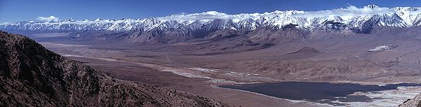
) - Sierra Nevada range (eastern slope) in CaliforniaCaliforniaCalifornia is a state located on the West Coast of the United States. It is by far the most populous U.S. state, and the third-largest by land area...
- Sigsbee Escarpment, Gulf of MexicoGulf of MexicoThe Gulf of Mexico is a partially landlocked ocean basin largely surrounded by the North American continent and the island of Cuba. It is bounded on the northeast, north and northwest by the Gulf Coast of the United States, on the southwest and south by Mexico, and on the southeast by Cuba. In...
- Portage Escarpment (OhioOhioOhio is a Midwestern state in the United States. The 34th largest state by area in the U.S.,it is the 7th‑most populous with over 11.5 million residents, containing several major American cities and seven metropolitan areas with populations of 500,000 or more.The state's capital is Columbus...
) - Potrero HillsPotrero Hills (Richmond, California)The Potrero Hills also known as the Potrero Ridge and Point Molate Hills is a chaparral and forested escarpment of that crests northwest to southeast along the San Pablo Peninsula in Richmond, California.-History:...
in Richmond, CaliforniaRichmond, CaliforniaRichmond is a city in western Contra Costa County, California, United States. The city was incorporated on August 7, 1905. It is located in the East Bay, part of the San Francisco Bay Area. It is a residential inner suburb of San Francisco, as well as the site of heavy industry, which has been...
- Devil's Slide (Northern California
- The Caribbean
- Bahamas Escarpment (Bahamas)