
Rift
Encyclopedia

Geology
Geology is the science comprising the study of solid Earth, the rocks of which it is composed, and the processes by which it evolves. Geology gives insight into the history of the Earth, as it provides the primary evidence for plate tectonics, the evolutionary history of life, and past climates...
, a rift or chasm is a place where the Earth's
Earth
Earth is the third planet from the Sun, and the densest and fifth-largest of the eight planets in the Solar System. It is also the largest of the Solar System's four terrestrial planets...
crust
Crust (geology)
In geology, the crust is the outermost solid shell of a rocky planet or natural satellite, which is chemically distinct from the underlying mantle...
and lithosphere
Lithosphere
The lithosphere is the rigid outermost shell of a rocky planet. On Earth, it comprises the crust and the portion of the upper mantle that behaves elastically on time scales of thousands of years or greater.- Earth's lithosphere :...
are being pulled apart and is an example of extensional tectonics
Extensional tectonics
Extensional tectonics is concerned with the structures formed, and the tectonic processes associated with, the stretching of the crust or lithosphere.-Deformation styles:...
.
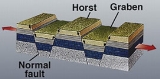
Typical rift features are a central linear downfaulted segment, called a graben
Graben
In geology, a graben is a depressed block of land bordered by parallel faults. Graben is German for ditch. Graben is used for both the singular and plural....
, with parallel normal faulting and rift-flank uplifts on either side forming a rift valley
Rift valley
A rift valley is a linear-shaped lowland between highlands or mountain ranges created by the action of a geologic rift or fault. This action is manifest as crustal extension, a spreading apart of the surface which is subsequently further deepened by the forces of erosion...
, where the rift remains above sea level. The axis of the rift area commonly contains volcanic rocks, and active volcanism
Volcanism
Volcanism is the phenomenon connected with volcanoes and volcanic activity. It includes all phenomena resulting from and causing magma within the crust or mantle of a planet to rise through the crust and form volcanic rocks on the surface....
is a part of many, but not all active rift systems.
Major rifts occur along the central axis of mid-ocean ridge
Mid-ocean ridge
A mid-ocean ridge is a general term for an underwater mountain system that consists of various mountain ranges , typically having a valley known as a rift running along its spine, formed by plate tectonics. This type of oceanic ridge is characteristic of what is known as an oceanic spreading...
s, where new oceanic crust
Oceanic crust
Oceanic crust is the part of Earth's lithosphere that surfaces in the ocean basins. Oceanic crust is primarily composed of mafic rocks, or sima, which is rich in iron and magnesium...
and lithosphere is created along a divergent boundary
Divergent boundary
In plate tectonics, a divergent boundary or divergent plate boundary is a linear feature that exists between two tectonic plates that are moving away from each other. Divergent boundaries within continents initially produce rifts which produce rift valleys...
between two tectonic plates.
Failed rifts are where continental rifting began, but then failed to continue to the point of break-up. Typically the transition from rifting to spreading develops at a triple junction
Triple junction
A triple junction is the point where the boundaries of three tectonic plates meet. At the triple junction a boundary will be one of 3 types - a ridge, trench or transform fault - and triple junctions can be described according to the types of plate margin that meet at them...
where three converging rifts meet over a hotspot
Hotspot (geology)
The places known as hotspots or hot spots in geology are volcanic regions thought to be fed by underlying mantle that is anomalously hot compared with the mantle elsewhere. They may be on, near to, or far from tectonic plate boundaries. There are two hypotheses to explain them...
. Two of these evolve to the point of seafloor spreading, while the third ultimately fails, becoming an aulacogen
Aulacogen
In geology, an aulacogen is a failed arm of a triple junction of a plate tectonics rift system. A triple junction beneath a continental plate initiates a three way breakup of the continental plate. As the continental break-up develops one of the three spreading ridges typically fails or stops...
.
Examples
- The East African RiftEast African RiftThe East African Rift is an active continental rift zone in eastern Africa that appears to be a developing divergent tectonic plate boundary. It is part of the larger Great Rift Valley. The rift is a narrow zone in which the African Plate is in the process of splitting into two new tectonic plates...
- The Red Sea RiftRed Sea RiftThe Red Sea Rift is a spreading center between two tectonic plates, the African Plate and the Arabian Plate. It extends down the length of the Red Sea, stretching from the southern end of the Dead Sea Transform to a triple junction with the Aden Ridge and the East African Rift in the Afar...
- The Baikal Rift ZoneBaikal Rift ZoneThe Baikal Rift Zone is a divergent plate boundary centered beneath Lake Baikal in southeastern Russia. To its west is the Eurasian Plate and to its east is the Amur Plate which is moving away from the rift toward Japan at about 4 mm per year....
, the bottom of Lake BaikalLake BaikalLake Baikal is the world's oldest at 30 million years old and deepest lake with an average depth of 744.4 metres.Located in the south of the Russian region of Siberia, between Irkutsk Oblast to the northwest and the Buryat Republic to the southeast, it is the most voluminous freshwater lake in the...
is the deepest continental rift on the earth. - The Gulf of Suez RiftGulf of Suez RiftThe Gulf of Suez Rift is a continental rift zone that was active between the Late Oligocene and the end of the Miocene . It represented a continuation of the Red Sea Rift until break-up occurred in the middle Miocene, with most of the displacement on the newly developed Red Sea spreading centre...
- Lake TimiskamingLake TimiskamingLake Timiskaming is a large freshwater lake on the provincial border between Ontario and Quebec, Canada. The lake, which forms part of the Ottawa River, is in length and covers an area of almost . Its water level ranges between and above sea-level, with a mean annual average of . The lake is...
in Temiskaming Shores, OntarioOntarioOntario is a province of Canada, located in east-central Canada. It is Canada's most populous province and second largest in total area. It is home to the nation's most populous city, Toronto, and the nation's capital, Ottawa.... - Throughout the Basin and Range Province in North AmericaNorth AmericaNorth America is a continent wholly within the Northern Hemisphere and almost wholly within the Western Hemisphere. It is also considered a northern subcontinent of the Americas...
- The Rio Grande RiftRio Grande RiftThe Rio Grande Rift is a north-trending continental rift zone. It separates the Colorado Plateau in the west from the interior of the North American craton on the east. The rift extends from central Colorado in the north to the state of Chihuahua, Mexico in the south. The rift zone consists of four...
in the southwestern US - The rift zone that contains the Gulf of CorinthGulf of CorinthThe Gulf of Corinth or the Corinthian Gulf is a deep inlet of the Ionian Sea separating the Peloponnese from western mainland Greece...
in GreeceGreeceGreece , officially the Hellenic Republic , and historically Hellas or the Republic of Greece in English, is a country in southeastern Europe.... - The Reelfoot Rift, an ancient buried failed rift underlying the New Madrid Seismic ZoneNew Madrid Seismic ZoneThe New Madrid Seismic Zone , sometimes called the New Madrid Fault Line, is a major seismic zone and a prolific source of intraplate earthquakes in the southern and midwestern United States, stretching to the southwest from New Madrid, Missouri.The New Madrid fault system was responsible for the...
in the Mississippi embaymentMississippi embaymentThe Mississippi Embayment is a physiographic feature in the south-central United States, part of the Mississippi Alluvial Plain. It is essentially a northward continuation of the fluvial sediments of the Mississippi River Delta to its confluence with the Ohio River at Cairo, Illinois. The embayment... - The Rhine Rift, in south western Germany, known as the Upper Rhine valley, part of the European Cenozoic Rift SystemEuropean Cenozoic Rift SystemThe European Cenozoic Rift System is an 1100 km long system of rifts formed in the foreland of the Alps as the lithosphere responded to the effects of the Alpine and Pyrenean orogenies...
- The Taupo Volcanic ZoneTaupo Volcanic ZoneThe Taupo Volcanic Zone is a highly active volcanic V shaped area in the North Island of New Zealand that is spreading east -west at the rate of about 8mm per year...
in the north east North IslandNorth IslandThe North Island is one of the two main islands of New Zealand, separated from the much less populous South Island by Cook Strait. The island is in area, making it the world's 14th-largest island...
of New ZealandNew ZealandNew Zealand is an island country in the south-western Pacific Ocean comprising two main landmasses and numerous smaller islands. The country is situated some east of Australia across the Tasman Sea, and roughly south of the Pacific island nations of New Caledonia, Fiji, and Tonga... - The Oslo GrabenOslo GrabenThe Oslo Graben or Oslo Rift is a graben formed during a geologic rifting event in Permian time, the last phase of the Variscan orogeny. The main graben forming period began in the late Carboniferous, which culminated with rift formation and volcanism, with associated rhomb porphyry lava flows...
in NorwayNorwayNorway , officially the Kingdom of Norway, is a Nordic unitary constitutional monarchy whose territory comprises the western portion of the Scandinavian Peninsula, Jan Mayen, and the Arctic archipelago of Svalbard and Bouvet Island. Norway has a total area of and a population of about 4.9 million... - The Ottawa-Bonnechere GrabenOttawa-Bonnechere GrabenThe Ottawa-Bonnechere Graben , with its branch the Timiskaming Graben, is an ancient rift valley in the Canadian Shield of Northeastern Ontario and Quebec, Canada. This rift valley was formed when the Earth's crust moved downward about a kilometre between two major fault zones known as the Mattawa...
in Ontario and Quebec - The Northern Cordilleran Volcanic ProvinceNorthern Cordilleran volcanic provinceThe Northern Cordilleran Volcanic Province , formerly known as the Stikine Volcanic Belt, is a geologic province defined by the occurrence of Miocene to Holocene volcanoes in the Pacific Northwest of North America...
in British ColumbiaBritish ColumbiaBritish Columbia is the westernmost of Canada's provinces and is known for its natural beauty, as reflected in its Latin motto, Splendor sine occasu . Its name was chosen by Queen Victoria in 1858...
, YukonYukonYukon is the westernmost and smallest of Canada's three federal territories. It was named after the Yukon River. The word Yukon means "Great River" in Gwich’in....
and AlaskaAlaskaAlaska is the largest state in the United States by area. It is situated in the northwest extremity of the North American continent, with Canada to the east, the Arctic Ocean to the north, and the Pacific Ocean to the west and south, with Russia further west across the Bering Strait... - The West Antarctic RiftWest Antarctic RiftThe West Antarctic Rift is a major, active rift valley lying between East and West Antarctica. It encompasses the Ross Sea, the area under the Ross Ice Shelf and a part of West Antarctica...
in Antarctica - The Midcontinent Rift SystemMidcontinent Rift SystemThe Midcontinent Rift System or Keweenawan Rift is a long geological rift in the center of the North American continent and south-central part of the North American plate. It formed when the continent's core, the North American craton, began to split apart during the Mesoproterozoic era of the...
, a late PrecambrianPrecambrianThe Precambrian is the name which describes the large span of time in Earth's history before the current Phanerozoic Eon, and is a Supereon divided into several eons of the geologic time scale...
rift in central North America - The Fundy BasinFundy BasinThe Fundy Basin is a sediment-filled rift basin on the Atlantic coast of southeastern Canada. It contains three sub-basins; the Fundy sub-basin, the Minas Basin and the Chignecto Basin. These arms meet at the Bay of Fundy, which is contained within the rift valley. From the Bay of Fundy, the Minas...
, a TriassicTriassicThe Triassic is a geologic period and system that extends from about 250 to 200 Mya . As the first period of the Mesozoic Era, the Triassic follows the Permian and is followed by the Jurassic. Both the start and end of the Triassic are marked by major extinction events...
rift basin in southeastern Canada - The Narmada Rift valley in peninsular India