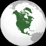
Encyclopedia
]
North America is a
continent in the
Earth's
northern hemisphere and almost fully in the
western hemisphere. It is bordered on the north by the
Arctic Ocean, on the east by the North
Atlantic Ocean, on the southeast by the
Caribbean Sea, and on the south and west by the North
Pacific Ocean;
South America lies to the southeast. It covers an
area of about 24,490,000 km² , or about 4.8% of the planet's surface. As of July 2005, its
population was estimated at over 514,000,000. It is the third-largest continent in area, after
Asia and
Africa, and is fourth in population after Asia, Africa, and
Europe.
Etymology
North and South America are widely accepted as having been named after
Amerigo Vespucci by the German cartographer
Martin Waldseemüller. Vespucci was the first European to suggest that the Americas were not the East Indies, but a new world, previously undiscovered by Europeans.
The second and less generally accepted theory is that the continents are named after an English merchant named Richard Amerike from Bristol, who is believed to have financed John Cabot's voyage of discovery from England to Newfoundland in 1497. A minutely explored belief that has been advanced is that America was named for a Spanish sailor bearing the ancient Visigothic name of 'Amairick'. Another is that the name is rooted in an American Indian language.
Geography and extent
North America occupies the northern portion of the landmass generally referred to as the
New World, the
Western hemisphere,
the Americas, or simply America. North America's only land connection is to South America at the narrow
Isthmus of Panama. According to some authorities, North America begins not at the Isthmus of Panama but at the
Isthmus of Tehuantepec,
Mexico with the intervening region called
Central America and resting on the
Caribbean Plate. Before the Central American isthmus was raised, the region had been underwater. The islands of the
West Indies delineate a submerged former land bridge, which had connected North America and
South America via
Florida.
The continental coastline is long and irregular. The
Gulf of Mexico is the largest body of water indenting the continent, followed by
Hudson Bay. Others include the
Gulf of Saint Lawrence and the
Gulf of California.
There are numerous
islands off the continent’s coasts: principally, the
Arctic Archipelago, the
Greater and
Lesser Antilles, the
Alexander Archipelago, and the
Aleutian Islands.
Greenland, a
Danish self-governing island and the
world's largest, is part of North America geographically and on the same
tectonic plate but is not considered to be part of the continent politically.
Bermuda is not part of the Americas, but is an oceanic island formed on the fissure of the
Mid-Atlantic Ridge. The nearest landmass to it is
Cape Hatteras,
North Carolina, and it is often thought of as part of North America, especially given its historical political and cultural ties to
Virginia and other parts of the continent.
Physical geography
The vast majority of North America is on the
North American Plate. Parts of
California and western
Mexico form the partial edge of the
Pacific Plate, with the two plates meeting along the
San Andreas fault.
The continent can be divided into four great regions : the
Great Plains stretching from the
Gulf of Mexico to the
Canadian Arctic; the geologically young, mountainous west, including the
Rocky Mountains, the
Great Basin,
California and
Alaska; the raised but relatively flat plateau of the
Canadian Shield in the northeast; and the varied eastern region, which includes the
Appalachian Mountains, the coastal plain along the Atlantic seaboard, and the
Florida peninsula. Mexico, with its long
plateaus and cordilleras, falls largely in the western region, although the eastern coastal plain does extend south along the Gulf.
The western mountains are split in the middle, into the main range of the Rockies and the coast ranges in California,
Oregon,
Washington, and
British Columbia with the Great Basin – a lower area containing smaller ranges and low-lying deserts – in between. The highest peak is
Denali in Alaska.
The states that the geographic center of North America is “6 miles west of Balta, Pierce County, North Dakota” at approximately 48° 10'North, 100° 10'West, approximately 15 miles from
Rugby, North Dakota. The USGS further states that “No marked or monumented point has been established by any government agency as the geographic center of either the 50 States, the conterminous United States, or the North American continent.” Nonetheless, there is a 15 foot field stone
obelisk in Rugby claiming to mark the center.
Human geography
The most spoken languages in North America are
English,
Spanish and
French.
Belize,
Canada, the
United States, the
anglophone Caribbean, and the other English-speaking nations of
South America are sometimes grouped under the term
Anglo-America and included in the
Anglosphere. The
Central American nations,
Mexico and the Spanish-speaking Caribbean and the other South American countries where
Romance languages prevail, namely Spanish,
Portuguese and French, are referred to as
Latin America. This usage has entered into common parlance, although "Anglo-America" remains largely unknown to most people.
The French language has, historically played a significant role in North America and remains a distinctive presence in some regions. Canada has two official languages; French is the official language of the province of
Quebec, and, along with English, one of the two official languages of the province of
New Brunswick. Other French-speaking locales include:
Haiti,
Dominica,
Saint Lucia, the French West Indies,
Saint-Pierre and Miquelon and
Martinique.
Socially and culturally, North America presents a well defined entity. Canada and the United States have a shared culture and similar traditions as a result of both countries being former
U.K. colonies. A common cultural and economic market has been developed between the two nations because of the strong economic and historical ties. Spanish-speaking North America shares a common past as former
Spanish colonies and in the Central American countries and Mexico where civilizations like the Maya developed, indigenous people preserve similar traditions. Central American and Spanish-speaking Caribbean nations have historically had more in common due to geographical proximity and the fact that, after winning independence from Spain, Mexico never took part in an effort to build a Central American Union.
Economically, Canada and the United States are the wealthiest and most
developed nations in the continent; the countries of Central America and the Caribbean much
less developed, while Mexico – a newly industrialised country – lies between these two extremes. The most important
trade blocs are the
Caribbean Community and Common Market , the
North American Free Trade Agreement , and the recently signed
Central American Free Trade Agreement – the last of these being an example of the economic integration sought by the nations of this subregion as a way to improve their financial status.
Demographically, North America is a racially and ethnically diverse continent. Its three main ethnic groups are Whites,
Mestizos and
African-Americans. There is a significant minority of
Amerindians and
Chinese among other less numerous groups.
Countries and territories
Data included are per sources in cross-referenced articles. Where they differ, provisos are clearly indicated.
North America is often divided into subregions but no universally agreed upon divisions exist. Central America extends from the south end of continental North America but the northern terminus varies between sources. The UN includes Mexico in Central America while most other definitions of the region do not, e.g., the
European Union excludes Belize and Mexico from the area. The term Middle America is sometimes used to refer to Mexico, Central America, and the Caribbean collectively.
Northern America is used to refer to the northern countries and territories of North America: Canada, the United States, Greenland, Bermuda, and St. Pierre and Miquelon.
The
Caribbean is used to refer to the islands around the
Gulf of Mexico and the
Caribbean Sea.
Name of region and territory, with flag | Area
| Population
| Population density
| Capital |
|---|
| Anguilla | 102 | 13,254 | 129.9 | The Valley |
| Antigua and Barbuda | 443 | 68,722 | 155.1 | St. John's |
| Aruba | 193 | 71,566 | 370.8 | Oranjestad |
| Bahamas | 13,940 | 301,790 | 21.6 | Nassau |
| Barbados | 431 | 279,254 | 647.9 | Bridgetown |
| Belize | 22,966 | 279,457 | 12.2 | Belmopan |
| Bermuda | 53 | 65,365 | 1,233.3 | Hamilton |
| British Virgin Islands | 153 | 22,643 | 148.0 | Road Town |
| Canada | 9,984,670 | 32,805,041 | 3.3 | Ottawa |
| Cayman Islands | 262 | 44,270 | 169.0 | George Town |
| Costa Rica | 51,100 | 4,016,173 | 78.6 | San José |
| Cuba | 110,860 | 11,346,670 | 102.4 | Havana |
| Dominica | 754 | 69,029 | 91.6 | Roseau |
| Dominican Republic | 48,730 | 8,950,034 | 183.7 | Santo Domingo |
| El Salvador | 21,040 | 6,704,932 | 318.7 | San Salvador |
| Greenland | 2,166,086 | 56,375 | 0.026 | Nuuk |
| Grenada | 344 | 89,502 | 260.2 | St. George's |
| Guadeloupe | 1,780 | 448,713 | 252.1 | Basse-Terre |
| Guatemala | 108,890 | 14,655,189 | 134.6 | Guatemala City |
| Haiti | 27,750 | 8,121,622 | 292.7 | Port-au-Prince |
| Honduras | 112,090 | 6,975,204 | 62.2 | Tegucigalpa |
| Jamaica | 10,991 | 2,731,832 | 248.6 | Kingston |
| Martinique | 1,100 | 432,900 | 393.5 | Fort-de-France |
| Mexico | 1,972,550 | 106,202,903 | 53.8 | Mexico City |
| Montserrat | 102 | 9,341 | 91.6 | Plymouth; Brades |
| Navassa Island | 5 | — | — | — |
| Netherlands Antilles | 52,853 | 2,498,717 | 47.3 | Panama City |
| Puerto Rico | 9,104 | 3,916,632 | 430.2 | San Juan |
|