

North Platte River
Encyclopedia
The North Platte River is a major tributary of the Platte River
and is approximately 716 miles (1,152.3 km) long counting its many curves, It travels about 550 miles (885.1 km) distance. Its course lies in the U.S. state
s of Colorado
, Wyoming
, and Nebraska
before heading to the Atlantic Ocean
.
The head of the river is essentially all of Jackson County, Colorado
whose boundaries are the continental divide
on the east and south and the mountain drainage peaks on the east—the north boundary is the state of Wyoming boundary. The rugged Rocky Mountains
surrounding Jackson County have at least twelve peaks over 11000 feet (3,352.8 m) in height. From Jackson County the river flows north about 200 miles (321.9 km) out of the Routt National Forest and North Park (Colorado basin)
near what is now Walden, Colorado
to Casper, Wyoming
. Shortly after passing Casper the river turns to the east-southeast and flows about 350 miles (563.3 km) to the city of North Platte, Nebraska
.
The North Platte and South Platte River
join to form the Platte River
in western Nebraska near the city of North Platte, Nebraska
. The Platte River
flows to the Missouri River
which joins the Mississippi River
to flow to the Gulf of Mexico
. The river provides the major avenue of drainage for northern Colorado, eastern Wyoming and western Nebraska. It is only navigable over most of its length at high water by canoe
s, kayak
s and rubber raft
s.
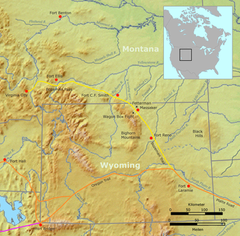 The North Platte River drainage has been an important westward route in the westward expansion of the United States
. To get the two essentials, water and grass for the traveler's animals the emigration trails nearly always followed river valleys across the North American continent. These trails extended from the Missouri River
, Platte River
and North Platte River across Nebraska
and parts of Wyoming
and on to its confluence with the Sweetwater River (Wyoming)
. About 50 miles (80.5 km) beyond what is now Casper, Wyoming
the main emigration trails left the North Platte valley and followed the Sweetwater River valley and other river valleys going further west.
The trail route along the North Platte River was first written about by Wilson Price Hunt of the Astor Expedition
who was traveling back to the Missouri River
from the newly established Fort Astoria
on the Columbia River
in 1811. The lack of American trappers and settlers in the contested Oregon Territory
resulted in this early discovery being unused and nearly forgotten. Jedediah Smith
and several trappers in 1823 rediscovered the route and the trail along the Platte, North Platte and Sweetwater Rivers became a major trail to the fur trader’s summer time Rocky Mountain Rendezvous. Mule trains carrying in trading supplies for the mountain men
and fur trappers were some of the first to use the trail in 1824. The fur traders on their return trip carried the traded furs back east at the end of the summer trading season. This fur trade route continued to be used to about 1840. By about 1832 the trail along the Platte, North Platte, and Sweetwater Rivers had been improved by the fur traders to a rough wagon trail from the Missouri River
to the Green River
in Wyoming where most of the Rocky Mountain Rendezvous occurred. Following the fur traders, the major emigration trails established along the north and south banks of the North Platte River were the Oregon
(1843–1869), California
(1843–1869), Mormon
(1847–1869) and the Bozeman
(1863–68) Trails. The trails north of the North Platte River originally crossed the North Platte near Fort Laramie to join the original Oregon and California Trail Route on the south side. In 1850 Child's Route (Child's Cutoff) extended the north side trail to what is now Casper, Wyoming
. The rugged territory from Laramie, Wyoming
to Casper, Wyoming
meant that the trails often deviated from the river to find an easier path and relied on streams draining into the North Platte for water.
valley, ringed by 12000 feet (3,657.6 m) mountains. The head of the river is essentially all of Jackson County, Colorado
whose boundaries are the continental divide
on the east and south and the mountain drainage peaks on the east—the north boundary is the state of Wyoming boundary. The rugged Rocky Mountains
Continental Divide surrounding Jackson County have at least twelve peaks over 11000 feet (3,352.8 m) in height. These peaks include on the west: Mount Zirkel 12180 feet (3,712.5 m), Lost ranger Peak 11932 feet (3,636.9 m) and Mount Ethel 11924 feet (3,634.4 m); on the south: Sheep Mountain 11819 feet (3,602.4 m) and Parkview Mountain 12296 feet (3,747.8 m)--whose waters on the south or east side drain into the North Platte River drainage. On the east are: Mount Nimbus 12706 feet (3,872.8 m), Mount Cumulus 12725 feet (3,878.6 m), Howard Mountain 12810 feet (3,904.5 m), Mount Cirrus 12797 feet (3,900.5 m), Mount Richthofen 12940 feet (3,944.1 m), Lead Mountain 12537 feet (3,821.3 m),North Diamond Peak 11852 feet (3,612.5 m) and Clark Peak 12951 feet (3,947.5 m) whose eastern slope waters drain into the North Platte River.
In Jackson county the North Platte is joined by several other small streams draining the mountains around the county. Some of these creeks are: Arapaho Creek, Colorado Creek, East Branch Illinois River, Jack Creek, Jewell Lake Trib., Grizzly Creek, Little Grizzly Creek, Norris Creek, North Fork of North Platte River, Rock Creek (Little Willow Ck), South Fork Canadian River, South Fork Michigan River, Willow Creek and in Wyoming the Encampment River
. All these streams are draining the snow melt form the mountains surrounding Jackson County. The North Platte River flows northward from Colorado into Wyoming through the popular rafting site--Northgate Canyon
which is along the western side of the Medicine Bow Mountains
.
In Colorado and Wyoming, the river is narrower and much swifter flowing than it is in Nebraska, where it becomes a slow flowing, shallow braided stream. The upper reaches of the river in the Rockies in Colorado and Wyoming are popular for recreation rafting and fly fishing
on the river and its many tributaries for rainbow trout
and other sport fish. In western Nebraska, the banks and riverbed of the North Platte provide a green oasis amid an otherwise semi-arid region of North America.
 The river has been dammed several times to form several reservoirs along its course. On the north end of the Park range it is joined by the Medicine Bow River
in the Seminoe Reservoir formed by Seminoe Dam
, further downstream is the Kortes Reservoir. Still further downstream about 50 miles (80.5 km) above Casper, Wyoming
the North Platte is joined by the Sweetwater River
to form the Pathfinder Reservoir
. Northeast of the Pathfinder Reservoir it passes through the Alcova and Gray Reef Reservoirs before it hits Casper, Wyoming
. Casper was established about 1860 east of the former site of Fort Caspar
, which was built about 1859 during the mass migration along the Oregon
, California
, Mormon
and Bozeman Trails.
Near what is now Casper was the location of several ferries that offered passage across the North Platte River during the summer "Trail season" starting about 1847. In 1847, during the first Mormon emigration, Brigham Young
leading the Mormon settlers to Salt Lake City, Utah
established a ferry near present day Casper known as the Mormon Ferry. The next year the ferry was moved a few miles down river. Soon competing ferries were built. In 1859, Louis Guinard built a toll bridge across the North Platte and a trading post near the original ferry's locations.
Before reaching Casper the river turns and flows northeast between the Granite Mountains
to the west and the Laramie Mountains
to the east.
The North Platte emerges from the mountains near Casper, Wyoming
, where it turns and flows east-southeast, along the northern edge of the Laramie Mountains
onto the Great Plains
. The North Platte flows east-southeast across the plains of eastern Wyoming, past the town of Douglas, Wyoming
and through Glendo
and Guernsey Reservoirs. It then flows past the Fort Laramie National Historic Site
(the former site of Fort Laramie), where it is joined by the Laramie River
. The North Platte is joined by Horse Creek flowing in from Wyoming near the Wyoming-Nebraska border as its last significant addition. It crosses into western Nebraska, flowing east-southeast between the cities of Scottsbluff, Nebraska
and Gering, Nebraska
. In Keith County, Nebraska
, the Kingsley Dam
forms Lake C.W. McConaughy, the largest reservoir in Nebraska and a significant irrigation
and recreation facility for the region. Kingsley Dam
, constructed in 1935 to 1941, is located on the east side of Lake McConaughy
in central Keith County, Nebraska
, and is the second largest hydraulic fill dam in the world. East of the Kingsley dam the North Platte River flows nearly parallel to the South Platte River
. In many places they are separated by only about 5 mi (8 km) for a stretch of about 50 mi (80 km) before they join to form the Platte River
just west of the city of North Platte, Nebraska
.
The wagon trails following the south side of the Platte/North Platte River ferried or waded in low water years across the swampy bottomed South Platte River
in several places to stay on the south side of the North Platte River where the trails were located. Those who later went on to Denver, Colorado
followed the South Platte River
trail into Colorado. Historically, the North Platte River used to be up to a mile wide (1.6 km) in many places as evidenced by the old streambed and written records. Today, by the time the North Platte reaches Paxton, Nebraska
it is much smaller due to the extensive water taken from it for irrigation.
Platte River
The Platte River is a major river in the state of Nebraska and is about long. Measured to its farthest source via its tributary the North Platte River, it flows for over . The Platte River is a tributary of the Missouri River, which in turn is a tributary of the Mississippi River which flows to...
and is approximately 716 miles (1,152.3 km) long counting its many curves, It travels about 550 miles (885.1 km) distance. Its course lies in the U.S. state
U.S. state
A U.S. state is any one of the 50 federated states of the United States of America that share sovereignty with the federal government. Because of this shared sovereignty, an American is a citizen both of the federal entity and of his or her state of domicile. Four states use the official title of...
s of Colorado
Colorado
Colorado is a U.S. state that encompasses much of the Rocky Mountains as well as the northeastern portion of the Colorado Plateau and the western edge of the Great Plains...
, Wyoming
Wyoming
Wyoming is a state in the mountain region of the Western United States. The western two thirds of the state is covered mostly with the mountain ranges and rangelands in the foothills of the Eastern Rocky Mountains, while the eastern third of the state is high elevation prairie known as the High...
, and Nebraska
Nebraska
Nebraska is a state on the Great Plains of the Midwestern United States. The state's capital is Lincoln and its largest city is Omaha, on the Missouri River....
before heading to the Atlantic Ocean
Atlantic Ocean
The Atlantic Ocean is the second-largest of the world's oceanic divisions. With a total area of about , it covers approximately 20% of the Earth's surface and about 26% of its water surface area...
.
The head of the river is essentially all of Jackson County, Colorado
Jackson County, Colorado
Jackson County is the fourth-least densely populated of the Colorado 64 counties of the U.S. state of Colorado. The county population was 1,577 at the 2000 Census. The county seat and the only municipality in the county is the Town of Walden.- History :...
whose boundaries are the continental divide
Continental divide
A continental divide is a drainage divide on a continent such that the drainage basin on one side of the divide feeds into one ocean or sea, and the basin on the other side either feeds into a different ocean or sea, or else is endorheic, not connected to the open sea...
on the east and south and the mountain drainage peaks on the east—the north boundary is the state of Wyoming boundary. The rugged Rocky Mountains
Rocky Mountains
The Rocky Mountains are a major mountain range in western North America. The Rocky Mountains stretch more than from the northernmost part of British Columbia, in western Canada, to New Mexico, in the southwestern United States...
surrounding Jackson County have at least twelve peaks over 11000 feet (3,352.8 m) in height. From Jackson County the river flows north about 200 miles (321.9 km) out of the Routt National Forest and North Park (Colorado basin)
North Park (Colorado basin)
North Park is a high, sparsely populated basin in the Rocky Mountains in north central Colorado in the United States. It encompasses a wide valley in Jackson County rimmed by mountain ranges at the headwaters of the North Platte River and several smaller tributaries, including the Michigan River,...
near what is now Walden, Colorado
Walden, Colorado
The Town of Walden is a Statutory Town that is the county seat of, and the only incorporated municipality in, Jackson County, Colorado, United States. It is situated in the center of a large open valley called North Park. People from Walden and the surrounding area refer to themselves as "North...
to Casper, Wyoming
Casper, Wyoming
Casper is the county seat of Natrona County, Wyoming, United States.. Casper is the second-largest city in Wyoming , according to the 2010 census, with a population of 55,316...
. Shortly after passing Casper the river turns to the east-southeast and flows about 350 miles (563.3 km) to the city of North Platte, Nebraska
North Platte, Nebraska
North Platte is a city in and the county seat of Lincoln County, Nebraska, United States. It is located in the southwestern part of the state, along Interstate 80, at the confluence of the North and South Platte Rivers forming the Platte River...
.
The North Platte and South Platte River
South Platte River
The South Platte River is one of the two principal tributaries of the Platte River and itself a major river of the American Midwest and the American Southwest/Mountain West, located in the U.S. states of Colorado and Nebraska...
join to form the Platte River
Platte River
The Platte River is a major river in the state of Nebraska and is about long. Measured to its farthest source via its tributary the North Platte River, it flows for over . The Platte River is a tributary of the Missouri River, which in turn is a tributary of the Mississippi River which flows to...
in western Nebraska near the city of North Platte, Nebraska
North Platte, Nebraska
North Platte is a city in and the county seat of Lincoln County, Nebraska, United States. It is located in the southwestern part of the state, along Interstate 80, at the confluence of the North and South Platte Rivers forming the Platte River...
. The Platte River
Platte River
The Platte River is a major river in the state of Nebraska and is about long. Measured to its farthest source via its tributary the North Platte River, it flows for over . The Platte River is a tributary of the Missouri River, which in turn is a tributary of the Mississippi River which flows to...
flows to the Missouri River
Missouri River
The Missouri River flows through the central United States, and is a tributary of the Mississippi River. It is the longest river in North America and drains the third largest area, though only the thirteenth largest by discharge. The Missouri's watershed encompasses most of the American Great...
which joins the Mississippi River
Mississippi River
The Mississippi River is the largest river system in North America. Flowing entirely in the United States, this river rises in western Minnesota and meanders slowly southwards for to the Mississippi River Delta at the Gulf of Mexico. With its many tributaries, the Mississippi's watershed drains...
to flow to the Gulf of Mexico
Gulf of Mexico
The Gulf of Mexico is a partially landlocked ocean basin largely surrounded by the North American continent and the island of Cuba. It is bounded on the northeast, north and northwest by the Gulf Coast of the United States, on the southwest and south by Mexico, and on the southeast by Cuba. In...
. The river provides the major avenue of drainage for northern Colorado, eastern Wyoming and western Nebraska. It is only navigable over most of its length at high water by canoe
Canoe
A canoe or Canadian canoe is a small narrow boat, typically human-powered, though it may also be powered by sails or small electric or gas motors. Canoes are usually pointed at both bow and stern and are normally open on top, but can be decked over A canoe (North American English) or Canadian...
s, kayak
Kayak
A kayak is a small, relatively narrow, human-powered boat primarily designed to be manually propelled by means of a double blade paddle.The traditional kayak has a covered deck and one or more cockpits, each seating one paddler...
s and rubber raft
Raft
A raft is any flat structure for support or transportation over water. It is the most basic of boat design, characterized by the absence of a hull...
s.
History as a Trail West
United States
The United States of America is a federal constitutional republic comprising fifty states and a federal district...
. To get the two essentials, water and grass for the traveler's animals the emigration trails nearly always followed river valleys across the North American continent. These trails extended from the Missouri River
Missouri River
The Missouri River flows through the central United States, and is a tributary of the Mississippi River. It is the longest river in North America and drains the third largest area, though only the thirteenth largest by discharge. The Missouri's watershed encompasses most of the American Great...
, Platte River
Platte River
The Platte River is a major river in the state of Nebraska and is about long. Measured to its farthest source via its tributary the North Platte River, it flows for over . The Platte River is a tributary of the Missouri River, which in turn is a tributary of the Mississippi River which flows to...
and North Platte River across Nebraska
Nebraska
Nebraska is a state on the Great Plains of the Midwestern United States. The state's capital is Lincoln and its largest city is Omaha, on the Missouri River....
and parts of Wyoming
Wyoming
Wyoming is a state in the mountain region of the Western United States. The western two thirds of the state is covered mostly with the mountain ranges and rangelands in the foothills of the Eastern Rocky Mountains, while the eastern third of the state is high elevation prairie known as the High...
and on to its confluence with the Sweetwater River (Wyoming)
Sweetwater River (Wyoming)
The Sweetwater River is a tributary of the North Platte River, long, in the U.S. state of Wyoming. Its waters eventually reach the Atlantic Ocean. The Sweetwater rises in southwestern Fremont County, at the continental divide near South Pass Wyoming, on the southern end of the Wind River Range...
. About 50 miles (80.5 km) beyond what is now Casper, Wyoming
Casper, Wyoming
Casper is the county seat of Natrona County, Wyoming, United States.. Casper is the second-largest city in Wyoming , according to the 2010 census, with a population of 55,316...
the main emigration trails left the North Platte valley and followed the Sweetwater River valley and other river valleys going further west.
The trail route along the North Platte River was first written about by Wilson Price Hunt of the Astor Expedition
Astor Expedition
The Astor Expedition of 1810-1812 was the next overland expedition from St. Louis, Missouri to the mouth of the Columbia River after the Corps of Discovery, led by Lewis and Clark.-History:...
who was traveling back to the Missouri River
Missouri River
The Missouri River flows through the central United States, and is a tributary of the Mississippi River. It is the longest river in North America and drains the third largest area, though only the thirteenth largest by discharge. The Missouri's watershed encompasses most of the American Great...
from the newly established Fort Astoria
Fort Astoria
Fort Astoria was the Pacific Fur Company's primary fur trading post in the Northwest, and was the first American-owned settlement on the Pacific coast. After a short two-year term of US ownership, the British owned and operated it for 33 years. It was the first British port on the Pacific coast...
on the Columbia River
Columbia River
The Columbia River is the largest river in the Pacific Northwest region of North America. The river rises in the Rocky Mountains of British Columbia, Canada, flows northwest and then south into the U.S. state of Washington, then turns west to form most of the border between Washington and the state...
in 1811. The lack of American trappers and settlers in the contested Oregon Territory
Oregon Territory
The Territory of Oregon was an organized incorporated territory of the United States that existed from August 14, 1848, until February 14, 1859, when the southwestern portion of the territory was admitted to the Union as the State of Oregon. Originally claimed by several countries , the region was...
resulted in this early discovery being unused and nearly forgotten. Jedediah Smith
Jedediah Smith
Jedediah Strong Smith was a hunter, trapper, fur trader, trailblazer, author, cartographer, cattleman, and explorer of the Rocky Mountains, the American West Coast and the Southwest during the 19th century...
and several trappers in 1823 rediscovered the route and the trail along the Platte, North Platte and Sweetwater Rivers became a major trail to the fur trader’s summer time Rocky Mountain Rendezvous. Mule trains carrying in trading supplies for the mountain men
Mountain man
Mountain men were trappers and explorers who roamed the North American Rocky Mountains from about 1810 through the 1880s where they were instrumental in opening up the various Emigrant Trails allowing Americans in the east to settle the new territories of the far west by organized wagon trains...
and fur trappers were some of the first to use the trail in 1824. The fur traders on their return trip carried the traded furs back east at the end of the summer trading season. This fur trade route continued to be used to about 1840. By about 1832 the trail along the Platte, North Platte, and Sweetwater Rivers had been improved by the fur traders to a rough wagon trail from the Missouri River
Missouri River
The Missouri River flows through the central United States, and is a tributary of the Mississippi River. It is the longest river in North America and drains the third largest area, though only the thirteenth largest by discharge. The Missouri's watershed encompasses most of the American Great...
to the Green River
Green River (Utah)
The Green River, located in the western United States, is the chief tributary of the Colorado River. The watershed of the river, known as the Green River Basin, covers parts of Wyoming, Utah, and Colorado. The Green River is long, beginning in the Wind River Mountains of Wyoming and flowing...
in Wyoming where most of the Rocky Mountain Rendezvous occurred. Following the fur traders, the major emigration trails established along the north and south banks of the North Platte River were the Oregon
Oregon Trail
The Oregon Trail is a historic east-west wagon route that connected the Missouri River to valleys in Oregon and locations in between.After 1840 steam-powered riverboats and steamboats traversing up and down the Ohio, Mississippi and Missouri rivers sped settlement and development in the flat...
(1843–1869), California
California Trail
The California Trail was an emigrant trail of about across the western half of the North American continent from Missouri River towns to what is now the state of California...
(1843–1869), Mormon
Mormon Trail
The Mormon Trail or Mormon Pioneer Trail is the 1,300 mile route that members of The Church of Jesus Christ of Latter-day Saints traveled from 1846 to 1868...
(1847–1869) and the Bozeman
Bozeman Trail
The Bozeman Trail was an overland route connecting the gold rush territory of Montana to the Oregon Trail. Its most important period was from 1863-1868. The flow of pioneers and settlers through territory of American Indians provoked their resentment and caused attacks. The U.S. Army undertook...
(1863–68) Trails. The trails north of the North Platte River originally crossed the North Platte near Fort Laramie to join the original Oregon and California Trail Route on the south side. In 1850 Child's Route (Child's Cutoff) extended the north side trail to what is now Casper, Wyoming
Casper, Wyoming
Casper is the county seat of Natrona County, Wyoming, United States.. Casper is the second-largest city in Wyoming , according to the 2010 census, with a population of 55,316...
. The rugged territory from Laramie, Wyoming
Laramie, Wyoming
Laramie is a city in and the county seat of Albany County, Wyoming, United States. The population was 30,816 at the . Located on the Laramie River in southeastern Wyoming, the city is west of Cheyenne, at the junction of Interstate 80 and U.S. Route 287....
to Casper, Wyoming
Casper, Wyoming
Casper is the county seat of Natrona County, Wyoming, United States.. Casper is the second-largest city in Wyoming , according to the 2010 census, with a population of 55,316...
meant that the trails often deviated from the river to find an easier path and relied on streams draining into the North Platte for water.
River Description
Up in central north Colorado rests a North Park (Colorado basin)North Park (Colorado basin)
North Park is a high, sparsely populated basin in the Rocky Mountains in north central Colorado in the United States. It encompasses a wide valley in Jackson County rimmed by mountain ranges at the headwaters of the North Platte River and several smaller tributaries, including the Michigan River,...
valley, ringed by 12000 feet (3,657.6 m) mountains. The head of the river is essentially all of Jackson County, Colorado
Jackson County, Colorado
Jackson County is the fourth-least densely populated of the Colorado 64 counties of the U.S. state of Colorado. The county population was 1,577 at the 2000 Census. The county seat and the only municipality in the county is the Town of Walden.- History :...
whose boundaries are the continental divide
Continental divide
A continental divide is a drainage divide on a continent such that the drainage basin on one side of the divide feeds into one ocean or sea, and the basin on the other side either feeds into a different ocean or sea, or else is endorheic, not connected to the open sea...
on the east and south and the mountain drainage peaks on the east—the north boundary is the state of Wyoming boundary. The rugged Rocky Mountains
Rocky Mountains
The Rocky Mountains are a major mountain range in western North America. The Rocky Mountains stretch more than from the northernmost part of British Columbia, in western Canada, to New Mexico, in the southwestern United States...
Continental Divide surrounding Jackson County have at least twelve peaks over 11000 feet (3,352.8 m) in height. These peaks include on the west: Mount Zirkel 12180 feet (3,712.5 m), Lost ranger Peak 11932 feet (3,636.9 m) and Mount Ethel 11924 feet (3,634.4 m); on the south: Sheep Mountain 11819 feet (3,602.4 m) and Parkview Mountain 12296 feet (3,747.8 m)--whose waters on the south or east side drain into the North Platte River drainage. On the east are: Mount Nimbus 12706 feet (3,872.8 m), Mount Cumulus 12725 feet (3,878.6 m), Howard Mountain 12810 feet (3,904.5 m), Mount Cirrus 12797 feet (3,900.5 m), Mount Richthofen 12940 feet (3,944.1 m), Lead Mountain 12537 feet (3,821.3 m),North Diamond Peak 11852 feet (3,612.5 m) and Clark Peak 12951 feet (3,947.5 m) whose eastern slope waters drain into the North Platte River.
In Jackson county the North Platte is joined by several other small streams draining the mountains around the county. Some of these creeks are: Arapaho Creek, Colorado Creek, East Branch Illinois River, Jack Creek, Jewell Lake Trib., Grizzly Creek, Little Grizzly Creek, Norris Creek, North Fork of North Platte River, Rock Creek (Little Willow Ck), South Fork Canadian River, South Fork Michigan River, Willow Creek and in Wyoming the Encampment River
Encampment River
The Encampment River is a tributary of the North Platte River. The river's source is east of Buck Mountain in the Park Range of Jackson County, Colorado. The river flows north and passes through the town of Encampment, Wyoming before its confluence with the North Platte....
. All these streams are draining the snow melt form the mountains surrounding Jackson County. The North Platte River flows northward from Colorado into Wyoming through the popular rafting site--Northgate Canyon
Northgate Canyon
thumb|Calm section of Northgate Canyon in low-water conditionsNorthgate Canyon is the long stretch of the North Platte River between Routt Access and Six-Mile Gap .-Description:...
which is along the western side of the Medicine Bow Mountains
Medicine Bow Mountains
The Medicine Bow Mountains are a mountain range in the Rocky Mountains that extend for from northern Colorado into southern Wyoming. The northern extent of this range is the sub-range the Snowy Range...
.
In Colorado and Wyoming, the river is narrower and much swifter flowing than it is in Nebraska, where it becomes a slow flowing, shallow braided stream. The upper reaches of the river in the Rockies in Colorado and Wyoming are popular for recreation rafting and fly fishing
Fly fishing
Fly fishing is an angling method in which an artificial 'fly' is used to catch fish. The fly is cast using a fly rod, reel, and specialized weighted line. Casting a nearly weightless fly or 'lure' requires casting techniques significantly different from other forms of casting...
on the river and its many tributaries for rainbow trout
Rainbow trout
The rainbow trout is a species of salmonid native to tributaries of the Pacific Ocean in Asia and North America. The steelhead is a sea run rainbow trout usually returning to freshwater to spawn after 2 to 3 years at sea. In other words, rainbow trout and steelhead trout are the same species....
and other sport fish. In western Nebraska, the banks and riverbed of the North Platte provide a green oasis amid an otherwise semi-arid region of North America.
Medicine Bow River
The Medicine Bow River is a tributary of the North Platte River, in southern Wyoming in the United States.It rises in the Snowy Range, flowing out of the North Gap Lake, in southeastern Carbon County...
in the Seminoe Reservoir formed by Seminoe Dam
Seminoe Dam
Seminoe Dam is a concrete arch dam on the North Platte River in the U.S. state of Wyoming. The dam stores irrigation water and generates hydroelectricity, and is owned and operated by the U.S. Bureau of Reclamation. It lies in a narrow canyon in the semiarid, windswept hinterlands of the...
, further downstream is the Kortes Reservoir. Still further downstream about 50 miles (80.5 km) above Casper, Wyoming
Casper, Wyoming
Casper is the county seat of Natrona County, Wyoming, United States.. Casper is the second-largest city in Wyoming , according to the 2010 census, with a population of 55,316...
the North Platte is joined by the Sweetwater River
Sweetwater River (Wyoming)
The Sweetwater River is a tributary of the North Platte River, long, in the U.S. state of Wyoming. Its waters eventually reach the Atlantic Ocean. The Sweetwater rises in southwestern Fremont County, at the continental divide near South Pass Wyoming, on the southern end of the Wind River Range...
to form the Pathfinder Reservoir
Pathfinder Reservoir
Pathfinder Reservoir is located in the U.S. state of Wyoming on the North Platte River between Casper and Rawlins. It sits 47 miles southwest of Casper, in Carbon County and Natrona County. The reservoir was created by Pathfinder Dam and has a storage capacity of . The shoreline consists of 117...
. Northeast of the Pathfinder Reservoir it passes through the Alcova and Gray Reef Reservoirs before it hits Casper, Wyoming
Casper, Wyoming
Casper is the county seat of Natrona County, Wyoming, United States.. Casper is the second-largest city in Wyoming , according to the 2010 census, with a population of 55,316...
. Casper was established about 1860 east of the former site of Fort Caspar
Fort Caspar
Fort Caspar was a military post of the United States Army in present-day Wyoming, named after 2nd Lieutenant Caspar Collins, a U.S. Army officer who was killed in the 1865 Battle of the Platte Bridge Station against the Lakota and Cheyenne...
, which was built about 1859 during the mass migration along the Oregon
Oregon Trail
The Oregon Trail is a historic east-west wagon route that connected the Missouri River to valleys in Oregon and locations in between.After 1840 steam-powered riverboats and steamboats traversing up and down the Ohio, Mississippi and Missouri rivers sped settlement and development in the flat...
, California
California Trail
The California Trail was an emigrant trail of about across the western half of the North American continent from Missouri River towns to what is now the state of California...
, Mormon
Mormon Trail
The Mormon Trail or Mormon Pioneer Trail is the 1,300 mile route that members of The Church of Jesus Christ of Latter-day Saints traveled from 1846 to 1868...
and Bozeman Trails.
Near what is now Casper was the location of several ferries that offered passage across the North Platte River during the summer "Trail season" starting about 1847. In 1847, during the first Mormon emigration, Brigham Young
Brigham Young
Brigham Young was an American leader in the Latter Day Saint movement and a settler of the Western United States. He was the President of The Church of Jesus Christ of Latter-day Saints from 1847 until his death in 1877, he founded Salt Lake City, and he served as the first governor of the Utah...
leading the Mormon settlers to Salt Lake City, Utah
Salt Lake City, Utah
Salt Lake City is the capital and the most populous city of the U.S. state of Utah. The name of the city is often shortened to Salt Lake or SLC. With a population of 186,440 as of the 2010 Census, the city lies in the Salt Lake City metropolitan area, which has a total population of 1,124,197...
established a ferry near present day Casper known as the Mormon Ferry. The next year the ferry was moved a few miles down river. Soon competing ferries were built. In 1859, Louis Guinard built a toll bridge across the North Platte and a trading post near the original ferry's locations.
Before reaching Casper the river turns and flows northeast between the Granite Mountains
Granite Mountains (Wyoming)
The Granite Mountains are a short subrange of the Rocky Mountains in central Wyoming of the United States. The range runs approximately 100 mi E-W along the south side of the Shoshone Basin, and north of the Sweetwater River, in eastern Fremont County and western Natrona County. The highest...
to the west and the Laramie Mountains
Laramie Mountains
The Laramie Mountains are a range of moderately high peaks on the eastern edge of the Rocky Mountains in the U.S states of Wyoming and Colorado. The range is the northernmost extension of the line of the ranges along the eastern side of the Rockies, and in particular of the higher peaks of the...
to the east.
The North Platte emerges from the mountains near Casper, Wyoming
Casper, Wyoming
Casper is the county seat of Natrona County, Wyoming, United States.. Casper is the second-largest city in Wyoming , according to the 2010 census, with a population of 55,316...
, where it turns and flows east-southeast, along the northern edge of the Laramie Mountains
Laramie Mountains
The Laramie Mountains are a range of moderately high peaks on the eastern edge of the Rocky Mountains in the U.S states of Wyoming and Colorado. The range is the northernmost extension of the line of the ranges along the eastern side of the Rockies, and in particular of the higher peaks of the...
onto the Great Plains
Great Plains
The Great Plains are a broad expanse of flat land, much of it covered in prairie, steppe and grassland, which lies west of the Mississippi River and east of the Rocky Mountains in the United States and Canada. This area covers parts of the U.S...
. The North Platte flows east-southeast across the plains of eastern Wyoming, past the town of Douglas, Wyoming
Douglas, Wyoming
Douglas is a city in Converse County, Wyoming, United States. The population was 5,288 at the 2000 census. It is the county seat of Converse County...
and through Glendo
Glendo Reservoir
Glendo Reservoir is a reservoir located on the North Platte River in Platte County and Converse County in the U.S. State of Wyoming. The reservoir is formed by Glendo Dam . The earthfill dam is feet long and high and contains two hydroelectric turbines capable of generating 38 megawatts of power...
and Guernsey Reservoirs. It then flows past the Fort Laramie National Historic Site
Fort Laramie National Historic Site
Fort Laramie was a significant 19th century trading post and diplomatic site located at the confluence of the Laramie River and the North Platte River in the upper Platte River Valley in the eastern part of the U.S. state of Wyoming...
(the former site of Fort Laramie), where it is joined by the Laramie River
Laramie River
The Laramie River is a tributary of the North Platte River, approximately long, in the U.S. states of Colorado and Wyoming.It rises in northern Colorado, in the Roosevelt National Forest in the Front Range, in western Larimer County...
. The North Platte is joined by Horse Creek flowing in from Wyoming near the Wyoming-Nebraska border as its last significant addition. It crosses into western Nebraska, flowing east-southeast between the cities of Scottsbluff, Nebraska
Scottsbluff, Nebraska
Scottsbluff is a city in Scotts Bluff County, Nebraska, United States. The population was 15,039 at the 2010 census. Scottsbluff is the largest city in the Nebraska Panhandle, and the 13th largest city in Nebraska....
and Gering, Nebraska
Gering, Nebraska
Gering is a city in Scotts Bluff County, Nebraska, United States. It is part of the Scottsbluff, Nebraska Micropolitan Statistical Area. The population was 7,751 at the 2000 census. It is the county seat of Scotts Bluff County....
. In Keith County, Nebraska
Keith County, Nebraska
-History:Keith County was formed in 1873. It was named after Morrill C. Keith, the grandfather of Governor Keith Neville.-Demographics:As of the census of 2000, there were 8,875 people, 3,707 households, and 2,535 families residing in the county. The population density was 8 people per square mile...
, the Kingsley Dam
Kingsley Dam
Kingsley Dam is located on the east side of Lake McConaughy in central Keith County, Nebraska, and is the second largest hydraulic fill dam in the world. It was built as part of the New Deal project. The dam is tall, long, and 1,100 wide at its base. On the east side of the dam is Lake Ogallala...
forms Lake C.W. McConaughy, the largest reservoir in Nebraska and a significant irrigation
Irrigation
Irrigation may be defined as the science of artificial application of water to the land or soil. It is used to assist in the growing of agricultural crops, maintenance of landscapes, and revegetation of disturbed soils in dry areas and during periods of inadequate rainfall...
and recreation facility for the region. Kingsley Dam
Kingsley Dam
Kingsley Dam is located on the east side of Lake McConaughy in central Keith County, Nebraska, and is the second largest hydraulic fill dam in the world. It was built as part of the New Deal project. The dam is tall, long, and 1,100 wide at its base. On the east side of the dam is Lake Ogallala...
, constructed in 1935 to 1941, is located on the east side of Lake McConaughy
Lake McConaughy
Lake McConaughy is a reservoir on the North Platte River. It is located north of Ogallala, Nebraska, United States, near U.S. Highway 26 and Nebraska Highway 61. The reservoir was named for Charles W. McConaughy, a grain merchant and mayor of Holdrege, Nebraska, one of the leading promoters of...
in central Keith County, Nebraska
Keith County, Nebraska
-History:Keith County was formed in 1873. It was named after Morrill C. Keith, the grandfather of Governor Keith Neville.-Demographics:As of the census of 2000, there were 8,875 people, 3,707 households, and 2,535 families residing in the county. The population density was 8 people per square mile...
, and is the second largest hydraulic fill dam in the world. East of the Kingsley dam the North Platte River flows nearly parallel to the South Platte River
South Platte River
The South Platte River is one of the two principal tributaries of the Platte River and itself a major river of the American Midwest and the American Southwest/Mountain West, located in the U.S. states of Colorado and Nebraska...
. In many places they are separated by only about 5 mi (8 km) for a stretch of about 50 mi (80 km) before they join to form the Platte River
Platte River
The Platte River is a major river in the state of Nebraska and is about long. Measured to its farthest source via its tributary the North Platte River, it flows for over . The Platte River is a tributary of the Missouri River, which in turn is a tributary of the Mississippi River which flows to...
just west of the city of North Platte, Nebraska
North Platte, Nebraska
North Platte is a city in and the county seat of Lincoln County, Nebraska, United States. It is located in the southwestern part of the state, along Interstate 80, at the confluence of the North and South Platte Rivers forming the Platte River...
.
The wagon trails following the south side of the Platte/North Platte River ferried or waded in low water years across the swampy bottomed South Platte River
South Platte River
The South Platte River is one of the two principal tributaries of the Platte River and itself a major river of the American Midwest and the American Southwest/Mountain West, located in the U.S. states of Colorado and Nebraska...
in several places to stay on the south side of the North Platte River where the trails were located. Those who later went on to Denver, Colorado
Denver, Colorado
The City and County of Denver is the capital and the most populous city of the U.S. state of Colorado. Denver is a consolidated city-county, located in the South Platte River Valley on the western edge of the High Plains just east of the Front Range of the Rocky Mountains...
followed the South Platte River
South Platte River
The South Platte River is one of the two principal tributaries of the Platte River and itself a major river of the American Midwest and the American Southwest/Mountain West, located in the U.S. states of Colorado and Nebraska...
trail into Colorado. Historically, the North Platte River used to be up to a mile wide (1.6 km) in many places as evidenced by the old streambed and written records. Today, by the time the North Platte reaches Paxton, Nebraska
Paxton, Nebraska
Paxton is a village in Keith County, Nebraska, United States. The population was 614 at the 2000 census.-Geography:According to the United States Census Bureau, the village has a total area of , all of it land.-Demographics:...
it is much smaller due to the extensive water taken from it for irrigation.
See also
- List of longest rivers of the United States (by main stem)
- List of rivers of Colorado
- List of rivers of Wyoming
- List of rivers of Nebraska