
Paiute
Encyclopedia
Paiute refers to three closely related groups of Native Americans
— the Northern Paiute of California
, Idaho
, Nevada
and Oregon
; the Owens Valley Paiute of California and Nevada; and the Southern Paiute of Arizona
, southeastern California and Nevada, and Utah
.
explorers called the Southern Paiute Payuchi (they did not make contact with the Northern Paiute). Early Euro-American settlers often called both groups of Paiute "Diggers" (presumably because of their practice of digging for roots). As the Paiute consider the term derogatory, they discourage its use.
of Native American languages. Usage of the terms Paiute, Northern Paiute and Southern Paiute is most correct when referring to groups of people with similar language and culture. It does not imply a political connection or even an especially close genetic relationship. The Northern Paiute speak the Northern Paiute language
, while the Southern Paiute speak the Ute-Southern Paiute language. These languages are not as closely related to each other as they are to other Numic languages
.
The Bannock
, Mono tribe
, and Coso People
, Timbisha
and Kawaiisu
peoples, who also speak Numic languages and live in adjacent areas, are sometimes referred to as Paiute. The Bannock speak a dialect of Northern Paiute, while the Mono Tribe and other three peoples speak separate Numic languages: Mono language
is more closely related to Northern Paiute, as is Coso; Timbisha language
is more closely related to Shoshoni
, and Kawaiisu language
is more closely related to Ute-Southern Paiute.
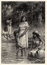
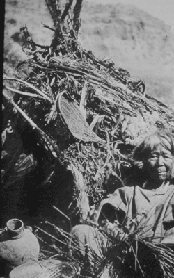
The Northern Paiute traditionally have lived in the Great Basin
in eastern California, western Nevada, and southeast Oregon. The Northern Paiute's pre-contact lifestyle was well adapted to the harsh desert
environment in which they lived. Each tribe or band occupied a specific territory, generally centered on a lake
or wetland
that supplied fish and water-fowl. Rabbit
s and pronghorn
were taken from surrounding areas in communal drives, which often involved neighboring bands. Individuals and families appear to have moved freely between bands. Pinyon
nuts gathered in the mountains in the fall provided critical winter food. Grass seeds and roots were also important parts of their diet. The name of each band came from a characteristic food source. For example, the people at Pyramid Lake were known as the Cui Ui Ticutta (meaning "Cui-ui
eaters"), the people of the Lovelock
area were known as the Koop Ticutta, meaning "ground-squirrel eaters," and the people of the Carson Sink
were known as the Toi Ticutta, meaning "tule
eaters." The Kucadikadi
of Mono County, California
are the "brine fly eaters."
 Relations among the Northern Paiute bands and their Shoshone neighbors were generally peaceful. There is no sharp distinction between the Northern Paiute and Western Shoshone. Relations with the Washoe people, who were culturally and linguistically very different, were not so peaceful.
 Sustained contact between the Northern Paiute and Euro-Americans came in the early 1840s, although the first contact may have occurred as early as the 1820s. Although the Paiute had adopted the use of horses from other Great Plains tribes, their culture was otherwise largely unaffected by European influences at that point. As Euro-American settlement of the area progressed, several violent incidents occurred, including the Pyramid Lake War of 1860, Owens Valley Indian War
1861-1864, Snake War
1864-1868; and the Bannock War
of 1878. These incidents generally began with a disagreement between settlers and the Paiute (singly or in a group) regarding property, retaliation by one group against the other, and finally counter-retaliation by the opposite party, frequently culminating in the armed involvement of the U.S. Army
. Many more Paiutes died from newly introduced infectious diseases such as smallpox
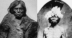
than in warfare. Sarah Winnemucca
's book Life Among the Piutes (1883) gives a first-hand account of this period, although it is not considered to be wholly reliable.
The government first established the Malheur Reservation
for the Northern Paiute in eastern Oregon. The federal government's intention was to concentrate the Northern Paiute there, but its strategy did not work. Because of the distance of the reservation from the traditional areas of most of the bands, and because of its poor environmental conditions, many Northern Paiute refused to go there. Those that did, soon left. They clung to their traditional lifestyle as long as possible; when environmental degradation made that impossible, they sought jobs on white farms, ranches or in cities. They established small Indian colonies
, where they were joined by many Shoshone and, in the Reno
area, Washoe people.
Later, the government created larger reservations at Pyramid Lake
and Duck Valley
, Nevada
. By that time the pattern of small de facto reservations near cities or farm districts, often with mixed Northern Paiute and Shoshone populations, had been established. Starting in the early 20th century, the federal government began granting land to these colonies. Under the Indian Reorganization Act
of 1934, several individual colonies gained federal recognition as independent tribes.
thought that the 1770 population of the Northern Paiute within California was 500. He estimated their population in 1910 as 300. Others put the total Northern Paiute population in 1859 at about 6,000.
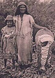
Owens Valley Paiute live on the California-Nevada border, near the Owens River
on the eastern side of the southern Sierra Nevada Mountains in the Owens Valley
and speak the Mono language
. Their self-designation is Numa, meaning ‘People’ or Nün‘wa Paya Hup Ca’a‘ Otuu’mu - ‘Coyotes children living in the water ditch’
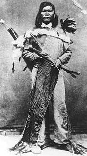
 The Southern Paiute traditionally lived in the Colorado River
basin and Mojave Desert
in northern Arizona
and southeastern California including Owens Valley
, southern Nevada and southern Utah. Terminated
as a tribe in 1954 under federal efforts at assimilation, the Southern Paiute regained federal recognition in 1980. Many of these Paiute traded with coastal tribes; for example, tribes of the Owens Valley have been proven to trade with the Chumash of the Central Coast
, based upon archaeological recovery at Morro Creek
. A band of Southern Paiute at Willow Springs and Navajo Mountain
, south of the Grand Canyon
, reside inside the Navajo Indian Reservation. These "San Juan Paiute" were officially recognized as a separate tribe by the Bureau of Indian Affairs
in 1980.
The first European contact with the Southern Paiute occurred in 1776, when fathers Silvestre Vélez de Escalante and Francisco Atanasio Domínguez encountered them during an attempt to find an overland route to the missions of California
. Before this date, the Southern Paiute suffered slave raids by the Navajo
and the Ute
. The arrival of Spanish and later Euro-american explorers into their territory increased slave raiding by other tribes. In 1851, Mormon
settlers strategically occupied Paiute water sources, which created a dependency relationship. But, the presence of Mormon settlers soon ended the slave raids, and relations between the Paiutes and the Mormons were basically peaceful. The Mormon missionary
Jacob Hamblin
worked at diplomatic efforts. The introduction of European settlers and agricultural practices (most especially large herds of cattle
) made it difficult for the Southern Paiute to continue their traditional lifestyle, as it drove away the game and reduced their ability to hunt, as well as to gather natural foods.
Today Southern Paiute communities are located at Las Vegas
, Pahrump
, and Moapa
, in Nevada
; Cedar City
, Kanosh
, Koosharem
, Shivwits, and Indian Peaks, in Utah
; at Kaibab
and Willow Springs, in Arizona
; Death Valley
and at the Chemehuevi Indian Reservation and on the Colorado River Indian Reservation
in California
. Some would include the 29 Palms
Reservation in Riverside County
, California
.
 The Southern Paiute traditionally had sixteen to 31 subgroups, bands, or tribes.
. It took place from May through June 1860, though sporadic violence continued for a period afterward.
Native Americans in the United States
Native Americans in the United States are the indigenous peoples in North America within the boundaries of the present-day continental United States, parts of Alaska, and the island state of Hawaii. They are composed of numerous, distinct tribes, states, and ethnic groups, many of which survive as...
— the Northern Paiute of California
California
California is a state located on the West Coast of the United States. It is by far the most populous U.S. state, and the third-largest by land area...
, Idaho
Idaho
Idaho is a state in the Rocky Mountain area of the United States. The state's largest city and capital is Boise. Residents are called "Idahoans". Idaho was admitted to the Union on July 3, 1890, as the 43rd state....
, Nevada
Nevada
Nevada is a state in the western, mountain west, and southwestern regions of the United States. With an area of and a population of about 2.7 million, it is the 7th-largest and 35th-most populous state. Over two-thirds of Nevada's people live in the Las Vegas metropolitan area, which contains its...
and Oregon
Oregon
Oregon is a state in the Pacific Northwest region of the United States. It is located on the Pacific coast, with Washington to the north, California to the south, Nevada on the southeast and Idaho to the east. The Columbia and Snake rivers delineate much of Oregon's northern and eastern...
; the Owens Valley Paiute of California and Nevada; and the Southern Paiute of Arizona
Arizona
Arizona ; is a state located in the southwestern region of the United States. It is also part of the western United States and the mountain west. The capital and largest city is Phoenix...
, southeastern California and Nevada, and Utah
Utah
Utah is a state in the Western United States. It was the 45th state to join the Union, on January 4, 1896. Approximately 80% of Utah's 2,763,885 people live along the Wasatch Front, centering on Salt Lake City. This leaves vast expanses of the state nearly uninhabited, making the population the...
.
Origin of name
The origin of the word Paiute is unclear. Some anthropologists have interpreted it as "Water Ute" or "True Ute." The Northern Paiute call themselves Numa (sometimes written Numu); the Southern Paiute call themselves Nuwuvi. Both terms mean "the people." The Northern Paiute are sometimes referred to as Paviotso. Early SpanishSpanish people
The Spanish are citizens of the Kingdom of Spain. Within Spain, there are also a number of vigorous nationalisms and regionalisms, reflecting the country's complex history....
explorers called the Southern Paiute Payuchi (they did not make contact with the Northern Paiute). Early Euro-American settlers often called both groups of Paiute "Diggers" (presumably because of their practice of digging for roots). As the Paiute consider the term derogatory, they discourage its use.
Language and culture
The Northern and Southern Paiute both speak languages belonging to the Numic branch of the Uto-Aztecan familyUto-Aztecan languages
Uto-Aztecan or Uto-Aztekan is a Native American language family consisting of over 30 languages. Uto-Aztecan languages are found from the Great Basin of the Western United States , through western, central and southern Mexico Uto-Aztecan or Uto-Aztekan is a Native American language family...
of Native American languages. Usage of the terms Paiute, Northern Paiute and Southern Paiute is most correct when referring to groups of people with similar language and culture. It does not imply a political connection or even an especially close genetic relationship. The Northern Paiute speak the Northern Paiute language
Northern Paiute language
Northern Paiute is a Western Numic language of the Uto-Aztecan family, which according to Marianne Mithun had around 500 fluent speakers in 1994. Ethnologue reported the number of speakers in 1999 as 1,631...
, while the Southern Paiute speak the Ute-Southern Paiute language. These languages are not as closely related to each other as they are to other Numic languages
Numic languages
Numic is a branch of the Uto-Aztecan language family. It includes seven languages spoken by Native American peoples traditionally living in the Great Basin, Colorado River basin, and southern Great Plains. The word Numic comes from the cognate word in all Numic languages for "person." For...
.
The Bannock
Bannock (tribe)
The Bannock tribe of the Northern Paiute are an indigenous people of the Great Basin. Their traditional lands include southeastern Oregon, southeastern Idaho, western Wyoming, and southwestern Montana...
, Mono tribe
Mono tribe
The Mono are a Native American people who traditionally live in the central Sierra Nevada Mountains, the Eastern Sierra , the Mono Basin, and adjacent areas of the Great Basin.-Culture and geography:...
, and Coso People
Coso People
The Coso people are an indigenous people of the Americas and Native American tribe associated with the Coso Range in the Mojave Desert of California in the southwestern U.S.. They are of the Uto-Aztecan language and spoke one of several Numic languages, related to that of the Northern Paiute.They...
, Timbisha
Timbisha
The Timbisha are a Native American tribe federally recognized as the Death Valley Timbisha Shoshone Band of California. They are known as the Timbisha Shoshone Tribe and are located in south central California, near the Nevada border.-History:The Timbisha have lived in the Death Valley region of...
and Kawaiisu
Kawaiisu
thumb|Kawaiisu FamilyThe Kawaiisu are a Native American group who lived in the southern California Tehachapi Valley and across the Tehachapi Pass in the southern Sierra Nevada Mountains to the north, toward Lake Isabella and Walker Pass...
peoples, who also speak Numic languages and live in adjacent areas, are sometimes referred to as Paiute. The Bannock speak a dialect of Northern Paiute, while the Mono Tribe and other three peoples speak separate Numic languages: Mono language
Mono language (Native American)
Mono is a Native American language of the Numic group of Uto-Aztecan languages, the ancestral language of the Mono people. Mono consists of two dialects, Eastern and Western. The name "Monachi" is commonly used in reference to Western Mono and "Owens Valley Paiute" in reference to Eastern Mono....
is more closely related to Northern Paiute, as is Coso; Timbisha language
Timbisha language
The Timbisha language is the language of the Native American people who have inhabited the region in and around Death Valley, California and the southern Owens Valley since late prehistoric times...
is more closely related to Shoshoni
Shoshone language
Shoshoni or Shoshone is a Native American language spoken by the Shoshone people. Principal dialects of Shoshoni include Western Shoshoni in Nevada, Gosiute in western Utah, Northern Shoshoni in southern Idaho and northern Utah, and Eastern Shoshoni in Wyoming.Shoshoni-speaking Native Americans...
, and Kawaiisu language
Kawaiisu language
The Kawaiisu language is an Uto-Aztecan language spoken by the Kawaiisu people of California.-Classification:Kawaiisu is a member of the Southern Numic division of the Uto-Aztecan language family.-Linguistic Environment:...
is more closely related to Ute-Southern Paiute.
Northern Paiute
The Northern Paiute traditionally have lived in the Great Basin
Great Basin
The Great Basin is the largest area of contiguous endorheic watersheds in North America and is noted for its arid conditions and Basin and Range topography that varies from the North American low point at Badwater Basin to the highest point of the contiguous United States, less than away at the...
in eastern California, western Nevada, and southeast Oregon. The Northern Paiute's pre-contact lifestyle was well adapted to the harsh desert
Desert
A desert is a landscape or region that receives an extremely low amount of precipitation, less than enough to support growth of most plants. Most deserts have an average annual precipitation of less than...
environment in which they lived. Each tribe or band occupied a specific territory, generally centered on a lake
Lake
A lake is a body of relatively still fresh or salt water of considerable size, localized in a basin, that is surrounded by land. Lakes are inland and not part of the ocean and therefore are distinct from lagoons, and are larger and deeper than ponds. Lakes can be contrasted with rivers or streams,...
or wetland
Wetland
A wetland is an area of land whose soil is saturated with water either permanently or seasonally. Wetlands are categorised by their characteristic vegetation, which is adapted to these unique soil conditions....
that supplied fish and water-fowl. Rabbit
Rabbit
Rabbits are small mammals in the family Leporidae of the order Lagomorpha, found in several parts of the world...
s and pronghorn
Pronghorn
The pronghorn is a species of artiodactyl mammal endemic to interior western and central North America. Though not an antelope, it is often known colloquially in North America as the prong buck, pronghorn antelope, or simply antelope, as it closely resembles the true antelopes of the Old World and...
were taken from surrounding areas in communal drives, which often involved neighboring bands. Individuals and families appear to have moved freely between bands. Pinyon
Pinyon pine
The pinyon pine group grows in the southwestern United States and in Mexico. The trees yield edible pinyon nuts, which were a staple of the Native Americans, and are still widely eaten...
nuts gathered in the mountains in the fall provided critical winter food. Grass seeds and roots were also important parts of their diet. The name of each band came from a characteristic food source. For example, the people at Pyramid Lake were known as the Cui Ui Ticutta (meaning "Cui-ui
Cui-ui
The cui-ui, Chasmistes cujus, is a large sucker fish endemic to Pyramid Lake and, prior to its desiccation in the 20th century, Winnemucca Lake in northwestern Nevada. It feeds primarily on zooplankton and possibly on nanoplankton...
eaters"), the people of the Lovelock
Lovelock, Nevada
Lovelock is a city in western Nevada that is the county seat of Pershing County, the location of a prison, and the namesake of the area's Cold War gunnery range...
area were known as the Koop Ticutta, meaning "ground-squirrel eaters," and the people of the Carson Sink
Carson Sink
Carson Sink is a playa in the northeastern portion of the Carson Desert that was formerly the terminus of the Carson River. The sink is currently fed by drainage canals of the Truckee-Carson Irrigation District...
were known as the Toi Ticutta, meaning "tule
Tule
Schoenoplectus acutus , called tule , common tule, hardstem tule, tule rush, hardstem bulrush, or viscid bulrush, is a giant species of sedge in the plant family Cyperaceae, native to freshwater marshes all over North America...
eaters." The Kucadikadi
Kucadikadi
The Kucadikadi are a band of Northern Paiute people who live near Mono Lake in Mono County, California. They are the southernmost band of Northern Paiute.-Name:...
of Mono County, California
Mono County, California
Mono County is a county located in the east central portion of the U.S. state of California, to the east of the Sierra Nevada between Yosemite National Park and Nevada. As of the 2010 census, the population was 14,202, up from 12,853 at the 2000 census...
are the "brine fly eaters."
Owens Valley Indian War
The Owens Valley War was fought between 1862 and 1863, by California Volunteers and local settlers against the Owens Valley Paiutes, and their Shoshone and Kawaiisu allies, in the Owens Valley of California and the southwestern Nevada border region. The removal of a large number of the Owens River...
1861-1864, Snake War
Snake War
The Snake War was a war fought by the United States of America against the "Snake Indians", the settlers' term for Northern Paiute, Bannock and western Shoshone bands who lived along the Snake River. Fighting took place in the states of Oregon, Nevada, and California, and in Idaho Territory...
1864-1868; and the Bannock War
Bannock War
The Bannock War was a series of conflicts in 1878 between various Bannock, Northern Shoshone and Paiute tribes against the United States.- Background :...
of 1878. These incidents generally began with a disagreement between settlers and the Paiute (singly or in a group) regarding property, retaliation by one group against the other, and finally counter-retaliation by the opposite party, frequently culminating in the armed involvement of the U.S. Army
United States Army
The United States Army is the main branch of the United States Armed Forces responsible for land-based military operations. It is the largest and oldest established branch of the U.S. military, and is one of seven U.S. uniformed services...
. Many more Paiutes died from newly introduced infectious diseases such as smallpox
Smallpox
Smallpox was an infectious disease unique to humans, caused by either of two virus variants, Variola major and Variola minor. The disease is also known by the Latin names Variola or Variola vera, which is a derivative of the Latin varius, meaning "spotted", or varus, meaning "pimple"...
than in warfare. Sarah Winnemucca
Sarah Winnemucca
Sarah Winnemucca was a prominent female Native American activist and educator, and an influential figure in the United States' nineteenth-century Indian policies...
's book Life Among the Piutes (1883) gives a first-hand account of this period, although it is not considered to be wholly reliable.
The government first established the Malheur Reservation
Malheur Reservation
The Malheur Reservation was an Indian reservation in the U.S. state of Oregon from 1872 to 1879.-Establishment:On September 12, 1872, a presidential order set aside the Malheur Indian Reservation in Eastern Oregon for the Northern Paiute...
for the Northern Paiute in eastern Oregon. The federal government's intention was to concentrate the Northern Paiute there, but its strategy did not work. Because of the distance of the reservation from the traditional areas of most of the bands, and because of its poor environmental conditions, many Northern Paiute refused to go there. Those that did, soon left. They clung to their traditional lifestyle as long as possible; when environmental degradation made that impossible, they sought jobs on white farms, ranches or in cities. They established small Indian colonies
Indian colony
An Indian Colony is a Native American settlement associated with an urban area. Although some of them become official Indian reservations, they differ from most reservations in that they are located where Native Americans could find employment in mainstream American economy...
, where they were joined by many Shoshone and, in the Reno
Reno, Nevada
Reno is the county seat of Washoe County, Nevada, United States. The city has a population of about 220,500 and is the most populous Nevada city outside of the Las Vegas metropolitan area...
area, Washoe people.
Later, the government created larger reservations at Pyramid Lake
Pyramid Lake Indian Reservation
The Pyramid Lake Indian Reservation is a United States reservation in northwestern Nevada ~approximately northeast of Reno, in Washoe, Storey, and Lyon Counties. It lies almost entirely in Washoe County , with but tiny amounts of land in the other two counties . It is governed by the Pyramid Lake...
and Duck Valley
Duck Valley Indian Reservation
The Duck Valley Indian Reservation was established as a homeland for members of both the Shoshone and Paiute tribes of Native Americans. It lies directly on the state line between Idaho and Nevada in the western United States...
, Nevada
Nevada
Nevada is a state in the western, mountain west, and southwestern regions of the United States. With an area of and a population of about 2.7 million, it is the 7th-largest and 35th-most populous state. Over two-thirds of Nevada's people live in the Las Vegas metropolitan area, which contains its...
. By that time the pattern of small de facto reservations near cities or farm districts, often with mixed Northern Paiute and Shoshone populations, had been established. Starting in the early 20th century, the federal government began granting land to these colonies. Under the Indian Reorganization Act
Indian Reorganization Act
The Indian Reorganization Act of June 18, 1934 the Indian New Deal, was U.S. federal legislation that secured certain rights to Native Americans, including Alaska Natives...
of 1934, several individual colonies gained federal recognition as independent tribes.
Historic Northern Paiute tribes
- Hunipuitöka (‘Hunipui-Root-Eaters’, often called Walpapi,lived along Deschutes River, Crooked River and John Day River in central Oregon, today known as Burns Paiute Tribe)
- Goyatöka (‘Crayfish-Eaters’, often called Yahuskin, also known as Upper Sprague River Snakes or even Upper Sprague River Klamath, lived along the shores of the Goose, Silver, Warner and Harney Lake, living along Sprague River in Oregon)
- Wadadökadö (Wada Ticutta, Wada-Tika - ‘Wada-Root -and Grass seed-Eaters’, today known as Burns Paiute, lived along the shores of Malheur LakeMalheur LakeMalheur Lake is a lake in an arid region of eastern Oregon, United States near Burns, Oregon. The lake is fed by Donner und Blitzen River from the south and the Silvies River from the north. Malheur Lake has no outlet, though water escapes through ground seepage and by evaporation; widespread...
, between the Cascade MountainCascade MountainCascade Mountain can refer to:* Cascade Mountain in Alberta, Canada.* Cascade Mountain in New York, United States.When pluralized, Cascade Mountains generally refers either to the Cascade Range that runs north-south along the west coast of North America from British Columbia to Mount Shasta in...
s in central Oregon and Payette Valley north of Boise, Idaho, as well as in the southern parts of the Blue Mountain in the vicinity of the headwaters of the Powder River, north of John Day RiverJohn Day RiverThe John Day River is a tributary of the Columbia River, approximately long, in northeastern Oregon in the United States. Undammed along its entire length, the river is the third longest free-flowing river in the conterminous United States. There is extensive use of its waters for irrigation. Its...
, southward to the desertlike surroundings of Steens MountainSteens MountainSteens Mountain is a large fault-block mountain in the southeastern part of the U.S. state of Oregon. Located in Harney County, it stretches some and rises from an elevation of about above the Alvord Desert to its peak at...
) - Koa'aga´itöka (‘salmon caught in traps-Eaters', lived in the Snake River PlainSnake River PlainThe Snake River Plain is a geologic feature located primarily within the state of Idaho in the United States of America. It stretches about westward from northwest of the state of Wyoming to the Idaho-Oregon border. The plain is a wide flat bow-shaped depression, and covers about a quarter of Idaho...
) - Tagötöka (Taga Ticutta - ‘Root-Tuber-Eaters’, literally ‘Eaters of the Root-Tuber of the desert parsley’, lived along the Jordan River and Owyhee RiverOwyhee RiverThe Owyhee River is a tributary of the Snake River located in northern Nevada, southwestern Idaho and southeastern Oregon in the United States. It is long. The river's drainage basin is in area, one of the largest subbasins of the Columbia Basin...
in Oregon and Idaho. The edible plant was also called "biscuits roots", because powder biscuits were baked from it. - Tsösö'ödö tuviwarai (‘Those who live in the cold’, lived in the surroundings of Steens Mountain in Oregon)
- Kidütökadö (Gidu Ticutta - ‘Yellow-bellied marmot-Eaters’, also called Northern California Paiute, lived around Goose Lake, in Surprise ValleySurprise ValleySurprise Valley may refer to:*Surprise Valley *Surprise Valley *Surprise Valley, California, former name of Cedarville, California...
of northern California and Warner Valley in Oregon, and in the valley along the eastern mountains of the Warner Range along the Oregon-Nevada border to the south to Long Valley and the Lower Lake) - Atsakudökwa tuviwarai (‘Those who live in the red mesas', lived in the northwest of Nevadas along the Oregon-Nevada border in the Santa Rosa MountainsSanta Rosa MountainsSanta Rosa Mountains may refer to the following mountains in the United States of America:*Santa Rosa Mountains *Santa Rosa Mountains Other similar names include*The Santa Rosa Range in northern Nevada...
, north of the Slumbering Hills, west to the Jackson Mountains, northeast to Disaster Peak and east back to the Santa Rosa Mountains, Quinn RiverQuinn RiverThe Quinn River, once known as the Queen River, is an intermittent river, approximately long, in the desert of northwestern Nevada in the United States. It drains an enclosed basin inside the larger Great Basin....
was the most important water resource, today known as Ft. McDermitt Tribe) - Makuhadökadö (also called Pauida tuviwarai, lived around Battle Mountain and Unionville in Nevada, parts of the Humboldt Valleys, in the desert valleys of Buena Vista Valley, Pleasant Valley, Buffalo Valley as in the Sonoma and East Mountains)
- Moadökadö (Moa Ticutta - ‘Wild-Onion-Eaters’, also called Agaipaninadökadö / Agai Panina Ticutta - ‘Lake-Fish-Eaters’, lived around Summit LakeSummit Lake-Lakes:In Canada:*Summit Lake , Central Interior of British Columbia.*Summit Lake , Algoma District, Ontario.*Summit Lake , Algoma District, Ontario.*Summit Lake...
in Nevada and along the southern border of Idaho, east of the Kidütökadö, today known as Summit Lake Paiute Tribe) - Sawawaktödö (‘Sagebrush-Eaters’, also called Sawakudökwa tuviwarai - ‘Sagebrush-Eaters, who live in the mountains’, lived in the Winnemucca area, from the Osgood Mountains and the Sonoma Mountains in the east to the Jachson Mountains in the west, from the Slumbering Hills and Santa Rosa Mountains in the north to Table Mountain in the south, now known as Winnemucca Tribe)
- Kamodökadö (Kama Ticutta - ‘Hare-Eaters’, lived north of Pyramid Lake in the Smoke Creek and Granite Creek deserts, today known as Yerington Paiute Tribe)
- Tasiget tuviwarai (‘Those who live amidst the mountains', lived in Winnemucca Valley, today known as Pyramid Lake Paiute Tribe)
- Kuyuidökadö (Cui Ui Ticutta - ‘Cui-Ui-Fish-Eaters’, lived along the shores of Pyramid Lake, today known as Pyramid Lake Paiute)
- Küpadökadö (Koop Ticutta - ‘Ground-squirrel-Eaters’, lived along the shores of Humboldt Lake, their territory in the east was limited by the ShoshoneShoshoneThe Shoshone or Shoshoni are a Native American tribe in the United States with three large divisions: the Northern, the Western and the Eastern....
, including the Pahsupp Mountains Kamma Mountains and Majuba Mountains and the Humboldt River and Sink River, today known as Lovelock Paiute Tribe) - Toedökadö (Toi Ticutta - ‘Broadleaf Cattail-Eaters’, ‘Tule-Eaters’, lived in the Carson Sink)
- Aga'idökadö (Agai Ticutta - ‘Cutthroat-Trout-Eater’, today known as Walker River Paiute)
- Pakwidökadö (Pugwi Ticutta - ‘Chub-Carp-Eaters’, today known as Walker River Paiute)
- Tövusidökadö (Tobusi Ticutta - ‘Pine-nut-Eaters’, lived in the mountain foothills of Nevada, today known as Yerington Paiute Tribe)
- Kutzadika'a (Ku Zabbi Ticutta - ‘Brine fly larvae Eaters’, derived from Kutsavi - ‘fly larvae’ and Dika'a - ‘Eaters’, also called Mono Lake Paiute or Western Mono, derived from Monoache - ‘Fly larvae-Eaters’ the designation of the Yokut for the Kutzadika'a)
- Onabedukadu (‘Salt-Eaters’, lived in California)
- Yamosöpö tuviwarai (Yamosopu Tuviwa ga yu - ‘Those, who live in Crescent Valley’, lived in Paradise ValleyParadise ValleyParadise Valley may refer to:*Paradise Valley, Alberta*Paradise Valley in Banff National Park, Canada*Paradise Valley, Arizona*A neighborhood in northeastern Phoenix, Arizona located several miles north of the town of Paradise Valley proper...
, which was called by them Crescent Valley, Nevada, as well as in the Santa Rosa Mountains and along the Little Humboldt, southward along the Oregon-Nevada border in the Osgoods Mountains, today known as Ft. McDermitt Tribe) - Pogidukadu (Poo-zi Ticutta - ‘Onion-Eaters’, today known as Yerington Paiute Tribe)
Northern Paiute tribes
These are federally recognized tribes with significant Northern Paiute populations:- Burns Paiute Tribe of the Burns Paiute Indian Colony of Oregon - Burns, OregonBurns, OregonBurns is a city in and the county seat of Harney County, Oregon, United States. As of the 2010 census the population was 2,806.-History:Burns was established in the early 1880s and incorporated upon Harney county's creation in 1889...
- Confederated Tribes of Warm SpringsConfederated Tribes of Warm SpringsThe Confederated Tribes of Warm Springs is a federally recognized confederation of Native American Tribes who currently live on and govern the Warm Springs Indian Reservation in the U.S...
- Warm Springs Indian ReservationWarm Springs Indian ReservationThe Warm Springs Indian Reservation consists of 1,019.385 sq mi in north central Oregon, in the United States, and is occupied and governed by the Confederated Tribes of Warm Springs.-Tribes:...
(Oregon) - Fort Bidwell Indian Community of the Fort Bidwell Reservation of CaliforniaFort Bidwell Indian Community of the Fort Bidwell Reservation of CaliforniaThe Fort Bidwell Indian Community of the Fort Bidwell Reservation of California is a federally recognized tribe of Northern Paiute Indians in Modoc County in the northwest corner of California.-Reservation:...
- Fort Bidwell Indian Reservation (California) - Fort Hall Indian ReservationFort Hall Indian ReservationThe Fort Hall Indian Reservation is an Indian reservation of the federally recognized Shoshone-Bannock Tribes in the U.S. state of Idaho. It is located in southeastern Idaho on the Snake River Plain north of Pocatello, and comprises 814.874 sq mi of land area in four counties: Bingham, Power,...
, Southeastern Idaho. Lemhi and Northern Shoshone tribes with the Paiute tribe, the Bannock Indians - Fort McDermitt Paiute and Shoshone Tribes of the Fort McDermitt Indian Reservation - Fort McDermitt Indian Reservation (Nevada and Oregon)
- Klamath TribesKlamath TribesThe Klamath Tribes, formerly the Klamath Indian Tribe of Oregon, are a federally recognized confederation of three Native American tribes who traditionally inhabited Southern Oregon and Northern California in the United States: the Klamath, Modoc, and Yahooskin...
, includes the Yahooskin Band of Paiute - Chiloquin, OregonChiloquin, OregonChiloquin is a city in Klamath County, Oregon, United States. Chiloquin was the pioneer version of a Klamath family name Chaloquin, which was the name of a Klamath chief who was alive at the time of the treaty of 1864... - Lovelock Paiute Tribe of the Lovelock Indian ColonyLovelock Paiute Tribe of the Lovelock Indian ColonyThe Lovelock Paiute Tribe of the Lovelock Indian Colony is a federally recognized tribe of Northern Paiute Indians in Pershing County, Nevada.-Reservation:...
- Lovelock, NevadaLovelock, NevadaLovelock is a city in western Nevada that is the county seat of Pershing County, the location of a prison, and the namesake of the area's Cold War gunnery range... - Paiute-Shoshone Tribe of the Fallon Reservation and ColonyPaiute-Shoshone Tribe of the Fallon Reservation and ColonyThe Paiute-Shoshone Tribe of the Fallon Reservation and Colony is a federally recognized tribe of Northern Paiute and Western Shoshone Indians in Churchill County, Nevada. Their autonym is Toi Ticutta meaning "Cattail Eaters."-Reservation:...
- Fallon, NevadaFallon, Nevada-Demographics:As of the census of 2000, there were 7,536 people, 3,004 households, and 1,877 families residing in the city. The population density was 2,474.1 people per square mile . There were 3,336 housing units at an average density of 1,095.2 per square mile...
- (The Fallon Indian Reservation is also known as Stillwater) - Pyramid Lake Paiute Tribe of the Pyramid Lake Reservation - Pyramid Lake Indian ReservationPyramid Lake Indian ReservationThe Pyramid Lake Indian Reservation is a United States reservation in northwestern Nevada ~approximately northeast of Reno, in Washoe, Storey, and Lyon Counties. It lies almost entirely in Washoe County , with but tiny amounts of land in the other two counties . It is governed by the Pyramid Lake...
(Nevada) - Reno-Sparks Indian ColonyReno-Sparks Indian ColonyThe Reno-Sparks Indian Colony is an urban Native American Tribe whose members have Washoe, Paiute and Shoshone heritage. The Tribe has a colony in central Reno, Nevada and a reservation in Hungry Valley, which is about 17 miles north of Reno....
- Reno, NevadaReno, NevadaReno is the county seat of Washoe County, Nevada, United States. The city has a population of about 220,500 and is the most populous Nevada city outside of the Las Vegas metropolitan area... - Shoshone-Paiute Tribes of the Duck Valley Reservation (Duck Valley Indian ReservationDuck Valley Indian ReservationThe Duck Valley Indian Reservation was established as a homeland for members of both the Shoshone and Paiute tribes of Native Americans. It lies directly on the state line between Idaho and Nevada in the western United States...
) (Nevada and Owyhee County, IdahoOwyhee County, IdahoOwyhee County is a county located in the southwestern corner of the U.S. state of Idaho. In area it is the second largest county in Idaho, behind Idaho County. As of the 2000 Census, Owyhee County had a population of 10,644...
) - Summit Lake Paiute Tribe of NevadaSummit Lake Paiute Tribe of NevadaThe Summit Lake Paiute Tribe of Nevada is a federally recognized tribe of Northern Paiute Indians in northwest Nevada. Their autonym is Agai Panina Ticutta or Agaipaninadi meaning "Summit Lake" or "Trout Lake." They are traditionally known as the "Fish Eaters."-Reservation:The Summit Lake Paiute...
- Summit Lake Indian Reservation (Nevada) - Walker River Paiute Tribe of the Walker River Reservation - Walker River Indian ReservationWalker River Indian ReservationThe Walker River Indian Reservation is an Indian reservation located in central Nevada in the United States. It is located along the Walker River between Yerington and Walker Lake. At the current lake level, the reservation has only a small frontage on Walker Lake...
(Nevada) - Winnemucca Indian Colony of NevadaWinnemucca Indian Colony of NevadaThe Winnemucca Indian Colony of Nevada is a federally recognized tribe of Northern Paiute and Western Shoshone Indians in western Nevada.-Reservation:...
- Winnemucca, NevadaWinnemucca, Nevada-Demographics:As of the census of 2000, there were 7,174 people, 2,736 households, and 1,824 families residing in the city. The population density was 867.5 people per square mile . There were 3,280 housing units at an average density of 396.6 per square mile... - XL RanchXL RanchThe XL Ranch is a band of the federally recognized tribe Pit River Tribe and one of 11 bands of Achomawi Indians. They are located in northeastern California.-Reservation:...
- Alturas, CaliforniaAlturas, CaliforniaAlturas is the county seat of Modoc County, California, United States. Alturas is located on the Pit River, east of the center of Modoc County, at an elevation of 4370 feet... - Yerington Paiute Tribe of the Yerington Colony and Campbell RanchYerington Paiute Tribe of the Yerington Colony and Campbell RanchThe Yerington Paiute Tribe of the Yerington Colony and Campbell Ranch is a federally recognized tribe of Northern Paiute Indians in western Nevada.-Reservation:...
- Yerington, NevadaYerington, NevadaYerington is a city in Lyon County, located in western Nevada, USA. The population was 2,883 at the 2000 census. It is named after Henry M. Yerington, Superintendent of the Virginia and Truckee Railroad from 1868 to 1910. It is the county seat of Lyon County.... - Cedarville Rancheria Northern Paiute Tribe - Cedarville, CaliforniaCedarville, CaliforniaCedarville is a census-designated place in Modoc County, California. It is located east of Alturas, at an elevation of 4652 feet ....
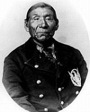
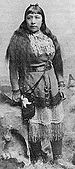
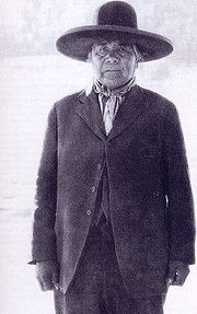
Notable Northern Paiutes
- Nellie CharlieNellie CharlieNellie Charlie was a Mono Lake Paiute - Kucadikadi basketmaker associated with Yosemite National Park. She was born in Lee Vining, California, the daughter of tribal headman Pete Jim, and his wife Patsy, also a basketmaker. She married Young Charlie, a Mono Lake Paiute - Kucadikadi man from...
, basketweaver - EganEgan (Paiute)Egan is the American name given to Pony Blanket. Pony Blanket was a Paiute leader in the Oregon Country in the 19th century.-Early life:Pony Blanket, known to American settlers as Egan, was born to a Cayuse family and did not know his birth mother. He married Evening Star, the sister of Chochoco...
, 19th c. warrior - Chief PaulinaChief PaulinaChief Paulina was a Northern Paiute war leader.During the late 1850s and 1860s, Northern Paiute bands attacked both settler communities and Native American reservations in central and eastern Oregon, as well as the Klamath Basin. Chief Paulina became the most notorious war leader in those raids...
, war leader, d. 1868 - Tau-guTau-guTau-gu was a headman of the Southern Paiutes Native Americans in Arizona in the 1870s.-Notes:...
, late 19th c. chief - Lucy TellesLucy TellesLucy Parker Telles was a Mono Lake Paiute - Kucadikadi and Southern Sierra Miwok Native American basket weaver.-Background:...
, award-winning basketweaver, ca. 1885–1955 - Chief TenayaChief TenayaChief Tenaya was a Native American chief of the Yosemite Valley people in California.-Background:Tenaya's father was the chief of the Ahwahneechee , which means "people of the Ahwahnee" . The Ahwahneechee had become a tribe distinct from the other tribes in the area...
, leader of the Ahwahnees - TruckeeTruckee (chief)Truckee was medicine chief of the Northern Paiute and an influential prophet.-Family life:...
, 17th/18th c. medicine chief - WahvevehWahvevehChief Wahveveh, also spelled Wewawewa was a Northern Paiute warrior and half-brother of Chief Paulina.During the raids of the 1860s in Central Oregon, Wahveveh aided his brother in attacks on the Warm Springs Chief, Poustaminie. His tribe, the Tyghs were attacked by Wahveveh's band while they were...
, war chief, d. 1866 - Chief WinnemuccaChief WinnemuccaWinnemucca, , was born a Shoshoni around 1820 in what would later become the Oregon Territory. He married a Kuyuidika woman, the daughter of Old Winnemucca, and thus was a Paiute himself by tribal rules...
, d. 1882 - Sarah WinnemuccaSarah WinnemuccaSarah Winnemucca was a prominent female Native American activist and educator, and an influential figure in the United States' nineteenth-century Indian policies...
, ca. 1841-1891 - WovokaWovokaWovoka , also known as Jack Wilson, was the Northern Paiute religious leader who founded the Ghost Dance movement. Wovoka means "cutter" or "wood cutter" in the Northern Paiute language.-Biography:...
, prophet and founder of the Ghost DanceGhost DanceThe Ghost Dance was a new religious movement which was incorporated into numerous Native American belief systems. The traditional ritual used in the Ghost Dance, the circle dance, has been used by many Native Americans since prehistoric times...
Population
Estimates for the pre-contact populations of most native groups in California have varied substantially. Alfred L. KroeberAlfred L. Kroeber
Alfred Louis Kroeber was an American anthropologist. He was the first professor appointed to the Department of Anthropology at the University of California, Berkeley, and played an integral role in the early days of its Museum of Anthropology, where he served as director from 1909 through...
thought that the 1770 population of the Northern Paiute within California was 500. He estimated their population in 1910 as 300. Others put the total Northern Paiute population in 1859 at about 6,000.
Owens Valley Paiute
Owens Valley Paiute live on the California-Nevada border, near the Owens River
Owens River
The Owens River is a river in southeastern California in the United States, approximately long. It drains into and through the Owens Valley, an arid basin between the eastern slope of the Sierra Nevada and the western faces of the Inyo and White Mountains. The river terminates at Owens Lake, but...
on the eastern side of the southern Sierra Nevada Mountains in the Owens Valley
Owens Valley
Owens Valley is the arid valley of the Owens River in eastern California in the United States, to the east of the Sierra Nevada and west of the White Mountains and Inyo Mountains on the west edge of the Great Basin section...
and speak the Mono language
Mono language (Native American)
Mono is a Native American language of the Numic group of Uto-Aztecan languages, the ancestral language of the Mono people. Mono consists of two dialects, Eastern and Western. The name "Monachi" is commonly used in reference to Western Mono and "Owens Valley Paiute" in reference to Eastern Mono....
. Their self-designation is Numa, meaning ‘People’ or Nün‘wa Paya Hup Ca’a‘ Otuu’mu - ‘Coyotes children living in the water ditch’
Owens Valley Paiute tribes
- Big Pine Band of Owens Valley Paiute Shoshone Indians of the Big Pine ReservationBig Pine Band of Owens Valley Paiute Shoshone Indians of the Big Pine ReservationThe Big Pine Band of Owens Valley Paiute Shoshone Indians of the Big Pine Reservation are a federally recognized tribe of Mono and Timbisha Indians in California.The Big Pine Reservation is located from Bishop, at the eastern base of the Sierra Nevada...
, Big Pine, CaliforniaBig Pine, CaliforniaBig Pine is a census-designated place in Inyo County, California, United States. Big Pine is located south-southeast of Bishop, at an elevation of 3990 feet . The population was 1,756 at the 2010 census, up from 1,350 at the 2000 census... - Bridgeport Paiute Indian Colony of CaliforniaBridgeport Paiute Indian Colony of CaliforniaThe Bridgeport Paiute Indian Colony of California is a federally recognized tribe of Northern Paiute Indians in Mono County, California.-Reservation:...
, Bridgeport, CaliforniaBridgeport, CaliforniaBridgeport is a census-designated place that is the county seat of Mono County, California. It lies at an elevation of 6463 feet in the middle of the Bridgeport Valley. Bridgeport is located at the intersection of highways US 395 and State Route 182. The population was 575 at the 2010... - Fort Independence Indian Community of Paiute Indians of the Fort Independence Reservation, Independence, CaliforniaIndependence, CaliforniaIndependence is the county seat of Inyo County, California. Independence is located south-southeast of Bishop, at an elevation of 3930 feet . The population of this census-designated place was 669 at the 2010 census, up from 574 at the 2000 census....
- Paiute-Shoshone Indians of the Lone Pine Community of the Lone Pine ReservationPaiute-Shoshone Indians of the Lone Pine Community of the Lone Pine ReservationThe Paiute-Shoshone Indians of the Lone Pine Community of the Lone Pine Reservation is a federally recognized tribe of Mono and Timbisha Native American Indians near Lone Pine in Inyo County, California...
, Lone Pine, CaliforniaLone Pine, CaliforniaLone Pine is a census-designated place in Inyo County, California, United States. Lone Pine is located south-southeast of Independence, at an elevation of 3727 feet . The population was 2,035 at the 2010 census, up from 1,655 at the 2000 census. The town is located in the Owens Valley, near the... - Paiute-Shoshone Indians of the Bishop Community of the Bishop ColonyPaiute-Shoshone Indians of the Bishop Community of the Bishop ColonyThe Paiute-Shoshone Indians of the Bishop Community of the Bishop Colony is a federally recognized tribe of Mono and Timbisha Indians of the Owens Valley, in Inyo County of eastern California.-Reservation:...
, Bishop, CaliforniaBishop, CaliforniaBishop is a city in Inyo County, California, United States. Though Bishop is the only city and the largest populated place in Inyo County, the county seat is Independence. Bishop is located near the northern end of the Owens Valley, at an elevation of 4147 feet . The population was 3,879 at the... - Utu Utu Gwaitu Paiute Tribe of the Benton Paiute ReservationUtu Utu Gwaitu Paiute Tribe of the Benton Paiute ReservationThe Utu Utu Gwaitu Paiute Tribe of the Benton Paiute Reservation, also known as the Benton Paiute Tribe, is a federally recognized Great Basin tribe in Mono County, California.-Reservation:...
, Benton, CaliforniaBenton, CaliforniaBenton is a census-designated place in Mono County, California, United States. It is located 3 miles east-northeast of the community of Benton Hot Springs and north of the community of Bishop, at an elevation of 5387 feet...
Southern Paiute
Colorado River
The Colorado River , is a river in the Southwestern United States and northwestern Mexico, approximately long, draining a part of the arid regions on the western slope of the Rocky Mountains. The watershed of the Colorado River covers in parts of seven U.S. states and two Mexican states...
basin and Mojave Desert
Mojave Desert
The Mojave Desert occupies a significant portion of southeastern California and smaller parts of central California, southern Nevada, southwestern Utah and northwestern Arizona, in the United States...
in northern Arizona
Arizona
Arizona ; is a state located in the southwestern region of the United States. It is also part of the western United States and the mountain west. The capital and largest city is Phoenix...
and southeastern California including Owens Valley
Owens Valley
Owens Valley is the arid valley of the Owens River in eastern California in the United States, to the east of the Sierra Nevada and west of the White Mountains and Inyo Mountains on the west edge of the Great Basin section...
, southern Nevada and southern Utah. Terminated
Indian termination policy
Indian termination was the policy of the United States from the mid-1940s to the mid-1960s. The belief was that Native Americans would be better off if assimilated as individuals into mainstream American society. To that end, Congress proposed to end the special relationship between tribes and the...
as a tribe in 1954 under federal efforts at assimilation, the Southern Paiute regained federal recognition in 1980. Many of these Paiute traded with coastal tribes; for example, tribes of the Owens Valley have been proven to trade with the Chumash of the Central Coast
Central Coast of California
The Central Coast is an area of California, United States, roughly spanning the area between the Monterey Bay and Point Conception. It extends through Santa Cruz County, San Benito County, Monterey County, San Luis Obispo County, and Santa Barbara County...
, based upon archaeological recovery at Morro Creek
Morro Creek
Morro Creek is a coastal stream in San Luis Obispo County, California, USA. This watercourse discharges to the Pacific Ocean at the city of Morro Bay.-Natural history:...
. A band of Southern Paiute at Willow Springs and Navajo Mountain
Navajo Mountain
Navajo Mountain is a peak in San Juan County, Utah, with its southern flank extending into Coconino County, Arizona. It holds an important place in the traditions of three local Native American tribes.-Geologic history:...
, south of the Grand Canyon
Grand Canyon
The Grand Canyon is a steep-sided canyon carved by the Colorado River in the United States in the state of Arizona. It is largely contained within the Grand Canyon National Park, the 15th national park in the United States...
, reside inside the Navajo Indian Reservation. These "San Juan Paiute" were officially recognized as a separate tribe by the Bureau of Indian Affairs
Bureau of Indian Affairs
The Bureau of Indian Affairs is an agency of the federal government of the United States within the US Department of the Interior. It is responsible for the administration and management of of land held in trust by the United States for Native Americans in the United States, Native American...
in 1980.
The first European contact with the Southern Paiute occurred in 1776, when fathers Silvestre Vélez de Escalante and Francisco Atanasio Domínguez encountered them during an attempt to find an overland route to the missions of California
Spanish missions in California
The Spanish missions in California comprise a series of religious and military outposts established by Spanish Catholics of the Franciscan Order between 1769 and 1823 to spread the Christian faith among the local Native Americans. The missions represented the first major effort by Europeans to...
. Before this date, the Southern Paiute suffered slave raids by the Navajo
Navajo people
The Navajo of the Southwestern United States are the largest single federally recognized tribe of the United States of America. The Navajo Nation has 300,048 enrolled tribal members. The Navajo Nation constitutes an independent governmental body which manages the Navajo Indian reservation in the...
and the Ute
Ute Tribe
The Ute are an American Indian people now living primarily in Utah and Colorado. There are three Ute tribal reservations: Uintah-Ouray in northeastern Utah ; Southern Ute in Colorado ; and Ute Mountain which primarily lies in Colorado, but extends to Utah and New Mexico . The name of the state of...
. The arrival of Spanish and later Euro-american explorers into their territory increased slave raiding by other tribes. In 1851, Mormon
Mormon
The term Mormon most commonly denotes an adherent, practitioner, follower, or constituent of Mormonism, which is the largest branch of the Latter Day Saint movement in restorationist Christianity...
settlers strategically occupied Paiute water sources, which created a dependency relationship. But, the presence of Mormon settlers soon ended the slave raids, and relations between the Paiutes and the Mormons were basically peaceful. The Mormon missionary
Missionary
A missionary is a member of a religious group sent into an area to do evangelism or ministries of service, such as education, literacy, social justice, health care and economic development. The word "mission" originates from 1598 when the Jesuits sent members abroad, derived from the Latin...
Jacob Hamblin
Jacob Hamblin
Jacob Vernon Hamblin was a Western pioneer, Mormon missionary, and diplomat to various Native American Tribes of the Southwest and Great Basin. During his life, he helped settle large areas of southern Utah and northern Arizona where he was seen as an honest broker between Mormon settlers and the...
worked at diplomatic efforts. The introduction of European settlers and agricultural practices (most especially large herds of cattle
Cattle
Cattle are the most common type of large domesticated ungulates. They are a prominent modern member of the subfamily Bovinae, are the most widespread species of the genus Bos, and are most commonly classified collectively as Bos primigenius...
) made it difficult for the Southern Paiute to continue their traditional lifestyle, as it drove away the game and reduced their ability to hunt, as well as to gather natural foods.
Today Southern Paiute communities are located at Las Vegas
Las Vegas, Nevada
Las Vegas is the most populous city in the U.S. state of Nevada and is also the county seat of Clark County, Nevada. Las Vegas is an internationally renowned major resort city for gambling, shopping, and fine dining. The city bills itself as The Entertainment Capital of the World, and is famous...
, Pahrump
Pahrump, Nevada
-Demographics:As of the census of 2000, there were 24,631 people, 10,153 households, and 7,127 families residing in the CDP. The population density was 82.7 people per square mile . There were 11,651 housing units at an average density of 39.1 per square mile...
, and Moapa
Moapa Town, Nevada
Moapa Town is a census-designated place in Clark County, Nevada, United States. The population was 928 at the 2000 census. It is the largest town in Clark County by land area...
, in Nevada
Nevada
Nevada is a state in the western, mountain west, and southwestern regions of the United States. With an area of and a population of about 2.7 million, it is the 7th-largest and 35th-most populous state. Over two-thirds of Nevada's people live in the Las Vegas metropolitan area, which contains its...
; Cedar City
Cedar City, Utah
As of the census of 2000, there were 20,527 people, 6,486 households, and 4,682 families residing in the city. The population density was 1,021.8 people per square mile . There were 7,109 housing units at an average density of 353.9 per square mile...
, Kanosh
Kanosh, Utah
Kanosh is a town in Millard County, Utah, United States. The population was 485 at the 2000 census.- Geography :Kanosh is located at ....
, Koosharem
Koosharem, Utah
Koosharem is a town in Sevier County, Utah, United States. The town's name is said to come from either an edible tuber, a traditional staple food for the area's Native Americans, or a Native American name for red clover. The population was 276 at the 2000 census...
, Shivwits, and Indian Peaks, in Utah
Utah
Utah is a state in the Western United States. It was the 45th state to join the Union, on January 4, 1896. Approximately 80% of Utah's 2,763,885 people live along the Wasatch Front, centering on Salt Lake City. This leaves vast expanses of the state nearly uninhabited, making the population the...
; at Kaibab
Kaibab, Arizona
Kaibab is a census-designated place in Coconino and Mohave counties in the U.S. state of Arizona. The population was 275 at the 2000 census.-Geography:Kaibab is located at ....
and Willow Springs, in Arizona
Arizona
Arizona ; is a state located in the southwestern region of the United States. It is also part of the western United States and the mountain west. The capital and largest city is Phoenix...
; Death Valley
Death Valley
Death Valley is a desert valley located in Eastern California. Situated within the Mojave Desert, it features the lowest, driest, and hottest locations in North America. Badwater, a basin located in Death Valley, is the specific location of the lowest elevation in North America at 282 feet below...
and at the Chemehuevi Indian Reservation and on the Colorado River Indian Reservation
Colorado River Indian Reservation
The Colorado River Indian Reservation is 189 miles west of Phoenix, Arizona, on highway 95. It lies in western La Paz County, Arizona, southeastern San Bernardino County, California, and northeastern Riverside County, California. It has a total land area of 432.22 sq mi , and most of it lies...
in California
California
California is a state located on the West Coast of the United States. It is by far the most populous U.S. state, and the third-largest by land area...
. Some would include the 29 Palms
Twentynine Palms, California
Twentynine Palms is a city in San Bernardino County, California, United States. It was previously called Twenty-Nine Palms...
Reservation in Riverside County
Riverside County, California
Riverside County is a county in the U.S. state of California. One of 58 California counties, it covers in the southern part of the state, and stretches from Orange County to the Colorado River, which forms the state border with Arizona. The county derives its name from the city of Riverside,...
, California
California
California is a state located on the West Coast of the United States. It is by far the most populous U.S. state, and the third-largest by land area...
.
Traditional Southern Paiute bands
- Antarianunts (Yantar
ii), historically from near Henry MountainsHenry MountainsThe Henry Mountains are located in the southeastern portion of the U.S. state of Utah and run in a generally north-south direction, extending over a distance of about 30 miles . They were named by John Wesley Powell in honour of Joseph Henry, the first secretary of the Smithsonian Institution. The...
, Utah - Beaver band (Kwi?umpací
ii, Kwiumpus, Quiumputs), "Frasera speciosaFrasera speciosaFrasera speciosa is a species of flowering plant in the gentian family known by the common names monument plant, elkweed, and deer's ears. It is native to the western United States, where it grows in mountain forests, woodlands, and meadows. the northwestern United States, where it grows in open...
people," from near Beaver, UtahBeaver, UtahBeaver is a city in Beaver County, Utah, United States. The population was 2,454 at the 2000 census. It is the county seat of Beaver County.Settled by Mormon pioneers in 1856, Beaver was one of a string of Mormon settlements extending the length of Utah... - Cedar band (Ankappanukkic
icimi), Unkapanukuints, "Red-stream people," from near Cedar City, UtahCedar City, UtahAs of the census of 2000, there were 20,527 people, 6,486 households, and 4,682 families residing in the city. The population density was 1,021.8 people per square mile . There were 7,109 housing units at an average density of 353.9 per square mile... - ChemehueviChemehueviThe Chemehuevi are a federally recognized Native American tribe enrolled in the Chemehuevi Indian Tribe of the Chemehuevi Reservation. They are the southernmost branch of Paiutes.-Reservation:...
(Camowév, Acimuev), "those who do something with fish," now often viewed as a distinct group- Howaits (Hokwaits, lived in the Ivanpah MountainsIvanpah MountainsThe Ivanpah Mountains are located in the southeastern Mojave Desert of California in the United States. The range lies to the south and east of the Mescal Range and west of the Ivanpah Valley and New York Mountains. The mountains lie in a southwest-northeasterly direction, and are home to the...
, called Ivanpah Mountain Group) - Kauyaichits (lived in the area of Ash Meadows, called Ash Meadows Group)
- Mokwats (lived in the Kingston Mountains, called Kingston Mountain Group)
- Moviats (Movweats, lived on Cottonwood Island, called Cottonwood Island Group)
- Palonies ( "the bald-headed.", traveled to the area north of Los AngelesLos ÁngelesLos Ángeles is the capital of the province of Biobío, in the commune of the same name, in Region VIII , in the center-south of Chile. It is located between the Laja and Biobío rivers. The population is 123,445 inhabitants...
) - Shivawach (one group of them lived at Twentynine Palms, the second one in Chemehuevi Valley)
- Tümplsagavatsits (Timpashauwagotsits, lived in the Providence Mountains, therefore called Providence Mountain Group)
- Yagats (lived in the Amargosa ValleyAmargosa ValleyThe Amargosa Valley is a Nevada landform east of the Amargosa Range that is the eponym for the town of Amargosa Valley, Nevada. The Tonopah and Tidewater Railroad ran through the valley from 1906 to 1940.-Solar thermal plant:...
and along the Amargosa RiverAmargosa RiverThe Amargosa River is an intermittent waterway, long, in southern Nevada and eastern California in the United States. It drains a high desert region, the Amargosa Valley in the Amargosa Desert northwest of Las Vegas, into the Mojave Desert, and finally into Death Valley where it disappears into...
, called Amargosa River Group)
- Howaits (Hokwaits, lived in the Ivanpah Mountains
- Gunlock band (Matooshats, Matissatï), from near Gunlock, UtahGunlock, UtahGunlock is an unincorporated community in western Washington County, Utah, United States, north of Gunlock State Park. It lies along local roads northwest of the city of St. George, the county seat of Washington County. Its elevation is 3,658 feet...
- Kaibab (Kaipapic
icimi, Kaivavwits, Kaibabits) named for the Kaibab Plateau in northern Arizona - Indian Peak Band
- Kaiparowits (Escanlante band), named for the Kaiparowits Plateau in Utah
- Las Vegas band (N
ipakanticimi, Nuaguntits), "People of Charles Peak" - MoapaMoapa-Places:* Moapa River Indian Reservation, an Indian Reservation in Southern Nevada that is home to some members of the Southern Paiute* Moapa Town, Nevada, a small community of Southern Nevada...
(Moapats), "Muddy Creek Paiute" - Pahranagat (Pata?nikic
i), "Person who sticks his feet in the water, named for the Pahranagat ValleyPahranagat ValleyThe Pahranagat Valley is a Tonopah Basin landform in Lincoln County, Nevada.The more fertile part of Pahranagat Valley is a narrow ribbon of green like an oasis in the vast Nevada desert...
, Nevada - Panaca (Tsouwaraits, Matisabits), named for Panaca, NevadaPanaca, NevadaPanaca is a town in eastern Lincoln County, Nevada, on State Route 319, about 1 mile east of U.S. Route 93, near the border with Utah. Its elevation is 4,729 feet .-History:...
- Panguitch (Pakiucimi), "fish people," named for Panguitch, UtahPanguitch, UtahPanguitch is a city in and the county seat of Garfield County, Utah, United States. The population was 1,623 at the 2000 census.-Geography:Panguitch is located at ....
- San Juan band (Kwaiantikowkets), "People being over on the opposite side," from the San Juan River in northern Arizona
- Shivwits (Sipicimi, Shebits, Sübüts), "People who live in the East"
- Uinkaret (Yipinkat
iticimi), "People of Mount Trumbull" - Uainuints (Uenuwunts, St. George band), from Saint George, Utah
Contemporary Southern Paiute federally recognized tribes
- Kaibab Band of Paiute Indians of the Kaibab Indian Reservation, Arizona – Kaibab Indian ReservationKaibab Indian ReservationThe Kaibab Indian Reservation the home of the Kaibab Band of Paiute Indians, a federally recognized tribe of Southern Paiutes. The Indian reservation is located in northern part of the U.S. state of Arizona. It covers a land area of 188.75 square miles in northeastern Mohave County and...
, ArizonaArizonaArizona ; is a state located in the southwestern region of the United States. It is also part of the western United States and the mountain west. The capital and largest city is Phoenix... - Las Vegas Tribe of Paiute Indians of the Las Vegas Indian ColonyLas Vegas Tribe of Paiute Indians of the Las Vegas Indian ColonyThe Las Vegas Tribe of Paiute Indians of the Las Vegas Indian Colony is a federally recognized tribe of Southern Paiute Indians in southern Nevada.-Reservation:...
– Las Vegas, NevadaLas Vegas, NevadaLas Vegas is the most populous city in the U.S. state of Nevada and is also the county seat of Clark County, Nevada. Las Vegas is an internationally renowned major resort city for gambling, shopping, and fine dining. The city bills itself as The Entertainment Capital of the World, and is famous... - Moapa Band of Paiute Indians of the Moapa River Indian Reservation – Moapa River Indian ReservationMoapa River Indian ReservationMoapa River Indian Reservation is an Indian reservation located northeast of Las Vegas, near Moapa. It is the land-base for the Moapa Band of Paiute Indians, a local band of Southern Paiute Indians. Moapa River Indian Reservation consists of 71,954 acres .As of the year 2000, the population was 206...
, Moapa, Nevada - Paiute Indian Tribe of UtahPaiute Indian Tribe of UtahThe Paiute Indian Tribe of Utah is a federally recognized tribe of Southern Paiute and Ute Indians in southwestern Utah.-Reservation:The Paiute Indian Tribe of Utah has a reservation composed of ten separate parcels of land, located in four counties in southwestern Utah.-History:Two Ute bands were...
– Cedar City, UtahCedar City, UtahAs of the census of 2000, there were 20,527 people, 6,486 households, and 4,682 families residing in the city. The population density was 1,021.8 people per square mile . There were 7,109 housing units at an average density of 353.9 per square mile...
- Cedar City Band of Paiutes
- Kanosh Band of Paiutes
- Koosharem Band of Paiutes
- Indian Peaks Band of Paiutes
- Shivwits Band of Paiutes
- San Juan Southern Paiute Tribe of ArizonaSan Juan Southern Paiute Tribe of ArizonaThe San Juan Southern Paiute Tribe of Arizona is a federally recognized tribe of Southern Paiute Indians in Coconino County, Arizona.-History:...
– Tuba City, ArizonaTuba City, ArizonaTuba City is a census-designated place in Coconino County, Arizona, United States. The population was 8,225 at the 2000 census. It is the Dine' Nation's largest community, slightly larger than Shiprock, New Mexico. The Hopi town of Moenkopi lies directly to its southeast.The name of the town...
Pah Ute War
The Pah Ute War, also known as the Paiute War, was a minor series of raids and ambushes initiated by the Paiute and which had an effect on the development of the Pony ExpressPony Express
The Pony Express was a fast mail service crossing the Great Plains, the Rocky Mountains, and the High Sierra from St. Joseph, Missouri, to Sacramento, California, from April 3, 1860 to October 1861...
. It took place from May through June 1860, though sporadic violence continued for a period afterward.
See also
- :Category:Native American history
- :Category:Native American history of California
- Coso Rock Art DistrictCoso Rock Art DistrictCoso Rock Art District, containing the Big and Little Petroglyph Canyons, is a rock art site containing over 20,000 of Paleo-Indian and/or Native American Petroglyphs The Coso Range is between the Sierra Nevada and the Argus Range. Indian Wells Valley lies to the south of this location...
- Hetch Hetchy ValleyHetch Hetchy ValleyHetch Hetchy Valley is a glacial valley in Yosemite National Park in California. It is currently completely flooded by O'Shaughnessy Dam, forming the Hetch Hetchy Reservoir. The Tuolumne River fills the reservoir. Upstream from the valley lies the Grand Canyon of the Tuolumne. The reservoir...
- History of the Yosemite areaHistory of the Yosemite areaFor over 3,000 years Sierra Miwok, Mono, Paiute, and other Native American groups have lived in the central Sierra Nevada region of California. When European Americans first visited the area that would later become Yosemite National Park, a band of Miwok-speaking Native Americans called the...
- Mono LakeMono LakeMono Lake is a large, shallow saline lake in Mono County, California, formed at least 760,000 years ago as a terminal lake in a basin that has no outlet to the ocean...
- Mountain Meadows massacreMountain Meadows massacreThe Mountain Meadows massacre was a series of attacks on the Baker–Fancher emigrant wagon train, at Mountain Meadows in southern Utah. The attacks culminated on September 11, 1857 in the mass slaughter of the emigrant party by the Iron County district of the Utah Territorial Militia and some local...
- Northern Paiute traditional narrativesNorthern Paiute traditional narrativesNorthern Paiute traditional narratives include myths, legends, tales, and oral histories preserved by the Northern Paiute people of the Great Basin deserts of western Nevada, eastern California, and southeastern Oregon....
- Pipe Spring National MonumentPipe Spring National MonumentPipe Spring National Monument is located in the U.S. state of Arizona, and is rich with American Indian, early explorer, and Mormon pioneer history...
- Pyramid LakePyramid LakePyramid Lake is the geographic sink of the Truckee River Basin and is located northeast of Reno. The inflow is moderately high silt-loaded surface runoff....
External links
- Burns Paiute Tribe
- Fallon Paiute-Shoshone Tribe
- Removing Classrooms from the Battlefield: Liberty, Paternalism, and the Redemptive Promise of Educational Choice, 2008 BYU Law Review 377 The Piutes and the legacy of Richard Henry Pratt
- Life Among the Piutes: Their Wrongs and Claims
- Paiute Indian Tribe of Utah