

Global storm activity of 2007
Encyclopedia
Global storm activity of 2007 profiles the major worldwide storms, including blizzards, ice storms, and other winter events, from January 1, 2007 to December 31, 2007. Winter storm
s are events in which the dominant varieties of precipitation
are forms that only occur at cold temperature
s, such as snow
or sleet
, or a rainstorm where ground temperatures are cold enough to allow ice
to form (i.e. freezing rain
). It may be marked by strong wind
, thunder
and lightning
(a thunderstorm
), heavy precipitation
, such as ice (ice storm
), or wind transporting some substance through the atmosphere
(as in a dust storm
, snowstorm, hail
storm, etc.). Other major non winter events such as large dust storms, Hurricanes, cyclone
s, tornado
s, gale
s, flooding and rainstorms are also caused by such phenomena to a lesser or greater existent.
Very rarely, they may form in summer, though it would have to be an abnormally cold summer, such as the summer of 1816
in the Northeast United States of America. In many locations in the Northern Hemisphere, the most powerful winter storms usually occur in March and, in regions where temperatures are cold enough, April.
conditions across the Canadian Prairies. Snowfall locally reached between 8 inches (20 cm) to 1 foot (30 cm) in parts of Alberta
, Saskatchewan
and Manitoba
. Particularly hard-hit was central Saskatchewan, including the city of Saskatoon
. The storm was accompanied by strong gusty winds in excess of 40 mph (64 km/h). Two people were killed during the blizzard when their car was stuck near a First Nations
reserve in Saskatchewan
. Saskatoon's Diefenbaker Airport as well as schools were closed.
Prior of hitting the Prairies, the system brought another windstorm to western British Columbia
, with gusts exceeding 60 mph (100 km/h). Additional trees at Vancouver
's Stanley Park
were uprooted. It also hindered efforts from workers who were trying to repair the inflatable roof of BC Place Stadium
(home to the Canadian Football League
's BC Lions
), which was damaged by winds from a previous storm a few days earlier. A secondary wave following the main storm dumped over 4 inches of snow (10 cm) in the Victoria
, Vancouver
, and Seattle areas with heavier snow in the mountains. Over 115,000 homes were without power during the storm in B.C.
The storm would later drop some locally heavy amount of snows in parts of northern Ontario
and central Quebec
with 8 inches (20 cm) reported in Saguenay
.
A cold front sharply drop temperatures from west to east with some areas getting their coldest days of the season across the Canadian and U.S. plains. The cold air later reached the eastern half of the continent at the end of the week.
from the 12th to the 16th causing the deaths of 85 people as of January 20. Several thousands of customers from Texas
to New England
lost power, some for several days. Some areas received as much as 4 inches of ice (100 mm).
Oklahoma
and Missouri
were declared disaster areas as they were the most hard hit states from the storms. Areas from Utah
to New Brunswick
received heavy amounts of snow from the 13th to the 16th. The storm was followed by an intense period of cold across most of the continent from California
to Newfoundland and Labrador
.
Additional waves of precipitation have affected the south half of the United States from the 16th to 18th from Texas to North Carolina
, while another winter storm, called a weather bomb affected portions of New Brunswick, Quebec
and Maine
on the 19th and 20th with near blizzard conditions. Portions of eastern Quebec received as much as 32 inches of snow (80 cm) in just over 12 hours
A total of 85 deaths across 12 U.S. states and three Canadian provinces, and caused hundreds of thousands of residents across the U.S and Canada to lose electric power
.
Most of them were in road traffic accidents, by the series of winter storms; 14 in Missouri
, 8 in Iowa
, 12 in Texas
, 2 in Minnesota
, 4 in New York
, 1 in Maine
, 1 in Indiana
, 4 in Michigan
, 3 in Arkansas
, 1 in Quebec
, 1 in Ontario
, 1 in Nova Scotia
, 2 in North Carolina
, 2 in Kansas
, 4 in Nebraska
and 25 in Oklahoma
. An accident near Elk City, Oklahoma
, killed 7 occupants who were inside a minivan
when it collided with a tractor-trailer during the storm.
Another winter storm affected the central and southern Plains from the 19th to the 21st bringing snow and ice for most of the area with accumulations that topped off at about 4 to 10 inches of snow (10–25 cm). It also brought a light wintry mix across the Ohio Valley and the mid-Atlantic states on the 21st with little accumulation. Newfoundland and Labrador
was the last region affected by the series of storms on the 23rd and 24th.
with hurricane winds which hit the west coast of Sweden
and Norway
on the morning of 14 January 2007. In Sweden six people died from the storm and approx. 300,000 households were left without electricity
. 6 Sweeds died in the storm.
 A major European windstorm
gave heavy amounts of snow across portions of Scotland
. Most areas of western Europe from Great Britain
to the Czech Republic
have experienced damaging winds. Wind gusts have reached 90 mph (150 km/h) in the plain and up to 140 mph (225 km/h) in the mountain area. Boat
, rail
and air traffic have been heavily affected, while several hundreds of flights from London
, Berlin
, Amsterdam
, Vienna
, Prague
and Paris
have been delayed or canceled. U.S. Secretary of State
Condoleezza Rice
shortened her European trip due to the strong winds. Millions of residents were without power including 1 million in the Czech Republic
. As of 9:00 PM GMT on January 21, Kyrill had caused 47 fatalities. They were- 13 in Germany, 11 in United Kingdom, 7 in Ireland, 6 in The Netherlands, 4 in Poland , 3 in the Czech Republic 3, 1 in France, 1in Belgium and 1 in Austria.
Germany had 3 tornadoes on February 22 and
More tornadoes were confirmed from Poland.
, Austria
and Germany bringing locally heavy snow accumulations and ice which disrupted air and train travel in Berlin
, Stuttgart
and London
. Some areas in the Alps
region received as much as 1 meter of snow (40 inches). Three people were killed in Germany
due to accidents caused by the storm. Over 5,000 motorists were stranded in a highway in eastern France
due to the heavy snow amounts. Scattered power outages were reported with central France being affected the most with nearly 85,000 homes without power.
On the 27th abolut 40,000 people had been affected by flooding in Bolivia and Peru
, Georgia
, the Carolinas and Tennessee
with scattered sleet and freezing rain farther south. Anywhere from 1-4 inches of snow fell across Tennessee and Arkansas, with lighter amounts in the Carolinas.
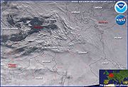
event, titled Lake Storm "Locust", occurred across the Great Lakes
regions for several days. Areas most affected by the localized heavy burst of snows were just east of Georgian Bay
area near Parry Sound
, east of Lake Huron
near Wiarton
, in western Michigan
, and in north central New York
.
Areas near Oswego
and northeast of Syracuse
received as much as 141 inches (358 cm) of snow during that period. There were unofficial reports that two towns on the Tug Hill Plateau
southeast of Lake Ontario
received over 10 feet (305 cm) of snow — Redfield
, with 141 inches (358 cm) and Parish
, with 121 inches (307 cm). Local accumulations elsewhere on the plateau were well over 1 meter (3.3 ft). A state of emergency
was declared in Oswego County
due to the intense snow. Portions of central Ontario received 1–3 feet (30–90 cm) of snow over the period while heavy accumulations were also reported in western Michigan
just off the shores of Lake Michigan
.
On February 1, a snow squall just east of Oshawa
, Ontario
on the north shore of Lake Ontario caused a 15-vehicle pileup including a tractor trailer which burst into flames. Two people were killed in the event. There were no reported deaths related to the event in New York State. However, 20 were killed in other states due to cold weather. The event was very localized; areas outside the narrow bands received little or no snow.
including the City of London
disrupting travel all across the city including numerous flights cancelled from all airports and several motorists were stranding on area roads. Service on the Underground
subway system was also affected with several stations been closed. Many schools were also closed for one or two days. The heavy snowfall started life as a low-pressure system sitting out in the Atlantic Ocean
, at the time the UK was under the influence of a cold northerly wind. The low pressure system tracked towards the UK on the evening of February 7 and turned readily to snow as it hit the cold air. The snow turned back to rain across southern and western regions, but much of Wales, the Midlands and the south-east had significant snowfalls on the 8th. The West Midlands in particular was badly hit, with up to 6 inches (15 cm) reported over high ground – the most snow to fall in this region for 15 years. In Wales
, Sennybridge in Powys
, reported 15 inches (38 cm) on level snow with drifts of up to 3 feet (90 cm) in places. On the 9th, the low pressure over France
tracked further north than forecast, bringing more heavy snow for the Midlands
and Wales. This caused additional travel disruption as the roads were not gritted and heavy gridlock formed on many of the roads. The snow began to thaw over the weekend and in turn caused some localised flooding.
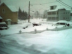 A major winter storm affected a large area of eastern North America from Nebraska to the Canadian Maritimes. Numerous areas received snow accumulations of over 6 inches (15 cm) with isolated reports as much as 1 meter (3.3 ft) in the Adirondacks and the Vermont
mountains. Burlington, Vermont
set a 24-hour snowfall record, with 25.3 inches. Twelve to sixteen inches (30 to 41 cm) of snowfall and blizzard conditions in central Illinois cancelled classes at the University of Illinois at Urbana-Champaign
for two days, the first time classes had been cancelled since 1979.
Large cities including Cleveland
, Hamilton
, Syracuse
, Rochester
, Burlington
, Quebec City
and Sherbrooke received amounts well in excess of 1 foot of snow (30 cm). The city of Hamilton received local snowsqualls bombarding in from Lake Ontario
with a north-east wind which dumped over 2 feet of snow (75 cm) in some parts of the city.
Mixed precipitation fell across the southern Ohio Valley and the Interstate 95
corridor from Virginia
to Boston
, including New York City
, Washington, D.C.
and Philadelphia.
The storm has been blamed for 35 deaths across 13 states and three Canadian provinces.
, the capital of Newfoundland and Labrador
, shutting down most of the city, and closing all area schools. Heavy amounts were reported in the western Avalon Peninsula
of the province. The storm previously affected portions of Nova Scotia
and dumped locally heavy amounts of snow due to sea effects coming from the Atlantic Ocean
and the Bay of Fundy
. A new storm on the 23rd and 24th dumped an additional 6 inches (15 cm)in the capital with freezing rain, while heavier amount fell just to the west.
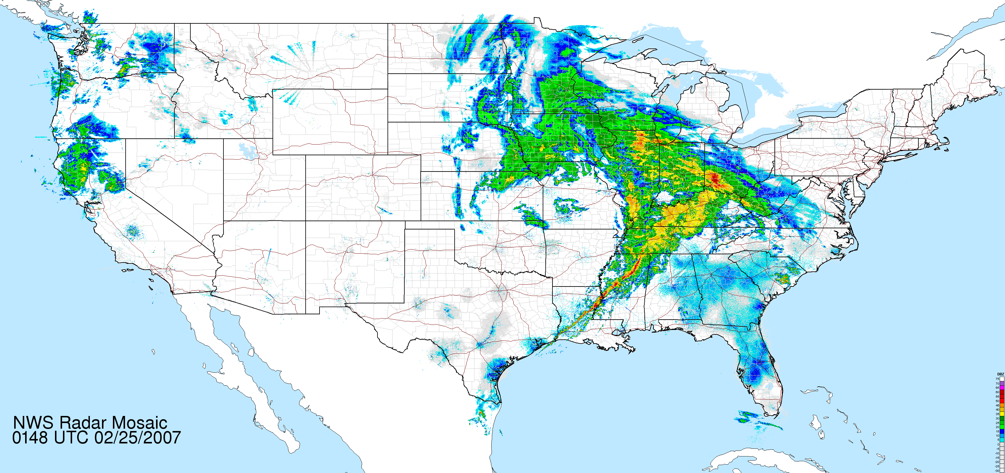 A storm moved onto the northern California
coast early on the 21st, leading to 1–3 feet (30–90 cm) of snow across the southern Cascades, Siskiyous
, Sierra Nevada, and the mountains of southern California. It also gave moderate snowfall accumulations across the Canadian Prairies between 4 and 8 inches (10–20 cm) across Manitoba. The storm then moved east, bringing up to 2 feet (60 cm) to the mountains of Utah
and Colorado
. Late on the 23rd, it moved onto the central High Plains
and organized into a major storm that spread snow from eastern Colorado
northeast into the Upper Midwest
and Great Lakes
region, and ice from Iowa to northern Indiana. The system then split into two with the northern branch dissipating due to a blocking ridge of high pressure which prevented the blizzard from moving north into Canada
. The storm continued into the Mid-Atlantic on the 25th, dropping snow as far south as the Washington, D.C.
area.
Snowfall amounts from 12 to 24 inches (30–60 cm) were common in Minnesota
, Iowa
, Wisconsin
, and Illinois
, while lighter amounts were reported in Michigan
and Ontario
. Winona, Minnesota
recorded the highest official snowfall total in this region, with 29.5 inches (75 cm) as well as La Crosse, Wisconsin
with 21 inches (53 cm). Up to 1.5 inches (38 mm) of ice accumulation was reported from Iowa
eastward into northern Indiana
. Sustained winds of 30–40 mph (48–64 km/h) resulted in severe blowing and drifting in some of these locations. 10 people were killed in traffic accidents during the storm including 8 in Wisconsin, one in Ontario and one in Kansas. A forty car pileup resulted in the closing of Interstate 70 between Denver
and Goodland, Kansas
. This storm caused massive delays and cancellations at Chicago O'Hare and Midway Airport. At one point, 250,000 customers in Iowa were without power. Some people got their power back quickly, for others it took quite a while. The storm then moved into the mid-Atlantic states
, where up to 8 inches accumulated. Blizzard or winter storm warnings were in effect at one point in Kansas, Nebraska, South Dakota, Iowa, Minnesota, Wisconsin, Illinois, Indiana, Michigan, Ohio, Pennsylvania, Maryland, Virginia, West Virginia and Washington, D.C.
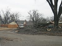
The storm also brought severe thunderstorms and tornadoes from Kansas
to Alabama
, hitting Arkansas
especially hard, where Dumas
was heavily damaged by a tornado.
in northern Europe dumping heavy amounts of snow. The storm was blamed for one fatality in Denmark
,while hundreds of flights from Copenhagen
and Sweden
were cancelled. Numerous motorists were stranded due to drifts that reached locally 3-meters high. A sports hall in Thisted
, Denmark
also collapsed but the building was vacant.
 The 2007 Mozambican flood
began in late December 2006 when the Cahora Bassa
Dam overflowed from heavy rains on Southern Africa
. It worsened in February 2007 when the Zambezi River broke its banks, flooding the surrounding areas in Mozambique
. The Chire and Rivubue rivers have also flooded. Avbout 80,600 were evacuated. Ther were 29 known and 10 unconfirmed deathes in Mozambique
.
coast on the 27th, adding to the several feet of snow already recorded in the Cascades
and Sierra Nevada in the previous few days. It is impacted the Upper Midwest
, the northern Plains, the Great Lakes
and Quebec
regions with heavy snow, sleet, freezing rain and high winds by March 1 and 2, in addition of bringing more severe thunderstorms to the South. Already, numerous tornadoes were reported in Alabama
, Georgia
, Missouri
and Kansas
including six killers. A deadly tornado struck Enterprise High School
, killing 8 students on
March 1. On March 2, over 2 inches of rain fell in New York City
and snow, sleet and freezing rain fell in the interior Northeast.
Omaha, Nebraska
was under a blizzard warning for the first time in 9 years, with much of the city receiving a foot (30.5 cm) or more of snow, and thunder snow as reported at the beginning of the storm. Wind speeds in Omaha were clocked as high as 58 miles per hour, creating snow drifts in outlying areas up to 8 feet depth. The entire state of Iowa was placed under a State of Emergency
by Governor Chet Culver
while large stretches of Interstate 80
were shut down. The National Guard came into the area to bring generators to restore power until utility lines were repaired.
Several areas in Manitoba as well as the Northern Plains received over 8 inches (20 cm) of snow with portions of Wisconsin receiving 16 inches (40 cm), 17 inches (42 cm) for parts of Iowa
, 12–25 inches (30–63 cm) in parts of Minnesota with the highest accumulations falling in the northwest suburbs of the twin cities metropolitan region, (Anoka, Champlin, Maple Grove, Plymouth, Rogers)., and up to 21 inches (53 cm) across the Dakotas. Portions of Ontario and Quebec from Sault Ste. Marie
to Montreal
(including Sudbury, North Bay
and Ottawa
) received between 6 and 10 inches of snow (15–25 cm) on March 2. 80,000 customers lost power in the province with localized heavy amount across the Appalachians. Although Toronto
did not receive large amounts of snow around 10 cm (4 in.), hours of freezing rain that followed created a hazardoussituation the next day when the temperature rose in the city core and under the CN Tower
causing massive chunks of ice sheets to cascade off the buildings hundreds of metres below, breaking some vehicle windows in a hotel parking lot. It forced City police to close the Gardiner Expressway
on March 5.
The storm with the tornadoes and snow was blamed for 39 deaths including 10 in Alabama
, 1 in Missouri
, 9 in Georgia
, two in Manitoba
, two in Ontario
, one in Minnesota
, three in Michigan
, one in Nebraska
, four in North Dakota
, one in Massachusetts
and four in Wisconsin.
and Mongolia
were hit by the worst winter storm in over 50 years. The provinces of Liaoning
and Shenyang
had adopted emergency measures in able to cope with the storm which shut down numerous highways and canceled numerous flights while disrupting train service. Strong winds created snow drifts of up to 2 meters deep.
Rescue ships had to assist a large group of fisherman on the Yellow Sea
following a storm tide. Two people were killed in Tianjin
when a storm surge collapsed several warehouses. As much as 50 cm (20 inches) fell in the province in Heilongjiang
.
's second winter storm of the season shut down most roads, schools and businesses across much of the country due to accumulations exceeding 4 inches (10 cm) including the capital of Amman.
Much of the Middle East usually have little or no snow during the winters due to much warmer conditions caused by the moderate sea effects from the Mediterranean Sea
. However 3 feet (90 cm) of snow fell in a storm 2004, which was the worst since 1950.
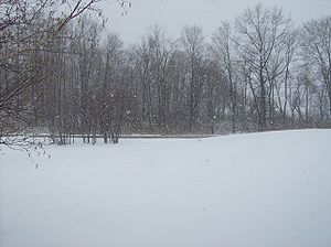
A heavy nor'easter
caused severe Precipitation
that started as rain across the region during the evening of the 15th, but as colder air moved in aloft, precipitation changed quickly to snow in The Poconos
around Midnight EDT on the 16th and in Berks County
and the Lehigh Valley
around 7 a.m. EDT. Farther to the south, the surge of cold air was confined to a more shallower layer and precipitation changed to sleet around the Greater Philadelphia Metropolitan Area between 6 a.m. and 9 a.m. EDT. Precipitation continued as mainly sleet across the greater Philadelphia through the evening. The nor'easter caused heavy sleet to fall across the greater Philadelphia Metropolitan Area, heavy snow and sleet also fell across Berks County, the Lehigh Valley
and heavy snow hit the Poconos on both the 16th into the early morning of the 17th.
The winter storm caused scores of accidents. Various vehicles rolled over, slid off roads, slid into each other, slammed into guardrails and fishtailed. The afternoon and evening commute
slowed to a crawl. In the Greater Philadelphia Metropolitan Area, about 265 schools dismissed early and more than 60 community events were either cancelled or postponed on the 17th. A few schools also closed on the 16th, but most of the others had early dismissals and many after school activities were postponed. Some state offices and county courts also closed early and several municipalities declared snow emergencies over the 16th to 18 March.
The winter storm wreaked havoc at Philadelphia International Airport
had most flights on the 16th cancelled and it took a couple of days for flights to return to normal. The largest impact of the winter storm within Philadelphia was the cancellation of most of the 1,200 scheduled flights at the Philadelphia International Airport. About 1,000 people were stranded at the airport the night of the 16th. Passengers on about 15 U.S. Airways
planes sat on the tarmac for over four hours before gates became available to deplane them. Operations resumed on the 17th, but U.S. Airways still had to cancel about one quarter of its flights because the weather prevented crews and planes from arriving in Philadelphia. About 100 travelers slept at the airport on the night of the 18th. Normal operations resumed on the 19th.
The Pennsylvania Interscholastic Athletic Association
postponed several state playoff high school basketball games. A couple of Saint Patrick's Day
parades scheduled for Saturday the 17th were also postponed on the 16th. The Philadelphia Flyers
hockey team was forced to fly out of Atlantic City International Airport
on the 17th. The horse racing card at Philadelphia Park was also cancelled for three days.
On the 17th snow accumulations averaged 4 to 6 in (10.2 to 15.2 ) in the local Philadelphia area, 5 to 9 in (12.7 to 22.9 ) in Berks County and the Lehigh Valley and 12 to 18 in (30.5 to 45.7 ) in the Poconos.
In Berks County and the Lehigh Valley, the snow mixed with and changed over to sleet during the later afternoon and the first half of the evening before it went back to all snow. Precipitation ended early in the day on the 17th (before 3 a.m. EDT) as mainly snow in all areas. Elsewhere in Bucks County, portions of the Northeast Extension of the Pennsylvania Turnpike
near Quakertown were stalled when two tractor-trailers collided in the southbound lanes at 2 p.m. EDT. A six mile back-up occurred. About 1,900 homes and businesses lost power in Newtown
after a vehicle struck a pole.
The sleet forced the closure of the eastbound lanes of the Vine Expressway within the city for about half an hour between the Schuylkill Expressway
and Interstate 95
for its removal. In Montgomery County
, in Montgomery Township, an accident on Pennsylvania State Route 309
and Taylor Road badly injured one person. In Towamencin Township, two accidents resulted in two injuries occurring.
In Chester County
, the state police reported 46 accidents in the central part of the county, but only one reported injury. A woman was hospitalized after a crash on Pennsylvania State Route 113
in Phoenixville
. Several businesses in the county closed early. In Berks County, in Union Township one vehicle slid off a road and landed upside down in a creek. The driver was treated for non-threatening life injuries. A serious accident occurred on Old U.S. Route 22 in Lenhartsville.
The Lehigh Valley had a number of serious accidents on Interstate 78
. In Lehigh County, a tractor-trailer jack-knifed near Pennsylvania State Route 100
at Fogelsville
and closed the interstate from 330 p.m. EDT through 515 p.m. EDT. Both southbound lanes of the Pennsylvania Turnpike Northeast Extension
were closed from 155 p.m. EDT through 420 p.m. EDT after two tractor-trailers and a car collided in Lower Milford Township. Many flights at the Lehigh Valley International Airport
were delayed, a couple were cancelled.
 Commuter buses bringing workers home from New York City
had long delays. In Northampton County
, a tractor-trailer jackknifed on the eastbound lanes of Interstate 78 about 4 p.m. EDT near the Pennsylvania State Route 33 junction. All lanes were not reopened until 545 p.m. EDT. In Moore Township, a school bus
collided head-on with a car. Both drivers, but no children were injured.
In Lower Mount Bethel Township, a Jeep Cherokee
slid into a home on Pennsylvania State Route 611 and injured the driver. A Ford Explorer
driver was injured after the vehicle struck a tree in Wind Gap
. Problems on Lehigh Valley roadways continued long after the snow and sleet ended. A driver was injured on U.S. Route 22
in Whitehall Township
(Lehigh County) when ice chunks from a tractor-trailer hit their vehicle. In Upper Macungie Township (Lehigh County), ice chunks that flew off a Wal-Mart
tractor-trailer cracked the windshield and dented the hood of a vehicle on Interstate 78
near the Pennsylvania State Route 100's exit.
In the Poconos, many shopping mall
s and sports complex
es closed early. In Monroe County
, a flipped over truck snarled traffic on U.S. Route 209
and Pennsylvania State Route 33. A jack-knifed tractor-trailer on eastbound Interstate 80
near Stroudsburg snarled the evening commute to a crawl.
Snow and sleet depth totals across the north eastern US included 18 inches (45.7 cm) in Albrightsville (Carbon County
) and Effort (Monroe County
), 15.4 inches (39.1 cm) in Lehighton (Carbon County) it was at 14.5 inches (36.8 cm). In Tobyhanna (Monroe County), 14.2 inches (36.1 cm) in East Stroudsburg (Monroe County) it was at 10 inches (25.4 cm). In Slatington
(Lehigh County) it was at 8.5 inches (21.6 cm) in Reading
(Berks County) and at the Lehigh Valley International Airport
it was at 6.5 inches (16.5 cm). In Birdsboro (Berks County) and Springtown (Bucks County) it was at 6.1 inches (15.5 cm).
In Glenmoore (Chester County
) it was 6 inches (15.2 cm). In East Nantmeal (Chester County), 5.7 inches (14.5 cm) in Doylestown
(Bucks County) it was at 5.5 inches (14 cm). In Elkins Park and King Of Prussia
(both Montgomery County
) it was at 5.3 inches (13.5 cm) In Marshalls Creek (Northampton
County) it was at 5 inches (12.7 cm).
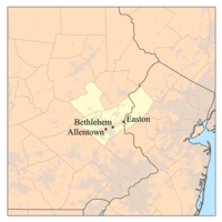
In Broomall (Delaware County
) and Bethlehem
(Northampton County) it was 4.8 inches (12.2 cm). In Roxborough
(Philadelphia County) it was 4 inches (10.2 cm) In Drexel Hill (Delaware County) and Neshaminy Falls (Bucks County) it was 3.8 inches (9.7 cm) In West Chester
(Chester County
) it was 3.1 inches (7.9 cm). In Wynnewood
(Montgomery County
) and at the Philadelphia International Airport
it was 3 inches (7.6 cm).
A strong high pressure system moved across nearby parts of Canada
and supplied a fresh supply of cold air into the region.
Hundreds of traffic accidents occurred across the northeast and Canada
including one involving a vehicle from George W. Bush
's motorcade
in Washington, D.C.
.
The winter storm was caused by a nor'easter
low pressure system that developed on a cold front that moved through the area on the 15th. Prior to that, unseasonably mild air helped push high temperatures as high as the 70s.
Meanwhile, the low pressure system formed over South Carolina
and Georgia
on the morning of the 16th and moved northeast. At 2 p.m. EDT on the 16th, it was near Myrtle Beach, South Carolina
; at 8 p.m. EDT that evening, it was just east of Virginia Beach; at 2 a.m. EDT on the 17th, it was about 100 miles (160.9 km) east of Atlantic City, New Jersey
and was about 100 miles (160.9 km) south of Cape Cod
, Massachusetts
at 8 a.m. EDT on the 17th. As central pressures go, this was not particularly a powerful system; it was only 996 millibars the morning of the 17th. What contributed to the event, was the strong high pressure system (about 1040 millibars the morning of the 16th). It supplied the fresh cold air needed to change the precipitation over to sleet and freezing rain and increased the pressure gradient (and consequently the wind) between itself and the developing nor'easter low pressure system.
The only seriouse reported traffic fatality from the storm in Eastern Pennsylvania occurred in Bucks County. An 18-year-old girl from Plumstead Township was killed when her vehicle crossed the center line of an icy Durham Road and collided with a dump truck on the 16th.
So far, 10 people have been killed by the storm, all in traffic accidents. This includes six in New Jersey
, three in Pennsylvania
and one in Maryland
.
on the 27th and developed into a major winter storm across the northern and central Rockies and northern High Plains. Many of the western valleys, from the Wasatch Front
through the valleys of Wyoming
, onto the Plains of Wyoming and Montana
, saw about 6-12 inches of snow, with 1–2 feet in the mountains from the 27th through the 29th. Up to 3 feet fell in the Wasatch Range
and Bighorn Mountains. The storm was concentrated around south-central Montana and north-central Wyoming, where such cities as Sheridan
and Billings
and surrounding areas could see 1–2 feet of snow. Throughout the mountains and on the Plains (including Saskatchewan and Manitoba), this snow was accompanied by strong winds, leading to localized near-blizzard to blizzard conditions.
 A late season winter storm dumped a large swath of snow from North and South Dakota, eastward through Minnesota, Wisconsin and into Upper Michigan. Up to 9 inches of snow fell near Bismarck, North Dakota
, 11 inches in Brainerd, Minnesota
, and areas near Hurley, Wisconsin
received 18 inches. Parts of Upper and northern Michigan then saw a major Lake Effect event over approximately five days. Painesdale, Michigan
received 65 inches of snow and the National Weather Service in Marquette
received 47 inches, shattering most previous April snowfall records for that city. Lake effect also affected the Lake Erie region http://www.erh.noaa.gov/cle/wx_events/Easter2007/Eastersnow1.PNG, cancelling the series between the Cleveland Indians
and Seattle Mariners
baseball teams in Cleveland
, and prompting a move of the next series with the Los Angeles Angels of Anaheim
from Jacobs Field
to Miller Park in Milwaukee
.
In northern New England, the storm hit on Wednesday afternoon and left behind up to a foot and a half of snow, sleet, and freezing rain. Over 180,000 homes lost power, mostly due to broken tree limbs snapping wires. The storm has caused at least one death.
Heavy snow also fell across much of southern and central Quebec with amounts in excess of 12 inches across some areas with higher amounts over higher terrain in the Charlevoix
region. Numerous accidents were reported across the provinces including one involving a firetruck. Two people were killed in accidents across the province.
On the back side of the storm persistent heavy flurries gave additional accumulations of a few inches across most of Ontario and Quebec.
, Nova Scotia
, Quebec and Prince Edward Island
on Easter
Sunday dumping as much as 12 inches of snow locally along with strong winds which caused flight cancellations at Halifax International Airport
and scattered power outages, mainly in Nova Scotia.
of the United States was affected by a late-season April winter storm. Snowfall totals of 8 inches was reported in Fairmont, Minnesota
while 9 inches was recorded in Victory, Wisconsin
. 6 people died in snowfall related traffic accidents near Green Bay, Wisconsin
. 5.1 inches fell in Muskegon, Michigan
, on April 11, setting a snowfall record for that date.
Heavy mixed precipitations fell across portions of the Canadian Maritimes and southern Quebec with accumulations that exceed 8 inches (20 cm) across the Eastern Townships
and the Beauce
region. The storm did shut down some school across Nova Scotia on the 13th.
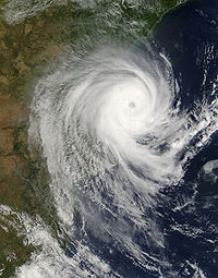
struck the eastern half of North America
bringing heavy rains, floods, storm surges and damaging wind across coastal areas. New York City
itself received nearly 8 inches (200 mm) of rain in one day, making it one of the rainiest days ever for the city. Flooding did occur across many suburbs of the region as well as in other areas of the East Coast from Maine
to Virginia
. In Cape Elizabeth, Maine, an 80 mph wind gust was recorded, along with 30 foot waves that battered the coast. In New York, the National Guard
assisted the emergency procedures while Maine, West Virginia
and New Jersey
declared state of emergencies. Several tornado
es struck the Carolinas killing at least 1 in South Carolina
. Additional tornadoes struck northern Texas
on the 13th.
In addition, heavy snow fell across portions of Colorado
, Kansas
, New Mexico
and Oklahoma
on the 13th, bringing about 12 to 18 inches (30–50 cm) across the higher elevations. Then it dumped heavy snow across the Appalachian Mountains
and the Laurentians
of Quebec on the 15th and 16th. 17 inches (43 cm) fell over portions of Vermont
, as much as 26 inches (65 cm) in Tupper Lake, New York, as much as 40 inches (100 cm) in the Charlevoix
region of Quebec while 4 to 6.5 (10–16 cm) inches also blanketed the cities of Montreal
and Ottawa
and the surrounding regions in just a few hours.
In Quebec
as much as 160 000 Hydro-Québec
customers lost power from the Outaouais to the Quebec City
region while several schools were closed north of Montreal. An additional 17 000 households serviced by Hydro One
and Hydro Ottawa
suffered power outage
s in Eastern Ontario
In the U.S over 300,000 customers lost power from Maryland
to Maine
including 55 000 in New York, 50 000 in Pennsylvania
, 43 000 in Connecticut
, 46 000 in New Hampshire
, 17 000 in Maine, 30 000 in Maryland, 25 000 in Vermont and 12 000 in Massachusetts
.
Numerous flights were delayed or canceled from New York
, Boston
and Philadelphia
as well as the Canadian airports of Montreal
, Ottawa
and Quebec City
. In Boston
, the annual Boston Marathon
when ahead of schedule despite howling winds and pouring rain as well as cold temperatures.
Three people were killed in South Carolina, five in total in Texas and Kansas
and five in Quebec.
including the higher elevations of Colorado
. Areas west of Denver received a much as 26 inches of snow (near Evergreen
) with several other reports of 12 inches or more. while severe weather affected eastern portions of the state.
received heavy rain and damaging tornadoes
, regions in higher elevations across the Rockies
, including Colorado
, Wyoming
, Utah
, Nebraska
and Idaho
, received snow, locally a major winter storm. Portions of central and northern Colorado received as much as 12 inches (30 cm) of snow during the overnight event.
destroying the town and killing 14 people.
om May 15 and 16, causing heavy flooding in the south and east of the country. 8 inches of rain also fell in Gdansk
causing heavy localised flooding until the 17th.
On Sunday, May 16, the rivers in Malopolska had reached alarming leavels in 6 locations, a state of flood alert was issued in 23 places. Flood alerts have been announced in the communities Liszki
, Skawina
, Cracow, Rzezawa
, Łapanów, Bochnia
, Borzęcin Gnojnik, Brest-Litovsk, Bobowa
and Gorlice
.
along with some other parts of the Lublin
area as the river Vistula
broke it’s banks. Most people do not want to leave their homes and were focibly removed for their own safety. The river Wisła fell by 12 cm of rain fell in Sandomierz
, but the level of water grew alarmingly in the Lublin
, Liszki
and Lodz
. A person was killed in Lubin as he fell in to a flood swoled streem near their home.
May 22 saw Warszawa’s opera hall, some schools, kindergartens and babies’ nurseries
were closed in areas at risk of flooding. Local and state officials also asked for the expertise of German specialists who are experienced in carrying out the mass evacuation. Several hectares of land in the commune of Wilków was flooded by the Vistula
River. Wroclaw
was partly flooded as the river Oder
broke a dyke and the district Kozanów flooding an area of about 80 hectares.
, Liszki
and Lubin
as more powerful storms have passed over many places in the country and brought heavy rainfall. Most dykes and levees had been upgraded mostly held out in the Lublin
area . The governor
of Mazovia
, Jacek Kozlowski, introduced a flood alert for all the municipalities and counties south of Mazovia
.
Between June 3 and 4 dangerous levels of flooding returned to Lower Silesia
. Local officials declared flood emergency in 16 counties and the city of Legnica
The Polish Hydrological Service also confirmed that the river Oder
would probably be involved in the second wave of climactic flooding.
had closed the locks in the drainage ditches as flooding occurred several settlements in the municipality of Wierzchosławice. In the municipality Gromnik a series of landslides occurred , with some threateningly the high voltage poorer lines in Ryglice
.
Premier Donald Tusk
visited a flooded village as the water began to subside .
and Chile
creating hazardous traveling through several areas. Hardest hit areas were in the higher elevation along the Chile and Argentina borders. One of the main roads connecting the two counties was fully shut down while numerous trucks were left stranded in the area. The combination of heavy snow and hurricane-force winds force the shutdown of schools and businesses in Bariloche
a popular resort destination in the country. Accumulations of several meters of snow fell in the Cristo Redentor Tunnel mountain pass.
and South Island, New Zealand. Heavy snows fell in the mountain regions of the Blue Mountains west of Sydney as well as Oberon
and Bathurst
while it disrupted air travel in Otago, New Zealand while causing numerous accidents across the area due to slippery conditions.
weather station reported winds gusting up to 90 mi/h on the evening of July 1, and winds up to 110 mi/h by July 3. The strong winds caused temperatures to drop to -10 °F and did not rise until July 4. Other weather stations in the Antarctic Peninsula
reported similar effects.
during the July 6, 7 and 8 of 2007, and the entry of a massive polar cold snap
made as a result the worst winter of Argentina in almost forty years, where severe snowfalls and blizzard
s affected the country The cold snap advanced from the south towards the central zone of the country during Friday, July 6, continuing its displacement towards the north during Saturday, July 7 and Sunday, July 8. On Monday July 9, the simultaneous presence of very cold air, above the average levels of the atmosphere
as in the surface, gave place to the occurrence of snowfalls even in localities where snow is rare. This phenomenon left at least 23 people dead.
It was the third time that a phenomenon like this happened in the country. The first time was in 1912 and the second one was in 1918, occasion in which even there was major volume of snow.
is flooded by heavy rain. The flooded area included the bus and railway station.
to be one of the worst floodings in recorded history. The flooding started with rains on September 14, 2007 and lasted for 3 days. 14 countries had been affected in the continent of Africa
, 250 people were reported to have been killed by the flooding and 2,500,000 were affected. The UN had issued warnings of water borne diseases and locust infestations.
In Ghana
400,000 were homeless with at least 20 people dead and crops and livestock had been washed away over the 3 day event.
George Azi Amoo - Ghana's national disaster management co-ordinator
64 people were reported killed in the Sudan
. 17 people were reported dead Ethiopia
. In the Afar Region
, the Awash River
flooded caused a dam to collapse. Around 4,500 people were stranded, surrounded by water. 150,000 people were displaced in Uganda
and 21 reported dead. 170 schools were under water. 18 people were reported dead and 500 residences were washed away by floods in Rwanda
. Mali
saw 5 bridges had collapsed and 250 residences were washed away. 33 people were reported dead in Burkina Faso
, 12 people were reported dead in Kenya
and Togo
reported that 20 people were reported dead
 Hurricane Noel
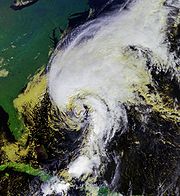
, which killed 163 people in the Caribbean Islands, affected most of Atlantic Canada
, eastern Quebec
and eastern New England
as a post-tropical system with heavy rains and damaging winds in excess of 100 km/h (60 mph). The highest gust was recorded in the Wreckhouse
area in Newfoundland and Labrador
where gusts reached 180 km/h (110 mph). Nearly 200,000 customers in Atlantic Canada alone lost power during the height of the storm. In the northwestern most edge of the system, Noel produced a narrow swath of snow (thus the first major winter storm across those areas) which affected areas of Maine, as well as Happy Valley – Goose Bay, Newfoundland and Labrador
and eastern Quebec from near Rivière-du-Loup to Sept-Îles
including Rimouski, Amqui, Cap Chat, Port-Cartier and portions of Baie-Comeau and Forestville
. Some areas in Quebec received over 8 inches (20 cm) of snow with the Murdochville
area receiving as much as 16 inches (40 cm). 14 people were injured when an Orleans Express bus overturned on Route 132
in the Saint-Simon
area. Nearly 20,000 Hydro-Québec
customers were without power mostly due to a damaged transmission line in the Minganie
region. The storm prompted election director to extend the voting period for school board elections, which the storm disrupted.
occurred as cold air swept through the region. The Upper Peninsula of Michigan saw up to a foot of snow, while up to 8 inches (20.3 cm) of snow fell in northern Pennsylvania
. Significant snow also fell in western New York in the typical snowbelt
regions. Areas on the southern shores of Lake Superior
and Georgian Bay
in Ontario
also received significant amount of snows in excess of 6 inches (15 cm). The low pressure disturbance continued eastward to produce significant snowfalls across the mountains of central Quebec
in excess of 12 inches (30 cm), disrupting traffic in several areas.
crosses over Scotland and plunges into the mouth of the North Sea
, to the west of Norway, where its strong winds push large bodies of water Southeast, towards coastal regions in England and the Netherlands. The tidal surge puts both nations on red alert as the English evacuate some coastal villages and close the Thames Barrier
. The Dutch close the Eastern Scheldt storm surge barrier
and the enormous Maeslant barrier
in order to prevent massive flooding as the storm mimics the situation that caused the devastating North Sea flood of 1953
. For the first time since 1976, the entire Dutch coastline is put on alert and is closely monitored by officials. The tidal surge turned out to be too weak to cause any significant damage to the strong Dutch coastal defenses. In England, only minor flooding occurred.
sank or damaged 5–10 ships, one of them, the oil tanker
MT Volganeft-139, broke apart spilling most of its 1.3 million gallons of crude oil into the sea. The storm killed 3 crew members and the resulting oil spill killed over 30,000 birds and an unknown number of fish. Several merchant ships carrying over 6,000 tons of sulphur also sank: the M/S Nekhichevan and Kovel followed by M/S Volnogorsk when it collided with the sunken Kovel; a Georgian cargo carrying steel products also sank.
Further to the west in southeastern Europe, the storm dumped exceptional amounts of snow over parts of Austria with local reports of over a meter of snow. Some meteorologists mentioned that the weather that took place in the Alps
was a once in every 30 to 50 year occurrence. The storm contributed to the closure of several mountain roads and an increased risk of avalanches over the region. The country's avalanche warning system raised its alarm level to the second-highest.
regions, dropping up to a foot of snow in the snow belts. The snow continued into the 17th, with snow developing across the northern Appalachians, central and eastern Quebec and northern Maine
. Poor weather conditions were responsible for at least 2 deaths due to traffic accidents in Quebec on Route 175
south of Saguenay
and on Highway 20
in Rimouski. Further east, significant rainfalls affected portions of the Gaspésie region with the towns of Matane
, Cap-Chat
and Sainte-Anne-des-Monts
declaring disaster areas due to extensive flooding.
, the Ottawa
region and the St Lawrence River Valley in Quebec with some snow affected portions of the Midwest United States from Nebraska
to Michigan
. Freezing rain and ice pellets affected areas along Highway 401 from east of London
to Brockville
as well as areas just east of Montreal.
Several flights coming out of Toronto, Montreal
, and Ottawa
were affected. At one point during Ontario Provincial Police
reported on average one motor-vehicle accident every minute. Activities surrounding the Canadian Football League
's Grey Cup
Match in Toronto
had to be brought indoors or canceled due to the poor conditions. The storm is responsible for at least two death in Ontario including west of Renfrew
on Highway 17
and on Highway 400 in Toronto. Sûreté du Québec
reported well over a hundred vehicles running off the road only around Montreal and Montérégie
, and a dozen more serious accidents in Mauricie
. 20,000 Hydro-Québec
were affected in total by power outages, with the most of them east of Montreal
During November 25 and 26, heavy rain and snow induced flooding devastates Serbia, especially the towns of Crni Marko and Novi Pazar
on December 2. Initially a weak disturbance, it produced significant lake-effect snows across the traditional snow belts on the southern shores of Lakes Superior
, Michigan
, Huron
and Ontario
as well as Georgian Bay
. The disturbance intensified over the Maritimes and dumped heavy amounts of snow across Prince Edward Island
and Newfoundland and Labrador
where accumulations of 8 to 20 inches (20–50 cm) were reported over central parts of the province. The storm registered a minimum of 957 mb off the Atlantic Coast two days later. Due to heavy snow, strong winds, sleet and freezing rain, over 100,000 customers in Newfoundland lost power, with a large portion of the capital St. John's
being blacked out for several hours. In the Bonavista Peninsula
, several transmission lines and support structures collapsed and telephone service was also disabled for a certain period including cellphone coverage. Some residents remained without power for over a week.
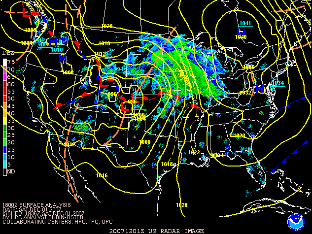 A low-pressure system developed across the southwestern United States moved across the central parts of North America on December 1, becoming a Colorado Low
with an initial between moving from Nebraska to northern Ontario and into the Middle Atlantic Coast near New York City. A second band originating from a band of thunderstorms across Missouri then traveled across the Great Lakes and the Northeast. A newly formed low pressure off the coast of New Jersey then moved across Maine and the Canadian Maritimes.
Areas of the Middle Plains and the lower Great Lakes including Des Moines
, Chicago
, Milwaukee, Detroit and Toronto
received a significant wintry mix of precipitation before changing to rain and thunderstorms on December 1 and 2. Des Moines International Airport
was shut down for several hours due to the icing conditions on runways and an American Airlines
flight with 44 passengers slipped out of a taxiway while another skidded out of a runway at Madison, Wisconsin
's Dane County Regional Airport
. Numerous passengers were stranded for several hours at Chicago's O'Hare International Airport where 400 flights were canceled on December 1 alone. About 140,000 customers in Illinois alone lost power.
Portions of Wisconsin
, Minnesota
and northern Ontario received several inches of snow while the mountain regions of Colorado received as much as four feet of snow (120 cm), resulting in the postponement of the men's Super-G alpine skiing event in Beaver Creek, Colorado
, where 15 inches (38.1 cm) was reported.
Portions of the Northeast including most of northern and eastern Ontario and central and southern Quebec received 8 to 16 inches (40.6 cm) of snow from the second band of precipitation while freezing rain was reported south of the Great Lakes across New York and Pennsylvania. Portions of Maine and the Maritimes affected by the coastal low received as much as 18 inches (45 cm) of snow.
The storm was responsible for at least 16 deaths including three in Quebec
, one in New York
, one in Maine
, one in Indiana
, three in Wisconsin
, two in Illinois
, three in Michigan, one in Utah
, and one in Colorado
.
brought heavy snow to portions of British Columbia, including the South Coast and Vancouver Island, with amounts in higher elevations exceeding 16 inches (40 cm) and significant accumulations also for Metro Vancouver. Another large storm called a Pineapple Express
brought torrential rains to the same areas on December 3 with very strong winds across portions of Oregon
and Washington states, freezing rain into valley areas of central British Columbia, and heavy snow of up to 2 foot (0.6096 m) across mountainous areas. The heavy rains caused a mudslide inside Stanley Park which closed its seawall which had just recently re-opened in November after it was heavily damaged during a major wind storm in December 2006. Extensive flooding was reported across many areas of Washington and Oregon after heavy rains with amounts of up to 10 inches (254 mm) were reported. Coast Guard helicopters had to evacuate and saved over 100 residents who were trapped by the high water levels. The town of Vernonia, Oregon
was completely cut-off by the water and mudslides. Wind gusts locally exceeded 100 mph (160 km/h) with the highest gust registered at 129 mi/h recorded in Bay City, Oregon
. Over 100,000 customers from northern California to Washington lost electricity while 40,000 lost power in British Columbia. In addition, Amtrak
service between Portland, Oregon and Vancouver, British Columbia was disrupted for at least two days.
The storm was responsible for at least 10 deaths, including five in a single vehicle crash near Prince George, British Columbia
where there was snow-covered roads. Three people were killed in Washington and two in Oregon. From the perspective of Chicago, the storm was viewed as an Alberta clipper
with the potential for heavy snowfall. During the evening of December 2, the storm was reported to have a central pressure of 949 mb, pressures associated with a Category 3 hurricane.
The same storm entered the Upper Midwest
as an Alberta Clipper
, which brought light to moderate snowfall over much of the Midwest on December 4 and early December 5, and overspread the Ohio Valley and Mid-Atlantic
states on December 5. The Minneapolis-St. Paul, Madison
, Milwaukee
, and Chicago
metropolitan areas saw upwards of 4 to 8 inches (20.3 cm) of snow from the storm system, with areas further south and east receiving less.
 A series of winter storms impacted widespread areas of North America over a nine-day period. From December 8 to December 11, another major ice storm impacted the midsection of the United States from Texas
, northeast through the Midwest, through the Mid-Atlantic States
, and into southern New England
. At least 38 people were killed by the ice storms, including 23 in Oklahoma
, four in Kansas
, three in Missouri
, and one in Nebraska
. Most of the fatalities were the result of traffic accidents caused by the icy weather, including four people in a single accident on Interstate 40
west of Okemah, Oklahoma
. The storm caused the largest power outage in Oklahoma history, where 600,000 homes and businesses lost power, while 350,000 customers were also without power in other states, including 100,000 in both Missouri
and Kansas, and scattered power outages in Nebraska
, Iowa
, and Illinois
. Overall, over 1.5 million customers lost power throughout the Central United States
with some being without electricity for over one week. The storms caused widespread school and flight cancellations with Chicago O'Hare International Airport cancelling at least 560 flights, while Tulsa International Airport
was forced to halt flights on the 10th after losing power for 10 hours.
The energy of the second ice storm produced significant snows over the northeastern part of the US and the Golden Horseshoe
region of Ontario on December 13 and dumped as much as 12 inches (30 cm) of snow in parts of New England and New York state. A large system crossed the Central and Eastern part of the continent from December 15 to December 17 dumping as much as 20 inches (50.8 cm) over parts of Ontario and New England with mixed precipitation south of the heavy snow bands. The snow storm was responsible for at least 17 deaths across five states and three Canadian provinces as well as numerous flights and school cancellations from Michigan to the Canadian Maritimes.
and Barcelona
was also shut down due to the weather.
to northern Ontario while heavy rains, areas of freezing rain, very strong winds and warm temperatures affected most of Eastern North America. Blizzard warnings were issued at one point over southwestern Kansas and locally a foot of snow fell in some regions with several regions registering wind gusts of over 50 mi/h. Up to a foot of snow fell across much of Minnesota, Wisconsin, and Michigan, and freezing rain was also reported in many areas. Parts of Michigan's Upper Peninsula
saw upwards of 15 inches (38.1 cm) of snow. The storm also produced strong winds, including wind gusts of 88 mi/h across Lake Michigan
, and gusts ranging from 50–68 mph across the Chicago area. The winds caused 300 flights to be canceled at Chicago-O'Hare International Airport. Also in Chicago, crews reported that 170 signals had been knocked out and more than 500 reports of fallen limbs had been attributed to the storm. 11,000 customers in Wisconsin, 92,000 in Michigan and 225,000 in Illinois lost power. The storm was responsible for at least 25 deaths across seven US states and one Canadian province, including eight in Minnesota, three in Indiana, three in Wyoming
, five in Wisconsin, one in Texas
, one in Kansas, one in Michigan, and three in New Brunswick. In Texas, the fatal crash included 50 vehicles on Interstate 40
while in Kansas and Missouri crashes on Interstate 70
and Interstate 29
respectively also involved several vehicles. Lake-effect snows across the traditional snowbelt
region in the Great Lakes also fell on Christmas Eve
.
Winter storm
A winter storm is an event in which the dominant varieties of precipitation are formed that only occur at low temperatures, such as snow or sleet, or a rainstorm where ground temperatures are low enough to allow ice to form...
s are events in which the dominant varieties of precipitation
Precipitation (meteorology)
In meteorology, precipitation In meteorology, precipitation In meteorology, precipitation (also known as one of the classes of hydrometeors, which are atmospheric water phenomena is any product of the condensation of atmospheric water vapor that falls under gravity. The main forms of precipitation...
are forms that only occur at cold temperature
Temperature
Temperature is a physical property of matter that quantitatively expresses the common notions of hot and cold. Objects of low temperature are cold, while various degrees of higher temperatures are referred to as warm or hot...
s, such as snow
Snow
Snow is a form of precipitation within the Earth's atmosphere in the form of crystalline water ice, consisting of a multitude of snowflakes that fall from clouds. Since snow is composed of small ice particles, it is a granular material. It has an open and therefore soft structure, unless packed by...
or sleet
Rain and snow mixed
Rain and snow mixed is precipitation composed of rain and partially melted snow. This precipitation can occur where the temperature in the lower part of the atmosphere is slightly above the freezing point...
, or a rainstorm where ground temperatures are cold enough to allow ice
Ice
Ice is water frozen into the solid state. Usually ice is the phase known as ice Ih, which is the most abundant of the varying solid phases on the Earth's surface. It can appear transparent or opaque bluish-white color, depending on the presence of impurities or air inclusions...
to form (i.e. freezing rain
Freezing rain
Freezing rain is the name given to rain that falls when surface temperatures are below freezing. The raindrops become supercooled while passing through a sub-freezing layer of air, many hundred feet , just above the surface, and then freeze upon impact with any object they encounter. The resulting...
). It may be marked by strong wind
Wind
Wind is the flow of gases on a large scale. On Earth, wind consists of the bulk movement of air. In outer space, solar wind is the movement of gases or charged particles from the sun through space, while planetary wind is the outgassing of light chemical elements from a planet's atmosphere into space...
, thunder
Thunder
Thunder is the sound made by lightning. Depending on the nature of the lightning and distance of the listener, thunder can range from a sharp, loud crack to a long, low rumble . The sudden increase in pressure and temperature from lightning produces rapid expansion of the air surrounding and within...
and lightning
Lightning
Lightning is an atmospheric electrostatic discharge accompanied by thunder, which typically occurs during thunderstorms, and sometimes during volcanic eruptions or dust storms...
(a thunderstorm
Thunderstorm
A thunderstorm, also known as an electrical storm, a lightning storm, thundershower or simply a storm is a form of weather characterized by the presence of lightning and its acoustic effect on the Earth's atmosphere known as thunder. The meteorologically assigned cloud type associated with the...
), heavy precipitation
Precipitation (meteorology)
In meteorology, precipitation In meteorology, precipitation In meteorology, precipitation (also known as one of the classes of hydrometeors, which are atmospheric water phenomena is any product of the condensation of atmospheric water vapor that falls under gravity. The main forms of precipitation...
, such as ice (ice storm
Winter storm
A winter storm is an event in which the dominant varieties of precipitation are formed that only occur at low temperatures, such as snow or sleet, or a rainstorm where ground temperatures are low enough to allow ice to form...
), or wind transporting some substance through the atmosphere
Earth's atmosphere
The atmosphere of Earth is a layer of gases surrounding the planet Earth that is retained by Earth's gravity. The atmosphere protects life on Earth by absorbing ultraviolet solar radiation, warming the surface through heat retention , and reducing temperature extremes between day and night...
(as in a dust storm
Dust storm
A dust / sand storm is a meteorological phenomenon common in arid and semi-arid regions. Dust storms arise when a gust front or other strong wind blows loose sand and dirt from a dry surface. Particles are transported by saltation and suspension, causing soil to move from one place and deposition...
, snowstorm, hail
Hail
Hail is a form of solid precipitation. It consists of balls or irregular lumps of ice, each of which is referred to as a hail stone. Hail stones on Earth consist mostly of water ice and measure between and in diameter, with the larger stones coming from severe thunderstorms...
storm, etc.). Other major non winter events such as large dust storms, Hurricanes, cyclone
Cyclone
In meteorology, a cyclone is an area of closed, circular fluid motion rotating in the same direction as the Earth. This is usually characterized by inward spiraling winds that rotate anticlockwise in the Northern Hemisphere and clockwise in the Southern Hemisphere of the Earth. Most large-scale...
s, tornado
Tornado
A tornado is a violent, dangerous, rotating column of air that is in contact with both the surface of the earth and a cumulonimbus cloud or, in rare cases, the base of a cumulus cloud. They are often referred to as a twister or a cyclone, although the word cyclone is used in meteorology in a wider...
s, gale
Gale
A gale is a very strong wind. There are conflicting definitions of how strong a wind must be to be considered a gale. The U.S. government's National Weather Service defines a gale as 34–47 knots of sustained surface winds. Forecasters typically issue gale warnings when winds of this strength are...
s, flooding and rainstorms are also caused by such phenomena to a lesser or greater existent.
Very rarely, they may form in summer, though it would have to be an abnormally cold summer, such as the summer of 1816
Year Without a Summer
The Year Without a Summer was 1816, in which severe summer climate abnormalities caused average global temperatures to decrease by about 0.4–0.7 °C , resulting in major food shortages across the Northern Hemisphere...
in the Northeast United States of America. In many locations in the Northern Hemisphere, the most powerful winter storms usually occur in March and, in regions where temperatures are cold enough, April.
January 9–12
A low pressure brought up heavy snow and blizzardBlizzard
A blizzard is a severe snowstorm characterized by strong winds. By definition, the difference between blizzard and a snowstorm is the strength of the wind. To be a blizzard, a snow storm must have winds in excess of with blowing or drifting snow which reduces visibility to 400 meters or ¼ mile or...
conditions across the Canadian Prairies. Snowfall locally reached between 8 inches (20 cm) to 1 foot (30 cm) in parts of Alberta
Alberta
Alberta is a province of Canada. It had an estimated population of 3.7 million in 2010 making it the most populous of Canada's three prairie provinces...
, Saskatchewan
Saskatchewan
Saskatchewan is a prairie province in Canada, which has an area of . Saskatchewan is bordered on the west by Alberta, on the north by the Northwest Territories, on the east by Manitoba, and on the south by the U.S. states of Montana and North Dakota....
and Manitoba
Manitoba
Manitoba is a Canadian prairie province with an area of . The province has over 110,000 lakes and has a largely continental climate because of its flat topography. Agriculture, mostly concentrated in the fertile southern and western parts of the province, is vital to the province's economy; other...
. Particularly hard-hit was central Saskatchewan, including the city of Saskatoon
Saskatoon
Saskatoon is a city in central Saskatchewan, Canada, on the South Saskatchewan River. Residents of the city of Saskatoon are called Saskatonians. The city is surrounded by the Rural Municipality of Corman Park No. 344....
. The storm was accompanied by strong gusty winds in excess of 40 mph (64 km/h). Two people were killed during the blizzard when their car was stuck near a First Nations
First Nations
First Nations is a term that collectively refers to various Aboriginal peoples in Canada who are neither Inuit nor Métis. There are currently over 630 recognised First Nations governments or bands spread across Canada, roughly half of which are in the provinces of Ontario and British Columbia. The...
reserve in Saskatchewan
Saskatchewan
Saskatchewan is a prairie province in Canada, which has an area of . Saskatchewan is bordered on the west by Alberta, on the north by the Northwest Territories, on the east by Manitoba, and on the south by the U.S. states of Montana and North Dakota....
. Saskatoon's Diefenbaker Airport as well as schools were closed.
Prior of hitting the Prairies, the system brought another windstorm to western British Columbia
British Columbia
British Columbia is the westernmost of Canada's provinces and is known for its natural beauty, as reflected in its Latin motto, Splendor sine occasu . Its name was chosen by Queen Victoria in 1858...
, with gusts exceeding 60 mph (100 km/h). Additional trees at Vancouver
Vancouver
Vancouver is a coastal seaport city on the mainland of British Columbia, Canada. It is the hub of Greater Vancouver, which, with over 2.3 million residents, is the third most populous metropolitan area in the country,...
's Stanley Park
Stanley Park
Stanley Park is a 404.9 hectare urban park bordering downtown Vancouver, British Columbia, Canada. It was opened in 1888 by David Oppenheimer in the name of Lord Stanley of Preston, the Governor-General of Canada....
were uprooted. It also hindered efforts from workers who were trying to repair the inflatable roof of BC Place Stadium
BC Place Stadium
BC Place is a multi-purpose stadium located at the north side of False Creek, in Vancouver, British Columbia, Canada. It serves as the home field for the BC Lions of the Canadian Football League and the Vancouver Whitecaps FC of Major League Soccer . Originally opened on June 19, 1983 as the...
(home to the Canadian Football League
Canadian Football League
The Canadian Football League or CFL is a professional sports league located in Canada. The CFL is the highest level of competition in Canadian football, a form of gridiron football closely related to American football....
's BC Lions
BC Lions
The BC Lions are a professional Canadian football team competing in the West Division of Canadian Football League . Based in Vancouver, British Columbia, the Lions play their home games at BC Place Stadium in Downtown Vancouver, having previously played at Empire Stadium in East Vancouver from 1954...
), which was damaged by winds from a previous storm a few days earlier. A secondary wave following the main storm dumped over 4 inches of snow (10 cm) in the Victoria
Victoria, British Columbia
Victoria is the capital city of British Columbia, Canada and is located on the southern tip of Vancouver Island off Canada's Pacific coast. The city has a population of about 78,000 within the metropolitan area of Greater Victoria, which has a population of 360,063, the 15th most populous Canadian...
, Vancouver
Vancouver
Vancouver is a coastal seaport city on the mainland of British Columbia, Canada. It is the hub of Greater Vancouver, which, with over 2.3 million residents, is the third most populous metropolitan area in the country,...
, and Seattle areas with heavier snow in the mountains. Over 115,000 homes were without power during the storm in B.C.
The storm would later drop some locally heavy amount of snows in parts of northern Ontario
Ontario
Ontario is a province of Canada, located in east-central Canada. It is Canada's most populous province and second largest in total area. It is home to the nation's most populous city, Toronto, and the nation's capital, Ottawa....
and central Quebec
Quebec
Quebec or is a province in east-central Canada. It is the only Canadian province with a predominantly French-speaking population and the only one whose sole official language is French at the provincial level....
with 8 inches (20 cm) reported in Saguenay
Saguenay, Quebec
Saguenay is a city in the Saguenay-Lac-Saint-Jean region of Quebec, Canada, on the Saguenay River, about north of Quebec City....
.
A cold front sharply drop temperatures from west to east with some areas getting their coldest days of the season across the Canadian and U.S. plains. The cold air later reached the eastern half of the continent at the end of the week.
January 12–24
Following a prolonged period of mild weather, a series of winter storms produced several waves of damaging freezing rain across the Midwest of the United States and central CanadaCanada
Canada is a North American country consisting of ten provinces and three territories. Located in the northern part of the continent, it extends from the Atlantic Ocean in the east to the Pacific Ocean in the west, and northward into the Arctic Ocean...
from the 12th to the 16th causing the deaths of 85 people as of January 20. Several thousands of customers from Texas
Texas
Texas is the second largest U.S. state by both area and population, and the largest state by area in the contiguous United States.The name, based on the Caddo word "Tejas" meaning "friends" or "allies", was applied by the Spanish to the Caddo themselves and to the region of their settlement in...
to New England
New England
New England is a region in the northeastern corner of the United States consisting of the six states of Maine, New Hampshire, Vermont, Massachusetts, Rhode Island, and Connecticut...
lost power, some for several days. Some areas received as much as 4 inches of ice (100 mm).
Oklahoma
Oklahoma
Oklahoma is a state located in the South Central region of the United States of America. With an estimated 3,751,351 residents as of the 2010 census and a land area of 68,667 square miles , Oklahoma is the 28th most populous and 20th-largest state...
and Missouri
Missouri
Missouri is a US state located in the Midwestern United States, bordered by Iowa, Illinois, Kentucky, Tennessee, Arkansas, Oklahoma, Kansas and Nebraska. With a 2010 population of 5,988,927, Missouri is the 18th most populous state in the nation and the fifth most populous in the Midwest. It...
were declared disaster areas as they were the most hard hit states from the storms. Areas from Utah
Utah
Utah is a state in the Western United States. It was the 45th state to join the Union, on January 4, 1896. Approximately 80% of Utah's 2,763,885 people live along the Wasatch Front, centering on Salt Lake City. This leaves vast expanses of the state nearly uninhabited, making the population the...
to New Brunswick
New Brunswick
New Brunswick is one of Canada's three Maritime provinces and is the only province in the federation that is constitutionally bilingual . The provincial capital is Fredericton and Saint John is the most populous city. Greater Moncton is the largest Census Metropolitan Area...
received heavy amounts of snow from the 13th to the 16th. The storm was followed by an intense period of cold across most of the continent from California
California
California is a state located on the West Coast of the United States. It is by far the most populous U.S. state, and the third-largest by land area...
to Newfoundland and Labrador
Newfoundland and Labrador
Newfoundland and Labrador is the easternmost province of Canada. Situated in the country's Atlantic region, it incorporates the island of Newfoundland and mainland Labrador with a combined area of . As of April 2011, the province's estimated population is 508,400...
.
Additional waves of precipitation have affected the south half of the United States from the 16th to 18th from Texas to North Carolina
North Carolina
North Carolina is a state located in the southeastern United States. The state borders South Carolina and Georgia to the south, Tennessee to the west and Virginia to the north. North Carolina contains 100 counties. Its capital is Raleigh, and its largest city is Charlotte...
, while another winter storm, called a weather bomb affected portions of New Brunswick, Quebec
Quebec
Quebec or is a province in east-central Canada. It is the only Canadian province with a predominantly French-speaking population and the only one whose sole official language is French at the provincial level....
and Maine
Maine
Maine is a state in the New England region of the northeastern United States, bordered by the Atlantic Ocean to the east and south, New Hampshire to the west, and the Canadian provinces of Quebec to the northwest and New Brunswick to the northeast. Maine is both the northernmost and easternmost...
on the 19th and 20th with near blizzard conditions. Portions of eastern Quebec received as much as 32 inches of snow (80 cm) in just over 12 hours
A total of 85 deaths across 12 U.S. states and three Canadian provinces, and caused hundreds of thousands of residents across the U.S and Canada to lose electric power
Power outage
A power outage is a short- or long-term loss of the electric power to an area.There are many causes of power failures in an electricity network...
.
Most of them were in road traffic accidents, by the series of winter storms; 14 in Missouri
Missouri
Missouri is a US state located in the Midwestern United States, bordered by Iowa, Illinois, Kentucky, Tennessee, Arkansas, Oklahoma, Kansas and Nebraska. With a 2010 population of 5,988,927, Missouri is the 18th most populous state in the nation and the fifth most populous in the Midwest. It...
, 8 in Iowa
Iowa
Iowa is a state located in the Midwestern United States, an area often referred to as the "American Heartland". It derives its name from the Ioway people, one of the many American Indian tribes that occupied the state at the time of European exploration. Iowa was a part of the French colony of New...
, 12 in Texas
Texas
Texas is the second largest U.S. state by both area and population, and the largest state by area in the contiguous United States.The name, based on the Caddo word "Tejas" meaning "friends" or "allies", was applied by the Spanish to the Caddo themselves and to the region of their settlement in...
, 2 in Minnesota
Minnesota
Minnesota is a U.S. state located in the Midwestern United States. The twelfth largest state of the U.S., it is the twenty-first most populous, with 5.3 million residents. Minnesota was carved out of the eastern half of the Minnesota Territory and admitted to the Union as the thirty-second state...
, 4 in New York
New York
New York is a state in the Northeastern region of the United States. It is the nation's third most populous state. New York is bordered by New Jersey and Pennsylvania to the south, and by Connecticut, Massachusetts and Vermont to the east...
, 1 in Maine
Maine
Maine is a state in the New England region of the northeastern United States, bordered by the Atlantic Ocean to the east and south, New Hampshire to the west, and the Canadian provinces of Quebec to the northwest and New Brunswick to the northeast. Maine is both the northernmost and easternmost...
, 1 in Indiana
Indiana
Indiana is a US state, admitted to the United States as the 19th on December 11, 1816. It is located in the Midwestern United States and Great Lakes Region. With 6,483,802 residents, the state is ranked 15th in population and 16th in population density. Indiana is ranked 38th in land area and is...
, 4 in Michigan
Michigan
Michigan is a U.S. state located in the Great Lakes Region of the United States of America. The name Michigan is the French form of the Ojibwa word mishigamaa, meaning "large water" or "large lake"....
, 3 in Arkansas
Arkansas
Arkansas is a state located in the southern region of the United States. Its name is an Algonquian name of the Quapaw Indians. Arkansas shares borders with six states , and its eastern border is largely defined by the Mississippi River...
, 1 in Quebec
Quebec
Quebec or is a province in east-central Canada. It is the only Canadian province with a predominantly French-speaking population and the only one whose sole official language is French at the provincial level....
, 1 in Ontario
Ontario
Ontario is a province of Canada, located in east-central Canada. It is Canada's most populous province and second largest in total area. It is home to the nation's most populous city, Toronto, and the nation's capital, Ottawa....
, 1 in Nova Scotia
Nova Scotia
Nova Scotia is one of Canada's three Maritime provinces and is the most populous province in Atlantic Canada. The name of the province is Latin for "New Scotland," but "Nova Scotia" is the recognized, English-language name of the province. The provincial capital is Halifax. Nova Scotia is the...
, 2 in North Carolina
North Carolina
North Carolina is a state located in the southeastern United States. The state borders South Carolina and Georgia to the south, Tennessee to the west and Virginia to the north. North Carolina contains 100 counties. Its capital is Raleigh, and its largest city is Charlotte...
, 2 in Kansas
Kansas
Kansas is a US state located in the Midwestern United States. It is named after the Kansas River which flows through it, which in turn was named after the Kansa Native American tribe, which inhabited the area. The tribe's name is often said to mean "people of the wind" or "people of the south...
, 4 in Nebraska
Nebraska
Nebraska is a state on the Great Plains of the Midwestern United States. The state's capital is Lincoln and its largest city is Omaha, on the Missouri River....
and 25 in Oklahoma
Oklahoma
Oklahoma is a state located in the South Central region of the United States of America. With an estimated 3,751,351 residents as of the 2010 census and a land area of 68,667 square miles , Oklahoma is the 28th most populous and 20th-largest state...
. An accident near Elk City, Oklahoma
Elk City, Oklahoma
Elk City is a city in Beckham County, Oklahoma, United States. The population was 11,693 at the 2010 census. Elk City is located on Interstate 40 and Historic U.S. Route 66 in Western Oklahoma, approximately west of Oklahoma City and east of Amarillo....
, killed 7 occupants who were inside a minivan
Minivan
Minivan is a type of van designed for personal use. Minivans are typically either two-box or one box designs for maximum interior volume – and are taller than a sedan, hatchback, or a station wagon....
when it collided with a tractor-trailer during the storm.
Another winter storm affected the central and southern Plains from the 19th to the 21st bringing snow and ice for most of the area with accumulations that topped off at about 4 to 10 inches of snow (10–25 cm). It also brought a light wintry mix across the Ohio Valley and the mid-Atlantic states on the 21st with little accumulation. Newfoundland and Labrador
Newfoundland and Labrador
Newfoundland and Labrador is the easternmost province of Canada. Situated in the country's Atlantic region, it incorporates the island of Newfoundland and mainland Labrador with a combined area of . As of April 2011, the province's estimated population is 508,400...
was the last region affected by the series of storms on the 23rd and 24th.
January 14
Per was the name of a powerful stormStorm
A storm is any disturbed state of an astronomical body's atmosphere, especially affecting its surface, and strongly implying severe weather...
with hurricane winds which hit the west coast of Sweden
Sweden
Sweden , officially the Kingdom of Sweden , is a Nordic country on the Scandinavian Peninsula in Northern Europe. Sweden borders with Norway and Finland and is connected to Denmark by a bridge-tunnel across the Öresund....
and Norway
Norway
Norway , officially the Kingdom of Norway, is a Nordic unitary constitutional monarchy whose territory comprises the western portion of the Scandinavian Peninsula, Jan Mayen, and the Arctic archipelago of Svalbard and Bouvet Island. Norway has a total area of and a population of about 4.9 million...
on the morning of 14 January 2007. In Sweden six people died from the storm and approx. 300,000 households were left without electricity
Electricity
Electricity is a general term encompassing a variety of phenomena resulting from the presence and flow of electric charge. These include many easily recognizable phenomena, such as lightning, static electricity, and the flow of electrical current in an electrical wire...
. 6 Sweeds died in the storm.
January 15–19
European windstorm
A European windstorm is a severe cyclonic windstorm associated with areas of low atmospheric pressure that track across the North Atlantic towards northwestern Europe. They are most common in the winter months...
gave heavy amounts of snow across portions of Scotland
Scotland
Scotland is a country that is part of the United Kingdom. Occupying the northern third of the island of Great Britain, it shares a border with England to the south and is bounded by the North Sea to the east, the Atlantic Ocean to the north and west, and the North Channel and Irish Sea to the...
. Most areas of western Europe from Great Britain
Great Britain
Great Britain or Britain is an island situated to the northwest of Continental Europe. It is the ninth largest island in the world, and the largest European island, as well as the largest of the British Isles...
to the Czech Republic
Czech Republic
The Czech Republic is a landlocked country in Central Europe. The country is bordered by Poland to the northeast, Slovakia to the east, Austria to the south, and Germany to the west and northwest....
have experienced damaging winds. Wind gusts have reached 90 mph (150 km/h) in the plain and up to 140 mph (225 km/h) in the mountain area. Boat
Boat
A boat is a watercraft of any size designed to float or plane, to provide passage across water. Usually this water will be inland or in protected coastal areas. However, boats such as the whaleboat were designed to be operated from a ship in an offshore environment. In naval terms, a boat is a...
, rail
Rail transport
Rail transport is a means of conveyance of passengers and goods by way of wheeled vehicles running on rail tracks. In contrast to road transport, where vehicles merely run on a prepared surface, rail vehicles are also directionally guided by the tracks they run on...
and air traffic have been heavily affected, while several hundreds of flights from London
London
London is the capital city of :England and the :United Kingdom, the largest metropolitan area in the United Kingdom, and the largest urban zone in the European Union by most measures. Located on the River Thames, London has been a major settlement for two millennia, its history going back to its...
, Berlin
Berlin
Berlin is the capital city of Germany and is one of the 16 states of Germany. With a population of 3.45 million people, Berlin is Germany's largest city. It is the second most populous city proper and the seventh most populous urban area in the European Union...
, Amsterdam
Amsterdam
Amsterdam is the largest city and the capital of the Netherlands. The current position of Amsterdam as capital city of the Kingdom of the Netherlands is governed by the constitution of August 24, 1815 and its successors. Amsterdam has a population of 783,364 within city limits, an urban population...
, Vienna
Vienna
Vienna is the capital and largest city of the Republic of Austria and one of the nine states of Austria. Vienna is Austria's primary city, with a population of about 1.723 million , and is by far the largest city in Austria, as well as its cultural, economic, and political centre...
, Prague
Prague
Prague is the capital and largest city of the Czech Republic. Situated in the north-west of the country on the Vltava river, the city is home to about 1.3 million people, while its metropolitan area is estimated to have a population of over 2.3 million...
and Paris
Paris
Paris is the capital and largest city in France, situated on the river Seine, in northern France, at the heart of the Île-de-France region...
have been delayed or canceled. U.S. Secretary of State
Secretary of State
Secretary of State or State Secretary is a commonly used title for a senior or mid-level post in governments around the world. The role varies between countries, and in some cases there are multiple Secretaries of State in the Government....
Condoleezza Rice
Condoleezza Rice
Condoleezza Rice is an American political scientist and diplomat. She served as the 66th United States Secretary of State, and was the second person to hold that office in the administration of President George W. Bush...
shortened her European trip due to the strong winds. Millions of residents were without power including 1 million in the Czech Republic
Czech Republic
The Czech Republic is a landlocked country in Central Europe. The country is bordered by Poland to the northeast, Slovakia to the east, Austria to the south, and Germany to the west and northwest....
. As of 9:00 PM GMT on January 21, Kyrill had caused 47 fatalities. They were- 13 in Germany, 11 in United Kingdom, 7 in Ireland, 6 in The Netherlands, 4 in Poland , 3 in the Czech Republic 3, 1 in France, 1in Belgium and 1 in Austria.
Germany had 3 tornadoes on February 22 and
More tornadoes were confirmed from Poland.
January 23–27
A snowstorm affected a large area of western and central Europe, including France, Great BritainGreat Britain
Great Britain or Britain is an island situated to the northwest of Continental Europe. It is the ninth largest island in the world, and the largest European island, as well as the largest of the British Isles...
, Austria
Austria
Austria , officially the Republic of Austria , is a landlocked country of roughly 8.4 million people in Central Europe. It is bordered by the Czech Republic and Germany to the north, Slovakia and Hungary to the east, Slovenia and Italy to the south, and Switzerland and Liechtenstein to the...
and Germany bringing locally heavy snow accumulations and ice which disrupted air and train travel in Berlin
Berlin
Berlin is the capital city of Germany and is one of the 16 states of Germany. With a population of 3.45 million people, Berlin is Germany's largest city. It is the second most populous city proper and the seventh most populous urban area in the European Union...
, Stuttgart
Stuttgart
Stuttgart is the capital of the state of Baden-Württemberg in southern Germany. The sixth-largest city in Germany, Stuttgart has a population of 600,038 while the metropolitan area has a population of 5.3 million ....
and London
London
London is the capital city of :England and the :United Kingdom, the largest metropolitan area in the United Kingdom, and the largest urban zone in the European Union by most measures. Located on the River Thames, London has been a major settlement for two millennia, its history going back to its...
. Some areas in the Alps
Alps
The Alps is one of the great mountain range systems of Europe, stretching from Austria and Slovenia in the east through Italy, Switzerland, Liechtenstein and Germany to France in the west....
region received as much as 1 meter of snow (40 inches). Three people were killed in Germany
Germany
Germany , officially the Federal Republic of Germany , is a federal parliamentary republic in Europe. The country consists of 16 states while the capital and largest city is Berlin. Germany covers an area of 357,021 km2 and has a largely temperate seasonal climate...
due to accidents caused by the storm. Over 5,000 motorists were stranded in a highway in eastern France
France
The French Republic , The French Republic , The French Republic , (commonly known as France , is a unitary semi-presidential republic in Western Europe with several overseas territories and islands located on other continents and in the Indian, Pacific, and Atlantic oceans. Metropolitan France...
due to the heavy snow amounts. Scattered power outages were reported with central France being affected the most with nearly 85,000 homes without power.
On the 27th abolut 40,000 people had been affected by flooding in Bolivia and Peru
February 1–2
A winter storm crossed through the southern United States, with a mix of winter weather. Several inches of snow fell across parts of ArkansasArkansas
Arkansas is a state located in the southern region of the United States. Its name is an Algonquian name of the Quapaw Indians. Arkansas shares borders with six states , and its eastern border is largely defined by the Mississippi River...
, Georgia
Georgia (U.S. state)
Georgia is a state located in the southeastern United States. It was established in 1732, the last of the original Thirteen Colonies. The state is named after King George II of Great Britain. Georgia was the fourth state to ratify the United States Constitution, on January 2, 1788...
, the Carolinas and Tennessee
Tennessee
Tennessee is a U.S. state located in the Southeastern United States. It has a population of 6,346,105, making it the nation's 17th-largest state by population, and covers , making it the 36th-largest by total land area...
with scattered sleet and freezing rain farther south. Anywhere from 1-4 inches of snow fell across Tennessee and Arkansas, with lighter amounts in the Carolinas.
February 1–12
A major lake effect snowLake effect snow
Lake-effect snow is produced during cooler atmospheric conditions when cold winds move across long expanses of warmer lake water, providing energy and picking up water vapor which freezes and is deposited on the leeward shores...
event, titled Lake Storm "Locust", occurred across the Great Lakes
Great Lakes
The Great Lakes are a collection of freshwater lakes located in northeastern North America, on the Canada – United States border. Consisting of Lakes Superior, Michigan, Huron, Erie, and Ontario, they form the largest group of freshwater lakes on Earth by total surface, coming in second by volume...
regions for several days. Areas most affected by the localized heavy burst of snows were just east of Georgian Bay
Georgian Bay
Georgian Bay is a large bay of Lake Huron, located entirely within Ontario, Canada...
area near Parry Sound
Parry Sound, Ontario
Parry Sound is a town in Central Ontario, Canada, located on Parry Sound on the eastern shore of Georgian Bay. Parry Sound is located south of Sudbury and north of Toronto. It is the seat of Parry Sound District, a popular cottage country region for Southern Ontario residents. It is also the...
, east of Lake Huron
Lake Huron
Lake Huron is one of the five Great Lakes of North America. Hydrologically, it comprises the larger portion of Lake Michigan-Huron. It is bounded on the east by the Canadian province of Ontario and on the west by the state of Michigan in the United States...
near Wiarton
Wiarton, Ontario
Wiarton is a community in Bruce County, Ontario, at the western end of Colpoys Bay, an inlet off Georgian Bay, on the Bruce Peninsula. The community is part of the town of South Bruce Peninsula, Ontario....
, in western Michigan
Michigan
Michigan is a U.S. state located in the Great Lakes Region of the United States of America. The name Michigan is the French form of the Ojibwa word mishigamaa, meaning "large water" or "large lake"....
, and in north central New York
New York
New York is a state in the Northeastern region of the United States. It is the nation's third most populous state. New York is bordered by New Jersey and Pennsylvania to the south, and by Connecticut, Massachusetts and Vermont to the east...
.
Areas near Oswego
Oswego, New York
Oswego is a city in Oswego County, New York, United States. The population was 18,142 at the 2010 census. Oswego is located on Lake Ontario in north-central New York and promotes itself as "The Port City of Central New York"...
and northeast of Syracuse
Syracuse, New York
Syracuse is a city in and the county seat of Onondaga County, New York, United States, the largest U.S. city with the name "Syracuse", and the fifth most populous city in the state. At the 2010 census, the city population was 145,170, and its metropolitan area had a population of 742,603...
received as much as 141 inches (358 cm) of snow during that period. There were unofficial reports that two towns on the Tug Hill Plateau
Tug Hill Plateau
The Tug Hill Plateau is an upland region in upstate New York in the USA, famous for heavy winter snow. The Tug Hill Region is west of the Adirondack Mountains and is separated from the Adirondacks by the Black River Valley. Although the region is and has traditionally been known as the Tug Hill...
southeast of Lake Ontario
Lake Ontario
Lake Ontario is one of the five Great Lakes of North America. It is bounded on the north and southwest by the Canadian province of Ontario, and on the south by the American state of New York. Ontario, Canada's most populous province, was named for the lake. In the Wyandot language, ontarío means...
received over 10 feet (305 cm) of snow — Redfield
Redfield, New York
Redfield is a town in Oswego County, New York, USA. The population was 607 at the 2000 census.The Town of Redfield was incorporated from part of the Town of Mexico in 1800...
, with 141 inches (358 cm) and Parish
Parish (town), New York
Parish is a town in Oswego County, New York, United States. The population was 2,694 at the 2000 census.The Town of Parish was created from the Town of Mexico in 1828...
, with 121 inches (307 cm). Local accumulations elsewhere on the plateau were well over 1 meter (3.3 ft). A state of emergency
State of emergency
A state of emergency is a governmental declaration that may suspend some normal functions of the executive, legislative and judicial powers, alert citizens to change their normal behaviours, or order government agencies to implement emergency preparedness plans. It can also be used as a rationale...
was declared in Oswego County
Oswego County, New York
Oswego County is a county located in the U.S. state of New York. As of the 2010 Census, the estimated population was 122,109. The City of Oswego and the Village of Pulaski serve as the dual county seats in a two shire system of government...
due to the intense snow. Portions of central Ontario received 1–3 feet (30–90 cm) of snow over the period while heavy accumulations were also reported in western Michigan
Michigan
Michigan is a U.S. state located in the Great Lakes Region of the United States of America. The name Michigan is the French form of the Ojibwa word mishigamaa, meaning "large water" or "large lake"....
just off the shores of Lake Michigan
Lake Michigan
Lake Michigan is one of the five Great Lakes of North America and the only one located entirely within the United States. It is the second largest of the Great Lakes by volume and the third largest by surface area, after Lake Superior and Lake Huron...
.
On February 1, a snow squall just east of Oshawa
Oshawa
Oshawa is a city in Ontario, Canada, on the Lake Ontario shoreline. It lies in Southern Ontario approximately 60 kilometres east of downtown Toronto. It is commonly viewed as the eastern anchor of both the Greater Toronto Area and the Golden Horseshoe. It is now commonly referred to as the most...
, Ontario
Ontario
Ontario is a province of Canada, located in east-central Canada. It is Canada's most populous province and second largest in total area. It is home to the nation's most populous city, Toronto, and the nation's capital, Ottawa....
on the north shore of Lake Ontario caused a 15-vehicle pileup including a tractor trailer which burst into flames. Two people were killed in the event. There were no reported deaths related to the event in New York State. However, 20 were killed in other states due to cold weather. The event was very localized; areas outside the narrow bands received little or no snow.
February 7–9
A winter storm blanketed parts of the United KingdomUnited Kingdom
The United Kingdom of Great Britain and Northern IrelandIn the United Kingdom and Dependencies, other languages have been officially recognised as legitimate autochthonous languages under the European Charter for Regional or Minority Languages...
including the City of London
London
London is the capital city of :England and the :United Kingdom, the largest metropolitan area in the United Kingdom, and the largest urban zone in the European Union by most measures. Located on the River Thames, London has been a major settlement for two millennia, its history going back to its...
disrupting travel all across the city including numerous flights cancelled from all airports and several motorists were stranding on area roads. Service on the Underground
London Underground
The London Underground is a rapid transit system serving a large part of Greater London and some parts of Buckinghamshire, Hertfordshire and Essex in England...
subway system was also affected with several stations been closed. Many schools were also closed for one or two days. The heavy snowfall started life as a low-pressure system sitting out in the Atlantic Ocean
Atlantic Ocean
The Atlantic Ocean is the second-largest of the world's oceanic divisions. With a total area of about , it covers approximately 20% of the Earth's surface and about 26% of its water surface area...
, at the time the UK was under the influence of a cold northerly wind. The low pressure system tracked towards the UK on the evening of February 7 and turned readily to snow as it hit the cold air. The snow turned back to rain across southern and western regions, but much of Wales, the Midlands and the south-east had significant snowfalls on the 8th. The West Midlands in particular was badly hit, with up to 6 inches (15 cm) reported over high ground – the most snow to fall in this region for 15 years. In Wales
Wales
Wales is a country that is part of the United Kingdom and the island of Great Britain, bordered by England to its east and the Atlantic Ocean and Irish Sea to its west. It has a population of three million, and a total area of 20,779 km²...
, Sennybridge in Powys
Powys
Powys is a local-government county and preserved county in Wales.-Geography:Powys covers the historic counties of Montgomeryshire and Radnorshire, most of Brecknockshire , and a small part of Denbighshire — an area of 5,179 km², making it the largest county in Wales by land area.It is...
, reported 15 inches (38 cm) on level snow with drifts of up to 3 feet (90 cm) in places. On the 9th, the low pressure over France
France
The French Republic , The French Republic , The French Republic , (commonly known as France , is a unitary semi-presidential republic in Western Europe with several overseas territories and islands located on other continents and in the Indian, Pacific, and Atlantic oceans. Metropolitan France...
tracked further north than forecast, bringing more heavy snow for the Midlands
English Midlands
The Midlands, or the English Midlands, is the traditional name for the area comprising central England that broadly corresponds to the early medieval Kingdom of Mercia. It borders Southern England, Northern England, East Anglia and Wales. Its largest city is Birmingham, and it was an important...
and Wales. This caused additional travel disruption as the roads were not gritted and heavy gridlock formed on many of the roads. The snow began to thaw over the weekend and in turn caused some localised flooding.
February 12–16
Vermont
Vermont is a state in the New England region of the northeastern United States of America. The state ranks 43rd in land area, , and 45th in total area. Its population according to the 2010 census, 630,337, is the second smallest in the country, larger only than Wyoming. It is the only New England...
mountains. Burlington, Vermont
Burlington, Vermont
Burlington is the largest city in the U.S. state of Vermont and the shire town of Chittenden County. Burlington lies south of the U.S.-Canadian border and some south of Montreal....
set a 24-hour snowfall record, with 25.3 inches. Twelve to sixteen inches (30 to 41 cm) of snowfall and blizzard conditions in central Illinois cancelled classes at the University of Illinois at Urbana-Champaign
University of Illinois at Urbana-Champaign
The University of Illinois at Urbana–Champaign is a large public research-intensive university in the state of Illinois, United States. It is the flagship campus of the University of Illinois system...
for two days, the first time classes had been cancelled since 1979.
Large cities including Cleveland
Cleveland, Ohio
Cleveland is a city in the U.S. state of Ohio and is the county seat of Cuyahoga County, the most populous county in the state. The city is located in northeastern Ohio on the southern shore of Lake Erie, approximately west of the Pennsylvania border...
, Hamilton
Hamilton, Ontario
Hamilton is a port city in the Canadian province of Ontario. Conceived by George Hamilton when he purchased the Durand farm shortly after the War of 1812, Hamilton has become the centre of a densely populated and industrialized region at the west end of Lake Ontario known as the Golden Horseshoe...
, Syracuse
Syracuse, New York
Syracuse is a city in and the county seat of Onondaga County, New York, United States, the largest U.S. city with the name "Syracuse", and the fifth most populous city in the state. At the 2010 census, the city population was 145,170, and its metropolitan area had a population of 742,603...
, Rochester
Rochester, New York
Rochester is a city in Monroe County, New York, south of Lake Ontario in the United States. Known as The World's Image Centre, it was also once known as The Flour City, and more recently as The Flower City...
, Burlington
Burlington, Vermont
Burlington is the largest city in the U.S. state of Vermont and the shire town of Chittenden County. Burlington lies south of the U.S.-Canadian border and some south of Montreal....
, Quebec City
Quebec City
Quebec , also Québec, Quebec City or Québec City is the capital of the Canadian province of Quebec and is located within the Capitale-Nationale region. It is the second most populous city in Quebec after Montreal, which is about to the southwest...
and Sherbrooke received amounts well in excess of 1 foot of snow (30 cm). The city of Hamilton received local snowsqualls bombarding in from Lake Ontario
Lake Ontario
Lake Ontario is one of the five Great Lakes of North America. It is bounded on the north and southwest by the Canadian province of Ontario, and on the south by the American state of New York. Ontario, Canada's most populous province, was named for the lake. In the Wyandot language, ontarío means...
with a north-east wind which dumped over 2 feet of snow (75 cm) in some parts of the city.
Mixed precipitation fell across the southern Ohio Valley and the Interstate 95
Interstate 95
Interstate 95 is the main highway on the East Coast of the United States, running parallel to the Atlantic Ocean from Maine to Florida and serving some of the most populated urban areas in the country, including Boston, Providence, New Haven, New York City, Newark, Philadelphia, Baltimore,...
corridor from Virginia
Virginia
The Commonwealth of Virginia , is a U.S. state on the Atlantic Coast of the Southern United States. Virginia is nicknamed the "Old Dominion" and sometimes the "Mother of Presidents" after the eight U.S. presidents born there...
to Boston
Boston
Boston is the capital of and largest city in Massachusetts, and is one of the oldest cities in the United States. The largest city in New England, Boston is regarded as the unofficial "Capital of New England" for its economic and cultural impact on the entire New England region. The city proper had...
, including New York City
New York City
New York is the most populous city in the United States and the center of the New York Metropolitan Area, one of the most populous metropolitan areas in the world. New York exerts a significant impact upon global commerce, finance, media, art, fashion, research, technology, education, and...
, Washington, D.C.
Washington, D.C.
Washington, D.C., formally the District of Columbia and commonly referred to as Washington, "the District", or simply D.C., is the capital of the United States. On July 16, 1790, the United States Congress approved the creation of a permanent national capital as permitted by the U.S. Constitution....
and Philadelphia.
The storm has been blamed for 35 deaths across 13 states and three Canadian provinces.
February 19–24
A blizzard event took place across eastern Canada on the island of Newfoundland, dumping over 16 inches (40 cm) of snow in St. John'sSt. John's, Newfoundland and Labrador
St. John's is the capital and largest city in Newfoundland and Labrador, and is the oldest English-founded city in North America. It is located on the eastern tip of the Avalon Peninsula on the island of Newfoundland. With a population of 192,326 as of July 1, 2010, the St...
, the capital of Newfoundland and Labrador
Newfoundland and Labrador
Newfoundland and Labrador is the easternmost province of Canada. Situated in the country's Atlantic region, it incorporates the island of Newfoundland and mainland Labrador with a combined area of . As of April 2011, the province's estimated population is 508,400...
, shutting down most of the city, and closing all area schools. Heavy amounts were reported in the western Avalon Peninsula
Avalon Peninsula
The Avalon Peninsula is a large peninsula that makes up the southeast portion of the island of Newfoundland.The peninsula is home to 257,223 people, which is approximately 51% of Newfoundland's population in 2009, and is the location of the provincial capital, St. John's. It is connected to the...
of the province. The storm previously affected portions of Nova Scotia
Nova Scotia
Nova Scotia is one of Canada's three Maritime provinces and is the most populous province in Atlantic Canada. The name of the province is Latin for "New Scotland," but "Nova Scotia" is the recognized, English-language name of the province. The provincial capital is Halifax. Nova Scotia is the...
and dumped locally heavy amounts of snow due to sea effects coming from the Atlantic Ocean
Atlantic Ocean
The Atlantic Ocean is the second-largest of the world's oceanic divisions. With a total area of about , it covers approximately 20% of the Earth's surface and about 26% of its water surface area...
and the Bay of Fundy
Bay of Fundy
The Bay of Fundy is a bay on the Atlantic coast of North America, on the northeast end of the Gulf of Maine between the Canadian provinces of New Brunswick and Nova Scotia, with a small portion touching the U.S. state of Maine...
. A new storm on the 23rd and 24th dumped an additional 6 inches (15 cm)in the capital with freezing rain, while heavier amount fell just to the west.
February 21–26
California
California is a state located on the West Coast of the United States. It is by far the most populous U.S. state, and the third-largest by land area...
coast early on the 21st, leading to 1–3 feet (30–90 cm) of snow across the southern Cascades, Siskiyous
Siskiyou Mountains
The Siskiyou Mountains are a coastal mountain range in the northern Klamath Mountains in northwestern California and southwestern Oregon in the United States. They extend in an arc for approximately from east of Crescent City, California northeast along the north side of the Klamath River into...
, Sierra Nevada, and the mountains of southern California. It also gave moderate snowfall accumulations across the Canadian Prairies between 4 and 8 inches (10–20 cm) across Manitoba. The storm then moved east, bringing up to 2 feet (60 cm) to the mountains of Utah
Utah
Utah is a state in the Western United States. It was the 45th state to join the Union, on January 4, 1896. Approximately 80% of Utah's 2,763,885 people live along the Wasatch Front, centering on Salt Lake City. This leaves vast expanses of the state nearly uninhabited, making the population the...
and Colorado
Colorado
Colorado is a U.S. state that encompasses much of the Rocky Mountains as well as the northeastern portion of the Colorado Plateau and the western edge of the Great Plains...
. Late on the 23rd, it moved onto the central High Plains
High Plains (United States)
The High Plains are a subregion of the Great Plains mostly in the Western United States, but also partly in the Midwest states of Nebraska, Kansas, and South Dakota, generally encompassing the western part of the Great Plains before the region reaches the Rocky Mountains...
and organized into a major storm that spread snow from eastern Colorado
Colorado
Colorado is a U.S. state that encompasses much of the Rocky Mountains as well as the northeastern portion of the Colorado Plateau and the western edge of the Great Plains...
northeast into the Upper Midwest
Upper Midwest
The Upper Midwest is a region in the northern portion of the U.S. Census Bureau's Midwestern United States. It is largely a sub-region of the midwest. Although there are no uniformly agreed-upon boundaries, the region is most commonly used to refer to the states of Minnesota, Wisconsin, and...
and Great Lakes
Great Lakes
The Great Lakes are a collection of freshwater lakes located in northeastern North America, on the Canada – United States border. Consisting of Lakes Superior, Michigan, Huron, Erie, and Ontario, they form the largest group of freshwater lakes on Earth by total surface, coming in second by volume...
region, and ice from Iowa to northern Indiana. The system then split into two with the northern branch dissipating due to a blocking ridge of high pressure which prevented the blizzard from moving north into Canada
Canada
Canada is a North American country consisting of ten provinces and three territories. Located in the northern part of the continent, it extends from the Atlantic Ocean in the east to the Pacific Ocean in the west, and northward into the Arctic Ocean...
. The storm continued into the Mid-Atlantic on the 25th, dropping snow as far south as the Washington, D.C.
Washington, D.C.
Washington, D.C., formally the District of Columbia and commonly referred to as Washington, "the District", or simply D.C., is the capital of the United States. On July 16, 1790, the United States Congress approved the creation of a permanent national capital as permitted by the U.S. Constitution....
area.
Snowfall amounts from 12 to 24 inches (30–60 cm) were common in Minnesota
Minnesota
Minnesota is a U.S. state located in the Midwestern United States. The twelfth largest state of the U.S., it is the twenty-first most populous, with 5.3 million residents. Minnesota was carved out of the eastern half of the Minnesota Territory and admitted to the Union as the thirty-second state...
, Iowa
Iowa
Iowa is a state located in the Midwestern United States, an area often referred to as the "American Heartland". It derives its name from the Ioway people, one of the many American Indian tribes that occupied the state at the time of European exploration. Iowa was a part of the French colony of New...
, Wisconsin
Wisconsin
Wisconsin is a U.S. state located in the north-central United States and is part of the Midwest. It is bordered by Minnesota to the west, Iowa to the southwest, Illinois to the south, Lake Michigan to the east, Michigan to the northeast, and Lake Superior to the north. Wisconsin's capital is...
, and Illinois
Illinois
Illinois is the fifth-most populous state of the United States of America, and is often noted for being a microcosm of the entire country. With Chicago in the northeast, small industrial cities and great agricultural productivity in central and northern Illinois, and natural resources like coal,...
, while lighter amounts were reported in Michigan
Michigan
Michigan is a U.S. state located in the Great Lakes Region of the United States of America. The name Michigan is the French form of the Ojibwa word mishigamaa, meaning "large water" or "large lake"....
and Ontario
Ontario
Ontario is a province of Canada, located in east-central Canada. It is Canada's most populous province and second largest in total area. It is home to the nation's most populous city, Toronto, and the nation's capital, Ottawa....
. Winona, Minnesota
Winona, Minnesota
Winona is a city in and the county seat of Winona County, in the U.S. State of Minnesota. Located in picturesque bluff country on the Mississippi River, its most noticeable physical landmark is Sugar Loaf....
recorded the highest official snowfall total in this region, with 29.5 inches (75 cm) as well as La Crosse, Wisconsin
La Crosse, Wisconsin
La Crosse is a city in and the county seat of La Crosse County, Wisconsin, United States. The city lies alongside the Mississippi River.The 2011 Census Bureau estimates the city had a population of 52,485...
with 21 inches (53 cm). Up to 1.5 inches (38 mm) of ice accumulation was reported from Iowa
Iowa
Iowa is a state located in the Midwestern United States, an area often referred to as the "American Heartland". It derives its name from the Ioway people, one of the many American Indian tribes that occupied the state at the time of European exploration. Iowa was a part of the French colony of New...
eastward into northern Indiana
Indiana
Indiana is a US state, admitted to the United States as the 19th on December 11, 1816. It is located in the Midwestern United States and Great Lakes Region. With 6,483,802 residents, the state is ranked 15th in population and 16th in population density. Indiana is ranked 38th in land area and is...
. Sustained winds of 30–40 mph (48–64 km/h) resulted in severe blowing and drifting in some of these locations. 10 people were killed in traffic accidents during the storm including 8 in Wisconsin, one in Ontario and one in Kansas. A forty car pileup resulted in the closing of Interstate 70 between Denver
Denver, Colorado
The City and County of Denver is the capital and the most populous city of the U.S. state of Colorado. Denver is a consolidated city-county, located in the South Platte River Valley on the western edge of the High Plains just east of the Front Range of the Rocky Mountains...
and Goodland, Kansas
Goodland, Kansas
Goodland is a city in and the county seat of Sherman County, Kansas, United States. As of the 2010 census, the city population was 4,489.-History:...
. This storm caused massive delays and cancellations at Chicago O'Hare and Midway Airport. At one point, 250,000 customers in Iowa were without power. Some people got their power back quickly, for others it took quite a while. The storm then moved into the mid-Atlantic states
Mid-Atlantic States
The Mid-Atlantic states, also called middle Atlantic states or simply the mid Atlantic, form a region of the United States generally located between New England and the South...
, where up to 8 inches accumulated. Blizzard or winter storm warnings were in effect at one point in Kansas, Nebraska, South Dakota, Iowa, Minnesota, Wisconsin, Illinois, Indiana, Michigan, Ohio, Pennsylvania, Maryland, Virginia, West Virginia and Washington, D.C.
The storm also brought severe thunderstorms and tornadoes from Kansas
Kansas
Kansas is a US state located in the Midwestern United States. It is named after the Kansas River which flows through it, which in turn was named after the Kansa Native American tribe, which inhabited the area. The tribe's name is often said to mean "people of the wind" or "people of the south...
to Alabama
Alabama
Alabama is a state located in the southeastern region of the United States. It is bordered by Tennessee to the north, Georgia to the east, Florida and the Gulf of Mexico to the south, and Mississippi to the west. Alabama ranks 30th in total land area and ranks second in the size of its inland...
, hitting Arkansas
Arkansas
Arkansas is a state located in the southern region of the United States. Its name is an Algonquian name of the Quapaw Indians. Arkansas shares borders with six states , and its eastern border is largely defined by the Mississippi River...
especially hard, where Dumas
Dumas, Arkansas
Dumas is a city in Desha County, Arkansas, United States. The population was 4,706 at the 2010 census.-Geography:Dumas is located at .According to the United States Census Bureau, the city has a total area of , all land....
was heavily damaged by a tornado.
February 22–23
A snowstorm moved across ScandinaviaScandinavia
Scandinavia is a cultural, historical and ethno-linguistic region in northern Europe that includes the three kingdoms of Denmark, Norway and Sweden, characterized by their common ethno-cultural heritage and language. Modern Norway and Sweden proper are situated on the Scandinavian Peninsula,...
in northern Europe dumping heavy amounts of snow. The storm was blamed for one fatality in Denmark
Denmark
Denmark is a Scandinavian country in Northern Europe. The countries of Denmark and Greenland, as well as the Faroe Islands, constitute the Kingdom of Denmark . It is the southernmost of the Nordic countries, southwest of Sweden and south of Norway, and bordered to the south by Germany. Denmark...
,while hundreds of flights from Copenhagen
Copenhagen
Copenhagen is the capital and largest city of Denmark, with an urban population of 1,199,224 and a metropolitan population of 1,930,260 . With the completion of the transnational Øresund Bridge in 2000, Copenhagen has become the centre of the increasingly integrating Øresund Region...
and Sweden
Sweden
Sweden , officially the Kingdom of Sweden , is a Nordic country on the Scandinavian Peninsula in Northern Europe. Sweden borders with Norway and Finland and is connected to Denmark by a bridge-tunnel across the Öresund....
were cancelled. Numerous motorists were stranded due to drifts that reached locally 3-meters high. A sports hall in Thisted
Thisted
Thisted is a town in Thisted municipality of Region Nordjylland, in Denmark. It has a population of 13,005 and is located in Thy, in northwestern Jutland....
, Denmark
Denmark
Denmark is a Scandinavian country in Northern Europe. The countries of Denmark and Greenland, as well as the Faroe Islands, constitute the Kingdom of Denmark . It is the southernmost of the Nordic countries, southwest of Sweden and south of Norway, and bordered to the south by Germany. Denmark...
also collapsed but the building was vacant.
2007 Mozambican flood
The 2007 Mozambican flood began in late December 2006 when the Cahora Bassa Dam overflowed from heavy rains on Southern Africa. It worsened in February 2007 when the Zambezi River broke its banks, flooding the surrounding areas in Mozambique...
began in late December 2006 when the Cahora Bassa
Cahora Bassa
The Cahora Bassa lake is Africa's fourth-largest artificial lake, situated in the Tete Province in Mozambique. The name Cabora Bassa is an earlier misspelling of the name...
Dam overflowed from heavy rains on Southern Africa
Southern Africa
Southern Africa is the southernmost region of the African continent, variably defined by geography or geopolitics. Within the region are numerous territories, including the Republic of South Africa ; nowadays, the simpler term South Africa is generally reserved for the country in English.-UN...
. It worsened in February 2007 when the Zambezi River broke its banks, flooding the surrounding areas in Mozambique
Mozambique
Mozambique, officially the Republic of Mozambique , is a country in southeastern Africa bordered by the Indian Ocean to the east, Tanzania to the north, Malawi and Zambia to the northwest, Zimbabwe to the west and Swaziland and South Africa to the southwest...
. The Chire and Rivubue rivers have also flooded. Avbout 80,600 were evacuated. Ther were 29 known and 10 unconfirmed deathes in Mozambique
Mozambique
Mozambique, officially the Republic of Mozambique , is a country in southeastern Africa bordered by the Indian Ocean to the east, Tanzania to the north, Malawi and Zambia to the northwest, Zimbabwe to the west and Swaziland and South Africa to the southwest...
.
February 27–March 2
Another major storm moved into the Pacific NorthwestPacific Northwest
The Pacific Northwest is a region in northwestern North America, bounded by the Pacific Ocean to the west and, loosely, by the Rocky Mountains on the east. Definitions of the region vary and there is no commonly agreed upon boundary, even among Pacific Northwesterners. A common concept of the...
coast on the 27th, adding to the several feet of snow already recorded in the Cascades
Cascade Range
The Cascade Range is a major mountain range of western North America, extending from southern British Columbia through Washington and Oregon to Northern California. It includes both non-volcanic mountains, such as the North Cascades, and the notable volcanoes known as the High Cascades...
and Sierra Nevada in the previous few days. It is impacted the Upper Midwest
Upper Midwest
The Upper Midwest is a region in the northern portion of the U.S. Census Bureau's Midwestern United States. It is largely a sub-region of the midwest. Although there are no uniformly agreed-upon boundaries, the region is most commonly used to refer to the states of Minnesota, Wisconsin, and...
, the northern Plains, the Great Lakes
Great Lakes
The Great Lakes are a collection of freshwater lakes located in northeastern North America, on the Canada – United States border. Consisting of Lakes Superior, Michigan, Huron, Erie, and Ontario, they form the largest group of freshwater lakes on Earth by total surface, coming in second by volume...
and Quebec
Quebec
Quebec or is a province in east-central Canada. It is the only Canadian province with a predominantly French-speaking population and the only one whose sole official language is French at the provincial level....
regions with heavy snow, sleet, freezing rain and high winds by March 1 and 2, in addition of bringing more severe thunderstorms to the South. Already, numerous tornadoes were reported in Alabama
Alabama
Alabama is a state located in the southeastern region of the United States. It is bordered by Tennessee to the north, Georgia to the east, Florida and the Gulf of Mexico to the south, and Mississippi to the west. Alabama ranks 30th in total land area and ranks second in the size of its inland...
, Georgia
Georgia (U.S. state)
Georgia is a state located in the southeastern United States. It was established in 1732, the last of the original Thirteen Colonies. The state is named after King George II of Great Britain. Georgia was the fourth state to ratify the United States Constitution, on January 2, 1788...
, Missouri
Missouri
Missouri is a US state located in the Midwestern United States, bordered by Iowa, Illinois, Kentucky, Tennessee, Arkansas, Oklahoma, Kansas and Nebraska. With a 2010 population of 5,988,927, Missouri is the 18th most populous state in the nation and the fifth most populous in the Midwest. It...
and Kansas
Kansas
Kansas is a US state located in the Midwestern United States. It is named after the Kansas River which flows through it, which in turn was named after the Kansa Native American tribe, which inhabited the area. The tribe's name is often said to mean "people of the wind" or "people of the south...
including six killers. A deadly tornado struck Enterprise High School
Enterprise High School (Alabama)
Enterprise High School is a 6A public high school at 500 East Watts Street in Enterprise, Coffee County, Alabama, USA, in the Enterprise City School District. The school houses grades 10-12.-Desegregation:...
, killing 8 students on
March 1. On March 2, over 2 inches of rain fell in New York City
New York City
New York is the most populous city in the United States and the center of the New York Metropolitan Area, one of the most populous metropolitan areas in the world. New York exerts a significant impact upon global commerce, finance, media, art, fashion, research, technology, education, and...
and snow, sleet and freezing rain fell in the interior Northeast.
Omaha, Nebraska
Omaha, Nebraska
Omaha is the largest city in the state of Nebraska, United States, and is the county seat of Douglas County. It is located in the Midwestern United States on the Missouri River, about 20 miles north of the mouth of the Platte River...
was under a blizzard warning for the first time in 9 years, with much of the city receiving a foot (30.5 cm) or more of snow, and thunder snow as reported at the beginning of the storm. Wind speeds in Omaha were clocked as high as 58 miles per hour, creating snow drifts in outlying areas up to 8 feet depth. The entire state of Iowa was placed under a State of Emergency
State of emergency
A state of emergency is a governmental declaration that may suspend some normal functions of the executive, legislative and judicial powers, alert citizens to change their normal behaviours, or order government agencies to implement emergency preparedness plans. It can also be used as a rationale...
by Governor Chet Culver
Chet Culver
Chester John "Chet" Culver was the 41st Governor of Iowa, from 2007 to 2011. He was also elected as the Federal Liaison for the Democratic Governors Association for 2008-2009. He founded the Chet Culver Group, an energy sector consulting firm, in 2011.-Early life and education:Culver was born in...
while large stretches of Interstate 80
Interstate 80
Interstate 80 is the second-longest Interstate Highway in the United States, following Interstate 90. It is a transcontinental artery running from downtown San Francisco, California to Teaneck, New Jersey in the New York City Metropolitan Area...
were shut down. The National Guard came into the area to bring generators to restore power until utility lines were repaired.
Several areas in Manitoba as well as the Northern Plains received over 8 inches (20 cm) of snow with portions of Wisconsin receiving 16 inches (40 cm), 17 inches (42 cm) for parts of Iowa
Iowa
Iowa is a state located in the Midwestern United States, an area often referred to as the "American Heartland". It derives its name from the Ioway people, one of the many American Indian tribes that occupied the state at the time of European exploration. Iowa was a part of the French colony of New...
, 12–25 inches (30–63 cm) in parts of Minnesota with the highest accumulations falling in the northwest suburbs of the twin cities metropolitan region, (Anoka, Champlin, Maple Grove, Plymouth, Rogers)., and up to 21 inches (53 cm) across the Dakotas. Portions of Ontario and Quebec from Sault Ste. Marie
Sault Ste. Marie, Ontario
Sault Ste. Marie is a city on the St. Marys River in Algoma District, Ontario, Canada. It is the third largest city in Northern Ontario, after Sudbury and Thunder Bay, with a population of 74,948. The community was founded as a French religious mission: Sault either means "jump" or "rapids" in...
to Montreal
Montreal
Montreal is a city in Canada. It is the largest city in the province of Quebec, the second-largest city in Canada and the seventh largest in North America...
(including Sudbury, North Bay
North Bay, Ontario
North Bay is a city in Northeastern Ontario, Canada. It is the seat of Nipissing District, and takes its name from its position on the shore of Lake Nipissing.-History:...
and Ottawa
Ottawa
Ottawa is the capital of Canada, the second largest city in the Province of Ontario, and the fourth largest city in the country. The city is located on the south bank of the Ottawa River in the eastern portion of Southern Ontario...
) received between 6 and 10 inches of snow (15–25 cm) on March 2. 80,000 customers lost power in the province with localized heavy amount across the Appalachians. Although Toronto
Toronto
Toronto is the provincial capital of Ontario and the largest city in Canada. It is located in Southern Ontario on the northwestern shore of Lake Ontario. A relatively modern city, Toronto's history dates back to the late-18th century, when its land was first purchased by the British monarchy from...
did not receive large amounts of snow around 10 cm (4 in.), hours of freezing rain that followed created a hazardoussituation the next day when the temperature rose in the city core and under the CN Tower
CN Tower
The CN Tower is a communications and observation tower in Downtown Toronto, Ontario, Canada. Standing tall, it was completed in 1976, becoming the world's tallest free-standing structure and world's tallest tower at the time. It held both records for 34 years until the completion of the Burj...
causing massive chunks of ice sheets to cascade off the buildings hundreds of metres below, breaking some vehicle windows in a hotel parking lot. It forced City police to close the Gardiner Expressway
Gardiner Expressway
The Frederick G. Gardiner Expressway, colloquially referred to as "the Gardiner", is a municipal expressway in the Canadian province of Ontario, connecting downtown Toronto with its western suburbs...
on March 5.
The storm with the tornadoes and snow was blamed for 39 deaths including 10 in Alabama
Alabama
Alabama is a state located in the southeastern region of the United States. It is bordered by Tennessee to the north, Georgia to the east, Florida and the Gulf of Mexico to the south, and Mississippi to the west. Alabama ranks 30th in total land area and ranks second in the size of its inland...
, 1 in Missouri
Missouri
Missouri is a US state located in the Midwestern United States, bordered by Iowa, Illinois, Kentucky, Tennessee, Arkansas, Oklahoma, Kansas and Nebraska. With a 2010 population of 5,988,927, Missouri is the 18th most populous state in the nation and the fifth most populous in the Midwest. It...
, 9 in Georgia
Georgia (U.S. state)
Georgia is a state located in the southeastern United States. It was established in 1732, the last of the original Thirteen Colonies. The state is named after King George II of Great Britain. Georgia was the fourth state to ratify the United States Constitution, on January 2, 1788...
, two in Manitoba
Manitoba
Manitoba is a Canadian prairie province with an area of . The province has over 110,000 lakes and has a largely continental climate because of its flat topography. Agriculture, mostly concentrated in the fertile southern and western parts of the province, is vital to the province's economy; other...
, two in Ontario
Ontario
Ontario is a province of Canada, located in east-central Canada. It is Canada's most populous province and second largest in total area. It is home to the nation's most populous city, Toronto, and the nation's capital, Ottawa....
, one in Minnesota
Minnesota
Minnesota is a U.S. state located in the Midwestern United States. The twelfth largest state of the U.S., it is the twenty-first most populous, with 5.3 million residents. Minnesota was carved out of the eastern half of the Minnesota Territory and admitted to the Union as the thirty-second state...
, three in Michigan
Michigan
Michigan is a U.S. state located in the Great Lakes Region of the United States of America. The name Michigan is the French form of the Ojibwa word mishigamaa, meaning "large water" or "large lake"....
, one in Nebraska
Nebraska
Nebraska is a state on the Great Plains of the Midwestern United States. The state's capital is Lincoln and its largest city is Omaha, on the Missouri River....
, four in North Dakota
North Dakota
North Dakota is a state located in the Midwestern region of the United States of America, along the Canadian border. The state is bordered by Canada to the north, Minnesota to the east, South Dakota to the south and Montana to the west. North Dakota is the 19th-largest state by area in the U.S....
, one in Massachusetts
Massachusetts
The Commonwealth of Massachusetts is a state in the New England region of the northeastern United States of America. It is bordered by Rhode Island and Connecticut to the south, New York to the west, and Vermont and New Hampshire to the north; at its east lies the Atlantic Ocean. As of the 2010...
and four in Wisconsin.
March 3–4
Portions of northern ChinaChina
Chinese civilization may refer to:* China for more general discussion of the country.* Chinese culture* Greater China, the transnational community of ethnic Chinese.* History of China* Sinosphere, the area historically affected by Chinese culture...
and Mongolia
Mongolia
Mongolia is a landlocked country in East and Central Asia. It is bordered by Russia to the north and China to the south, east and west. Although Mongolia does not share a border with Kazakhstan, its western-most point is only from Kazakhstan's eastern tip. Ulan Bator, the capital and largest...
were hit by the worst winter storm in over 50 years. The provinces of Liaoning
Liaoning
' is a province of the People's Republic of China, located in the northeast of the country. Its one-character abbreviation is "辽" , a name taken from the Liao River that flows through the province. "Níng" means "peace"...
and Shenyang
Shenyang
Shenyang , or Mukden , is the capital and largest city of Liaoning Province in Northeast China. Currently holding sub-provincial administrative status, the city was once known as Shengjing or Fengtianfu...
had adopted emergency measures in able to cope with the storm which shut down numerous highways and canceled numerous flights while disrupting train service. Strong winds created snow drifts of up to 2 meters deep.
Rescue ships had to assist a large group of fisherman on the Yellow Sea
Yellow Sea
The Yellow Sea is the name given to the northern part of the East China Sea, which is a marginal sea of the Pacific Ocean. It is located between mainland China and the Korean Peninsula. Its name comes from the sand particles from Gobi Desert sand storms that turn the surface of the water golden...
following a storm tide. Two people were killed in Tianjin
Tianjin
' is a metropolis in northern China and one of the five national central cities of the People's Republic of China. It is governed as a direct-controlled municipality, one of four such designations, and is, thus, under direct administration of the central government...
when a storm surge collapsed several warehouses. As much as 50 cm (20 inches) fell in the province in Heilongjiang
Heilongjiang
For the river known in Mandarin as Heilong Jiang, see Amur River' is a province of the People's Republic of China located in the northeastern part of the country. "Heilongjiang" literally means Black Dragon River, which is the Chinese name for the Amur. The one-character abbreviation is 黑...
.
March 14–15
JordanJordan
Jordan , officially the Hashemite Kingdom of Jordan , Al-Mamlaka al-Urduniyya al-Hashemiyya) is a kingdom on the East Bank of the River Jordan. The country borders Saudi Arabia to the east and south-east, Iraq to the north-east, Syria to the north and the West Bank and Israel to the west, sharing...
's second winter storm of the season shut down most roads, schools and businesses across much of the country due to accumulations exceeding 4 inches (10 cm) including the capital of Amman.
Much of the Middle East usually have little or no snow during the winters due to much warmer conditions caused by the moderate sea effects from the Mediterranean Sea
Mediterranean Sea
The Mediterranean Sea is a sea connected to the Atlantic Ocean surrounded by the Mediterranean region and almost completely enclosed by land: on the north by Anatolia and Europe, on the south by North Africa, and on the east by the Levant...
. However 3 feet (90 cm) of snow fell in a storm 2004, which was the worst since 1950.
The north eastern US snow event
A heavy nor'easter
Nor'easter
A nor'easter is a type of macro-scale storm along the East Coast of the United States and Atlantic Canada, so named because the storm travels to the northeast from the south and the winds come from the northeast, especially in the coastal areas of the Northeastern United States and Atlantic Canada...
caused severe Precipitation
Precipitation (meteorology)
In meteorology, precipitation In meteorology, precipitation In meteorology, precipitation (also known as one of the classes of hydrometeors, which are atmospheric water phenomena is any product of the condensation of atmospheric water vapor that falls under gravity. The main forms of precipitation...
that started as rain across the region during the evening of the 15th, but as colder air moved in aloft, precipitation changed quickly to snow in The Poconos
The Poconos
The Pocono Mountains is a region located in northeastern Pennsylvania, United States. The Poconos, located chiefly in Monroe and Pike counties , are an upland of the larger Allegheny Plateau...
around Midnight EDT on the 16th and in Berks County
Berks County, Pennsylvania
-Demographics:As of the census of 2000, there were 373,638 people, 141,570 households, and 98,532 families residing in the county. The population density was 435 people per square mile . There were 150,222 housing units at an average density of 175 per square mile...
and the Lehigh Valley
Lehigh Valley
The Lehigh Valley, known officially by the United States Census Bureau as the Allentown-Bethlehem-Easton, PA-NJ metropolitan area and referred to locally as The Valley and A-B-E, is a metropolitan region consisting of Lehigh, Northampton, Berks, and Carbon counties in eastern Pennsylvania and...
around 7 a.m. EDT. Farther to the south, the surge of cold air was confined to a more shallower layer and precipitation changed to sleet around the Greater Philadelphia Metropolitan Area between 6 a.m. and 9 a.m. EDT. Precipitation continued as mainly sleet across the greater Philadelphia through the evening. The nor'easter caused heavy sleet to fall across the greater Philadelphia Metropolitan Area, heavy snow and sleet also fell across Berks County, the Lehigh Valley
Lehigh Valley
The Lehigh Valley, known officially by the United States Census Bureau as the Allentown-Bethlehem-Easton, PA-NJ metropolitan area and referred to locally as The Valley and A-B-E, is a metropolitan region consisting of Lehigh, Northampton, Berks, and Carbon counties in eastern Pennsylvania and...
and heavy snow hit the Poconos on both the 16th into the early morning of the 17th.
The winter storm caused scores of accidents. Various vehicles rolled over, slid off roads, slid into each other, slammed into guardrails and fishtailed. The afternoon and evening commute
Commuting
Commuting is regular travel between one's place of residence and place of work or full time study. It sometimes refers to any regular or often repeated traveling between locations when not work related.- History :...
slowed to a crawl. In the Greater Philadelphia Metropolitan Area, about 265 schools dismissed early and more than 60 community events were either cancelled or postponed on the 17th. A few schools also closed on the 16th, but most of the others had early dismissals and many after school activities were postponed. Some state offices and county courts also closed early and several municipalities declared snow emergencies over the 16th to 18 March.
The winter storm wreaked havoc at Philadelphia International Airport
Philadelphia International Airport
Philadelphia International Airport is a major airport in Philadelphia, Pennsylvania, United States, and is the largest airport in the Delaware Valley region and in Pennsylvania...
had most flights on the 16th cancelled and it took a couple of days for flights to return to normal. The largest impact of the winter storm within Philadelphia was the cancellation of most of the 1,200 scheduled flights at the Philadelphia International Airport. About 1,000 people were stranded at the airport the night of the 16th. Passengers on about 15 U.S. Airways
US Airways
US Airways, Inc. is a major airline based in the U.S. city of Tempe, Arizona. The airline is an operating unit of US Airways Group and is the sixth largest airline by traffic and eighth largest by market value in the country....
planes sat on the tarmac for over four hours before gates became available to deplane them. Operations resumed on the 17th, but U.S. Airways still had to cancel about one quarter of its flights because the weather prevented crews and planes from arriving in Philadelphia. About 100 travelers slept at the airport on the night of the 18th. Normal operations resumed on the 19th.
The Pennsylvania Interscholastic Athletic Association
Pennsylvania Interscholastic Athletic Association
The Pennsylvania Interscholastic Athletic Association, Inc. is one of the governing bodies of high school and junior high school sports for the state of Pennsylvania, United States....
postponed several state playoff high school basketball games. A couple of Saint Patrick's Day
Saint Patrick's Day
Saint Patrick's Day is a religious holiday celebrated internationally on 17 March. It commemorates Saint Patrick , the most commonly recognised of the patron saints of :Ireland, and the arrival of Christianity in Ireland. It is observed by the Catholic Church, the Anglican Communion , the Eastern...
parades scheduled for Saturday the 17th were also postponed on the 16th. The Philadelphia Flyers
Philadelphia Flyers
The Philadelphia Flyers are a professional ice hockey team based in Philadelphia, Pennsylvania. They are members of the Atlantic Division of the Eastern Conference of the National Hockey League...
hockey team was forced to fly out of Atlantic City International Airport
Atlantic City International Airport
Atlantic City International Airport is a joint civil-military public airport located nine nautical miles northwest of the central business district of Atlantic City, in Atlantic County, New Jersey...
on the 17th. The horse racing card at Philadelphia Park was also cancelled for three days.
On the 17th snow accumulations averaged 4 to 6 in (10.2 to 15.2 ) in the local Philadelphia area, 5 to 9 in (12.7 to 22.9 ) in Berks County and the Lehigh Valley and 12 to 18 in (30.5 to 45.7 ) in the Poconos.
In Berks County and the Lehigh Valley, the snow mixed with and changed over to sleet during the later afternoon and the first half of the evening before it went back to all snow. Precipitation ended early in the day on the 17th (before 3 a.m. EDT) as mainly snow in all areas. Elsewhere in Bucks County, portions of the Northeast Extension of the Pennsylvania Turnpike
Pennsylvania Turnpike
The Pennsylvania Turnpike is a toll highway system operated by the Pennsylvania Turnpike Commission in the Commonwealth of Pennsylvania, United States. The three sections of the turnpike system total . The main section extends from Ohio to New Jersey and is long...
near Quakertown were stalled when two tractor-trailers collided in the southbound lanes at 2 p.m. EDT. A six mile back-up occurred. About 1,900 homes and businesses lost power in Newtown
Newtown, Schuylkill County, Pennsylvania
Newtown is a census-designated place in Reilly Township, Schuylkill County in the U.S. state of Pennsylvania. It was founded in 1828, and the first permanent dwelling was built in 1846 by John Bettinger, a native of the Saarland, Germany...
after a vehicle struck a pole.
The sleet forced the closure of the eastbound lanes of the Vine Expressway within the city for about half an hour between the Schuylkill Expressway
Schuylkill Expressway
The Schuylkill Expressway , locally known as the Schuylkill, is a freeway through southwestern Montgomery County and the city of Philadelphia, and the easternmost segment of Interstate 76 in the U.S. state of Pennsylvania...
and Interstate 95
Interstate 95
Interstate 95 is the main highway on the East Coast of the United States, running parallel to the Atlantic Ocean from Maine to Florida and serving some of the most populated urban areas in the country, including Boston, Providence, New Haven, New York City, Newark, Philadelphia, Baltimore,...
for its removal. In Montgomery County
Montgomery County, Pennsylvania
Montgomery County is a county located in the U.S. state of Pennsylvania, in the United States. As of 2010, the population was 799,874, making it the third most populous county in Pennsylvania . The county seat is Norristown.The county was created on September 10, 1784, out of land originally part...
, in Montgomery Township, an accident on Pennsylvania State Route 309
Pennsylvania Route 309
Pennsylvania Route 309 is a major highway which runs for 134 miles through Pennsylvania in the United States. It connects Philadelphia and its northern suburbs to Allentown, Hazleton, and Wilkes-Barre. A limited-access highway portion of PA 309 in the Wilkes-Barre area is known as the North...
and Taylor Road badly injured one person. In Towamencin Township, two accidents resulted in two injuries occurring.
In Chester County
Chester County, Pennsylvania
-State parks:*French Creek State Park*Marsh Creek State Park*White Clay Creek Preserve-Demographics:As of the 2010 census, the county was 85.5% White, 6.1% Black or African American, 0.2% Native American or Alaskan Native, 3.9% Asian, 0.0% Native Hawaiian, 1.8% were two or more races, and 2.4% were...
, the state police reported 46 accidents in the central part of the county, but only one reported injury. A woman was hospitalized after a crash on Pennsylvania State Route 113
Pennsylvania Route 113
Pennsylvania Route 113 is a long state route in eastern Pennsylvania. The southern terminus of the route is at U.S. Route 30 Business in Downingtown. Its northern terminus is at Pennsylvania Route 611 in Tinicum Township...
in Phoenixville
Phoenixville, Pennsylvania
Phoenixville is a borough in Chester County, Pennsylvania, United States, northwest of Philadelphia, at the junction of French Creek with the Schuylkill River. The population is 16,440 as of the 2010 Census.- History :...
. Several businesses in the county closed early. In Berks County, in Union Township one vehicle slid off a road and landed upside down in a creek. The driver was treated for non-threatening life injuries. A serious accident occurred on Old U.S. Route 22 in Lenhartsville.
The Lehigh Valley had a number of serious accidents on Interstate 78
Interstate 78
Interstate 78 is an Interstate Highway in the Northeast United States, running 144 miles from Interstate 81 northeast of Harrisburg, Pennsylvania, through Allentown, Pennsylvania, and western and northern New Jersey to the Holland Tunnel and Lower Manhattan in New York City.I-78 is a major road...
. In Lehigh County, a tractor-trailer jack-knifed near Pennsylvania State Route 100
Pennsylvania Route 100
Pennsylvania Route 100 is a state highway in the U.S. state of Pennsylvania that runs from U.S. Route 202 in West Chester, Pennsylvania to Pennsylvania Route 309 in Pleasant Corners, Pennsylvania....
at Fogelsville
Fogelsville, Pennsylvania
Fogelsville is a village in Lehigh County, Pennsylvania, in the United States. It is a suburb of Allentown, in Upper Macungie Township, in the Lehigh Valley region of the state....
and closed the interstate from 330 p.m. EDT through 515 p.m. EDT. Both southbound lanes of the Pennsylvania Turnpike Northeast Extension
Interstate 476
Interstate 476 is a auxiliary Interstate Highway in the U.S. state of Pennsylvania designated between Interstate 95 near Chester and Interstate 81 near Scranton, serving as the primary north–south Interstate corridor through eastern Pennsylvania....
were closed from 155 p.m. EDT through 420 p.m. EDT after two tractor-trailers and a car collided in Lower Milford Township. Many flights at the Lehigh Valley International Airport
Lehigh Valley International Airport
Lehigh Valley International Airport , formerly Allentown-Bethlehem-Easton International Airport, is a public airport in Hanover Township, Lehigh County, Pennsylvania....
were delayed, a couple were cancelled.
New York City
New York is the most populous city in the United States and the center of the New York Metropolitan Area, one of the most populous metropolitan areas in the world. New York exerts a significant impact upon global commerce, finance, media, art, fashion, research, technology, education, and...
had long delays. In Northampton County
Northampton County, Pennsylvania
As of the 2010 census, the county was 86.3% White, 5.0% Black or African American, 0.2% Native American or Alaskan Native, 2.4% Asian, 0.0% Native Hawaiian, 2.2% were two or more races, and 3.8% were some other race. 10.5% of the population were of Hispanic or Latino ancestry.As of the census of...
, a tractor-trailer jackknifed on the eastbound lanes of Interstate 78 about 4 p.m. EDT near the Pennsylvania State Route 33 junction. All lanes were not reopened until 545 p.m. EDT. In Moore Township, a school bus
School bus
A school bus is a type of bus designed and manufactured for student transport: carrying children and teenagers to and from school and school events...
collided head-on with a car. Both drivers, but no children were injured.
In Lower Mount Bethel Township, a Jeep Cherokee
Jeep Cherokee (XJ)
The Jeep Cherokee is a unibody compact SUV. It shared the name of the original full-size SJ model, but without a body-on-frame chassis, it set the stage for the modern SUV. Its innovative appearance and sales popularity spawned important imitators as other automakers began to notice that this...
slid into a home on Pennsylvania State Route 611 and injured the driver. A Ford Explorer
Ford Explorer
The Ford Explorer is a sport-utility vehicle sold in North America and built by the Ford Motor Company since 1990, as a replacement for the smaller but related Ford Bronco II. It is manufactured in Chicago, Illinois...
driver was injured after the vehicle struck a tree in Wind Gap
Wind gap
A wind gap is a valley through which a waterway once flowed, but is now dry as a result of stream capture. A water gap is a similar feature, but one in which a waterway still flows...
. Problems on Lehigh Valley roadways continued long after the snow and sleet ended. A driver was injured on U.S. Route 22
U.S. Route 22
U.S. Route 22 is a west–east route and is one of the original United States highways of 1926, running from Cincinnati, Ohio, at US 27, US 42, US 127, and US 52 to Newark, New Jersey, at U.S. Route 1/9 near the Newark Liberty International Airport.US 22 also carries the names of the William...
in Whitehall Township
Whitehall Township, Pennsylvania
Whitehall Township is a township in Lehigh County, Pennsylvania, in the United States. It is a suburb of Allentown, Pennsylvania, in the Lehigh Valley region of the state.The population of Whitehall Township was 24,896 at the 2000 census.-Geography:...
(Lehigh County) when ice chunks from a tractor-trailer hit their vehicle. In Upper Macungie Township (Lehigh County), ice chunks that flew off a Wal-Mart
Wal-Mart
Wal-Mart Stores, Inc. , branded as Walmart since 2008 and Wal-Mart before then, is an American public multinational corporation that runs chains of large discount department stores and warehouse stores. The company is the world's 18th largest public corporation, according to the Forbes Global 2000...
tractor-trailer cracked the windshield and dented the hood of a vehicle on Interstate 78
Interstate 78
Interstate 78 is an Interstate Highway in the Northeast United States, running 144 miles from Interstate 81 northeast of Harrisburg, Pennsylvania, through Allentown, Pennsylvania, and western and northern New Jersey to the Holland Tunnel and Lower Manhattan in New York City.I-78 is a major road...
near the Pennsylvania State Route 100's exit.
In the Poconos, many shopping mall
Shopping mall
A shopping mall, shopping centre, shopping arcade, shopping precinct or simply mall is one or more buildings forming a complex of shops representing merchandisers, with interconnecting walkways enabling visitors to easily walk from unit to unit, along with a parking area — a modern, indoor version...
s and sports complex
Sports complex
A sports complex is a group of sports facilities. For example, there are stadiums for athletic and football, baseball stadiums, swimming pools, gymnasiums. This area is a sports complex....
es closed early. In Monroe County
Monroe County, Pennsylvania
-National protected areas:* Delaware Water Gap National Recreation Area * Middle Delaware National Scenic River -Demographics:As of the census of 2010, there are 176,567 people, 49,454 households, and 36,447 families residing in the county. The population density was 228 people per square mile...
, a flipped over truck snarled traffic on U.S. Route 209
U.S. Route 209
U.S. Route 209 is a long U.S. highway in the states of Pennsylvania and New York. Although the route is a spur of U.S. Route 9, US 209 never intersects US 9, making the connection via U.S. Route 9W instead. The southern terminus of the route is at Pennsylvania...
and Pennsylvania State Route 33. A jack-knifed tractor-trailer on eastbound Interstate 80
Interstate 80
Interstate 80 is the second-longest Interstate Highway in the United States, following Interstate 90. It is a transcontinental artery running from downtown San Francisco, California to Teaneck, New Jersey in the New York City Metropolitan Area...
near Stroudsburg snarled the evening commute to a crawl.
North eastern US snow depths
Snow and sleet depth totals across the north eastern US included 18 inches (45.7 cm) in Albrightsville (Carbon County
Carbon County, Pennsylvania
As of the census of 2000, there were 58,802 people, 23,701 households, and 16,424 families residing in the county. The population density was 154 people per square mile . There were 30,492 housing units at an average density of 80 per square mile...
) and Effort (Monroe County
Monroe County, Pennsylvania
-National protected areas:* Delaware Water Gap National Recreation Area * Middle Delaware National Scenic River -Demographics:As of the census of 2010, there are 176,567 people, 49,454 households, and 36,447 families residing in the county. The population density was 228 people per square mile...
), 15.4 inches (39.1 cm) in Lehighton (Carbon County) it was at 14.5 inches (36.8 cm). In Tobyhanna (Monroe County), 14.2 inches (36.1 cm) in East Stroudsburg (Monroe County) it was at 10 inches (25.4 cm). In Slatington
Slatington, Pennsylvania
Slatington is a borough in Lehigh County, Pennsylvania. It is located 15 miles northwest of Allentown, in the Lehigh Valley region of the state...
(Lehigh County) it was at 8.5 inches (21.6 cm) in Reading
West Reading, Pennsylvania
West Reading is a borough in Berks County, Pennsylvania, United States. The population was 4,049 at the 2000 census. It contains a vibrant main street and the large Reading Hospital and Medical Center. It is also the site of the VF Outlet Village, one of the largest outlet malls in the United States...
(Berks County) and at the Lehigh Valley International Airport
Lehigh Valley International Airport
Lehigh Valley International Airport , formerly Allentown-Bethlehem-Easton International Airport, is a public airport in Hanover Township, Lehigh County, Pennsylvania....
it was at 6.5 inches (16.5 cm). In Birdsboro (Berks County) and Springtown (Bucks County) it was at 6.1 inches (15.5 cm).
In Glenmoore (Chester County
Chester County, Pennsylvania
-State parks:*French Creek State Park*Marsh Creek State Park*White Clay Creek Preserve-Demographics:As of the 2010 census, the county was 85.5% White, 6.1% Black or African American, 0.2% Native American or Alaskan Native, 3.9% Asian, 0.0% Native Hawaiian, 1.8% were two or more races, and 2.4% were...
) it was 6 inches (15.2 cm). In East Nantmeal (Chester County), 5.7 inches (14.5 cm) in Doylestown
Doylestown, Pennsylvania
Doylestown is a borough in Bucks County, Pennsylvania, north of Philadelphia. As of the 2010 census, the borough population was 8,380. The borough is the county seat of Bucks County.- History :...
(Bucks County) it was at 5.5 inches (14 cm). In Elkins Park and King Of Prussia
King of Prussia, Pennsylvania
King of Prussia is a census-designated place in Upper Merion Township, Montgomery County, Pennsylvania, United States. As of the 2010 census, its population was 19,936. The community took its name in the 18th century from a local tavern named the King of Prussia Inn, which was named after...
(both Montgomery County
Montgomery County, Pennsylvania
Montgomery County is a county located in the U.S. state of Pennsylvania, in the United States. As of 2010, the population was 799,874, making it the third most populous county in Pennsylvania . The county seat is Norristown.The county was created on September 10, 1784, out of land originally part...
) it was at 5.3 inches (13.5 cm) In Marshalls Creek (Northampton
Northampton
Northampton is a large market town and local government district in the East Midlands region of England. Situated about north-west of London and around south-east of Birmingham, Northampton lies on the River Nene and is the county town of Northamptonshire. The demonym of Northampton is...
County) it was at 5 inches (12.7 cm).
In Broomall (Delaware County
Delaware County, Pennsylvania
Delaware County is a county located in the U.S. state of Pennsylvania. As of 2010, the population was 558,979, making it Pennsylvania's fifth most populous county, behind Philadelphia, Allegheny, Montgomery, and Bucks counties....
) and Bethlehem
Bethlehem
Bethlehem is a Palestinian city in the central West Bank of the Jordan River, near Israel and approximately south of Jerusalem, with a population of about 30,000 people. It is the capital of the Bethlehem Governorate of the Palestinian National Authority and a hub of Palestinian culture and tourism...
(Northampton County) it was 4.8 inches (12.2 cm). In Roxborough
Roxborough, Philadelphia, Pennsylvania
Roxborough is a neighborhood in the Northwest Philadelphia section of the United States city of Philadelphia, Pennsylvania. It is bordered to the southwest, along the Schuylkill River, by the neighborhood of Manayunk, along the northeast by the Wissahickon Creek section of Fairmount Park, and to...
(Philadelphia County) it was 4 inches (10.2 cm) In Drexel Hill (Delaware County) and Neshaminy Falls (Bucks County) it was 3.8 inches (9.7 cm) In West Chester
West Chester, Pennsylvania
The Borough of West Chester is the county seat of Chester County, Pennsylvania, United States. The population was 18,461 at the 2010 census.Valley Forge, the Brandywine Battlefield, Longwood Gardens, Marsh Creek State Park, and other historical attractions are near West Chester...
(Chester County
Chester County, Pennsylvania
-State parks:*French Creek State Park*Marsh Creek State Park*White Clay Creek Preserve-Demographics:As of the 2010 census, the county was 85.5% White, 6.1% Black or African American, 0.2% Native American or Alaskan Native, 3.9% Asian, 0.0% Native Hawaiian, 1.8% were two or more races, and 2.4% were...
) it was 3.1 inches (7.9 cm). In Wynnewood
Wynnewood, Pennsylvania
Wynnewood, Pennsylvania is a suburban community located outside of Philadelphia in Lower Merion Township, Pennsylvania and Haverford Township, Pennsylvania, United States. Wynnewood was named in 1691 for Dr. Thomas Wynne, William Penn's physician and the first Speaker of the Pennsylvania General...
(Montgomery County
Montgomery County, Pennsylvania
Montgomery County is a county located in the U.S. state of Pennsylvania, in the United States. As of 2010, the population was 799,874, making it the third most populous county in Pennsylvania . The county seat is Norristown.The county was created on September 10, 1784, out of land originally part...
) and at the Philadelphia International Airport
Philadelphia International Airport
Philadelphia International Airport is a major airport in Philadelphia, Pennsylvania, United States, and is the largest airport in the Delaware Valley region and in Pennsylvania...
it was 3 inches (7.6 cm).
The storm event in Canada
A strong high pressure system moved across nearby parts of Canada
Canada
Canada is a North American country consisting of ten provinces and three territories. Located in the northern part of the continent, it extends from the Atlantic Ocean in the east to the Pacific Ocean in the west, and northward into the Arctic Ocean...
and supplied a fresh supply of cold air into the region.
Hundreds of traffic accidents occurred across the northeast and Canada
Canada
Canada is a North American country consisting of ten provinces and three territories. Located in the northern part of the continent, it extends from the Atlantic Ocean in the east to the Pacific Ocean in the west, and northward into the Arctic Ocean...
including one involving a vehicle from George W. Bush
George W. Bush
George Walker Bush is an American politician who served as the 43rd President of the United States, from 2001 to 2009. Before that, he was the 46th Governor of Texas, having served from 1995 to 2000....
's motorcade
Motorcade
A motorcade is a procession of vehicles. The term motorcade was coined by Lyle Abbot , and is formed after cavalcade on the false notion that "-cade" was a suffix meaning "procession"...
in Washington, D.C.
Washington, D.C.
Washington, D.C., formally the District of Columbia and commonly referred to as Washington, "the District", or simply D.C., is the capital of the United States. On July 16, 1790, the United States Congress approved the creation of a permanent national capital as permitted by the U.S. Constitution....
.
The metrological cause of the storm
The winter storm was caused by a nor'easter
Nor'easter
A nor'easter is a type of macro-scale storm along the East Coast of the United States and Atlantic Canada, so named because the storm travels to the northeast from the south and the winds come from the northeast, especially in the coastal areas of the Northeastern United States and Atlantic Canada...
low pressure system that developed on a cold front that moved through the area on the 15th. Prior to that, unseasonably mild air helped push high temperatures as high as the 70s.
Meanwhile, the low pressure system formed over South Carolina
South Carolina
South Carolina is a state in the Deep South of the United States that borders Georgia to the south, North Carolina to the north, and the Atlantic Ocean to the east. Originally part of the Province of Carolina, the Province of South Carolina was one of the 13 colonies that declared independence...
and Georgia
Georgia (U.S. state)
Georgia is a state located in the southeastern United States. It was established in 1732, the last of the original Thirteen Colonies. The state is named after King George II of Great Britain. Georgia was the fourth state to ratify the United States Constitution, on January 2, 1788...
on the morning of the 16th and moved northeast. At 2 p.m. EDT on the 16th, it was near Myrtle Beach, South Carolina
South Carolina
South Carolina is a state in the Deep South of the United States that borders Georgia to the south, North Carolina to the north, and the Atlantic Ocean to the east. Originally part of the Province of Carolina, the Province of South Carolina was one of the 13 colonies that declared independence...
; at 8 p.m. EDT that evening, it was just east of Virginia Beach; at 2 a.m. EDT on the 17th, it was about 100 miles (160.9 km) east of Atlantic City, New Jersey
New Jersey
New Jersey is a state in the Northeastern and Middle Atlantic regions of the United States. , its population was 8,791,894. It is bordered on the north and east by the state of New York, on the southeast and south by the Atlantic Ocean, on the west by Pennsylvania and on the southwest by Delaware...
and was about 100 miles (160.9 km) south of Cape Cod
Cape Cod
Cape Cod, often referred to locally as simply the Cape, is a cape in the easternmost portion of the state of Massachusetts, in the Northeastern United States...
, Massachusetts
Massachusetts
The Commonwealth of Massachusetts is a state in the New England region of the northeastern United States of America. It is bordered by Rhode Island and Connecticut to the south, New York to the west, and Vermont and New Hampshire to the north; at its east lies the Atlantic Ocean. As of the 2010...
at 8 a.m. EDT on the 17th. As central pressures go, this was not particularly a powerful system; it was only 996 millibars the morning of the 17th. What contributed to the event, was the strong high pressure system (about 1040 millibars the morning of the 16th). It supplied the fresh cold air needed to change the precipitation over to sleet and freezing rain and increased the pressure gradient (and consequently the wind) between itself and the developing nor'easter low pressure system.
Fatalities
The only seriouse reported traffic fatality from the storm in Eastern Pennsylvania occurred in Bucks County. An 18-year-old girl from Plumstead Township was killed when her vehicle crossed the center line of an icy Durham Road and collided with a dump truck on the 16th.
So far, 10 people have been killed by the storm, all in traffic accidents. This includes six in New Jersey
New Jersey
New Jersey is a state in the Northeastern and Middle Atlantic regions of the United States. , its population was 8,791,894. It is bordered on the north and east by the state of New York, on the southeast and south by the Atlantic Ocean, on the west by Pennsylvania and on the southwest by Delaware...
, three in Pennsylvania
Pennsylvania
The Commonwealth of Pennsylvania is a U.S. state that is located in the Northeastern and Mid-Atlantic regions of the United States. The state borders Delaware and Maryland to the south, West Virginia to the southwest, Ohio to the west, New York and Ontario, Canada, to the north, and New Jersey to...
and one in Maryland
Maryland
Maryland is a U.S. state located in the Mid Atlantic region of the United States, bordering Virginia, West Virginia, and the District of Columbia to its south and west; Pennsylvania to its north; and Delaware to its east...
.
March 26–29
A storm moved onto the coast on March 26, dropping up to 2 feet of snow in the Sierra Nevada. The storm moved across the Intermountain WestIntermountain West
The Intermountain West is a region of North America lying between the Rocky Mountains to the east and the Cascades and Sierra Nevada to the west. It is also called the Intermountain Region.- Topography :...
on the 27th and developed into a major winter storm across the northern and central Rockies and northern High Plains. Many of the western valleys, from the Wasatch Front
Wasatch Front
The Wasatch Front is a metropolitan region in the north-central part of the U.S. state of Utah. It consists of a chain of cities and towns stretched along the Wasatch Range from approximately Santaquin in the south to Brigham City in the north...
through the valleys of Wyoming
Wyoming
Wyoming is a state in the mountain region of the Western United States. The western two thirds of the state is covered mostly with the mountain ranges and rangelands in the foothills of the Eastern Rocky Mountains, while the eastern third of the state is high elevation prairie known as the High...
, onto the Plains of Wyoming and Montana
Montana
Montana is a state in the Western United States. The western third of Montana contains numerous mountain ranges. Smaller, "island ranges" are found in the central third of the state, for a total of 77 named ranges of the Rocky Mountains. This geographical fact is reflected in the state's name,...
, saw about 6-12 inches of snow, with 1–2 feet in the mountains from the 27th through the 29th. Up to 3 feet fell in the Wasatch Range
Wasatch Range
The Wasatch Range is a mountain range that stretches approximately from the Utah-Idaho border, south through central Utah in the western United States. It is generally considered the western edge of the greater Rocky Mountains, and the eastern edge of the Great Basin region...
and Bighorn Mountains. The storm was concentrated around south-central Montana and north-central Wyoming, where such cities as Sheridan
Sheridan, Wyoming
Sheridan is a city in Sheridan County, Wyoming, United States. The 2010 census put the population at 17,444 and a Micropolitan Statistical Area of 29,116...
and Billings
Billings, Montana
Billings is the largest city in the U.S. state of Montana, and is the principal city of the Billings Metropolitan Area, the largest metropolitan area in over...
and surrounding areas could see 1–2 feet of snow. Throughout the mountains and on the Plains (including Saskatchewan and Manitoba), this snow was accompanied by strong winds, leading to localized near-blizzard to blizzard conditions.
April 2–7
Bismarck, North Dakota
Bismarck is the capital of the U.S. state of North Dakota and the county seat of Burleigh County. It is the second most populous city in North Dakota after Fargo. The city's population was 61,272 at the 2010 census, while its metropolitan population was 108,779...
, 11 inches in Brainerd, Minnesota
Brainerd, Minnesota
Brainerd is a city in Crow Wing County, Minnesota, United States. The population was 13,590 at the 2010 census. It is the county seat of Crow Wing County and one of the largest cities in Central Minnesota...
, and areas near Hurley, Wisconsin
Hurley, Wisconsin
Hurley is a city in and the county seat of Iron County, Wisconsin, United States. The population was 1,818 at the 2000 census. It is directly across the Montreal River from Ironwood, Michigan.-History:...
received 18 inches. Parts of Upper and northern Michigan then saw a major Lake Effect event over approximately five days. Painesdale, Michigan
Painesdale, Michigan
Painesdale is an unincorporated community in Houghton County, Michigan, United States. Painesdale is located in Adams Township along M-26, southwest of South Range. Painesdale has a post office with ZIP code 49955.-History:...
received 65 inches of snow and the National Weather Service in Marquette
Marquette, Michigan
Marquette is a city in the U.S. state of Michigan and the county seat of Marquette County. The population was 21,355 at the 2010 census, making it the most populated city of the Upper Peninsula. Marquette is a major port on Lake Superior, primarily for shipping iron ore and is the home of Northern...
received 47 inches, shattering most previous April snowfall records for that city. Lake effect also affected the Lake Erie region http://www.erh.noaa.gov/cle/wx_events/Easter2007/Eastersnow1.PNG, cancelling the series between the Cleveland Indians
Cleveland Indians
The Cleveland Indians are a professional baseball team based in Cleveland, Ohio. They are in the Central Division of Major League Baseball's American League. Since , they have played in Progressive Field. The team's spring training facility is in Goodyear, Arizona...
and Seattle Mariners
Seattle Mariners
The Seattle Mariners are a professional baseball team based in Seattle, Washington. Enfranchised in , the Mariners are a member of the Western Division of Major League Baseball's American League. Safeco Field has been the Mariners' home ballpark since July...
baseball teams in Cleveland
Cleveland, Ohio
Cleveland is a city in the U.S. state of Ohio and is the county seat of Cuyahoga County, the most populous county in the state. The city is located in northeastern Ohio on the southern shore of Lake Erie, approximately west of the Pennsylvania border...
, and prompting a move of the next series with the Los Angeles Angels of Anaheim
Los Angeles Angels of Anaheim
The Los Angeles Angels of Anaheim are a professional baseball team based in Anaheim, California, United States. The Angels are a member of the Western Division of Major League Baseball's American League. The "Angels" name originates from the city in which the team started, Los Angeles...
from Jacobs Field
Jacobs Field
Progressive Field is a ballpark located in downtown Cleveland, Ohio, and is the home of the Cleveland Indians of Major League Baseball and the American League. Along with Quicken Loans Arena, it is part of the Gateway Sports and Entertainment Complex...
to Miller Park in Milwaukee
Milwaukee, Wisconsin
Milwaukee is the largest city in the U.S. state of Wisconsin, the 28th most populous city in the United States and 39th most populous region in the United States. It is the county seat of Milwaukee County and is located on the southwestern shore of Lake Michigan. According to 2010 census data, the...
.
In northern New England, the storm hit on Wednesday afternoon and left behind up to a foot and a half of snow, sleet, and freezing rain. Over 180,000 homes lost power, mostly due to broken tree limbs snapping wires. The storm has caused at least one death.
Heavy snow also fell across much of southern and central Quebec with amounts in excess of 12 inches across some areas with higher amounts over higher terrain in the Charlevoix
Charlevoix
The Charlevoix region, located in Quebec, includes parts of the north shore of the Saint Lawrence River and the Laurentian Mountains region of the Canadian Shield...
region. Numerous accidents were reported across the provinces including one involving a firetruck. Two people were killed in accidents across the province.
On the back side of the storm persistent heavy flurries gave additional accumulations of a few inches across most of Ontario and Quebec.
April 8
Another winter storm affected portions of New BrunswickNew Brunswick
New Brunswick is one of Canada's three Maritime provinces and is the only province in the federation that is constitutionally bilingual . The provincial capital is Fredericton and Saint John is the most populous city. Greater Moncton is the largest Census Metropolitan Area...
, Nova Scotia
Nova Scotia
Nova Scotia is one of Canada's three Maritime provinces and is the most populous province in Atlantic Canada. The name of the province is Latin for "New Scotland," but "Nova Scotia" is the recognized, English-language name of the province. The provincial capital is Halifax. Nova Scotia is the...
, Quebec and Prince Edward Island
Prince Edward Island
Prince Edward Island is a Canadian province consisting of an island of the same name, as well as other islands. The maritime province is the smallest in the nation in both land area and population...
on Easter
Easter
Easter is the central feast in the Christian liturgical year. According to the Canonical gospels, Jesus rose from the dead on the third day after his crucifixion. His resurrection is celebrated on Easter Day or Easter Sunday...
Sunday dumping as much as 12 inches of snow locally along with strong winds which caused flight cancellations at Halifax International Airport
Halifax International Airport
Halifax/Robert L. Stanfield International Airport, or Halifax Stanfield International Airport is an airport in Enfield, Nova Scotia and in Halifax Regional Municipality, Canada...
and scattered power outages, mainly in Nova Scotia.
April 9–13
For the second time in a week, the Northern PlainsUpper Midwest
The Upper Midwest is a region in the northern portion of the U.S. Census Bureau's Midwestern United States. It is largely a sub-region of the midwest. Although there are no uniformly agreed-upon boundaries, the region is most commonly used to refer to the states of Minnesota, Wisconsin, and...
of the United States was affected by a late-season April winter storm. Snowfall totals of 8 inches was reported in Fairmont, Minnesota
Fairmont, Minnesota
As of the census of 2000, there were 10,889 people and 2,962 families residing in the city. The population density was 747.5 people per square mile . There were 5,036 housing units at an average density of 345.7 per square mile...
while 9 inches was recorded in Victory, Wisconsin
Victory, Wisconsin
Victory, Wisconsin is a small unincorporated community in the Town of Wheatland in Vernon County, Wisconsin. It is located 4.5 miles north of De Soto and 6.2 miles south of Genoa on the Mississippi River along the Great River Road . The Battle of Bad Axe, the final battle of the Black Hawk War of...
. 6 people died in snowfall related traffic accidents near Green Bay, Wisconsin
Green Bay, Wisconsin
Green Bay is a city in and the county seat of Brown County in the U.S. state of Wisconsin, located at the head of Green Bay, a sub-basin of Lake Michigan, at the mouth of the Fox River. It has an elevation of above sea level and is located north of Milwaukee. As of the 2010 United States Census,...
. 5.1 inches fell in Muskegon, Michigan
Muskegon, Michigan
Muskegon is a city in the U.S. state of Michigan. As of the 2010 census, the city population was 38,401. The city is the county seat of Muskegon County...
, on April 11, setting a snowfall record for that date.
Heavy mixed precipitations fell across portions of the Canadian Maritimes and southern Quebec with accumulations that exceed 8 inches (20 cm) across the Eastern Townships
Eastern Townships
The Eastern Townships is a tourist region and a former administrative region in south-eastern Quebec, lying between the former seigneuries south of the Saint Lawrence River and the United States border. Its northern boundary roughly followed Logan's Line, the geologic boundary between the flat,...
and the Beauce
Beauce
Beauce is a natural region in northern France, located between the Seine and Loire rivers. It now comprises the Eure-et-Loir département and parts of Loiret, Essonne and Loir-et-Cher. The region shared the history of the province of Orléanais and the county of Chartres, which is its only major...
region. The storm did shut down some school across Nova Scotia on the 13th.
April 13–16
A major nor'easterNor'easter
A nor'easter is a type of macro-scale storm along the East Coast of the United States and Atlantic Canada, so named because the storm travels to the northeast from the south and the winds come from the northeast, especially in the coastal areas of the Northeastern United States and Atlantic Canada...
struck the eastern half of North America
North America
North America is a continent wholly within the Northern Hemisphere and almost wholly within the Western Hemisphere. It is also considered a northern subcontinent of the Americas...
bringing heavy rains, floods, storm surges and damaging wind across coastal areas. New York City
New York City
New York is the most populous city in the United States and the center of the New York Metropolitan Area, one of the most populous metropolitan areas in the world. New York exerts a significant impact upon global commerce, finance, media, art, fashion, research, technology, education, and...
itself received nearly 8 inches (200 mm) of rain in one day, making it one of the rainiest days ever for the city. Flooding did occur across many suburbs of the region as well as in other areas of the East Coast from Maine
Maine
Maine is a state in the New England region of the northeastern United States, bordered by the Atlantic Ocean to the east and south, New Hampshire to the west, and the Canadian provinces of Quebec to the northwest and New Brunswick to the northeast. Maine is both the northernmost and easternmost...
to Virginia
Virginia
The Commonwealth of Virginia , is a U.S. state on the Atlantic Coast of the Southern United States. Virginia is nicknamed the "Old Dominion" and sometimes the "Mother of Presidents" after the eight U.S. presidents born there...
. In Cape Elizabeth, Maine, an 80 mph wind gust was recorded, along with 30 foot waves that battered the coast. In New York, the National Guard
United States National Guard
The National Guard of the United States is a reserve military force composed of state National Guard militia members or units under federally recognized active or inactive armed force service for the United States. Militia members are citizen soldiers, meaning they work part time for the National...
assisted the emergency procedures while Maine, West Virginia
West Virginia
West Virginia is a state in the Appalachian and Southeastern regions of the United States, bordered by Virginia to the southeast, Kentucky to the southwest, Ohio to the northwest, Pennsylvania to the northeast and Maryland to the east...
and New Jersey
New Jersey
New Jersey is a state in the Northeastern and Middle Atlantic regions of the United States. , its population was 8,791,894. It is bordered on the north and east by the state of New York, on the southeast and south by the Atlantic Ocean, on the west by Pennsylvania and on the southwest by Delaware...
declared state of emergencies. Several tornado
Tornado
A tornado is a violent, dangerous, rotating column of air that is in contact with both the surface of the earth and a cumulonimbus cloud or, in rare cases, the base of a cumulus cloud. They are often referred to as a twister or a cyclone, although the word cyclone is used in meteorology in a wider...
es struck the Carolinas killing at least 1 in South Carolina
South Carolina
South Carolina is a state in the Deep South of the United States that borders Georgia to the south, North Carolina to the north, and the Atlantic Ocean to the east. Originally part of the Province of Carolina, the Province of South Carolina was one of the 13 colonies that declared independence...
. Additional tornadoes struck northern Texas
Texas
Texas is the second largest U.S. state by both area and population, and the largest state by area in the contiguous United States.The name, based on the Caddo word "Tejas" meaning "friends" or "allies", was applied by the Spanish to the Caddo themselves and to the region of their settlement in...
on the 13th.
In addition, heavy snow fell across portions of Colorado
Colorado
Colorado is a U.S. state that encompasses much of the Rocky Mountains as well as the northeastern portion of the Colorado Plateau and the western edge of the Great Plains...
, Kansas
Kansas
Kansas is a US state located in the Midwestern United States. It is named after the Kansas River which flows through it, which in turn was named after the Kansa Native American tribe, which inhabited the area. The tribe's name is often said to mean "people of the wind" or "people of the south...
, New Mexico
New Mexico
New Mexico is a state located in the southwest and western regions of the United States. New Mexico is also usually considered one of the Mountain States. With a population density of 16 per square mile, New Mexico is the sixth-most sparsely inhabited U.S...
and Oklahoma
Oklahoma
Oklahoma is a state located in the South Central region of the United States of America. With an estimated 3,751,351 residents as of the 2010 census and a land area of 68,667 square miles , Oklahoma is the 28th most populous and 20th-largest state...
on the 13th, bringing about 12 to 18 inches (30–50 cm) across the higher elevations. Then it dumped heavy snow across the Appalachian Mountains
Appalachian Mountains
The Appalachian Mountains #Whether the stressed vowel is or ,#Whether the "ch" is pronounced as a fricative or an affricate , and#Whether the final vowel is the monophthong or the diphthong .), often called the Appalachians, are a system of mountains in eastern North America. The Appalachians...
and the Laurentians
Laurentian mountains
The Laurentian Mountains are a mountain range in southern Quebec, Canada, north of the St. Lawrence River and Ottawa River, rising to a highest point of 1166 metres at Mont Raoul Blanchard, north east of Quebec City in the Reserve Faunique des Laurentides. The Gatineau, L'Assomption, Lièvre,...
of Quebec on the 15th and 16th. 17 inches (43 cm) fell over portions of Vermont
Vermont
Vermont is a state in the New England region of the northeastern United States of America. The state ranks 43rd in land area, , and 45th in total area. Its population according to the 2010 census, 630,337, is the second smallest in the country, larger only than Wyoming. It is the only New England...
, as much as 26 inches (65 cm) in Tupper Lake, New York, as much as 40 inches (100 cm) in the Charlevoix
Charlevoix
The Charlevoix region, located in Quebec, includes parts of the north shore of the Saint Lawrence River and the Laurentian Mountains region of the Canadian Shield...
region of Quebec while 4 to 6.5 (10–16 cm) inches also blanketed the cities of Montreal
Montreal
Montreal is a city in Canada. It is the largest city in the province of Quebec, the second-largest city in Canada and the seventh largest in North America...
and Ottawa
Ottawa
Ottawa is the capital of Canada, the second largest city in the Province of Ontario, and the fourth largest city in the country. The city is located on the south bank of the Ottawa River in the eastern portion of Southern Ontario...
and the surrounding regions in just a few hours.
In Quebec
Quebec
Quebec or is a province in east-central Canada. It is the only Canadian province with a predominantly French-speaking population and the only one whose sole official language is French at the provincial level....
as much as 160 000 Hydro-Québec
Hydro-Québec
Hydro-Québec is a government-owned public utility established in 1944 by the Government of Quebec. Based in Montreal, the company is in charge of the generation, transmission and distribution of electricity across Quebec....
customers lost power from the Outaouais to the Quebec City
Quebec City
Quebec , also Québec, Quebec City or Québec City is the capital of the Canadian province of Quebec and is located within the Capitale-Nationale region. It is the second most populous city in Quebec after Montreal, which is about to the southwest...
region while several schools were closed north of Montreal. An additional 17 000 households serviced by Hydro One
Hydro One
Hydro One Incorporated delivers electricity across the Canadian province of Ontario. It is a Corporation established under the Business Corporations Act with a single shareholder, the Government of Ontario....
and Hydro Ottawa
Hydro Ottawa
Hydro Ottawa is an electricity distribution company based in Ottawa, Ontario, Canada. As of 2010, Hydro Ottawa provides power to over 296,000 customers in Ottawa and Casselman.-History:...
suffered power outage
Power outage
A power outage is a short- or long-term loss of the electric power to an area.There are many causes of power failures in an electricity network...
s in Eastern Ontario
Eastern Ontario
Eastern Ontario is a subregion of Southern Ontario in the Canadian province of Ontario which lies in a wedge-shaped area between the Ottawa River and St. Lawrence River...
In the U.S over 300,000 customers lost power from Maryland
Maryland
Maryland is a U.S. state located in the Mid Atlantic region of the United States, bordering Virginia, West Virginia, and the District of Columbia to its south and west; Pennsylvania to its north; and Delaware to its east...
to Maine
Maine
Maine is a state in the New England region of the northeastern United States, bordered by the Atlantic Ocean to the east and south, New Hampshire to the west, and the Canadian provinces of Quebec to the northwest and New Brunswick to the northeast. Maine is both the northernmost and easternmost...
including 55 000 in New York, 50 000 in Pennsylvania
Pennsylvania
The Commonwealth of Pennsylvania is a U.S. state that is located in the Northeastern and Mid-Atlantic regions of the United States. The state borders Delaware and Maryland to the south, West Virginia to the southwest, Ohio to the west, New York and Ontario, Canada, to the north, and New Jersey to...
, 43 000 in Connecticut
Connecticut
Connecticut is a state in the New England region of the northeastern United States. It is bordered by Rhode Island to the east, Massachusetts to the north, and the state of New York to the west and the south .Connecticut is named for the Connecticut River, the major U.S. river that approximately...
, 46 000 in New Hampshire
New Hampshire
New Hampshire is a state in the New England region of the northeastern United States of America. The state was named after the southern English county of Hampshire. It is bordered by Massachusetts to the south, Vermont to the west, Maine and the Atlantic Ocean to the east, and the Canadian...
, 17 000 in Maine, 30 000 in Maryland, 25 000 in Vermont and 12 000 in Massachusetts
Massachusetts
The Commonwealth of Massachusetts is a state in the New England region of the northeastern United States of America. It is bordered by Rhode Island and Connecticut to the south, New York to the west, and Vermont and New Hampshire to the north; at its east lies the Atlantic Ocean. As of the 2010...
.
Numerous flights were delayed or canceled from New York
John F. Kennedy International Airport
John F. Kennedy International Airport is an international airport located in the borough of Queens in New York City, about southeast of Lower Manhattan. It is the busiest international air passenger gateway to the United States, handling more international traffic than any other airport in North...
, Boston
Logan International Airport
General Edward Lawrence Logan International Airport is located in the East Boston neighborhood of Boston, Massachusetts . It covers , has six runways, and employs an estimated 16,000 people. It is the 19th busiest airport in the United States.Boston serves as a focus city for JetBlue Airways...
and Philadelphia
Philadelphia International Airport
Philadelphia International Airport is a major airport in Philadelphia, Pennsylvania, United States, and is the largest airport in the Delaware Valley region and in Pennsylvania...
as well as the Canadian airports of Montreal
Montréal-Pierre Elliott Trudeau International Airport
Montréal-Pierre Elliott Trudeau International Airport or Montréal-Trudeau, formerly known as Montréal-Dorval International Airport, is located on the Island of Montreal, from Montreal's downtown core. The airport terminals are located entirely in Dorval, while the Air Canada headquarters complex...
, Ottawa
Ottawa Macdonald-Cartier International Airport
Ottawa/Macdonald-Cartier International Airport or Macdonald-Cartier International Airport , in Ottawa, Ontario, Canada is named after Sirs John A. Macdonald and George-Étienne Cartier...
and Quebec City
Québec/Jean Lesage International Airport
Québec City Jean Lesage International Airport, also known as Jean Lesage International Airport was established in 1939, a year after the closure of the Aérodrome Saint-Louis. It is located west southwest of Quebec City, Quebec, Canada...
. In Boston
Boston
Boston is the capital of and largest city in Massachusetts, and is one of the oldest cities in the United States. The largest city in New England, Boston is regarded as the unofficial "Capital of New England" for its economic and cultural impact on the entire New England region. The city proper had...
, the annual Boston Marathon
Boston Marathon
The Boston Marathon is an annual marathon hosted by the U.S. city of Boston, Massachusetts, on Patriots' Day, the third Monday of April. Begun in 1897 and inspired by the success of the first modern-day marathon competition in the 1896 Summer Olympics, the Boston Marathon is the world's oldest...
when ahead of schedule despite howling winds and pouring rain as well as cold temperatures.
Three people were killed in South Carolina, five in total in Texas and Kansas
Kansas
Kansas is a US state located in the Midwestern United States. It is named after the Kansas River which flows through it, which in turn was named after the Kansa Native American tribe, which inhabited the area. The tribe's name is often said to mean "people of the wind" or "people of the south...
and five in Quebec.
April 23–24
A strong low pressure system affected southern portions of the RockiesRocky Mountains
The Rocky Mountains are a major mountain range in western North America. The Rocky Mountains stretch more than from the northernmost part of British Columbia, in western Canada, to New Mexico, in the southwestern United States...
including the higher elevations of Colorado
Colorado
Colorado is a U.S. state that encompasses much of the Rocky Mountains as well as the northeastern portion of the Colorado Plateau and the western edge of the Great Plains...
. Areas west of Denver received a much as 26 inches of snow (near Evergreen
Evergreen, Colorado
Evergreen is a census-designated place and a U.S. Post Office in Jefferson County, Colorado, United States. Evergreen is roughly west of Denver. The population was 9,038 at the 2010 census...
) with several other reports of 12 inches or more. while severe weather affected eastern portions of the state.
May 4–5
While much of the Central PlainsGreat Plains
The Great Plains are a broad expanse of flat land, much of it covered in prairie, steppe and grassland, which lies west of the Mississippi River and east of the Rocky Mountains in the United States and Canada. This area covers parts of the U.S...
received heavy rain and damaging tornadoes
May 2007 Tornado Outbreak
The May 2007 Tornado Outbreak was an extended tornado outbreak that started on May 4, 2007, affecting portions of the Central United States. The most destructive tornado in the outbreak occurred on the evening of May 4 in western Kansas, where about 95% of the city of Greensburg in Kiowa County was...
, regions in higher elevations across the Rockies
Rocky Mountains
The Rocky Mountains are a major mountain range in western North America. The Rocky Mountains stretch more than from the northernmost part of British Columbia, in western Canada, to New Mexico, in the southwestern United States...
, including Colorado
Colorado
Colorado is a U.S. state that encompasses much of the Rocky Mountains as well as the northeastern portion of the Colorado Plateau and the western edge of the Great Plains...
, Wyoming
Wyoming
Wyoming is a state in the mountain region of the Western United States. The western two thirds of the state is covered mostly with the mountain ranges and rangelands in the foothills of the Eastern Rocky Mountains, while the eastern third of the state is high elevation prairie known as the High...
, Utah
Utah
Utah is a state in the Western United States. It was the 45th state to join the Union, on January 4, 1896. Approximately 80% of Utah's 2,763,885 people live along the Wasatch Front, centering on Salt Lake City. This leaves vast expanses of the state nearly uninhabited, making the population the...
, Nebraska
Nebraska
Nebraska is a state on the Great Plains of the Midwestern United States. The state's capital is Lincoln and its largest city is Omaha, on the Missouri River....
and Idaho
Idaho
Idaho is a state in the Rocky Mountain area of the United States. The state's largest city and capital is Boise. Residents are called "Idahoans". Idaho was admitted to the Union on July 3, 1890, as the 43rd state....
, received snow, locally a major winter storm. Portions of central and northern Colorado received as much as 12 inches (30 cm) of snow during the overnight event.
May 9
Also on May 9, a strong tornado struck Bebejia, ChadChad
Chad , officially known as the Republic of Chad, is a landlocked country in Central Africa. It is bordered by Libya to the north, Sudan to the east, the Central African Republic to the south, Cameroon and Nigeria to the southwest, and Niger to the west...
destroying the town and killing 14 people.
May 15–16
Heavy rain storms hit PolandPoland
Poland , officially the Republic of Poland , is a country in Central Europe bordered by Germany to the west; the Czech Republic and Slovakia to the south; Ukraine, Belarus and Lithuania to the east; and the Baltic Sea and Kaliningrad Oblast, a Russian exclave, to the north...
om May 15 and 16, causing heavy flooding in the south and east of the country. 8 inches of rain also fell in Gdansk
Gdansk
Gdańsk is a Polish city on the Baltic coast, at the centre of the country's fourth-largest metropolitan area.The city lies on the southern edge of Gdańsk Bay , in a conurbation with the city of Gdynia, spa town of Sopot, and suburban communities, which together form a metropolitan area called the...
causing heavy localised flooding until the 17th.
On Sunday, May 16, the rivers in Malopolska had reached alarming leavels in 6 locations, a state of flood alert was issued in 23 places. Flood alerts have been announced in the communities Liszki
Liszki, Lesser Poland Voivodeship
Liszki is a village in Kraków County, Lesser Poland Voivodeship, in southern Poland. It is the seat of the gmina called Gmina Liszki. It lies approximately west of the regional capital Kraków.The village has a population of 1,850....
, Skawina
Skawina
Skawina is a town in southern Poland with 27,328 inhabitants .Situated in the Lesser Poland Voivodeship , previously in Kraków Voivodeship .- Twin Towns - Sister Cities :Skawina is twinned with:...
, Cracow, Rzezawa
Rzezawa
Rzezawa is a village in Bochnia County, Lesser Poland Voivodeship, in southern Poland. It is the seat of the gmina called Gmina Rzezawa. It lies approximately east of Bochnia and east of the regional capital Kraków....
, Łapanów, Bochnia
Bochnia
Bochnia is a town of 30,000 inhabitants on the river Raba in southern Poland. The town lies approximately in halfway [] between Tarnów and the regional capital Kraków . Bochnia is most noted for its salt mine, the oldest functioning in Europe, built circa 1248...
, Borzęcin Gnojnik, Brest-Litovsk, Bobowa
Bobowa
Bobowa is a town in the Gorlice County, Poland. Administratively attached to the Lesser Polish Voivodeship, it is located 18 kilometres from Gorlice, at Biała Tarnowska River. It was formerly a village, being granted a town status since 1 January 2009...
and Gorlice
Gorlice
Gorlice is a city and an urban municipality in south eastern Poland with around 29,500 inhabitants . It is situated south east of Kraków and south of Tarnów between Jasło and Nowy Sącz in the Lesser Poland Voivodeship , previously in Nowy Sącz Voivodeship...
.
May 20–23
Between May 20 and 23, emergency services evacuated the commune of WilkówWilków
Wilków may refer to the following places in Poland:*Wilków, Głogów County in Lower Silesian Voivodeship *Wilków, Świdnica County in Lower Silesian Voivodeship...
along with some other parts of the Lublin
Lublin
Lublin is the ninth largest city in Poland. It is the capital of Lublin Voivodeship with a population of 350,392 . Lublin is also the largest Polish city east of the Vistula river...
area as the river Vistula
Vistula
The Vistula is the longest and the most important river in Poland, at 1,047 km in length. The watershed area of the Vistula is , of which lies within Poland ....
broke it’s banks. Most people do not want to leave their homes and were focibly removed for their own safety. The river Wisła fell by 12 cm of rain fell in Sandomierz
Sandomierz
Sandomierz is a city in south-eastern Poland with 25,714 inhabitants . Situated in the Świętokrzyskie Voivodeship , previously in Tarnobrzeg Voivodeship . It is the capital of Sandomierz County . Sandomierz is known for its Old Town, a major tourist attraction...
, but the level of water grew alarmingly in the Lublin
Lublin
Lublin is the ninth largest city in Poland. It is the capital of Lublin Voivodeship with a population of 350,392 . Lublin is also the largest Polish city east of the Vistula river...
, Liszki
Liszki, Lesser Poland Voivodeship
Liszki is a village in Kraków County, Lesser Poland Voivodeship, in southern Poland. It is the seat of the gmina called Gmina Liszki. It lies approximately west of the regional capital Kraków.The village has a population of 1,850....
and Lodz
Lódz
Łódź is the third-largest city in Poland. Located in the central part of the country, it had a population of 742,387 in December 2009. It is the capital of Łódź Voivodeship, and is approximately south-west of Warsaw...
. A person was killed in Lubin as he fell in to a flood swoled streem near their home.
May 22 saw Warszawa’s opera hall, some schools, kindergartens and babies’ nurseries
Nursery school
A nursery school is a school for children between the ages of one and five years, staffed by suitably qualified and other professionals who encourage and supervise educational play rather than simply providing childcare...
were closed in areas at risk of flooding. Local and state officials also asked for the expertise of German specialists who are experienced in carrying out the mass evacuation. Several hectares of land in the commune of Wilków was flooded by the Vistula
Vistula
The Vistula is the longest and the most important river in Poland, at 1,047 km in length. The watershed area of the Vistula is , of which lies within Poland ....
River. Wroclaw
Wroclaw
Wrocław , situated on the River Oder , is the main city of southwestern Poland.Wrocław was the historical capital of Silesia and is today the capital of the Lower Silesian Voivodeship. Over the centuries, the city has been part of either Poland, Bohemia, Austria, Prussia, or Germany, but since 1945...
was partly flooded as the river Oder
Oder
The Oder is a river in Central Europe. It rises in the Czech Republic and flows through western Poland, later forming of the border between Poland and Germany, part of the Oder-Neisse line...
broke a dyke and the district Kozanów flooding an area of about 80 hectares.
June 3–4
On June 3, a 3rd wave of flooding hit both WilkówWilków
Wilków may refer to the following places in Poland:*Wilków, Głogów County in Lower Silesian Voivodeship *Wilków, Świdnica County in Lower Silesian Voivodeship...
, Liszki
Liszki, Lesser Poland Voivodeship
Liszki is a village in Kraków County, Lesser Poland Voivodeship, in southern Poland. It is the seat of the gmina called Gmina Liszki. It lies approximately west of the regional capital Kraków.The village has a population of 1,850....
and Lubin
Lubin
Lubin is a town in Lower Silesian Voivodeship in south-western Poland. From 1975–1998 it belonged to the former Legnica Voivodeship. Lubin is the administrative seat of Lubin County, and also of the rural district called Gmina Lubin, although it is not part of the territory of the latter,...
as more powerful storms have passed over many places in the country and brought heavy rainfall. Most dykes and levees had been upgraded mostly held out in the Lublin
Lublin
Lublin is the ninth largest city in Poland. It is the capital of Lublin Voivodeship with a population of 350,392 . Lublin is also the largest Polish city east of the Vistula river...
area . The governor
Governor
A governor is a governing official, usually the executive of a non-sovereign level of government, ranking under the head of state...
of Mazovia
Mazovia
Mazovia or Masovia is a geographical, historical and cultural region in east-central Poland. It is also a voivodeship in Poland.Its historic capital is Płock, which was the medieval residence of first Dukes of Masovia...
, Jacek Kozlowski, introduced a flood alert for all the municipalities and counties south of Mazovia
Mazovia
Mazovia or Masovia is a geographical, historical and cultural region in east-central Poland. It is also a voivodeship in Poland.Its historic capital is Płock, which was the medieval residence of first Dukes of Masovia...
.
Between June 3 and 4 dangerous levels of flooding returned to Lower Silesia
Lower Silesia
Lower Silesia ; is the northwestern part of the historical and geographical region of Silesia; Upper Silesia is to the southeast.Throughout its history Lower Silesia has been under the control of the medieval Kingdom of Poland, the Kingdom of Bohemia and the Austrian Habsburg Monarchy from 1526...
. Local officials declared flood emergency in 16 counties and the city of Legnica
Legnica
Legnica is a town in south-western Poland, in Silesia, in the central part of Lower Silesia, on the plain of Legnica, riverside: Kaczawa and Czarna Woda. Between 1 June 1975 and 31 December 1998 Legnica was the capital of the Legnica Voivodeship. It is currently the seat of the county...
The Polish Hydrological Service also confirmed that the river Oder
Oder
The Oder is a river in Central Europe. It rises in the Czech Republic and flows through western Poland, later forming of the border between Poland and Germany, part of the Oder-Neisse line...
would probably be involved in the second wave of climactic flooding.
June 7
On June 7 the districts of TarnówTarnów
Tarnów is a city in southeastern Poland with 115,341 inhabitants as of June 2009. The city has been situated in the Lesser Poland Voivodeship since 1999, but from 1975 to 1998 it was the capital of the Tarnów Voivodeship. It is a major rail junction, located on the strategic east-west connection...
had closed the locks in the drainage ditches as flooding occurred several settlements in the municipality of Wierzchosławice. In the municipality Gromnik a series of landslides occurred , with some threateningly the high voltage poorer lines in Ryglice
Ryglice
Ryglice is a town in Lesser Poland Voivodeship, Tarnów County, the seat of the urban-rural gmina Ryglice. Located about 30 km from Tarnów, near the town of Tuchów...
.
June 12
On June 12, PolishPoland
Poland , officially the Republic of Poland , is a country in Central Europe bordered by Germany to the west; the Czech Republic and Slovakia to the south; Ukraine, Belarus and Lithuania to the east; and the Baltic Sea and Kaliningrad Oblast, a Russian exclave, to the north...
Premier Donald Tusk
Donald Tusk
Donald Franciszek Tusk is a Polish politician who has been Prime Minister of Poland since 2007. He was a co-founder and is chairman of the Civic Platform party....
visited a flooded village as the water began to subside .
June 11–13
A major winter storm occurred in portions of ArgentinaArgentina
Argentina , officially the Argentine Republic , is the second largest country in South America by land area, after Brazil. It is constituted as a federation of 23 provinces and an autonomous city, Buenos Aires...
and Chile
Chile
Chile ,officially the Republic of Chile , is a country in South America occupying a long, narrow coastal strip between the Andes mountains to the east and the Pacific Ocean to the west. It borders Peru to the north, Bolivia to the northeast, Argentina to the east, and the Drake Passage in the far...
creating hazardous traveling through several areas. Hardest hit areas were in the higher elevation along the Chile and Argentina borders. One of the main roads connecting the two counties was fully shut down while numerous trucks were left stranded in the area. The combination of heavy snow and hurricane-force winds force the shutdown of schools and businesses in Bariloche
San Carlos de Bariloche
San Carlos de Bariloche, usually known as Bariloche, is a city in the , situated in the foothills of the Andes on the southern shores of Nahuel Huapi Lake and is located inside Nahuel Huapi National Park...
a popular resort destination in the country. Accumulations of several meters of snow fell in the Cristo Redentor Tunnel mountain pass.
June 20–21
A winter storm affected portions of the southeastern coast of AustraliaAustralia
Australia , officially the Commonwealth of Australia, is a country in the Southern Hemisphere comprising the mainland of the Australian continent, the island of Tasmania, and numerous smaller islands in the Indian and Pacific Oceans. It is the world's sixth-largest country by total area...
and South Island, New Zealand. Heavy snows fell in the mountain regions of the Blue Mountains west of Sydney as well as Oberon
Oberon, New South Wales
-See also:*Oberon Correctional Centre*Mount Trickett*Mount Bindo*Shooters Hill-External links:***...
and Bathurst
Bathurst, New South Wales
-CBD and suburbs:Bathurst's CBD is located on William, George, Howick, Russell, and Durham Streets. The CBD is approximately 25 hectares and surrounds two city blocks. Within this block layout is banking, government services, shopping centres, retail shops, a park* and monuments...
while it disrupted air travel in Otago, New Zealand while causing numerous accidents across the area due to slippery conditions.
July 1–4
A winter storm brushed the Antarctic Peninsula with hurricane force winds in early July 2007. The San Martin BaseSan Martín Base
The San Martín Base is an Argentine base in Antarctica, operated by the Instituto Antartico Argentino and located on the Barry Island near the Antarctic Peninsula's mountain range. It was founded on March 21, 1951 by Argentine Army Colonel D. H. Pujato, who named the base after the Argentine...
weather station reported winds gusting up to 90 mi/h on the evening of July 1, and winds up to 110 mi/h by July 3. The strong winds caused temperatures to drop to -10 °F and did not rise until July 4. Other weather stations in the Antarctic Peninsula
Antarctic Peninsula
The Antarctic Peninsula is the northernmost part of the mainland of Antarctica. It extends from a line between Cape Adams and a point on the mainland south of Eklund Islands....
reported similar effects.
July 9
An interaction with an area of low pressure systems across ArgentinaArgentina
Argentina , officially the Argentine Republic , is the second largest country in South America by land area, after Brazil. It is constituted as a federation of 23 provinces and an autonomous city, Buenos Aires...
during the July 6, 7 and 8 of 2007, and the entry of a massive polar cold snap
Cold wave
A cold wave is a weather phenomenon that is distinguished by a cooling of the air. Specifically, as used by the U.S. National Weather Service, a cold wave is a rapid fall in temperature within a 24 hour period requiring substantially increased protection to agriculture, industry, commerce, and...
made as a result the worst winter of Argentina in almost forty years, where severe snowfalls and blizzard
Blizzard
A blizzard is a severe snowstorm characterized by strong winds. By definition, the difference between blizzard and a snowstorm is the strength of the wind. To be a blizzard, a snow storm must have winds in excess of with blowing or drifting snow which reduces visibility to 400 meters or ¼ mile or...
s affected the country The cold snap advanced from the south towards the central zone of the country during Friday, July 6, continuing its displacement towards the north during Saturday, July 7 and Sunday, July 8. On Monday July 9, the simultaneous presence of very cold air, above the average levels of the atmosphere
Atmosphere
An atmosphere is a layer of gases that may surround a material body of sufficient mass, and that is held in place by the gravity of the body. An atmosphere may be retained for a longer duration, if the gravity is high and the atmosphere's temperature is low...
as in the surface, gave place to the occurrence of snowfalls even in localities where snow is rare. This phenomenon left at least 23 people dead.
It was the third time that a phenomenon like this happened in the country. The first time was in 1912 and the second one was in 1918, occasion in which even there was major volume of snow.
July 21–22
Central BanburyBanbury
Banbury is a market town and civil parish on the River Cherwell in the Cherwell District of Oxfordshire. It is northwest of London, southeast of Birmingham, south of Coventry and north northwest of the county town of Oxford...
is flooded by heavy rain. The flooded area included the bus and railway station.
September 13–16
The 2007 floods of Africa was reported by the UNUnited Nations
The United Nations is an international organization whose stated aims are facilitating cooperation in international law, international security, economic development, social progress, human rights, and achievement of world peace...
to be one of the worst floodings in recorded history. The flooding started with rains on September 14, 2007 and lasted for 3 days. 14 countries had been affected in the continent of Africa
Africa
Africa is the world's second largest and second most populous continent, after Asia. At about 30.2 million km² including adjacent islands, it covers 6% of the Earth's total surface area and 20.4% of the total land area...
, 250 people were reported to have been killed by the flooding and 2,500,000 were affected. The UN had issued warnings of water borne diseases and locust infestations.
In Ghana
Ghana
Ghana , officially the Republic of Ghana, is a country located in West Africa. It is bordered by Côte d'Ivoire to the west, Burkina Faso to the north, Togo to the east, and the Gulf of Guinea to the south...
400,000 were homeless with at least 20 people dead and crops and livestock had been washed away over the 3 day event.
George Azi Amoo - Ghana's national disaster management co-ordinator
64 people were reported killed in the Sudan
Sudan
Sudan , officially the Republic of the Sudan , is a country in North Africa, sometimes considered part of the Middle East politically. It is bordered by Egypt to the north, the Red Sea to the northeast, Eritrea and Ethiopia to the east, South Sudan to the south, the Central African Republic to the...
. 17 people were reported dead Ethiopia
Ethiopia
Ethiopia , officially known as the Federal Democratic Republic of Ethiopia, is a country located in the Horn of Africa. It is the second-most populous nation in Africa, with over 82 million inhabitants, and the tenth-largest by area, occupying 1,100,000 km2...
. In the Afar Region
Afar Region
Afar is one of the nine ethnic divisions of Ethiopia, and is the homeland of the Afar people. Formerly known as Region 2, its current capital is Asayita; a new capital named Semera on the paved Awash - Asseb highway is under construction....
, the Awash River
Awash River
The Awash is a major river of Ethiopia. Its course is entirely contained within the boundaries of Ethiopia, and empties into a chain of interconnected lakes that begin with Lake Gargori and end with Lake Abbe on the border with Djibouti, some 100 kilometers from the head of the Gulf of Tadjoura...
flooded caused a dam to collapse. Around 4,500 people were stranded, surrounded by water. 150,000 people were displaced in Uganda
Uganda
Uganda , officially the Republic of Uganda, is a landlocked country in East Africa. Uganda is also known as the "Pearl of Africa". It is bordered on the east by Kenya, on the north by South Sudan, on the west by the Democratic Republic of the Congo, on the southwest by Rwanda, and on the south by...
and 21 reported dead. 170 schools were under water. 18 people were reported dead and 500 residences were washed away by floods in Rwanda
Rwanda
Rwanda or , officially the Republic of Rwanda , is a country in central and eastern Africa with a population of approximately 11.4 million . Rwanda is located a few degrees south of the Equator, and is bordered by Uganda, Tanzania, Burundi and the Democratic Republic of the Congo...
. Mali
Mali
Mali , officially the Republic of Mali , is a landlocked country in Western Africa. Mali borders Algeria on the north, Niger on the east, Burkina Faso and the Côte d'Ivoire on the south, Guinea on the south-west, and Senegal and Mauritania on the west. Its size is just over 1,240,000 km² with...
saw 5 bridges had collapsed and 250 residences were washed away. 33 people were reported dead in Burkina Faso
Burkina Faso
Burkina Faso – also known by its short-form name Burkina – is a landlocked country in west Africa. It is surrounded by six countries: Mali to the north, Niger to the east, Benin to the southeast, Togo and Ghana to the south, and Côte d'Ivoire to the southwest.Its size is with an estimated...
, 12 people were reported dead in Kenya
Kenya
Kenya , officially known as the Republic of Kenya, is a country in East Africa that lies on the equator, with the Indian Ocean to its south-east...
and Togo
Togo
Togo, officially the Togolese Republic , is a country in West Africa bordered by Ghana to the west, Benin to the east and Burkina Faso to the north. It extends south to the Gulf of Guinea, on which the capital Lomé is located. Togo covers an area of approximately with a population of approximately...
reported that 20 people were reported dead
November 1–5
Hurricane Noel
The name Noel has been used for three tropical cyclones in the Atlantic Ocean.* 1995's Hurricane Noel - reached hurricane strength far from land and was absorbed by a cold front without threatening land....
, which killed 163 people in the Caribbean Islands, affected most of Atlantic Canada
Atlantic Canada
Atlantic Canada is the region of Canada comprising the four provinces located on the Atlantic coast, excluding Quebec: the three Maritime provinces – New Brunswick, Prince Edward Island, and Nova Scotia – and Newfoundland and Labrador...
, eastern Quebec
Quebec
Quebec or is a province in east-central Canada. It is the only Canadian province with a predominantly French-speaking population and the only one whose sole official language is French at the provincial level....
and eastern New England
New England
New England is a region in the northeastern corner of the United States consisting of the six states of Maine, New Hampshire, Vermont, Massachusetts, Rhode Island, and Connecticut...
as a post-tropical system with heavy rains and damaging winds in excess of 100 km/h (60 mph). The highest gust was recorded in the Wreckhouse
Wreckhouse, Newfoundland and Labrador
Wreckhouse is a geographic location in the Canadian province of Newfoundland and Labrador that is well known for extremely high winds.Situated at the southern end of the Long Range Mountains at the western mouth of the Codroy Valley, the name originated because high winds - often well in excess of...
area in Newfoundland and Labrador
Newfoundland and Labrador
Newfoundland and Labrador is the easternmost province of Canada. Situated in the country's Atlantic region, it incorporates the island of Newfoundland and mainland Labrador with a combined area of . As of April 2011, the province's estimated population is 508,400...
where gusts reached 180 km/h (110 mph). Nearly 200,000 customers in Atlantic Canada alone lost power during the height of the storm. In the northwestern most edge of the system, Noel produced a narrow swath of snow (thus the first major winter storm across those areas) which affected areas of Maine, as well as Happy Valley – Goose Bay, Newfoundland and Labrador
Newfoundland and Labrador
Newfoundland and Labrador is the easternmost province of Canada. Situated in the country's Atlantic region, it incorporates the island of Newfoundland and mainland Labrador with a combined area of . As of April 2011, the province's estimated population is 508,400...
and eastern Quebec from near Rivière-du-Loup to Sept-Îles
Sept-Îles, Quebec
For the islands in north of Brittany, see JentilezSept-Îles is a city in the Côte-Nord region of eastern Quebec, Canada. It is the northernmost town in Quebec with any significant population...
including Rimouski, Amqui, Cap Chat, Port-Cartier and portions of Baie-Comeau and Forestville
Forestville, Quebec
Forestville is a town in the Côte-Nord region of Quebec, Canada. It is located on the north shore of the Saint Lawrence River along Route 138, approximately southwest of Baie-Comeau. There is a vehicle and passenger ferry service from Forestville to Rimouski, on the south shore of the St. Lawrence...
. Some areas in Quebec received over 8 inches (20 cm) of snow with the Murdochville
Murdochville, Quebec
Murdochville is a small mining community located in Quebec, Canada. Its population is 812.The mining operation in the town was comparatively large, starting with mining the raw ore and finishing with an end product of pure copper anode. In the 1970s, the mining operation in Murdochville was large...
area receiving as much as 16 inches (40 cm). 14 people were injured when an Orleans Express bus overturned on Route 132
Quebec route 132
Route 132 is the longest highway in Quebec. It follows the south shore of the Saint Lawrence River from the border with the state of New York in the hamlet of Dundee , west of Montreal to the Gulf of Saint Lawrence and circles the Gaspé Peninsula...
in the Saint-Simon
Saint-Simon, Quebec
Saint-Simon, Quebec, may mean any of the following Canadian locations:*Saint-Simon, Bas-Saint-Laurent, Quebec*Saint-Simon, Montérégie, Quebec*Saint-Simon-les-Mines, Quebec*Saint-Simon-de-Bagot, Quebec*Saint-Simon-sur-Mer, Quebec...
area. Nearly 20,000 Hydro-Québec
Hydro-Québec
Hydro-Québec is a government-owned public utility established in 1944 by the Government of Quebec. Based in Montreal, the company is in charge of the generation, transmission and distribution of electricity across Quebec....
customers were without power mostly due to a damaged transmission line in the Minganie
Minganie Regional County Municipality, Quebec
Minganie is a regional county municipality of Quebec in Canada. The regional seat is Havre-Saint-Pierre. Anticosti Island is included within this region. It has a land area of ....
region. The storm prompted election director to extend the voting period for school board elections, which the storm disrupted.
November 5–7
The first lake-effect snow event around the Great LakesGreat Lakes
The Great Lakes are a collection of freshwater lakes located in northeastern North America, on the Canada – United States border. Consisting of Lakes Superior, Michigan, Huron, Erie, and Ontario, they form the largest group of freshwater lakes on Earth by total surface, coming in second by volume...
occurred as cold air swept through the region. The Upper Peninsula of Michigan saw up to a foot of snow, while up to 8 inches (20.3 cm) of snow fell in northern Pennsylvania
Pennsylvania
The Commonwealth of Pennsylvania is a U.S. state that is located in the Northeastern and Mid-Atlantic regions of the United States. The state borders Delaware and Maryland to the south, West Virginia to the southwest, Ohio to the west, New York and Ontario, Canada, to the north, and New Jersey to...
. Significant snow also fell in western New York in the typical snowbelt
Snowbelt
Snowbelt is a term describing of a number of regions near the Great Lakes in North America where heavy snowfall in the form of lake-effect snow is particularly common. Snowbelts are typically found downwind of the lakes, principally off the eastern and southern shores...
regions. Areas on the southern shores of Lake Superior
Lake Superior
Lake Superior is the largest of the five traditionally-demarcated Great Lakes of North America. It is bounded to the north by the Canadian province of Ontario and the U.S. state of Minnesota, and to the south by the U.S. states of Wisconsin and Michigan. It is the largest freshwater lake in the...
and Georgian Bay
Georgian Bay
Georgian Bay is a large bay of Lake Huron, located entirely within Ontario, Canada...
in Ontario
Ontario
Ontario is a province of Canada, located in east-central Canada. It is Canada's most populous province and second largest in total area. It is home to the nation's most populous city, Toronto, and the nation's capital, Ottawa....
also received significant amount of snows in excess of 6 inches (15 cm). The low pressure disturbance continued eastward to produce significant snowfalls across the mountains of central Quebec
Quebec
Quebec or is a province in east-central Canada. It is the only Canadian province with a predominantly French-speaking population and the only one whose sole official language is French at the provincial level....
in excess of 12 inches (30 cm), disrupting traffic in several areas.
November 7–8
A European windstormEuropean windstorm
A European windstorm is a severe cyclonic windstorm associated with areas of low atmospheric pressure that track across the North Atlantic towards northwestern Europe. They are most common in the winter months...
crosses over Scotland and plunges into the mouth of the North Sea
North Sea
In the southwest, beyond the Straits of Dover, the North Sea becomes the English Channel connecting to the Atlantic Ocean. In the east, it connects to the Baltic Sea via the Skagerrak and Kattegat, narrow straits that separate Denmark from Norway and Sweden respectively...
, to the west of Norway, where its strong winds push large bodies of water Southeast, towards coastal regions in England and the Netherlands. The tidal surge puts both nations on red alert as the English evacuate some coastal villages and close the Thames Barrier
Thames Barrier
The Thames Barrier is the world's second-largest movable flood barrier and is located downstream of central London. Its purpose is to prevent London from being flooded by exceptionally high tides and storm surges moving up from the sea...
. The Dutch close the Eastern Scheldt storm surge barrier
Oosterscheldekering
The Oosterscheldekering , between the islands Schouwen-Duiveland and Noord-Beveland, is the largest of the 13 ambitious Delta works series of dams, designed to protect the Netherlands from flooding...
and the enormous Maeslant barrier
Maeslantkering
The Maeslantkering is a storm surge barrier in the Nieuwe Waterweg waterway located between the towns of Hoek van Holland and Maassluis, Netherlands, , which automatically closes when needed...
in order to prevent massive flooding as the storm mimics the situation that caused the devastating North Sea flood of 1953
North Sea flood of 1953
The 1953 North Sea flood was a major flood caused by a heavy storm, that occurred on the night of Saturday 31 January 1953 and morning of 1 February 1953. The floods struck the Netherlands, Belgium, England and Scotland.A combination of a high spring tide and a severe European windstorm caused a...
. For the first time since 1976, the entire Dutch coastline is put on alert and is closely monitored by officials. The tidal surge turned out to be too weak to cause any significant damage to the strong Dutch coastal defenses. In England, only minor flooding occurred.
November 11–13
A powerful storm in the Black SeaBlack Sea
The Black Sea is bounded by Europe, Anatolia and the Caucasus and is ultimately connected to the Atlantic Ocean via the Mediterranean and the Aegean seas and various straits. The Bosphorus strait connects it to the Sea of Marmara, and the strait of the Dardanelles connects that sea to the Aegean...
sank or damaged 5–10 ships, one of them, the oil tanker
Oil tanker
An oil tanker, also known as a petroleum tanker, is a merchant ship designed for the bulk transport of oil. There are two basic types of oil tankers: the crude tanker and the product tanker. Crude tankers move large quantities of unrefined crude oil from its point of extraction to refineries...
MT Volganeft-139, broke apart spilling most of its 1.3 million gallons of crude oil into the sea. The storm killed 3 crew members and the resulting oil spill killed over 30,000 birds and an unknown number of fish. Several merchant ships carrying over 6,000 tons of sulphur also sank: the M/S Nekhichevan and Kovel followed by M/S Volnogorsk when it collided with the sunken Kovel; a Georgian cargo carrying steel products also sank.
Further to the west in southeastern Europe, the storm dumped exceptional amounts of snow over parts of Austria with local reports of over a meter of snow. Some meteorologists mentioned that the weather that took place in the Alps
Alps
The Alps is one of the great mountain range systems of Europe, stretching from Austria and Slovenia in the east through Italy, Switzerland, Liechtenstein and Germany to France in the west....
was a once in every 30 to 50 year occurrence. The storm contributed to the closure of several mountain roads and an increased risk of avalanches over the region. The country's avalanche warning system raised its alarm level to the second-highest.
November 15–17
A cold front pushed through eastern North America early on the 15th, bringing lake-effect snow to the typical snowbeltSnowbelt
Snowbelt is a term describing of a number of regions near the Great Lakes in North America where heavy snowfall in the form of lake-effect snow is particularly common. Snowbelts are typically found downwind of the lakes, principally off the eastern and southern shores...
regions, dropping up to a foot of snow in the snow belts. The snow continued into the 17th, with snow developing across the northern Appalachians, central and eastern Quebec and northern Maine
Maine
Maine is a state in the New England region of the northeastern United States, bordered by the Atlantic Ocean to the east and south, New Hampshire to the west, and the Canadian provinces of Quebec to the northwest and New Brunswick to the northeast. Maine is both the northernmost and easternmost...
. Poor weather conditions were responsible for at least 2 deaths due to traffic accidents in Quebec on Route 175
Quebec route 175
Route 175 is a major north/south highway on both sides of the St. Lawrence River in Quebec, Canada. Its southern terminus is in Saint-Lambert-de-Lauzon at the junction of Route 218 and its northern terminus is in Saguenay at the junction of Route 172, in the former city of Chicoutimi...
south of Saguenay
Saguenay, Quebec
Saguenay is a city in the Saguenay-Lac-Saint-Jean region of Quebec, Canada, on the Saguenay River, about north of Quebec City....
and on Highway 20
Quebec Autoroute 20
Autoroute 20 is a major Quebec Autoroute, following the Saint Lawrence River through one of the more densely-populated parts of Canada, and is part of the Trans-Canada Highway. At , it is the longest Autoroute in Quebec...
in Rimouski. Further east, significant rainfalls affected portions of the Gaspésie region with the towns of Matane
Matane
Matane is a city in Quebec, Canada.Matane may also refer to:*Matane , Quebec*Matane Regional County Municipality, Quebec*Matane River, Quebec*Paulias Matane, Governor-General of Papua New Guinea...
, Cap-Chat
Cap-Chat, Quebec
Cap-Chat is a town in the Canadian province of Québec, in the Regional County Municipality of Haute-Gaspésie, and in the administrative region of Gaspésie-Îles-de-la-Madeleine. Its geographical co-ordinates are lat. 49°6′ N; long. 66°41′ W. Cap-Chat is found 16 km west of...
and Sainte-Anne-des-Monts
Sainte-Anne-des-Monts, Quebec
Sainte-Anne-des-Monts is a city in the Gaspésie-Îles-de-la-Madeleine region of the province of Quebec in Canada.Sainte-Anne-des-Monts, a small city between mountains and sea, it is on the south shore of the St-Lawrence river estuary.-History:...
declaring disaster areas due to extensive flooding.
November 20–28
A series of low pressure systems traveled across the central and eastern sections of North America, the Great Lakes and eastern Canada. While some of the systems dumped several inches of snow across portions of eastern Ontario and central Quebec on the 20th and 21st, the strongest storm produced the first major winter storm for southern Ontario and southern Quebec while also affecting portions of central and eastern Quebec and northern New Brunswick. It produced a wide swath of heavy snow in excess of 4–6 inches (10–15 cm) (with areas receiving as much as 8–12 inches (20–30 cm) ) across many regions including Ontario's Cottage countryCottage country
Cottage country is a common name in Eastern Canada for areas that are popular locations for recreational properties such as cottages and summer homes. The name is often applied locally; that is, any major population centre may have its own popular "cottage country" area...
, the Ottawa
Ottawa
Ottawa is the capital of Canada, the second largest city in the Province of Ontario, and the fourth largest city in the country. The city is located on the south bank of the Ottawa River in the eastern portion of Southern Ontario...
region and the St Lawrence River Valley in Quebec with some snow affected portions of the Midwest United States from Nebraska
Nebraska
Nebraska is a state on the Great Plains of the Midwestern United States. The state's capital is Lincoln and its largest city is Omaha, on the Missouri River....
to Michigan
Michigan
Michigan is a U.S. state located in the Great Lakes Region of the United States of America. The name Michigan is the French form of the Ojibwa word mishigamaa, meaning "large water" or "large lake"....
. Freezing rain and ice pellets affected areas along Highway 401 from east of London
London, Ontario
London is a city in Southwestern Ontario, Canada, situated along the Quebec City – Windsor Corridor. The city has a population of 352,395, and the metropolitan area has a population of 457,720, according to the 2006 Canadian census; the metro population in 2009 was estimated at 489,274. The city...
to Brockville
Brockville, Ontario
Brockville is a city in Eastern Ontario, Canada, in the Thousand Islands region. Though it serves as the seat of the United Counties of Leeds and Grenville, Brockville is politically independent and is grouped with Leeds and Grenville for census purposes only.Known as the "City of the 1000...
as well as areas just east of Montreal.
Several flights coming out of Toronto, Montreal
Montréal-Pierre Elliott Trudeau International Airport
Montréal-Pierre Elliott Trudeau International Airport or Montréal-Trudeau, formerly known as Montréal-Dorval International Airport, is located on the Island of Montreal, from Montreal's downtown core. The airport terminals are located entirely in Dorval, while the Air Canada headquarters complex...
, and Ottawa
Ottawa Macdonald-Cartier International Airport
Ottawa/Macdonald-Cartier International Airport or Macdonald-Cartier International Airport , in Ottawa, Ontario, Canada is named after Sirs John A. Macdonald and George-Étienne Cartier...
were affected. At one point during Ontario Provincial Police
Ontario Provincial Police
The Ontario Provincial Police is the Provincial Police service for the province of Ontario, Canada.-Overview:The OPP is the the largest deployed police force in Ontario, and the second largest in Canada. The service is responsible for providing policing services throughout the province in areas...
reported on average one motor-vehicle accident every minute. Activities surrounding the Canadian Football League
Canadian Football League
The Canadian Football League or CFL is a professional sports league located in Canada. The CFL is the highest level of competition in Canadian football, a form of gridiron football closely related to American football....
's Grey Cup
Grey Cup
The Grey Cup is both the name of the championship of the Canadian Football League and the name of the trophy awarded to the victorious team. It is Canada's largest annual sports and television event, regularly drawing a Canadian viewing audience of about 3 to 4 million individuals...
Match in Toronto
Toronto
Toronto is the provincial capital of Ontario and the largest city in Canada. It is located in Southern Ontario on the northwestern shore of Lake Ontario. A relatively modern city, Toronto's history dates back to the late-18th century, when its land was first purchased by the British monarchy from...
had to be brought indoors or canceled due to the poor conditions. The storm is responsible for at least two death in Ontario including west of Renfrew
Renfrew, Ontario
Renfrew, Ontario, Canada, is a town on the Bonnechere River in Renfrew County. Located one hour west of Ottawa in Eastern Ontario, Renfrew is the third largest town in the county after Petawawa and Pembroke. The town is a small transportation hub connecting Ontario Highway 60 and Highway 132 with...
on Highway 17
Highway 17 (Ontario)
King's Highway 17, more commonly known as Highway 17, is a provincially maintained highway and the primary route of the Trans-Canada Highway through the Canadian province of Ontario. It begins at the Manitoba border west of Kenora and ends south of Arnprior at the western terminus of Highway 417, ...
and on Highway 400 in Toronto. Sûreté du Québec
Sûreté du Québec
Sûreté du Québec or SQ is the provincial police force for the Canadian province of Québec...
reported well over a hundred vehicles running off the road only around Montreal and Montérégie
Montérégie
Montérégie is an administrative region in southwest Québec. It includes the cities of Boucherville, Brossard, Granby, Longueuil, Salaberry-de-Valleyfield, Saint-Jean-sur-Richelieu, Saint-Hyacinthe, Sorel-Tracy, and Vaudreuil-Dorion....
, and a dozen more serious accidents in Mauricie
Mauricie
Mauricie is a traditional and current administrative region of Quebec. La Mauricie National Park is contained within the region, making it a prime tourist location. The region has a land area of 35,855.22 km² and a 2006 census population of 258,928 residents...
. 20,000 Hydro-Québec
Hydro-Québec
Hydro-Québec is a government-owned public utility established in 1944 by the Government of Quebec. Based in Montreal, the company is in charge of the generation, transmission and distribution of electricity across Quebec....
were affected in total by power outages, with the most of them east of Montreal
During November 25 and 26, heavy rain and snow induced flooding devastates Serbia, especially the towns of Crni Marko and Novi Pazar
Novi Pazar
Novi Pazar is a city and municipality located in southwest Serbia, in the Raška District. According to the official census in 2011, number of inhabitants of municipality is 92,776, while the city itself has a population of 60,638...
November 30 – December 2
Preceding the large winter storm, a significant winter storm affected portions of the Canadian Maritimes and Newfoundland and LabradorNewfoundland and Labrador
Newfoundland and Labrador is the easternmost province of Canada. Situated in the country's Atlantic region, it incorporates the island of Newfoundland and mainland Labrador with a combined area of . As of April 2011, the province's estimated population is 508,400...
on December 2. Initially a weak disturbance, it produced significant lake-effect snows across the traditional snow belts on the southern shores of Lakes Superior
Lake Superior
Lake Superior is the largest of the five traditionally-demarcated Great Lakes of North America. It is bounded to the north by the Canadian province of Ontario and the U.S. state of Minnesota, and to the south by the U.S. states of Wisconsin and Michigan. It is the largest freshwater lake in the...
, Michigan
Lake Michigan
Lake Michigan is one of the five Great Lakes of North America and the only one located entirely within the United States. It is the second largest of the Great Lakes by volume and the third largest by surface area, after Lake Superior and Lake Huron...
, Huron
Lake Huron
Lake Huron is one of the five Great Lakes of North America. Hydrologically, it comprises the larger portion of Lake Michigan-Huron. It is bounded on the east by the Canadian province of Ontario and on the west by the state of Michigan in the United States...
and Ontario
Lake Ontario
Lake Ontario is one of the five Great Lakes of North America. It is bounded on the north and southwest by the Canadian province of Ontario, and on the south by the American state of New York. Ontario, Canada's most populous province, was named for the lake. In the Wyandot language, ontarío means...
as well as Georgian Bay
Georgian Bay
Georgian Bay is a large bay of Lake Huron, located entirely within Ontario, Canada...
. The disturbance intensified over the Maritimes and dumped heavy amounts of snow across Prince Edward Island
Prince Edward Island
Prince Edward Island is a Canadian province consisting of an island of the same name, as well as other islands. The maritime province is the smallest in the nation in both land area and population...
and Newfoundland and Labrador
Newfoundland and Labrador
Newfoundland and Labrador is the easternmost province of Canada. Situated in the country's Atlantic region, it incorporates the island of Newfoundland and mainland Labrador with a combined area of . As of April 2011, the province's estimated population is 508,400...
where accumulations of 8 to 20 inches (20–50 cm) were reported over central parts of the province. The storm registered a minimum of 957 mb off the Atlantic Coast two days later. Due to heavy snow, strong winds, sleet and freezing rain, over 100,000 customers in Newfoundland lost power, with a large portion of the capital St. John's
St. John's, Newfoundland and Labrador
St. John's is the capital and largest city in Newfoundland and Labrador, and is the oldest English-founded city in North America. It is located on the eastern tip of the Avalon Peninsula on the island of Newfoundland. With a population of 192,326 as of July 1, 2010, the St...
being blacked out for several hours. In the Bonavista Peninsula
Bonavista Peninsula
The Bonavista Peninsula is a large peninsula on the east coast of the island of Newfoundland in the Canadian province of Newfoundland and Labrador....
, several transmission lines and support structures collapsed and telephone service was also disabled for a certain period including cellphone coverage. Some residents remained without power for over a week.
December 1–5 (eastern and central North America)
Colorado low
A Colorado low is a low pressure storm that forms in southeastern Colorado or northeastern New Mexico, typically in the winter. After forming, the system moves across the Great Plains. Colorado lows produce heavy wintry precipitation, and they have a general east to northeast movement, impacting...
with an initial between moving from Nebraska to northern Ontario and into the Middle Atlantic Coast near New York City. A second band originating from a band of thunderstorms across Missouri then traveled across the Great Lakes and the Northeast. A newly formed low pressure off the coast of New Jersey then moved across Maine and the Canadian Maritimes.
Areas of the Middle Plains and the lower Great Lakes including Des Moines
Des Moines, Iowa
Des Moines is the capital and the most populous city in the US state of Iowa. It is also the county seat of Polk County. A small portion of the city extends into Warren County. It was incorporated on September 22, 1851, as Fort Des Moines which was shortened to "Des Moines" in 1857...
, Chicago
Chicago
Chicago is the largest city in the US state of Illinois. With nearly 2.7 million residents, it is the most populous city in the Midwestern United States and the third most populous in the US, after New York City and Los Angeles...
, Milwaukee, Detroit and Toronto
Toronto
Toronto is the provincial capital of Ontario and the largest city in Canada. It is located in Southern Ontario on the northwestern shore of Lake Ontario. A relatively modern city, Toronto's history dates back to the late-18th century, when its land was first purchased by the British monarchy from...
received a significant wintry mix of precipitation before changing to rain and thunderstorms on December 1 and 2. Des Moines International Airport
Des Moines International Airport
Des Moines International Airport is a public-use airport located three nautical miles southwest of the central business district of Des Moines, a city in Polk County, Iowa, United States. The airport serves the Des Moines metropolitan area with 19 connections to major airline hubs...
was shut down for several hours due to the icing conditions on runways and an American Airlines
American Airlines
American Airlines, Inc. is the world's fourth-largest airline in passenger miles transported and operating revenues. American Airlines is a subsidiary of the AMR Corporation and is headquartered in Fort Worth, Texas adjacent to its largest hub at Dallas/Fort Worth International Airport...
flight with 44 passengers slipped out of a taxiway while another skidded out of a runway at Madison, Wisconsin
Madison, Wisconsin
Madison is the capital of the U.S. state of Wisconsin and the county seat of Dane County. It is also home to the University of Wisconsin–Madison....
's Dane County Regional Airport
Dane County Regional Airport
-Statistics:-External links:* Dane County Regional Airport: * Wisconsin Airport Directory: * * - Listen live to Madison's Air Traffic Control...
. Numerous passengers were stranded for several hours at Chicago's O'Hare International Airport where 400 flights were canceled on December 1 alone. About 140,000 customers in Illinois alone lost power.
Portions of Wisconsin
Wisconsin
Wisconsin is a U.S. state located in the north-central United States and is part of the Midwest. It is bordered by Minnesota to the west, Iowa to the southwest, Illinois to the south, Lake Michigan to the east, Michigan to the northeast, and Lake Superior to the north. Wisconsin's capital is...
, Minnesota
Minnesota
Minnesota is a U.S. state located in the Midwestern United States. The twelfth largest state of the U.S., it is the twenty-first most populous, with 5.3 million residents. Minnesota was carved out of the eastern half of the Minnesota Territory and admitted to the Union as the thirty-second state...
and northern Ontario received several inches of snow while the mountain regions of Colorado received as much as four feet of snow (120 cm), resulting in the postponement of the men's Super-G alpine skiing event in Beaver Creek, Colorado
Beaver Creek, Colorado
Beaver Creek is an unincorporated community in Eagle County, Colorado, United States. Beaver Creek is located immediately south of the town of Avon and encompasses the Beaver Creek Resort and adjacent business, lodging, and residential areas. The U.S...
, where 15 inches (38.1 cm) was reported.
Portions of the Northeast including most of northern and eastern Ontario and central and southern Quebec received 8 to 16 inches (40.6 cm) of snow from the second band of precipitation while freezing rain was reported south of the Great Lakes across New York and Pennsylvania. Portions of Maine and the Maritimes affected by the coastal low received as much as 18 inches (45 cm) of snow.
The storm was responsible for at least 16 deaths including three in Quebec
Quebec
Quebec or is a province in east-central Canada. It is the only Canadian province with a predominantly French-speaking population and the only one whose sole official language is French at the provincial level....
, one in New York
New York
New York is a state in the Northeastern region of the United States. It is the nation's third most populous state. New York is bordered by New Jersey and Pennsylvania to the south, and by Connecticut, Massachusetts and Vermont to the east...
, one in Maine
Maine
Maine is a state in the New England region of the northeastern United States, bordered by the Atlantic Ocean to the east and south, New Hampshire to the west, and the Canadian provinces of Quebec to the northwest and New Brunswick to the northeast. Maine is both the northernmost and easternmost...
, one in Indiana
Indiana
Indiana is a US state, admitted to the United States as the 19th on December 11, 1816. It is located in the Midwestern United States and Great Lakes Region. With 6,483,802 residents, the state is ranked 15th in population and 16th in population density. Indiana is ranked 38th in land area and is...
, three in Wisconsin
Wisconsin
Wisconsin is a U.S. state located in the north-central United States and is part of the Midwest. It is bordered by Minnesota to the west, Iowa to the southwest, Illinois to the south, Lake Michigan to the east, Michigan to the northeast, and Lake Superior to the north. Wisconsin's capital is...
, two in Illinois
Illinois
Illinois is the fifth-most populous state of the United States of America, and is often noted for being a microcosm of the entire country. With Chicago in the northeast, small industrial cities and great agricultural productivity in central and northern Illinois, and natural resources like coal,...
, three in Michigan, one in Utah
Utah
Utah is a state in the Western United States. It was the 45th state to join the Union, on January 4, 1896. Approximately 80% of Utah's 2,763,885 people live along the Wasatch Front, centering on Salt Lake City. This leaves vast expanses of the state nearly uninhabited, making the population the...
, and one in Colorado
Colorado
Colorado is a U.S. state that encompasses much of the Rocky Mountains as well as the northeastern portion of the Colorado Plateau and the western edge of the Great Plains...
.
December 1–5 (Pacific Northwest to Middle-Atlantic)
Additionally, on December 1, a large storm off the Pacific CoastPacific Ocean
The Pacific Ocean is the largest of the Earth's oceanic divisions. It extends from the Arctic in the north to the Southern Ocean in the south, bounded by Asia and Australia in the west, and the Americas in the east.At 165.2 million square kilometres in area, this largest division of the World...
brought heavy snow to portions of British Columbia, including the South Coast and Vancouver Island, with amounts in higher elevations exceeding 16 inches (40 cm) and significant accumulations also for Metro Vancouver. Another large storm called a Pineapple Express
Pineapple Express
Pineapple Express is a non-technical term for a meteorological phenomenon characterized by a strong and persistent flow of atmospheric moisture and associated heavy rainfall from the waters adjacent to the Hawaiian Islands and extending to any location along the Pacific coast of North America...
brought torrential rains to the same areas on December 3 with very strong winds across portions of Oregon
Oregon
Oregon is a state in the Pacific Northwest region of the United States. It is located on the Pacific coast, with Washington to the north, California to the south, Nevada on the southeast and Idaho to the east. The Columbia and Snake rivers delineate much of Oregon's northern and eastern...
and Washington states, freezing rain into valley areas of central British Columbia, and heavy snow of up to 2 foot (0.6096 m) across mountainous areas. The heavy rains caused a mudslide inside Stanley Park which closed its seawall which had just recently re-opened in November after it was heavily damaged during a major wind storm in December 2006. Extensive flooding was reported across many areas of Washington and Oregon after heavy rains with amounts of up to 10 inches (254 mm) were reported. Coast Guard helicopters had to evacuate and saved over 100 residents who were trapped by the high water levels. The town of Vernonia, Oregon
Vernonia, Oregon
Vernonia is a city in Columbia County, Oregon, United States. The city is located on the Nehalem River, in a valley on the eastern side of the Northern Oregon Coast Range. It is located the heart of the most important timber-producing areas of the state, and logging has played an important role in...
was completely cut-off by the water and mudslides. Wind gusts locally exceeded 100 mph (160 km/h) with the highest gust registered at 129 mi/h recorded in Bay City, Oregon
Bay City, Oregon
Bay City is a city in Tillamook County, Oregon, United States. The population was 1,286 at the 2010 census.-Geography:According to the United States Census Bureau, the city has a total area of , of which, of it is land and of it is water....
. Over 100,000 customers from northern California to Washington lost electricity while 40,000 lost power in British Columbia. In addition, Amtrak
Amtrak
The National Railroad Passenger Corporation, doing business as Amtrak , is a government-owned corporation that was organized on May 1, 1971, to provide intercity passenger train service in the United States. "Amtrak" is a portmanteau of the words "America" and "track". It is headquartered at Union...
service between Portland, Oregon and Vancouver, British Columbia was disrupted for at least two days.
The storm was responsible for at least 10 deaths, including five in a single vehicle crash near Prince George, British Columbia
Prince George, British Columbia
Prince George, with a population of 71,030 , is the largest city in northern British Columbia, Canada, and is known as "BC's Northern Capital"...
where there was snow-covered roads. Three people were killed in Washington and two in Oregon. From the perspective of Chicago, the storm was viewed as an Alberta clipper
Alberta clipper
An Alberta clipper is a fast moving low pressure area which generally affects the central provinces of Canada and parts of the Upper Midwest and Great Lakes regions of the United States. Most clippers occur between December and February, but can also occur occasionally in the month of November...
with the potential for heavy snowfall. During the evening of December 2, the storm was reported to have a central pressure of 949 mb, pressures associated with a Category 3 hurricane.
The same storm entered the Upper Midwest
Upper Midwest
The Upper Midwest is a region in the northern portion of the U.S. Census Bureau's Midwestern United States. It is largely a sub-region of the midwest. Although there are no uniformly agreed-upon boundaries, the region is most commonly used to refer to the states of Minnesota, Wisconsin, and...
as an Alberta Clipper
Alberta clipper
An Alberta clipper is a fast moving low pressure area which generally affects the central provinces of Canada and parts of the Upper Midwest and Great Lakes regions of the United States. Most clippers occur between December and February, but can also occur occasionally in the month of November...
, which brought light to moderate snowfall over much of the Midwest on December 4 and early December 5, and overspread the Ohio Valley and Mid-Atlantic
Mid-Atlantic States
The Mid-Atlantic states, also called middle Atlantic states or simply the mid Atlantic, form a region of the United States generally located between New England and the South...
states on December 5. The Minneapolis-St. Paul, Madison
Madison, Wisconsin
Madison is the capital of the U.S. state of Wisconsin and the county seat of Dane County. It is also home to the University of Wisconsin–Madison....
, Milwaukee
Milwaukee, Wisconsin
Milwaukee is the largest city in the U.S. state of Wisconsin, the 28th most populous city in the United States and 39th most populous region in the United States. It is the county seat of Milwaukee County and is located on the southwestern shore of Lake Michigan. According to 2010 census data, the...
, and Chicago
Chicago
Chicago is the largest city in the US state of Illinois. With nearly 2.7 million residents, it is the most populous city in the Midwestern United States and the third most populous in the US, after New York City and Los Angeles...
metropolitan areas saw upwards of 4 to 8 inches (20.3 cm) of snow from the storm system, with areas further south and east receiving less.
December 9–17
Texas
Texas is the second largest U.S. state by both area and population, and the largest state by area in the contiguous United States.The name, based on the Caddo word "Tejas" meaning "friends" or "allies", was applied by the Spanish to the Caddo themselves and to the region of their settlement in...
, northeast through the Midwest, through the Mid-Atlantic States
Mid-Atlantic States
The Mid-Atlantic states, also called middle Atlantic states or simply the mid Atlantic, form a region of the United States generally located between New England and the South...
, and into southern New England
New England
New England is a region in the northeastern corner of the United States consisting of the six states of Maine, New Hampshire, Vermont, Massachusetts, Rhode Island, and Connecticut...
. At least 38 people were killed by the ice storms, including 23 in Oklahoma
Oklahoma
Oklahoma is a state located in the South Central region of the United States of America. With an estimated 3,751,351 residents as of the 2010 census and a land area of 68,667 square miles , Oklahoma is the 28th most populous and 20th-largest state...
, four in Kansas
Kansas
Kansas is a US state located in the Midwestern United States. It is named after the Kansas River which flows through it, which in turn was named after the Kansa Native American tribe, which inhabited the area. The tribe's name is often said to mean "people of the wind" or "people of the south...
, three in Missouri
Missouri
Missouri is a US state located in the Midwestern United States, bordered by Iowa, Illinois, Kentucky, Tennessee, Arkansas, Oklahoma, Kansas and Nebraska. With a 2010 population of 5,988,927, Missouri is the 18th most populous state in the nation and the fifth most populous in the Midwest. It...
, and one in Nebraska
Nebraska
Nebraska is a state on the Great Plains of the Midwestern United States. The state's capital is Lincoln and its largest city is Omaha, on the Missouri River....
. Most of the fatalities were the result of traffic accidents caused by the icy weather, including four people in a single accident on Interstate 40
Interstate 40
Interstate 40 is the third-longest major east–west Interstate Highway in the United States, after I-90 and I-80. Its western end is at Interstate 15 in Barstow, California; its eastern end is at a concurrency of U.S. Route 117 and North Carolina Highway 132 in Wilmington, North Carolina...
west of Okemah, Oklahoma
Okemah, Oklahoma
Okemah is a city in Okfuskee County, Oklahoma, United States. It is the county seat of Okfuskee County. It is the birthplace of folk music legend Woody Guthrie. Thlopthlocco Tribal Town, a federally recognized Muscogee Indian tribe, is headquartered in Okemah...
. The storm caused the largest power outage in Oklahoma history, where 600,000 homes and businesses lost power, while 350,000 customers were also without power in other states, including 100,000 in both Missouri
Missouri
Missouri is a US state located in the Midwestern United States, bordered by Iowa, Illinois, Kentucky, Tennessee, Arkansas, Oklahoma, Kansas and Nebraska. With a 2010 population of 5,988,927, Missouri is the 18th most populous state in the nation and the fifth most populous in the Midwest. It...
and Kansas, and scattered power outages in Nebraska
Nebraska
Nebraska is a state on the Great Plains of the Midwestern United States. The state's capital is Lincoln and its largest city is Omaha, on the Missouri River....
, Iowa
Iowa
Iowa is a state located in the Midwestern United States, an area often referred to as the "American Heartland". It derives its name from the Ioway people, one of the many American Indian tribes that occupied the state at the time of European exploration. Iowa was a part of the French colony of New...
, and Illinois
Illinois
Illinois is the fifth-most populous state of the United States of America, and is often noted for being a microcosm of the entire country. With Chicago in the northeast, small industrial cities and great agricultural productivity in central and northern Illinois, and natural resources like coal,...
. Overall, over 1.5 million customers lost power throughout the Central United States
Central United States
The Central United States is sometimes conceived as between the Eastern United States and Western United States as part of a three-region model, roughly coincident with the Midwestern United States plus the western and central portions of the Southern United States; the term is also sometimes used...
with some being without electricity for over one week. The storms caused widespread school and flight cancellations with Chicago O'Hare International Airport cancelling at least 560 flights, while Tulsa International Airport
Tulsa International Airport
Tulsa International Airport is a city-owned public-use airport located five miles northeast of downtown Tulsa, a city in Tulsa County, Oklahoma, United States. It was originally named Tulsa Municipal Airport, when the city acquired it in 1929...
was forced to halt flights on the 10th after losing power for 10 hours.
The energy of the second ice storm produced significant snows over the northeastern part of the US and the Golden Horseshoe
Golden Horseshoe
The Golden Horseshoe is a densely populated and industrialized region centred around the Greater Toronto Area at the western end of Lake Ontario in Southern Ontario, Canada, with outer boundaries stretching south to Lake Erie and north to Georgian Bay. Most of it is also part of the Quebec City...
region of Ontario on December 13 and dumped as much as 12 inches (30 cm) of snow in parts of New England and New York state. A large system crossed the Central and Eastern part of the continent from December 15 to December 17 dumping as much as 20 inches (50.8 cm) over parts of Ontario and New England with mixed precipitation south of the heavy snow bands. The snow storm was responsible for at least 17 deaths across five states and three Canadian provinces as well as numerous flights and school cancellations from Michigan to the Canadian Maritimes.
December 18
After a mild start to the cold season, a large area of Spain was hit by its first winter storm of the season which brought heavy snow and rain as well as strong winds and much colder temperatures. In the eastern part of the country, several roads were closed due to high amounts of snow. Portions of a key road link between MadridMadrid
Madrid is the capital and largest city of Spain. The population of the city is roughly 3.3 million and the entire population of the Madrid metropolitan area is calculated to be 6.271 million. It is the third largest city in the European Union, after London and Berlin, and its metropolitan...
and Barcelona
Barcelona
Barcelona is the second largest city in Spain after Madrid, and the capital of Catalonia, with a population of 1,621,537 within its administrative limits on a land area of...
was also shut down due to the weather.
December 21–24
A new winter storm affected most of Central North America from the Texas PanhandleTexas Panhandle
The Texas Panhandle is a region of the U.S. state of Texas consisting of the northernmost 26 counties in the state. The panhandle is a rectangular area bordered by New Mexico to the west and Oklahoma to the north and east...
to northern Ontario while heavy rains, areas of freezing rain, very strong winds and warm temperatures affected most of Eastern North America. Blizzard warnings were issued at one point over southwestern Kansas and locally a foot of snow fell in some regions with several regions registering wind gusts of over 50 mi/h. Up to a foot of snow fell across much of Minnesota, Wisconsin, and Michigan, and freezing rain was also reported in many areas. Parts of Michigan's Upper Peninsula
Upper Peninsula of Michigan
The Upper Peninsula of Michigan is the northern of the two major land masses that make up the U.S. state of Michigan. It is commonly referred to as the Upper Peninsula, the U.P., or Upper Michigan. It is also known as the land "above the Bridge" linking the two peninsulas. The peninsula is bounded...
saw upwards of 15 inches (38.1 cm) of snow. The storm also produced strong winds, including wind gusts of 88 mi/h across Lake Michigan
Lake Michigan
Lake Michigan is one of the five Great Lakes of North America and the only one located entirely within the United States. It is the second largest of the Great Lakes by volume and the third largest by surface area, after Lake Superior and Lake Huron...
, and gusts ranging from 50–68 mph across the Chicago area. The winds caused 300 flights to be canceled at Chicago-O'Hare International Airport. Also in Chicago, crews reported that 170 signals had been knocked out and more than 500 reports of fallen limbs had been attributed to the storm. 11,000 customers in Wisconsin, 92,000 in Michigan and 225,000 in Illinois lost power. The storm was responsible for at least 25 deaths across seven US states and one Canadian province, including eight in Minnesota, three in Indiana, three in Wyoming
Wyoming
Wyoming is a state in the mountain region of the Western United States. The western two thirds of the state is covered mostly with the mountain ranges and rangelands in the foothills of the Eastern Rocky Mountains, while the eastern third of the state is high elevation prairie known as the High...
, five in Wisconsin, one in Texas
Texas
Texas is the second largest U.S. state by both area and population, and the largest state by area in the contiguous United States.The name, based on the Caddo word "Tejas" meaning "friends" or "allies", was applied by the Spanish to the Caddo themselves and to the region of their settlement in...
, one in Kansas, one in Michigan, and three in New Brunswick. In Texas, the fatal crash included 50 vehicles on Interstate 40
Interstate 40
Interstate 40 is the third-longest major east–west Interstate Highway in the United States, after I-90 and I-80. Its western end is at Interstate 15 in Barstow, California; its eastern end is at a concurrency of U.S. Route 117 and North Carolina Highway 132 in Wilmington, North Carolina...
while in Kansas and Missouri crashes on Interstate 70
Interstate 70
Interstate 70 is an Interstate Highway in the United States that runs from Interstate 15 near Cove Fort, Utah, to a Park and Ride near Baltimore, Maryland. It was the first Interstate Highway project in the United States. I-70 approximately traces the path of U.S. Route 40 east of the Rocky...
and Interstate 29
Interstate 29
Interstate 29 is an Interstate Highway in the Midwestern United States. I-29 runs from Kansas City, Missouri, at a junction with Interstate 35 and Interstate 70 to the Canadian border near Pembina, North Dakota, where it connects with Manitoba Highway 75 via the short Manitoba Highway 29.-Route...
respectively also involved several vehicles. Lake-effect snows across the traditional snowbelt
Snowbelt
Snowbelt is a term describing of a number of regions near the Great Lakes in North America where heavy snowfall in the form of lake-effect snow is particularly common. Snowbelts are typically found downwind of the lakes, principally off the eastern and southern shores...
region in the Great Lakes also fell on Christmas Eve
Christmas Eve
Christmas Eve refers to the evening or entire day preceding Christmas Day, a widely celebrated festival commemorating the birth of Jesus of Nazareth that takes place on December 25...
.
The storms' victim count.
| Nation | Fatalities |
|---|---|
| Uruguay | 10 |
| Iran | 21 |
| Chad | 14 |
| Sudan | 64 |
| Ethiopia | 17 |
| Uganda | 21 |
| Rwanda | 18 |
| Burkina Faso | 33 |
| Kenya | 12 |
| Togo | 20 |
| Swaziland | 30 |
| Argentina | 27 |
| Czech Republic | 3 |
| The U.K. | 11 |
| Ireland | 7 |
| The Netherlands | 6 |
| Poland | 5 |
| Austria | 1 |
| France | 1 |
| Belgium | 1 |
| Sweden | 13 |
| The U.S.A. | 2,046 |
| Germany | 15 |
| The P.R.C. | 107 |
| Canada | 10 |
| Thailand | 43 |
| Kenya | 1 |
| Bahamas | 1 |
| Cuba | 1 (unconfirmed) |
| Denmark | 6 |
| Mozambique | 39 (estimated) |
| Cambodia | 5 |
See also
- Winter stormWinter stormA winter storm is an event in which the dominant varieties of precipitation are formed that only occur at low temperatures, such as snow or sleet, or a rainstorm where ground temperatures are low enough to allow ice to form...
- Winter storms of 2006–2007
- Lake Storm "Aphid"
- Late November 2006 Nor'easterLate November 2006 Nor'easterThe Late November 2006 Nor'easter was an extratropical cyclone that formed offshore the Southeast United States on November 20, bringing heavy rains, high winds, beach erosion, and coastal flooding to the Carolinas and southern New England...
- Madden-Julian oscillationMadden-Julian oscillationThe Madden–Julian oscillation ' is the largest element of the intraseasonal variability in the tropical atmosphere. It is a large-scale coupling between atmospheric circulation and tropical deep convection...
- 2007 African floods2007 African floodsThe 2007 floods of Africa was reported by the UN to be one of the worst floodings in recorded history. The flooding started with rains on September 14, 2007 local time. Over 14 countries had been affected in the continent of Africa, 250 people were reported to have been killed by the flooding and...
External links
- Current Watches and Warnings in Canada, courtesy of Environment Canada
- February 2007 Lake Effect Snowstorm
- "Summary of Lake Effect Snow Event over the Tug Hill February 3–12, 2007" – National Weather ServiceNational Weather ServiceThe National Weather Service , once known as the Weather Bureau, is one of the six scientific agencies that make up the National Oceanic and Atmospheric Administration of the United States government...
Buffalo office - List of NWS summaries of the March 1-2, 2007 winter storm event (courtesy of NWS Duluth)