

U.S. Route 209
Encyclopedia
U.S. Route 209 is a 211.74 miles (340.76 km) long U.S. highway in the states of Pennsylvania
and New York
. Although the route is a spur of U.S. Route 9
, US 209 never intersects US 9, making the connection via U.S. Route 9W
instead. The southern terminus of the route is at Pennsylvania Route 147
in Millersburg, Pennsylvania
. The northern terminus is at US 9W north of Kingston
in Ulster, New York
, where the road continues east as New York State Route 199
. US 209 is one of the original highways in the 1926 U.S. Highway System plan. In Pennsylvania
, the highway travels through the length of the Delaware Water Gap National Recreation Area
. For part of its route in New York
, US 209 runs alongside the defunct Delaware and Hudson Canal
, which ran from Port Jervis
to Kingston
.
US 209 was assigned as part of the establishment of the U.S. Highway System in 1926. The route was initially an intrastate highway contained entirely within the state of Pennsylvania
. It began at an intersection with U.S. Route 11 (now US 22 / US 322
) in Clarks Ferry (east of Duncannon
) and ended at U.S. Route 6 in Milford
. US 209 was extended northward to U.S. Route 9W
in Kingston, New York ca. 1935 and truncated to Millersburg, Pennsylvania
, by 1938. The portion of US 209 in New York north of Port Jervis
was previously designated as US 6 from 1926 to 1928 and U.S. Route 6N from 1928 to 1933.
US 209 was realigned onto limited-access highways in two locations along its routing during the 1960s. In Kingston, New York, construction began on a highway bypassing downtown to the northwest in the early 1960s. The highway began at US 209 south of the city and ended at US 9W north of downtown Kingston. It opened to traffic as a realignment of US 209 by 1964. In Stroudsburg, Pennsylvania
, US 209 was moved onto a pair of new expressways south and east of the borough in the 1960s. US 209's former routing into Stroudsburg was redesignated as U.S. Route 209 Business.
|PA || 150.60 || 242.37
|-
|NY || 61.14 || 98.40
|-
|Total || 211.74 || 340.76
|}
Although signed as a north–south route in both states for its entire length, 209 actually runs closer to east–west along its southern sections in Pennsylvania, only gently trending northward. Only at Stroudsburg
does it begin to turn more to the north as it begins to follow the Delaware River
. In New York it runs almost due northeast for its entire length.
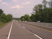
Much of the highway in both states is a two-lane road, running through narrow mountain valleys, but there are expressway portions. In Pennsylvania, one near Stroudsburg connects concurrencies
with PA 33
and Interstate 80
; in New York, the north end is an expressway.
, finally climbing a valley headwall
near Tower City
to intersect Interstate 81
on the other side, then continues on to Tremont
. Beyond that, the generally straight route starts to curve a little more frequently into Pottsville
, after which it follows the upper Schuylkill
as it heads into lightly populated coal mining
regions such as Port Carbon
, Cumbola, New Philadelphia
, and Middleport on its way to Tamaqua
.
 Several miles beyond, it crosses into Carbon County
at Lansford, where it nestles between Nesquehoning, Sharpe and Pisgah mountains until it finally turns slightly to the north just before Nesquehoning
. From there it follows the Nesquehoning Creek valley down to the Lehigh River
, which 209 follows southeasterly through Jim Thorpe
to Lehighton
, the largest community along the route so far. At the south end of the town, it crosses the river and resumes its north-trending eastward course, which brings it presently to an interchange at Interstate 476
, the Pennsylvania Turnpike
's northeast extension.
and eventually to its absorption into Route 33
. Business 209 leaves the road at Sciota for travelers wishing to bypass the expressway.
At the next exit, 209 takes its own short branch of expressway several miles to I-80 just outside Stroudsburg
. It stays with the interstate through the city and neighboring East Stroudsburg
, leaving to the north at one of the last exits before the state line.
From this point on, 209 runs much more northerly, reconnecting with Business 209 after several miles and taking its more firmly northeast bearing to eventually run along the Delaware River
shortly after entering Pike County
, its last in the state. This 20 miles (32.2 km) segment provides access to New Jersey
via toll bridges at Dingman's Bridge
and Milford Crossing
, where US 206
comes to its northern end. Just beyond the latter bridge, the road reaches the eponymous community
, where US 6
joins it.
 The two highways eventually start to run alongside Interstate 84
, and development picks up as they approach Matamoras
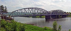
, the easternmost town in the state. After crossing under the interstate at its final Pennsylvania interchange, they form the borough's Main Street and cross into New York via the Mid-Delaware Bridge
.
, but after less than a mile 209 strikes out to the northeast again on its own. After leaving the city, it enters the valley between the Shawangunk Ridge
and the Catskill Plateau
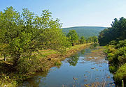
to its west, following the Neversink River
until crossing it just prior to the hamlet of Cuddebackville. While the scenery is often spectacular, the settlements along the road are few, with only one blinker between Port Jervis and the Sullivan County
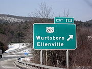
line. At Wurtsboro
, shortly after the NY 17
(future Interstate 86
) interchange, the first light is finally reached.
 The road follows along some of the old Delaware and Hudson Canal
, a National Historic Landmark
and passes Wurtsboro Airport, out of the county into Ulster County
, and eventually reaches another village, more bustling Ellenville
. Just past it, in the hamlet of Napanoch
, it picks up its first concurrency partner since route 6, NY 55
. These two routes run together as Rondout Creek
crosses and eventually runs alongside the road.
At another small hamlet, Kerhonkson
, 55 leaves to join US 44
at the latter's western terminus. 44 and 55 offer access ultimately to Poughkeepsie
, 30 miles (48.3 km) to the east. The valley begins to widen as another road, NY 213
, joins for a mile before leaving at a blinker in downtown Stone Ridge
. To the north, the road eventually widens into four lanes, then four divided lanes as the freeway begins just short of NY 28
just west of Kingston
, just inside the Catskill Park.
After turning to the east again, 209 crosses the New York State Thruway
but does not have an exit. The eastbound highway remains an expressway to the Kingston-Rhinecliff Bridge
. Route 209, however, does not make it that far, becoming NY 199
where it crosses over US 9W
.
in colonial times
and then the historic Delaware and Hudson Canal
in the early 19th century, keeps it in the scenic valley between the Catskill Plateau
and the Shawangunk Ridge
. Except for the expressway
at the northern end—the remnant of a much more ambitious plan to make the entire roadway one—US 209 remains a two-lane rural road for much of its length in the state. The small communities along it are separated by great distances, and the road is a vital access link.
carried several designations. On May 31, 1911, as part of the Sproul Road Bill, the highway was assigned several Legislative Route numbers, each corresponding to a specific section of what would become US 209. The segment of the route from Duncannon
north to Millersburg
was part of Legislative Route 1. From Millersburg east to Pottsville
, the highway was referenced as LR 199. Between Pottsville and Lehighton
, the road carried LR 162. The section connecting Lehighton to Stroudsburg
was given LR 164. Lastly, the segment from Stroudsburg to Milford
was designated LR 167. The future US 6 / US 209 concurrency between Milford and the state line carried LR 8.
The Pennsylvania portion of US 209 dates back to the formation of the U.S. Highway System in 1926. At the time, US 209 began at U.S. Route 11 (today US 22 / US 322
) east of Duncannon
and ended at U.S. Route 6 in Milford. Northeast of Milford, US 6 continued alone to Matamoras
and across the Delaware River
into New York
. Between Duncannon and Millersburg
, US 209 was routed along the eastern banks of the Susquehanna River
on what is now PA 147
. In the Poconos, US 209 ran along the modern U.S. Route 209 Business. US 209 was extended northward to Kingston, New York, ca. 1935, creating an overlap with US 6 from Milford to the state line. Meanwhile, US 209 was truncated by 1938 to end in Millersburg while the former routing of US 209 from Clarks Ferry to Millersburg became part of an extended U.S. Route 15.
 In the 1960s, the routing of US 209 was altered in the vicinity of Stroudsburg
. At what is now the interchange between US 209 and U.S. Route 209 Business, US 209 broke from its previous alignment and continued east to a newly-built freeway (modern PA 33
). PA 115
, which was concurrent with US 209 from Brodheadsville
to the freeway, continued south on the expressway while US 209 proceeded north. At the present-day split between PA 33 and US 209, US 209 followed the east fork, leaving the west fork with no designation. US 209 then followed its current alignment around Stroudsburg, running concurrent to Interstate 80 from exit 46A to exit 52 (now exits 304 and 309, respectively). It left I-80 at exit 52 and rejoined its previous alignment northeast of the borough. The old alignment through the borough was redesignated as US 209 Business. Part of US 209's new alignment east of Stroudsburg was previously part of PA 402
. By 1972, PA 115 was truncated to Brodheadsville and the length of the north–south freeway near Stroudsburg was designated PA 33, overlapping US 209 for roughly two miles.
The National Park Service began the rule of no trucks along the Delaware Water Gap National Recreation Area on US 209 in August 1983. The bill was passed by President Ronald Reagan
on the 1st of the month. It was projected to begin in April 1983, but the bill was delayed 180 days. In 1995, commercial vehicles began running in the area again, as long as they pay fee at two toll booths, one in Bushkill and one just south of downtown Milford. Prices began in 1995 and charged from $3.00 for 2-axles to $18.00 for 5 or more axles.
After rains from Hurricane Irene
in August and Tropical Storm Lee
in September, the grounds under the highway were saturated and after a landslide occurred on October 21, the National Park Service closed Route 209 between Route 739
in Dingmans Ferry and the North Contact Station just south of the Milford-Montague Bridge. Due to the approach of winter, the National Park Service can only get engineering done with outside contractors. The detour set in place takes motorists across the Dingmans Ferry Bridge and Old Mine Road
or via Route 739 and Route 2001
(Milford Road) to access Milford. Delaware Township has asked the Pennsylvania Department of Transportation
to keep Route 739 near Route 209 clear of snow, due to the importance of the intersection. However, Route 209 is slated to be closed through the winter and likely into summer of 2012.
has been plagued by traffic issues for over a decade. In 1990, studies were launched to investigate the possibility of constructing a bypass of the intersection, located in the hamlet
of Marshalls Creek
in Middle Smithfield Township
. Traffic at the junction had become large enough to cause the town to consider constructing a bypass in the area. The proposal for a bypass was passed in October 2004 and was projected to cost $70 million. The bypass will be 3.5 miles (5.6 km) in length and will have an asphalt
surface. There will be nine new signalized intersections: seven on US 209, one on PA 402, and one on River Road (SR 2028). The constructors expect that during the six-year project, traffic will remain the same on US 209, and no detours of PA 402 and US 209 are planned. The first of three phases of construction was completed in mid-2007 and cost $14.2 million. Phase two, projected to start in late 2007, is projected to cost $17 million.
to NY 10
(now US 9W
) in Kingston via Wurtsboro
and Napanoch
was designated as NY 50. In 1927, the first official route log published by AASHO included the NY 50 alignment as part of US 6
. A year later, AASHO modified the definition of US 6, placing the route along a new alignment further south in the state. In turn, the Port Jervis – Kingston highway was redesignated US 6N. The designation remained in place until 1933, when it was removed due to a conflict with another US 6N
in Pennsylvania
. The former US 6N was then redesignated as NY 279. Ca. 1935, the road changed designations for the final time, rejoining the U.S. Highway System and becoming part of an extended US 209.
 The portion of US 209 south of Kingston has remained virtually unchanged, with the exception of local realignments. Two such reroutings were in the vicinity of the hamlets of Spring Glen
and Napanoch
, where US 209 was initially routed on Phillipsport Road and Main Street, respectively. US 209 was realigned to bypass Napanoch ca. 1962, by which time construction had begun on a bypass of Spring Glen. It was opened to traffic by 1964.
US 209 initially entered Kingston on what is now Old Route 209 and Hurley Avenue. Within the city, the route followed North Front Street, and Clinton, Albany, and Ulster Avenues to a terminus at East Chester Street (US 9W). At the time, US 209 had an overlap with NY 32
from Broadway to Flatbush Avenue. Construction began in the early 1960s on a new limited-access highway bypassing downtown Kingston to the northwest. The highway began at US 209 south of Hurley
and ended at an interchange with US 9W north of Kingston and south of Lake Katrine
, where it met the western terminus of NY 199
. The new route was completed by 1964 and became a realignment of US 209.
of U.S. Route 209 in eastern Pennsylvania
. The southern terminus of the route is at US 209 in the Hamilton Township
hamlet of Sciota. The northern terminus is at US 209 in the Smithfield Township
hamlet of Marshalls Creek. US 209 Business is the lone auxiliary route of US 209 in Pennsylvania.
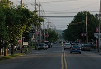
US 209 Business was US 209 until 1962 when US 209 was moved onto Interstate 80 between Marshalls Creek and present-day I-80 exit 305 in Stroudsburg
, allowing US 209 Business to occupy the former alignment of US 209. US 209 Business was extended southward to its current southern terminus in 1964 when US 209 was relocated onto a bypass paralleling its former alignment between Stroudsburg and Sciota.
Pennsylvania
The Commonwealth of Pennsylvania is a U.S. state that is located in the Northeastern and Mid-Atlantic regions of the United States. The state borders Delaware and Maryland to the south, West Virginia to the southwest, Ohio to the west, New York and Ontario, Canada, to the north, and New Jersey to...
and New York
New York
New York is a state in the Northeastern region of the United States. It is the nation's third most populous state. New York is bordered by New Jersey and Pennsylvania to the south, and by Connecticut, Massachusetts and Vermont to the east...
. Although the route is a spur of U.S. Route 9
U.S. Route 9
U.S. Route 9 is a north–south United States highway in the states of Delaware, New Jersey, and New York in the United States. It is one of only two U.S. highways with a ferry connection ; the other being US 10. US 9 is signed east–west in Delaware and north–south on the rest of...
, US 209 never intersects US 9, making the connection via U.S. Route 9W
U.S. Route 9W
U.S. Route 9W is a north–south U.S. Highway in the states of New Jersey and New York. It begins on Fletcher Avenue in Fort Lee, New Jersey as it crosses the US 1 & 9, US 46, and the Interstate 95 approaches to the George Washington Bridge, where it heads north up the west...
instead. The southern terminus of the route is at Pennsylvania Route 147
Pennsylvania Route 147
Pennsylvania Route 147 is a north–south route that runs for along the east shore of the Susquehanna River in central Pennsylvania, United States. The northern terminus is at an interchange with Interstate 80 and Interstate 180 in Turbot Township. The southern terminus is at an interchange...
in Millersburg, Pennsylvania
Millersburg, Pennsylvania
Millersburg is a borough in Dauphin County, Pennsylvania, United States. The population was 2,562 at the 2000 census. It is part of the Harrisburg–Carlisle Metropolitan Statistical Area.-Geography:...
. The northern terminus is at US 9W north of Kingston
Kingston, New York
Kingston is a city in and the county seat of Ulster County, New York, USA. It is north of New York City and south of Albany. It became New York's first capital in 1777, and was burned by the British Oct. 16, 1777, after the Battles of Saratoga...
in Ulster, New York
Ulster, New York
Ulster is a town in Ulster County, New York, United States. The population was 12,544 at the 2000 census.The Town of Ulster is in the northeast part of the county. The town is directly north of the City of Kingston. Ulster borders the Catskill Park....
, where the road continues east as New York State Route 199
New York State Route 199
New York State Route 199 is a state highway located in the Hudson Valley of New York in the United States. It extends for from an interchange with U.S. Route 9W and US 209 north of Kingston to an intersection with US 44 and NY 22 southwest of Millerton...
. US 209 is one of the original highways in the 1926 U.S. Highway System plan. In Pennsylvania
Pennsylvania
The Commonwealth of Pennsylvania is a U.S. state that is located in the Northeastern and Mid-Atlantic regions of the United States. The state borders Delaware and Maryland to the south, West Virginia to the southwest, Ohio to the west, New York and Ontario, Canada, to the north, and New Jersey to...
, the highway travels through the length of the Delaware Water Gap National Recreation Area
Delaware Water Gap National Recreation Area
Delaware Water Gap National Recreation Area, administered by the National Park Service, preserves almost of land along the Delaware River's New Jersey and Pennsylvania shores, stretching from the Delaware Water Gap northward almost to the New York state line...
. For part of its route in New York
New York
New York is a state in the Northeastern region of the United States. It is the nation's third most populous state. New York is bordered by New Jersey and Pennsylvania to the south, and by Connecticut, Massachusetts and Vermont to the east...
, US 209 runs alongside the defunct Delaware and Hudson Canal
Delaware and Hudson Canal
The Delaware and Hudson Canal was the first venture of the Delaware and Hudson Canal Company, which later developed the Delaware and Hudson Railway...
, which ran from Port Jervis
Port Jervis, New York
Port Jervis is a city on the Delaware River in western Orange County, New York, with a population of 8,860 at the 2000 census. The communities of Deerpark, Huguenot, Sparrowbush, and Greenville are adjacent to Port Jervis, and the towns of Montague, New Jersey and Matamoras, Pennsylvania face the...
to Kingston
Kingston, New York
Kingston is a city in and the county seat of Ulster County, New York, USA. It is north of New York City and south of Albany. It became New York's first capital in 1777, and was burned by the British Oct. 16, 1777, after the Battles of Saratoga...
.
US 209 was assigned as part of the establishment of the U.S. Highway System in 1926. The route was initially an intrastate highway contained entirely within the state of Pennsylvania
Pennsylvania
The Commonwealth of Pennsylvania is a U.S. state that is located in the Northeastern and Mid-Atlantic regions of the United States. The state borders Delaware and Maryland to the south, West Virginia to the southwest, Ohio to the west, New York and Ontario, Canada, to the north, and New Jersey to...
. It began at an intersection with U.S. Route 11 (now US 22 / US 322
U.S. Route 322
U.S. Route 322 is a long, east–west United States Highway, traversing Ohio, Pennsylvania, and New Jersey. The road is a spur of U.S. Route 22 and one of the original highways from 1926...
) in Clarks Ferry (east of Duncannon
Duncannon, Pennsylvania
Duncannon is a borough in Perry County, Pennsylvania, United States. The population was 1,508 at the 2000 census. It is part of the Harrisburg–Carlisle Metropolitan Statistical Area. The center of population of Pennsylvania is located in Duncannon. It is named after the coastal town of...
) and ended at U.S. Route 6 in Milford
Milford, Pennsylvania
Milford is a borough in Pike County, Pennsylvania, United States, and the county seat. Its population was 1,021 at the 2010 census. It was founded in 1796 by Judge John Biddis, one of the state's first four circuit judges, who named the settlement after his ancestral home in Wales.Milford has a...
. US 209 was extended northward to U.S. Route 9W
U.S. Route 9W
U.S. Route 9W is a north–south U.S. Highway in the states of New Jersey and New York. It begins on Fletcher Avenue in Fort Lee, New Jersey as it crosses the US 1 & 9, US 46, and the Interstate 95 approaches to the George Washington Bridge, where it heads north up the west...
in Kingston, New York ca. 1935 and truncated to Millersburg, Pennsylvania
Millersburg, Pennsylvania
Millersburg is a borough in Dauphin County, Pennsylvania, United States. The population was 2,562 at the 2000 census. It is part of the Harrisburg–Carlisle Metropolitan Statistical Area.-Geography:...
, by 1938. The portion of US 209 in New York north of Port Jervis
Port Jervis, New York
Port Jervis is a city on the Delaware River in western Orange County, New York, with a population of 8,860 at the 2000 census. The communities of Deerpark, Huguenot, Sparrowbush, and Greenville are adjacent to Port Jervis, and the towns of Montague, New Jersey and Matamoras, Pennsylvania face the...
was previously designated as US 6 from 1926 to 1928 and U.S. Route 6N from 1928 to 1933.
US 209 was realigned onto limited-access highways in two locations along its routing during the 1960s. In Kingston, New York, construction began on a highway bypassing downtown to the northwest in the early 1960s. The highway began at US 209 south of the city and ended at US 9W north of downtown Kingston. It opened to traffic as a realignment of US 209 by 1964. In Stroudsburg, Pennsylvania
Stroudsburg, Pennsylvania
Stroudsburg is a borough in Monroe County, Pennsylvania, United States. It is located in the Poconos region of the state, approximately five miles from the Delaware Water Gap, at the confluence of the Brodhead and Pocono Creeks. It is the county seat of Monroe County. Stroudsburg is part of the...
, US 209 was moved onto a pair of new expressways south and east of the borough in the 1960s. US 209's former routing into Stroudsburg was redesignated as U.S. Route 209 Business.
Route description
|-|PA || 150.60 || 242.37
|-
|NY || 61.14 || 98.40
|-
|Total || 211.74 || 340.76
|}
Although signed as a north–south route in both states for its entire length, 209 actually runs closer to east–west along its southern sections in Pennsylvania, only gently trending northward. Only at Stroudsburg
Stroudsburg, Pennsylvania
Stroudsburg is a borough in Monroe County, Pennsylvania, United States. It is located in the Poconos region of the state, approximately five miles from the Delaware Water Gap, at the confluence of the Brodhead and Pocono Creeks. It is the county seat of Monroe County. Stroudsburg is part of the...
does it begin to turn more to the north as it begins to follow the Delaware River
Delaware River
The Delaware River is a major river on the Atlantic coast of the United States.A Dutch expedition led by Henry Hudson in 1609 first mapped the river. The river was christened the South River in the New Netherland colony that followed, in contrast to the North River, as the Hudson River was then...
. In New York it runs almost due northeast for its entire length.
Much of the highway in both states is a two-lane road, running through narrow mountain valleys, but there are expressway portions. In Pennsylvania, one near Stroudsburg connects concurrencies
Concurrency (road)
A concurrency, overlap, or coincidence in a road network is an instance of one physical road bearing two or more different highway, motorway, or other route numbers...
with PA 33
Pennsylvania Route 33
Pennsylvania Route 33 is a -long limited-access state highway in eastern Pennsylvania, United States. South of the US 22 interchange, the route is called the Gen. Anthony Clement McAuliffe 101st Airborne Memorial Highway....
and Interstate 80
Interstate 80
Interstate 80 is the second-longest Interstate Highway in the United States, following Interstate 90. It is a transcontinental artery running from downtown San Francisco, California to Teaneck, New Jersey in the New York City Metropolitan Area...
; in New York, the north end is an expressway.
Millersburg to Jim Thorpe
From Millersburg, 209 runs alongside the Berry Mountain ridge into Schuylkill CountySchuylkill County, Pennsylvania
-Notable people:*Boxing heavyweight great Muhammad Ali had his training camp in Deer Lake.*Charles Justin Bailey, commanding general of the 81st Division in World War I, was born in Tamaqua on June 21, 1859....
, finally climbing a valley headwall
Headwall
In physical geography and geology the headwall of a glacial cirque is its highest cliff.In civil engineering, a headwall is a small retaining wall placed at the outlet of a stormwater pipe or culvert....
near Tower City
Tower City, Pennsylvania
Tower City is a borough in Schuylkill County, Pennsylvania, United States. The population was 1,396 at the 2000 census.-Geography:Tower City is located at ....
to intersect Interstate 81
Interstate 81
Interstate 81 is an Interstate Highway in the eastern part of the United States. Its southern terminus is at Interstate 40 in Dandridge, Tennessee; its northern terminus is on Wellesley Island at the Canadian border, where the Thousand Islands Bridge connects it to Highway 401, the main freeway...
on the other side, then continues on to Tremont
Tremont, Pennsylvania
Tremont is a borough in Schuylkill County, Pennsylvania, United States. The population was 1,784 at the 2000 census.-Geography:Tremont is located at ....
. Beyond that, the generally straight route starts to curve a little more frequently into Pottsville
Pottsville, Pennsylvania
Pottsville is the only city in and the county seat of Schuylkill County, Pennsylvania, United States. The population was 15,549 at the 2000 census. The city lies along the west bank of the Schuylkill River, north-west of Philadelphia...
, after which it follows the upper Schuylkill
Schuylkill River
The Schuylkill River is a river in Pennsylvania. It is a designated Pennsylvania Scenic River.The river is about long. Its watershed of about lies entirely within the state of Pennsylvania. The source of its eastern branch is in the Appalachian Mountains at Tuscarora Springs, near Tamaqua in...
as it heads into lightly populated coal mining
Coal mining
The goal of coal mining is to obtain coal from the ground. Coal is valued for its energy content, and since the 1880s has been widely used to generate electricity. Steel and cement industries use coal as a fuel for extraction of iron from iron ore and for cement production. In the United States,...
regions such as Port Carbon
Port Carbon, Pennsylvania
Port Carbon is a borough of Schuylkill County, Pennsylvania, two miles northeast of Pottsville, Pa. It is in a coal-mining area; in the past, ironworks had been a feature of the borough. In 1900, 2,168 people lived here; in 1910, 2,678 people were inhabitants of Port Carbon...
, Cumbola, New Philadelphia
New Philadelphia, Pennsylvania
New Philadelphia is a borough in Schuylkill County, Pennsylvania, United States. The population was 1,149 at the 2000 census.-Geography:New Philadelphia is located at , approximately northwest of the city of Philadelphia....
, and Middleport on its way to Tamaqua
Tamaqua, Pennsylvania
Tamaqua is a borough in eastern Schuylkill County, Pennsylvania, in the United States. The borough, located in Northeastern Pennsylvania's Coal Region, had a population of 7,107 as of the 2010 U.S...
.
Carbon County, Pennsylvania
As of the census of 2000, there were 58,802 people, 23,701 households, and 16,424 families residing in the county. The population density was 154 people per square mile . There were 30,492 housing units at an average density of 80 per square mile...
at Lansford, where it nestles between Nesquehoning, Sharpe and Pisgah mountains until it finally turns slightly to the north just before Nesquehoning
Nesquehoning, Pennsylvania
Nesquehoning is a borough in Carbon County, Pennsylvania, United States. The population was 3,288 at the 2000 census. The name is of Native American origin, commonly believed to signify "narrow valley;" however native language scholars translate the name as "at the black lick" or "at the dirty...
. From there it follows the Nesquehoning Creek valley down to the Lehigh River
Lehigh River
The Lehigh River, a tributary of the Delaware River, is a river located in eastern Pennsylvania, in the United States. Part of the Lehigh, along with a number of its tributaries, is designated a Pennsylvania Scenic River by the state's Department of Conservation and Natural Resources...
, which 209 follows southeasterly through Jim Thorpe
Jim Thorpe, Pennsylvania
Jim Thorpe is a borough in Carbon County, Pennsylvania, USA. The population was 4,804 at the 2000 census. It is the county seat of Carbon County. The town has been called the "Switzerland of America" due to the picturesque scenery, mountainous location, and architecture; as well as the "Gateway to...
to Lehighton
Lehighton, Pennsylvania
Lehighton is a borough in Carbon County, Pennsylvania, north by west of Philadelphia. In the past, it developed early industries because of water power from the Lehigh River. With the location of a repair facility here and its regional operations, the Lehigh Valley Railroad became for years a...
, the largest community along the route so far. At the south end of the town, it crosses the river and resumes its north-trending eastward course, which brings it presently to an interchange at Interstate 476
Interstate 476
Interstate 476 is a auxiliary Interstate Highway in the U.S. state of Pennsylvania designated between Interstate 95 near Chester and Interstate 81 near Scranton, serving as the primary north–south Interstate corridor through eastern Pennsylvania....
, the Pennsylvania Turnpike
Pennsylvania Turnpike
The Pennsylvania Turnpike is a toll highway system operated by the Pennsylvania Turnpike Commission in the Commonwealth of Pennsylvania, United States. The three sections of the turnpike system total . The main section extends from Ohio to New Jersey and is long...
's northeast extension.
Jim Thorpe to Matamoras
Once again, there are no major settlements along 209 as it heads through isolated valleys, this time with more agricultural use evident, into Monroe CountyMonroe County, Pennsylvania
-National protected areas:* Delaware Water Gap National Recreation Area * Middle Delaware National Scenic River -Demographics:As of the census of 2010, there are 176,567 people, 49,454 households, and 36,447 families residing in the county. The population density was 228 people per square mile...
and eventually to its absorption into Route 33
Pennsylvania Route 33
Pennsylvania Route 33 is a -long limited-access state highway in eastern Pennsylvania, United States. South of the US 22 interchange, the route is called the Gen. Anthony Clement McAuliffe 101st Airborne Memorial Highway....
. Business 209 leaves the road at Sciota for travelers wishing to bypass the expressway.
At the next exit, 209 takes its own short branch of expressway several miles to I-80 just outside Stroudsburg
Stroudsburg, Pennsylvania
Stroudsburg is a borough in Monroe County, Pennsylvania, United States. It is located in the Poconos region of the state, approximately five miles from the Delaware Water Gap, at the confluence of the Brodhead and Pocono Creeks. It is the county seat of Monroe County. Stroudsburg is part of the...
. It stays with the interstate through the city and neighboring East Stroudsburg
East Stroudsburg, Pennsylvania
East Stroudsburg is the most populous municipality in Monroe County, Pennsylvania, United States. It is located in the Poconos region of the state. Originally known as "Dansbury", East Stroudsburg was renamed for geographic reasons when the Delaware, Lackawanna, and Western Railroad opened a...
, leaving to the north at one of the last exits before the state line.
From this point on, 209 runs much more northerly, reconnecting with Business 209 after several miles and taking its more firmly northeast bearing to eventually run along the Delaware River
Delaware River
The Delaware River is a major river on the Atlantic coast of the United States.A Dutch expedition led by Henry Hudson in 1609 first mapped the river. The river was christened the South River in the New Netherland colony that followed, in contrast to the North River, as the Hudson River was then...
shortly after entering Pike County
Pike County, Pennsylvania
-National protected areas:* Delaware Water Gap National Recreation Area * Middle Delaware National Scenic River * Upper Delaware Scenic and Recreational River -Demographics:...
, its last in the state. This 20 miles (32.2 km) segment provides access to New Jersey
New Jersey
New Jersey is a state in the Northeastern and Middle Atlantic regions of the United States. , its population was 8,791,894. It is bordered on the north and east by the state of New York, on the southeast and south by the Atlantic Ocean, on the west by Pennsylvania and on the southwest by Delaware...
via toll bridges at Dingman's Bridge
Dingman's Ferry Bridge
The Dingman's Ferry Bridge is the last privately owned toll bridge on the Delaware River and one of the last few in the United States. It is owned and operated by the Dingmans Choice and Delaware Bridge Company.-Origins - Dingman's Ferry:...
and Milford Crossing
Milford-Montague Toll Bridge
The Milford–Montague Toll Bridge is a truss bridge crossing the Delaware River, connecting Montague Township, New Jersey to Milford, Pennsylvania on U.S. Route 206. The two-lane bridge, which opened on December 30, 1953, has a total length of 1,150 feet , and is operated by the Delaware River...
, where US 206
U.S. Route 206
U.S. Route 206 is a long north–south United States highway in New Jersey and Pennsylvania, United States. Only about a half a mile of its length is in Pennsylvania; the Milford-Montague Toll Bridge carries it over the Delaware River into New Jersey, where it is the remainder of the route...
comes to its northern end. Just beyond the latter bridge, the road reaches the eponymous community
Milford, Pennsylvania
Milford is a borough in Pike County, Pennsylvania, United States, and the county seat. Its population was 1,021 at the 2010 census. It was founded in 1796 by Judge John Biddis, one of the state's first four circuit judges, who named the settlement after his ancestral home in Wales.Milford has a...
, where US 6
U.S. Route 6 in Pennsylvania
U.S. Route 6 travels east–west near the north edge of the U.S. state of Pennsylvania from the Ohio state line near Pymatuning Reservoir east to the Mid-Delaware Bridge over the Delaware River into Port Jervis, New York. It is the longest highway segment in the Commonwealth. Most of it is a...
joins it.
Interstate 84 (east)
Interstate 84 is an Interstate Highway extending from Dunmore, Pennsylvania at an interchange with Interstate 81 to Sturbridge, Massachusetts, at an interchange with the Massachusetts Turnpike . I-84 has mile-log junction numbering in Pennsylvania; otherwise, exit numbers are roughly sequential...
, and development picks up as they approach Matamoras
Matamoras, Pennsylvania
Matamoras is a borough in Pike County, Pennsylvania, United States. The population was 2,469 at the 2010 census. It is the easternmost town in Pennsylvania.-History:...
, the easternmost town in the state. After crossing under the interstate at its final Pennsylvania interchange, they form the borough's Main Street and cross into New York via the Mid-Delaware Bridge
Mid-Delaware Bridge
The Mid-Delaware Bridge, sometimes known as the Port Jervis-Matamoras Bridge or the Fourth Barrett Bridge, is a continuous truss bridge which carries U.S. Routes 6 and 209 across that river between those two communities and thus the states of New York and Pennsylvania...
.
Mid-Delaware Bridge to Kingston
6 and 209 remain concurrent as they enter Port JervisPort Jervis, New York
Port Jervis is a city on the Delaware River in western Orange County, New York, with a population of 8,860 at the 2000 census. The communities of Deerpark, Huguenot, Sparrowbush, and Greenville are adjacent to Port Jervis, and the towns of Montague, New Jersey and Matamoras, Pennsylvania face the...
, but after less than a mile 209 strikes out to the northeast again on its own. After leaving the city, it enters the valley between the Shawangunk Ridge
Shawangunk Ridge
The Shawangunk Ridge , also known as the Shawangunk Mountains or The Gunks, is a ridge of bedrock in Ulster County, Sullivan County and Orange County in the state of New York, extending from the northernmost point of New Jersey to the Catskill Mountains.The ridgetop, which widens considerably at...
and the Catskill Plateau
Catskill Mountains
The Catskill Mountains, an area in New York State northwest of New York City and southwest of Albany, are a mature dissected plateau, an uplifted region that was subsequently eroded into sharp relief. They are an eastward continuation, and the highest representation, of the Allegheny Plateau...
to its west, following the Neversink River
Neversink River
The Neversink River is a tributary of the Delaware River in southeastern New York in the United States...
until crossing it just prior to the hamlet of Cuddebackville. While the scenery is often spectacular, the settlements along the road are few, with only one blinker between Port Jervis and the Sullivan County
Sullivan County, New York
Sullivan County is a county located in the U.S. state of New York. As of the 2010 census, the population was 77,547. The county seat is Monticello. The name is in honor of Major General John Sullivan, who was a hero in the American Revolutionary War...
line. At Wurtsboro
Wurtsboro, New York
Wurtsboro is a village located on U.S. Route 209 in the town of Mamakating in Sullivan County, New York, United States, near its junction with New York State Route 17...
, shortly after the NY 17
New York State Route 17
New York State Route 17 is a state highway that extends for through the Southern Tier and Downstate regions of New York in the United States...
(future Interstate 86
Interstate 86 (east)
Interstate 86 is an Interstate Highway that extends for through northwestern Pennsylvania and southern New York in the United States...
) interchange, the first light is finally reached.
Delaware and Hudson Canal
The Delaware and Hudson Canal was the first venture of the Delaware and Hudson Canal Company, which later developed the Delaware and Hudson Railway...
, a National Historic Landmark
National Historic Landmark
A National Historic Landmark is a building, site, structure, object, or district, that is officially recognized by the United States government for its historical significance...
and passes Wurtsboro Airport, out of the county into Ulster County
Ulster County, New York
Ulster County is a county located in the state of New York, USA. It sits in the state's Mid-Hudson Region of the Hudson Valley. As of the 2010 census, the population was 182,493. Recent population estimates completed by the United States Census Bureau for the 12-month period ending July 1 are at...
, and eventually reaches another village, more bustling Ellenville
Ellenville, New York
Ellenville is a village in Ulster County, New York, United States. The population was 4,135 at the 2010 census. The postal ZIP code is 12428. The telephone exchange is predominantly 647 and an overlaid 210 in the 845 area code.- Geography :...
. Just past it, in the hamlet of Napanoch
Napanoch, New York
Napanoch is a hamlet in Ulster County, New York. It is at the junction of routes 209 and 55. It is on the Shawangunk Ridge National Scenic Byway, and is part of the Hudson River Valley National Heritage Area....
, it picks up its first concurrency partner since route 6, NY 55
New York State Route 55
New York State Route 55 is a state highway in southern New York, running from the Pennsylvania state line at the Delaware River in Barryville to the Connecticut state line at Wingdale...
. These two routes run together as Rondout Creek
Rondout Creek
Rondout Creek is a tributary of the Hudson River in Ulster and Sullivan counties, New York, USA. It rises on Rocky Mountain in the eastern Catskills, flows south into Rondout Reservoir, part of New York City's water supply network, then into the valley between the Catskills and the Shawangunk...
crosses and eventually runs alongside the road.
At another small hamlet, Kerhonkson
Kerhonkson, New York
Kerhonkson is a hamlet in Ulster County, New York, United States. The population was 1,684 at the 2010 census.Kerhonkson is a small hamlet which, along with Accord, makes up the Town of Rochester on US 209, just south of the town's boundary with the Town of Wawarsing and just north of where US 44...
, 55 leaves to join US 44
U.S. Route 44
U.S. Route 44 is an east–west United States highway that runs for 237 miles through four states in the Northeastern region of the United States. The western terminus is at U.S. Route 209 and New York State Route 55 in Kerhonkson, a hamlet in the Hudson Valley region of New York...
at the latter's western terminus. 44 and 55 offer access ultimately to Poughkeepsie
Poughkeepsie (city), New York
Poughkeepsie is a city in the state of New York, United States, which serves as the county seat of Dutchess County. Poughkeepsie is located in the Hudson River Valley midway between New York City and Albany...
, 30 miles (48.3 km) to the east. The valley begins to widen as another road, NY 213
New York State Route 213
New York State Route 213 is a state highway located entirely in Ulster County. It runs from the eastern Catskills to downtown Kingston....
, joins for a mile before leaving at a blinker in downtown Stone Ridge
Stone Ridge, New York
Stone Ridge is a hamlet in Ulster County, New York, United States. The population was 1,173 at the 2000 census.Stone Ridge is located in the Town of Marbletown, along US 209 where it overlaps NY 213.-Geography:...
. To the north, the road eventually widens into four lanes, then four divided lanes as the freeway begins just short of NY 28
New York State Route 28
New York State Route 28 is a state highway extending for in the shape of a "C" between the Hudson Valley city of Kingston and southern Warren County in the U.S. state of New York. Along the way, it intersects several major routes, including Interstate 88 , U.S. Route 20 , and the...
just west of Kingston
Kingston, New York
Kingston is a city in and the county seat of Ulster County, New York, USA. It is north of New York City and south of Albany. It became New York's first capital in 1777, and was burned by the British Oct. 16, 1777, after the Battles of Saratoga...
, just inside the Catskill Park.
After turning to the east again, 209 crosses the New York State Thruway
New York State Thruway
The New York State Thruway is a system of limited-access highways located within the state of New York in the United States. The system, known officially as the Governor Thomas E. Dewey Thruway for former New York Governor Thomas E. Dewey, is operated by the New York State Thruway Authority and...
but does not have an exit. The eastbound highway remains an expressway to the Kingston-Rhinecliff Bridge
Kingston-Rhinecliff Bridge
The Kingston–Rhinecliff Bridge is a continuous under-deck truss bridge that carries NY 199 across the Hudson River in New York State north of the City of Kingston and the hamlet of Rhinecliff. It was opened to traffic on February 2, 1957 as a two-lane bridge, although it was not actually...
. Route 209, however, does not make it that far, becoming NY 199
New York State Route 199
New York State Route 199 is a state highway located in the Hudson Valley of New York in the United States. It extends for from an interchange with U.S. Route 9W and US 209 north of Kingston to an intersection with US 44 and NY 22 southwest of Millerton...
where it crosses over US 9W
U.S. Route 9W
U.S. Route 9W is a north–south U.S. Highway in the states of New Jersey and New York. It begins on Fletcher Avenue in Fort Lee, New Jersey as it crosses the US 1 & 9, US 46, and the Interstate 95 approaches to the George Washington Bridge, where it heads north up the west...
.
History
US 209 follows a straight, northeasterly course for almost its entire length within New York. This corridor, first used for long-distance transport by the Old Mine RoadOld Mine Road
Old Mine Road is a road in New Jersey and New York said to be one of the oldest continuously-used roads in the United States of America. At a length of 104 miles, it stretches from the Delaware Water Gap National Recreation Area to the vicinity of Kingston, New York.Among the theories regarding the...
in colonial times
Colonial America
The colonial history of the United States covers the history from the start of European settlement and especially the history of the thirteen colonies of Britain until they declared independence in 1776. In the late 16th century, England, France, Spain and the Netherlands launched major...
and then the historic Delaware and Hudson Canal
Delaware and Hudson Canal
The Delaware and Hudson Canal was the first venture of the Delaware and Hudson Canal Company, which later developed the Delaware and Hudson Railway...
in the early 19th century, keeps it in the scenic valley between the Catskill Plateau
Catskill Mountains
The Catskill Mountains, an area in New York State northwest of New York City and southwest of Albany, are a mature dissected plateau, an uplifted region that was subsequently eroded into sharp relief. They are an eastward continuation, and the highest representation, of the Allegheny Plateau...
and the Shawangunk Ridge
Shawangunk Ridge
The Shawangunk Ridge , also known as the Shawangunk Mountains or The Gunks, is a ridge of bedrock in Ulster County, Sullivan County and Orange County in the state of New York, extending from the northernmost point of New Jersey to the Catskill Mountains.The ridgetop, which widens considerably at...
. Except for the expressway
Limited-access road
A limited-access road known by various terms worldwide, including limited-access highway, dual-carriageway and expressway, is a highway or arterial road for high-speed traffic which has many or most characteristics of a controlled-access highway , including limited or no access to adjacent...
at the northern end—the remnant of a much more ambitious plan to make the entire roadway one—US 209 remains a two-lane rural road for much of its length in the state. The small communities along it are separated by great distances, and the road is a vital access link.
Pennsylvania
Before the advent of the U.S. Highway System, the alignment of US 209 in PennsylvaniaPennsylvania
The Commonwealth of Pennsylvania is a U.S. state that is located in the Northeastern and Mid-Atlantic regions of the United States. The state borders Delaware and Maryland to the south, West Virginia to the southwest, Ohio to the west, New York and Ontario, Canada, to the north, and New Jersey to...
carried several designations. On May 31, 1911, as part of the Sproul Road Bill, the highway was assigned several Legislative Route numbers, each corresponding to a specific section of what would become US 209. The segment of the route from Duncannon
Duncannon, Pennsylvania
Duncannon is a borough in Perry County, Pennsylvania, United States. The population was 1,508 at the 2000 census. It is part of the Harrisburg–Carlisle Metropolitan Statistical Area. The center of population of Pennsylvania is located in Duncannon. It is named after the coastal town of...
north to Millersburg
Millersburg, Pennsylvania
Millersburg is a borough in Dauphin County, Pennsylvania, United States. The population was 2,562 at the 2000 census. It is part of the Harrisburg–Carlisle Metropolitan Statistical Area.-Geography:...
was part of Legislative Route 1. From Millersburg east to Pottsville
Pottsville, Pennsylvania
Pottsville is the only city in and the county seat of Schuylkill County, Pennsylvania, United States. The population was 15,549 at the 2000 census. The city lies along the west bank of the Schuylkill River, north-west of Philadelphia...
, the highway was referenced as LR 199. Between Pottsville and Lehighton
Lehighton, Pennsylvania
Lehighton is a borough in Carbon County, Pennsylvania, north by west of Philadelphia. In the past, it developed early industries because of water power from the Lehigh River. With the location of a repair facility here and its regional operations, the Lehigh Valley Railroad became for years a...
, the road carried LR 162. The section connecting Lehighton to Stroudsburg
Stroudsburg, Pennsylvania
Stroudsburg is a borough in Monroe County, Pennsylvania, United States. It is located in the Poconos region of the state, approximately five miles from the Delaware Water Gap, at the confluence of the Brodhead and Pocono Creeks. It is the county seat of Monroe County. Stroudsburg is part of the...
was given LR 164. Lastly, the segment from Stroudsburg to Milford
Milford, Pennsylvania
Milford is a borough in Pike County, Pennsylvania, United States, and the county seat. Its population was 1,021 at the 2010 census. It was founded in 1796 by Judge John Biddis, one of the state's first four circuit judges, who named the settlement after his ancestral home in Wales.Milford has a...
was designated LR 167. The future US 6 / US 209 concurrency between Milford and the state line carried LR 8.
The Pennsylvania portion of US 209 dates back to the formation of the U.S. Highway System in 1926. At the time, US 209 began at U.S. Route 11 (today US 22 / US 322
U.S. Route 322
U.S. Route 322 is a long, east–west United States Highway, traversing Ohio, Pennsylvania, and New Jersey. The road is a spur of U.S. Route 22 and one of the original highways from 1926...
) east of Duncannon
Duncannon, Pennsylvania
Duncannon is a borough in Perry County, Pennsylvania, United States. The population was 1,508 at the 2000 census. It is part of the Harrisburg–Carlisle Metropolitan Statistical Area. The center of population of Pennsylvania is located in Duncannon. It is named after the coastal town of...
and ended at U.S. Route 6 in Milford. Northeast of Milford, US 6 continued alone to Matamoras
Matamoras, Pennsylvania
Matamoras is a borough in Pike County, Pennsylvania, United States. The population was 2,469 at the 2010 census. It is the easternmost town in Pennsylvania.-History:...
and across the Delaware River
Delaware River
The Delaware River is a major river on the Atlantic coast of the United States.A Dutch expedition led by Henry Hudson in 1609 first mapped the river. The river was christened the South River in the New Netherland colony that followed, in contrast to the North River, as the Hudson River was then...
into New York
New York
New York is a state in the Northeastern region of the United States. It is the nation's third most populous state. New York is bordered by New Jersey and Pennsylvania to the south, and by Connecticut, Massachusetts and Vermont to the east...
. Between Duncannon and Millersburg
Millersburg, Pennsylvania
Millersburg is a borough in Dauphin County, Pennsylvania, United States. The population was 2,562 at the 2000 census. It is part of the Harrisburg–Carlisle Metropolitan Statistical Area.-Geography:...
, US 209 was routed along the eastern banks of the Susquehanna River
Susquehanna River
The Susquehanna River is a river located in the northeastern United States. At long, it is the longest river on the American east coast that drains into the Atlantic Ocean, and with its watershed it is the 16th largest river in the United States, and the longest river in the continental United...
on what is now PA 147
Pennsylvania Route 147
Pennsylvania Route 147 is a north–south route that runs for along the east shore of the Susquehanna River in central Pennsylvania, United States. The northern terminus is at an interchange with Interstate 80 and Interstate 180 in Turbot Township. The southern terminus is at an interchange...
. In the Poconos, US 209 ran along the modern U.S. Route 209 Business. US 209 was extended northward to Kingston, New York, ca. 1935, creating an overlap with US 6 from Milford to the state line. Meanwhile, US 209 was truncated by 1938 to end in Millersburg while the former routing of US 209 from Clarks Ferry to Millersburg became part of an extended U.S. Route 15.
Stroudsburg, Pennsylvania
Stroudsburg is a borough in Monroe County, Pennsylvania, United States. It is located in the Poconos region of the state, approximately five miles from the Delaware Water Gap, at the confluence of the Brodhead and Pocono Creeks. It is the county seat of Monroe County. Stroudsburg is part of the...
. At what is now the interchange between US 209 and U.S. Route 209 Business, US 209 broke from its previous alignment and continued east to a newly-built freeway (modern PA 33
Pennsylvania Route 33
Pennsylvania Route 33 is a -long limited-access state highway in eastern Pennsylvania, United States. South of the US 22 interchange, the route is called the Gen. Anthony Clement McAuliffe 101st Airborne Memorial Highway....
). PA 115
Pennsylvania Route 115
Pennsylvania Route 115 is a north–south state highway in eastern Pennsylvania. It stretches from U.S. Route 209 in Brodheadsville to Interstate 81 and Pennsylvania Route 309 near Wilkes-Barre. The road originated as the Sullivan Trail which later became known as the Easton and Wilkes-Barre...
, which was concurrent with US 209 from Brodheadsville
Brodheadsville, Pennsylvania
Brodheadsville is a census-designated place in Monroe County, Pennsylvania, United States. The population was 1,637 at the 2000 census. The community is served by Pleasant Valley School District.-Geography:...
to the freeway, continued south on the expressway while US 209 proceeded north. At the present-day split between PA 33 and US 209, US 209 followed the east fork, leaving the west fork with no designation. US 209 then followed its current alignment around Stroudsburg, running concurrent to Interstate 80 from exit 46A to exit 52 (now exits 304 and 309, respectively). It left I-80 at exit 52 and rejoined its previous alignment northeast of the borough. The old alignment through the borough was redesignated as US 209 Business. Part of US 209's new alignment east of Stroudsburg was previously part of PA 402
Pennsylvania Route 402
Pennsylvania Route 402 is a north–south state route in the Pennsylvania counties of Pike and Monroe. The southern terminus of the route is at U.S. Route 209 in the Smithfield Township village of Marshalls Creek. The northern terminus is at U.S. Route 6 in Blooming Grove Township...
. By 1972, PA 115 was truncated to Brodheadsville and the length of the north–south freeway near Stroudsburg was designated PA 33, overlapping US 209 for roughly two miles.
The National Park Service began the rule of no trucks along the Delaware Water Gap National Recreation Area on US 209 in August 1983. The bill was passed by President Ronald Reagan
Ronald Reagan
Ronald Wilson Reagan was the 40th President of the United States , the 33rd Governor of California and, prior to that, a radio, film and television actor....
on the 1st of the month. It was projected to begin in April 1983, but the bill was delayed 180 days. In 1995, commercial vehicles began running in the area again, as long as they pay fee at two toll booths, one in Bushkill and one just south of downtown Milford. Prices began in 1995 and charged from $3.00 for 2-axles to $18.00 for 5 or more axles.
After rains from Hurricane Irene
Hurricane Irene (2011)
Hurricane Irene was a large and powerful Atlantic hurricane that left extensive flood and wind damage along its path through the Caribbean, the United States East Coast and as far north as Atlantic Canada in 2011...
in August and Tropical Storm Lee
Tropical Storm Lee (2011)
Tropical Storm Lee was the twelfth named storm and thirteenth system overall of the 2011 Atlantic hurricane season, developing from a broad tropical disturbance over the Gulf on September 1. It was designated as Tropical Storm Lee the next day...
in September, the grounds under the highway were saturated and after a landslide occurred on October 21, the National Park Service closed Route 209 between Route 739
Pennsylvania Route 739
Pennsylvania Route 739 is a Pennsylvania highway contained entirely within Pike County, Pennsylvania. It was signed in 1967, and runs for almost . Its northern terminus is at U.S. Route 6 in Blooming Grove, running south to U.S. Route 209 in Delaware Township...
in Dingmans Ferry and the North Contact Station just south of the Milford-Montague Bridge. Due to the approach of winter, the National Park Service can only get engineering done with outside contractors. The detour set in place takes motorists across the Dingmans Ferry Bridge and Old Mine Road
Old Mine Road
Old Mine Road is a road in New Jersey and New York said to be one of the oldest continuously-used roads in the United States of America. At a length of 104 miles, it stretches from the Delaware Water Gap National Recreation Area to the vicinity of Kingston, New York.Among the theories regarding the...
or via Route 739 and Route 2001
State Route 2001 (Pike County, Pennsylvania)
State Quadrant Route 2001 in Pike County, Pennsylvania is a road in Dingman, Lehman, Delaware and Milford Townships. Formerly Pennsylvania Route 962 in part, the road stretches from U.S. Route 209 in Lehman Township to West Harford Street in downtown Milford...
(Milford Road) to access Milford. Delaware Township has asked the Pennsylvania Department of Transportation
Pennsylvania Department of Transportation
The Pennsylvania Department of Transportation oversees transportation issues in the Commonwealth of Pennsylvania. The administrator of PennDOT is the Pennsylvania Secretary of Transportation, currently Barry Schoch Presently, PennDOT supports over of state roads and highways, about 25,000...
to keep Route 739 near Route 209 clear of snow, due to the importance of the intersection. However, Route 209 is slated to be closed through the winter and likely into summer of 2012.
Marshalls Creek Bypass
The area where US 209 intersects PA 402Pennsylvania Route 402
Pennsylvania Route 402 is a north–south state route in the Pennsylvania counties of Pike and Monroe. The southern terminus of the route is at U.S. Route 209 in the Smithfield Township village of Marshalls Creek. The northern terminus is at U.S. Route 6 in Blooming Grove Township...
has been plagued by traffic issues for over a decade. In 1990, studies were launched to investigate the possibility of constructing a bypass of the intersection, located in the hamlet
Hamlet (place)
A hamlet is usually a rural settlement which is too small to be considered a village, though sometimes the word is used for a different sort of community. Historically, when a hamlet became large enough to justify building a church, it was then classified as a village...
of Marshalls Creek
Marshalls Creek, Pennsylvania
Marshalls Creek is an unincorporated community in Monroe County, Pennsylvania, United States....
in Middle Smithfield Township
Middle Smithfield Township, Pennsylvania
Middle Smithfield Township is a township in Monroe County, Pennsylvania, United States. The population was 11,495 at the 2000 census. 2008 population estimates by the United States Census Bureau place the population at 14,900.-Geography:...
. Traffic at the junction had become large enough to cause the town to consider constructing a bypass in the area. The proposal for a bypass was passed in October 2004 and was projected to cost $70 million. The bypass will be 3.5 miles (5.6 km) in length and will have an asphalt
Asphalt
Asphalt or , also known as bitumen, is a sticky, black and highly viscous liquid or semi-solid that is present in most crude petroleums and in some natural deposits, it is a substance classed as a pitch...
surface. There will be nine new signalized intersections: seven on US 209, one on PA 402, and one on River Road (SR 2028). The constructors expect that during the six-year project, traffic will remain the same on US 209, and no detours of PA 402 and US 209 are planned. The first of three phases of construction was completed in mid-2007 and cost $14.2 million. Phase two, projected to start in late 2007, is projected to cost $17 million.
New York
In the mid-1920s, a highway connecting Pennsylvania Route 7 at Port JervisPort Jervis, New York
Port Jervis is a city on the Delaware River in western Orange County, New York, with a population of 8,860 at the 2000 census. The communities of Deerpark, Huguenot, Sparrowbush, and Greenville are adjacent to Port Jervis, and the towns of Montague, New Jersey and Matamoras, Pennsylvania face the...
to NY 10
New York State Route 10
New York State Route 10 is a north–south state highway in the Central New York and North Country regions of New York in the United States. It extends for from the Quickway in Deposit, Delaware County to NY 8 at Higgins Bay, a hamlet in the Hamilton County town of Arietta...
(now US 9W
U.S. Route 9W
U.S. Route 9W is a north–south U.S. Highway in the states of New Jersey and New York. It begins on Fletcher Avenue in Fort Lee, New Jersey as it crosses the US 1 & 9, US 46, and the Interstate 95 approaches to the George Washington Bridge, where it heads north up the west...
) in Kingston via Wurtsboro
Wurtsboro, New York
Wurtsboro is a village located on U.S. Route 209 in the town of Mamakating in Sullivan County, New York, United States, near its junction with New York State Route 17...
and Napanoch
Napanoch, New York
Napanoch is a hamlet in Ulster County, New York. It is at the junction of routes 209 and 55. It is on the Shawangunk Ridge National Scenic Byway, and is part of the Hudson River Valley National Heritage Area....
was designated as NY 50. In 1927, the first official route log published by AASHO included the NY 50 alignment as part of US 6
U.S. Route 6 in New York
U.S. Route 6 is a part of the U.S. Highway System that runs from Bishop, California, to Provincetown, Massachusetts. In New York, US 6 extends from the Pennsylvania state line at Port Jervis to the Connecticut state line east of Brewster...
. A year later, AASHO modified the definition of US 6, placing the route along a new alignment further south in the state. In turn, the Port Jervis – Kingston highway was redesignated US 6N. The designation remained in place until 1933, when it was removed due to a conflict with another US 6N
U.S. Route 6N
U.S. Route 6N is a long auxiliary route of U.S. Route 6 located in Erie County, Pennsylvania. The western terminus is at U.S. Route 20 in West Springfield a half-mile north of Interstate 90 exit 3. Its eastern terminus is at U.S. Route 6 and U.S...
in Pennsylvania
Pennsylvania
The Commonwealth of Pennsylvania is a U.S. state that is located in the Northeastern and Mid-Atlantic regions of the United States. The state borders Delaware and Maryland to the south, West Virginia to the southwest, Ohio to the west, New York and Ontario, Canada, to the north, and New Jersey to...
. The former US 6N was then redesignated as NY 279. Ca. 1935, the road changed designations for the final time, rejoining the U.S. Highway System and becoming part of an extended US 209.
Spring Glen, New York
Spring Glen is an unincorporated hamlet of the Town of Wawarsing in Ulster County, New York, United States. It is located just off US 209 just north of the Sullivan County line. It has the ZIP Code 12483....
and Napanoch
Napanoch, New York
Napanoch is a hamlet in Ulster County, New York. It is at the junction of routes 209 and 55. It is on the Shawangunk Ridge National Scenic Byway, and is part of the Hudson River Valley National Heritage Area....
, where US 209 was initially routed on Phillipsport Road and Main Street, respectively. US 209 was realigned to bypass Napanoch ca. 1962, by which time construction had begun on a bypass of Spring Glen. It was opened to traffic by 1964.
US 209 initially entered Kingston on what is now Old Route 209 and Hurley Avenue. Within the city, the route followed North Front Street, and Clinton, Albany, and Ulster Avenues to a terminus at East Chester Street (US 9W). At the time, US 209 had an overlap with NY 32
New York State Route 32
New York State Route 32 is a north–south state highway that extends for through the Hudson Valley and Capital District regions of the U.S. state of New York. It is a two-lane surface road for nearly its entire length, with few divided and no limited-access sections. From Harriman to Albany,...
from Broadway to Flatbush Avenue. Construction began in the early 1960s on a new limited-access highway bypassing downtown Kingston to the northwest. The highway began at US 209 south of Hurley
Hurley (CDP), New York
Hurley is a hamlet in the Town of Hurley, Ulster County, New York, USA. The population was 3,458 at the 2010 census....
and ended at an interchange with US 9W north of Kingston and south of Lake Katrine
Lake Katrine, New York
Lake Katrine is a hamlet Lake Katrine is a hamlet Lake Katrine is a hamlet (and census-designated place (CDP) in Ulster County, New York, United States. The population was 2,396 at the 2000 census....
, where it met the western terminus of NY 199
New York State Route 199
New York State Route 199 is a state highway located in the Hudson Valley of New York in the United States. It extends for from an interchange with U.S. Route 9W and US 209 north of Kingston to an intersection with US 44 and NY 22 southwest of Millerton...
. The new route was completed by 1964 and became a realignment of US 209.
Major intersections
US 209 Business
U.S. Route 209 Business is a business routeBusiness route
A business route in the United States and Canada is a short special route connected to a parent numbered highway at its beginning, then routed through the central business district of a nearby city or town, and finally reconnecting with the same parent numbered highway again at its...
of U.S. Route 209 in eastern Pennsylvania
Pennsylvania
The Commonwealth of Pennsylvania is a U.S. state that is located in the Northeastern and Mid-Atlantic regions of the United States. The state borders Delaware and Maryland to the south, West Virginia to the southwest, Ohio to the west, New York and Ontario, Canada, to the north, and New Jersey to...
. The southern terminus of the route is at US 209 in the Hamilton Township
Hamilton Township, Monroe County, Pennsylvania
Hamilton Township is a township in Monroe County, Pennsylvania, United States. The population was 8,235 at the 2000 census.-Geography:According to the United States Census Bureau, the township has a total area of , of which, of it is land and of it is water...
hamlet of Sciota. The northern terminus is at US 209 in the Smithfield Township
Smithfield Township, Monroe County, Pennsylvania
Smithfield Township is a township in Monroe County, Pennsylvania, United States. The population was 5,672 at the 2000 census.-Geography:According to the United States Census Bureau, the township has a total area of 23.9 square miles , of which, 23.2 square miles of it is land and...
hamlet of Marshalls Creek. US 209 Business is the lone auxiliary route of US 209 in Pennsylvania.
US 209 Business was US 209 until 1962 when US 209 was moved onto Interstate 80 between Marshalls Creek and present-day I-80 exit 305 in Stroudsburg
Stroudsburg, Pennsylvania
Stroudsburg is a borough in Monroe County, Pennsylvania, United States. It is located in the Poconos region of the state, approximately five miles from the Delaware Water Gap, at the confluence of the Brodhead and Pocono Creeks. It is the county seat of Monroe County. Stroudsburg is part of the...
, allowing US 209 Business to occupy the former alignment of US 209. US 209 Business was extended southward to its current southern terminus in 1964 when US 209 was relocated onto a bypass paralleling its former alignment between Stroudsburg and Sciota.