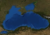
|
|
|
|
Black Sea
|
| |
|
| |
The Black Sea is an inland sea bounded by southeastern Europe, the Caucasus and the Anatolian peninsula (Turkey) and is ultimately connected to the Atlantic Ocean via the Mediterranean and Aegean Seas and various straits. The Bosporus strait connects it to the Sea of Marmara, and the strait of the Dardanelles connects it to the Aegean Sea region of the Mediterranean. These waters separate eastern Europe and western Asia. The Black Sea also connects to the Sea of Azov by the Strait of Kerch.
The Black Sea has an area of , a maximum depth of , and a volume of 547,000 km³ (133,500 cu mi).

Discussion
Ask a question about 'Black Sea'
Start a new discussion about 'Black Sea'
Answer questions from other users
|
Timeline

Encyclopedia
The Black Sea is an inland sea bounded by southeastern Europe, the Caucasus and the Anatolian peninsula (Turkey) and is ultimately connected to the Atlantic Ocean via the Mediterranean and Aegean Seas and various straits. The Bosporus strait connects it to the Sea of Marmara, and the strait of the Dardanelles connects it to the Aegean Sea region of the Mediterranean. These waters separate eastern Europe and western Asia. The Black Sea also connects to the Sea of Azov by the Strait of Kerch.
The Black Sea has an area of , a maximum depth of , and a volume of 547,000 km³ (133,500 cu mi). The Black Sea forms in an east-west trending elliptical depression which lies between Bulgaria, Georgia, Romania, Russia, Turkey, and Ukraine. It is constrained by the Pontic mountain range to the south, the Caucasus mountain range to the east and features a wide shelf to the north-west. The longest east-west extent is about 1175 km.
Important cities along the coast include: Constanta (306,000 with a metropolitan area of 550,000), Istanbul (11,372,613), Odessa (1,001,000), Mangalia (41,153), Burgas (229,250), Varna (357,752 with a metropolitan area of 716,500), Kherson (358,000), Sevastopol (379,200), Yalta (80,552), Kerch (158,165), Novorossiysk (281,400), Sochi (328,809), Sukhumi (43,700), Navodari (34,669), Poti (47,149), Batumi (121,806), Trabzon (275,137), Samsun (439,000) Ordu (190,143) and Zonguldak (104,276).
The Black Sea has a positive water balance, which results in a net outflow of water 300 km³ per year through the Bosphorus into the Aegean Sea (part of the Mediterranean Sea). Mediterranean water flows into the Black Sea as part of a 2-way hydrological exchange. The Black Sea outflow is less salinated and cool, therefore floats over the warm, relatively more salinated Mediterranean inflow. The Black Sea also receives river water from large Eurasian fluvial systems to the north of the Sea, of which the Don, Dnieper and Danube are the most significant.
In the past, the water level has varied significantly. Depending on the water level in the basin, more or less of the surrounding shelf and associated aprons are aerially exposed. At certain critical depths, it is possible for connections with surrounding water bodies to become established. It is through the most active of these connective routes, the Turkish Straits System (TSS), that the Black Sea joins the global ocean system. When this hydrological link is not present, the Black Sea is a lake, operating independently of the global ocean system. Currently the Black Sea water level is relatively high, thus water is being exchanged with the Mediterranean. The TSS connects the Black and Aegean Seas and comprises the Strait of Bosphorus Strait (Strait of Istanbul), the Marmara sea and the Strait of Dardanelles (Strait of Canakkale). The Black Sea also connects to the Sea of Azov via the Strait of Kerch
Name Modern names of the Sea are equivalents of the English name, "Black Sea", including ,Greek Mavri Thalassa (?a??? T??assa), Bulgarian Cherno more (????? ????), Georgian Shavi zghva (???? ????), Laz Ucha Zuga, or simply Zuga 'Sea', Romanian Marea Neagra, Russian Chornoye more (?????? ????), Turkish Karadeniz, Ukrainian Chorne more (????? ????), Ubykh . This name cannot be traced to an earlier date than the twelfth century, but there are indications that it may be considerably older.
The reason for this color term may be an ancient assignment of colors to the direction of the compass — black referring to the north, red referring to the south, and yellow to the east. Herodotus on one occasion uses Red Sea and Southern Sea interchangeably. A somewhat similar view shows the Turkish name: 'Kara (Black)' and 'Ak (White)' are respectively used to denote 'North' and 'South' in Medieval Turkish, as in Akhun Empire, Akkoyunlu and Karakoyunlu Empires, and Akdeniz (lit., 'White Sea', referring to the Mediterranean which lies south of the Medieval Turkish settlements. Another possible explanation comes from the colour of the Black Sea's deep waters. Being further north than the Mediterranean Sea and much less saline, the microalgae concentration is much richer, causing the dark colour. Visibility in the Black Sea is on average approximately five meters (5.5 yd), as compared to up to thirty-five meters (38 yd) in the Mediterranean.
Historical names: Strabo's Geography (1.2.10) reports that in antiquity, the Black Sea was often just called "the Sea" (ho pontos). For the most part, Graeco-Roman tradition refers to the Black Sea as the 'Hospitable sea', Euxeinos Pontos . This is a euphemism replacing an earlier 'Inhospitable Sea', Pontos Axeinos, first attested in Pindar (early fifth century BCE,~475 BC). Strabo (7.3.6) thinks that the Black Sea was called "inhospitable" before Greek colonization because it was difficult to navigate, and because its shores were inhabited by savage tribes; and that the name was changed to "hospitable" after the Milesians had colonized, making it part of Greek civilization. It is also possible that the name Axeinos arose by popular etymology from a Scythian Iranic axaina- 'unlit,' 'dark'; the designation "Black Sea" may thus date from Antiquity.
One Bulgarian understanding of the name is that the sea used to be quite stormy. Some sources stipulate that it goes back to the time of Noah's Ark. The Black Sea deluge theory is based on that idea.
In naval science, the Black Sea is thought to have received its name because of its hydrogen sulfide layer that begins about 200 meters below the surface, and supports a unique microbial population which produces black sediments probably due to anaerobic methane oxidation.
Geology and bathymetry
The geological origins of the basin can be traced back to two distinct relict back-arc basins which were initiated by to the splitting of an Albian volcanic arc and the subduction of both the Paleo-and Neo-Tethys Oceans, but the timings of these events remain controversial. Since its initiation, compressional tectonic environments led to subsidence in the basin, interspersed with extensional phases resulting in large-scale volcanism and numerous orogenies, causing the uplift of the Greater Caucasus, Pontides, Southern Crimea and Balkanides mountain ranges. The ongoing collision between the Eurasian and African plates and westward escape of the Anatolian block along the North Anatolian Fault and East Anatolian Faults dictates the current tectonic regime, which features enhanced subsidence in the Black Sea basin and significant volcanic activity in the Anatolian region. It is these geological mechanisms which, in the long term, have caused the periodic isolations of the Black Sea from the rest of the global ocean system.
The modern basin is divided into 2 sub-basins by a convexity extending south from the Crimean Peninsula. The large shelf to the north of the basin is up to 190 km wide, and features a shallow apron with gradients between 1:40 and 1:1000. The southern edge around Turkey and the western edge around Georgia, however, are typified by a shelf that rarely exceeds 20 km in width and an apron that is typically 1:40 gradient with numerous submarine canyons and channel extensions. The Euxine abyssal plain in the centre of the Black Sea reaches a maximum depth of 2,212 m just south of Yalta on the Crimean Peninsula.
The littoral zone of the Black Sea is often referred to as the Pontic littoral.
Hydrology and hydrochemistry
The Black Sea is the worlds largest meromictic basin where the deep waters do not mix with the upper layers of water that receive oxygen from the atmosphere. As a result, over 90% of the deeper Black Sea volume is anoxic water. The current hydrochemical configuration is primarily controlled by basin topography and fluvial inputs, which result in a strongly stratified vertical structure and a positive water balance. The upper layers are generally cooler, less dense and less salty than the deeper waters, as they are fed by large fluvial systems, whereas the deep waters originate from the warm, salty waters of the Mediterranean. This influx of dense water from Mediterranean is balanced by an outflow of fresher Black Sea surface-water into the Marmara Sea, maintaining the stratification and salinity levels.
The surface water has an average salinity of 18 to 18.5 parts per thousand (compared to 30 to 40 for the oceans) and contains oxygen and other nutrients required to sustain biotic activity. These waters circulate in a basin-wide cyclonic shelfbreak gyre known as the Rim Current which transports water round the perimeter of the Black Sea. Within this feature, two smaller cyclonic gyres operate, occupying the eastern and western sectors of the basin. Outside the Rim Current, numerous quasi-permanent coastal eddies are formed due to upwelling around the coastal apron and wind curl mechanisms. The intra-annual strength of these features is controlled by seasonal atmospheric and fluvial variations. The temperature of the surface waters varies seasonally from to .
Directly beneath the surface waters the Cold Intermediate Layer (CIL) is found. This layer is composed of cool, salty surface waters, which are the result of localised atmospheric cooling and decreased fluvial input during the winter months. The production of this water is focussed in the centre of the major gyres and on the NW shelf and as the water is not dense enough to penetrate the deep waters, isopycnal advection occurs, dispersing the water across the entire basin. The base of the CIL is marked by a major thermocline, halocline and pycnocline at and this density disparity is the major mechanism for isolation of the deep water.
Below the pycnocline, salinity increases to 22 to 22.5 ppt and temperatures rise to around . The hydrochemical environment shifts from oxygenated to anoxic, as bacterial decomposition of sunken biomass utilises all of the free oxygen. Certain species of extremophile bacteria are capable of using sulfate (SO42−) in the oxidation of organic material, which leads to the creation of hydrogen sulfide (H2S). This enables the precipitation of sulfides such as the iron sulphides pyrite, greigite and iron monosulphide, as well as the dissolution of carbonate matter such as calcium carbonate (CaCO3), found in shells. Organic matter, including anthropogenic artefacts such as boat hulls, are well preserved. During periods of high surface productivity, short-lived algal blooms form organic rich layers known as sapropels. Scientists have reported an annual phytoplankton bloom that can be seen in many NASA images of the region.
Modelling shows the release of hydrogen sulfide clouds in the event of an asteroid impact into the Black Sea would pose a threat to health or even life for people living on the Black Sea coast.
Ecology The Black Sea supports a complex ecology in its upper waters, characterised by quasi-endemic species which thrive in the fresher surface waters, as well as cosmopolitan stenohaline and euryhaline species. The fluvial systems draining Eurasia and central Europe introduce large volumes of nutrients in the Black Sea, but distribution of these nutrients is controlled by the degree of physiochemical stratification, which is in turn dictated by seasonal physiographic development. Phytoplankton blooms occur in surface waters throughout the year, most reliably in the form of a Diatom bloom during March. However, subsurface productivity is limited by nutrient availability, as the anoxic bottom waters act as a sink for reduced nitrate, in the form of ammonia. Some chemosynthetic productivity occurs in the bottom waters, estimated at ~10% of photosynthetic productivity.
The Black Sea underwent a catastrophic environmental collapse in the early 1990s caused by chronic nutrient pollution from farms, feed lots, and municipal sewers throughout its vast watershed. Massive algae blooms resulted in across the ecologically-critical northwest shelf, wiping out much of the flora and fauna there. Perhaps because of the attendant ecological disruptions, an alien species - Mnemiopsis leidyi -- was able to establish itself in the basin, exploding from a few individuals to an estimated biomass of one billion metric tons.
Recently, scientists have noted signs of ecological recovery, in part due to the collapse of agriculture (and subsidized fertilizer usage) in much of the lower Danube basin and the construction of new sewage treatment plants in Slovakia, Hungary, Romania, and Bulgaria in connection with membership in the European Union. Mnemiopsis leidyi populations have been checked with the arrival of another alien species which feeds on them.
Climate Short-term climatic variation in the Black Sea region is significantly influenced by the operation of the North Atlantic Oscillation (NAO), which is a term used to describe the climatic mechanisms resulting from the interaction between the north Atlantic and mid-latitude air masses. While the exact mechanisms causing the NAO remain unclear, it is thought the climate conditions established in western Europe mediate the heat and precipitation fluxes reaching Central Europe and Eurasia, regulating the formation of winter cyclones, which are largely responsible for regional precipitation inputs and influence Mediterranean Sea Surface Temperatures (SST's). The relative strength of these systems also limits the amount of cold air arriving from northern regions during winter. Other influencing factors include the regional topography, as depressions and storms systems arriving from the Mediterranean are funneled through the low land around the Bosphorus, Pontic and Caucasus mountain ranges acting as wave guides, limiting the speed and paths of cyclones passing through the region
Mediterranean connection during the Holocene
The Black Sea is connected to the World Ocean by a chain of two shallow straits, the Dardanelles and the Bosporus. The Dardannelles are 55 m deep and the Bosporus is as shallow as 36 m. By comparison, at the height of the last Ice Age, sea levels were more than 100 m lower than they are now. There's also evidence that water levels in the Black Sea, too, were considerably lower at some point during the post-glacial period. Thus, for example, archeologists found fresh-water snail shells and man-made structures in roughly of water off the Black Sea coast of modern Turkey. Therefore it is agreed that the Black Sea has been a landlocked freshwater lake (at least in upper layers) during the last glaciation and for some time after.
In the aftermath of the Ice Age, water levels in the Black Sea and the Aegean Sea rose independently until they were high enough to exchange water. The exact timeline of this development is still subject to debate. One possibility is that the Black Sea filled first, with excess fresh water flowing over the Bosporus sill and eventually into the Mediterranean Sea. There are also catastrophic scenarios, such as the "deluge theory" put forward by William Ryan and Walter Pitman.
Deluge Hypothesis
In 1997, William Ryan and Walter Pitman from Columbia University published a hypothesis according to which a massive flood through the Bosporus occurred in ancient times. They claim that the Black and Caspian Seas were vast freshwater lakes, but then about 5600 BC, the Mediterranean spilled over a rocky sill at the Bosporus, creating the current communication between the Black and Mediterranean Seas. Subsequent work has been done both to support and to discredit this hypothesis, and archaeologists still debate it. This has led some to associate this catastrophe with prehistoric flood myths. William Ryan and Walter Pitman have a book on their theory. Noah's Flood: The New Scientific Discoveries About the Event That Changed History Published by Simon & Schuster Paperbacks New York, NY. Copyright 1998.
History
The Black Sea was a busy waterway on the crossroads of the ancient world: the Balkans to the West, the Eurasian steppes to the north, Caucasus and Central Asia to the East, Asia Minor and Mesopotamia to the south, and Greece to the south-west. The oldest processed gold in the world, arguably left by Old Europeans, was found in Varna, and the Black Sea was supposedly sailed by the Argonauts. The land at the eastern end of the Black Sea, Colchis, (now Georgia), marked for the Greeks an edge of the known world. The steppes to the north of the Black Sea have been suggested as the original homeland (Urheimat) of the speakers of the Proto-Indo-European language, (PIE) the progenitor of the Indo-European language family, by some scholars (see Kurgan; others move the heartland further east towards the Caspian Sea, yet others to Anatolia). Numerous ancient ports line Black Sea's coasts, some older than the pyramids.
Ancient trade routes in the region are currently being extensively studied by American, Bulgarian, and other scientists. It is widely believed that the Black Sea is packed with archaeology to be found. Perhaps the most promising areas in deepwater archaeology are the quest for submerged prehistoric settlements in the continental shelf and for ancient shipwrecks in the anoxic zone, which are expected to be exceptionally well preserved due to the absence of oxygen.
The Black Sea has witnessed the rivalries of Hittites, Carians, Thracians, Greeks, Persians, Scythians, Romans, Byzantines, Goths, Huns, Avars, Bulgars, Slavs, Varangians, Crusaders, Venetians, Genovese, Tatars, Ottomans, and Russians.
The Black Sea was a significant naval theatre of World War I and saw both naval and land battles during World War II.
Holiday resorts and spas
In the years following the end of the Cold War, the popularity of the Black Sea as a tourist destination has been steadily increasing. Overall, tourism at Black Sea resorts has become one of the region's growth industries. The following is a list of well-known Black Sea resorts:
1 Abkhazia has been a de facto independent republic since 1992, although remains a de jure autonomous republic of Georgia.
Regional organizations See also the Balkans Regional organizations and Post-Soviet Regional organizations
See also
Bibliography
- Stella Ghervas, "Odessa et les confins de l'Europe: un éclairage historique", in Stella Ghervas et François Rosset (ed), Lieux d'Europe. Mythes et limites, Paris, Editions de la Maison des sciences de l'homme, 2008. ISBN 978-2-7351-1182-4
- Charles King, The Black Sea: A History, 2004, ISBN 0-19-924161-9
- William Ryan and Walter Pitman, Noah's Flood, 1999, ISBN 0-684-85920-3
- Neal Ascherson, Black Sea (Vintage 1996), ISBN 0-09-959371-8
- Özhan Öztürk. Karadeniz: Ansiklopedik Sözlük (Black Sea: Encyclopedic Dictionary). 2 Cilt (2 Volumes). Heyamola Publishing. Istanbul.2005 ISBN 975-6121-00-9.
- Rüdiger Schmitt, "Considerations on the Name of the Black Sea", in: Hellas und der griechische Osten (Saarbrücken 1996), pp. 219224
- West, Stephanie. "The Most Marvellous of All Seas: the Greek Encounter with the Euxine", Greece & Rome, Vol. 50, Issue 2 (2003), pp. 151167.
External links
|
| |
|
|