
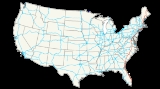
Interstate 95
Encyclopedia
Interstate 95 is the main highway
on the East Coast of the United States
, running parallel to the Atlantic Ocean
from Maine
to Florida
and serving some of the most populated urban areas in the country, including Boston
, Providence
, New Haven
, New York City
, Newark
, Philadelphia, Baltimore
, Washington, D.C.
, Richmond
, Savannah
, Jacksonville and Miami. It is the longest north–south route of the Interstate Highway System
, and supersedes older U.S. Highways, mainly U.S. Route 1
. The oldest sections of I-95, including several toll road
s, predate the Interstate System; the route has yet to be completed in the Pennsylvania
-New Jersey
area. Construction of the missing connection is scheduled to be completed by the 2010s (tentatively 2018).
I-95's two pieces total 1925 mi (3,098 km). The southern terminus of I-95 is at U.S. Route 1 in southern Miami, Florida. The highway heads north along the Atlantic through Jacksonville, Florida
to Savannah, Georgia
, and then takes a slightly more inland route through South Carolina
and North Carolina
to Richmond, Virginia
. From Richmond past Washington D.C. to Baltimore, Maryland, I-95 follows the fall line
, where the Atlantic Coastal Plain
meets the Appalachian Piedmont. The highway continues northeast through Wilmington, Delaware
and Philadelphia, after which traffic must use other roads to continue towards Newark, New Jersey
until the completion of the Pennsylvania Turnpike/Interstate 95 Interchange Project
(planned for 2017). I-95 crosses the George Washington Bridge
into New York City, and then passes through New Haven, Connecticut
and Providence, Rhode Island
, around Boston, Massachusetts, and through Portsmouth, New Hampshire
and Portland, Maine
on its way to U.S. Route 2
and the Houlton/Woodstock Border Crossing
to the short New Brunswick Route 95
, which connects to the Trans-Canada Highway
.
It is the longest north–south Interstate Highway (five east–west routes are longer: Interstate 10
(2460 mi (3,959 km)), Interstate 40
(2555 mi (4,112 km)), Interstate 70
(2153 mi (3,465 km)), Interstate 80
(2899 mi (4,665 km)), and Interstate 90
(3099 mi (4,987 km))), and it passes through fifteen states, more than any other Interstate; the Interstate that passes through the second-most number of states is Interstate 90
, at thirteen. According to the U.S. Census Bureau, only five counties along the route — two in South Carolina, one in southern Virginia, and two in northern Maine — are completely rural
. According to the I-95 Corridor Coalition, the region served by I-95 is "over three times more densely populated than the U.S. average and as densely settled as much of Western Europe".
As of 2007, I-95 is the only non-cancelled long-distance Interstate in the original plans that has not been completed. A discontinuity
exists between two separate sections in New Jersey
and Pennsylvania
due in part to the freeway revolts
of the 1960s and 1970s; thus it is not possible to directly travel the entire length of I-95 without interruption, since the two sections are about 10 miles (16.1 km) apart from each other (though this gap is currently being addressed
).
|FL
|382.17
|615.04
|-
|GA
|112.03
|180.29
|-
|SC
|198.76
|319.87
|-
|NC
|181.71
|292.43
|-
|VA
|178.73
|287.64
|-
|DC
|0.07
|0.12
|-
|MD
|109.05
|175.50
|-
|DE
|23.43
|37.71
|-
|PA
|51.08
|82.21
|-
|NJ
|77.96 (main route)
8.77 (Trenton area)
11.03 (west spur)
97.76 (total)
|125.46
14.11
17.75
157.33
|-
|NY
|23.50
|37.82
|-
|CT
|111.57
|179.55
|-
|RI
|43.3
|69.7
|-
|MA
|91.95
|147.98
|-
|NH
|16.20
|26.08
|-
|ME
|303.2
|488.0
|}
just south of downtown Miami, Florida
, and follows a path north along the Atlantic
coast of Florida, passing near such locations as Florida's Space Coast
, Port Orange and Saint Augustine, Florida before continuing north through Jacksonville
and entering Georgia
. Interstate 95 in Georgia travels through the marshlands of eastern Georgia, closely following the coast to Savannah
, where it intersects Interstate 16, then crosses into South Carolina
. In South Carolina, I-95 travels further inland than its paths to the south, and passes the South of the Border
attraction immediately before crossing into North Carolina
.
The Florida section of I-95 had the most fatalities of all US Turnpikes in 2010.
(Interstate 73
)/U.S. Route 29
, Interstate 77
, and Interstate 26
). I-95 informally serves as separation between the piedmont
and coastal plain
regions of North Carolina. In Virginia
, Interstate 95 roughly follows the same line between the regions, and passes by its state capital, Richmond
, before entering into Northern Virginia
and then crossing via the Woodrow Wilson Bridge
into Maryland
.
, where a small, approximately 0.07 mile (0.1126538 km) portion of the highway passes through the southernmost corner of the District of Columbia. In Maryland, I-95 follows the Capital Beltway
around Washington, D.C. Once leaving the Beltway north of the city, I-95 travels diagonally through the middle of the state, through Baltimore (see Interstate 95 in Baltimore). After this, I-95 goes through northeastern Maryland, crossing over the Millard E. Tydings Memorial Bridge
over the Susquehanna River
in Havre de Grace
along the way. On the other side of the bridge is a tollbooth for northbound traffic only. The highway then goes east to the Delaware border and then toward the city of Wilmington
.
I-95 is the most heavily traveled route in Delaware, linking Washington and south with Philadelphia
and north. After the road enters Delaware from Maryland, a Delaware Turnpike
toll barrier is placed about 0.5 mile (0.80467 km) from the Maryland border. I-95 continues for 23 miles (37 km) to Pennsylvania.
Interstate 95 enters Pennsylvania
along the Delaware River
near Marcus Hook
, traveling along its western bank through the city of Philadelphia, and heading north where it currently enters
New Jersey
near Trenton
in Ewing Township
via the toll-free Scudder Falls Bridge
.
. I-95 ends north of Trenton, NJ, but begins on the New Jersey Turnpike
south of Trenton.
Traffic is directed to continue south in Lawrence Township
where I-95 becomes Interstate 295
south at I-95 milepost 8.7/I-295 milepost 68 near the U.S. 1
exit. Traffic is led down the 295 expressway, and directed to get off at Exit 60A for Interstate 195
east in Hamilton Township
. Traffic is instructed to continue on the 195 expressway east upon reaching Exit 6 for the New Jersey Turnpike
(Turnpike Exit 7A, and the continuation of Interstate 95) in Robbinsville Township.
I-95 then follows the New Jersey Turnpike north through Newark
and into New York
on the George Washington Bridge
. I-95 travels across Manhattan
, The Bronx
, and southern Westchester County in New York
before reaching Connecticut
.
in Connecticut, and follows along the southern part of the state within miles of the coast in a more east–west direction. It then curves back northward, passing into Rhode Island, and traveling through its capital of Providence
. Interstate 95 then enters Massachusetts
, heading not into but around Boston via Route 128 before turning north and passing briefly into and through New Hampshire
, and then into Maine
, following the Maine Turnpike to the Canadian
border
, intersecting the east end of US 2, and entering the province of New Brunswick
as Route 95.
 Portions of the highway have or used to have tolls. Many parts of I-95 were made up of various toll roads that had already been constructed or planned, particularly in the northeast. Many of these routes still exist today, but some have removed their tolls. Every current toll facility is compatible with the E-ZPass
electronic payment system.
 Originally, I-95 ran concurrently on Florida's Turnpike
for 41 miles (66 km) from Palm Beach Gardens
north to Ft. Pierce on the Treasure Coast
. Over time, the I-95 adopted a separate route, including parallel from the Turnpike between Palm Beach Gardens and Stuart, with the turnpike being removed from the I-95 alignment in 1973, and I-95 being completed in 1987.
The Fuller Warren Bridge spans the St. Johns River
in Jacksonville, Florida
. The old bridge was a drawbridge that was tolled until the 1980s. The current bridge was completed in 2002.
was a toll road in central Virginia
. The Turnpike was established in 1955, and opened in July 1958. It extended from the northern limits of Richmond
to just south of Petersburg
on what is now Interstate 85
. In August 1958, most of the route was designated Interstate 95. Tolls were removed in 1992.
The John F. Kennedy Memorial Highway is north of Baltimore. This highway was opened in 1963, and it and the Delaware Turnpike were both dedicated by President John F. Kennedy
. The highway extended from the northern Baltimore city limits to the Delaware
state line. After his assassination
, the highway and the Delaware Turnpike were named the John F. Kennedy Memorial Highway. This highway had a toll in both directions until 1991, when the southbound tolls were canceled. This highway currently has a toll only northbound.
The Delaware Turnpike
, which was opened in 1963, extends I-95 from the Maryland
state line to the south side of Wilmington
at the I-295 interchange. There is a toll for both directions between Delaware Route 896 (exit 1) and the Maryland state line. It is the most expensive toll road in the United States, based on cost-per-mile average; $4.00 in each direction; 35.7 cents per mile.
, along the Delaware River
through Philadelphia, and further north. It continues north past the future site of the Pennsylvania Turnpike/Interstate 95 Interchange Project
, where it currently passes over the Pennsylvania Turnpike
(Interstate 276); the two highways were not built to connect with each other. North of I-276, I-95 interchanges with U.S. Route 1 Business/Pennsylvania Route 413
and U.S. Route 1
. The route heads into Lower Makefield Township
, where it has interchanges with Pennsylvania Route 332
and Taylorsville Road (which provides access to Pennsylvania Route 32
) before crossing the Delaware River
into New Jersey
on the Scudder Falls Bridge
.
opened in 1952, and currently I-95 is signed from Exit 6 (the Pennsylvania Turnpike
Connector) outside Philadelphia north to the New York state line. By 2017, I-95 should follow said connector into Pennsylvania.
George Washington Bridge
carries I-95, US highways 1 and 9, and US 46 across the Hudson River
between New Jersey and Upper Manhattan
. The upper deck of this two-level, fourteen-lane bridge was opened in 1931, and the lower deck was opened in 1962. Northbound traffic (which actually travels slightly southward over this bridge) must pay a toll on the New Jersey end before crossing this bridge into New York.
New England Thruway
in New York extended from the Pelham Parkway interchange in the Bronx, just north of I-695
to the Connecticut
state line. Construction of the NET began in 1951, but the highway was not completed until 1961. In 1956, this Thruway was designated as part of I-95. Tolls were originally levied in both directions, but these were removed from the southbound direction in the late 1980s during a reconstruction of the NET. Currently, tolls are levied on northbound traffic only.
was completed in 1958 and designated as part of I-95. I-95 follows the turnpike through Connecticut from the New York state line to its intersection with I-395
in Waterford
, then continues eastward to the Rhode Island state line. Tolls were removed from the turnpike in 1985 after a notorious fatal car accident at a toll plaza in 1983. In January 2007, the Connecticut Department of Transportation
announced a $4-million study into the feasibility of reinstating tolls on the Connecticut Turnpike.
The New Hampshire Turnpike
is designated as I-95 in New Hampshire
. All of I-95, except approximately the northernmost one mile (1.6 km), in New Hampshire is designated the Blue Star Turnpike, part of the New Hampshire Turnpike System. The Turnpike System diverges from I-95 in Portsmouth
at the interchange with U.S. Route 4
. Tolls are collected once at a mainline plaza in Hampton
.
The Maine Turnpike
was built in two sections, completed in 1947 and 1955. Beginning in 2004, the entirety of the Maine Turnpike was designated as Interstate 95. The Turnpike extends from the New Hampshire
line north 102 miles (164.2 km) to just south of Augusta
. The Maine Turnpike uses entrance tolls at exits south of and including Gray
, and uses barrier toll plazas north of Gray. This allows travel on the southern section without having main line tolls causing major backups and the northern section saves money by requiring fewer toll collection employees. The shifting of I-95 onto the Maine Turnpike also changed the sequentially-numbered exits to a mile-based system, making these the only such marked exits in New England on I-95.
, the two routes diverge substantially for large portions of the route northward. After paralleling U.S. 1
from 95's southern terminus to Jacksonville, FL
, the federal route bears west and I-95 picks up U.S. 17
through Georgia and into southern South Carolina, even multiplexing with it at times. In Walterboro, SC
, U.S. 17
heads east towards Charleston, SC
and U.S. 15
begins paralleling the interstate. This continues for a short distance to Summerton, SC
, where I-95 begins its long close parallel with U.S. 301
. The two never stray more than a few miles from each other all the way to Petersburg, VA
, where U.S. 1
rejoins the parallel of I-95. With the exception of I-95's brief hiatus on the DC
beltway, this remains the case all the way to Baltimore
. Here, though still somewhat paralleled by US-1, I-95 is more closely followed by U.S. 40
, which stays with the interstate to Wilmington, DE
. In Wilmington, U.S. 40
heads east to Atlantic City, NJ
and U.S. 13
begins to follow I-95. This continues to the discontinuity near Trenton, NJ
. Assuming I-95's route to take the soon-to-be-completed connection
, the interstate is paralleled by U.S. 130
to New Brunswick, NJ
, where US-1 again picks up the route. U.S. 1
repeatedly crosses the interstate all the way to Pawcatuck, where I-95 leaves all US routes and instead follows the RI-3 corridor. U.S. 1
, however, again finds the interstate in Providence, RI
and follows it to Boston
, where I-95 was forced to take the beltway around the city. U.S. 1
in Boston
actually follows some of the right-of-way intended for I-95 before its routing was blocked. North of the City, U.S. 1
and I-95 stick together all the way to Portland, ME
, where I-95 takes a more northerly route paralleled by ME 100 to Newport, ME. Here it picks up U.S. 2
, which it keeps all the way to its northern terminus just past Houlton, ME
. Less than three miles from the Canadian border, I-95 intersects U.S. 1
for the last time; the federal route is headed due north for Fort Kent, ME
.
Between Richmond, Virginia
and New Jersey
are a few large projects that are helping to ease traffic along the corridor. The reconstruction of the Springfield Interchange
in Northern Virginia
, just outside Washington, DC, helped to ease traffic at the intersection of Interstate 95, Interstate 495
, and Interstate 395, and surrounding interchanges. The Springfield Interchange is one of the busiest highway junctions on the East Coast
, serving between 400,000 and 500,000 vehicles per day. With the exception of HOT lanes on the Capital Beltway (I-495/95), this project was completed in July 2007.
A few miles to the east is another major project: the Woodrow Wilson Bridge
replacement. The bridge carries Interstates 95 and 495 over the Potomac River
. The former Woodrow Wilson Bridge, which has since been demolished, was a six-lane bridge that was severely over-capacity. The new bridge is actually two bridges comprising a total of twelve lanes; five in each direction, with an additional lane in each direction for future use (rapid-bus or train). This project is nearly complete. The ten lanes opened on the 13th of December 2008 greatly reducing the traffic delays on the beltway. The lanes are divided into 2 thru-lanes and 3 local lanes in each direction. About 30 miles north of the Wilson Bridge (and about 20 miles south of Baltimore
) near the City of Laurel
, a large new interchange is under construction as of 2008 and scheduled for completion in late 2011, which will connect I-95 to Maryland Route 200, the long-planned InterCounty Connector toll road.
Farther north in Pennsylvania
, a project is underway at the intersection of I-95 and I-276. The Pennsylvania Turnpike/Interstate 95 Interchange Project
will construct an interchange between Interstate 95, Interstate 276, and once completed, Interstate 195
, as I-95 will no longer go through Trenton, New Jersey
(actually the townships of Hopewell, Lawrence and Ewing). This project will result in another toll being added to the route, that of the Delaware River-Turnpike Toll Bridge
over the Delaware River
. The toll, much like the other crossings of the river, will be for traffic leaving New Jersey only (I-95 southbound). More critically, completion of this project will close the remaining gap in the route.
In 2006, the Virginia General Assembly passed SJ184, a resolution calling for an interstate compact to build a toll highway between Dover, Delaware
and Charleston, South Carolina
as an alternative to I-95 that would allow long-distance traffic to avoid the DC Metropolitan area.
Federal legislation has identified I-95 through Connecticut as High Priority Corridor 65. A long-term multibillion dollar program to upgrade the entire length of I-95 through Connecticut has been underway since the mid-1990s and is expected to continue through at least 2020. Several miles of the Connecticut Turnpike through Bridgeport
were recently widened and brought up to Interstate standards. Work has shifted to reconstructing and widening 12 miles (19.3 km) of I-95 through New Haven
, which includes replacing the Pearl Harbor Memorial Bridge
. Environmental studies for reconstructing and widening 60 miles (95 km) of I-95 from New Haven to the Rhode Island state line are also progressing.
There are plans to expand the 1054 miles (1,696.2 km) I-95 corridor from Petersburg, Virginia
to Florida
through a U.S. multi-state agreement to study how to improve the corridor through widening and reconstruction, with the goal of reducing congestion and improving overall safety for years to come.
Georgia and Florida continue to complete widening projects. Most of Interstate 95 through Georgia and south to Jacksonville, Florida
has been upgraded to six lanes. The section from Jacksonville to the Interstate 4
junction in Daytona Beach
was expanded to six lanes in 2005. As of 2009, widening projects continue in Brevard County
from the SR 528 junction in Cocoa
to Palm Bay
, as well as in northern Palm Beach County
.
Highway
A highway is any public road. In American English, the term is common and almost always designates major roads. In British English, the term designates any road open to the public. Any interconnected set of highways can be variously referred to as a "highway system", a "highway network", or a...
on the East Coast of the United States
East Coast of the United States
The East Coast of the United States, also known as the Eastern Seaboard, refers to the easternmost coastal states in the United States, which touch the Atlantic Ocean and stretch up to Canada. The term includes the U.S...
, running parallel to the Atlantic Ocean
Atlantic Ocean
The Atlantic Ocean is the second-largest of the world's oceanic divisions. With a total area of about , it covers approximately 20% of the Earth's surface and about 26% of its water surface area...
from Maine
Maine
Maine is a state in the New England region of the northeastern United States, bordered by the Atlantic Ocean to the east and south, New Hampshire to the west, and the Canadian provinces of Quebec to the northwest and New Brunswick to the northeast. Maine is both the northernmost and easternmost...
to Florida
Florida
Florida is a state in the southeastern United States, located on the nation's Atlantic and Gulf coasts. It is bordered to the west by the Gulf of Mexico, to the north by Alabama and Georgia and to the east by the Atlantic Ocean. With a population of 18,801,310 as measured by the 2010 census, it...
and serving some of the most populated urban areas in the country, including Boston
Boston
Boston is the capital of and largest city in Massachusetts, and is one of the oldest cities in the United States. The largest city in New England, Boston is regarded as the unofficial "Capital of New England" for its economic and cultural impact on the entire New England region. The city proper had...
, Providence
Providence, Rhode Island
Providence is the capital and most populous city of Rhode Island and was one of the first cities established in the United States. Located in Providence County, it is the third largest city in the New England region...
, New Haven
New Haven, Connecticut
New Haven is the second-largest city in Connecticut and the sixth-largest in New England. According to the 2010 Census, New Haven's population increased by 5.0% between 2000 and 2010, a rate higher than that of the State of Connecticut, and higher than that of the state's five largest cities, and...
, New York City
New York City
New York is the most populous city in the United States and the center of the New York Metropolitan Area, one of the most populous metropolitan areas in the world. New York exerts a significant impact upon global commerce, finance, media, art, fashion, research, technology, education, and...
, Newark
Newark, New Jersey
Newark is the largest city in the American state of New Jersey, and the seat of Essex County. As of the 2010 United States Census, Newark had a population of 277,140, maintaining its status as the largest municipality in New Jersey. It is the 68th largest city in the U.S...
, Philadelphia, Baltimore
Baltimore
Baltimore is the largest independent city in the United States and the largest city and cultural center of the US state of Maryland. The city is located in central Maryland along the tidal portion of the Patapsco River, an arm of the Chesapeake Bay. Baltimore is sometimes referred to as Baltimore...
, Washington, D.C.
Washington, D.C.
Washington, D.C., formally the District of Columbia and commonly referred to as Washington, "the District", or simply D.C., is the capital of the United States. On July 16, 1790, the United States Congress approved the creation of a permanent national capital as permitted by the U.S. Constitution....
, Richmond
Richmond, Virginia
Richmond is the capital of the Commonwealth of Virginia, in the United States. It is an independent city and not part of any county. Richmond is the center of the Richmond Metropolitan Statistical Area and the Greater Richmond area...
, Savannah
Savannah, Georgia
Savannah is the largest city and the county seat of Chatham County, in the U.S. state of Georgia. Established in 1733, the city of Savannah was the colonial capital of the Province of Georgia and later the first state capital of Georgia. Today Savannah is an industrial center and an important...
, Jacksonville and Miami. It is the longest north–south route of the Interstate Highway System
Interstate Highway System
The Dwight D. Eisenhower National System of Interstate and Defense Highways, , is a network of limited-access roads including freeways, highways, and expressways forming part of the National Highway System of the United States of America...
, and supersedes older U.S. Highways, mainly U.S. Route 1
U.S. Route 1
U.S. Route 1 is a major north–south U.S. Highway that serves the East Coast of the United States. It runs 2,377 miles from Fort Kent, Maine at the Canadian border south to Key West, Florida. U.S. 1 generally parallels Interstate 95, though it is significantly farther west between...
. The oldest sections of I-95, including several toll road
Toll road
A toll road is a privately or publicly built road for which a driver pays a toll for use. Structures for which tolls are charged include toll bridges and toll tunnels. Non-toll roads are financed using other sources of revenue, most typically fuel tax or general tax funds...
s, predate the Interstate System; the route has yet to be completed in the Pennsylvania
Pennsylvania
The Commonwealth of Pennsylvania is a U.S. state that is located in the Northeastern and Mid-Atlantic regions of the United States. The state borders Delaware and Maryland to the south, West Virginia to the southwest, Ohio to the west, New York and Ontario, Canada, to the north, and New Jersey to...
-New Jersey
New Jersey
New Jersey is a state in the Northeastern and Middle Atlantic regions of the United States. , its population was 8,791,894. It is bordered on the north and east by the state of New York, on the southeast and south by the Atlantic Ocean, on the west by Pennsylvania and on the southwest by Delaware...
area. Construction of the missing connection is scheduled to be completed by the 2010s (tentatively 2018).
I-95's two pieces total 1925 mi (3,098 km). The southern terminus of I-95 is at U.S. Route 1 in southern Miami, Florida. The highway heads north along the Atlantic through Jacksonville, Florida
Jacksonville, Florida
Jacksonville is the largest city in the U.S. state of Florida in terms of both population and land area, and the largest city by area in the contiguous United States. It is the county seat of Duval County, with which the city government consolidated in 1968...
to Savannah, Georgia
Savannah, Georgia
Savannah is the largest city and the county seat of Chatham County, in the U.S. state of Georgia. Established in 1733, the city of Savannah was the colonial capital of the Province of Georgia and later the first state capital of Georgia. Today Savannah is an industrial center and an important...
, and then takes a slightly more inland route through South Carolina
South Carolina
South Carolina is a state in the Deep South of the United States that borders Georgia to the south, North Carolina to the north, and the Atlantic Ocean to the east. Originally part of the Province of Carolina, the Province of South Carolina was one of the 13 colonies that declared independence...
and North Carolina
North Carolina
North Carolina is a state located in the southeastern United States. The state borders South Carolina and Georgia to the south, Tennessee to the west and Virginia to the north. North Carolina contains 100 counties. Its capital is Raleigh, and its largest city is Charlotte...
to Richmond, Virginia
Richmond, Virginia
Richmond is the capital of the Commonwealth of Virginia, in the United States. It is an independent city and not part of any county. Richmond is the center of the Richmond Metropolitan Statistical Area and the Greater Richmond area...
. From Richmond past Washington D.C. to Baltimore, Maryland, I-95 follows the fall line
Fall line
A fall line is a geomorphologic unconformity between an upland region of relatively hard crystalline basement rock and a coastal plain of softer sedimentary rock. A fall line is typically prominent when crossed by a river, for there will often be rapids or waterfalls...
, where the Atlantic Coastal Plain
Atlantic Coastal Plain
The Atlantic coastal plain has both low elevation and low relief, but it is also a relatively flat landform extending from the New York Bight southward to a Georgia/Florida section of the Eastern Continental Divide, which demarcates the plain from the ACF River Basin in the Gulf Coastal Plain to...
meets the Appalachian Piedmont. The highway continues northeast through Wilmington, Delaware
Wilmington, Delaware
Wilmington is the largest city in the state of Delaware, United States, and is located at the confluence of the Christina River and Brandywine Creek, near where the Christina flows into the Delaware River. It is the county seat of New Castle County and one of the major cities in the Delaware Valley...
and Philadelphia, after which traffic must use other roads to continue towards Newark, New Jersey
Newark, New Jersey
Newark is the largest city in the American state of New Jersey, and the seat of Essex County. As of the 2010 United States Census, Newark had a population of 277,140, maintaining its status as the largest municipality in New Jersey. It is the 68th largest city in the U.S...
until the completion of the Pennsylvania Turnpike/Interstate 95 Interchange Project
Pennsylvania Turnpike/Interstate 95 Interchange Project
The Pennsylvania Turnpike/Interstate 95 Interchange Project is a project to build an interchange where Interstate 95 crosses the Pennsylvania Turnpike in Bristol Township, Pennsylvania. This will fill the gap that exists on I-95 through New Jersey due to the cancellation of the Somerset Freeway....
(planned for 2017). I-95 crosses the George Washington Bridge
George Washington Bridge
The George Washington Bridge is a suspension bridge spanning the Hudson River, connecting the Washington Heights neighborhood in the borough of Manhattan in New York City to Fort Lee, Bergen County, New Jersey. Interstate 95 and U.S. Route 1/9 cross the river via the bridge. U.S...
into New York City, and then passes through New Haven, Connecticut
New Haven, Connecticut
New Haven is the second-largest city in Connecticut and the sixth-largest in New England. According to the 2010 Census, New Haven's population increased by 5.0% between 2000 and 2010, a rate higher than that of the State of Connecticut, and higher than that of the state's five largest cities, and...
and Providence, Rhode Island
Providence, Rhode Island
Providence is the capital and most populous city of Rhode Island and was one of the first cities established in the United States. Located in Providence County, it is the third largest city in the New England region...
, around Boston, Massachusetts, and through Portsmouth, New Hampshire
Portsmouth, New Hampshire
Portsmouth is a city in Rockingham County, New Hampshire in the United States. It is the largest city but only the fourth-largest community in the county, with a population of 21,233 at the 2010 census...
and Portland, Maine
Portland, Maine
Portland is the largest city in Maine and is the county seat of Cumberland County. The 2010 city population was 66,194, growing 3 percent since the census of 2000...
on its way to U.S. Route 2
U.S. Route 2
U.S. Route 2 is an east–west U.S. Highway spanning across the northern continental United States. US 2 consists of two segments connected by various roadways in southern Canada...
and the Houlton/Woodstock Border Crossing
Houlton/Woodstock Border Crossing
The Houlton–Woodstock Border Crossing, also known as Woodstock Road Border Crossing is a border crossing on the Canada-United States border, east of Houlton, Maine and west of Woodstock, New Brunswick....
to the short New Brunswick Route 95
New Brunswick Route 95
Route 95 is a long provincial highway in New Brunswick, which serves a connector route between Interstate 95 and U.S. Route 2 at the Houlton–Woodstock Border Crossing near Houlton, Maine, United States to Route 2, which is part of the Trans-Canada Highway, in Woodstock, New Brunswick, Canada...
, which connects to the Trans-Canada Highway
Trans-Canada Highway
The Trans-Canada Highway is a federal-provincial highway system that joins the ten provinces of Canada. It is, along with the Trans-Siberian Highway and Australia's Highway 1, one of the world's longest national highways, with the main route spanning 8,030 km...
.
It is the longest north–south Interstate Highway (five east–west routes are longer: Interstate 10
Interstate 10
Interstate 10 is the fourth-longest Interstate Highway in the United States, after I-90, I-80, and I-40. It is the southernmost east–west, coast-to-coast Interstate Highway, although I-4 and I-8 are further south. It stretches from the Pacific Ocean at State Route 1 in Santa Monica,...
(2460 mi (3,959 km)), Interstate 40
Interstate 40
Interstate 40 is the third-longest major east–west Interstate Highway in the United States, after I-90 and I-80. Its western end is at Interstate 15 in Barstow, California; its eastern end is at a concurrency of U.S. Route 117 and North Carolina Highway 132 in Wilmington, North Carolina...
(2555 mi (4,112 km)), Interstate 70
Interstate 70
Interstate 70 is an Interstate Highway in the United States that runs from Interstate 15 near Cove Fort, Utah, to a Park and Ride near Baltimore, Maryland. It was the first Interstate Highway project in the United States. I-70 approximately traces the path of U.S. Route 40 east of the Rocky...
(2153 mi (3,465 km)), Interstate 80
Interstate 80
Interstate 80 is the second-longest Interstate Highway in the United States, following Interstate 90. It is a transcontinental artery running from downtown San Francisco, California to Teaneck, New Jersey in the New York City Metropolitan Area...
(2899 mi (4,665 km)), and Interstate 90
Interstate 90
Interstate 90 is the longest Interstate Highway in the United States at . It is the northernmost coast-to-coast interstate, and parallels US 20 for the most part. Its western terminus is in Seattle, at Edgar Martinez Drive S. near Safeco Field and CenturyLink Field, and its eastern terminus is in...
(3099 mi (4,987 km))), and it passes through fifteen states, more than any other Interstate; the Interstate that passes through the second-most number of states is Interstate 90
Interstate 90
Interstate 90 is the longest Interstate Highway in the United States at . It is the northernmost coast-to-coast interstate, and parallels US 20 for the most part. Its western terminus is in Seattle, at Edgar Martinez Drive S. near Safeco Field and CenturyLink Field, and its eastern terminus is in...
, at thirteen. According to the U.S. Census Bureau, only five counties along the route — two in South Carolina, one in southern Virginia, and two in northern Maine — are completely rural
Rural
Rural areas or the country or countryside are areas that are not urbanized, though when large areas are described, country towns and smaller cities will be included. They have a low population density, and typically much of the land is devoted to agriculture...
. According to the I-95 Corridor Coalition, the region served by I-95 is "over three times more densely populated than the U.S. average and as densely settled as much of Western Europe".
As of 2007, I-95 is the only non-cancelled long-distance Interstate in the original plans that has not been completed. A discontinuity
Interstate 95 in New Jersey
Interstate 95 is a major Interstate Highway that traverses the full extent of the East Coast of the United States, from Florida to Maine...
exists between two separate sections in New Jersey
New Jersey
New Jersey is a state in the Northeastern and Middle Atlantic regions of the United States. , its population was 8,791,894. It is bordered on the north and east by the state of New York, on the southeast and south by the Atlantic Ocean, on the west by Pennsylvania and on the southwest by Delaware...
and Pennsylvania
Pennsylvania
The Commonwealth of Pennsylvania is a U.S. state that is located in the Northeastern and Mid-Atlantic regions of the United States. The state borders Delaware and Maryland to the south, West Virginia to the southwest, Ohio to the west, New York and Ontario, Canada, to the north, and New Jersey to...
due in part to the freeway revolts
Freeway and expressway revolts
Many freeway revolts took place in developed countries during the 1960s and 1970s, in response to plans for the construction of new freeways, a significant number of which were abandoned or significantly scaled back due to widespread public opposition; especially of those whose neighborhoods would...
of the 1960s and 1970s; thus it is not possible to directly travel the entire length of I-95 without interruption, since the two sections are about 10 miles (16.1 km) apart from each other (though this gap is currently being addressed
Pennsylvania Turnpike/Interstate 95 Interchange Project
The Pennsylvania Turnpike/Interstate 95 Interchange Project is a project to build an interchange where Interstate 95 crosses the Pennsylvania Turnpike in Bristol Township, Pennsylvania. This will fill the gap that exists on I-95 through New Jersey due to the cancellation of the Somerset Freeway....
).
Route description
|-|FL
Interstate 95 in Florida
Interstate 95 is the main Interstate Highway on the east coast of the United States; it serves the Atlantic coast of Florida. It begins at a partial interchange with U.S. Highway 1 just south of downtown Miami, and heads north past Daytona Beach and Jacksonville to the Georgia state line at the St...
|382.17
|615.04
|-
|GA
Interstate 95 in Georgia
Interstate 95, the main Interstate Highway on the east coast of the United States, serves the Atlantic coast of Georgia. It begins at the St. Marys River at the Florida state line north of Jacksonville and heads north past the border of South Carolina at the Savannah River...
|112.03
|180.29
|-
|SC
Interstate 95 in South Carolina
Interstate 95 is a major Interstate Highway, running along the East Coast of the United States from Florida to Maine. In South Carolina, I-95 runs approximately parallel to the Atlantic Ocean shore although about inland, from Hardeeville in the south to Dillon in the northeast.-Route...
|198.76
|319.87
|-
|NC
Interstate 95 in North Carolina
Interstate 95 is a major Interstate Highway, running along the East Coast of the United States from Florida to Maine. In North Carolina, I-95 runs diagonally across the eastern third of the state, from Rowland in the southwest to Roanoke Rapids in the northeast of the Inner Banks.-Route...
|181.71
|292.43
|-
|VA
Interstate 95 in Virginia
In the Commonwealth of Virginia, Interstate 95 runs through the state. It runs concurrently for with Interstate 64 in Richmond, and meets the northern terminus of Interstate 85 in Petersburg. Though Interstate 95 was originally planned to go straight through Washington, D.C., it was instead...
|178.73
|287.64
|-
|DC
|0.07
|0.12
|-
|MD
Interstate 95 in Maryland
Interstate 95 in Maryland is a major highway that runs diagonally from northeast to southwest, from Maryland's border with Delaware, to the Woodrow Wilson Bridge, briefly entering the District of Columbia before reaching Virginia...
|109.05
|175.50
|-
|DE
Interstate 95 in Delaware
In Delaware, Interstate 95 runs diagonally from the border with Maryland northeast to the border with Pennsylvania. Between the Maryland state line and exit 5, I-95 is also designated as the Delaware Turnpike and the John F. Kennedy Memorial Highway. Along with its auxiliaries, I-95 is the only...
|23.43
|37.71
|-
|PA
Interstate 95 in Pennsylvania
Interstate 95 is an Interstate highway running from Miami, Florida north to Houlton, Maine. In the U.S. state of Pennsylvania, the route is known by many as the Delaware Expressway, but is officially named The Vietnam Veterans Memorial Highway. and locally known as "95"...
|51.08
|82.21
|-
|NJ
Interstate 95 in New Jersey
Interstate 95 is a major Interstate Highway that traverses the full extent of the East Coast of the United States, from Florida to Maine...
|77.96 (main route)
8.77 (Trenton area)
11.03 (west spur)
97.76 (total)
|125.46
14.11
17.75
157.33
|-
|NY
Interstate 95 in New York
Interstate 95 is a part of the Interstate Highway System that runs from Miami, Florida, to the Canada – United States border near Houlton, Maine. In the U.S. state of New York, I-95 extends from the George Washington Bridge in New York City to the Connecticut state line at Port Chester...
|23.50
|37.82
|-
|CT
Interstate 95 in Connecticut
Interstate 95, the main north–south Interstate Highway on the East Coast of the United States, runs in a general east–west compass direction for 111.57 miles in Connecticut from the Rhode Island state line to the New York State line. I-95 Southbound from East Lyme to the New York State...
|111.57
|179.55
|-
|RI
Interstate 95 in Rhode Island
Interstate 95, the main north–south Interstate Highway on the east coast of the United States, runs generally southwest-northeast through the U.S. state of Rhode Island. It runs from the border with Connecticut near Westerly through Warwick and Providence and to the Massachusetts state line...
|43.3
|69.7
|-
|MA
Interstate 95 in Massachusetts
Interstate 95 is the main highway on the East Coast of the United States, paralleling the Atlantic Ocean from Florida to Maine. The Massachusetts portion of the highway enters from the state of Rhode Island in Attleboro and travels in a northeasterly direction to the junction with Route 128 in...
|91.95
|147.98
|-
|NH
Interstate 95 in New Hampshire
Interstate 95, the main Interstate Highway on the east coast of the United States, cuts through the Seacoast Region of New Hampshire. The majority of it, from the Massachusetts border to the Portsmouth Circle in Portsmouth, is the 14.29-mile Blue Star Turnpike or New Hampshire Turnpike, a toll...
|16.20
|26.08
|-
|ME
Interstate 95 in Maine
In the U.S. state of Maine, Interstate 95 is a long highway running from the New Hampshire border near Kittery, to the Canadian border near Houlton. It is the only two-digit Interstate Highway in Maine...
|303.2
|488.0
|}
Florida to South Carolina
Interstate 95 begins at U.S. Route 1U.S. Route 1
U.S. Route 1 is a major north–south U.S. Highway that serves the East Coast of the United States. It runs 2,377 miles from Fort Kent, Maine at the Canadian border south to Key West, Florida. U.S. 1 generally parallels Interstate 95, though it is significantly farther west between...
just south of downtown Miami, Florida
Miami, Florida
Miami is a city located on the Atlantic coast in southeastern Florida and the county seat of Miami-Dade County, the most populous county in Florida and the eighth-most populous county in the United States with a population of 2,500,625...
, and follows a path north along the Atlantic
Atlantic Ocean
The Atlantic Ocean is the second-largest of the world's oceanic divisions. With a total area of about , it covers approximately 20% of the Earth's surface and about 26% of its water surface area...
coast of Florida, passing near such locations as Florida's Space Coast
Space Coast
The Space Coast is a region in the U.S. state of Florida around Kennedy Space Center , where NASA launched space shuttles until the last one on July 8th, 2011 at 11:29am; and Cape Canaveral Air Force Station, site of unmanned civilian and military space launches...
, Port Orange and Saint Augustine, Florida before continuing north through Jacksonville
Jacksonville, Florida
Jacksonville is the largest city in the U.S. state of Florida in terms of both population and land area, and the largest city by area in the contiguous United States. It is the county seat of Duval County, with which the city government consolidated in 1968...
and entering Georgia
Georgia (U.S. state)
Georgia is a state located in the southeastern United States. It was established in 1732, the last of the original Thirteen Colonies. The state is named after King George II of Great Britain. Georgia was the fourth state to ratify the United States Constitution, on January 2, 1788...
. Interstate 95 in Georgia travels through the marshlands of eastern Georgia, closely following the coast to Savannah
Savannah, Georgia
Savannah is the largest city and the county seat of Chatham County, in the U.S. state of Georgia. Established in 1733, the city of Savannah was the colonial capital of the Province of Georgia and later the first state capital of Georgia. Today Savannah is an industrial center and an important...
, where it intersects Interstate 16, then crosses into South Carolina
South Carolina
South Carolina is a state in the Deep South of the United States that borders Georgia to the south, North Carolina to the north, and the Atlantic Ocean to the east. Originally part of the Province of Carolina, the Province of South Carolina was one of the 13 colonies that declared independence...
. In South Carolina, I-95 travels further inland than its paths to the south, and passes the South of the Border
South of the Border (attraction)
South of the Border is a rest stop and roadside attraction on Interstate 95 and US Highway 301/501 between Dillon, South Carolina and Rowland, North Carolina. It is named "south of the border" being south of the U.S. state of North Carolina...
attraction immediately before crossing into North Carolina
North Carolina
North Carolina is a state located in the southeastern United States. The state borders South Carolina and Georgia to the south, Tennessee to the west and Virginia to the north. North Carolina contains 100 counties. Its capital is Raleigh, and its largest city is Charlotte...
.
The Florida section of I-95 had the most fatalities of all US Turnpikes in 2010.
North Carolina and Virginia
Interstate 95 in North Carolina is one of four major north–south corridors through the state (the others being U.S. Route 220U.S. Route 220
U.S. Route 220 is a long U.S. Route in the eastern United States.US 220 is a spur route of U.S. Route 20 but at present, the two routes do not intersect nor do they connect via other spurs of US 20. The former U. S. Route 120, which was signed in Pennsylvania between 1926 and 1967, intersected...
(Interstate 73
Interstate 73
Interstate 73 is a main route of the Interstate Highway System, currently located entirely within the U.S. state of North Carolina. It is part of a longer planned corridor, defined by various Federal laws to run from Myrtle Beach, South Carolina, to Grayling, Michigan, but only the part south of...
)/U.S. Route 29
U.S. Route 29
U.S. Route 29 is a north–south United States highway that runs for from the western suburbs of Baltimore, Maryland, to Pensacola, Florida. This highway's northern terminus is at Maryland Route 99 in Ellicott City, Maryland...
, Interstate 77
Interstate 77 in North Carolina
In the U.S. state of North Carolina, Interstate 77 is a Interstate Highway, which serves the city of Charlotte and the Western Piedmont.-Route description:...
, and Interstate 26
Interstate 26
Interstate 26 is a nominally east–west main route of the Interstate Highway System in the Southeastern United States. I-26 runs from the junction of U.S. Route 11W and U.S. Route 23 in Kingsport, Tennessee, generally southeastward to U.S. Route 17 in Charleston, South Carolina...
). I-95 informally serves as separation between the piedmont
Piedmont (United States)
The Piedmont is a plateau region located in the eastern United States between the Atlantic Coastal Plain and the main Appalachian Mountains, stretching from New Jersey in the north to central Alabama in the south. The Piedmont province is a physiographic province of the larger Appalachian division...
and coastal plain
Atlantic Coastal Plain
The Atlantic coastal plain has both low elevation and low relief, but it is also a relatively flat landform extending from the New York Bight southward to a Georgia/Florida section of the Eastern Continental Divide, which demarcates the plain from the ACF River Basin in the Gulf Coastal Plain to...
regions of North Carolina. In Virginia
Virginia
The Commonwealth of Virginia , is a U.S. state on the Atlantic Coast of the Southern United States. Virginia is nicknamed the "Old Dominion" and sometimes the "Mother of Presidents" after the eight U.S. presidents born there...
, Interstate 95 roughly follows the same line between the regions, and passes by its state capital, Richmond
Richmond, Virginia
Richmond is the capital of the Commonwealth of Virginia, in the United States. It is an independent city and not part of any county. Richmond is the center of the Richmond Metropolitan Statistical Area and the Greater Richmond area...
, before entering into Northern Virginia
Northern Virginia
Northern Virginia consists of several counties and independent cities in the Commonwealth of Virginia, in a widespread region generally radiating southerly and westward from Washington, D.C...
and then crossing via the Woodrow Wilson Bridge
Woodrow Wilson Bridge
The Woodrow Wilson Memorial Bridge is a bascule bridge that spans the Potomac River between the independent city of Alexandria, Virginia and Oxon Hill in Prince George's County, Maryland, United States. While over the water near the Virginia shore, it crosses the southern tip of the District of...
into Maryland
Maryland
Maryland is a U.S. state located in the Mid Atlantic region of the United States, bordering Virginia, West Virginia, and the District of Columbia to its south and west; Pennsylvania to its north; and Delaware to its east...
.
Maryland, Delaware, and Pennsylvania
Interstate 95 enters Maryland on the Woodrow Wilson BridgeWoodrow Wilson Bridge
The Woodrow Wilson Memorial Bridge is a bascule bridge that spans the Potomac River between the independent city of Alexandria, Virginia and Oxon Hill in Prince George's County, Maryland, United States. While over the water near the Virginia shore, it crosses the southern tip of the District of...
, where a small, approximately 0.07 mile (0.1126538 km) portion of the highway passes through the southernmost corner of the District of Columbia. In Maryland, I-95 follows the Capital Beltway
Interstate 495 (Capital Beltway)
Interstate 495 is a Interstate Highway that surrounds the United States' capital of Washington, D.C., and its inner suburbs in adjacent Maryland and Virginia. I-495 is widely known as the Capital Beltway or simply the Beltway, especially when the context of Washington, D.C., is clear...
around Washington, D.C. Once leaving the Beltway north of the city, I-95 travels diagonally through the middle of the state, through Baltimore (see Interstate 95 in Baltimore). After this, I-95 goes through northeastern Maryland, crossing over the Millard E. Tydings Memorial Bridge
Millard E. Tydings Memorial Bridge
The Millard E. Tydings Memorial Bridge is located on the John F. Kennedy Memorial Highway in Maryland and carries Interstate 95 over the Susquehanna River between Cecil County and Harford County. Its annual traffic is 29 million vehicles....
over the Susquehanna River
Susquehanna River
The Susquehanna River is a river located in the northeastern United States. At long, it is the longest river on the American east coast that drains into the Atlantic Ocean, and with its watershed it is the 16th largest river in the United States, and the longest river in the continental United...
in Havre de Grace
Havre de Grace, Maryland
Havre de Grace is a city in Harford County, Maryland, United States. Located at the mouth of the Susquehanna River and the head of the Chesapeake Bay, Havre de Grace is named after the port city of Le Havre, France, which was first named Le Havre de Grâce, meaning in French "Harbor of Grace." As...
along the way. On the other side of the bridge is a tollbooth for northbound traffic only. The highway then goes east to the Delaware border and then toward the city of Wilmington
Wilmington, Delaware
Wilmington is the largest city in the state of Delaware, United States, and is located at the confluence of the Christina River and Brandywine Creek, near where the Christina flows into the Delaware River. It is the county seat of New Castle County and one of the major cities in the Delaware Valley...
.
I-95 is the most heavily traveled route in Delaware, linking Washington and south with Philadelphia
Philadelphia, Pennsylvania
Philadelphia is the largest city in the Commonwealth of Pennsylvania and the county seat of Philadelphia County, with which it is coterminous. The city is located in the Northeastern United States along the Delaware and Schuylkill rivers. It is the fifth-most-populous city in the United States,...
and north. After the road enters Delaware from Maryland, a Delaware Turnpike
Delaware Turnpike
The Delaware Turnpike, also known as the John F. Kennedy Memorial Highway, is an tolled highway that lies entirely within the state of Delaware. Running in a general southwest to northeast direction, paralleling nearby U.S...
toll barrier is placed about 0.5 mile (0.80467 km) from the Maryland border. I-95 continues for 23 miles (37 km) to Pennsylvania.
Interstate 95 enters Pennsylvania
Pennsylvania
The Commonwealth of Pennsylvania is a U.S. state that is located in the Northeastern and Mid-Atlantic regions of the United States. The state borders Delaware and Maryland to the south, West Virginia to the southwest, Ohio to the west, New York and Ontario, Canada, to the north, and New Jersey to...
along the Delaware River
Delaware River
The Delaware River is a major river on the Atlantic coast of the United States.A Dutch expedition led by Henry Hudson in 1609 first mapped the river. The river was christened the South River in the New Netherland colony that followed, in contrast to the North River, as the Hudson River was then...
near Marcus Hook
Marcus Hook, Pennsylvania
Marcus Hook is a borough in Delaware County, Pennsylvania, United States. The population peaked in the 1920s with 5,324 inhabitants. 2,314 inhabitants were counted at the recent 2000 census. Marcus Hook's current mayor is James Schiliro. The borough calls itself "The Cornerstone of Pennsylvania"....
, traveling along its western bank through the city of Philadelphia, and heading north where it currently enters
Pennsylvania Turnpike/Interstate 95 Interchange Project
The Pennsylvania Turnpike/Interstate 95 Interchange Project is a project to build an interchange where Interstate 95 crosses the Pennsylvania Turnpike in Bristol Township, Pennsylvania. This will fill the gap that exists on I-95 through New Jersey due to the cancellation of the Somerset Freeway....
New Jersey
New Jersey
New Jersey is a state in the Northeastern and Middle Atlantic regions of the United States. , its population was 8,791,894. It is bordered on the north and east by the state of New York, on the southeast and south by the Atlantic Ocean, on the west by Pennsylvania and on the southwest by Delaware...
near Trenton
Trenton, New Jersey
Trenton is the capital of the U.S. state of New Jersey and the county seat of Mercer County. As of the 2010 United States Census, Trenton had a population of 84,913...
in Ewing Township
Ewing Township, New Jersey
-Demographics:As of the 2010 Census, there were 35,790 people, 13,171 households, and 7,980 families residing in the township. There were 13,926 housing units. The racial makeup of the township was 63.1% White, 27.6% African American, 0.3% Native American, 4.3% Asian, 0.0% Pacific Islander, 2.2%...
via the toll-free Scudder Falls Bridge
Scudder Falls Bridge
The Scudder Falls Bridge is a girder bridge that carries Interstate 95 over the Delaware River, connecting Lower Makefield Township in Bucks County, Pennsylvania with Ewing Township in Mercer County, New Jersey. This bridge, which was constructed from 1958 to 1959, is maintained by the Delaware...
.
New Jersey and New York; completion of last gap in the highway
There is currently a gap in I-95 that is in the process of being filled via the Pennsylvania Turnpike/Interstate 95 Interchange ProjectPennsylvania Turnpike/Interstate 95 Interchange Project
The Pennsylvania Turnpike/Interstate 95 Interchange Project is a project to build an interchange where Interstate 95 crosses the Pennsylvania Turnpike in Bristol Township, Pennsylvania. This will fill the gap that exists on I-95 through New Jersey due to the cancellation of the Somerset Freeway....
. I-95 ends north of Trenton, NJ, but begins on the New Jersey Turnpike
New Jersey Turnpike
The New Jersey Turnpike is a toll road in New Jersey, maintained by the New Jersey Turnpike Authority. According to the International Bridge, Tunnel and Turnpike Association, the Turnpike is the nation's sixth-busiest toll road and is among one of the most heavily traveled highways in the United...
south of Trenton.
Traffic is directed to continue south in Lawrence Township
Lawrence Township, Mercer County, New Jersey
Area residents often refer to all of Lawrence Township as Lawrenceville. Lawrenceville is a census-designated place and unincorporated area located within Lawrence Township...
where I-95 becomes Interstate 295
Interstate 295 (Delaware-New Jersey)
Interstate 295 in New Jersey and Delaware is an auxiliary Interstate Highway, designated as a bypass around Philadelphia, Pennsylvania. The route begins at a junction with Interstate 95 south of Wilmington, Delaware, and runs to another junction with I-95 north of Trenton, New Jersey...
south at I-95 milepost 8.7/I-295 milepost 68 near the U.S. 1
U.S. Route 1
U.S. Route 1 is a major north–south U.S. Highway that serves the East Coast of the United States. It runs 2,377 miles from Fort Kent, Maine at the Canadian border south to Key West, Florida. U.S. 1 generally parallels Interstate 95, though it is significantly farther west between...
exit. Traffic is led down the 295 expressway, and directed to get off at Exit 60A for Interstate 195
Interstate 195 (New Jersey)
Interstate 195 is an auxiliary route of the Interstate Highway System located in the U.S. state of New Jersey. Its western end is at I-295 and Route 29 just south of Trenton, New Jersey in Hamilton Township, Mercer County while its eastern end is at the Garden State Parkway, Route 34 and Route...
east in Hamilton Township
Hamilton Township, Mercer County, New Jersey
Hamilton Township is a Township in Mercer County, New Jersey, United States. As of the United States 2010 Census, the township had a total population of 88,464...
. Traffic is instructed to continue on the 195 expressway east upon reaching Exit 6 for the New Jersey Turnpike
New Jersey Turnpike
The New Jersey Turnpike is a toll road in New Jersey, maintained by the New Jersey Turnpike Authority. According to the International Bridge, Tunnel and Turnpike Association, the Turnpike is the nation's sixth-busiest toll road and is among one of the most heavily traveled highways in the United...
(Turnpike Exit 7A, and the continuation of Interstate 95) in Robbinsville Township.
I-95 then follows the New Jersey Turnpike north through Newark
Newark, New Jersey
Newark is the largest city in the American state of New Jersey, and the seat of Essex County. As of the 2010 United States Census, Newark had a population of 277,140, maintaining its status as the largest municipality in New Jersey. It is the 68th largest city in the U.S...
and into New York
New York
New York is a state in the Northeastern region of the United States. It is the nation's third most populous state. New York is bordered by New Jersey and Pennsylvania to the south, and by Connecticut, Massachusetts and Vermont to the east...
on the George Washington Bridge
George Washington Bridge
The George Washington Bridge is a suspension bridge spanning the Hudson River, connecting the Washington Heights neighborhood in the borough of Manhattan in New York City to Fort Lee, Bergen County, New Jersey. Interstate 95 and U.S. Route 1/9 cross the river via the bridge. U.S...
. I-95 travels across Manhattan
Manhattan
Manhattan is the oldest and the most densely populated of the five boroughs of New York City. Located primarily on the island of Manhattan at the mouth of the Hudson River, the boundaries of the borough are identical to those of New York County, an original county of the state of New York...
, The Bronx
The Bronx
The Bronx is the northernmost of the five boroughs of New York City. It is also known as Bronx County, the last of the 62 counties of New York State to be incorporated...
, and southern Westchester County in New York
New York
New York is a state in the Northeastern region of the United States. It is the nation's third most populous state. New York is bordered by New Jersey and Pennsylvania to the south, and by Connecticut, Massachusetts and Vermont to the east...
before reaching Connecticut
Connecticut
Connecticut is a state in the New England region of the northeastern United States. It is bordered by Rhode Island to the east, Massachusetts to the north, and the state of New York to the west and the south .Connecticut is named for the Connecticut River, the major U.S. river that approximately...
.
New England
Interstate 95 enters New EnglandNew England
New England is a region in the northeastern corner of the United States consisting of the six states of Maine, New Hampshire, Vermont, Massachusetts, Rhode Island, and Connecticut...
in Connecticut, and follows along the southern part of the state within miles of the coast in a more east–west direction. It then curves back northward, passing into Rhode Island, and traveling through its capital of Providence
Providence, Rhode Island
Providence is the capital and most populous city of Rhode Island and was one of the first cities established in the United States. Located in Providence County, it is the third largest city in the New England region...
. Interstate 95 then enters Massachusetts
Massachusetts
The Commonwealth of Massachusetts is a state in the New England region of the northeastern United States of America. It is bordered by Rhode Island and Connecticut to the south, New York to the west, and Vermont and New Hampshire to the north; at its east lies the Atlantic Ocean. As of the 2010...
, heading not into but around Boston via Route 128 before turning north and passing briefly into and through New Hampshire
New Hampshire
New Hampshire is a state in the New England region of the northeastern United States of America. The state was named after the southern English county of Hampshire. It is bordered by Massachusetts to the south, Vermont to the west, Maine and the Atlantic Ocean to the east, and the Canadian...
, and then into Maine
Maine
Maine is a state in the New England region of the northeastern United States, bordered by the Atlantic Ocean to the east and south, New Hampshire to the west, and the Canadian provinces of Quebec to the northwest and New Brunswick to the northeast. Maine is both the northernmost and easternmost...
, following the Maine Turnpike to the Canadian
Canada
Canada is a North American country consisting of ten provinces and three territories. Located in the northern part of the continent, it extends from the Atlantic Ocean in the east to the Pacific Ocean in the west, and northward into the Arctic Ocean...
border
Houlton/Woodstock Border Crossing
The Houlton–Woodstock Border Crossing, also known as Woodstock Road Border Crossing is a border crossing on the Canada-United States border, east of Houlton, Maine and west of Woodstock, New Brunswick....
, intersecting the east end of US 2, and entering the province of New Brunswick
New Brunswick
New Brunswick is one of Canada's three Maritime provinces and is the only province in the federation that is constitutionally bilingual . The provincial capital is Fredericton and Saint John is the most populous city. Greater Moncton is the largest Census Metropolitan Area...
as Route 95.
History
E-ZPass
E-ZPass is an electronic toll-collection system used on most tolled roads, bridges, and tunnels in the northeastern US, south to Virginia and West Virginia, and west to Illinois. Currently, there are 25 agencies spread across 14 states that make up the . All member agencies use the same technology,...
electronic payment system.
Florida
Florida's Turnpike
Florida's Turnpike , designated as the Ronald Reagan Turnpike, and originally known as the Sunshine State Parkway is a north–south toll road that runs through 11 counties in the Florida peninsula, from U.S...
for 41 miles (66 km) from Palm Beach Gardens
Palm Beach Gardens, Florida
Palm Beach Gardens is a city in Palm Beach County in the U.S. state of Florida. The city is in the center of a rapidly-developing area north of West Palm Beach in the northern part of the county and the South Florida metropolitan area. , the population was 48,452...
north to Ft. Pierce on the Treasure Coast
Treasure Coast
The Treasure Coast is a region in the U.S. state of Florida, generally considered to include Indian River, St. Lucie, and Martin counties. The area stretches from Hobe Sound in the south to north of Sebastian in the north and includes the cities of Stuart, Port St. Lucie, Fort Pierce, and Vero Beach...
. Over time, the I-95 adopted a separate route, including parallel from the Turnpike between Palm Beach Gardens and Stuart, with the turnpike being removed from the I-95 alignment in 1973, and I-95 being completed in 1987.
The Fuller Warren Bridge spans the St. Johns River
St. Johns River
The St. Johns River is the longest river in the U.S. state of Florida and its most significant for commercial and recreational use. At long, it winds through or borders twelve counties, three of which are the state's largest. The drop in elevation from the headwaters to the mouth is less than ;...
in Jacksonville, Florida
Jacksonville, Florida
Jacksonville is the largest city in the U.S. state of Florida in terms of both population and land area, and the largest city by area in the contiguous United States. It is the county seat of Duval County, with which the city government consolidated in 1968...
. The old bridge was a drawbridge that was tolled until the 1980s. The current bridge was completed in 2002.
Virginia
Richmond-Petersburg TurnpikeRichmond-Petersburg Turnpike
The Richmond-Petersburg Turnpike was a toll road located in the Richmond-Petersburg region of central Virginia, USA.After World War II, major traffic congestion occurred in the area around Richmond and Petersburg along U.S. Route 1 and U.S. Route 301...
was a toll road in central Virginia
Virginia
The Commonwealth of Virginia , is a U.S. state on the Atlantic Coast of the Southern United States. Virginia is nicknamed the "Old Dominion" and sometimes the "Mother of Presidents" after the eight U.S. presidents born there...
. The Turnpike was established in 1955, and opened in July 1958. It extended from the northern limits of Richmond
Richmond, Virginia
Richmond is the capital of the Commonwealth of Virginia, in the United States. It is an independent city and not part of any county. Richmond is the center of the Richmond Metropolitan Statistical Area and the Greater Richmond area...
to just south of Petersburg
Petersburg, Virginia
Petersburg is an independent city in Virginia, United States located on the Appomattox River and south of the state capital city of Richmond. The city's population was 32,420 as of 2010, predominantly of African-American ethnicity...
on what is now Interstate 85
Interstate 85
Interstate 85 is a major interstate highway in the Southeastern United States. Its current southern terminus is at an interchange with Interstate 65 in Montgomery, Alabama; its northern terminus interchanges with Interstate 95 in Petersburg, Virginia, near Richmond...
. In August 1958, most of the route was designated Interstate 95. Tolls were removed in 1992.
Maryland and Delaware
Fort McHenry Tunnel is underneath the harbor of Baltimore, Maryland. This tunnel opened in 1985 and completed, with the exception of the large gap in New Jersey, Interstate 95.The John F. Kennedy Memorial Highway is north of Baltimore. This highway was opened in 1963, and it and the Delaware Turnpike were both dedicated by President John F. Kennedy
John F. Kennedy
John Fitzgerald "Jack" Kennedy , often referred to by his initials JFK, was the 35th President of the United States, serving from 1961 until his assassination in 1963....
. The highway extended from the northern Baltimore city limits to the Delaware
Delaware
Delaware is a U.S. state located on the Atlantic Coast in the Mid-Atlantic region of the United States. It is bordered to the south and west by Maryland, and to the north by Pennsylvania...
state line. After his assassination
Assassination of John F. Kennedy
John Fitzgerald Kennedy, the thirty-fifth President of the United States, was assassinated at 12:30 p.m. Central Standard Time on Friday, November 22, 1963, in Dealey Plaza, Dallas, Texas...
, the highway and the Delaware Turnpike were named the John F. Kennedy Memorial Highway. This highway had a toll in both directions until 1991, when the southbound tolls were canceled. This highway currently has a toll only northbound.
The Delaware Turnpike
Delaware Turnpike
The Delaware Turnpike, also known as the John F. Kennedy Memorial Highway, is an tolled highway that lies entirely within the state of Delaware. Running in a general southwest to northeast direction, paralleling nearby U.S...
, which was opened in 1963, extends I-95 from the Maryland
Maryland
Maryland is a U.S. state located in the Mid Atlantic region of the United States, bordering Virginia, West Virginia, and the District of Columbia to its south and west; Pennsylvania to its north; and Delaware to its east...
state line to the south side of Wilmington
Wilmington, Delaware
Wilmington is the largest city in the state of Delaware, United States, and is located at the confluence of the Christina River and Brandywine Creek, near where the Christina flows into the Delaware River. It is the county seat of New Castle County and one of the major cities in the Delaware Valley...
at the I-295 interchange. There is a toll for both directions between Delaware Route 896 (exit 1) and the Maryland state line. It is the most expensive toll road in the United States, based on cost-per-mile average; $4.00 in each direction; 35.7 cents per mile.
Pennsylvania
I-95 continues north into PennsylvaniaPennsylvania
The Commonwealth of Pennsylvania is a U.S. state that is located in the Northeastern and Mid-Atlantic regions of the United States. The state borders Delaware and Maryland to the south, West Virginia to the southwest, Ohio to the west, New York and Ontario, Canada, to the north, and New Jersey to...
, along the Delaware River
Delaware River
The Delaware River is a major river on the Atlantic coast of the United States.A Dutch expedition led by Henry Hudson in 1609 first mapped the river. The river was christened the South River in the New Netherland colony that followed, in contrast to the North River, as the Hudson River was then...
through Philadelphia, and further north. It continues north past the future site of the Pennsylvania Turnpike/Interstate 95 Interchange Project
Pennsylvania Turnpike/Interstate 95 Interchange Project
The Pennsylvania Turnpike/Interstate 95 Interchange Project is a project to build an interchange where Interstate 95 crosses the Pennsylvania Turnpike in Bristol Township, Pennsylvania. This will fill the gap that exists on I-95 through New Jersey due to the cancellation of the Somerset Freeway....
, where it currently passes over the Pennsylvania Turnpike
Pennsylvania Turnpike
The Pennsylvania Turnpike is a toll highway system operated by the Pennsylvania Turnpike Commission in the Commonwealth of Pennsylvania, United States. The three sections of the turnpike system total . The main section extends from Ohio to New Jersey and is long...
(Interstate 276); the two highways were not built to connect with each other. North of I-276, I-95 interchanges with U.S. Route 1 Business/Pennsylvania Route 413
Pennsylvania Route 413
Pennsylvania Route 413 is a long, north–south state highway running from the PA/NJ state line on the Burlington-Bristol Bridge to PA 611 in Bedminster Township in Bucks County...
and U.S. Route 1
U.S. Route 1 in Pennsylvania
U.S. Route 1 is a major north–south U.S. Highway, extending from the Florida Keys in the south to the Canadian border in the north. In the U.S. state of Pennsylvania, US 1 runs for from the Maryland state line near Oxford to the New Jersey state line near Trenton.-Maryland to Interstate...
. The route heads into Lower Makefield Township
Lower Makefield Township, Pennsylvania
Lower Makefield Township is a township in Bucks County, Pennsylvania, USA and usually referred to as "Yardley" due to the prominence of Yardley Borough in that area...
, where it has interchanges with Pennsylvania Route 332
Pennsylvania Route 332
Pennsylvania Route 332 is a state highway in the U.S. state of Pennsylvania. The route runs from Pennsylvania Route 263 in Hatboro, Montgomery County east to Pennsylvania Route 32 in Yardley, Bucks County.-Route description:...
and Taylorsville Road (which provides access to Pennsylvania Route 32
Pennsylvania Route 32
Pennsylvania Route 32 is a scenic two-lane highway that runs along the side of the Delaware River in Bucks County, Pennsylvania. It begins at U.S. 1 in Falls Township and ends at Pennsylvania Route 611 near the village of Kintnersville...
) before crossing the Delaware River
Delaware River
The Delaware River is a major river on the Atlantic coast of the United States.A Dutch expedition led by Henry Hudson in 1609 first mapped the river. The river was christened the South River in the New Netherland colony that followed, in contrast to the North River, as the Hudson River was then...
into New Jersey
New Jersey
New Jersey is a state in the Northeastern and Middle Atlantic regions of the United States. , its population was 8,791,894. It is bordered on the north and east by the state of New York, on the southeast and south by the Atlantic Ocean, on the west by Pennsylvania and on the southwest by Delaware...
on the Scudder Falls Bridge
Scudder Falls Bridge
The Scudder Falls Bridge is a girder bridge that carries Interstate 95 over the Delaware River, connecting Lower Makefield Township in Bucks County, Pennsylvania with Ewing Township in Mercer County, New Jersey. This bridge, which was constructed from 1958 to 1959, is maintained by the Delaware...
.
New Jersey and New York
The New Jersey TurnpikeNew Jersey Turnpike
The New Jersey Turnpike is a toll road in New Jersey, maintained by the New Jersey Turnpike Authority. According to the International Bridge, Tunnel and Turnpike Association, the Turnpike is the nation's sixth-busiest toll road and is among one of the most heavily traveled highways in the United...
opened in 1952, and currently I-95 is signed from Exit 6 (the Pennsylvania Turnpike
Pennsylvania Turnpike
The Pennsylvania Turnpike is a toll highway system operated by the Pennsylvania Turnpike Commission in the Commonwealth of Pennsylvania, United States. The three sections of the turnpike system total . The main section extends from Ohio to New Jersey and is long...
Connector) outside Philadelphia north to the New York state line. By 2017, I-95 should follow said connector into Pennsylvania.
George Washington Bridge
George Washington Bridge
The George Washington Bridge is a suspension bridge spanning the Hudson River, connecting the Washington Heights neighborhood in the borough of Manhattan in New York City to Fort Lee, Bergen County, New Jersey. Interstate 95 and U.S. Route 1/9 cross the river via the bridge. U.S...
carries I-95, US highways 1 and 9, and US 46 across the Hudson River
Hudson River
The Hudson is a river that flows from north to south through eastern New York. The highest official source is at Lake Tear of the Clouds, on the slopes of Mount Marcy in the Adirondack Mountains. The river itself officially begins in Henderson Lake in Newcomb, New York...
between New Jersey and Upper Manhattan
Upper Manhattan
Upper Manhattan denotes the more northerly region of the New York City Borough of Manhattan. Its southern boundary may be defined anywhere between 59th Street and 155th Street. Between these two extremes lies the most common definitions of Upper Manhattan as Manhattan above 96th Street...
. The upper deck of this two-level, fourteen-lane bridge was opened in 1931, and the lower deck was opened in 1962. Northbound traffic (which actually travels slightly southward over this bridge) must pay a toll on the New Jersey end before crossing this bridge into New York.
New England Thruway
New England Thruway
The New England Thruway is a portion of the U.S. Interstate highway system and of the New York State Thruway, within and operated by the New York State Thruway Authority, linking New York City with New England, specifically with southwestern Connecticut...
in New York extended from the Pelham Parkway interchange in the Bronx, just north of I-695
Interstate 695 (New York)
Interstate 695 is an auxiliary Interstate Highway in the New York City borough of the Bronx. It serves as a connector between I-95 and I-295 near the Throgs Neck Bridge towards Queens and Long Island...
to the Connecticut
Connecticut
Connecticut is a state in the New England region of the northeastern United States. It is bordered by Rhode Island to the east, Massachusetts to the north, and the state of New York to the west and the south .Connecticut is named for the Connecticut River, the major U.S. river that approximately...
state line. Construction of the NET began in 1951, but the highway was not completed until 1961. In 1956, this Thruway was designated as part of I-95. Tolls were originally levied in both directions, but these were removed from the southbound direction in the late 1980s during a reconstruction of the NET. Currently, tolls are levied on northbound traffic only.
New England
The Connecticut TurnpikeConnecticut Turnpike
The Connecticut Turnpike, known now as the Governor John Davis Lodge Turnpike, is a freeway in Connecticut that runs from Greenwich to Killingly. It is signed as Interstate 95 from the New York state line at Greenwich to East Lyme, and then as Interstate 395 from East Lyme to Plainfield...
was completed in 1958 and designated as part of I-95. I-95 follows the turnpike through Connecticut from the New York state line to its intersection with I-395
Interstate 395 (Connecticut)
Interstate 395 is a 67-mile-long north–south Interstate Highway that begins at Interstate 95 in East Lyme, Connecticut and ends at Interstate 90 in Auburn, Massachusetts, where it becomes Interstate 290. The original designation for the freeway was Route 52...
in Waterford
Waterford, Connecticut
Waterford is a town in New London County, Connecticut, United States. It is named after Waterford, Ireland. The population was 19,152 at the 2000 census. The town center is listed as a census-designated place .-Geography:...
, then continues eastward to the Rhode Island state line. Tolls were removed from the turnpike in 1985 after a notorious fatal car accident at a toll plaza in 1983. In January 2007, the Connecticut Department of Transportation
Connecticut Department of Transportation
The Connecticut Department of Transportation is responsible for the development and operation of highways, railroads, mass transit systems, ports, waterways and aviation facilities in the U.S. state of Connecticut. The current Commissioner of ConnDOT is Jeffrey Parker...
announced a $4-million study into the feasibility of reinstating tolls on the Connecticut Turnpike.
The New Hampshire Turnpike
Interstate 95 in New Hampshire
Interstate 95, the main Interstate Highway on the east coast of the United States, cuts through the Seacoast Region of New Hampshire. The majority of it, from the Massachusetts border to the Portsmouth Circle in Portsmouth, is the 14.29-mile Blue Star Turnpike or New Hampshire Turnpike, a toll...
is designated as I-95 in New Hampshire
New Hampshire
New Hampshire is a state in the New England region of the northeastern United States of America. The state was named after the southern English county of Hampshire. It is bordered by Massachusetts to the south, Vermont to the west, Maine and the Atlantic Ocean to the east, and the Canadian...
. All of I-95, except approximately the northernmost one mile (1.6 km), in New Hampshire is designated the Blue Star Turnpike, part of the New Hampshire Turnpike System. The Turnpike System diverges from I-95 in Portsmouth
Portsmouth, New Hampshire
Portsmouth is a city in Rockingham County, New Hampshire in the United States. It is the largest city but only the fourth-largest community in the county, with a population of 21,233 at the 2010 census...
at the interchange with U.S. Route 4
U.S. Route 4
U.S. Route 4 is a long United States highway that runs from East Greenbush, New York, in the west to Portsmouth, New Hampshire, in the east, traversing through Vermont.In New York, US 4 is signed north–south to reflect its alignment in the state...
. Tolls are collected once at a mainline plaza in Hampton
Hampton, New Hampshire
Hampton is a town in Rockingham County, New Hampshire, United States. The population was 14,976 at the 2010 census. Located beside the Atlantic Ocean, Hampton is home to Hampton Beach, a summer tourist destination....
.
The Maine Turnpike
Interstate 95 in Maine
In the U.S. state of Maine, Interstate 95 is a long highway running from the New Hampshire border near Kittery, to the Canadian border near Houlton. It is the only two-digit Interstate Highway in Maine...
was built in two sections, completed in 1947 and 1955. Beginning in 2004, the entirety of the Maine Turnpike was designated as Interstate 95. The Turnpike extends from the New Hampshire
New Hampshire
New Hampshire is a state in the New England region of the northeastern United States of America. The state was named after the southern English county of Hampshire. It is bordered by Massachusetts to the south, Vermont to the west, Maine and the Atlantic Ocean to the east, and the Canadian...
line north 102 miles (164.2 km) to just south of Augusta
Augusta, Maine
Augusta is the capital of the US state of Maine, county seat of Kennebec County, and center of population for Maine. The city's population was 19,136 at the 2010 census, making it the third-smallest state capital after Montpelier, Vermont and Pierre, South Dakota...
. The Maine Turnpike uses entrance tolls at exits south of and including Gray
Gray, Maine
Gray is a town in Cumberland County, Maine, United States. The population was 6,820 at the 2000 census. It is part of the Portland–South Portland–Biddeford, Maine metropolitan statistical area. Gray is home to regional headquarters for the Maine Department of Inland Fisheries and...
, and uses barrier toll plazas north of Gray. This allows travel on the southern section without having main line tolls causing major backups and the northern section saves money by requiring fewer toll collection employees. The shifting of I-95 onto the Maine Turnpike also changed the sequentially-numbered exits to a mile-based system, making these the only such marked exits in New England on I-95.
Parallel US Routes
Although primarily considered to be the interstate upgrade of U.S. 1U.S. Route 1
U.S. Route 1 is a major north–south U.S. Highway that serves the East Coast of the United States. It runs 2,377 miles from Fort Kent, Maine at the Canadian border south to Key West, Florida. U.S. 1 generally parallels Interstate 95, though it is significantly farther west between...
, the two routes diverge substantially for large portions of the route northward. After paralleling U.S. 1
U.S. Route 1
U.S. Route 1 is a major north–south U.S. Highway that serves the East Coast of the United States. It runs 2,377 miles from Fort Kent, Maine at the Canadian border south to Key West, Florida. U.S. 1 generally parallels Interstate 95, though it is significantly farther west between...
from 95's southern terminus to Jacksonville, FL
Jacksonville, Florida
Jacksonville is the largest city in the U.S. state of Florida in terms of both population and land area, and the largest city by area in the contiguous United States. It is the county seat of Duval County, with which the city government consolidated in 1968...
, the federal route bears west and I-95 picks up U.S. 17
U.S. Route 17
U.S. Route 17 or U.S. Highway 17 is a north–south United States highway. The highway spans the southeastern United States and is close to the Atlantic Coast for much of its length. The highway's southern terminus is at Punta Gorda, Florida, at an intersection with U.S. Route 41...
through Georgia and into southern South Carolina, even multiplexing with it at times. In Walterboro, SC
Walterboro, South Carolina
Walterboro is a city in Colleton County, South Carolina, United States. The population was 5,153 at the 2000 census . It is the county seat of Colleton County.-History:...
, U.S. 17
U.S. Route 17
U.S. Route 17 or U.S. Highway 17 is a north–south United States highway. The highway spans the southeastern United States and is close to the Atlantic Coast for much of its length. The highway's southern terminus is at Punta Gorda, Florida, at an intersection with U.S. Route 41...
heads east towards Charleston, SC
Charleston, South Carolina
Charleston is the second largest city in the U.S. state of South Carolina. It was made the county seat of Charleston County in 1901 when Charleston County was founded. The city's original name was Charles Towne in 1670, and it moved to its present location from a location on the west bank of the...
and U.S. 15
U.S. Route 15
U.S. Route 15 is a -long United States highway, designated along South Carolina, North Carolina, Virginia, Maryland, Pennsylvania, and New York. The route is signed north–south, from U.S. Route 17 Alternate in Walterboro, South Carolina to Interstate 86 and NY 17 in Painted Post, New York.US...
begins paralleling the interstate. This continues for a short distance to Summerton, SC
Summerton, South Carolina
Summerton is a town in Clarendon County, South Carolina, in the United States. The population was 1,061 at the 2000 census.-Geography:Summerton is at ....
, where I-95 begins its long close parallel with U.S. 301
U.S. Route 301
U.S. Route 301 is a spur of U.S. Route 1 running through the South Atlantic States. It currently runs 1,099 miles from Glasgow, Delaware at U.S. Route 40 to Sarasota, Florida. It passes through the states of Delaware, Maryland, Virginia, North Carolina, South Carolina, Georgia, and Florida...
. The two never stray more than a few miles from each other all the way to Petersburg, VA
Petersburg, Virginia
Petersburg is an independent city in Virginia, United States located on the Appomattox River and south of the state capital city of Richmond. The city's population was 32,420 as of 2010, predominantly of African-American ethnicity...
, where U.S. 1
U.S. Route 1
U.S. Route 1 is a major north–south U.S. Highway that serves the East Coast of the United States. It runs 2,377 miles from Fort Kent, Maine at the Canadian border south to Key West, Florida. U.S. 1 generally parallels Interstate 95, though it is significantly farther west between...
rejoins the parallel of I-95. With the exception of I-95's brief hiatus on the DC
Washington, D.C.
Washington, D.C., formally the District of Columbia and commonly referred to as Washington, "the District", or simply D.C., is the capital of the United States. On July 16, 1790, the United States Congress approved the creation of a permanent national capital as permitted by the U.S. Constitution....
beltway, this remains the case all the way to Baltimore
Baltimore
Baltimore is the largest independent city in the United States and the largest city and cultural center of the US state of Maryland. The city is located in central Maryland along the tidal portion of the Patapsco River, an arm of the Chesapeake Bay. Baltimore is sometimes referred to as Baltimore...
. Here, though still somewhat paralleled by US-1, I-95 is more closely followed by U.S. 40
U.S. Route 40
U.S. Route 40 is an east–west United States highway. As with most routes whose numbers end in a zero, U.S. 40 once traversed the entire United States. It is one of the original 1920s U.S. Highways, and its first termini were San Francisco, California, and Atlantic City, New Jersey...
, which stays with the interstate to Wilmington, DE
Wilmington, Delaware
Wilmington is the largest city in the state of Delaware, United States, and is located at the confluence of the Christina River and Brandywine Creek, near where the Christina flows into the Delaware River. It is the county seat of New Castle County and one of the major cities in the Delaware Valley...
. In Wilmington, U.S. 40
U.S. Route 40
U.S. Route 40 is an east–west United States highway. As with most routes whose numbers end in a zero, U.S. 40 once traversed the entire United States. It is one of the original 1920s U.S. Highways, and its first termini were San Francisco, California, and Atlantic City, New Jersey...
heads east to Atlantic City, NJ
Atlantic City, New Jersey
Atlantic City is a city in Atlantic County, New Jersey, United States, and a nationally renowned resort city for gambling, shopping and fine dining. The city also served as the inspiration for the American version of the board game Monopoly. Atlantic City is located on Absecon Island on the coast...
and U.S. 13
U.S. Route 13
U.S. Route 13 is a north–south U.S. highway established in 1926 that runs for from Interstate 95 just north of Fayetteville, North Carolina to the northeastern suburbs of Philadelphia, Pennsylvania, in Morrisville. In all, it traverses five states in the Atlantic coastal plain region,...
begins to follow I-95. This continues to the discontinuity near Trenton, NJ
Trenton, New Jersey
Trenton is the capital of the U.S. state of New Jersey and the county seat of Mercer County. As of the 2010 United States Census, Trenton had a population of 84,913...
. Assuming I-95's route to take the soon-to-be-completed connection
Pennsylvania Turnpike/Interstate 95 Interchange Project
The Pennsylvania Turnpike/Interstate 95 Interchange Project is a project to build an interchange where Interstate 95 crosses the Pennsylvania Turnpike in Bristol Township, Pennsylvania. This will fill the gap that exists on I-95 through New Jersey due to the cancellation of the Somerset Freeway....
, the interstate is paralleled by U.S. 130
U.S. Route 130
U.S. Route 130 is a north–south U.S. Highway completely within the state of New Jersey. It runs from Interstate 295 and US 40 at Deepwater in Pennsville Township, Salem County, where the road continues east as Route 49, north to US 1 in North Brunswick Township, Middlesex County, where...
to New Brunswick, NJ
New Brunswick, New Jersey
New Brunswick is a city in Middlesex County, New Jersey, USA. It is the county seat and the home of Rutgers University. The city is located on the Northeast Corridor rail line, southwest of Manhattan, on the southern bank of the Raritan River. At the 2010 United States Census, the population of...
, where US-1 again picks up the route. U.S. 1
U.S. Route 1
U.S. Route 1 is a major north–south U.S. Highway that serves the East Coast of the United States. It runs 2,377 miles from Fort Kent, Maine at the Canadian border south to Key West, Florida. U.S. 1 generally parallels Interstate 95, though it is significantly farther west between...
repeatedly crosses the interstate all the way to Pawcatuck, where I-95 leaves all US routes and instead follows the RI-3 corridor. U.S. 1
U.S. Route 1
U.S. Route 1 is a major north–south U.S. Highway that serves the East Coast of the United States. It runs 2,377 miles from Fort Kent, Maine at the Canadian border south to Key West, Florida. U.S. 1 generally parallels Interstate 95, though it is significantly farther west between...
, however, again finds the interstate in Providence, RI
Providence, Rhode Island
Providence is the capital and most populous city of Rhode Island and was one of the first cities established in the United States. Located in Providence County, it is the third largest city in the New England region...
and follows it to Boston
Boston
Boston is the capital of and largest city in Massachusetts, and is one of the oldest cities in the United States. The largest city in New England, Boston is regarded as the unofficial "Capital of New England" for its economic and cultural impact on the entire New England region. The city proper had...
, where I-95 was forced to take the beltway around the city. U.S. 1
U.S. Route 1
U.S. Route 1 is a major north–south U.S. Highway that serves the East Coast of the United States. It runs 2,377 miles from Fort Kent, Maine at the Canadian border south to Key West, Florida. U.S. 1 generally parallels Interstate 95, though it is significantly farther west between...
in Boston
Boston
Boston is the capital of and largest city in Massachusetts, and is one of the oldest cities in the United States. The largest city in New England, Boston is regarded as the unofficial "Capital of New England" for its economic and cultural impact on the entire New England region. The city proper had...
actually follows some of the right-of-way intended for I-95 before its routing was blocked. North of the City, U.S. 1
U.S. Route 1
U.S. Route 1 is a major north–south U.S. Highway that serves the East Coast of the United States. It runs 2,377 miles from Fort Kent, Maine at the Canadian border south to Key West, Florida. U.S. 1 generally parallels Interstate 95, though it is significantly farther west between...
and I-95 stick together all the way to Portland, ME
Portland, Maine
Portland is the largest city in Maine and is the county seat of Cumberland County. The 2010 city population was 66,194, growing 3 percent since the census of 2000...
, where I-95 takes a more northerly route paralleled by ME 100 to Newport, ME. Here it picks up U.S. 2
U.S. Route 2
U.S. Route 2 is an east–west U.S. Highway spanning across the northern continental United States. US 2 consists of two segments connected by various roadways in southern Canada...
, which it keeps all the way to its northern terminus just past Houlton, ME
Houlton, Maine
Houlton is a town in Aroostook County, Maine, on the United States – Canada border, located at . As of the 2010 census, the town population was 6,123. It is perhaps best known as being at the northern terminus of Interstate 95 and for being the birthplace of Samantha Smith...
. Less than three miles from the Canadian border, I-95 intersects U.S. 1
U.S. Route 1
U.S. Route 1 is a major north–south U.S. Highway that serves the East Coast of the United States. It runs 2,377 miles from Fort Kent, Maine at the Canadian border south to Key West, Florida. U.S. 1 generally parallels Interstate 95, though it is significantly farther west between...
for the last time; the federal route is headed due north for Fort Kent, ME
Fort Kent, Maine
Fort Kent is a town in Aroostook County, Maine, United States. The population was 4,097 in the 2010 census. Fort Kent is home to an Olympic biathlete training center, an annual CAN-AM dogsled race, and the Fort Kent Blockhouse, built in reaction to the Aroostook War and in modern times designated...
.
Future
A study that could lead to the imposition of tolls on I-95 in North Carolina is under way as of March 2010.Between Richmond, Virginia
Richmond, Virginia
Richmond is the capital of the Commonwealth of Virginia, in the United States. It is an independent city and not part of any county. Richmond is the center of the Richmond Metropolitan Statistical Area and the Greater Richmond area...
and New Jersey
New Jersey
New Jersey is a state in the Northeastern and Middle Atlantic regions of the United States. , its population was 8,791,894. It is bordered on the north and east by the state of New York, on the southeast and south by the Atlantic Ocean, on the west by Pennsylvania and on the southwest by Delaware...
are a few large projects that are helping to ease traffic along the corridor. The reconstruction of the Springfield Interchange
Springfield Interchange
The Springfield Interchange, also known as the Mixing Bowl, is the interchange of Interstate 95, Interstate 395, and Interstate 495 in Springfield, Virginia, outside of Washington, D.C....
in Northern Virginia
Northern Virginia
Northern Virginia consists of several counties and independent cities in the Commonwealth of Virginia, in a widespread region generally radiating southerly and westward from Washington, D.C...
, just outside Washington, DC, helped to ease traffic at the intersection of Interstate 95, Interstate 495
Interstate 495 (Capital Beltway)
Interstate 495 is a Interstate Highway that surrounds the United States' capital of Washington, D.C., and its inner suburbs in adjacent Maryland and Virginia. I-495 is widely known as the Capital Beltway or simply the Beltway, especially when the context of Washington, D.C., is clear...
, and Interstate 395, and surrounding interchanges. The Springfield Interchange is one of the busiest highway junctions on the East Coast
East Coast of the United States
The East Coast of the United States, also known as the Eastern Seaboard, refers to the easternmost coastal states in the United States, which touch the Atlantic Ocean and stretch up to Canada. The term includes the U.S...
, serving between 400,000 and 500,000 vehicles per day. With the exception of HOT lanes on the Capital Beltway (I-495/95), this project was completed in July 2007.
A few miles to the east is another major project: the Woodrow Wilson Bridge
Woodrow Wilson Bridge
The Woodrow Wilson Memorial Bridge is a bascule bridge that spans the Potomac River between the independent city of Alexandria, Virginia and Oxon Hill in Prince George's County, Maryland, United States. While over the water near the Virginia shore, it crosses the southern tip of the District of...
replacement. The bridge carries Interstates 95 and 495 over the Potomac River
Potomac River
The Potomac River flows into the Chesapeake Bay, located along the mid-Atlantic coast of the United States. The river is approximately long, with a drainage area of about 14,700 square miles...
. The former Woodrow Wilson Bridge, which has since been demolished, was a six-lane bridge that was severely over-capacity. The new bridge is actually two bridges comprising a total of twelve lanes; five in each direction, with an additional lane in each direction for future use (rapid-bus or train). This project is nearly complete. The ten lanes opened on the 13th of December 2008 greatly reducing the traffic delays on the beltway. The lanes are divided into 2 thru-lanes and 3 local lanes in each direction. About 30 miles north of the Wilson Bridge (and about 20 miles south of Baltimore
Baltimore
Baltimore is the largest independent city in the United States and the largest city and cultural center of the US state of Maryland. The city is located in central Maryland along the tidal portion of the Patapsco River, an arm of the Chesapeake Bay. Baltimore is sometimes referred to as Baltimore...
) near the City of Laurel
Laurel, Maryland
Laurel is a city in northern Prince George's County, Anne Arundel County, and Howard County, Maryland, United States, located midway between Washington, D.C. and Baltimore. Incorporated in 1870, the city maintains a historic district including its Main Street...
, a large new interchange is under construction as of 2008 and scheduled for completion in late 2011, which will connect I-95 to Maryland Route 200, the long-planned InterCounty Connector toll road.
Farther north in Pennsylvania
Pennsylvania
The Commonwealth of Pennsylvania is a U.S. state that is located in the Northeastern and Mid-Atlantic regions of the United States. The state borders Delaware and Maryland to the south, West Virginia to the southwest, Ohio to the west, New York and Ontario, Canada, to the north, and New Jersey to...
, a project is underway at the intersection of I-95 and I-276. The Pennsylvania Turnpike/Interstate 95 Interchange Project
Pennsylvania Turnpike/Interstate 95 Interchange Project
The Pennsylvania Turnpike/Interstate 95 Interchange Project is a project to build an interchange where Interstate 95 crosses the Pennsylvania Turnpike in Bristol Township, Pennsylvania. This will fill the gap that exists on I-95 through New Jersey due to the cancellation of the Somerset Freeway....
will construct an interchange between Interstate 95, Interstate 276, and once completed, Interstate 195
Interstate 195 (New Jersey)
Interstate 195 is an auxiliary route of the Interstate Highway System located in the U.S. state of New Jersey. Its western end is at I-295 and Route 29 just south of Trenton, New Jersey in Hamilton Township, Mercer County while its eastern end is at the Garden State Parkway, Route 34 and Route...
, as I-95 will no longer go through Trenton, New Jersey
Trenton, New Jersey
Trenton is the capital of the U.S. state of New Jersey and the county seat of Mercer County. As of the 2010 United States Census, Trenton had a population of 84,913...
(actually the townships of Hopewell, Lawrence and Ewing). This project will result in another toll being added to the route, that of the Delaware River-Turnpike Toll Bridge
Delaware River-Turnpike Toll Bridge
The Delaware River – Turnpike Toll Bridge is a four-lane steel arch-shaped suspended deck truss bridge that connects the Pennsylvania Turnpike's East-West Mainline with the main trunk of the New Jersey Turnpike, via the Pearl Harbor Memorial Extension...
over the Delaware River
Delaware River
The Delaware River is a major river on the Atlantic coast of the United States.A Dutch expedition led by Henry Hudson in 1609 first mapped the river. The river was christened the South River in the New Netherland colony that followed, in contrast to the North River, as the Hudson River was then...
. The toll, much like the other crossings of the river, will be for traffic leaving New Jersey only (I-95 southbound). More critically, completion of this project will close the remaining gap in the route.
In 2006, the Virginia General Assembly passed SJ184, a resolution calling for an interstate compact to build a toll highway between Dover, Delaware
Dover, Delaware
The city of Dover is the capital and second largest city in the U.S. state of Delaware. It is also the county seat of Kent County, and the principal city of the Dover, Delaware Metropolitan Statistical Area, which encompasses all of Kent County. It is located on the St. Jones River in the Delaware...
and Charleston, South Carolina
Charleston, South Carolina
Charleston is the second largest city in the U.S. state of South Carolina. It was made the county seat of Charleston County in 1901 when Charleston County was founded. The city's original name was Charles Towne in 1670, and it moved to its present location from a location on the west bank of the...
as an alternative to I-95 that would allow long-distance traffic to avoid the DC Metropolitan area.
Federal legislation has identified I-95 through Connecticut as High Priority Corridor 65. A long-term multibillion dollar program to upgrade the entire length of I-95 through Connecticut has been underway since the mid-1990s and is expected to continue through at least 2020. Several miles of the Connecticut Turnpike through Bridgeport
Bridgeport, Connecticut
Bridgeport is the most populous city in the U.S. state of Connecticut. Located in Fairfield County, the city had an estimated population of 144,229 at the 2010 United States Census and is the core of the Greater Bridgeport area...
were recently widened and brought up to Interstate standards. Work has shifted to reconstructing and widening 12 miles (19.3 km) of I-95 through New Haven
New Haven, Connecticut
New Haven is the second-largest city in Connecticut and the sixth-largest in New England. According to the 2010 Census, New Haven's population increased by 5.0% between 2000 and 2010, a rate higher than that of the State of Connecticut, and higher than that of the state's five largest cities, and...
, which includes replacing the Pearl Harbor Memorial Bridge
Pearl Harbor Memorial Bridge (Connecticut)
-Bridge plans bring controversy:The existing Q-Bridge opened with a design capacity of 90,000 vehicles per day , but as of 2006 more than 150,000 vehicles cross the span daily...
. Environmental studies for reconstructing and widening 60 miles (95 km) of I-95 from New Haven to the Rhode Island state line are also progressing.
There are plans to expand the 1054 miles (1,696.2 km) I-95 corridor from Petersburg, Virginia
Petersburg, Virginia
Petersburg is an independent city in Virginia, United States located on the Appomattox River and south of the state capital city of Richmond. The city's population was 32,420 as of 2010, predominantly of African-American ethnicity...
to Florida
Florida
Florida is a state in the southeastern United States, located on the nation's Atlantic and Gulf coasts. It is bordered to the west by the Gulf of Mexico, to the north by Alabama and Georgia and to the east by the Atlantic Ocean. With a population of 18,801,310 as measured by the 2010 census, it...
through a U.S. multi-state agreement to study how to improve the corridor through widening and reconstruction, with the goal of reducing congestion and improving overall safety for years to come.
Georgia and Florida continue to complete widening projects. Most of Interstate 95 through Georgia and south to Jacksonville, Florida
Jacksonville, Florida
Jacksonville is the largest city in the U.S. state of Florida in terms of both population and land area, and the largest city by area in the contiguous United States. It is the county seat of Duval County, with which the city government consolidated in 1968...
has been upgraded to six lanes. The section from Jacksonville to the Interstate 4
Interstate 4
Interstate 4 is a intrastate Highway located entirely within the state of Florida, United States. It goes from Interstate 275 in Tampa, Florida to Interstate 95 at Daytona Beach, Florida . It also has the Florida Department of Transportation designation of State Road 400, but only a small...
junction in Daytona Beach
Daytona Beach, Florida
Daytona Beach is a city in Volusia County, Florida, USA. According to 2008 U.S. Census Bureau estimates, the city has a population of 64,211. Daytona Beach is a principal city of the Deltona – Daytona Beach – Ormond Beach, Florida Metropolitan Statistical Area, which the census bureau estimated had...
was expanded to six lanes in 2005. As of 2009, widening projects continue in Brevard County
Brevard County, Florida
Brevard County is a county located in the U.S. state of Florida, along the coast of the Atlantic Ocean. As of 2007 U.S. Census Bureau estimates, the population is 536,521, making it the 10th most populous county in the state. Influenced by the presence of the John F. Kennedy Space Center, Brevard...
from the SR 528 junction in Cocoa
Cocoa, Florida
Cocoa is a city in Brevard County, Florida, United States. The population was 16,412 at the 2000 census. As of 2008, the estimated population according to the U.S. Census Bureau was 16,478. It is part of the Palm Bay–Melbourne–Titusville Metropolitan Statistical Area.-History:Cocoa was...
to Palm Bay
Palm Bay, Florida
Palm Bay is a city in Brevard County, Florida, United States. The U.S. Census Bureau estimated the city's population as 100,786 on 1 July 2008; it is the most populous city in the county...
, as well as in northern Palm Beach County
Palm Beach County, Florida
Palm Beach County is the largest county in the state of Florida in total area, and third in population. As of 2010, the county's estimated population was 1,320,134, making it the twenty-eighth most populous in the United States...
.
Major intersections
- Interstate 4Interstate 4Interstate 4 is a intrastate Highway located entirely within the state of Florida, United States. It goes from Interstate 275 in Tampa, Florida to Interstate 95 at Daytona Beach, Florida . It also has the Florida Department of Transportation designation of State Road 400, but only a small...
in Daytona Beach, FloridaDaytona Beach, FloridaDaytona Beach is a city in Volusia County, Florida, USA. According to 2008 U.S. Census Bureau estimates, the city has a population of 64,211. Daytona Beach is a principal city of the Deltona – Daytona Beach – Ormond Beach, Florida Metropolitan Statistical Area, which the census bureau estimated had... - Interstate 10Interstate 10Interstate 10 is the fourth-longest Interstate Highway in the United States, after I-90, I-80, and I-40. It is the southernmost east–west, coast-to-coast Interstate Highway, although I-4 and I-8 are further south. It stretches from the Pacific Ocean at State Route 1 in Santa Monica,...
in Jacksonville, FloridaJacksonville, FloridaJacksonville is the largest city in the U.S. state of Florida in terms of both population and land area, and the largest city by area in the contiguous United States. It is the county seat of Duval County, with which the city government consolidated in 1968... - Interstate 16Interstate 16Interstate 16 , also known as Jim Gillis Historic Savannah Parkway or State Route 404 , is an intrastate Interstate Highway located entirely within the state of Georgia, United States...
in Savannah, GeorgiaSavannah, GeorgiaSavannah is the largest city and the county seat of Chatham County, in the U.S. state of Georgia. Established in 1733, the city of Savannah was the colonial capital of the Province of Georgia and later the first state capital of Georgia. Today Savannah is an industrial center and an important... - Interstate 26Interstate 26Interstate 26 is a nominally east–west main route of the Interstate Highway System in the Southeastern United States. I-26 runs from the junction of U.S. Route 11W and U.S. Route 23 in Kingsport, Tennessee, generally southeastward to U.S. Route 17 in Charleston, South Carolina...
near Harleyville, South CarolinaHarleyville, South CarolinaHarleyville is a town in Dorchester County, South Carolina, United States. The population was 594 at the 2000 census. As defined by the U.S. Office of Management and Budget, and used by the U.S... - Interstate 20Interstate 20Interstate 20 is a major east–west Interstate Highway in the Southern United States. I‑20 runs 1,535 miles from near Kent, Texas, at Interstate 10 to Florence, South Carolina, at Interstate 95...
in Florence, South CarolinaFlorence, South Carolina-Municipal government and politics:The City of Florence has a council-manager form of government. The mayor and city council are elected every four years, with no term limits... - Interstate 74Interstate 74 in North CarolinaIn the U.S. state of North Carolina, Interstate 74 is an Interstate Highway that is partially completed. Currently in four distinct segments in the state; when completed, it will traverse in a southeasterly direction from Virginia to South Carolina, connecting the cities of Winston-Salem, High...
near Lumberton, North CarolinaLumberton, North CarolinaLumberton is a city in Robeson County, North Carolina, United States. The population was 20,795 at the 2000 census. It is the county seat of Robeson County. Lumberton, located in southern North Carolina's Inner Banks region, is located on the Lumber River... - Interstate 40Interstate 40 in North CarolinaInterstate 40 runs through the state of North Carolina from the Tennessee state line in the west to its eastern terminus in Wilmington.-Pigeon River Gorge:...
in Benson, North CarolinaBenson, North CarolinaBenson is a town located in Johnston County, North Carolina. The town lies at the intersection of Interstates 95 and 40. Each year Benson celebrates Mule Days the 4th Saturday of September, a festival that attracts over 60,000 people each year... - Interstate 85Interstate 85Interstate 85 is a major interstate highway in the Southeastern United States. Its current southern terminus is at an interchange with Interstate 65 in Montgomery, Alabama; its northern terminus interchanges with Interstate 95 in Petersburg, Virginia, near Richmond...
in Petersburg, VirginiaPetersburg, VirginiaPetersburg is an independent city in Virginia, United States located on the Appomattox River and south of the state capital city of Richmond. The city's population was 32,420 as of 2010, predominantly of African-American ethnicity... - Interstate 64Interstate 64Interstate 64 is an Interstate Highway in the Midwestern and Southeastern United States. Its western terminus is at I-70, U.S. 40, and U.S. 61 in Wentzville, Missouri. Its eastern terminus is at an interchange with I-264 and I-664 at Bowers Hill in Chesapeake, Virginia. As I-64 is concurrent with...
for 4 miles (6.4 km) in Richmond, VirginiaRichmond, VirginiaRichmond is the capital of the Commonwealth of Virginia, in the United States. It is an independent city and not part of any county. Richmond is the center of the Richmond Metropolitan Statistical Area and the Greater Richmond area... - Interstate 76Interstate 76 (east)Interstate 76 is an Interstate Highway in the United States, running 435 miles from an interchange with Interstate 71 west of Akron, Ohio, east to Interstate 295 near Camden, New Jersey....
in Philadelphia, PennsylvaniaPhiladelphia, PennsylvaniaPhiladelphia is the largest city in the Commonwealth of Pennsylvania and the county seat of Philadelphia County, with which it is coterminous. The city is located in the Northeastern United States along the Delaware and Schuylkill rivers. It is the fifth-most-populous city in the United States,... - Interstate 78Interstate 78Interstate 78 is an Interstate Highway in the Northeast United States, running 144 miles from Interstate 81 northeast of Harrisburg, Pennsylvania, through Allentown, Pennsylvania, and western and northern New Jersey to the Holland Tunnel and Lower Manhattan in New York City.I-78 is a major road...
in Newark, New JerseyNewark, New JerseyNewark is the largest city in the American state of New Jersey, and the seat of Essex County. As of the 2010 United States Census, Newark had a population of 277,140, maintaining its status as the largest municipality in New Jersey. It is the 68th largest city in the U.S... - Interstate 80Interstate 80Interstate 80 is the second-longest Interstate Highway in the United States, following Interstate 90. It is a transcontinental artery running from downtown San Francisco, California to Teaneck, New Jersey in the New York City Metropolitan Area...
in Teaneck, New JerseyTeaneck, New JerseyTeaneck is a township in Bergen County, New Jersey, and a suburb in the New York metropolitan area. As of the 2010 United States Census, the township population was 39,776, making it the second-most populous among the 70 municipalities in Bergen County.... - Interstate 87Interstate 87Interstate 87 is a Interstate Highway located entirely within New York State in the United States of America. I-87 is the longest intrastate Interstate highway in the Interstate Highway System. Its southern end is at the Bronx approaches of the Robert F. Kennedy Bridge in New York City...
in New York City, New YorkNew York CityNew York is the most populous city in the United States and the center of the New York Metropolitan Area, one of the most populous metropolitan areas in the world. New York exerts a significant impact upon global commerce, finance, media, art, fashion, research, technology, education, and... - Interstate 91Interstate 91Interstate 91 is an Interstate Highway in the New England region of the United States. It provides the primary north–south thoroughfare in the western part of New England...
in New Haven, ConnecticutNew Haven, ConnecticutNew Haven is the second-largest city in Connecticut and the sixth-largest in New England. According to the 2010 Census, New Haven's population increased by 5.0% between 2000 and 2010, a rate higher than that of the State of Connecticut, and higher than that of the state's five largest cities, and... - Interstate 93Interstate 93Interstate 93 is an Interstate Highway in the New England section of the United States. Its southern terminus is in Canton, Massachusetts, in the Boston metropolitan area, at Interstate 95; its northern terminus is near St. Johnsbury, Vermont, at Interstate 91...
in Canton, MassachusettsCanton, MassachusettsCanton is a town in Norfolk County, Massachusetts, United States. The population was 21,561 at the 2010 census. Canton is part of Greater Boston, about 15 miles southwest of downtown Boston.- History :... - Interstate 90Interstate 90Interstate 90 is the longest Interstate Highway in the United States at . It is the northernmost coast-to-coast interstate, and parallels US 20 for the most part. Its western terminus is in Seattle, at Edgar Martinez Drive S. near Safeco Field and CenturyLink Field, and its eastern terminus is in...
in Weston, MassachusettsWeston, MassachusettsWeston is a suburb of Boston located in Middlesex County, Massachusetts, United States in the Boston metro area. The population of Weston, according to the 2010 U.S. Census, is 11,261.... - Interstate 93Interstate 93Interstate 93 is an Interstate Highway in the New England section of the United States. Its southern terminus is in Canton, Massachusetts, in the Boston metropolitan area, at Interstate 95; its northern terminus is near St. Johnsbury, Vermont, at Interstate 91...
in Reading, MassachusettsReading, MassachusettsReading is an affluent town situated in Middlesex County, Massachusetts, United States, some north of central Boston. The population was 24,747 at the 2010 census.-Settlement and Independence:...
Auxiliary routes
Interstate 95 has many auxiliary routes.- FloridaFloridaFlorida is a state in the southeastern United States, located on the nation's Atlantic and Gulf coasts. It is bordered to the west by the Gulf of Mexico, to the north by Alabama and Georgia and to the east by the Atlantic Ocean. With a population of 18,801,310 as measured by the 2010 census, it...
: I-195Interstate 195 (Florida)Interstate 195 is a spur expressway connecting Interstate 95 in the west with Miami Beach in the east, crossing Biscayne Bay by traveling over the Julia Tuttle Causeway, named after Miami founder Julia Tuttle....
- Spur to Miami BeachMiami Beach, FloridaMiami Beach is a coastal resort city in Miami-Dade County, Florida, United States, incorporated on March 26, 1915. The municipality is located on a barrier island between the Atlantic Ocean and Biscayne Bay, the latter which separates the Beach from Miami city proper...
; I-295Interstate 295 (Florida)Interstate 295 , an auxiliary route of Interstate 95, is a bypass route around central Jacksonville, Florida, which is currently signed on the western half for...
- Beltway around JacksonvilleJacksonville, FloridaJacksonville is the largest city in the U.S. state of Florida in terms of both population and land area, and the largest city by area in the contiguous United States. It is the county seat of Duval County, with which the city government consolidated in 1968...
; I-395Interstate 395 (Florida)Interstate 395 is a long, elevated Interstate Highway that connects Interstate 95 in the west with the MacArthur Causeway in the east in the Miami area via the Midtown Interchange...
- Spur to south Miami Beach; I-595Interstate 595 (Florida)Interstate 595 , also known as the Port Everglades Expressway and as the unsigned State Road 862, is a Interstate highway that connects Interstate 75 and Alligator Alley in the west with Florida's Turnpike, Interstate 95, Fort Lauderdale-Hollywood International Airport, US 1, and SR A1A before...
- Spur between Interstate 75Interstate 75Interstate 75 is a major north–south Interstate Highway in the Great Lakes and Southeastern regions of the United States. It travels from State Road 826 and State Road 924 in Hialeah, Florida to Sault Ste. Marie, Michigan, at the Ontario, Canada, border...
and Fort Lauderdale-Hollywood International AirportFort Lauderdale-Hollywood International AirportFort Lauderdale – Hollywood International Airport is an international commercial airport located in unincorporated Broward County, Florida, three miles southwest of the central business district of Fort Lauderdale... - North CarolinaNorth CarolinaNorth Carolina is a state located in the southeastern United States. The state borders South Carolina and Georgia to the south, Tennessee to the west and Virginia to the north. North Carolina contains 100 counties. Its capital is Raleigh, and its largest city is Charlotte...
: I-295Interstate 295 (North Carolina)Interstate 295 , also known as the Fayetteville Outer Loop, when fully completed will be a Interstate Highway bypass around the western side of Fayetteville North Carolina, to be built to help relieve congestion through that city and to provide direct access from I-95 to Fort Bragg, North Carolina...
- Future loop around FayettevilleFayetteville, North CarolinaFayetteville is a city located in Cumberland County, North Carolina, United States. It is the county seat of Cumberland County, and is best known as the home of Fort Bragg, a U.S. Army post located northwest of the city....
; I-795Interstate 795 (North Carolina)Interstate 795 is an Interstate Highway in the U.S. state of North Carolina. It runs 24 miles from I-95 near Wilson south to its terminus at US 70 in Goldsboro.-Route description:...
- Spur to GoldsboroGoldsboro, North CarolinaGoldsboro is a city in Wayne County, North Carolina, United States. The population was 37,597 at the 2008 census estimate. It is the principal city of and is included in the Goldsboro, North Carolina Metropolitan Statistical Area. The nearby town of Waynesboro was founded in 1787 and Goldsboro was... - VirginiaVirginiaThe Commonwealth of Virginia , is a U.S. state on the Atlantic Coast of the Southern United States. Virginia is nicknamed the "Old Dominion" and sometimes the "Mother of Presidents" after the eight U.S. presidents born there...
: I-195Interstate 195 (Virginia)Interstate 195 is an Interstate Highway in the U.S. state of Virginia. Known as the Beltline Expressway, the highway runs from Virginia State Route 195 , a toll road that continues south into Downtown Richmond, north to I-64 and I-95 on the northern edge of Richmond. I-195 passes through the West...
- Spur into RichmondRichmond, VirginiaRichmond is the capital of the Commonwealth of Virginia, in the United States. It is an independent city and not part of any county. Richmond is the center of the Richmond Metropolitan Statistical Area and the Greater Richmond area...
; I-295Interstate 295 (Virginia)Interstate 295 is an eastern and northern bypass of the cities of Richmond and Petersburg in the U.S. state of Virginia. The southern terminus is a junction with Interstate 95 southeast of Petersburg...
- Bypass of PetersburgPetersburg, VirginiaPetersburg is an independent city in Virginia, United States located on the Appomattox River and south of the state capital city of Richmond. The city's population was 32,420 as of 2010, predominantly of African-American ethnicity...
and RichmondRichmond, VirginiaRichmond is the capital of the Commonwealth of Virginia, in the United States. It is an independent city and not part of any county. Richmond is the center of the Richmond Metropolitan Statistical Area and the Greater Richmond area...
; I-395- Spur into Washington, D.C.Washington, D.C.Washington, D.C., formally the District of Columbia and commonly referred to as Washington, "the District", or simply D.C., is the capital of the United States. On July 16, 1790, the United States Congress approved the creation of a permanent national capital as permitted by the U.S. Constitution....
; I-495Interstate 495 (Capital Beltway)Interstate 495 is a Interstate Highway that surrounds the United States' capital of Washington, D.C., and its inner suburbs in adjacent Maryland and Virginia. I-495 is widely known as the Capital Beltway or simply the Beltway, especially when the context of Washington, D.C., is clear...
- Beltway around Washington, D.C.
-
- Defunct: I-595
- Washington, D.C.Washington, D.C.Washington, D.C., formally the District of Columbia and commonly referred to as Washington, "the District", or simply D.C., is the capital of the United States. On July 16, 1790, the United States Congress approved the creation of a permanent national capital as permitted by the U.S. Constitution....
: I-295, I-395- Spurs into Washington, D.C.; I-695- Short, unsigned connector between I-395 and I-295
- Washington, D.C.
- Defunct: I-195
- MarylandMarylandMaryland is a U.S. state located in the Mid Atlantic region of the United States, bordering Virginia, West Virginia, and the District of Columbia to its south and west; Pennsylvania to its north; and Delaware to its east...
: I-195Interstate 195 (Maryland)Interstate 195 is an Interstate highway in the U.S. state of Maryland. Known as Metropolitan Boulevard, the highway runs from Baltimore/Washington International Thurgood Marshall Airport in Linthicum north to I-95 in Arbutus, where Metropolitan Boulevard continues north as Maryland Route 166 ,...
- Spur to Baltimore-Washington International Airport; I-295- Spur into Washington, D.C.; I-395Interstate 395 (Maryland)Interstate 395 is an Interstate Highway in the U.S. state of Maryland. Known as Cal Ripken Way, the highway runs from I-95 north to Howard Street and Camden Street in Baltimore. I-395 is a spur that heads north from I-95 over the Middle Branch of the Patapsco River toward Downtown Baltimore,...
- Spur into Baltimore; I-495Interstate 495 (Capital Beltway)Interstate 495 is a Interstate Highway that surrounds the United States' capital of Washington, D.C., and its inner suburbs in adjacent Maryland and Virginia. I-495 is widely known as the Capital Beltway or simply the Beltway, especially when the context of Washington, D.C., is clear...
- Beltway around Washington, D.C.; I-595Interstate 595 (Maryland)Interstate 595 is an unsigned number for a section of the John Hanson Highway from Interstate 495 east of Washington, D.C. to Maryland Route 70 at Annapolis, Maryland....
- Unsigned spur to AnnapolisAnnapolis, MarylandAnnapolis is the capital of the U.S. state of Maryland, as well as the county seat of Anne Arundel County. It had a population of 38,394 at the 2010 census and is situated on the Chesapeake Bay at the mouth of the Severn River, south of Baltimore and about east of Washington, D.C. Annapolis is...
; I-695Interstate 695 (Maryland)Interstate 695 is a -long full beltway Interstate Highway extending around Baltimore, Maryland, USA. I-695 is officially designated the McKeldin Beltway, but is colloquially referred to as either the Baltimore Beltway or 695...
- Beltway around Baltimore; I-795Interstate 795 (Maryland)Interstate 795 , also known as the Northwest Expressway, is a nine-mile freeway linking Baltimore's northwestern suburbs of Pikesville, Owings Mills and Reisterstown, Maryland to the Baltimore Beltway...
- Spur between I-695 west of Baltimore and ReisterstownReisterstown, MarylandReisterstown is an unincorporated community and census-designated place in Baltimore County, Maryland. Founded by German immigrant John Reister in 1758, it is located to the northwest of Baltimore. Though it is older than the areas surrounding it, it now serves primarily as a residential suburb of...
; I-895Interstate 895 (Maryland)Interstate 895 is an Interstate Highway in the U.S. state of Maryland. Known as the Harbor Tunnel Thruway, the highway runs between one junction with I-95 in Elkridge and another interchange with I-95 on the east side of Baltimore. I-895 is a toll road that crosses the Patapsco River estuary...
- Loop inside Baltimore containing the Harbor Tunnel
- Maryland
- Defunct: I-595 (Baltimore)
- DelawareDelawareDelaware is a U.S. state located on the Atlantic Coast in the Mid-Atlantic region of the United States. It is bordered to the south and west by Maryland, and to the north by Pennsylvania...
: I-295Interstate 295 (Delaware-New Jersey)Interstate 295 in New Jersey and Delaware is an auxiliary Interstate Highway, designated as a bypass around Philadelphia, Pennsylvania. The route begins at a junction with Interstate 95 south of Wilmington, Delaware, and runs to another junction with I-95 north of Trenton, New Jersey...
- Bypass of WilmingtonWilmington, DelawareWilmington is the largest city in the state of Delaware, United States, and is located at the confluence of the Christina River and Brandywine Creek, near where the Christina flows into the Delaware River. It is the county seat of New Castle County and one of the major cities in the Delaware Valley...
, Pennsylvania, and TrentonTrenton, New JerseyTrenton is the capital of the U.S. state of New Jersey and the county seat of Mercer County. As of the 2010 United States Census, Trenton had a population of 84,913...
; I-495Interstate 495 (Delaware)Interstate 495 in Delaware is a six-lane bypass of Interstate 95 around the city of Wilmington, Delaware. Built in the mid-1970s and opened as the "Wilmington Bypass", the highway became, between 1978 and 1982, the route of I-95 around Wilmington, while the original highway through the city,...
- Bypass of Wilmington
- Delaware
- Defunct: I-895
- PennsylvaniaPennsylvaniaThe Commonwealth of Pennsylvania is a U.S. state that is located in the Northeastern and Mid-Atlantic regions of the United States. The state borders Delaware and Maryland to the south, West Virginia to the southwest, Ohio to the west, New York and Ontario, Canada, to the north, and New Jersey to...
- Pennsylvania
- Defunct: I-695Interstate 695 (Pennsylvania)Interstate 695 was a proposed three-digit Interstate Highway that would have connected Interstate 95 in Southeast Philadelphia, at the Philadelphia International Airport, with I-95 near the Delaware River waterfront near the Benjamin Franklin Bridge...
; I-895- New JerseyNew JerseyNew Jersey is a state in the Northeastern and Middle Atlantic regions of the United States. , its population was 8,791,894. It is bordered on the north and east by the state of New York, on the southeast and south by the Atlantic Ocean, on the west by Pennsylvania and on the southwest by Delaware...
: I-195Interstate 195 (New Jersey)Interstate 195 is an auxiliary route of the Interstate Highway System located in the U.S. state of New Jersey. Its western end is at I-295 and Route 29 just south of Trenton, New Jersey in Hamilton Township, Mercer County while its eastern end is at the Garden State Parkway, Route 34 and Route...
- Spur to the New Jersey ShoreJersey ShoreThe Jersey Shore is a term used to refer to both the Atlantic coast of the U.S. state of New Jersey and the adjacent resort and residential communities. . The New Jersey State Department of Tourism considers the Shore Region, Greater Atlantic City, and the Southern Shore to be distinct, each having...
; I-295Interstate 295 (Delaware-New Jersey)Interstate 295 in New Jersey and Delaware is an auxiliary Interstate Highway, designated as a bypass around Philadelphia, Pennsylvania. The route begins at a junction with Interstate 95 south of Wilmington, Delaware, and runs to another junction with I-95 north of Trenton, New Jersey...
- Bypass of Trenton, Pennsylvania, and Wilmington; Route 95W- Western spur of the New Jersey TurnpikeNew Jersey TurnpikeThe New Jersey Turnpike is a toll road in New Jersey, maintained by the New Jersey Turnpike Authority. According to the International Bridge, Tunnel and Turnpike Association, the Turnpike is the nation's sixth-busiest toll road and is among one of the most heavily traveled highways in the United...
- New Jersey
- Defunct: I-495; I-695
- New YorkNew YorkNew York is a state in the Northeastern region of the United States. It is the nation's third most populous state. New York is bordered by New Jersey and Pennsylvania to the south, and by Connecticut, Massachusetts and Vermont to the east...
: I-295Interstate 295 (New York)Interstate 295 is a connector route within New York City. Measuring 9.10 miles in length, I-295 travels from the Bruckner Interchange, a junction with I-95/I-278/I-678 in The Bronx, across the toll Throgs Neck Bridge to the Grand Central Parkway in Queens...
, I-695Interstate 695 (New York)Interstate 695 is an auxiliary Interstate Highway in the New York City borough of the Bronx. It serves as a connector between I-95 and I-295 near the Throgs Neck Bridge towards Queens and Long Island...
, I-895Interstate 895 (New York)Interstate 895 , named the Arthur V. Sheridan Expressway, is a short freeway in the New York City borough of the Bronx, forming a short connecting link in the Interstate Highway System...
- Various connectors around New York CityNew York CityNew York is the most populous city in the United States and the center of the New York Metropolitan Area, one of the most populous metropolitan areas in the world. New York exerts a significant impact upon global commerce, finance, media, art, fashion, research, technology, education, and...
; I-495Interstate 495 (New York)Interstate 495 is an auxiliary Interstate Highway on Long Island in New York in the United States. The route extends for from the western portal of the Queens-Midtown Tunnel in the New York City borough of Manhattan to County Route 58 in Riverhead, Suffolk County...
- Spur to Long IslandLong IslandLong Island is an island located in the southeast part of the U.S. state of New York, just east of Manhattan. Stretching northeast into the Atlantic Ocean, Long Island contains four counties, two of which are boroughs of New York City , and two of which are mainly suburban... - ConnecticutConnecticutConnecticut is a state in the New England region of the northeastern United States. It is bordered by Rhode Island to the east, Massachusetts to the north, and the state of New York to the west and the south .Connecticut is named for the Connecticut River, the major U.S. river that approximately...
: I-395Interstate 395 (Connecticut)Interstate 395 is a 67-mile-long north–south Interstate Highway that begins at Interstate 95 in East Lyme, Connecticut and ends at Interstate 90 in Auburn, Massachusetts, where it becomes Interstate 290. The original designation for the freeway was Route 52...
- Spur to Worcester, MassachusettsWorcester, MassachusettsWorcester is a city and the county seat of Worcester County, Massachusetts, United States. Named after Worcester, England, as of the 2010 Census the city's population is 181,045, making it the second largest city in New England after Boston.... - Rhode IslandRhode IslandThe state of Rhode Island and Providence Plantations, more commonly referred to as Rhode Island , is a state in the New England region of the United States. It is the smallest U.S. state by area...
: I-195- Spur to Wareham, MassachusettsWareham, MassachusettsWareham is a town located in Plymouth County, Massachusetts. As of the 2000 census, the town had a total population of 20,335, with an estimated 2008 population of 21,221....
; I-295- Bypass of ProvidenceProvidence, Rhode IslandProvidence is the capital and most populous city of Rhode Island and was one of the first cities established in the United States. Located in Providence County, it is the third largest city in the New England region...
- New York
- Defunct: I-895
- MassachusettsMassachusettsThe Commonwealth of Massachusetts is a state in the New England region of the northeastern United States of America. It is bordered by Rhode Island and Connecticut to the south, New York to the west, and Vermont and New Hampshire to the north; at its east lies the Atlantic Ocean. As of the 2010...
: I-395Interstate 395 (Connecticut)Interstate 395 is a 67-mile-long north–south Interstate Highway that begins at Interstate 95 in East Lyme, Connecticut and ends at Interstate 90 in Auburn, Massachusetts, where it becomes Interstate 290. The original designation for the freeway was Route 52...
- Spur from Connecticut to WorcesterWorcester, MassachusettsWorcester is a city and the county seat of Worcester County, Massachusetts, United States. Named after Worcester, England, as of the 2010 Census the city's population is 181,045, making it the second largest city in New England after Boston....
; I-495Interstate 495 (Massachusetts)Interstate 495 is the designation of an Interstate Highway half-beltway in Massachusetts. It was the longest auxiliary Interstate Highway of its kind—measuring 120.74 miles —until 1996, when the PA Route 9 section of the Pennsylvania Turnpike was redesignated as Interstate 476, making it about ...
- Wide radius bypass of Boston and its suburbs
- Massachusetts
- Defunct: I-695Interstate 695 (Massachusetts)The Inner Belt in Boston was a planned six-lane, limited-access highway that would have run through parts of Boston, Brookline, Cambridge, and Somerville.-History:...
- MaineMaineMaine is a state in the New England region of the northeastern United States, bordered by the Atlantic Ocean to the east and south, New Hampshire to the west, and the Canadian provinces of Quebec to the northwest and New Brunswick to the northeast. Maine is both the northernmost and easternmost...
: I-195Interstate 195 (Maine)Interstate 195, also known as the Saco Industrial Spur, is a short auxiliary Interstate Highway running convert in eastern York County, Maine. The highway, located entirely in the city of Saco, is a nominally east–west route that provides access to Downtown Saco and the resort town of Old Orchard...
- Spur to Old Orchard Beach, MaineOld Orchard Beach, MaineOld Orchard Beach is a town and census-designated place in York County, Maine, United States. The population was 8,856 at the 2000 census. It is part of the Portland–South Portland–Biddeford, Maine Metropolitan Statistical Area....
; I-295Interstate 295 (Maine)Interstate 295 is a -long connector in the U.S. state of Maine from I-95 in Scarborough to I-95 in West Gardiner.-Route description:...
- Loop into PortlandPortland, MainePortland is the largest city in Maine and is the county seat of Cumberland County. The 2010 city population was 66,194, growing 3 percent since the census of 2000...
; I-395Interstate 395 (Maine)Interstate 395 is a 4.99-mile long Auxiliary Interstate Highway in the Bangor, Maine area. The western terminus of the route is at a cloverleaf interchange with Interstate 95 near downtown Bangor, where I-395 continues west as U.S. Route 2 and State Route 100. The eastern terminus is at U.S...
- Spur into BangorBangor, MaineBangor is a city in and the county seat of Penobscot County, Maine, United States, and the major commercial and cultural center for eastern and northern Maine...
and Brewer; I-495Interstate 495 (Maine)Interstate 495 is the unsigned designation for the Falmouth Spur, a short freeway connecting Interstate 95 with Interstate 295 and U.S. Route 1 north of Portland, Maine, United States. As part of the Maine Turnpike, the main line of which carries Interstate 95, I-495 is a toll road. The spur has...
- Unsigned connector between I-95 and I-295 in FalmouthFalmouth, MaineFalmouth is a town in Cumberland County, Maine, United States. The population was 11,185 at the 2010 census. It is part of the Portland–South Portland–Biddeford, Maine metropolitan statistical area....
- Maine
- Defunct: I-595
External links
- I-95: The Road Most Traveled (special series). NPR, 2010.