
Georgian Bay
Encyclopedia
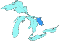
Georgian Bay (Ojibway: Manidoowi-zaaga`igan or Waasaagamaa) is a large bay of Lake Huron
, located entirely within Ontario
, Canada
. The main body of the bay lies east of the Bruce Peninsula
and Manitoulin Island
.
Georgian Bay is surrounded by (listed clockwise
) the districts of Manitoulin
, Sudbury
, Parry Sound
and Muskoka, as well as the more populous counties of Simcoe
, Grey
and Bruce
. The Main Channel separates the Bruce Peninsula from Manitoulin Island and connects Georgian Bay to the rest of Lake Huron. The North Channel
, located between Manitoulin Island and the Sudbury District, west of Killarney
, was once a popular route for steamships and is now used by a variety of pleasure craft
to travel to and from Georgian Bay.
The shores and waterways of the Georgian Bay are the traditional domain of the Anishinaabe
g First Nations
peoples to the North and Huron-Petun
(Wyandot) to the south. The bay was thus a major Algonquian
-Huron trade route. Samuel de Champlain
, the first European to explore and map the area in 1615–1616, called it "La Mer douce" (the calm sea), also a reference to the bay's freshwater. It was named "Georgian Bay" (after King George IV
) by Lieutenant Henry Wolsey Bayfield
of the Royal Navy
in 1822.
 Georgian Bay is about 220 kilometres (136.7 mi) long by 100 kilometres (62.1 mi) wide. It covers over 15000 square kilometres (5,791.5 sq mi), making it almost as large as Lake Ontario
. Eastern Georgian Bay is part of the southern edge of the Canadian Shield
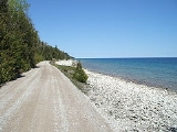
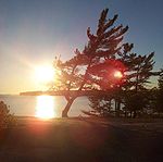
, granite bedrock exposed by the glaciers at the end of the last ice age
, about 11,000 years ago. The granite rock formations and windswept Eastern White Pine are characteristic of the islands and much of the shoreline of the bay. The rugged beauty of the area inspired landscapes by artists of the Group of Seven
. The western part of the bay, from Collingwood north, and including Manitoulin Island
, Drummond, Cockburn and St. Josephs Island, borders the Niagara Escarpment
.
There are tens of thousands of islands in Georgian Bay. Most of these islands are along the east side of the bay and are collectively known as the "Thirty Thousand Islands," including the larger Parry Island. Manitoulin Island, lying along the northern side of the bay, is the world's largest island in a freshwater lake. The Trent-Severn Waterway
connects Georgian Bay to Lake Ontario
, running from Port Severn in the southeastern corner of Georgian Bay through Lake Simcoe
into Lake Ontario near Trenton
. Further north, Lake Nipissing
drains into it through the French River
. In October 2004, the Georgian Bay Littoral
was declared a Biosphere Reserve
by UNESCO.
and near Killarney, Ontario
. At the time of European contact
, the Ojibwe
and Ottawa
First Nations
, both of whom call themselves Anishinaabe
(plural: Anishinaabeg), lived along the northern, eastern and western shores of Georgian Bay. The Huron (or Wendat) and Tionontati inhabited the lands along the southern coast, having migrated from the northern shores of Lake Ontario
. Names of islands such as Manitoulin (from Gitchi Manitou, the Great Spirit) and "Giant's Tomb" are indicative of the richness of the cultural history of the area. Aboriginal communities continue to live on their territories and practise their cultural traditions.
The first Europe
an to visit this area was likely Étienne Brûlé
, who at age less than 20, in 1610 was sent to live as an interpreter trainee with the Onontchataronon, an Algonquian
people of the Ottawa River. They travelled every winter to live with the Arendarhonon people of the Huron (Wendat) confederacy at the southern end of Georgian Bay, in the area now called Huronia
. Brulé returned to the Arendarhonon the following year. At the same time another young interpreter trainee, a youth remembered only as Thomas, who was employed by the French surgeon
and trader
Daniel Boyer, also likely made it to Huronia, in the company of the Onontchataronon, another member of the confederacy.
In 1615, Brulé's employer, the French
explorer Samuel de Champlain
, made his own visit to Georgian Bay and overwintered in Huronia. He was preceded that summer by a Récollet missionary
, Joseph Le Caron
, who would live among the Huron in 1615–1616 and 1623–1624. Another Récollet missionary, Gabriel Sagard, lived there from 1623–34. The French Jesuit Jean de Brébeuf
began a mission in Huronia in 1626. In 1639 he oversaw the building of the mission fort of Sainte-Marie
, Ontario's first Europe
an settlement, at what is now the town of Midland
.
The reconstructed Jesuit mission, Sainte-Marie among the Hurons
, is now a historic park operated by the province of Ontario. Also nearby is the Martyrs' Shrine
, a Catholic church dedicated to the Canadian Martyrs
, Jesuits who were killed during Iroquois
warfare against the Huron around Georgian Bay in the 17th century. Penetanguishene, an Ojibwe village located at the southern tip of the bay near present-day Midland, was developed as a naval base
in 1793 by John Graves Simcoe
, first Lieutenant Governor of Upper Canada.
In 1814, during the War of 1812
between Great Britain and the United States, one of the battles was fought in southern Georgian Bay. On August 17, at the mouth of the Nottawasaga River
near Wasaga Beach, the British schooner
HMS Nancy was sunk by three American vessels. Several weeks later, the Nancy was avenged when British boarding parties in the De Tour Passage
surprised and captured two American vessels.
Georgian Bay was first charted in 1815 by Captain William Fitzwilliam Owen
, who called it Lake Manitoulin. Captain Henry Bayfield, who made more detailed charts of the bay, renamed it in 1822 after King George IV
. His charts are the basis of those in use today.
and grabbing a large ball of earth. Running to the other end, he tossed it into the Great Lakes. Thus, the 30,000 Islands were created. The indentations left behind by his fingers form the five bays of Georgian Bay: Midland Bay, Penetang Bay, Hog Bay, Sturgeon Bay, and Matchedash Bay
. He then lay down to sleep and sleeps there still as Giant's Tomb Island
. There is a YMCA summer camp for youth located on Beausoleil Island, in Southern Georgian Bay, named after Kitchikewana. YMCA Camp Kitchikewana, or Kitchi for short, has been located in Georgian Bay Islands National park for over 90 years. Originally operated by the Midland YMCA, it is now the residential camp for youth from the YMCA of Simcoe/Muskoka.
 Owen Sound is the largest city on the bay, long having served as a shipping and rail depot for the Upper Great Lakes. The towns of Midland
and Penetanguishene, at the south-eastern end of the bay, are a popular site for summer cottages, as are the many bays and islands on the eastern coast. Collingwood
, Meaford
and Wasaga Beach
are located at the southern end of the bay, around Nottawasaga Bay
. Owen Sound and Wiarton
are located on the Bruce Peninsula along the southern and south-western shores of the bay, while Tobermory
is located at the northern tip of the Bruce Peninsula on the Main Channel. The passenger ferry MS Chi-Cheemaun
travels from Tobermory, across the Main Channel to South Baymouth on Manitoulin Island. Parry Sound
, the world's deepest freshwater port, is located on the eastern shore of the bay.
There are communities of summer cottages on the north and east shore and on the adjacent 30,000 Islands. These include areas such as Cognashene, Wah Wah Taysee, Sans Souci, Pointe au Baril
and Byng Inlet
. Most of these cottages are accessible only by water.
Lake Huron
Lake Huron is one of the five Great Lakes of North America. Hydrologically, it comprises the larger portion of Lake Michigan-Huron. It is bounded on the east by the Canadian province of Ontario and on the west by the state of Michigan in the United States...
, located entirely within Ontario
Ontario
Ontario is a province of Canada, located in east-central Canada. It is Canada's most populous province and second largest in total area. It is home to the nation's most populous city, Toronto, and the nation's capital, Ottawa....
, Canada
Canada
Canada is a North American country consisting of ten provinces and three territories. Located in the northern part of the continent, it extends from the Atlantic Ocean in the east to the Pacific Ocean in the west, and northward into the Arctic Ocean...
. The main body of the bay lies east of the Bruce Peninsula
Bruce Peninsula
The Bruce Peninsula is a peninsula in Ontario, Canada that lies between Georgian Bay and the main basin of Lake Huron. The peninsula extends roughly northwestwards from the rest of Southern Ontario, pointing towards Manitoulin Island, with which it forms the widest strait joining Georgian Bay to...
and Manitoulin Island
Manitoulin Island
Manitoulin Island is a Canadian island in Lake Huron, in the province of Ontario. It is the largest island in a freshwater lake in the world. In addition to the historic Anishinaabe and European settlement of the island, archeological discoveries at Sheguiandah have demonstrated Paleo-Indian and...
.
Georgian Bay is surrounded by (listed clockwise
Clockwise
Circular motion can occur in two possible directions. A clockwise motion is one that proceeds in the same direction as a clock's hands: from the top to the right, then down and then to the left, and back to the top...
) the districts of Manitoulin
Manitoulin District, Ontario
Manitoulin District is a district in Northeastern Ontario within the Canadian province of Ontario. It was created in 1888 from part of Algoma District. The district seat is Gore Bay....
, Sudbury
Sudbury District, Ontario
The Sudbury District is a district in Northeastern Ontario in the Canadian province of Ontario. It was created in 1894 from townships of eastern Algoma District and west Nipissing District....
, Parry Sound
Parry Sound District, Ontario
Parry Sound District is a census division of the Canadian province of Ontario. Its seat is Parry Sound. Its boundaries are Muskoka to the south, the Sudbury District, the French River and Lake Nipissing in the north, Nipissing District, Ontario and North Bay in the north and east and parts of...
and Muskoka, as well as the more populous counties of Simcoe
Simcoe County, Ontario
Simcoe County is located in central portion of Southern Ontario. The County is situated just north of the Greater Toronto Area stretching from the shores of Lake Simcoe in the east to Georgian Bay in the west...
, Grey
Grey County, Ontario
Grey County is a county and census division of the Canadian province of Ontario. The county seat is in Owen Sound. The population was 92,411 in 2006. It is located in the subregion of Southern Ontario named Southwestern Ontario...
and Bruce
Bruce County, Ontario
Bruce County is a county in western Ontario, Canada, and includes the Bruce Peninsula. As of 2006, the population was 65,349. The area was . The county seat is Walkerton, Ontario. It is located at ....
. The Main Channel separates the Bruce Peninsula from Manitoulin Island and connects Georgian Bay to the rest of Lake Huron. The North Channel
North Channel (Ontario)
The North Channel is the body of water along the north shore of Lake Huron, in the Canadian province of Ontario. It is bordered on the east by Georgian Bay, on the west by the St. Marys River, to the north by the eastern Algoma District and to the south by the islands of Manitoulin, Cockburn,...
, located between Manitoulin Island and the Sudbury District, west of Killarney
Killarney, Ontario
Killarney is a municipality located on the northern shore of Georgian Bay in the Sudbury District of Ontario. It is also the name of the largest community within the municipality...
, was once a popular route for steamships and is now used by a variety of pleasure craft
Pleasure craft
A pleasure craft is a boat used for personal, family, and sometimes sportsmanlike recreation. Typically such watercraft are motorized and are used for holidays, for example on a river, lake, canal or waterway. Pleasure craft are normally kept at a marina...
to travel to and from Georgian Bay.
The shores and waterways of the Georgian Bay are the traditional domain of the Anishinaabe
Anishinaabe
Anishinaabe or Anishinabe—or more properly Anishinaabeg or Anishinabek, which is the plural form of the word—is the autonym often used by the Odawa, Ojibwe, and Algonquin peoples. They all speak closely related Anishinaabemowin/Anishinaabe languages, of the Algonquian language family.The meaning...
g First Nations
First Nations
First Nations is a term that collectively refers to various Aboriginal peoples in Canada who are neither Inuit nor Métis. There are currently over 630 recognised First Nations governments or bands spread across Canada, roughly half of which are in the provinces of Ontario and British Columbia. The...
peoples to the North and Huron-Petun
Petun
The Petún , or Tionontati in their language, were an Iroquoian-speaking First Nations people closely related to the Wendat Confederacy. Their homeland was located along the southwest edge of Georgian Bay, in the area immediately to the west of the Huron territory in Southern Ontario of...
(Wyandot) to the south. The bay was thus a major Algonquian
Algonquian peoples
The Algonquian are one of the most populous and widespread North American native language groups, with tribes originally numbering in the hundreds. Today hundreds of thousands of individuals identify with various Algonquian peoples...
-Huron trade route. Samuel de Champlain
Samuel de Champlain
Samuel de Champlain , "The Father of New France", was a French navigator, cartographer, draughtsman, soldier, explorer, geographer, ethnologist, diplomat, and chronicler. He founded New France and Quebec City on July 3, 1608....
, the first European to explore and map the area in 1615–1616, called it "La Mer douce" (the calm sea), also a reference to the bay's freshwater. It was named "Georgian Bay" (after King George IV
George IV of the United Kingdom
George IV was the King of the United Kingdom of Great Britain and Ireland and also of Hanover from the death of his father, George III, on 29 January 1820 until his own death ten years later...
) by Lieutenant Henry Wolsey Bayfield
Henry Wolsey Bayfield
Admiral Henry Wolsey Bayfield was a British naval officer and surveyor.- Early life and career :Bayfield was born in Kingston-upon-Hull, to John Wolsey Bayfield and Eliza Petit. His family was an ancient one, who at one time lived at Bayfield Hall in Norfolk...
of the Royal Navy
Royal Navy
The Royal Navy is the naval warfare service branch of the British Armed Forces. Founded in the 16th century, it is the oldest service branch and is known as the Senior Service...
in 1822.
Geography
Lake Ontario
Lake Ontario is one of the five Great Lakes of North America. It is bounded on the north and southwest by the Canadian province of Ontario, and on the south by the American state of New York. Ontario, Canada's most populous province, was named for the lake. In the Wyandot language, ontarío means...
. Eastern Georgian Bay is part of the southern edge of the Canadian Shield
Canadian Shield
The Canadian Shield, also called the Laurentian Plateau, or Bouclier Canadien , is a vast geological shield covered by a thin layer of soil that forms the nucleus of the North American or Laurentia craton. It is an area mostly composed of igneous rock which relates to its long volcanic history...
, granite bedrock exposed by the glaciers at the end of the last ice age
Ice age
An ice age or, more precisely, glacial age, is a generic geological period of long-term reduction in the temperature of the Earth's surface and atmosphere, resulting in the presence or expansion of continental ice sheets, polar ice sheets and alpine glaciers...
, about 11,000 years ago. The granite rock formations and windswept Eastern White Pine are characteristic of the islands and much of the shoreline of the bay. The rugged beauty of the area inspired landscapes by artists of the Group of Seven
Group of Seven (artists)
The Group of Seven, sometimes known as the Algonquin school, were a group of Canadian landscape painters from 1920-1933, originally consisting of Franklin Carmichael , Lawren Harris , A. Y. Jackson , Franz Johnston , Arthur Lismer , J. E. H. MacDonald , and Frederick Varley...
. The western part of the bay, from Collingwood north, and including Manitoulin Island
Manitoulin Island
Manitoulin Island is a Canadian island in Lake Huron, in the province of Ontario. It is the largest island in a freshwater lake in the world. In addition to the historic Anishinaabe and European settlement of the island, archeological discoveries at Sheguiandah have demonstrated Paleo-Indian and...
, Drummond, Cockburn and St. Josephs Island, borders the Niagara Escarpment
Niagara Escarpment
The Niagara Escarpment is a long escarpment, or cuesta, in the United States and Canada that runs westward from New York State, through Ontario, Michigan, Wisconsin and Illinois...
.
There are tens of thousands of islands in Georgian Bay. Most of these islands are along the east side of the bay and are collectively known as the "Thirty Thousand Islands," including the larger Parry Island. Manitoulin Island, lying along the northern side of the bay, is the world's largest island in a freshwater lake. The Trent-Severn Waterway
Trent-Severn Waterway
The Trent–Severn Waterway is a Canadian canal system formerly used for industrial and transportation purposes and now for recreational and tourism purposes, connecting Lake Ontario at Trenton to the Georgian Bay portion of Lake Huron at Port Severn...
connects Georgian Bay to Lake Ontario
Lake Ontario
Lake Ontario is one of the five Great Lakes of North America. It is bounded on the north and southwest by the Canadian province of Ontario, and on the south by the American state of New York. Ontario, Canada's most populous province, was named for the lake. In the Wyandot language, ontarío means...
, running from Port Severn in the southeastern corner of Georgian Bay through Lake Simcoe
Lake Simcoe
Lake Simcoe is a lake in Southern Ontario, Canada, the fourth-largest lake wholly in the province, after Lake Nipigon, Lac Seul, and Lake Nipissing. At the time of the first European contact in the 17th century the lake was called Ouentironk by the Huron natives...
into Lake Ontario near Trenton
Trenton, Ontario
Trenton is a community in Southern Ontario in the municipality of Quinte West, Ontario, Canada. Located on the Bay of Quinte, it is the main population centre in Quinte West....
. Further north, Lake Nipissing
Lake Nipissing
Lake Nipissing is a lake in the Canadian province of Ontario. It has a surface area of , a mean elevation of above sea level, and is located between the Ottawa River and Georgian Bay. Excluding the Great Lakes, Lake Nipissing is the fifth-largest lake in Ontario. It is relatively shallow for a...
drains into it through the French River
French River (Ontario)
The French River is a river in Central Ontario, Canada. It flows from Lake Nipissing west to Georgian Bay. The river largely follows the boundary between the Parry Sound District and the Sudbury District, and in most contexts is considered the dividing line between Northern Ontario and Southern...
. In October 2004, the Georgian Bay Littoral
Georgian Bay Littoral
The Georgian Bay Littoral is a UNESCO Biosphere Reserve located in Ontario, Canada. The biosphere was the thirteenth in Canada, and covers the Thirty Thousand Islands area of eastern Georgian Bay, one of the world's largest fresh water archipelagos....
was declared a Biosphere Reserve
Biosphere reserve
The Man and the Biosphere Programme of UNESCO was established in 1971 to promote interdisciplinary approaches to management, research and education in ecosystem conservation and sustainable use of natural resources.-Development:...
by UNESCO.
History
Archeological records reveal an Aboriginal presence in the southern regions of the Canadian Shield dating from 11,000 years ago. Evidence of later paleo-Aboriginal settlements have been found on Manitoulin IslandManitoulin Island
Manitoulin Island is a Canadian island in Lake Huron, in the province of Ontario. It is the largest island in a freshwater lake in the world. In addition to the historic Anishinaabe and European settlement of the island, archeological discoveries at Sheguiandah have demonstrated Paleo-Indian and...
and near Killarney, Ontario
Killarney, Ontario
Killarney is a municipality located on the northern shore of Georgian Bay in the Sudbury District of Ontario. It is also the name of the largest community within the municipality...
. At the time of European contact
First contact (anthropology)
First contact is a term describing the first meeting of two cultures previously unaware of one another. One notable example of first contact is that between the Spanish and the Arawak in 1492....
, the Ojibwe
Ojibwa
The Ojibwe or Chippewa are among the largest groups of Native Americans–First Nations north of Mexico. They are divided between Canada and the United States. In Canada, they are the third-largest population among First Nations, surpassed only by Cree and Inuit...
and Ottawa
Ottawa (tribe)
The Odawa or Ottawa, said to mean "traders," are a Native American and First Nations people. They are one of the Anishinaabeg, related to but distinct from the Ojibwe nation. Their original homelands are located on Manitoulin Island, near the northern shores of Lake Huron, on the Bruce Peninsula in...
First Nations
First Nations
First Nations is a term that collectively refers to various Aboriginal peoples in Canada who are neither Inuit nor Métis. There are currently over 630 recognised First Nations governments or bands spread across Canada, roughly half of which are in the provinces of Ontario and British Columbia. The...
, both of whom call themselves Anishinaabe
Anishinaabe
Anishinaabe or Anishinabe—or more properly Anishinaabeg or Anishinabek, which is the plural form of the word—is the autonym often used by the Odawa, Ojibwe, and Algonquin peoples. They all speak closely related Anishinaabemowin/Anishinaabe languages, of the Algonquian language family.The meaning...
(plural: Anishinaabeg), lived along the northern, eastern and western shores of Georgian Bay. The Huron (or Wendat) and Tionontati inhabited the lands along the southern coast, having migrated from the northern shores of Lake Ontario
Lake Ontario
Lake Ontario is one of the five Great Lakes of North America. It is bounded on the north and southwest by the Canadian province of Ontario, and on the south by the American state of New York. Ontario, Canada's most populous province, was named for the lake. In the Wyandot language, ontarío means...
. Names of islands such as Manitoulin (from Gitchi Manitou, the Great Spirit) and "Giant's Tomb" are indicative of the richness of the cultural history of the area. Aboriginal communities continue to live on their territories and practise their cultural traditions.
The first Europe
Europe
Europe is, by convention, one of the world's seven continents. Comprising the westernmost peninsula of Eurasia, Europe is generally 'divided' from Asia to its east by the watershed divides of the Ural and Caucasus Mountains, the Ural River, the Caspian and Black Seas, and the waterways connecting...
an to visit this area was likely Étienne Brûlé
Étienne Brûlé
Étienne Brûlé , was the first of European French explorers to journey along the St. Lawrence River with the Native Americans and to view Georgian Bay and Lake Huron Canada in the 17th century. A rugged outdoorsman, he took to the lifestyle of the First Nations and had a unique contribution to the...
, who at age less than 20, in 1610 was sent to live as an interpreter trainee with the Onontchataronon, an Algonquian
Algonquian peoples
The Algonquian are one of the most populous and widespread North American native language groups, with tribes originally numbering in the hundreds. Today hundreds of thousands of individuals identify with various Algonquian peoples...
people of the Ottawa River. They travelled every winter to live with the Arendarhonon people of the Huron (Wendat) confederacy at the southern end of Georgian Bay, in the area now called Huronia
Wendake
Wendake may refer to:* the historical homeland of the Huron/Wendat/Wyandot nation, on the south shore of Georgian Bay in modern-day Simcoe and Grey counties in Ontario,...
. Brulé returned to the Arendarhonon the following year. At the same time another young interpreter trainee, a youth remembered only as Thomas, who was employed by the French surgeon
Surgeon
In medicine, a surgeon is a specialist in surgery. Surgery is a broad category of invasive medical treatment that involves the cutting of a body, whether human or animal, for a specific reason such as the removal of diseased tissue or to repair a tear or breakage...
and trader
Merchant
A merchant is a businessperson who trades in commodities that were produced by others, in order to earn a profit.Merchants can be one of two types:# A wholesale merchant operates in the chain between producer and retail merchant...
Daniel Boyer, also likely made it to Huronia, in the company of the Onontchataronon, another member of the confederacy.
In 1615, Brulé's employer, the French
France
The French Republic , The French Republic , The French Republic , (commonly known as France , is a unitary semi-presidential republic in Western Europe with several overseas territories and islands located on other continents and in the Indian, Pacific, and Atlantic oceans. Metropolitan France...
explorer Samuel de Champlain
Samuel de Champlain
Samuel de Champlain , "The Father of New France", was a French navigator, cartographer, draughtsman, soldier, explorer, geographer, ethnologist, diplomat, and chronicler. He founded New France and Quebec City on July 3, 1608....
, made his own visit to Georgian Bay and overwintered in Huronia. He was preceded that summer by a Récollet missionary
Missionary
A missionary is a member of a religious group sent into an area to do evangelism or ministries of service, such as education, literacy, social justice, health care and economic development. The word "mission" originates from 1598 when the Jesuits sent members abroad, derived from the Latin...
, Joseph Le Caron
Joseph Le Caron
Joseph Le Caron was one of the four pioneer missionaries of Canada , and the first missionary to the Hurons....
, who would live among the Huron in 1615–1616 and 1623–1624. Another Récollet missionary, Gabriel Sagard, lived there from 1623–34. The French Jesuit Jean de Brébeuf
Jean de Brébeuf
Jean de Brébeuf was a Jesuit missionary, martyred in Canada on March 16, 1649.-Early years:Brébeuf was born in Condé-sur-Vire, Normandy, France. He was the uncle of the fur trader Georges de Brébeuf. He studied near home at Caen. He became a Jesuit in 1617, joining the Order...
began a mission in Huronia in 1626. In 1639 he oversaw the building of the mission fort of Sainte-Marie
Sainte-Marie
Sainte-Marie is the name of several places. Sainte-Marie is French for Saint Mary.-In Metropolitan France:Sainte-Marie is the name or part of the name of several communes:*Sainte-Marie, Hautes-Alpes, in the Hautes-Alpes département...
, Ontario's first Europe
Europe
Europe is, by convention, one of the world's seven continents. Comprising the westernmost peninsula of Eurasia, Europe is generally 'divided' from Asia to its east by the watershed divides of the Ural and Caucasus Mountains, the Ural River, the Caspian and Black Seas, and the waterways connecting...
an settlement, at what is now the town of Midland
Midland, Ontario
Midland is a town located on Georgian Bay in Simcoe County, Ontario, Canada.Situated at the southern end of Georgian Bay's 30,000 Islands, Midland is the economic centre of the region, with a 125-bed hospital and a local airport. It is the main town of the southern Georgian Bay area...
.
The reconstructed Jesuit mission, Sainte-Marie among the Hurons
Sainte-Marie among the Hurons
Sainte-Marie among the Hurons was a French Jesuit settlement in Wendake, the land of the Wendat, near modern Midland, Ontario, from 1639 to 1649. It was the first European settlement in what is now the province of Ontario. Eight missionaries from Sainte-Marie were martyred, and were canonized by...
, is now a historic park operated by the province of Ontario. Also nearby is the Martyrs' Shrine
Martyrs' Shrine
The Martyrs’ Shrine is a Roman Catholic church in Midland, Ontario, Canada, which is consecrated to the memory of the Canadian Martyrs, six Jesuit Martyrs and two lay persons from the mission of Sainte-Marie among the Hurons. It is one of nine National Shrines in Canada,including, among others, St...
, a Catholic church dedicated to the Canadian Martyrs
Canadian Martyrs
The North American Martyrs, also known as the Canadian Martyrs or the Martyrs of New France, were eight Jesuit missionaries from Sainte-Marie among the Hurons, who were martyred in the mid-17th century in Canada, in what are now southern Ontario and upstate New York, during the warfare between the...
, Jesuits who were killed during Iroquois
Iroquois
The Iroquois , also known as the Haudenosaunee or the "People of the Longhouse", are an association of several tribes of indigenous people of North America...
warfare against the Huron around Georgian Bay in the 17th century. Penetanguishene, an Ojibwe village located at the southern tip of the bay near present-day Midland, was developed as a naval base
Naval base
A naval base is a military base, where warships and naval ships are deployed when they have no mission at sea or want to restock. Usually ships may also perform some minor repairs. Some naval bases are temporary homes to aircraft that usually stay on the ships but are undergoing maintenance while...
in 1793 by John Graves Simcoe
John Graves Simcoe
John Graves Simcoe was a British army officer and the first Lieutenant Governor of Upper Canada from 1791–1796. Then frontier, this was modern-day southern Ontario and the watersheds of Georgian Bay and Lake Superior...
, first Lieutenant Governor of Upper Canada.
In 1814, during the War of 1812
War of 1812
The War of 1812 was a military conflict fought between the forces of the United States of America and those of the British Empire. The Americans declared war in 1812 for several reasons, including trade restrictions because of Britain's ongoing war with France, impressment of American merchant...
between Great Britain and the United States, one of the battles was fought in southern Georgian Bay. On August 17, at the mouth of the Nottawasaga River
Nottawasaga River
The Nottawasaga River is a river in southern Ontario, Canada. Its headwaters are located on the Niagara Escarpment and Oak Ridges Moraine. It flows through the Minesing Swamp, recognized as a wetland of international significance , and empties into Nottawasaga Bay, an inlet of Georgian Bay, at...
near Wasaga Beach, the British schooner
Schooner
A schooner is a type of sailing vessel characterized by the use of fore-and-aft sails on two or more masts with the forward mast being no taller than the rear masts....
HMS Nancy was sunk by three American vessels. Several weeks later, the Nancy was avenged when British boarding parties in the De Tour Passage
De Tour Passage Underwater Preserve
The DeTour Passage Underwater Preserve is a preservation area in the U.S. state of Michigan. Located in Lake Huron, it completely surrounds Drummond Island and includes all of DeTour Passage and adjacent sections of Lake Huron and the St...
surprised and captured two American vessels.
Georgian Bay was first charted in 1815 by Captain William Fitzwilliam Owen
William Fitzwilliam Owen
Vice Admiral William Fitzwilliam Owen , was a British naval officer and explorer. He is best known for his exploration of the west and east African coasts, discovery of the Seaflower Channel off the coast of Sumatra and for surveying the Canadian Great Lakes...
, who called it Lake Manitoulin. Captain Henry Bayfield, who made more detailed charts of the bay, renamed it in 1822 after King George IV
George IV of the United Kingdom
George IV was the King of the United Kingdom of Great Britain and Ireland and also of Hanover from the death of his father, George III, on 29 January 1820 until his own death ten years later...
. His charts are the basis of those in use today.
Legend of Kitchikewana
Huron legend tells of a god called Kitchikewana, who was large enough to guard the whole of the Georgian Bay. Kitchikewana was known for his great temper and his tribe decided the best way to calm him was with a wife. They held a grand celebration, and many women came. Kitchikewana met a woman named Wanakita here. He decided that this was the woman he wanted to marry, and started planning the wedding immediately after she left. But when she was invited back, she told Kitchikewana that she was already engaged. Enraged, Kitchikewana destroyed all the decorations, running to one end of Beausoleil IslandBeausoleil Island
Beausoleil Island is a 8-kilometer long island in the Lake Huron's Georgian Bay, near Port Severn, Ontario. It is the largest island in the Georgian Bay Islands National Park and it offers island tent camping, overnight and day docking, heritage education programs, and hiking trails...
and grabbing a large ball of earth. Running to the other end, he tossed it into the Great Lakes. Thus, the 30,000 Islands were created. The indentations left behind by his fingers form the five bays of Georgian Bay: Midland Bay, Penetang Bay, Hog Bay, Sturgeon Bay, and Matchedash Bay
Matchedash Bay
Matchedash Bay is a bay and Ramsar wetland in Simcoe County in Central Ontario, Canada. It is the "final inland extension of Severn Sound" on Lake Huron's Georgian Bay, and is "situated at the interface between the Saint Lawrence Lowlands and the Canadian Shield ". It exhibits geologically unique...
. He then lay down to sleep and sleeps there still as Giant's Tomb Island
Giants Tomb Island
Giants Tomb Island is an island with no permanent residents located in Southern Georgian Bay in Ontario, Canada. It measures approximately 5 kilometres from north to south and 2 kilometres from east to west...
. There is a YMCA summer camp for youth located on Beausoleil Island, in Southern Georgian Bay, named after Kitchikewana. YMCA Camp Kitchikewana, or Kitchi for short, has been located in Georgian Bay Islands National park for over 90 years. Originally operated by the Midland YMCA, it is now the residential camp for youth from the YMCA of Simcoe/Muskoka.
Settlements
Midland, Ontario
Midland is a town located on Georgian Bay in Simcoe County, Ontario, Canada.Situated at the southern end of Georgian Bay's 30,000 Islands, Midland is the economic centre of the region, with a 125-bed hospital and a local airport. It is the main town of the southern Georgian Bay area...
and Penetanguishene, at the south-eastern end of the bay, are a popular site for summer cottages, as are the many bays and islands on the eastern coast. Collingwood
Collingwood, Ontario
Collingwood is a town in Simcoe County, Ontario, Canada. Geographically, it is situated on Nottawasaga Bay at the southern point of Georgian Bay.-History:...
, Meaford
Meaford, Ontario
Meaford is a Canadian municipality in Grey County, Ontario. Meaford is located on Nottawasaga Bay, a sub-basin of Georgian Bay, in southern Ontario....
and Wasaga Beach
Wasaga Beach, Ontario
Wasaga Beach is a town in Simcoe County, Ontario, Canada. It is a popular four-season tourist destination situated on Nottawasaga Bay at the southern end of Georgian Bay approximately two hours north of Toronto, and abuts, to the west, the town of Collingwood...
are located at the southern end of the bay, around Nottawasaga Bay
Nottawasaga Bay
Nottawasaga Bay is a bay of Lake Huron in Ontario, at the southernmost end of Georgian Bay. Communities on Nottawasaga Bay include Meaford, Collingwood and Wasaga Beach....
. Owen Sound and Wiarton
Wiarton, Ontario
Wiarton is a community in Bruce County, Ontario, at the western end of Colpoys Bay, an inlet off Georgian Bay, on the Bruce Peninsula. The community is part of the town of South Bruce Peninsula, Ontario....
are located on the Bruce Peninsula along the southern and south-western shores of the bay, while Tobermory
Tobermory, Ontario
Tobermory is a small community located at the northern tip of the Bruce Peninsula in the municipality of Northern Bruce Peninsula, Ontario, Canada. It is 300 km northwest of Toronto...
is located at the northern tip of the Bruce Peninsula on the Main Channel. The passenger ferry MS Chi-Cheemaun
Chi-Cheemaun
MS Chi-Cheemaun is a passenger and car ferry in Ontario, Canada, which traverses Lake Huron between Tobermory on Bruce Peninsula and South Baymouth on Manitoulin Island. The ferry connects the two geographically separate portions of Highway 6 and is the vessel that replaced MS Norgoma and SS...
travels from Tobermory, across the Main Channel to South Baymouth on Manitoulin Island. Parry Sound
Parry Sound, Ontario
Parry Sound is a town in Central Ontario, Canada, located on Parry Sound on the eastern shore of Georgian Bay. Parry Sound is located south of Sudbury and north of Toronto. It is the seat of Parry Sound District, a popular cottage country region for Southern Ontario residents. It is also the...
, the world's deepest freshwater port, is located on the eastern shore of the bay.
There are communities of summer cottages on the north and east shore and on the adjacent 30,000 Islands. These include areas such as Cognashene, Wah Wah Taysee, Sans Souci, Pointe au Baril
Pointe au Baril, Ontario
Pointe au Baril is a community in the Canadian province of Ontario, located on the east coast of Georgian Bay.The community is located in the township of The Archipelago in the Parry Sound District.-History of the name:...
and Byng Inlet
Byng Inlet (Ontario)
Byng Inlet is a body of water on the eastern shore of Georgian Bay, between Parry Sound and the mouth of the French River. It is a widening of the Magnetawan River, near its mouth...
. Most of these cottages are accessible only by water.
See also
- Canadian ShieldCanadian ShieldThe Canadian Shield, also called the Laurentian Plateau, or Bouclier Canadien , is a vast geological shield covered by a thin layer of soil that forms the nucleus of the North American or Laurentia craton. It is an area mostly composed of igneous rock which relates to its long volcanic history...
- Royal eponyms in CanadaRoyal eponyms in CanadaIn Canada, a number of sites and structures are named for royal individuals, whether a member of the past French Royal Family, British Royal Family, or present Canadian Royal Family, thus reflecting the country's status as a constitutional monarchy under the Canadian Crown.-King Francis I:-Queen...
- True North IITrue North IITrue North II was a small, 10.6 meter glass-bottom tour boat that sank on June 16, 2000, in of water off of Tobermory, Ontario, Canada, in Georgian Bay, while transporting a class of 13 students from an overnight field trip to Flowerpot Island back to the mainland. Two of the students,...
- Christian Island
External links
- Photo Gallery of Georgian Bay and Around, Georgian Bay Islands National Park of Canada, on the Government of Canada SiteGovernment of CanadaThe Government of Canada, formally Her Majesty's Government, is the system whereby the federation of Canada is administered by a common authority; in Canadian English, the term can mean either the collective set of institutions or specifically the Queen-in-Council...
- Georgian Bay Association.
- Georgian Bay Land Trust.
- Georgian Bay Biosphere Reserve.