

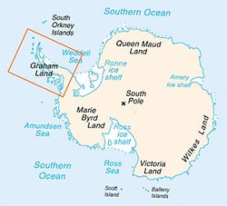
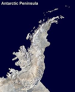
Antarctic Peninsula
Encyclopedia
Cape Adams
Cape Adams is an abrupt rock scarp marking the south tip of Bowman Peninsula and forming the north side of the entrance to Gardner Inlet, on the east coast of Palmer Land in Antarctica. It was discovered by the Ronne Antarctic Research Expedition , 1947–48, under Ronne, and named by him for Lt....
(Weddell Sea
Weddell Sea
The Weddell Sea is part of the Southern Ocean and contains the Weddell Gyre. Its land boundaries are defined by the bay formed from the coasts of Coats Land and the Antarctic Peninsula. The easternmost point is Cape Norvegia at Princess Martha Coast, Queen Maud Land. To the east of Cape Norvegia is...
) and a point on the mainland south of Eklund Islands
Eklund Islands
The Eklund Islands are a group of islands which rise through the ice near the southwest end of George VI Sound towards the south of the Antarctic Peninsula....
.
The Antarctic Peninsula is important because research has revealed that the forces of climate change
Climate change
Climate change is a significant and lasting change in the statistical distribution of weather patterns over periods ranging from decades to millions of years. It may be a change in average weather conditions or the distribution of events around that average...
are having a great effect on the region. The remote polar position has resulted in the area being dotted with numerous research stations and multiple claims of sovereignty. The peninsula
Peninsula
A peninsula is a piece of land that is bordered by water on three sides but connected to mainland. In many Germanic and Celtic languages and also in Baltic, Slavic and Hungarian, peninsulas are called "half-islands"....
forms part of disputed and overlapping claims by Argentina
Argentine Antarctica
Argentine Antarctica is a sector of Antarctica claimed by Argentina as part of its national territory. The Argentine Antarctic region, consisting of the Antarctic Peninsula and a triangular section extending to the South Pole, is delimited by the 25° West and 74° West meridians and the 60° South...
, Chile and the United Kingdom
British Antarctic Territory
The British Antarctic Territory is a sector of Antarctica claimed by the United Kingdom as one of its 14 British Overseas Territories. It comprises the region south of 60°S latitude and between longitudes and , forming a wedge shape that extends to the South Pole...
. None of these claims have international recognition and the respective countries do not currently actively pursue enforcement.
History
Discovery and naming
The first sighting of Antarctic Peninsula is disputed but apparently occurred in 1820. The most likely first sighting of the Antarctic mainland, which was also the Antarctic Peninsula, was probably during an expedition of the Russian Imperial Navy that was captained by Thaddeus von BellinghausenFabian Gottlieb von Bellingshausen
Fabian Gottlieb Thaddeus von Bellingshausen was an officer in the Imperial Russian Navy, cartographer and explorer, who ultimately rose to the rank of Admiral...
. The party did not recognize what they thought was an icefield covered by small hillocks as the mainland on 27 January 1820. Edward Bransfield
Edward Bransfield
Edward Bransfield was a master of the British Royal Navy and considered the discoverer of the continent of Antarctica.-Early life:...
and William Smith
William Smith (mariner)
William Smith was the English captain who discovered the South Shetland Islands, an archipelago off the Graham Land in Antarctica....
were the first to chart a part of the Antarctic Peninsula just three days later on the 30 January 1820. The location was later to be called Trinity Peninsula
Trinity Peninsula
Trinity Peninsula is the extreme northern portion of the Antarctic Peninsula, extending northeastward for about from a line connecting Cape Kjellman and Cape Longing. Dating back more than a century, chartmakers used various names for this portion of the Antarctic peninsula, each name having some...
, the extreme northeast portion of the peninsula. The next confirmed sighting was by John Biscoe
John Biscoe
John Biscoe was an English mariner and explorer who commanded the first expedition known to have sighted the areas named Enderby Land and Graham Land along the coast of Antarctica...
who named the northern part of the Antarctic Peninsula, Graham Land
Graham Land
Graham Land is that portion of the Antarctic Peninsula which lies north of a line joining Cape Jeremy and Cape Agassiz. This description of Graham Land is consistent with the 1964 agreement between the British Antarctic Place-names Committee and the US Advisory Committee on Antarctic Names, in...
, in 1832.
The first to make landing on the continent is also disputed. A 19th century seal hunter called John Davis
John Davis (sealer)
Captain John Davis was a seal hunter from Connecticut, USA who captained men who may have been the first to have set foot on Antarctica on 7 February 1821 shortly after the first sightings of the new continent by Fabian von Bellingshausen, Mikhail Petrovich Lazarev, Edward Bransfield and Nathaniel...
was almost certainly the first, however sealers were secretive about their movements and their ship logs were deliberately unreliable, in order to protect any new sealing grounds from competition.
Between 1901 and 1904, Otto Nordenskiöld
Otto Nordenskiöld
Nils Otto Gustaf Nordenskjöld was a Finnish and Swedish geologist, geographer, and polar explorer.-Biography:...
led the Swedish Antarctic Expedition
Swedish Antarctic Expedition
The Swedish Antarctic Expedition was led by Otto Nordenskjöld and Carl Anton Larsen.-Background:Otto Nordenskjöld, a Swedish geologist and geographer, organized and lead a scientific expedition of the Antarctic Peninsula...
, one of the first expeditions that was to explore parts of Antarctica. They landed on the Antarctic Peninsula in February 1902, aboard the Antarctica which later sank not far from the peninsula with all crew saved. They were later rescued by an Argentine ship. The British Graham Land Expedition
British Graham Land Expedition
A British expedition to Graham Land led by John Lachlan Cope took place between 1920 and 1922. The British Graham Land Expedition was a geophysical and exploration expedition to Graham Land in Antarctica between 1934 to 1937. Under the leadership of John Riddoch Rymill, the expedition spent two...
between 1934 and 1937 carried out aerial surveys and concluded that Graham Land was not an archipelago but was a peninsula.
Agreement on the name Antarctic Peninsula by the US-ACAN
Advisory Committee on Antarctic Names
The Advisory Committee on Antarctic Names is an advisory committee of the United States Board on Geographic Names responsible for recommending names for features in Antarctica...
and UK-APC in 1964 resolved a long-standing difference over the use of the American
United States
The United States of America is a federal constitutional republic comprising fifty states and a federal district...
name "Palmer Peninsula" or the British
United Kingdom
The United Kingdom of Great Britain and Northern IrelandIn the United Kingdom and Dependencies, other languages have been officially recognised as legitimate autochthonous languages under the European Charter for Regional or Minority Languages...
name "Graham Land" for this feature. (Graham Land is now that part of the Antarctic Peninsula northward of a line between Cape Jeremy
Cape Jeremy
Cape Jeremy is a cape marking the east side of the north entrance to George VI Sound and the west end of a line dividing Graham Land and Palmer Land. It was discovered by the British Graham Land Expedition , 1934–37, under Rymill, who named it for Jeremy Scott, son of J.M. Scott, who served as...
and Cape Agassiz
Cape Agassiz
Cape Agassiz is the east tip of Hollick-Kenyon Peninsula, a narrow ice-drowned spur extending east from the main mountain axis of Antarctic Peninsula between Mobiloil Inlet and Revelle Inlet. The cape is the east end of a line from Cape Jeremy dividing Graham Land and Palmer Land. It was...
, whilst Palmer Land
Palmer Land
Palmer Land is that portion of the Antarctic Peninsula which lies south of a line joining Cape Jeremy and Cape Agassiz. This application of Palmer Land is consistent with the 1964 agreement between US-ACAN and UK-APC, in which the name Antarctic Peninsula was approved for the major peninsula of...
is the part southward of that line. Palmer Land is named for the American seal hunter, Nathaniel Palmer
Nathaniel Palmer
Nathaniel Brown Palmer was an American seal hunter, explorer, sailing captain, and ship designer. He was born in Stonington, Connecticut.-Sealing career and Antarctic exploration:...
.) In Chile
Chile
Chile ,officially the Republic of Chile , is a country in South America occupying a long, narrow coastal strip between the Andes mountains to the east and the Pacific Ocean to the west. It borders Peru to the north, Bolivia to the northeast, Argentina to the east, and the Drake Passage in the far...
, the peninsula is officially referred as O'Higgins
Bernardo O'Higgins
Bernardo O'Higgins Riquelme was a Chilean independence leader who, together with José de San Martín, freed Chile from Spanish rule in the Chilean War of Independence. Although he was the second Supreme Director of Chile , he is considered one of Chile's founding fathers, as he was the first holder...
Land, after the Chilean patriot and Antarctic visionary. Other Spanish countries call it "Península Antártica", among them Argentina
Argentina
Argentina , officially the Argentine Republic , is the second largest country in South America by land area, after Brazil. It is constituted as a federation of 23 provinces and an autonomous city, Buenos Aires...
(while also calling it "Tierra de San Martín"), which has more bases and personnel there than any other nation.
Other portions of the peninsula that were named after various expeditions made their discovery include Bowman Coast
Bowman Coast
The Bowman Coast is the portion of the east coast of the Antarctic Peninsula between Cape Northrop and Cape Agassiz. It was discovered by Sir Hubert Wilkins in an aerial flight of December 20, 1928. It was named by Wilkins for Isaiah Bowman, then Director of the American Geographical Society....
, Black Coast
Black Coast
Black Coast is the portion of the east coast of the Antarctic Peninsula between Cape Boggs and Cape Mackintosh. This coast was discovered and photographed from the air by members of the East Base of the U.S. Antarctic Service, 1939–41, on a flight of December 30, 1940...
, Danco Coast
Danco Coast
Danco Coast is that portion of the west coast of the Antarctic Peninsula between Cape Sterneck and Cape Renard. This coast was explored in January and February 1898 by the Belgian Antarctic Expedition under Gerlache, who named it for Lieutenant Emile Danco who died on the expedition....
, Davis Coast
Davis Coast
Davis Coast is that portion of the west coast of the Antarctic Peninsula between Cape Kjellman and Cape Sterneck. It was named by the Advisory Committee on Antarctic Names for Captain John Davis, the American sealer who claimed to have made the first recorded landing on the continent of...
, English Coast
English Coast
English Coast is that portion of the coast of Antarctica between the north tip of Rydberg Peninsula and Buttress Nunataks . To the west is Bryan Coast, and northward runs Rymill Coast east of Alexander Island across George VI Sound. This coast was discovered and explored in 1940, on land by Finn...
, Fallieres Coast
Fallieres Coast
Fallières Coast is that portion of the west coast of the Antarctic Peninsula between the head of Bourgeois Fjord and Cape Jeremy and lies on Marguerite Bay and the Wordie Ice Shelf. On the south it is joined by Rymill Coast, and in the north by Loubet Coast. Fallières Coast was first explored in...
, Loubet Land
Loubet Land
Loubet Coast is the portion of the west coast of Graham Land in Antarctic Peninsula, extending 158 km between Cape Bellue to the northeast and Bourgeois Fjord to the southwest...
, Nordenskjold Coast
Nordenskjold Coast
Nordenskjold Coast is that portion of the east coast of the Antarctic Peninsula between Cape Longing and Cape Fairweather. The name was proposed in 1909 by Edwin Swift Balch, for Otto Nordenskiöld, Swedish geographer and leader of the Swedish Antarctic Expedition, 1901-04, who explored this coast...
and the Wilkins Coast
Wilkins Coast
Wilkins Coast is that portion of the east coast of the Antarctic Peninsula between Cape Agassiz and Cape Boggs. It was named by the Advisory Committee on Antarctic Names for Sir Hubert Wilkins, who in a pioneer Antarctic exploratory flight on December 20, 1928, flew southward from Deception...
.
Recent
The RRS BransfieldRRS Bransfield
RRS Bransfield was an ice-strengthened cargo vessel, purpose-built for the British Antarctic Survey .-History:RRS Bransfield was designed by consultants Graham & Woolnaugh of Liverpool for NERC, and built by Robb Caledon Shipbuilders Ltd, Leith...
was the name of the ship that transported the secret British expedition to Antarctica during World War Two, during which the first permanent British bases on the Antarctic Peninsula were established. Tourism to the Antarctic Peninsula begin in the 1950s. Most ship-based tourists depart for the peninsula from Puerto Williams
Puerto Williams
Puerto Williams is a Chilean port, located on Isla Navarino facing the Beagle Channel. It is the capital of the Chilean Antarctic Province, one of four provinces located in the Magellan and Chilean Antartica Region...
in Chile
Chile
Chile ,officially the Republic of Chile , is a country in South America occupying a long, narrow coastal strip between the Andes mountains to the east and the Pacific Ocean to the west. It borders Peru to the north, Bolivia to the northeast, Argentina to the east, and the Drake Passage in the far...
.
Argentina's Esperanza Base
Esperanza Base
-References:*Antarctica. Sydney: Reader's Digest, 1985, p. 156-157.*Child, Jack. Antarctica and South American Geopolitics: Frozen Lebensraum. New York: Praeger Publishers, 1988, p. 73....
was the birthplace of Emilio Marcos Palma, the first person to be born in Antarctica. The dinosaur species Antarctopelta
Antarctopelta
Antarctopelta was a genus of ankylosaurian dinosaur with one known species, A. oliveroi, which lived in Antarctica during the Late Cretaceous Period. It was a medium-sized ankylosaur, reaching no more than 4 meters in length, and showed characteristics of two different families, making more...
was the first dinosaur fossil to be found on the continent, in January 1986 on James Ross Island
James Ross Island
James Ross Island is a large island off the southeast side and near the northeastern extremity of Antarctic Peninsula, from which it is separated by Prince Gustav Channel. Rising to , it is irregularly shaped and extends in a north-south direction. It was charted in October 1903 by the Swedish...
, off the Antarctic Peninsula.
The grounding of the Argentine ship Bahía Paraíso and subsequent 170,000 gallon oil spill
Oil spill
An oil spill is the release of a liquid petroleum hydrocarbon into the environment, especially marine areas, due to human activity, and is a form of pollution. The term is mostly used to describe marine oil spills, where oil is released into the ocean or coastal waters...
occurred near the Antarctic Peninsula in 1989. In 2005, Lewis Gordon Pugh
Lewis Gordon Pugh
Lewis Gordon Pugh, OIG is a British environmental campaigner, maritime lawyer and endurance swimmer.Pugh was the first person to complete a long distance swim in every ocean...
broke the farthest-south long distance swim record by undertaking a 1 km (0.621372736649807 mi) swim at Petermann Island
Petermann Island
Petermann Island is a small island just off the west side of the Antarctic Peninsula of Antarctica, located at , just a short distance south of Booth Island and the Lemaire Channel...
off the Antarctic Peninsula. In November 2007, the MS Explorer
MS Explorer
The MS Explorer was a Liberian-registered cruise ship designed for Arctic and Antarctic service, originally commissioned and operated by the Swedish explorer Lars-Eric Lindblad...
rammed submerged sea ice and then sank after water from a fist sized hole could not be pumped out quickly enough. All passengers and crew were safely evacuated and rescued.
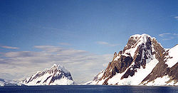
Geography
Mount Castro
Mount Castro is a mountain, high, on the north side of Seller Glacier, southeast of Mount Gilbert, in the central Antarctic Peninsula. It was photographed from the air by the British Graham Land Expedition in 1937, and by the Ronne Antarctic Research Expedition in 1947...
, Mount Coman
Mount Coman
Mount Coman is a prominent isolated mountain which rises above the ice-covered plateau of Palmer Land, located just westward of the Playfair Mountains in Antarctica. It was discovered by the Ronne Antarctic Research Expedition, 1947–48, under Finn Ronne, who named this mountain for Dr. F. Dana...
, Mount Gilbert
Mount Gilbert (Antarctica)
Mount Gilbert is a mountain on the divide between Airy Glacier and Seller Glacier, northwest of Mount Castro, in the west-central Antarctic Peninsula....
, Mount Jackson
Mount Jackson (Antarctica)
Mount Jackson is a massive mountain that dominates the upland in the southern part of the Antarctic Peninsula. It rises to a majestic summit peak on south and east, while the north flank is occupied by a vast cirque. Alternate names for the mountain include Mount Andrew Jackson and Mount Ernest...
, Mount William, Mount Owen
Mount Owen (Antarctica)
Mount Owen is a mountain on the eastern coast of Palmer Land on the Antarctic Peninsula. It stands 1,105 m in height, and was named by Ronne for Arthur Owen, a member of the Ronne Antarctic Research Expedition....
and Mount Scott. These mountains are considered to be a continuation of the Andes
Andes
The Andes is the world's longest continental mountain range. It is a continual range of highlands along the western coast of South America. This range is about long, about to wide , and of an average height of about .Along its length, the Andes is split into several ranges, which are separated...
of South America
South America
South America is a continent situated in the Western Hemisphere, mostly in the Southern Hemisphere, with a relatively small portion in the Northern Hemisphere. The continent is also considered a subcontinent of the Americas. It is bordered on the west by the Pacific Ocean and on the north and east...
, with a submarine spine or ridge
Mid-ocean ridge
A mid-ocean ridge is a general term for an underwater mountain system that consists of various mountain ranges , typically having a valley known as a rift running along its spine, formed by plate tectonics. This type of oceanic ridge is characteristic of what is known as an oceanic spreading...
connecting the two. This is the basis for the position advanced by Chile
Chile
Chile ,officially the Republic of Chile , is a country in South America occupying a long, narrow coastal strip between the Andes mountains to the east and the Pacific Ocean to the west. It borders Peru to the north, Bolivia to the northeast, Argentina to the east, and the Drake Passage in the far...
and Argentina
Argentina
Argentina , officially the Argentine Republic , is the second largest country in South America by land area, after Brazil. It is constituted as a federation of 23 provinces and an autonomous city, Buenos Aires...
for their territorial claims. The Scotia Arc
Scotia Arc
Scotia Arc is the island arc system forming the north, east and south border of Scotia Sea. The arc comprises submarine ridges and the island groups of South Orkneys, South Sandwich Islands, Clerke Rocks, South Georgia, Shag Rocks, Isla de los Estados, and Burwood Bank linking the mountains of...
is the island arc system that links the mountains of the Antarctic Peninsula to those of Tierra del Fuego
Tierra del Fuego
Tierra del Fuego is an archipelago off the southernmost tip of the South American mainland, across the Strait of Magellan. The archipelago consists of a main island Isla Grande de Tierra del Fuego divided between Chile and Argentina with an area of , and a group of smaller islands including Cape...
.
The landscape of the peninsula is typical Antarctic tundra. The peninsula has a sharp elevation gradient, with glacier
Glacier
A glacier is a large persistent body of ice that forms where the accumulation of snow exceeds its ablation over many years, often centuries. At least 0.1 km² in area and 50 m thick, but often much larger, a glacier slowly deforms and flows due to stresses induced by its weight...
s flowing into the Larsen Ice Shelf
Larsen Ice Shelf
The Larsen Ice Shelf is a long, fringing ice shelf in the northwest part of the Weddell Sea, extending along the east coast of Antarctic Peninsula from Cape Longing to the area just southward of Hearst Island...
, which experienced significant breakup in 2002. Other ice shelves on the peninsular include George VI Ice Shelf
George VI Ice Shelf
The George VI Ice Shelf is an extensive ice shelf that occupies George VI Sound between Alexander Island and Palmer Land in Antarctica. The ice shelf extends from Ronne Entrance, at the southwest end of the sound, to Niznik Island, about south of the north entrance between Cape Brown and Cape...
, Wilkins Ice Shelf, Wordie Ice Shelf
Wordie Ice Shelf
The Wordie Ice Shelf was a confluent glacier projecting as an ice shelf into the SE part of Marguerite Bay between Cape Berteaux and Mount Edgell, along the western coast of Antarctic Peninsula....
and the Bach Ice Shelf
Bach Ice Shelf
The Bach Ice Shelf is an ice shelf which is irregular in shape and in extent, occupying an embayment in the south part of Alexander Island entered between Berlioz Point and Rossini Point. A minor embayment in this position first appeared on the charts of the US Antarctic Service, which explored...
. The Filchner-Ronne Ice Shelf
Filchner-Ronne Ice Shelf
The Filchner-Ronne Ice Shelf, also known as Ronne-Filchner Ice Shelf, is an Antarctic ice shelf bordering the Weddell Sea.-Description:...
lies to the east of the peninsula.
Islands along the peninsula are mostly ice covered and connected to the land by pack ice. Separating the peninsula from nearby islands is the Antarctic Sound
Antarctic Sound
Antarctic Sound is a body of water about long and from wide, separating the Joinville Island group from the northeast end of the Antarctic Peninsula. The sound was named by the Swedish Antarctic Expedition under Otto Nordenskiöld for the expedition ship Antarctic which in 1902, under the command...
, Erebus and Terror Gulf
Erebus and Terror Gulf
Erebus and Terror Gulf is a gulf on the southeast side of the tip of Antarctic Peninsula, bordered on the northeast by the Joinville Island group and on the southwest by the James Ross Island group. Named for HMS Erebus and HMS Terror, two British ships, who explored Antarctic waters in 1842-43...
, George VI Sound
George VI Sound
George VI Sound or Canal Jorge VI or Canal Presidente Sarmiento or Canal Seaver or King George VI Sound or King George the Sixth Sound is a major bay/fault depression, 300 miles long in the shape of the letter J, which skirts the east and south shores of Alexander Island, separating it from the...
, Gerlache Strait
Gerlache Strait
Gerlache Strait or De Gerlache Strait or Détroit de la Belgica is a channel/strait separating the Palmer Archipelago from the Antarctic Peninsula. The Belgian Antarctic Expedition, under Lt. Adrien de Gerlache, explored the strait in January and February 1898, naming it for the expedition ship...
and the Lemaire Channel
Lemaire Channel
Lemaire Channel is a strait off Antarctica, located between Kiev Peninsula in the mainland's Graham Land and Booth Island. Nicknamed "Kodak Gap" by some, it is one of the top tourist destinations in Antarctica; steep cliffs hem in the iceberg-filled passage, which is 11 km long and just 1,600...
. The Lemaire Channel is a popular destination for tourist cruise ships that visit Antactica. Further to the west lies the Bellingshausen Sea
Bellingshausen Sea
The Bellingshausen Sea is an area along the west side of the Antarctic Peninsula, west of Alexander Island, east of Cape Flying Fish on Thurston Island, and south of Peter I Island . In the south are, from west to east, Eights Coast, Bryan Coast and English Coast of West Antarctica...
and in the north is the Scotia Sea
Scotia Sea
The Scotia Sea is partly in the Southern Ocean and mostly in the South Atlantic Ocean.-Location and description:Habitually stormy and cold, the Scotia Sea is the area of water between Tierra del Fuego, South Georgia, South Sandwich Islands, South Orkney Islands and the Antarctic Peninsula, and...
. The Antarctic Peninsula and Cape Horn
Cape Horn
Cape Horn is the southernmost headland of the Tierra del Fuego archipelago of southern Chile, and is located on the small Hornos Island...
create a funneling effect, which channels the winds into the relatively narrow Drake Passage
Drake Passage
The Drake Passage or Mar de Hoces—Sea of Hoces—is the body of water between the southern tip of South America at Cape Horn, Chile and the South Shetland Islands of Antarctica...
.
Hope Bay
Hope Bay
Hope Bay on Trinity Peninsula, is long and wide, indenting the tip of Antarctic Peninsula and opening on Antarctic Sound....
, at 63°23′S 057°00′W, is near to the northernmost extremity of the peninsula, which is Prime Head, at 63º13'S. Near the tip at Hope Bay is Sheppard Point
Sheppard Point
Sheppard Point is a point marking the north side of the entrance to Hope Bay, at the northeast end of Antarctic Peninsula. Discovered by a party under J. Gunnar Andersson of the Swedish Antarctic Expedition, 1901–04, who wintered at Hope Bay in 1903. Named by the Falkland Islands Dependencies...
. The part of the Antarctic Peninsula extending northeastwards from a line connecting Cape Kater
Cape Kater
Cape Kater is a cape fringed by rocks, marking the west side of the entrance to Charcot Bay on the west coast of Graham Land. This coast was sketched by a British expedition 1828-31, under Foster, who named a cape in this region after Captain Henry Kater, a member of the committee which planned...
to Cape Longing
Cape Longing
Cape Longing is a rocky cape on the east coast of Graham Land, forming the south end of a large ice-covered promontory which marks the west side of the south entrance to Prince Gustav Channel...
is called the Trinity Peninsula. Brown Bluff
Brown Bluff
Brown Bluff is a tuya located at the northern tip of the Antarctic Peninsula, Antarctica. It formed in the past 1 million years, which erupted subglacially within an englacial lake. The volcano's original diameter is thought to have been about 12-15 kilometers, and probably formed by a single vent...
is a rare tuya
Tuya
A tuya is a type of distinctive, flat-topped, steep-sided volcano formed when lava erupts through a thick glacier or ice sheet. They are somewhat rare worldwide, being confined to regions which were covered by glaciers and also had active volcanism during the same time period.-Formation:Tuyas are...
and Sheppard Nunatak
Sheppard Nunatak
Sheppard Nunatak is a conical nunatak 60 m high which stands close north of Sheppard Point, the north side of the entrance to Hope Bay, at the northeast end of Antarctic Peninsula. This area was first explored by a party of the Swedish Antarctic Expedition 1901-04...
is found here also. The Airy Glacier
Airy Glacier
The Airy Glacier is a glacier long and wide, flowing west to the northeast portion of Forster Ice Piedmont, near the west coast of the Antarctic Peninsula....
, Seller Glacier
Seller Glacier
Seller Glacier is a well-defined glacier, 20 nautical miles long and 4 nautical miles wide flowing westward into Forster Ice Piedmont, western Antarctic Peninsula, just north of Flinders Peak...
, Fleming Glacier
Fleming Glacier
Fleming Glacier is a broad glacier 25 nautical miles long on the west side of Antarctic Peninsula, flowing west-northwest and terminating in Forster Ice Piedmont to the east of Wordie Ice Shelf...
and Prospect Glacier
Prospect Glacier
Prospect Glacier is a glacier between Kinnear Mountains and Mayer Hills, flowing north into Forster Ice Piedmont on the west coast of Antarctic Peninsula. First roughly surveyed in 1936 by the British Graham Land Expedition under Rymill...
s form the Forster Ice Piedmont
Forster Ice Piedmont
The Forster Ice Piedmont is an ice piedmont lying landward of the Wordie Ice Shelf, along the west coast of the Antarctic Peninsula.The piedmont is formed by the confluence of Airy, Seller, Fleming and Prospect Glaciers and is about 25 miles long from north to south and 12 miles wide...
along the west coast of the Antarctic Peninsula. Charlotte Bay
Charlotte Bay
Charlotte Bay is a bay on the west coast of the Antarctic Peninsula indenting the west coast of Graham Land in a southeast direction for , between Reclus Peninsula and Cape Murray...
, Hughes Bay
Hughes Bay
Hughes Bay is the 42 km wide bay indenting for 20 km Danco Coast on the west side of Graham Land, Antarctica, lying south of Chavdar Peninsula and north of Pefaur Peninsula, and entered between Cape Sterneck and Cape Murray....
and Marguerite Bay
Marguerite Bay
Marguerite Bay or Margaret Bay is an extensive bay on the west side of the Antarctic Peninsula, which is bounded on the north by Adelaide Island and on the south by Wordie Ice Shelf, George VI Sound and Alexander Island. The mainland coast on the Antarctic Peninsula is Fallières Coast. Islands...
are located on the west coast as well.
On the east coast is the Athene Glacier
Athene Glacier
Athene Glacier is a glacier, long, flowing east and merging with the terminus of Casey Glacier where it discharges into Casey Inlet, on the east coast of the Antarctic Peninsula. It was photographed from the air by the Falkland Islands Dependencies Survey in August 1947, and by the Ronne...
while the Arctowski Nunatak
Arctowski Nunatak
Arctowski Nunatak is a nunatak northwest of Hertha Nunatak in the Seal Nunataks group, off the east coast of the Antarctic Peninsula. It was charted by the Swedish Antarctic Expedition under Otto Nordenskiöld during a sledge journey in 1902, and named by him for Henryk Arctowski, Polish...
and Akerlundh Nunatak
Akerlundh Nunatak
Åkerlundh Nunatak is a nunatak which lies northwest of Donald Nunatak between Bruce Nunatak and Murdoch Nunatak in the Seal Nunataks group, off the east coast of Antarctic Peninsula. Charted in 1947 by the Falkland Islands Dependencies Survey, who named it for Gustaf Åkerlundh, a member of the...
are both located just off the east coast. A number of smaller peninsulas extend from the main Antarctic Peninsula including Hollick-Kenyon Peninsula
Hollick-Kenyon Peninsula
Hollick-Kenyon Peninsula , an ice-covered spur from the main mountain mass of the Antarctic Peninsula, projects over 40 miles in a northeast arc from its base between Mobiloil Inlet and Casey Inlet...
and Prehn Peninsula
Prehn Peninsula
The mainly ice-covered Prehn Peninsula is 32 km long and 16 km wide, between Hansen and Gardner Inlets, on the eastern coast and at the base of Antarctic Peninsula. First observed from aircraft by the RARE, 1947-48. Mapped by USGS from surveys and US Navy air photos, 1961-67. Named by...
at the base of the Antarctic Peninsula. Also located here are the Scaife Mountains
Scaife Mountains
The Scaife Mountains is a group of mountains rising west of Prehn Peninsula and between the Ketchum and Ueda glaciers, in Palmer Land, at the base of Antarctic Peninsula....
. The Eternity Range
Eternity Range
Eternity Range is a range of mountains 28 miles long, rising 2,860 m, and trending north-south approximately in the middle of the Antarctic Peninsula....
is found in the middle of the peninsula. Other geographical features include Avery Plateau
Avery Plateau
Avery Plateau is an ice-covered plateau, about long and rising to about , midway between Loubet Coast and Foyn Coast in Graham Land. The first sighting of this plateau is not ascertained, but it was presumably seen in January and February of 1909 by members of the French Antarctic Expedition...
, the twin towers of Una's Tits
Una's Tits
Una's Tits are two towers of basalt, each topped by a cap of ice, guarding the entrance to the Lemaire Channel on the Antarctic Peninsula. With a highest summit is 747 m high, they are officially named "Una's Tits" and are identified as such on navigation charts...
.
Climate change
Ice mass loss on the peninsula occurred at a rate of 60 billion tonnes in 2006, with the greatest change occurring in the northern tip of the peninsula. Seven ice shelves along the Antarctic Peninsula have retreated or disintegrated in the last two decades. Research by the United States Geological Survey
United States Geological Survey
The United States Geological Survey is a scientific agency of the United States government. The scientists of the USGS study the landscape of the United States, its natural resources, and the natural hazards that threaten it. The organization has four major science disciplines, concerning biology,...
has revealed that every ice front on the southern half of the peninsula experienced a retreat between 1947 and 2009.
According to a study by the British Antarctic Survey
British Antarctic Survey
The British Antarctic Survey is the United Kingdom's national Antarctic operation and has an active role in Antarctic affairs. BAS is part of the Natural Environment Research Council and has over 400 staff. It operates five research stations, two ships and five aircraft in and around Antarctica....
, glaciers on the peninsula are not only retreating but also increasing their flow rate as a result of increased buoyancy
Buoyancy
In physics, buoyancy is a force exerted by a fluid that opposes an object's weight. In a column of fluid, pressure increases with depth as a result of the weight of the overlying fluid. Thus a column of fluid, or an object submerged in the fluid, experiences greater pressure at the bottom of the...
in the lower parts of the glaciers. Professor David Vaughan has described the disintegration of the Wilkins Ice Shelf as the latest evidence of rapid warming in the area. The Intergovernmental Panel on Climate Change
Intergovernmental Panel on Climate Change
The Intergovernmental Panel on Climate Change is a scientific intergovernmental body which provides comprehensive assessments of current scientific, technical and socio-economic information worldwide about the risk of climate change caused by human activity, its potential environmental and...
has been unable to determine the greatest potential effect on sea level rise that glaciers in the region may cause.
Research stations
Since the peninsula has the mildest climate in Antarctica, the highest concentration of research station
Research station
A research station is a station built for the purpose of conducting scientific research. Research station sites might include outer space and oceans. Many nations have research stations in Antarctica; Showa Station, Halley and Troll are examples...
s on the continent can be found there, or on the many nearby islands, and it is the part of Antarctica most often visited by tour vessels and yachts. Occupied bases include Base General Bernardo O'Higgins Riquelme
Base General Bernardo O'Higgins Riquelme
Base General Bernardo O'Higgins Riquelme, also Base Libertador General Bernardo O'Higgins Riquelme, or shortly Bernardo O'Higgins, named after Bernardo O'Higgins is a permanently staffed Chilean base in Antarctica. It is located at , at an elevation of 13 m, about 30 km southwest of Prime...
, Bellingshausen Station
Bellingshausen Station
thumb|right|Bellingshausen is one of Antarctica's most polluted places. Old vehicles, rusting barrels and other refuse litter the shorelinethumb|right|Muddy scene around the base. On the hilltop an orthodox church was built in 2004...
, Comandante Ferraz Brazilian Antarctic Base
Comandante Ferraz Brazilian Antarctic Base
The Comandante Ferraz Brazilian Antarctic Base is a Brazilian research station located in Admiralty Bay, King George Island, near the tip of the Antarctic Peninsula....
, Rothera Research Station
Rothera Research Station
Rothera research station is a British Antarctic Survey base on the Antarctic Peninsula, located at Rothera Point, Adelaide Island. Rothera also serves as the capital of the British Overseas Territory, the British Antarctic Territory....
and San Martín Base
San Martín Base
The San Martín Base is an Argentine base in Antarctica, operated by the Instituto Antartico Argentino and located on the Barry Island near the Antarctic Peninsula's mountain range. It was founded on March 21, 1951 by Argentine Army Colonel D. H. Pujato, who named the base after the Argentine...
. Today, on the Antarctic Peninsula there are many abandoned scientific and military bases. Ice core
Ice core
An ice core is a core sample that is typically removed from an ice sheet, most commonly from the polar ice caps of Antarctica, Greenland or from high mountain glaciers elsewhere. As the ice forms from the incremental build up of annual layers of snow, lower layers are older than upper, and an ice...
and sediment samples from the peninsula are valuable because events such as the Little Ice Age
Little Ice Age
The Little Ice Age was a period of cooling that occurred after the Medieval Warm Period . While not a true ice age, the term was introduced into the scientific literature by François E. Matthes in 1939...
can be verified with samples from other continents.
Flora and fauna

Gondwana
In paleogeography, Gondwana , originally Gondwanaland, was the southernmost of two supercontinents that later became parts of the Pangaea supercontinent. It existed from approximately 510 to 180 million years ago . Gondwana is believed to have sutured between ca. 570 and 510 Mya,...
. The coasts of the peninsula have the mildest climate in Antarctica and moss and lichen-covered rocks are free of snow during the summer months, although the weather is still intensely cold and the growing season very short. The plant life today is mainly moss
Moss
Mosses are small, soft plants that are typically 1–10 cm tall, though some species are much larger. They commonly grow close together in clumps or mats in damp or shady locations. They do not have flowers or seeds, and their simple leaves cover the thin wiry stems...
es, lichen
Lichen
Lichens are composite organisms consisting of a symbiotic organism composed of a fungus with a photosynthetic partner , usually either a green alga or cyanobacterium...
s and algae
Algae
Algae are a large and diverse group of simple, typically autotrophic organisms, ranging from unicellular to multicellular forms, such as the giant kelps that grow to 65 meters in length. They are photosynthetic like plants, and "simple" because their tissues are not organized into the many...
adapted to this harsh environment, with lichens preferring the wetter areas of the rocky landscape. The most common lichens are Usnea
Usnea
Usnea is the generic and scientific name for several species of lichen in the family Parmeliaceae, that generally grow hanging from tree branches, resembling grey or greenish hair. It is sometimes referred to commonly as Old Man's Beard, Beard Lichen, or Treemoss...
and Bryoria
Bryoria
Bryoria is a genus of lichenized fungi within the Parmeliaceae family. The genus has a widespread distribution, especially in boreal and cool temperate areas, and contains 51 species.-Species:*Bryoria bicolor*Bryoria capillaris...
species. Antarctica's two flowering plant species, the Antarctic hair grass (Deschampsia antarctica) and Antarctic pearlwort (Colobanthus quitensis) are found on the northern and western parts of the Antarctic Peninsula, including offshore islands, where the climate is relatively mild. Lagotellerie Island in Marguerite Bay
Marguerite Bay
Marguerite Bay or Margaret Bay is an extensive bay on the west side of the Antarctic Peninsula, which is bounded on the north by Adelaide Island and on the south by Wordie Ice Shelf, George VI Sound and Alexander Island. The mainland coast on the Antarctic Peninsula is Fallières Coast. Islands...
is an example of this habitat.
Antarctic krill
Antarctic krill
Antarctic krill, Euphausia superba, is a species of krill found in the Antarctic waters of the Southern Ocean. It is a shrimp-like crustacean that lives in large schools, called swarms, sometimes reaching densities of 10,000–30,000 individual animals per cubic metre...
are found in the seas surrounding the peninsula and the rest of the continent. The Crabeater Seal
Crabeater Seal
The crabeater seal, Lobodon carcinophagus, is a true seal with a circumpolar distribution around the coast of Antarctica. They are medium to large-sized , relatively slender and pale-colored, found primarily on the free floating pack ice that extends seasonally out from the Antarctic coast, which...
spends most of its life in the same waters feeding on krill. Bald notothen
Bald notothen
The bald notothen is a cryopelagic fish of the Southern Ocean. Antifreeze proteins in its blood prevent it freezing in the sub-zero water temperatures of Antarctica...
is a cryopelagic fish that lives in sub-zero water temperatures around the peninsula. Vocalizations of the Sei Whale
Sei Whale
The sei whale , Balaenoptera borealis, is a baleen whale, the third-largest rorqual after the blue whale and the fin whale. It inhabits most oceans and adjoining seas, and prefers deep offshore waters. It avoids polar and tropical waters and semi-enclosed bodies of water...
can be heard emanating from the waters surrounding the Antarctic Peninsula.
The animals of Antarctica live on food they find in the sea not on land and include seabirds, seals and penguins. The seals include: Leopard Seal
Leopard Seal
The leopard seal , also referred to as the sea leopard, is the second largest species of seal in the Antarctic...
(Hydrurga leptonyx), Weddell Seal
Weddell Seal
The Weddell seal , is a relatively large and abundant true seal with a circumpolar distribution surrounding Antarctica. Weddell seals have the most southerly distribution of any mammal, with a habitat that extends as far south as McMurdo Sound...
(Leptonychotes weddellii), the huge Southern Elephant Seal
Southern Elephant Seal
The Southern Elephant Seal is one of the two extant species of elephant seal. It is both the most massive pinniped and member of the order Carnivora living today...
(Mirounga leonina), and Crabeater Seal
Crabeater Seal
The crabeater seal, Lobodon carcinophagus, is a true seal with a circumpolar distribution around the coast of Antarctica. They are medium to large-sized , relatively slender and pale-colored, found primarily on the free floating pack ice that extends seasonally out from the Antarctic coast, which...
(Lobodon carcinophagus).
Penguin
Penguin
Penguins are a group of aquatic, flightless birds living almost exclusively in the southern hemisphere, especially in Antarctica. Highly adapted for life in the water, penguins have countershaded dark and white plumage, and their wings have become flippers...
species found on the peninsula, especially near the tip and surrounding islands, include the Chinstrap Penguin
Chinstrap Penguin
The Chinstrap Penguin is a species of penguin which is found in the South Sandwich Islands, Antarctica, the South Orkneys, South Shetland, South Georgia, Bouvet Island and Balleny...
, Emperor Penguin
Emperor Penguin
The Emperor Penguin is the tallest and heaviest of all living penguin species and is endemic to Antarctica. The male and female are similar in plumage and size, reaching in height and weighing anywhere from . The dorsal side and head are black and sharply delineated from the white belly,...
, Gentoo penguin
Gentoo penguin
The Gentoo Penguin , Pygoscelis papua, is easily recognized by the wide white stripe extending like a bonnet across the top of its head and its bright orange-red bill. The gentoo penguin has pale whitish-pink webbed feet and a fairly long tail - the most prominent tail of all penguins. Chicks have...
and the Adelie Penguin
Adelie Penguin
The Adélie Penguin, Pygoscelis adeliae, is a species of penguin common along the entire Antarctic coast. They are among the most southerly distributed of all seabirds, as are the Emperor Penguin, the South Polar Skua, the Wilson's Storm Petrel, the Snow Petrel, and the Antarctic Petrel...
. Petermann Island
Petermann Island
Petermann Island is a small island just off the west side of the Antarctic Peninsula of Antarctica, located at , just a short distance south of Booth Island and the Lemaire Channel...
is the world's southernmost colony of Gentoo Penguins. The exposed rocks on the island is one of many locations on the peninsula that provides a good habitat for rookeries
Rookery
A rookery is a colony of breeding animals, generally birds. A rook is a Northern European and Central Asian member of the crow family, which nest in prominent colonies at the tops of trees. The term is applied to the nesting place of birds, such as crows and rooks, the source of the term...
. The penguins return each year and may reach populations of more than ten thousand. Of these the most common on the Antarctic Peninsula are the chinstrap and gentoo, with the only breeding colony of Emperor Penguins in West Antarctica an isolated population on the Dion Islands
Dion Islands
Dion Islands is a group of small islands and rocks lying in the north part of Marguerite Bay, 6 miles southwest of Cape Alexandra, Adelaide Island...
, in Marguerite Bay
Marguerite Bay
Marguerite Bay or Margaret Bay is an extensive bay on the west side of the Antarctic Peninsula, which is bounded on the north by Adelaide Island and on the south by Wordie Ice Shelf, George VI Sound and Alexander Island. The mainland coast on the Antarctic Peninsula is Fallières Coast. Islands...
on the west coast of the peninsula. Most emperor penguins breed in East Antarctica.
Seabirds of the Southern Ocean
Southern Ocean
The Southern Ocean comprises the southernmost waters of the World Ocean, generally taken to be south of 60°S latitude and encircling Antarctica. It is usually regarded as the fourth-largest of the five principal oceanic divisions...
and West Antarctica found on the peninsula include: Southern Fulmar (Fulmarus glacialoides), the scavenging Southern Giant Petrel (Macronectes giganteus), Cape Petrel (Daption capense), Snow Petrel (Pagodroma nivea), the small Wilson's Storm-petrel (Oceanites oceanicus), Imperial Shag (Phalacrocorax atriceps), Snowy Sheathbill (Chionis alba), the large South Polar Skua (Catharacta maccormicki), Brown Skua (Catharacta lönnbergi), Kelp Gull (Larus dominicanus), and Antarctic Tern (Sterna vittata). The Imperial Shag is a cormorant
Cormorant
The bird family Phalacrocoracidae is represented by some 40 species of cormorants and shags. Several different classifications of the family have been proposed recently, and the number of genera is disputed.- Names :...
which is native to many sub-Antarctic islands, the Antarctic Peninsula and southern South America.
Threats and preservation
Although this very remote part of the world has never been inhabited and is protected by the Antarctic Treaty SystemAntarctic Treaty System
The Antarctic Treaty and related agreements, collectively called the Antarctic Treaty System or ATS, regulate international relations with respect to Antarctica, Earth's only continent without a native human population. For the purposes of the treaty system, Antarctica is defined as all of the land...
, which bans industrial development, waste disposal and nuclear testing, there is still a threat to these fragile ecosystems from increasing tourism, primarily on cruises across the Southern Ocean
Southern Ocean
The Southern Ocean comprises the southernmost waters of the World Ocean, generally taken to be south of 60°S latitude and encircling Antarctica. It is usually regarded as the fourth-largest of the five principal oceanic divisions...
from the port of Ushuaia
Ushuaia
Ushuaia may refer to the following:*Ushuaia, a city in Argentina.**Ushuaia Department, an administrative division**Ushuaia River**Ushuaia International Airport**Colegio Nacional de Ushuaia, National School of Ushuaia....
, Argentina
Argentina
Argentina , officially the Argentine Republic , is the second largest country in South America by land area, after Brazil. It is constituted as a federation of 23 provinces and an autonomous city, Buenos Aires...
.
See also
- Argentine actions in Antarctica
- Argentina-Chile relations#Border issues
- Bransfield StraitBransfield StraitBransfield Strait is a body of water about wide extending for in a general northeast-southwest direction between the South Shetland Islands and Antarctic Peninsula. It was named in about 1825 by James Weddell, Master, Royal Navy, for Edward Bransfield, Master, RN, who charted the South Shetland...
- Geology of the Antarctic PeninsulaGeology of the Antarctic PeninsulaThe Antarctic Peninsula, roughly 650 miles south of South America is the most northerly portion of the continent of Antarctica. Essentially a continuation of the Andes Mountains subduction zone, the Antarctic Peninsula exhibits textbook subduction zone tectonic activity. The peninsula has...
External links
- "Of Ice and Men" Account of a tourist visit to the Antarctic Peninsula by Roderick Eime
- Biodiversity at Ardley Island, South Shetland archipelago, Antarctic Peninsula
- 89 photos of the Antarctic Peninsula