
Texas Panhandle
Encyclopedia
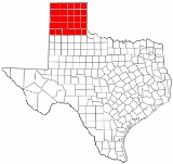
The Texas Panhandle is a region of the U.S. state
of Texas
consisting of the northernmost 26 counties in the state. The panhandle
is a rectangular area bordered by New Mexico
to the west and Oklahoma
to the north and east. The Handbook of Texas defines the southern border of Swisher County
to be the southern boundary of the Texas Panhandle region, though some consider the region to extend as far south as Lubbock County., The Texas Panhandle Press Association accepts members in the actual panhandle and a triangle formed by its southern tier, the southeastern border of New Mexico and a diagonal to the beginning, which includes Lubbock County.
Its land area is 66,883.58 km² (25,823.9 sq mi), or nearly 10 percent of the state's total. There is an additional 162.53 km² (62.75 sq mi) of water area. Its population as of the 2010 census
was 427,927 residents, or 1.7 percent of the state's total population. As of the 2010 census, this would put the average population density for the region at 16.6 persons/sq mi. The Panhandle
is distinct from North Texas
, which is more to the southeast.
West of the Caprock Escarpment
and north and south of the Canadian River
breaks, the surface of the Llano Estacado
is rather flat. South of the city of Amarillo
, the level terrain gives way to Palo Duro Canyon
, the second largest canyon in the United States
. This colorful canyon was carved by the Prairie Dog Town Fork Red River
. North of Amarillo lies Lake Meredith
, a reservoir created by Sanford Dam on the Canadian River
. The lake, along with the Ogallala Aquifer
, provide drinking water and irrigation for this moderately dry area of the high plains
.
Interstate Highway 40 passes through
the panhandle, and also passes through Amarillo
. The highway passes through Deaf Smith, Oldham, Potter, Carson
, Gray, Donley
, and Wheeler Counties.
Because the Act of Admission of Texas
into the Union allows the state to divide itself, a bill was introduced to the Texas legislature in 1915 in order to create a State of Jefferson
, made up of the Texas Panhandle.
The Texas Panhandle has been identified as one of the fastest-growing wind-power-producing regions in the nation over the past decade because of its strong, steady winds.
, 23.8% were Hispanic
, and 4.6% were African American
. Only 2.7% were of some other ethnicity. 92.3% of inhabitants claimed native birth, and 8.9% were veterans
of the United States armed forces
. 49.9% of the population was male
, and 50.1% was female
. 13.2% of the population were 65 years of age or older
, whereas 27.8% of the population was under 18 years of age
.
Some of the smaller towns with populations less than 10,000 include:
, the region is very politically and socially conservative. It was one of the first regions of the state to break away from its Democratic
roots, though Democrats continued to do well at the local level well into the 1980s. However, Republicans
now dominate every level of government, holding nearly every elected post above the county level.
In the 2008 Presidential Election
, John McCain
received 78.82% of the vote, as compared with Barack Obama
's 20.48% share of the vote. Other candidates received 0.70% of the total vote. However, most (62.2%) of Barack Obama
's votes came from Potter and Randall Counties, near Amarillo, the only large city in the region, with the rest of the panhandle being even more strongly conservative. In Ochiltree County, John McCain
received 91.97% of the vote.
Nearly all of the Panhandle is in , represented by Republican Mac Thornberry
. With a Cook Partisan Voting Index
of R+29, it is tied for the most Republican district in the nation. The counties of Castro, Deaf Smith, and Parmer are in the , represented by Republican Randy Neugebauer
.
U.S. state
A U.S. state is any one of the 50 federated states of the United States of America that share sovereignty with the federal government. Because of this shared sovereignty, an American is a citizen both of the federal entity and of his or her state of domicile. Four states use the official title of...
of Texas
Texas
Texas is the second largest U.S. state by both area and population, and the largest state by area in the contiguous United States.The name, based on the Caddo word "Tejas" meaning "friends" or "allies", was applied by the Spanish to the Caddo themselves and to the region of their settlement in...
consisting of the northernmost 26 counties in the state. The panhandle
Panhandle
A panhandle is an informal geographic term for an elongated arm-like protrusion of a geo-political entity, such as a subnational entity or a sovereign state.-Term:...
is a rectangular area bordered by New Mexico
New Mexico
New Mexico is a state located in the southwest and western regions of the United States. New Mexico is also usually considered one of the Mountain States. With a population density of 16 per square mile, New Mexico is the sixth-most sparsely inhabited U.S...
to the west and Oklahoma
Oklahoma
Oklahoma is a state located in the South Central region of the United States of America. With an estimated 3,751,351 residents as of the 2010 census and a land area of 68,667 square miles , Oklahoma is the 28th most populous and 20th-largest state...
to the north and east. The Handbook of Texas defines the southern border of Swisher County
Swisher County, Texas
Swisher County is a county located in the U.S. state of Texas. In 2000, its population was 8,378. Its seat is Tulia. The county is named for James G. Swisher, a soldier of the Texas Revolution and signer of the Texas Declaration of Independence...
to be the southern boundary of the Texas Panhandle region, though some consider the region to extend as far south as Lubbock County., The Texas Panhandle Press Association accepts members in the actual panhandle and a triangle formed by its southern tier, the southeastern border of New Mexico and a diagonal to the beginning, which includes Lubbock County.
Its land area is 66,883.58 km² (25,823.9 sq mi), or nearly 10 percent of the state's total. There is an additional 162.53 km² (62.75 sq mi) of water area. Its population as of the 2010 census
United States Census, 2010
The Twenty-third United States Census, known as Census 2010 or the 2010 Census, is the current national census of the United States. National Census Day was April 1, 2010 and is the reference date used in enumerating individuals...
was 427,927 residents, or 1.7 percent of the state's total population. As of the 2010 census, this would put the average population density for the region at 16.6 persons/sq mi. The Panhandle
Panhandle
A panhandle is an informal geographic term for an elongated arm-like protrusion of a geo-political entity, such as a subnational entity or a sovereign state.-Term:...
is distinct from North Texas
North Texas
North Texas is a distinct cultural and geographic area forming the central-northeastern section of the U.S. state of Texas. North Texas is generally considered to include the area south of Oklahoma, east of Abilene, and north of Waco...
, which is more to the southeast.
West of the Caprock Escarpment
Caprock Escarpment
The Caprock Escarpment is a term used in Texas and Eastern New Mexico to describe the geographical transition point between the level elevated plains of the Llano Estacado and the surrounding rolling terrain. In Texas, the escarpment stretches around 320 km south-southwest from the northeast...
and north and south of the Canadian River
Canadian River
The Canadian River is the longest tributary of the Arkansas River. It is about long, starting in Colorado and traveling through New Mexico, the Texas Panhandle, and most of Oklahoma....
breaks, the surface of the Llano Estacado
Llano Estacado
Llano Estacado , commonly known as the Staked Plains, is a region in the Southwestern United States that encompasses parts of eastern New Mexico and northwestern Texas, including the South Plains and parts of the Texas Panhandle...
is rather flat. South of the city of Amarillo
Amarillo, Texas
Amarillo is the 14th-largest city, by population, in the state of Texas, the largest in the Texas Panhandle, and the seat of Potter County. A portion of the city extends into Randall County. The population was 190,695 at the 2010 census...
, the level terrain gives way to Palo Duro Canyon
Palo Duro Canyon
Palo Duro Canyon is a canyon system of the Caprock Escarpment located in the Texas Panhandle near the city of Amarillo, Texas, United States. As the second largest canyon in the United States, it is roughly long and has an average width of , but reaches a width of at places. Its depth is around...
, the second largest canyon in the United States
United States
The United States of America is a federal constitutional republic comprising fifty states and a federal district...
. This colorful canyon was carved by the Prairie Dog Town Fork Red River
Prairie Dog Town Fork Red River
Prairie Dog Town Fork Red River is a sandy-braided stream about long, formed at the confluence of Palo Duro Creek and Tierra Blanca Creek, about northeast of Canyon in Randall County, Texas, and flowing east-southeastward to the Red River about east of the 100th meridian, south-southwest of...
. North of Amarillo lies Lake Meredith
Lake Meredith
Lake Meredith is a reservoir formed by Sanford Dam on the Canadian River at Sanford, Texas. It is located about northeast of Amarillo, Texas in the Texas Panhandle. It is a major source of drinking water for Amarillo and Lubbock, Texas, located about to the south along with many other towns in...
, a reservoir created by Sanford Dam on the Canadian River
Canadian River
The Canadian River is the longest tributary of the Arkansas River. It is about long, starting in Colorado and traveling through New Mexico, the Texas Panhandle, and most of Oklahoma....
. The lake, along with the Ogallala Aquifer
Ogallala Aquifer
The Ogallala Aquifer, also known as the High Plains Aquifer, is a vast yet shallow underground water table aquifer located beneath the Great Plains in the United States...
, provide drinking water and irrigation for this moderately dry area of the high plains
High Plains (United States)
The High Plains are a subregion of the Great Plains mostly in the Western United States, but also partly in the Midwest states of Nebraska, Kansas, and South Dakota, generally encompassing the western part of the Great Plains before the region reaches the Rocky Mountains...
.
Interstate Highway 40 passes through
Interstate 40 in Texas
In the U.S. state of Texas, Interstate 40 runs east–west through the panhandle in the northwest part of the state. The only large city it passes through is Amarillo, where it meets the north end of Interstate 27.-History:...
the panhandle, and also passes through Amarillo
Amarillo, Texas
Amarillo is the 14th-largest city, by population, in the state of Texas, the largest in the Texas Panhandle, and the seat of Potter County. A portion of the city extends into Randall County. The population was 190,695 at the 2010 census...
. The highway passes through Deaf Smith, Oldham, Potter, Carson
Carson County, Texas
Carson County is a county located in the U.S. state of Texas. It is part of the Amarillo metropolitan area. In 2000, its population was 6,516. Carson is named for Samuel Price Carson, the first secretary of state of the Republic of Texas. The seat of the county is Panhandle. It was founded in...
, Gray, Donley
Donley County, Texas
Donley County is a county located in the U.S. state of Texas. In 2000, its population was 3,828. It is named for Stockton P. Donley, a frontier lawyer. Its county seat is Clarendon....
, and Wheeler Counties.
Because the Act of Admission of Texas
Texas
Texas is the second largest U.S. state by both area and population, and the largest state by area in the contiguous United States.The name, based on the Caddo word "Tejas" meaning "friends" or "allies", was applied by the Spanish to the Caddo themselves and to the region of their settlement in...
into the Union allows the state to divide itself, a bill was introduced to the Texas legislature in 1915 in order to create a State of Jefferson
Jefferson (South state)
The name State of Jefferson was a name proposed for a new state in two plans for the division of the State of Texas.-Background:In the bill that annexed the Republic of Texas to the United States, allows the State to divided itself into additional states up to four...
, made up of the Texas Panhandle.
The Texas Panhandle has been identified as one of the fastest-growing wind-power-producing regions in the nation over the past decade because of its strong, steady winds.
Demographics of the Panhandle
As of the census of 2000, approximately 402,862 people lived in the panhandle. Of these, 68.9% were non-Hispanic WhiteWhite American
White Americans are people of the United States who are considered or consider themselves White. The United States Census Bureau defines White people as those "having origins in any of the original peoples of Europe, the Middle East, or North Africa...
, 23.8% were Hispanic
Hispanic and Latino Americans
Hispanic or Latino Americans are Americans with origins in the Hispanic countries of Latin America or in Spain, and in general all persons in the United States who self-identify as Hispanic or Latino.1990 Census of Population and Housing: A self-designated classification for people whose origins...
, and 4.6% were African American
African American
African Americans are citizens or residents of the United States who have at least partial ancestry from any of the native populations of Sub-Saharan Africa and are the direct descendants of enslaved Africans within the boundaries of the present United States...
. Only 2.7% were of some other ethnicity. 92.3% of inhabitants claimed native birth, and 8.9% were veterans
Veteran
A veteran is a person who has had long service or experience in a particular occupation or field; " A veteran of ..."...
of the United States armed forces
United States armed forces
The United States Armed Forces are the military forces of the United States. They consist of the Army, Navy, Marine Corps, Air Force, and Coast Guard.The United States has a strong tradition of civilian control of the military...
. 49.9% of the population was male
Man
The term man is used for an adult human male . However, man is sometimes used to refer to humanity as a whole...
, and 50.1% was female
Woman
A woman , pl: women is a female human. The term woman is usually reserved for an adult, with the term girl being the usual term for a female child or adolescent...
. 13.2% of the population were 65 years of age or older
Senior citizen
Senior citizen is a common polite designation for an elderly person in both UK and US English, and it implies or means that the person is retired. This in turn implies or in fact means that the person is over the retirement age, which varies according to country. Synonyms include pensioner in UK...
, whereas 27.8% of the population was under 18 years of age
Minor (law)
In law, a minor is a person under a certain age — the age of majority — which legally demarcates childhood from adulthood; the age depends upon jurisdiction and application, but is typically 18...
.
Counties
The 26 northernmost counties that make up the Texas Panhandle include:- Armstrong CountyArmstrong County, TexasArmstrong County is a county located in the U.S. state of Texas, and was formed in 1876 from Bexar County. It is part of the Amarillo metropolitan area. As of 2000, the population is 2,148. Its county seat is Claude. Armstrong is named for one of several Texas pioneer families named Armstrong...
- Briscoe County
- Carson CountyCarson County, TexasCarson County is a county located in the U.S. state of Texas. It is part of the Amarillo metropolitan area. In 2000, its population was 6,516. Carson is named for Samuel Price Carson, the first secretary of state of the Republic of Texas. The seat of the county is Panhandle. It was founded in...
- Castro County
- Childress County
- Collingsworth County
- Dallam County
- Deaf Smith County
- Donley CountyDonley County, TexasDonley County is a county located in the U.S. state of Texas. In 2000, its population was 3,828. It is named for Stockton P. Donley, a frontier lawyer. Its county seat is Clarendon....
- Gray County
- Hall County
- Hansford CountyHansford County, TexasHansford County is a county located in the U.S. state of Texas. In 2010, its population was 5,613. The county is named for John M. Hansford, a Texas state congressman and judge. Hansford County is one of 30 prohibition, or entirely dry, counties in the state of Texas. Its seat is...
- Hartley County
- Hemphill County
- Hutchinson CountyHutchinson County, TexasHutchinson County is a county located in the U.S. state of Texas in the northern portion of the Texas Panhandle. In 2000, its population was 23,857. Its seat is Stinnett . Hutchinson County is named for Andrew Hutchinson, an early Texas attorney....
- Lipscomb County
- Moore County
- Ochiltree County
- Oldham County
- Parmer County
- Potter County
- Randall County
- Roberts County
- Sherman County
- Swisher CountySwisher County, TexasSwisher County is a county located in the U.S. state of Texas. In 2000, its population was 8,378. Its seat is Tulia. The county is named for James G. Swisher, a soldier of the Texas Revolution and signer of the Texas Declaration of Independence...
- Wheeler County
Cities and Towns
Major cities of the Texas Panhandle with populations greater than 10,000 include:- AmarilloAmarillo, TexasAmarillo is the 14th-largest city, by population, in the state of Texas, the largest in the Texas Panhandle, and the seat of Potter County. A portion of the city extends into Randall County. The population was 190,695 at the 2010 census...
- BorgerBorger, TexasBorger is the largest city in Hutchinson County, Texas, United States. The population was 14,302 at the 2000 census. Borger is named for businessman Asa Philip "Ace" Borger, who also established the Hutchinson County seat of Stinnett and several other small towns in Texas and Oklahoma.- History...
- CanyonCanyon, TexasCanyon is a city in Randall County, Texas, United States. The population was 12,875 at the 2000 census. It is the county seat of Randall County. It is the home of West Texas A&M University and Panhandle-Plains Historical Museum. Palo Duro Canyon State Park is some twelve miles east of Canyon...
- DumasDumas, TexasDumas is a city in Moore County, Texas, United States. The population was 13,747 at the 2000 census. It is the county seat of Moore County. Located approximately fifty miles north of Amarillo, the city is named for...
- HerefordHereford, TexasHereford is a city in Deaf Smith County, Texas, United States. The population was 14,597 at the 2000 census. It is the only incorporated Hereford in the country. It is the county seat of Deaf Smith County....
- PampaPampa, TexasPampa is a city in Gray County, Texas, United States. The population was 17,887 at the 2000 census. It is the county seat of Gray County.Pampa is the principal city of the Pampa Micropolitan Statistical Area, which includes all of Gray and Roberts counties....
Some of the smaller towns with populations less than 10,000 include:
- BookerBooker, TexasBooker is a town in Lipscomb and Ochiltree Counties in the U.S. state of Texas and named for B.F. Booker, a civil engineer for the Panhandle and Santa Fe Railway. The population was 1,315 at the 2000 census.-Geography:...
- BovinaBovina, TexasBovina is a city in Parmer County, Texas, United States. The population was 1,874 at the 2000 census.One of the best-known Bovina residents was John Elmo Sherrill, Jr. , who held four different public offices in Bovina and Parmer County, including Bovina alderman, mayor , school board member, and...
- CactusCactus, TexasCactus is a city in Moore County, Texas, United States, along U.S. Route 287. The population was 2,538 at the 2000 census."Cactus Texas", a song by Waylon Jennings, is a sketch of Cactus in more innocent days .-Geography:...
- CanadianCanadian, TexasCanadian is the county seat of Hemphill County, Texas, United States. The population was 2,233 at the 2000 census. It is named for the Canadian River, a tributary of the nearby Arkansas River. Canadian is sometimes called "the oasis of the Texas Panhandle."-History:The trails along the river are...
- ChildressChildress, TexasChildress is a city in Childress County, Texas, United States. The population was 6,778 at the 2000 census. It is the county seat of Childress County. Like the county, the city is named for George Campbell Childress, a native of Nashville, Tennessee, who was the principal author of the Texas...
- ClarendonClarendon, TexasClarendon is a city in Donley County, Texas, United States. The population was 1,974 at the 2000 census. The county seat of Donley County, Clarendon is located on United States Highway 287 in the Texas Panhandle some sixty miles east of Amarillo. It was established in 1878 by Methodist clergyman L.H...
- ClaudeClaude, TexasClaude is a city in Armstrong County, Texas, United States. The population was 1,313 at the 2000 census. Located east of Amarillo, Claude is the county seat of Armstrong County in the south Texas Panhandle...
- DalhartDalhart, TexasDalhart is a city in Dallam and Hartley counties in the U.S. state of Texas, and the county seat of Dallam County. The population was 7,237 at the 2000 census. Founded in 1901, Dalhart is named for its location on the border of Dallam and Hartley counties. Dalhart sits at the intersection of U.S....
- DimmittDimmitt, TexasDimmitt is a city in Castro County, Texas, United States. The population was 4,375 at the 2000 census. It is the county seat of Castro County. It is located on the old Ozark Trail, a road system from St. Louis, Missouri, to El Paso, Texas...
- FrionaFriona, TexasFriona is a city in Parmer County, Texas, United States. The population was 3,854 at the 2000 census. Friona was established in 1906, originally called Frio the Spanishword for cold....
- FritchFritch, TexasFritch is a city in Hutchinson and Moore counties in the U.S. state of Texas. The population was 2,235 at the 2000 census. Fritch and the surrounding area is served by ZIP code 79036...
- MemphisMemphis, TexasMemphis is a city in Hall County, Texas, in the United States. As of the 2000 census, the population was 2,479. It is the county seat of Hall County.Memphis is the birthplace of former U.S...
- PanhandlePanhandle, TexasPanhandle is a town in Carson County, Texas, United States. The population was 2,589 at the 2000 census. It is the county seat of Carson County. Panhandle is part of the Amarillo, Texas Metropolitan Statistical Area...
- PerrytonPerryton, TexasPerryton is a city in Ochiltree County, Texas, United States. The population was 7,774 at the 2000 census. It is the county seat of Ochiltree County.-Geography:Perryton is located at ....
- ShamrockShamrock, Texas-Demographics:As of the census of 2000, there were 2,029 people, 852 households, and 550 families residing in the city. The population density was 979.7 people per square mile . There were 1,072 housing units at an average density of 517.6 per square mile...
- SpearmanSpearman, TexasSpearman is a city in Hansford County, Texas, in the United States. As of the 2010 census, the city population was 3,368. It is the county seat of Hansford County, and is known for its collection of windmills from the J.B. Buchanan windmill collection. The city was named for Thomas E...
- StinnettStinnett, TexasStinnett is a small city in Hutchinson County, Texas, in the United States. As of the 2000 census, the city population was 1,936. Located in the northern Texas Panhandle, Stinnett is the county seat of Hutchinson County.-History:...
- StratfordStratford, TexasStratford is a city in Sherman County, Texas, United States. The population was 1,991 at the 2000 census. It is the county seat of Sherman County...
- SunraySunray, TexasSunray is a city in Moore County, Texas, United States. The population was 1,950 at the 2000 census.- History :Sunray, Texas was founded by Jack Clarence Collins. He was born in Hartley, Texas in 1893, and in 1902 moved to Channing, Texas with his parents, Mr. and Mrs. E.S. Collins...
- TuliaTulia, TexasTulia is a city in, and county seat of, Swisher County, Texas, United States. The population was 5,117 at the 2000 census; in the 2005 census estimate, it had fallen to 4,714. The city is at the junction of U.S. Route 87 and Texas State Highway 86, approximately two miles east Interstate 27...
- WellingtonWellington, TexasWellington is a city in Collingsworth County, Texas, United States. The population was 2,275 at the 2000 census. It is the county seat of Collingsworth County.-Geography:Wellington is located at ....
Politics
Much like the Oklahoma PanhandleOklahoma Panhandle
The Oklahoma Panhandle is the extreme western region of the state of Oklahoma, comprising Cimarron County, Texas County, and Beaver County. Its name comes from the similarity of shape to the handle of a cooking pan....
, the region is very politically and socially conservative. It was one of the first regions of the state to break away from its Democratic
Democratic Party (United States)
The Democratic Party is one of two major contemporary political parties in the United States, along with the Republican Party. The party's socially liberal and progressive platform is largely considered center-left in the U.S. political spectrum. The party has the lengthiest record of continuous...
roots, though Democrats continued to do well at the local level well into the 1980s. However, Republicans
Republican Party (United States)
The Republican Party is one of the two major contemporary political parties in the United States, along with the Democratic Party. Founded by anti-slavery expansion activists in 1854, it is often called the GOP . The party's platform generally reflects American conservatism in the U.S...
now dominate every level of government, holding nearly every elected post above the county level.
In the 2008 Presidential Election
United States presidential election, 2008
The United States presidential election of 2008 was the 56th quadrennial presidential election. It was held on November 4, 2008. Democrat Barack Obama, then the junior United States Senator from Illinois, defeated Republican John McCain, the senior U.S. Senator from Arizona. Obama received 365...
, John McCain
John McCain
John Sidney McCain III is the senior United States Senator from Arizona. He was the Republican nominee for president in the 2008 United States election....
received 78.82% of the vote, as compared with Barack Obama
Barack Obama
Barack Hussein Obama II is the 44th and current President of the United States. He is the first African American to hold the office. Obama previously served as a United States Senator from Illinois, from January 2005 until he resigned following his victory in the 2008 presidential election.Born in...
's 20.48% share of the vote. Other candidates received 0.70% of the total vote. However, most (62.2%) of Barack Obama
Barack Obama
Barack Hussein Obama II is the 44th and current President of the United States. He is the first African American to hold the office. Obama previously served as a United States Senator from Illinois, from January 2005 until he resigned following his victory in the 2008 presidential election.Born in...
's votes came from Potter and Randall Counties, near Amarillo, the only large city in the region, with the rest of the panhandle being even more strongly conservative. In Ochiltree County, John McCain
John McCain
John Sidney McCain III is the senior United States Senator from Arizona. He was the Republican nominee for president in the 2008 United States election....
received 91.97% of the vote.
Nearly all of the Panhandle is in , represented by Republican Mac Thornberry
Mac Thornberry
William McClellan "Mac" Thornberry is the U.S. Representative for , serving since 1995. He is a member of the Republican Party....
. With a Cook Partisan Voting Index
Cook Partisan Voting Index
The Cook Partisan Voting Index , sometimes referred to as simply the Partisan Voting Index , is a measurement of how strongly an American congressional district or state leans toward one political party compared to the nation as a whole...
of R+29, it is tied for the most Republican district in the nation. The counties of Castro, Deaf Smith, and Parmer are in the , represented by Republican Randy Neugebauer
Randy Neugebauer
Robert Randolph "Randy" Neugebauer is the U.S. Representative for , serving since a special election in 2003. He is a member of the Republican Party. The district includes a large swath of West Texas, including Lubbock and Abilene...
.
See also
- Buffalo Lake National Wildlife RefugeBuffalo Lake National Wildlife RefugeNot to be confused with Buffalo Lake National Wildlife Refuge Once buffalo grazed the shortgrass prairie seen today at Buffalo Lake National Wildlife Refuge in Randall County of the Texas Panhandle. Once a lake reflected the clouds. The buffalo vanished. The lake has dried...
- Caprock EscarpmentCaprock EscarpmentThe Caprock Escarpment is a term used in Texas and Eastern New Mexico to describe the geographical transition point between the level elevated plains of the Llano Estacado and the surrounding rolling terrain. In Texas, the escarpment stretches around 320 km south-southwest from the northeast...
- List of geographical regions in Texas
- List of airports in the Texas Panhandle
- Llano EstacadoLlano EstacadoLlano Estacado , commonly known as the Staked Plains, is a region in the Southwestern United States that encompasses parts of eastern New Mexico and northwestern Texas, including the South Plains and parts of the Texas Panhandle...
- Oklahoma PanhandleOklahoma PanhandleThe Oklahoma Panhandle is the extreme western region of the state of Oklahoma, comprising Cimarron County, Texas County, and Beaver County. Its name comes from the similarity of shape to the handle of a cooking pan....
- Palo Duro CanyonPalo Duro CanyonPalo Duro Canyon is a canyon system of the Caprock Escarpment located in the Texas Panhandle near the city of Amarillo, Texas, United States. As the second largest canyon in the United States, it is roughly long and has an average width of , but reaches a width of at places. Its depth is around...
- Prairie Dog Town Fork Red RiverPrairie Dog Town Fork Red RiverPrairie Dog Town Fork Red River is a sandy-braided stream about long, formed at the confluence of Palo Duro Creek and Tierra Blanca Creek, about northeast of Canyon in Randall County, Texas, and flowing east-southeastward to the Red River about east of the 100th meridian, south-southwest of...
- Texas State Highway 207Texas State Highway 207State Highway 207 or SH 207 is a state Highway that runs from the Texas/Oklahoma state line south through the Texas Panhandle, ending in Post. The highway was originally designated between 1933 and 1936 between Floydada and Ralls. By 1939, the designation was extended north to Silverton and south...
- West TexasWest TexasWest Texas is a vernacular term applied to a region in the southwestern quadrant of the United States that primarily encompasses the arid and semi-arid lands in the western portion of the state of Texas....