
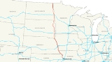
Interstate 29
Encyclopedia
Interstate 29 is an Interstate Highway in the Midwestern United States
. I-29 runs from Kansas City, Missouri
, at a junction with Interstate 35
and Interstate 70
to the Canadian border near Pembina, North Dakota
, where it connects with Manitoba Highway 75 via the short Manitoba Highway 29.
|MO
|123
|198
|-
|IA
|161
|259
|-
|SD
|252
|406
|-
|ND
|217
|349
|-
|Total
|753
|1,212
|}
. The interstate diverts from U.S. 71
just north of St. Joseph and follows a sparsely populated corridor along the Missouri River
to Council Bluffs. During the design phase there was an alternative sending the route further along U.S. 71
through the bigger towns of Maryville, Missouri
and Clarinda, Iowa
. During the Great Flood of 1993
the Missouri River flooded this section and traffic was rerouted to U.S. 71
through Maryville and Clarinda.
Almost all of I-29 in Missouri is in an area called the Platte Purchase
that was not originally part of Missouri when it entered the union.
. It goes northwest to an interchange with Iowa Highway 2, then goes north until Council Bluffs
. In Council Bluffs, it runs concurrent with Interstate 80
. It winds its way along the western and northern edges of Council Bluffs after separating from I-80. North of Council Bluffs, I-29 runs concurrent with Interstate 680 between Exits 61 and 71. After Interstate 680 separates, I-29 continues on a northwesterly path toward Sioux City
. At Sioux City, Interstate 129
spurs off of I-29 to go west toward South Sioux City, Nebraska
. After continuing toward downtown Sioux City on a northerly route, I-29 turns west and enters South Dakota.
by crossing over the Big Sioux River
. It runs northwest until its interchange with South Dakota Highway 50
near Vermillion
, where it turns north. The highway alignment is due north until just before Sioux Falls
. In the Sioux Falls area, I-29 serves the western part of Sioux Falls while I-229
spurs off and serves eastern Sioux Falls. In northwestern Sioux Falls, I-29 meets Interstate 90
. After that, it continues north past Brookings
and an intersection with US 14
. At the intersection with South Dakota Highway 28
, I-29 turns northwest toward Watertown
. After Watertown, the highway continues north and passes an intersection with US 12
before continuing into North Dakota
.
. At Fargo, it meets Interstate 94
and continues north along the Red River
toward Grand Forks
. At its northern terminus, I-29 enters Canada
and becomes Manitoba
Provincial Trunk Highway 29, a very short (0.3 miles) connector road to Provincial Trunk Highway 75, which leads to Winnipeg.
to the Canadian border was originally considered for designation as Interstate 31 in 1957 for present-day I-29. No freeway was initially planned south of Fargo. However, it was subsequently decided in 1958 to connect I-29 and I-31 between Sioux Falls and Fargo. The entire freeway was then built and numbered as I-29.
United States
The United States of America is a federal constitutional republic comprising fifty states and a federal district...
. I-29 runs from Kansas City, Missouri
Kansas City, Missouri
Kansas City, Missouri is the largest city in the U.S. state of Missouri and is the anchor city of the Kansas City Metropolitan Area, the second largest metropolitan area in Missouri. It encompasses in parts of Jackson, Clay, Cass, and Platte counties...
, at a junction with Interstate 35
Interstate 35
Interstate 35 is a north–south Interstate Highway in the central United States. I-35 stretches from Laredo, Texas, on the U.S.-Mexico border to Duluth, Minnesota, at Minnesota Highway 61 and 26th Avenue East. Many interstates used to have splits or spurs indicated with suffixed letters , but I-35...
and Interstate 70
Interstate 70
Interstate 70 is an Interstate Highway in the United States that runs from Interstate 15 near Cove Fort, Utah, to a Park and Ride near Baltimore, Maryland. It was the first Interstate Highway project in the United States. I-70 approximately traces the path of U.S. Route 40 east of the Rocky...
to the Canadian border near Pembina, North Dakota
Pembina, North Dakota
Pembina is a city in Pembina County, North Dakota in the United States. The population was 592 at the 2010 census.The area of Pembina was long inhabited by various indigenous peoples...
, where it connects with Manitoba Highway 75 via the short Manitoba Highway 29.
Route description
|-|MO
Interstate 29 in Missouri
Interstate 29, a major north–south Interstate Highway in the Midwestern United States, begins in Missouri. It travels through the Kansas City and St. Joseph metropolitan areas before exiting the state and entering Iowa...
|123
|198
|-
|IA
Interstate 29 in Iowa
In the U.S. state of Iowa, Interstate 29 is a north–south Interstate Highway which closely parallels the Missouri River. I-29 enters Iowa from Missouri near Hamburg and heads to the north-northwest through the Omaha-Council Bluffs and the Sioux City areas. It exits the state by crossing...
|161
|259
|-
|SD
Interstate 29 in South Dakota
In the U.S. state of South Dakota, Interstate 29 traverses on the eastern side of the state, bypassing through Sioux Falls, the state's largest city.-Route description:...
|252
|406
|-
|ND
|217
|349
|-
|Total
|753
|1,212
|}
Missouri
Near its southern terminus, I-29 is concurrent with I-35 and U.S. Route 71U.S. Route 71
U.S. Route 71 is a north–south United States highway. This original 1926 route has remained largely unchanged by encroaching Interstate highways. Currently, the highway's northern terminus is in International Falls, Minnesota at the Canadian border, at the southern end of the Fort...
. The interstate diverts from U.S. 71
U.S. Route 71
U.S. Route 71 is a north–south United States highway. This original 1926 route has remained largely unchanged by encroaching Interstate highways. Currently, the highway's northern terminus is in International Falls, Minnesota at the Canadian border, at the southern end of the Fort...
just north of St. Joseph and follows a sparsely populated corridor along the Missouri River
Missouri River
The Missouri River flows through the central United States, and is a tributary of the Mississippi River. It is the longest river in North America and drains the third largest area, though only the thirteenth largest by discharge. The Missouri's watershed encompasses most of the American Great...
to Council Bluffs. During the design phase there was an alternative sending the route further along U.S. 71
U.S. Route 71
U.S. Route 71 is a north–south United States highway. This original 1926 route has remained largely unchanged by encroaching Interstate highways. Currently, the highway's northern terminus is in International Falls, Minnesota at the Canadian border, at the southern end of the Fort...
through the bigger towns of Maryville, Missouri
Maryville, Missouri
Maryville is a city in Nodaway County, Missouri, United States. The population was 10,581 at the 2000 census. The town, organized on February 14, 1845, was named for Mrs. Mary Graham, wife of Amos Graham, then the county clerk. Mary was the first Caucasian woman to have lived within the boundaries...
and Clarinda, Iowa
Clarinda, Iowa
-2010 census:The 2010 census recorded a population of 5,572 in the city, with a population density of . There were 2,180 housing units, of which 1,928 were occupied....
. During the Great Flood of 1993
Great Flood of 1993
The Great Mississippi and Missouri Rivers Flood of 1993 occurred in the American Midwest, along the Mississippi and Missouri rivers and their tributaries, from April to October 1993. The flood was among the most costly and devastating to ever occur in the United States, with $15 billion in damages...
the Missouri River flooded this section and traffic was rerouted to U.S. 71
U.S. Route 71
U.S. Route 71 is a north–south United States highway. This original 1926 route has remained largely unchanged by encroaching Interstate highways. Currently, the highway's northern terminus is in International Falls, Minnesota at the Canadian border, at the southern end of the Fort...
through Maryville and Clarinda.
Almost all of I-29 in Missouri is in an area called the Platte Purchase
Platte Purchase
The Platte Purchase was a land acquisition in 1836 by the United States government from Native American tribes all of which was east bank lands along the Missouri River that added to the northwest corner of the state of Missouri. The area acquired is almost as large as the states of Delaware and...
that was not originally part of Missouri when it entered the union.
Iowa
Interstate 29 begins in Iowa near HamburgHamburg, Iowa
Hamburg is a city in Fremont County, Iowa, United States, along the Nishnabotna River. The population was 1,240 at the 2000 census.-Geography:According to the United States Census Bureau, the city has a total area of , all of it land.-Demographics:...
. It goes northwest to an interchange with Iowa Highway 2, then goes north until Council Bluffs
Council Bluffs, Iowa
Council Bluffs, known until 1852 as Kanesville, Iowathe historic starting point of the Mormon Trail and eventual northernmost anchor town of the other emigrant trailsis a city in and the county seat of Pottawattamie County, Iowa, United States and is on the east bank of the Missouri River across...
. In Council Bluffs, it runs concurrent with Interstate 80
Interstate 80
Interstate 80 is the second-longest Interstate Highway in the United States, following Interstate 90. It is a transcontinental artery running from downtown San Francisco, California to Teaneck, New Jersey in the New York City Metropolitan Area...
. It winds its way along the western and northern edges of Council Bluffs after separating from I-80. North of Council Bluffs, I-29 runs concurrent with Interstate 680 between Exits 61 and 71. After Interstate 680 separates, I-29 continues on a northwesterly path toward Sioux City
Sioux City, Iowa
Sioux City is a city in Plymouth and Woodbury counties in the western part of the U.S. state of Iowa. The population was 82,684 in the 2010 census, a decline from 85,013 in the 2000 census, which makes it currently the fourth largest city in the state....
. At Sioux City, Interstate 129
Interstate 129
Interstate 129 is an auxiliary Interstate Highway which connects South Sioux City to Interstate 29 in Sioux City, Iowa. Opened in 1976, I-129 is a long route, running in Nebraska. At , Interstate 129 is the shortest highway in the state of Iowa...
spurs off of I-29 to go west toward South Sioux City, Nebraska
South Sioux City, Nebraska
-2000 Census:As of the census of 2000, there were 11,925 people, 4,304 households, and 2,961 families residing in the city. Of the 11,925 people, 48.6% are male and 51.4% are female. The population density was 2,431.6 people per square mile . There were 4,557 housing units at an average density of...
. After continuing toward downtown Sioux City on a northerly route, I-29 turns west and enters South Dakota.
South Dakota
Interstate 29 enters South Dakota at North Sioux CityNorth Sioux City, South Dakota
As of the census of 2000, there were 2,288 people, 916 households, and 621 families residing in the city. The population density was 1,021.7 people per square mile . There were 953 housing units at an average density of 425.6 per square mile...
by crossing over the Big Sioux River
Big Sioux River
The Big Sioux River is a tributary of the Missouri River, long, in eastern South Dakota and northwestern Iowa in the United States. The United States Board on Geographic Names settled on "Big Sioux River" as the stream's name in 1961....
. It runs northwest until its interchange with South Dakota Highway 50
South Dakota Highway 50
South Dakota Highway 50 is a state route serving south central and southeast South Dakota. The current alignment begins at the junction of South Dakota Highway 34 at "Lee's Corner" east of Fort Thompson, and ends at the Iowa border near Richland, where it continues as Iowa Highway 3...
near Vermillion
Vermillion, South Dakota
Vermillion is a city in and the county seat of Clay County, in the southeastern corner of the U.S. state of South Dakota, and the tenth largest city in the state. According to the 2010 Census, the population was 10,571. Vermillion lies atop a bluff near the Missouri River.The area has been home to...
, where it turns north. The highway alignment is due north until just before Sioux Falls
Sioux Falls, South Dakota
Sioux Falls is the largest city in the U.S. state of South Dakota. Sioux Falls is the county seat of Minnehaha County, and also extends into Lincoln County to the south...
. In the Sioux Falls area, I-29 serves the western part of Sioux Falls while I-229
Interstate 229 (South Dakota)
Interstate 229 in South Dakota runs just more than ten miles mostly within the city limits of Sioux Falls, the largest city in the state. It runs from Interstate 29 to Interstate 90...
spurs off and serves eastern Sioux Falls. In northwestern Sioux Falls, I-29 meets Interstate 90
Interstate 90
Interstate 90 is the longest Interstate Highway in the United States at . It is the northernmost coast-to-coast interstate, and parallels US 20 for the most part. Its western terminus is in Seattle, at Edgar Martinez Drive S. near Safeco Field and CenturyLink Field, and its eastern terminus is in...
. After that, it continues north past Brookings
Brookings, South Dakota
Brookings is a city in Brookings County, South Dakota, United States. Brookings is the fourth largest city in South Dakota, with a population of 22,056 at the 2010 census. It is the county seat of Brookings County, and home to South Dakota State University, the largest institution of higher...
and an intersection with US 14
U.S. Route 14
U.S. Route 14 , an east–west route, is one of the original United States highways of 1926. It currently has a length of 1,398 miles , but it had a peak length of 1,429 miles . For much of its length, it runs roughly parallel to Interstate 90.As of 2004, the highway's eastern terminus is in...
. At the intersection with South Dakota Highway 28
South Dakota Highway 28
South Dakota Highway 28 is a state route located in east central South Dakota. It begins at U.S. Highway 281 west of Hitchcock, and runs easterly to the Minnesota border east of Astoria, becoming Minnesota State Highway 271. It is 109 miles in length.-History:South Dakota 28 was first designated...
, I-29 turns northwest toward Watertown
Watertown, South Dakota
Watertown is a city in and the county seat of Codington County, South Dakota, United States. The population was 21,482 at the 2010 census. It is also the principal city of the Watertown Micropolitan Statistical Area, which includes all of Codington and Hamlin counties...
. After Watertown, the highway continues north and passes an intersection with US 12
U.S. Route 12
U.S. Route 12 or US 12 is an east–west United States highway, running from Grays Harbor on the Pacific Ocean, in the state of Washington, to downtown Detroit, for almost . As a thoroughfare, it has mostly been supplanted by I-90 and I-94, but remains an important road for local travel.The...
before continuing into North Dakota
North Dakota
North Dakota is a state located in the Midwestern region of the United States of America, along the Canadian border. The state is bordered by Canada to the north, Minnesota to the east, South Dakota to the south and Montana to the west. North Dakota is the 19th-largest state by area in the U.S....
.
North Dakota
Interstate 29 enters North Dakota from the south, near HankinsonHankinson, North Dakota
As of the census of 2000, there were 1,058 people, 454 households, and 261 families residing in the city. The population density was 756.5 people per square mile . There were 524 housing units at an average density of 374.7 per square mile...
. At Fargo, it meets Interstate 94
Interstate 94
Interstate 94 is the northernmost east–west Interstate Highway, connecting the Great Lakes and Intermountain regions of the United States. I-94's western terminus is in Billings, Montana at a junction with Interstate 90; its eastern terminus is the U.S...
and continues north along the Red River
Red River of the North
The Red River is a North American river. Originating at the confluence of the Bois de Sioux and Otter Tail rivers in the United States, it flows northward through the Red River Valley and forms the border between the U.S. states of Minnesota and North Dakota before continuing into Manitoba, Canada...
toward Grand Forks
Grand Forks, North Dakota
Grand Forks is the third-largest city in the U.S. state of North Dakota and the county seat of Grand Forks County. According to the 2010 census, the city's population was 52,838, while that of the city and surrounding metropolitan area was 98,461...
. At its northern terminus, I-29 enters Canada
Canada
Canada is a North American country consisting of ten provinces and three territories. Located in the northern part of the continent, it extends from the Atlantic Ocean in the east to the Pacific Ocean in the west, and northward into the Arctic Ocean...
and becomes Manitoba
Manitoba
Manitoba is a Canadian prairie province with an area of . The province has over 110,000 lakes and has a largely continental climate because of its flat topography. Agriculture, mostly concentrated in the fertile southern and western parts of the province, is vital to the province's economy; other...
Provincial Trunk Highway 29, a very short (0.3 miles) connector road to Provincial Trunk Highway 75, which leads to Winnipeg.
History
The portion from Fargo, North DakotaFargo, North Dakota
Fargo is the largest city in the U.S. state of North Dakota and the county seat of Cass County. In 2010, its population was 105,549, and it had an estimated metropolitan population of 208,777...
to the Canadian border was originally considered for designation as Interstate 31 in 1957 for present-day I-29. No freeway was initially planned south of Fargo. However, it was subsequently decided in 1958 to connect I-29 and I-31 between Sioux Falls and Fargo. The entire freeway was then built and numbered as I-29.
Auxiliary routes
- Saint Joseph, MissouriSaint Joseph, MissouriSaint Joseph is the second largest city in northwest Missouri, only second to Kansas City in size, serving as the county seat for Buchanan County. As of the 2010 census, Saint Joseph had a total population of 76,780, making it the eighth largest city in the state. The St...
– I-229Interstate 229 (Missouri)Interstate 229 in the state of Missouri, USA, is an approximately 14 mile Interstate Highway spur designed to speed traffic from Interstate 29 to downtown Saint Joseph.... - Sioux City, IowaSioux City, IowaSioux City is a city in Plymouth and Woodbury counties in the western part of the U.S. state of Iowa. The population was 82,684 in the 2010 census, a decline from 85,013 in the 2000 census, which makes it currently the fourth largest city in the state....
– I-129Interstate 129Interstate 129 is an auxiliary Interstate Highway which connects South Sioux City to Interstate 29 in Sioux City, Iowa. Opened in 1976, I-129 is a long route, running in Nebraska. At , Interstate 129 is the shortest highway in the state of Iowa... - Sioux Falls, South DakotaSioux Falls, South DakotaSioux Falls is the largest city in the U.S. state of South Dakota. Sioux Falls is the county seat of Minnehaha County, and also extends into Lincoln County to the south...
– I-229Interstate 229 (South Dakota)Interstate 229 in South Dakota runs just more than ten miles mostly within the city limits of Sioux Falls, the largest city in the state. It runs from Interstate 29 to Interstate 90...
Business routes
- Interstate 29 Business in Saint Joseph, MissouriSaint Joseph, MissouriSaint Joseph is the second largest city in northwest Missouri, only second to Kansas City in size, serving as the county seat for Buchanan County. As of the 2010 census, Saint Joseph had a total population of 76,780, making it the eighth largest city in the state. The St...