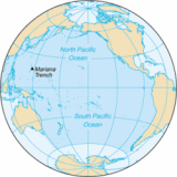
Encyclopedia
The
Pacific Ocean is the world's largest body of
water.
Overview
The ocean encompasses a third of the
Earth's surface, having an area of 179.7 million square kilometres —significantly larger than Earth's entire landmass, with room for another
Africa to spare. Extending approximately 15,500 kilometres from the
Bering Sea in the
Arctic to the icy margins of
Antarctica's
Ross Sea in the south , the Pacific reaches its greatest east-west width at about 5°N latitude, where it stretches approximately 19,800 kilometres from
Indonesia to the coast of
Colombia and
Peru. The western limit of the ocean is often placed at the
Strait of Malacca. The lowest point on earth—the
Mariana Trench—lies 10,911 metres below sea level. Its average depth is 4,300 metres .
The Pacific contains about 25,000
islands , the majority of which are found south of the
equator.
The Pacific Ocean is currently shrinking from
plate tectonics, while the
Atlantic Ocean is increasing in size.
Along the Pacific Ocean's irregular western margins lie many seas, the largest of which are the
Celebes Sea,
Coral Sea,
East China Sea,
Philippine Sea, Sea of Japan,
South China Sea, Sulu Sea,
Tasman Sea, and
Yellow Sea. The
Strait of Malacca joins the Pacific and the
Indian Oceans on the west, and the
Strait of Magellan links the Pacific with the Atlantic Ocean on the east. To the north, the
Bering Strait connects the Pacific with the
Arctic Ocean.
As the Pacific straddles the ± 180° meridian, the
West Pacific is actually in the
Eastern Hemisphere, while the
East Pacific is actually in the
Western Hemisphere.
For most of Magellan's voyage from the Strait of Magellan to the
Philippines, the explorer indeed found the ocean peaceful. However, the Pacific is not always peaceful. Many
tropical cyclones , batter the islands of the Pacific. The lands around the Pacific rim are full of
volcanoes and often affected by
earthquakes.
Tsunamis, caused by underwater earthquakes, have devastated many islands and destroyed entire towns.
Water characteristics
Water temperatures in the Pacific vary from freezing in the poleward areas to about 25-30 °
Celsius near the equator.
Salinity also varies latitudinally. Water near the equator is less salty than that found in the mid-latitudes because of abundant equatorial precipitation throughout the year. Poleward of the temperate latitudes salinity is also low, because little evaporation of seawater takes place in these frigid areas. The Pacific ocean is generally believed to be warmer than the Atlantic ocean.
The surface circulation of Pacific waters is generally clockwise in the
Northern Hemisphere and counter-clockwise in the
Southern Hemisphere. The North Equatorial Current, driven westward along latitude 15°N by the trade winds, turns north near the Philippines to become the warm Japan or Kuroshio Current.
Turning eastward at about 45°N, the Kuroshio forks and some waters move northward as the Aleutian Current, while the rest turn southward to rejoin the North Equatorial Current. The Aleutian Current branches as it approaches North America and forms the base of a counter-clockwise circulation in the Bering Sea. Its southern arm becomes the chilled slow, south-flowing California Current.
The South Equatorial Current, flowing west along the equator, swings southward east of
New Guinea, turns east at about 50°S, and joins the main westerly circulation of the Southern Pacific, which includes the Earth-circling
Antarctic Circumpolar Current. As it approaches the
Chilean coast, the South Equatorial Current divides; one branch flows around
Cape Horn and the other turns north to form the Peru or Humboldt Current.
Geology
The Andesite Line is the most significant regional distinction in the Pacific. It separates the deeper, alkaline
igneous rock of the Central Pacific Basin from the partially submerged continental areas of acidic igneous rock on its margins. The Andesite Line follows the western edge of the islands off
California and passes south of the
Aleutian arc, along the eastern edge of the
Kamchatka Peninsula, the
Kuril Islands,
Japan, the Mariana Islands, the
Solomon Islands, and
New Zealand. The dissimilarity continues northeastward along the western edge of the Albatross Cordillera along
South America to
Mexico, returning then to the islands off California.
Indonesia, the Philippines, Japan, New Guinea, and New Zealand—all eastward extensions of the continental blocks of
Australia and
Asia—lie outside the Andesite Line.
Within the closed loop of the Andesite Line are most of the deep troughs, submerged volcanic mountains, and oceanic volcanic islands that characterize the Central Pacific Basin. Here basaltic lavas gently flow out of rifts to build huge dome-shaped volcanic mountains whose eroded summits form island arcs, chains, and clusters. Outside the Andesite Line, volcanism is of the explosive type, and the
Pacific Ring of Fire is the world's foremost belt of explosive volcanism.
Landmasses
The largest landmass entirely within the Pacific Ocean is the island of New Guinea— the second largest island in the world. Almost all of the smaller islands of the Pacific lie between 30°N and 30°S, extending from
South-east Asia to
Easter Island; the rest of the Pacific Basin is almost entirely submerged.
The great triangle of
Polynesia, connecting
Hawaii, Easter Island, and New Zealand, encompasses the island arcs and clusters of the
Cook Islands,
Marquesas,
Samoa, Society,
Tokelau,
Tonga,
Tuamotu,
Tuvalu &
Wallis and Futuna islands.
North of the equator and west of the International Date Line are the numerous small islands of
Micronesia, including the
Caroline Islands, the
Marshall Islands, and the Mariana Islands.
In the southwestern corner of the Pacific lie the islands of
Melanesia, dominated by New Guinea. Other important island groups of Melanesia include the
Bismarck Archipelago,
Fiji,
New Caledonia, the
Solomon Islands, and
Vanuatu.
Islands in the Pacific Ocean are of four basic types: continental islands, high islands, coral reefs, and uplifted coral platforms. Continental islands lie outside the Andesite Line and include New Guinea, the islands of New Zealand, and the Philippines. These islands are structurally associated with nearby continents. High islands are of volcanic origin, and many contain active volcanoes. Among these are Bougainville, Hawaii, & the Solomon Islands.
The third and fourth types of islands are both the result of coralline island building. Coral reefs are low-lying structures that have built up on basaltic lava flows under the ocean's surface. One of the most dramatic is the
Great Barrier Reef off northeastern Australia. A second island type formed of coral is the uplifted coral platform, which is usually slightly larger than the low coral islands. Examples include
Banaba and Makatea in the Tuamotu group of
French Polynesia.
History and economy
Important human migrations occurred in the Pacific in prehistoric times, most notably those of the
Austronesians from the Asian edge of the ocean to
Tahiti and then to Hawaii and New Zealand, and much later, to Easter Island.
The ocean was sighted by Europeans early in the 16th century, first by
Vasco Núñez de Balboa and then by Ferdinand Magellan, who crossed the Pacific during his circumnavigation . In 1564,
conquistadors crossed the ocean from Mexico led by
Miguel López de Legazpi who sailed to the
Philippines and Mariana Islands. For the remainder of the
16th century,
Spanish influence was paramount, with ships sailing from Spain to the Philippines, New Guinea, and the Solomon Islands. The
Manila Galleons linked
Manila and
Acapulco.
During the
17th century, the
Dutch, sailing around southern Africa, dominated discovery and trade;
Abel Janszoon Tasman discovered
Tasmania and New Zealand in 1642. The
18th century marked a burst of exploration by the
Russians in
Alaska and the Aleutian Islands, the
French in Polynesia, and the British in the three voyages of
James Cook .
Growing
imperialism during the
19th century resulted in the occupation of much of Oceania by Great Britain and France, followed by the
United States. Significant contributions to oceanographic knowledge were made by the voyages of the
HMS Beagle in the 1830s, with
Charles Darwin aboard; the HMS
Challenger during the 1870s; the USS
Tuscarora ; and the German Gazelle . Although the United States took the Philippines in 1898, Japan controlled the western Pacific by 1914 and occupied many other islands during
World War II. By the end of the war, the
U.S. Pacific Fleet was the virtual master of the ocean.
Seventeen independent states are located in the Pacific: Australia,
Fiji, Japan, Kiribati, Marshall Islands, Micronesia,
Nauru, New Zealand,
Palau, Papua New Guinea, the Philippines, Samoa, Solomon Islands,
Republic of China , Tonga, Tuvalu, and
Vanuatu. Eleven of these nations have achieved full independence since 1960. The Northern Mariana Islands are self-governing with external affairs handled by the United States, and
Cook Islands and
Niue are in similar relationships with New Zealand. Also within the Pacific is the U.S. state of Hawaii and several island territories and possessions of Australia, Chile,
Ecuador, France, Japan, New Zealand, the
United Kingdom, and the United States.
The exploitation of the Pacific's mineral wealth is hampered by the ocean's great depths. In shallow waters of the continental shelves off the coasts of Australia and New Zealand, petroleum and natural gas are extracted, and pearls are harvested along the coasts of Australia, Japan, Papua New Guinea,
Nicaragua,
Panama, and the Philippines, although in sharply declining volume in some cases. The Pacific's greatest asset is its fish. The shoreline waters of the continents and the more temperate islands yield
herring,
salmon,
sardines,
snapper,
swordfish, and
tuna, as well as
shellfish.
In 1986, the member nations of the
South Pacific Forum declared the area a nuclear-free zone in an effort to halt
nuclear testing and prevent the dumping of
nuclear waste there.
Major ports and harbours
One of the world's oldest civilization [i]s, Korea began with the founding of Gojoseon [i] in 2333 ...
...
,
Ecuador- Hong Kong, People's Republic of China
- Honolulu, Hawaii, United States
- Kitimat, British Columbia, Canada
- Keelung, Taiwan
- Kobe, Japan
- Long Beach, California, United States
- Los Angeles, California, United States
- Metro Manila, Philippines
- Panama City, Panama
- Portland, Oregon, United States
- Prince Rupert, British Columbia, Canada
- San Diego, California, United States
- San Francisco, California, United States
- Sapporo, Japan
- Seattle, Washington, United States
- Shanghai, People's Republic of China
- Singapore
- Sydney, New South Wales, Australia
- Tijuana, Mexico
- Valparaiso, Chile
- Vancouver, British Columbia, Canada
- Victoria, British Columbia, Canada
- Vladivostok, Russia
- Yokohama, Japan
Further reading
- Based on public domain text from US Naval Oceanographer******
External links
- , from the Woods Hole Oceanographic Institution
- Viewable on-line collection of observational data
- Plot and download ocean observations
-
- Near-realtime Pacific Ocean Surface Currents derived from satellite altimeter and scatterometer data
- Realtime Pacific Ocean data
- Realtime Pacific Ocean El Niño buoy data
-