

May 2007 Tornado Outbreak
Encyclopedia
The May 2007 Tornado Outbreak was an extended tornado outbreak
that started on May 4, 2007, affecting portions of the Central United States
. The most destructive tornado
in the outbreak occurred on the evening of May 4 in western Kansas
, where about 95% of the city of Greensburg
in Kiowa County
was destroyed by an EF5
tornado. The supercell killed at least 13 people including 11 in Greensburg and two in Pratt County
by a separate tornado. At least 60 people were injured in Greensburg alone. It was the strongest tornado of an outbreak which included several other tornadoes reported across Oklahoma
, Colorado
, Kansas
and South Dakota
that occurred on the same night. 25 tornadoes were confirmed that night.
The outbreak did not end there; a total of 84 tornadoes were confirmed reported on May 5 in the same area. Most were in open country but one fatality was reported in Ottawa County, Kansas
near a county lake. Fourteen more tornadoes were confirmed on May 6 in the same general area before the activity subsided.
with a warm front
to the north over Nebraska and Missouri. On May 4, the low stalled over the High Plains
and additional moisture coming from the Gulf of Mexico
moved in behind the warm front and increased amounts of instability across much of the region, with CAPE
values as high as 5,500 J/kg. In addition, the dry line
, which marks a divided line between the dry and humid air mass, was positioned over the southern High Plains. This allowed for the initiation of scattered supercells on May 4. High wind shear
also allowed for intense rotation in the atmosphere. All the ingredients were present for the developing of supercell
thunderstorm
s producing damaging wind, large hail and tornadoes.
The Storm Prediction Center
issued a moderate risk for severe weather across western Kansas
and small portions of Oklahoma
, Colorado
and Nebraska
for May 4, while temperatures were in the mid to high 80s°F (near 30°C). The atmosphere remained capped
for much of the day, but storms began to develop in the late afternoon
hours in western Oklahoma and the eastern Texas Panhandle
. The most intense supercells developed in the early evening
hours across northwestern Oklahoma and southwestern Kansas. They eventually produced 25 tornadoes, including the devastating Greensburg
tornado and three other extremely large tornadoes which followed the Greensburg tornado late that evening. The supercells remained intact well into the overnight
hours as the extremely unstable air mass precluded rapid dissipation expected with the loss of daytime heating which would normally be expected in the Plains. The last tornado of the night did not lift until shortly after 2:00 a.m. early on May 5.
On May 5, the SPC issued a high risk of severe weather for Central Kansas and central Nebraska, while moderate and slight risks for severe weather extended for areas far beyond. The low pressure system in place moved northward, but the extending front had barely moved. The storms were quick to develop. Severe weather reports were already coming in by late morning, and the first tornado reports came in during the early afternoon hours. The most intense activity took place during the late afternoon and evening hours as supercells developed along a long line from South Dakota
to North Texas
. Over 80 tornadoes were confirmed that day, along with hail as large as softball
s and straight–line winds as strong as 90 mph (145 km/h). The activity weakened in the late evening, but not before the last tornadoes were reported in Iowa
in the overnight hours.
The low gradually weakened and became less conducive for severe weather development on May 6. Nonetheless, the SPC issued a moderate risk for severe storms over parts of central Kansas and northern Oklahoma as the trough remained in place. The activity was far less than on the two previous days, however there were still several additional tornadoes across the Plains (all of them weak, mostly EF0). The system finally left the area on May 7 and did not produce any more significant severe weather.
 The storm that would affect Greensburg (located approximately 110 miles (177 km) west of Wichita
) began forming after 5:00 pm CDT (2200 UTC) in the northeastern corner of the Texas Panhandle
, and went through phases in the early evening across the Oklahoma Panhandle
with a few isolated tornadoes. It slowly organized itself as it moved northeast through portions of Oklahoma, and then into Kansas. The first tornado warning
with this cell was issued at 8:35 pm CDT (0135 UTC) for Clark County, Kansas
, and the tornado first touched down at about 9:00 pm CDT (0200 UTC). Several storm chaser
s captured the formation of a tornado southwest of Greensburg around 9:20 pm CDT (0220 UTC).
The tornado apparently strengthened as it neared Greensburg, and at 9:38 pm CDT (0238 UTC), storm chasers reported that it had grown to over 1/2 mi in diameter. Several satellite tornadoes were observed as the very large wedge approached the city of Greensburg. At 9:41 pm CDT (0241 UTC) the National Weather Service
office in Dodge City
issued a rare Tornado emergency
for Greensburg. A tornado emergency is an unofficial product used only for extremely life–threatening situations when a large and likely violent tornado is on the ground and approaching a populated area. The tornado plowed through Greensburg shortly after it was intercepted by storm chasers. It was an estimated 1.7 miles (2.7 km) in diameter and was later confirmed to have been an EF5 on the Enhanced Fujita Scale
(the highest possible rating). Based on the damage produced, winds inside the tornado were estimated to have been in excess of 205 mph (330 km/h).
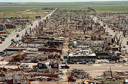 The mayor of Greensburg stated that 95% of his community was destroyed. Many houses were flattened or even blown away. Kiowa County Memorial Hospital sustained heavy damage, and as many as 30 people may have initially been trapped inside. A motel on the west edge of the city, two schools, a tractor supply company, the Greensburg City Hall
and other businesses fell victim to the violent winds and were destroyed or flattened. The city's water tower
was completely toppled and smashed. The visitor's center at the Big Well
(which is the world's largest hand-dug well) was completely destroyed. Train cars were also reported to be overturned and hazardous materials teams were called to inspect the wreckage. A tank car was carrying about 14,000 gallons (53,000 liters) of ammonia
and the substance started to leak from the tank when workers were starting to lift back the tanker. The courthouse
and the grain elevator
were spared the worst of the tornado's effects. Meanwhile, the Greensburg meteorite
, which was feared to have been blown away, was found and recovered a few days afterwards. The tornado continued north before dissipating, and by several accounts continued to grow as it left the city. The total path length was 22 miles (35 km), and the width of the funnel reached 1.7 miles (2.7 km).
After extensive surveys in the area, the National Weather Service office in Dodge City revealed that a second large tornado later developed just a few miles east of the Greensburg wedge. The new tornado rapidly grew to about 2 miles (3.2 km) in diameter as it moved northeast. In Pratt County
the tornado destroyed more homes, including one that was swept off its foundation. The tornado also affected several other communities, including Trousdale
in Edwards County
and Macksville
in Stafford County
. The same supercell
spawned additional tornadoes that caused significant damage across Barton County where it affected the cities of Ellinwood
and Claflin
about two hours after the Greensburg tornado. Another tornado later hit the Holyrood
area causing additional damage. The tornado destroyed 961 homes, caused major damage to 216 others and minor damage to 307 other houses.
After additional surveys, NWS Dodge City had confirmed 12 tornado tracks by the Greensburg supercell in Kansas alone on May 4 including the two satellite tornadoes and an additional brief tornado east of Greensburg at 9:55 p.m. CDT at the same time the main tornado was weakening and dissipating a few minutes after at 10:05 PM CDT. The new Enhanced Fujita Scale
was implemented on February 1, 2007, and the Greensburg tornado was the first tornado rated EF5 on it. Including tornadoes from the older Fujita Scale
, the most recent F5 to hit the United States had been on May 3, 1999 during the 1999 Oklahoma tornado outbreak, when a tornado destroyed Bridge Creek
.
This tornado event surpassed the number of fatalities registered on May 4, 2003 during the May 2003 tornado outbreak sequence
when eight people were killed by three separate tornadoes that affected areas around Kansas City and points south and west of the city; the last major deadly outbreak registered in Kansas prior to the Greensburg event. It was also the deadliest day and single tornado to hit the state of Kansas since an F5 tornado (which was also the last F5 in that state before this event), hit Wichita and Andover
in Sedgwick
and Butler
counties, killing 17 during the Andover, Kansas Tornado Outbreak
on April 26, 1991. The Greensburg event was also the deadliest single tornado in the United States since a tornado hit Volusia County
in central Florida
on February 2, 2007
where 13 were killed in an EF3 tornado. It was also the deadliest day for tornadoes since 20 people were killed in six communities on March 1, 2007.
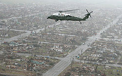 Hours after the tornado hit, Greensburg was judged unsafe and was fully evacuated. Some of the injured were transferred to hospitals in Dodge City
and Wichita
. The Kansas National Guard
was called in to assist in the security measures. Over 100 Red Cross officials were called in while some worked with the Federal Emergency Management Agency
for the recovery efforts. Shelters were established at the Haviland High School and Barclay College
in nearby Haviland, Kansas
and the Oddfellow Lodge in Macksville, Kansas
. After the tornado, looting
was reported in the community and at least seven suspects, including four soldiers that were not part of the relief effort and went to Greensburg on their own, were arrested and faced charges of burglary
and theft. A dusk-to-dawn curfew
was put in place in the community after the tornado hit.
The American Red Cross
maintained a list of "Safe and Well" families at their website disastersafe.redcross.org.
Meanwhile, officials also set a shelter for lost and injured animals as they reported to had found 163 animals alive in Greensburg after the tornado. Kansas Governor
Kathleen Sebelius
and President
George W. Bush
both declared Kiowa County a disaster area
.
Total damage from the outbreak was estimated at about $268 million, and insured damage from the Greensburg tornado alone was estimated at $153 million.
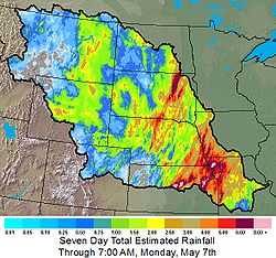 In addition to the tornadoes, widespread flood
ing occurred across central North America as a result of the same system producing continuous thunderstorms. There were two major reasons for the flooding: The storm system itself moved very slowly, having produced significant tornado outbreaks in almost the same places for three days. In addition, the storms moved along each others' paths, so one storm dropped heavy rains on the same place that the storm before it did (this is also known as "training
").
 Across portions of eastern Nebraska and western Iowa, rainfall amounts exceeded locally 6 inches (152 mm). In northeastern and central Kansas, rainfall amounts approached 5 – 6 inches locally (125 – 150 mm). In North Dakota
, southern Manitoba
and southern Saskatchewan
, heavy rainfalls of 1 – 3 inches (25 – 75 mm) fell from this system from May 4 to May 7. Similar amounts were reported in Alberta
on May 3 and May 4.
Some of the worst flooding affected Topeka, Kansas
, where several rescues had to be made, and the Kansas City
Metro Area, where several roads were closed. In neighboring Missouri
, levees broke along the Missouri River
which caused extensive flooding to hundreds of homes and the northwest and central part of the state. The National Guard
were assisting on filling sandbags to protect homes, schools and plants across the state which experienced some of the worst flooding since the Great Flood of 1993
which affected most of the Mississippi River Valley. Torrential rains on May 10 had also caused flooding in parts of southern Missouri as well as in eastern Kansas. The heavy rains also affected activities surrounding the Riverfest (Wichita River Festival) which postponed some events until May 14. The Arkansas River
reached record levels near Haven
when it crested at 13.08 feet on May 8. Some flooding into low lying areas was also observed in the Wichita Metropolitan Area. Rainfall amounts in southern and southeastern Kansas also exceeded 6 inches (152 mm) over a two day period on May 6 and May 7. There were several reports of farmers who lost several cattle who have been toss by the high water levels.
In Aberdeen, South Dakota
, 7.75 inches (197 mm) of rain fell the evening of May 5 into the early morning hours of May 6, causing significant flooding in some areas around the city. It was also the city's new 24–hour record rainfall, breaking the old mark of 5.2 inches (132 mm) set in June 1978. The highest unofficial rainfall total was reported in Epiphany, South Dakota where as much as 10 inches (254 mm) fell during the weekend. The highest official report of rain, 8.73 inches (222 mm) at Columbia, South Dakota
, set a new official 24–hour May rainfall record for the entire state of South Dakota.
In southern Oklahoma City
and surrounding communities, strong straightline winds caused damage to several buildings and downed trees and power lines in the early morning hours of May 7, with cleanup efforts being complicated due to flooding rains accompanying the storm. About 11,000 homes were without power during the event. There were also reports of floods across many other areas in Oklahoma. Oklahoma Governor
Brad Henry
had declared a state of emergency
for all 77 counties across the state due to all the severe weather including the tornadoes, the flash floods and hail.
Snow was also reported across higher elevations in Colorado, Wyoming
, Nebraska
and Utah
with local amounts of up to one foot (30 cm) across central Colorado.
Tornado outbreak
While there is no single agreed upon definition, generally at least 6-10 tornadoes produced by the same synoptic scale weather system is considered a tornado outbreak. The tornadoes usually occur within the same day, or continue into the early morning hours of the succeeding day, and within the...
that started on May 4, 2007, affecting portions of the Central United States
Central United States
The Central United States is sometimes conceived as between the Eastern United States and Western United States as part of a three-region model, roughly coincident with the Midwestern United States plus the western and central portions of the Southern United States; the term is also sometimes used...
. The most destructive tornado
Tornado
A tornado is a violent, dangerous, rotating column of air that is in contact with both the surface of the earth and a cumulonimbus cloud or, in rare cases, the base of a cumulus cloud. They are often referred to as a twister or a cyclone, although the word cyclone is used in meteorology in a wider...
in the outbreak occurred on the evening of May 4 in western Kansas
Kansas
Kansas is a US state located in the Midwestern United States. It is named after the Kansas River which flows through it, which in turn was named after the Kansa Native American tribe, which inhabited the area. The tribe's name is often said to mean "people of the wind" or "people of the south...
, where about 95% of the city of Greensburg
Greensburg, Kansas
Greensburg is a city in and the county seat of Kiowa County, Kansas, United States. As of the 2010 census, the city population was 777. Greensburg is also home to the world's largest hand-dug well....
in Kiowa County
Kiowa County, Kansas
Kiowa County is a county located in the U.S. state of Kansas. As of the 2010 census, the county population was 2,553...
was destroyed by an EF5
Enhanced Fujita Scale
The Enhanced Fujita Scale rates the strength of tornadoes in the United States based on the damage they cause.Implemented in place of the Fujita scale introduced in 1971 by Ted Fujita, it began operational use on February 1, 2007. The scale has the same basic design as the original Fujita scale:...
tornado. The supercell killed at least 13 people including 11 in Greensburg and two in Pratt County
Pratt County, Kansas
Pratt County is a county located in the U.S. state of Kansas. As of the 2010 census, the county population was 9,656. The largest city and county seat is Pratt.-19th century:...
by a separate tornado. At least 60 people were injured in Greensburg alone. It was the strongest tornado of an outbreak which included several other tornadoes reported across Oklahoma
Oklahoma
Oklahoma is a state located in the South Central region of the United States of America. With an estimated 3,751,351 residents as of the 2010 census and a land area of 68,667 square miles , Oklahoma is the 28th most populous and 20th-largest state...
, Colorado
Colorado
Colorado is a U.S. state that encompasses much of the Rocky Mountains as well as the northeastern portion of the Colorado Plateau and the western edge of the Great Plains...
, Kansas
Kansas
Kansas is a US state located in the Midwestern United States. It is named after the Kansas River which flows through it, which in turn was named after the Kansa Native American tribe, which inhabited the area. The tribe's name is often said to mean "people of the wind" or "people of the south...
and South Dakota
South Dakota
South Dakota is a state located in the Midwestern region of the United States. It is named after the Lakota and Dakota Sioux American Indian tribes. Once a part of Dakota Territory, South Dakota became a state on November 2, 1889. The state has an area of and an estimated population of just over...
that occurred on the same night. 25 tornadoes were confirmed that night.
The outbreak did not end there; a total of 84 tornadoes were confirmed reported on May 5 in the same area. Most were in open country but one fatality was reported in Ottawa County, Kansas
Ottawa County, Kansas
Ottawa County is a county located in the U.S. state of Kansas. As of the 2010 census, the county population was 6,091. The largest city and county seat is Minneapolis...
near a county lake. Fourteen more tornadoes were confirmed on May 6 in the same general area before the activity subsided.
Meteorological synopsis
This severe weather outbreak can be traced back to a powerful, slow-moving low pressure areaLow pressure area
A low-pressure area, or "low", is a region where the atmospheric pressure at sea level is below that of surrounding locations. Low-pressure systems form under areas of wind divergence which occur in upper levels of the troposphere. The formation process of a low-pressure area is known as...
with a warm front
Warm front
A warm front is a density discontinuity located at the leading edge of a homogeneous warm air mass, and is typically located on the equator-facing edge of an isotherm gradient...
to the north over Nebraska and Missouri. On May 4, the low stalled over the High Plains
High Plains (United States)
The High Plains are a subregion of the Great Plains mostly in the Western United States, but also partly in the Midwest states of Nebraska, Kansas, and South Dakota, generally encompassing the western part of the Great Plains before the region reaches the Rocky Mountains...
and additional moisture coming from the Gulf of Mexico
Gulf of Mexico
The Gulf of Mexico is a partially landlocked ocean basin largely surrounded by the North American continent and the island of Cuba. It is bounded on the northeast, north and northwest by the Gulf Coast of the United States, on the southwest and south by Mexico, and on the southeast by Cuba. In...
moved in behind the warm front and increased amounts of instability across much of the region, with CAPE
Convective available potential energy
In meteorology, convective available potential energy , sometimes, simply, available potential energy , is the amount of energy a parcel of air would have if lifted a certain distance vertically through the atmosphere...
values as high as 5,500 J/kg. In addition, the dry line
Dry line
A dry line separates moist air from the Gulf of Mexico and dry desert air from the south-western states . The dry line is an important factor in severe weather frequency in the Great Plains of North America...
, which marks a divided line between the dry and humid air mass, was positioned over the southern High Plains. This allowed for the initiation of scattered supercells on May 4. High wind shear
Wind shear
Wind shear, sometimes referred to as windshear or wind gradient, is a difference in wind speed and direction over a relatively short distance in the atmosphere...
also allowed for intense rotation in the atmosphere. All the ingredients were present for the developing of supercell
Supercell
A supercell is a thunderstorm that is characterized by the presence of a mesocyclone: a deep, continuously-rotating updraft. For this reason, these storms are sometimes referred to as rotating thunderstorms...
thunderstorm
Thunderstorm
A thunderstorm, also known as an electrical storm, a lightning storm, thundershower or simply a storm is a form of weather characterized by the presence of lightning and its acoustic effect on the Earth's atmosphere known as thunder. The meteorologically assigned cloud type associated with the...
s producing damaging wind, large hail and tornadoes.
The Storm Prediction Center
Storm Prediction Center
The Storm Prediction Center , located in Norman, Oklahoma, is tasked with forecasting the risk of severe thunderstorms and tornadoes in the contiguous United States. The agency issues convective outlooks, mesoscale discussions, and watches as a part of this process...
issued a moderate risk for severe weather across western Kansas
Kansas
Kansas is a US state located in the Midwestern United States. It is named after the Kansas River which flows through it, which in turn was named after the Kansa Native American tribe, which inhabited the area. The tribe's name is often said to mean "people of the wind" or "people of the south...
and small portions of Oklahoma
Oklahoma
Oklahoma is a state located in the South Central region of the United States of America. With an estimated 3,751,351 residents as of the 2010 census and a land area of 68,667 square miles , Oklahoma is the 28th most populous and 20th-largest state...
, Colorado
Colorado
Colorado is a U.S. state that encompasses much of the Rocky Mountains as well as the northeastern portion of the Colorado Plateau and the western edge of the Great Plains...
and Nebraska
Nebraska
Nebraska is a state on the Great Plains of the Midwestern United States. The state's capital is Lincoln and its largest city is Omaha, on the Missouri River....
for May 4, while temperatures were in the mid to high 80s°F (near 30°C). The atmosphere remained capped
Capping inversion
A capping inversion is an elevated inversion layer that caps a convective boundary layer.The boundary layer is the part of the atmosphere which is closest to the ground. Normally, the sun heats the ground, which in turn heats the air just above it. Thermals form when this warm air rises into the...
for much of the day, but storms began to develop in the late afternoon
Afternoon
Afternoon is the time of day from noon to about 18:00.The term should not be confused with "after noon" , which is a translation of the Latin "post meridiem" as used in the 12-hour clock, meaning a time of day from noon to midnight.In Australia and New Zealand, the word "arvo" is a slang term for...
hours in western Oklahoma and the eastern Texas Panhandle
Texas Panhandle
The Texas Panhandle is a region of the U.S. state of Texas consisting of the northernmost 26 counties in the state. The panhandle is a rectangular area bordered by New Mexico to the west and Oklahoma to the north and east...
. The most intense supercells developed in the early evening
Evening
Evening is the period between the late afternoon and night when daylight is decreasing, around dinner time at 6pm. Though the term is subjective, evening is typically understood to begin before sunset, during the close of the standard business day and extend until nightfall, the beginning of night...
hours across northwestern Oklahoma and southwestern Kansas. They eventually produced 25 tornadoes, including the devastating Greensburg
Greensburg, Kansas
Greensburg is a city in and the county seat of Kiowa County, Kansas, United States. As of the 2010 census, the city population was 777. Greensburg is also home to the world's largest hand-dug well....
tornado and three other extremely large tornadoes which followed the Greensburg tornado late that evening. The supercells remained intact well into the overnight
Overnight
Overnight is a 2003 documentary by Tony Montana and Mark Brian Smith. The film details the rise and fall of filmmaker and musician Troy Duffy, the writer-director of The Boondock Saints, and was filmed at his request....
hours as the extremely unstable air mass precluded rapid dissipation expected with the loss of daytime heating which would normally be expected in the Plains. The last tornado of the night did not lift until shortly after 2:00 a.m. early on May 5.
On May 5, the SPC issued a high risk of severe weather for Central Kansas and central Nebraska, while moderate and slight risks for severe weather extended for areas far beyond. The low pressure system in place moved northward, but the extending front had barely moved. The storms were quick to develop. Severe weather reports were already coming in by late morning, and the first tornado reports came in during the early afternoon hours. The most intense activity took place during the late afternoon and evening hours as supercells developed along a long line from South Dakota
South Dakota
South Dakota is a state located in the Midwestern region of the United States. It is named after the Lakota and Dakota Sioux American Indian tribes. Once a part of Dakota Territory, South Dakota became a state on November 2, 1889. The state has an area of and an estimated population of just over...
to North Texas
North Texas
North Texas is a distinct cultural and geographic area forming the central-northeastern section of the U.S. state of Texas. North Texas is generally considered to include the area south of Oklahoma, east of Abilene, and north of Waco...
. Over 80 tornadoes were confirmed that day, along with hail as large as softball
Softball
Softball is a bat-and-ball sport played between two teams of 10 to 14 players. It is a direct descendant of baseball although there are some key differences: softballs are larger than baseballs, and the pitches are thrown underhand rather than overhand...
s and straight–line winds as strong as 90 mph (145 km/h). The activity weakened in the late evening, but not before the last tornadoes were reported in Iowa
Iowa
Iowa is a state located in the Midwestern United States, an area often referred to as the "American Heartland". It derives its name from the Ioway people, one of the many American Indian tribes that occupied the state at the time of European exploration. Iowa was a part of the French colony of New...
in the overnight hours.
The low gradually weakened and became less conducive for severe weather development on May 6. Nonetheless, the SPC issued a moderate risk for severe storms over parts of central Kansas and northern Oklahoma as the trough remained in place. The activity was far less than on the two previous days, however there were still several additional tornadoes across the Plains (all of them weak, mostly EF0). The system finally left the area on May 7 and did not produce any more significant severe weather.
Confirmed tornadoes
Storm history and damage
Wichita, Kansas
Wichita is the largest city in the U.S. state of Kansas.As of the 2010 census, the city population was 382,368. Located in south-central Kansas on the Arkansas River, Wichita is the county seat of Sedgwick County and the principal city of the Wichita metropolitan area...
) began forming after 5:00 pm CDT (2200 UTC) in the northeastern corner of the Texas Panhandle
Texas Panhandle
The Texas Panhandle is a region of the U.S. state of Texas consisting of the northernmost 26 counties in the state. The panhandle is a rectangular area bordered by New Mexico to the west and Oklahoma to the north and east...
, and went through phases in the early evening across the Oklahoma Panhandle
Oklahoma Panhandle
The Oklahoma Panhandle is the extreme western region of the state of Oklahoma, comprising Cimarron County, Texas County, and Beaver County. Its name comes from the similarity of shape to the handle of a cooking pan....
with a few isolated tornadoes. It slowly organized itself as it moved northeast through portions of Oklahoma, and then into Kansas. The first tornado warning
Tornado warning
A tornado warning is an alert issued by government weather services to warn that severe thunderstorms with tornadoes may be imminent. It can be issued after a tornado or funnel cloud has been spotted by eye, or more commonly if there are radar indications of tornado formation...
with this cell was issued at 8:35 pm CDT (0135 UTC) for Clark County, Kansas
Clark County, Kansas
Clark County is a county located in Southwest Kansas, in the Central United States. As of the 2010 census, the county population was 2,215...
, and the tornado first touched down at about 9:00 pm CDT (0200 UTC). Several storm chaser
Storm chasing
Storm chasing is broadly defined as the pursuit of any severe weather condition, regardless of motive, which can be curiosity, adventure, scientific exploration or for news professions/media coverage....
s captured the formation of a tornado southwest of Greensburg around 9:20 pm CDT (0220 UTC).
The tornado apparently strengthened as it neared Greensburg, and at 9:38 pm CDT (0238 UTC), storm chasers reported that it had grown to over 1/2 mi in diameter. Several satellite tornadoes were observed as the very large wedge approached the city of Greensburg. At 9:41 pm CDT (0241 UTC) the National Weather Service
National Weather Service
The National Weather Service , once known as the Weather Bureau, is one of the six scientific agencies that make up the National Oceanic and Atmospheric Administration of the United States government...
office in Dodge City
Dodge City, Kansas
Dodge City is a city in, and the county seat of, Ford County, Kansas, United States. Named after nearby Fort Dodge, the city is famous in American culture for its history as a wild frontier town of the Old West. As of the 2010 census, the city population was 27,340.-History:The first settlement of...
issued a rare Tornado emergency
Tornado emergency
A Tornado Emergency is enhanced wording of tornado warnings used by the National Weather Service in the United States during significant tornado occurrences in highly populated areas...
for Greensburg. A tornado emergency is an unofficial product used only for extremely life–threatening situations when a large and likely violent tornado is on the ground and approaching a populated area. The tornado plowed through Greensburg shortly after it was intercepted by storm chasers. It was an estimated 1.7 miles (2.7 km) in diameter and was later confirmed to have been an EF5 on the Enhanced Fujita Scale
Enhanced Fujita Scale
The Enhanced Fujita Scale rates the strength of tornadoes in the United States based on the damage they cause.Implemented in place of the Fujita scale introduced in 1971 by Ted Fujita, it began operational use on February 1, 2007. The scale has the same basic design as the original Fujita scale:...
(the highest possible rating). Based on the damage produced, winds inside the tornado were estimated to have been in excess of 205 mph (330 km/h).
City hall
In local government, a city hall, town hall or a municipal building or civic centre, is the chief administrative building of a city...
and other businesses fell victim to the violent winds and were destroyed or flattened. The city's water tower
Water tower
A water tower or elevated water tower is a large elevated drinking water storage container constructed to hold a water supply at a height sufficient to pressurize a water distribution system....
was completely toppled and smashed. The visitor's center at the Big Well
Big Well (Kansas)
The Big Well, in Greensburg, Kansas, USA, is a water well that was designed to provide water for the Santa Fe and Rock Island railroads. It was built in 1887 at a cost of $45,000, and served as the municipal water supply until 1932....
(which is the world's largest hand-dug well) was completely destroyed. Train cars were also reported to be overturned and hazardous materials teams were called to inspect the wreckage. A tank car was carrying about 14,000 gallons (53,000 liters) of ammonia
Ammonia
Ammonia is a compound of nitrogen and hydrogen with the formula . It is a colourless gas with a characteristic pungent odour. Ammonia contributes significantly to the nutritional needs of terrestrial organisms by serving as a precursor to food and fertilizers. Ammonia, either directly or...
and the substance started to leak from the tank when workers were starting to lift back the tanker. The courthouse
Courthouse
A courthouse is a building that is home to a local court of law and often the regional county government as well, although this is not the case in some larger cities. The term is common in North America. In most other English speaking countries, buildings which house courts of law are simply...
and the grain elevator
Grain elevator
A grain elevator is a tower containing a bucket elevator, which scoops up, elevates, and then uses gravity to deposit grain in a silo or other storage facility...
were spared the worst of the tornado's effects. Meanwhile, the Greensburg meteorite
Meteorite
A meteorite is a natural object originating in outer space that survives impact with the Earth's surface. Meteorites can be big or small. Most meteorites derive from small astronomical objects called meteoroids, but they are also sometimes produced by impacts of asteroids...
, which was feared to have been blown away, was found and recovered a few days afterwards. The tornado continued north before dissipating, and by several accounts continued to grow as it left the city. The total path length was 22 miles (35 km), and the width of the funnel reached 1.7 miles (2.7 km).
After extensive surveys in the area, the National Weather Service office in Dodge City revealed that a second large tornado later developed just a few miles east of the Greensburg wedge. The new tornado rapidly grew to about 2 miles (3.2 km) in diameter as it moved northeast. In Pratt County
Pratt County, Kansas
Pratt County is a county located in the U.S. state of Kansas. As of the 2010 census, the county population was 9,656. The largest city and county seat is Pratt.-19th century:...
the tornado destroyed more homes, including one that was swept off its foundation. The tornado also affected several other communities, including Trousdale
Trousdale, Kansas
Trousdale is an unincorporated community in Lincoln Township, Edwards County, Kansas, United States.-History:It began when a railroad junction was constructed in 1915. It is named for a Newton, Kansas resident who owned land in the vicinity...
in Edwards County
Edwards County, Kansas
Edwards County is a county located in Southwest Kansas, in the Central United States. As of the 2010 census, the county population was 3,037...
and Macksville
Macksville, Kansas
Macksville is a city in Stafford County, Kansas, United States. As of the 2010 census, the city population was 549.-Geography:According to the United States Census Bureau, the city has a total area of , all of it land.-Demographics:...
in Stafford County
Stafford County, Kansas
Stafford County is a county located in the U.S. state of Kansas. As of the 2010 census, the county population was 4,437. Its county seat is St. John...
. The same supercell
Supercell
A supercell is a thunderstorm that is characterized by the presence of a mesocyclone: a deep, continuously-rotating updraft. For this reason, these storms are sometimes referred to as rotating thunderstorms...
spawned additional tornadoes that caused significant damage across Barton County where it affected the cities of Ellinwood
Ellinwood, Kansas
Ellinwood is a city in the southeast corner of Barton County, Kansas, United States. As of the 2010 census, the city population was 2,131.-History:...
and Claflin
Claflin, Kansas
Claflin is a city in Barton County, Kansas, United States. As of the 2010 census, the city population was 645.-Geography:Claflin is located at . According to the United States Census Bureau, the city has a total area of , all of it land.-Demographics:As of the census of 2000, there were 705...
about two hours after the Greensburg tornado. Another tornado later hit the Holyrood
Holyrood, Kansas
Holyrood is a city in Ellsworth County, Kansas, United States. As of the 2010 census, the city population was 447.-Geography:Holyrood is located at . According to the United States Census Bureau, the city has a total area of , all land.-Demographics:As of the census of 2000, there were 464...
area causing additional damage. The tornado destroyed 961 homes, caused major damage to 216 others and minor damage to 307 other houses.
After additional surveys, NWS Dodge City had confirmed 12 tornado tracks by the Greensburg supercell in Kansas alone on May 4 including the two satellite tornadoes and an additional brief tornado east of Greensburg at 9:55 p.m. CDT at the same time the main tornado was weakening and dissipating a few minutes after at 10:05 PM CDT. The new Enhanced Fujita Scale
Enhanced Fujita Scale
The Enhanced Fujita Scale rates the strength of tornadoes in the United States based on the damage they cause.Implemented in place of the Fujita scale introduced in 1971 by Ted Fujita, it began operational use on February 1, 2007. The scale has the same basic design as the original Fujita scale:...
was implemented on February 1, 2007, and the Greensburg tornado was the first tornado rated EF5 on it. Including tornadoes from the older Fujita Scale
Fujita scale
The Fujita scale , or Fujita-Pearson scale, is a scale for rating tornado intensity, based primarily on the damage tornadoes inflict on human-built structures and vegetation...
, the most recent F5 to hit the United States had been on May 3, 1999 during the 1999 Oklahoma tornado outbreak, when a tornado destroyed Bridge Creek
Bridge Creek, Oklahoma
Bridge Creek is a town in Grady County, Oklahoma, United States. As of the 2006 US Census estimate, the town is estimated to have a total population of 340.-Geography:Bridge Creek is located at ....
.
This tornado event surpassed the number of fatalities registered on May 4, 2003 during the May 2003 tornado outbreak sequence
May 2003 tornado outbreak sequence
The May 2003 tornado outbreak sequence in the United States was a series of tornado outbreaks that occurred from May 3 to May 11, 2003. Tornadoes began occurring over the affected area on April 30, but the most prolific continuous period was the seven day period of May 4–10...
when eight people were killed by three separate tornadoes that affected areas around Kansas City and points south and west of the city; the last major deadly outbreak registered in Kansas prior to the Greensburg event. It was also the deadliest day and single tornado to hit the state of Kansas since an F5 tornado (which was also the last F5 in that state before this event), hit Wichita and Andover
Andover, Kansas
Andover is a city in Butler and Sedgwick counties in the U.S. state of Kansas. As of the 2010 census, the city population was 11,791. Located almost entirely in Butler County, it is part of the Wichita Metropolitan Statistical Area...
in Sedgwick
Sedgwick County, Kansas
Sedgwick County is a county located in the U.S. state of Kansas. The county's population was 498,365 for the 2010 census. The largest city and county seat is Wichita. The county was named after General John Sedgwick...
and Butler
Butler County, Kansas
Butler County is a county located in South Central Kansas, in the Central United States. As of the 2010 census, the county population was 65,880. Its county seat and most populous city is El Dorado. The county is a part of the Wichita Metropolitan Statistical Area.-19th century:It was named in...
counties, killing 17 during the Andover, Kansas Tornado Outbreak
Andover, Kansas Tornado Outbreak
The 1991 Andover, Kansas tornado outbreak was a violent outbreak of 55 tornadoes which took place on April 26, 1991, killing 24 people and injuring hundreds more. The Andover outbreak was featured in two different documentaries: the first one was Enemy Wind, a documentary produced by The Weather...
on April 26, 1991. The Greensburg event was also the deadliest single tornado in the United States since a tornado hit Volusia County
Volusia County, Florida
Volusia County is a county located in the state of Florida. The U.S. Census Bureau 2010 official county's population was 494,593 . Its county seat is DeLand, and its most populous city is currently Deltona....
in central Florida
Florida
Florida is a state in the southeastern United States, located on the nation's Atlantic and Gulf coasts. It is bordered to the west by the Gulf of Mexico, to the north by Alabama and Georgia and to the east by the Atlantic Ocean. With a population of 18,801,310 as measured by the 2010 census, it...
on February 2, 2007
2007 Central Florida tornadoes
The 2007 Groundhog Day tornado outbreak was a localized but devastating tornado event that took place in central Florida early on February 2, 2007. Early morning temperatures had risen well above average for the season; combined with increased moisture and a powerful jet stream, this created enough...
where 13 were killed in an EF3 tornado. It was also the deadliest day for tornadoes since 20 people were killed in six communities on March 1, 2007.
Aftermath
Dodge City, Kansas
Dodge City is a city in, and the county seat of, Ford County, Kansas, United States. Named after nearby Fort Dodge, the city is famous in American culture for its history as a wild frontier town of the Old West. As of the 2010 census, the city population was 27,340.-History:The first settlement of...
and Wichita
Wichita, Kansas
Wichita is the largest city in the U.S. state of Kansas.As of the 2010 census, the city population was 382,368. Located in south-central Kansas on the Arkansas River, Wichita is the county seat of Sedgwick County and the principal city of the Wichita metropolitan area...
. The Kansas National Guard
Kansas National Guard
The Kansas National Guard, is the component of the United States National Guard in the U.S. state of Kansas. It comprises both the Kansas Army National Guard and the Kansas Air National Guard. The Governor of Kansas is Commander-in-Chief of the Kansas National Guard when in state use...
was called in to assist in the security measures. Over 100 Red Cross officials were called in while some worked with the Federal Emergency Management Agency
Federal Emergency Management Agency
The Federal Emergency Management Agency is an agency of the United States Department of Homeland Security, initially created by Presidential Reorganization Plan No. 1 of 1978 and implemented by two Executive Orders...
for the recovery efforts. Shelters were established at the Haviland High School and Barclay College
Barclay College
Barclay College is a private, Religious Society of Friends four-year college in Haviland, Kansas. The mission of Barclay College is to prepare students in a Bible-centered environment for effective Christian life, service and leadership. It is known for ministry degrees, but the school also offers...
in nearby Haviland, Kansas
Haviland, Kansas
Haviland is a city in Kiowa County, Kansas, United States. As of the 2010 census, the city population was 701. Haviland is home of Barclay College....
and the Oddfellow Lodge in Macksville, Kansas
Macksville, Kansas
Macksville is a city in Stafford County, Kansas, United States. As of the 2010 census, the city population was 549.-Geography:According to the United States Census Bureau, the city has a total area of , all of it land.-Demographics:...
. After the tornado, looting
Looting
Looting —also referred to as sacking, plundering, despoiling, despoliation, and pillaging—is the indiscriminate taking of goods by force as part of a military or political victory, or during a catastrophe, such as during war, natural disaster, or rioting...
was reported in the community and at least seven suspects, including four soldiers that were not part of the relief effort and went to Greensburg on their own, were arrested and faced charges of burglary
Burglary
Burglary is a crime, the essence of which is illicit entry into a building for the purposes of committing an offense. Usually that offense will be theft, but most jurisdictions specify others which fall within the ambit of burglary...
and theft. A dusk-to-dawn curfew
Curfew
A curfew is an order specifying a time after which certain regulations apply. Examples:# An order by a government for certain persons to return home daily before a certain time...
was put in place in the community after the tornado hit.
The American Red Cross
American Red Cross
The American Red Cross , also known as the American National Red Cross, is a volunteer-led, humanitarian organization that provides emergency assistance, disaster relief and education inside the United States. It is the designated U.S...
maintained a list of "Safe and Well" families at their website disastersafe.redcross.org.
Meanwhile, officials also set a shelter for lost and injured animals as they reported to had found 163 animals alive in Greensburg after the tornado. Kansas Governor
Governor of Kansas
The Governor of the State of Kansas is the head of state for the State of Kansas, United States. Under the Kansas Constitution, the Governor is also the head of government, serving as the chief executive of the Kansas executive branch, of the government of Kansas. The Governor is the...
Kathleen Sebelius
Kathleen Sebelius
Kathleen Sebelius is an American politician currently serving as the 21st Secretary of Health and Human Services. She was the second female Governor of Kansas from 2003 to 2009, the Democratic respondent to the 2008 State of the Union address, and chair-emerita of the Democratic Governors...
and President
President of the United States
The President of the United States of America is the head of state and head of government of the United States. The president leads the executive branch of the federal government and is the commander-in-chief of the United States Armed Forces....
George W. Bush
George W. Bush
George Walker Bush is an American politician who served as the 43rd President of the United States, from 2001 to 2009. Before that, he was the 46th Governor of Texas, having served from 1995 to 2000....
both declared Kiowa County a disaster area
Disaster area
A disaster area is a region or a locale heavily damaged by either natural hazards, such as tornadoes, hurricanes, tsunamis, floods, earthquakes, technological hazards including nuclear and radiation accidents, or sociological hazards like riots, terrorism or war. The population living there often...
.
Total damage from the outbreak was estimated at about $268 million, and insured damage from the Greensburg tornado alone was estimated at $153 million.
Non-tornadic events
Flood
A flood is an overflow of an expanse of water that submerges land. The EU Floods directive defines a flood as a temporary covering by water of land not normally covered by water...
ing occurred across central North America as a result of the same system producing continuous thunderstorms. There were two major reasons for the flooding: The storm system itself moved very slowly, having produced significant tornado outbreaks in almost the same places for three days. In addition, the storms moved along each others' paths, so one storm dropped heavy rains on the same place that the storm before it did (this is also known as "training
Training (meteorology)
In meteorology, training denotes repeated areas of rain, typically associated with thunderstorms, that move over the same region in a relatively short period of time. Training thunderstorms are capable of producing excessive rainfall totals, often causing flash flooding...
").
North Dakota
North Dakota is a state located in the Midwestern region of the United States of America, along the Canadian border. The state is bordered by Canada to the north, Minnesota to the east, South Dakota to the south and Montana to the west. North Dakota is the 19th-largest state by area in the U.S....
, southern Manitoba
Manitoba
Manitoba is a Canadian prairie province with an area of . The province has over 110,000 lakes and has a largely continental climate because of its flat topography. Agriculture, mostly concentrated in the fertile southern and western parts of the province, is vital to the province's economy; other...
and southern Saskatchewan
Saskatchewan
Saskatchewan is a prairie province in Canada, which has an area of . Saskatchewan is bordered on the west by Alberta, on the north by the Northwest Territories, on the east by Manitoba, and on the south by the U.S. states of Montana and North Dakota....
, heavy rainfalls of 1 – 3 inches (25 – 75 mm) fell from this system from May 4 to May 7. Similar amounts were reported in Alberta
Alberta
Alberta is a province of Canada. It had an estimated population of 3.7 million in 2010 making it the most populous of Canada's three prairie provinces...
on May 3 and May 4.
Some of the worst flooding affected Topeka, Kansas
Topeka, Kansas
Topeka |Kansa]]: Tó Pee Kuh) is the capital city of the U.S. state of Kansas and the county seat of Shawnee County. It is situated along the Kansas River in the central part of Shawnee County, located in northeast Kansas, in the Central United States. As of the 2010 census, the city population was...
, where several rescues had to be made, and the Kansas City
Kansas City, Missouri
Kansas City, Missouri is the largest city in the U.S. state of Missouri and is the anchor city of the Kansas City Metropolitan Area, the second largest metropolitan area in Missouri. It encompasses in parts of Jackson, Clay, Cass, and Platte counties...
Metro Area, where several roads were closed. In neighboring Missouri
Missouri
Missouri is a US state located in the Midwestern United States, bordered by Iowa, Illinois, Kentucky, Tennessee, Arkansas, Oklahoma, Kansas and Nebraska. With a 2010 population of 5,988,927, Missouri is the 18th most populous state in the nation and the fifth most populous in the Midwest. It...
, levees broke along the Missouri River
Missouri River
The Missouri River flows through the central United States, and is a tributary of the Mississippi River. It is the longest river in North America and drains the third largest area, though only the thirteenth largest by discharge. The Missouri's watershed encompasses most of the American Great...
which caused extensive flooding to hundreds of homes and the northwest and central part of the state. The National Guard
Missouri National Guard
The Missouri National Guard consists of the:*Missouri Army National Guard*Missouri Air National Guard-External links:* compiled by the United States Army Center of Military History...
were assisting on filling sandbags to protect homes, schools and plants across the state which experienced some of the worst flooding since the Great Flood of 1993
Great Flood of 1993
The Great Mississippi and Missouri Rivers Flood of 1993 occurred in the American Midwest, along the Mississippi and Missouri rivers and their tributaries, from April to October 1993. The flood was among the most costly and devastating to ever occur in the United States, with $15 billion in damages...
which affected most of the Mississippi River Valley. Torrential rains on May 10 had also caused flooding in parts of southern Missouri as well as in eastern Kansas. The heavy rains also affected activities surrounding the Riverfest (Wichita River Festival) which postponed some events until May 14. The Arkansas River
Arkansas River
The Arkansas River is a major tributary of the Mississippi River. The Arkansas generally flows to the east and southeast as it traverses the U.S. states of Colorado, Kansas, Oklahoma, and Arkansas. The river's initial basin starts in the Western United States in Colorado, specifically the Arkansas...
reached record levels near Haven
Haven, Kansas
Haven is a city in Reno County, Kansas, United States. As of the 2010 census, the city population was 1,237.-History:The Reno County Museum was originally located in Haven.-Geography:Haven is located at...
when it crested at 13.08 feet on May 8. Some flooding into low lying areas was also observed in the Wichita Metropolitan Area. Rainfall amounts in southern and southeastern Kansas also exceeded 6 inches (152 mm) over a two day period on May 6 and May 7. There were several reports of farmers who lost several cattle who have been toss by the high water levels.
In Aberdeen, South Dakota
Aberdeen, South Dakota
Aberdeen is a city in and the county seat of Brown County, South Dakota, United States, about 125 mi northeast of Pierre. Settled in 1880, it was incorporated in 1882. The city population was 26,091 at the 2010 census. The American News is the local newspaper...
, 7.75 inches (197 mm) of rain fell the evening of May 5 into the early morning hours of May 6, causing significant flooding in some areas around the city. It was also the city's new 24–hour record rainfall, breaking the old mark of 5.2 inches (132 mm) set in June 1978. The highest unofficial rainfall total was reported in Epiphany, South Dakota where as much as 10 inches (254 mm) fell during the weekend. The highest official report of rain, 8.73 inches (222 mm) at Columbia, South Dakota
Columbia, South Dakota
Columbia is a city in Brown County, South Dakota, United States. The population was 136 at the 2010 census.-Geography:Columbia is located at ....
, set a new official 24–hour May rainfall record for the entire state of South Dakota.
In southern Oklahoma City
Oklahoma city
Oklahoma City is the capital and largest city of the U.S. state of Oklahoma.Oklahoma City may also refer to:*Oklahoma City metropolitan area*Downtown Oklahoma City*Uptown Oklahoma City*Oklahoma City bombing*Oklahoma City National Memorial...
and surrounding communities, strong straightline winds caused damage to several buildings and downed trees and power lines in the early morning hours of May 7, with cleanup efforts being complicated due to flooding rains accompanying the storm. About 11,000 homes were without power during the event. There were also reports of floods across many other areas in Oklahoma. Oklahoma Governor
Governor
A governor is a governing official, usually the executive of a non-sovereign level of government, ranking under the head of state...
Brad Henry
Brad Henry
Charles Bradford "Brad" Henry was the 26th Governor of the U.S. state of Oklahoma. A member of the Democratic Party, he was elected governor in 2002...
had declared a state of emergency
State of emergency
A state of emergency is a governmental declaration that may suspend some normal functions of the executive, legislative and judicial powers, alert citizens to change their normal behaviours, or order government agencies to implement emergency preparedness plans. It can also be used as a rationale...
for all 77 counties across the state due to all the severe weather including the tornadoes, the flash floods and hail.
Snow was also reported across higher elevations in Colorado, Wyoming
Wyoming
Wyoming is a state in the mountain region of the Western United States. The western two thirds of the state is covered mostly with the mountain ranges and rangelands in the foothills of the Eastern Rocky Mountains, while the eastern third of the state is high elevation prairie known as the High...
, Nebraska
Nebraska
Nebraska is a state on the Great Plains of the Midwestern United States. The state's capital is Lincoln and its largest city is Omaha, on the Missouri River....
and Utah
Utah
Utah is a state in the Western United States. It was the 45th state to join the Union, on January 4, 1896. Approximately 80% of Utah's 2,763,885 people live along the Wasatch Front, centering on Salt Lake City. This leaves vast expanses of the state nearly uninhabited, making the population the...
with local amounts of up to one foot (30 cm) across central Colorado.
See also
- List of F5 and EF5 tornadoes
- List of North American tornadoes and tornado outbreaks
- Tornadoes of 2007Tornadoes of 2007This page documents the tornadoes and tornado outbreaks that occurred in 2007, primarily in the United States. Most tornadoes form in the U.S., although some events may take place internationally, particularly in parts of neighboring southern Canada during the summer season. Some tornadoes also...
- Tornado EmergencyTornado emergencyA Tornado Emergency is enhanced wording of tornado warnings used by the National Weather Service in the United States during significant tornado occurrences in highly populated areas...
External links
- High resolution Photograph of Greensburg, KS Wedge Tornado Under The Parent Supercell At The Time It Was Damaging Greensburg.
- Videos and discussions of recent Midwest Tornado
- Preliminary synopsis of tornadoes in Barton and Rice County (from the same supercell that formed the Greensburg tornado) (courtesy of NWS Wichita, Kansas)
- Aerial photos of Greensburg, KS after the tornado
- Additional Tornado damage and storm event photos (courtesy of KAKE-TV, Wichita)
- NWS Dodge City, Kansas Greensburg Tornado Page
- TORNADOES, HEAVY RAIN HAMMER CENTRAL PLAINS, MORE STORMS EXPECTED
- Greensburg area tornadoes summary (courtesy of NWS Dodge City, Kansas - last update: May 22, 2007)
- Weather Synopsis of May 5, 2007 Outbreak in Oklahoma (NWS Norman, Oklahoma)