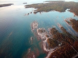
Lake Huron is one of the five
Great LakesThe Great Lakes are a collection of freshwater lakes located in northeastern North America, on the Canada – United States border. Consisting of Lakes Superior, Michigan, Huron, Erie, and Ontario, they form the largest group of freshwater lakes on Earth by total surface, coming in second by volume...
of
North AmericaNorth America is a continent wholly within the Northern Hemisphere and almost wholly within the Western Hemisphere. It is also considered a northern subcontinent of the Americas...
.
HydrologicallyHydrology is the study of the movement, distribution, and quality of water on Earth and other planets, including the hydrologic cycle, water resources and environmental watershed sustainability...
, it comprises the larger portion of
Lake Michigan-HuronLake Michigan-Huron is geologically the largest of the North American Great Lakes. Traditionally considered to be two separate lakes, Lake Michigan and Lake Huron, it is hydrologically a single body of water connected at the Straits of Mackinac....
. It is bounded on the east by the
CanadianCanada is a North American country consisting of ten provinces and three territories. Located in the northern part of the continent, it extends from the Atlantic Ocean in the east to the Pacific Ocean in the west, and northward into the Arctic Ocean...
province of
OntarioOntario is a province of Canada, located in east-central Canada. It is Canada's most populous province and second largest in total area. It is home to the nation's most populous city, Toronto, and the nation's capital, Ottawa....
and on the west by the state of
MichiganMichigan is a U.S. state located in the Great Lakes Region of the United States of America. The name Michigan is the French form of the Ojibwa word mishigamaa, meaning "large water" or "large lake"....
in the
United StatesThe United States of America is a federal constitutional republic comprising fifty states and a federal district...
. The name of the lake is derived from early French explorers who named it for the Huron people inhabiting the region.
Geography
Lake Huron is the second largest of the Great Lakes, with a surface area of 23,000 square miles (59,600 km
2) making it the third largest fresh water lake on Earth (fourth largest lake if the saline
Caspian SeaThe Caspian Sea is the largest enclosed body of water on Earth by area, variously classed as the world's largest lake or a full-fledged sea. The sea has a surface area of and a volume of...
is included). When measured at the Low Water Datum, the lake contains a volume of 850 cubic miles (3,540 km
3) and a shoreline length (including islands) of 3,827 miles (6,157 km).
The surface of Lake Huron is 577 feet (176 m) above
sea levelMean sea level is a measure of the average height of the ocean's surface ; used as a standard in reckoning land elevation...
. The lake's average depth is 195 feet (59 m), while the maximum depth is 750 feet (229 m). It has a length of 206 miles (331.5 km) and a greatest breadth of 183 miles (294.5 km).
Important cities on Lake Huron include:
GoderichGoderich is a town in the Canadian province of Ontario and is the county seat of Huron County. The town was founded by William "Tiger" Dunlop in 1827. First laid out in 1828, the town is named after Frederick John Robinson, 1st Viscount Goderich, who was British prime minister at the time. The town...
,
SarniaSarnia is a city in Southern Ontario, Canada . It is the largest city on Lake Huron and is located where the upper Great Lakes empty into the St. Clair River....
,
Bay CityBay City is a city in the U.S. state of Michigan located near the base of the Saginaw Bay on Lake Huron. As of the 2010 census, the city's population was 34,932, and is the principal city of the Bay City Metropolitan Statistical Area, which is included in the Saginaw-Bay City-Saginaw Township North...
,
AlpenaAlpena is a city in the U.S. state of Michigan and the county seat of Alpena County. It is considered to be part of Northern Michigan. The Thunder Bay National Marine Sanctuary is located in the city. The population was 10,483 at the 2010 census...
,
Rogers City-Commercial airports:The nearest commercial airports are Alpena County Regional Airport an Cherry Capital Airport -US Highway Business Loops:* BUS US 23-Intercounty Highways:* F-21-Demographics:...
,
CheboyganCheboygan is a city in the U.S. state of Michigan. As of the 2000 census, the city population was 5,295. It is the county seat of Cheboygan County....
,
St. IgnaceSaint Ignace, usually written as St. Ignace, is a city in the U.S. state of Michigan. As of the 2000 census, the city population was 2,678. It is the county seat of Mackinac County. From the Lower Peninsula, St. Ignace is the gateway to the Upper Peninsula.St...
, and
Port HuronPort Huron is a city in the U.S. state of Michigan and the county seat of St. Clair County. The population was 30,184 at the 2010 census. The city is adjacent to Port Huron Township but is administratively autonomous. It is joined by the Blue Water Bridge over the St. Clair River to Sarnia,...
.
A large bay that protrudes northeast from Lake Huron into Ontario, Canada is called
Georgian BayGeorgian Bay is a large bay of Lake Huron, located entirely within Ontario, Canada...
. A notable feature of the lake is
Manitoulin IslandManitoulin Island is a Canadian island in Lake Huron, in the province of Ontario. It is the largest island in a freshwater lake in the world. In addition to the historic Anishinaabe and European settlement of the island, archeological discoveries at Sheguiandah have demonstrated Paleo-Indian and...
, which separates the
North ChannelThe North Channel is the body of water along the north shore of Lake Huron, in the Canadian province of Ontario. It is bordered on the east by Georgian Bay, on the west by the St. Marys River, to the north by the eastern Algoma District and to the south by the islands of Manitoulin, Cockburn,...
and Georgian Bay from Lake Huron's main body of water. It is the world's largest freshwater
islandAn island or isle is any piece of sub-continental land that is surrounded by water. Very small islands such as emergent land features on atolls can be called islets, cays or keys. An island in a river or lake may be called an eyot , or holm...
.
A smaller bay that protrudes southwest from Lake Huron into the state of Michigan, U.S.A. is called
Saginaw BaySaginaw Bay is a bay within Lake Huron located on the eastern side of the U.S. state of Michigan. It forms the space between Michigan's Thumb region and the rest of the Lower Peninsula of Michigan. Saginaw Bay is in area...
.
Water Levels
Historic High Water
The lake fluctuates from month to month with the highest lake levels in October and November. The normal high water mark is 2 foot (0.6096 m) above datum (
577.5 ft or 176.0 m). In the summer of 1986, Lakes Michigan and Huron reached their highest level at 5.92 feet (1.8 m) above datum. The high water records began in February 1986 and lasted through the year, ending with January 1987. Water levels ranged from 3.67 to 5.92 ft (1.1 to 1.8 m) above Chart Datum.
Historic Low Water
Lake levels tend to be the lowest in winter. The normal low water mark is 1 feet (30.5 cm) below datum (
577.5 ft or 176.0 m). In the winter of 1964, Lakes Michigan and Huron reached their lowest level at 1.38 feet (42.1 cm) below datum. As with the high water records, monthly low water records were set each month from February 1964 through January 1965. During this twelve month period water levels ranged from 1.38 to 0.71 ft (42.1 to 21.6 cm) below Chart Datum.
Great Lakes Circle Tour
The
Great Lakes Circle TourThe Great Lakes Circle Tour is a designated scenic road system connecting all of the Great Lakes and the St. Lawrence River. It consists of routes for circumnavigating the lakes, either individually or collectively.-Lake Superior Circle Tour:...
is a designated scenic road system connecting all of the Great Lakes and the St. Lawrence River.
Geology
Lake Huron has the largest shore line length of any of the Great Lakes, counting its 30,000 islands.
Lake Huron is separated from
Lake MichiganLake Michigan is one of the five Great Lakes of North America and the only one located entirely within the United States. It is the second largest of the Great Lakes by volume and the third largest by surface area, after Lake Superior and Lake Huron...
, which lies at the same level, by the narrow
Straits of MackinacThe Straits of Mackinac is the strip of water that connects two of the Great Lakes, Lake Michigan and Lake Huron, and separates the Lower Peninsula of Michigan from the Upper Peninsula of Michigan. It is a shipping lane providing passage for raw materials and finished goods, connecting, for...
, making them geologically and hydrologically the same body of water (sometimes called
Lake Michigan-HuronLake Michigan-Huron is geologically the largest of the North American Great Lakes. Traditionally considered to be two separate lakes, Lake Michigan and Lake Huron, it is hydrologically a single body of water connected at the Straits of Mackinac....
and sometimes described as two 'lobes of the same lake'). Aggregated, Lake Huron-Michigan, at 45300 square miles (117,326.5 km²), "is technically the world's largest freshwater lake."
Lake SuperiorLake Superior is the largest of the five traditionally-demarcated Great Lakes of North America. It is bounded to the north by the Canadian province of Ontario and the U.S. state of Minnesota, and to the south by the U.S. states of Wisconsin and Michigan. It is the largest freshwater lake in the...
is slightly higher than both. It drains into the
St. Marys RiverThe St. Marys River , sometimes written as the St. Mary's River, drains Lake Superior, starting at the end of Whitefish Bay and flowing 74.5 miles southeast into Lake Huron, with a fall of ....
at
Sault Ste. MarieSault Ste. Marie may refer to:* Sault Ste. Marie, Ontario , a Canadian city** Sault Ste. Marie , a federal electoral district in Ontario, Canada...
which then flows southward into Lake Huron. The water then flows south to the
St. Clair RiverThe St. Clair River is a river in central North America which drains Lake Huron into Lake St Clair, forming part of the international boundary between the Canadian province of Ontario and the U.S. state of Michigan...
, at
Port Huron, MichiganPort Huron is a city in the U.S. state of Michigan and the county seat of St. Clair County. The population was 30,184 at the 2010 census. The city is adjacent to Port Huron Township but is administratively autonomous. It is joined by the Blue Water Bridge over the St. Clair River to Sarnia,...
and
Sarnia, OntarioSarnia is a city in Southern Ontario, Canada . It is the largest city on Lake Huron and is located where the upper Great Lakes empty into the St. Clair River....
.
The
Great Lakes WaterwayThe Great Lakes Waterway is a system of channels and canals that makes all of the Great Lakes accessible to oceangoing vessels. Its principal civil engineering components are the Welland Canal, bypassing Niagara Falls between Lake Ontario and Lake Erie, and the Soo Locks, bypassing the rapids of...
continues thence to Lake St. Clair; the
Detroit RiverThe Detroit River is a strait in the Great Lakes system. The name comes from the French Rivière du Détroit, which translates literally as "River of the Strait". The Detroit River has served an important role in the history of Detroit and is one of the busiest waterways in the world. The river...
and
Detroit, MichiganDetroit is the major city among the primary cultural, financial, and transportation centers in the Metro Detroit area, a region of 5.2 million people. As the seat of Wayne County, the city of Detroit is the largest city in the U.S. state of Michigan and serves as a major port on the Detroit River...
; into
Lake ErieLake Erie is the fourth largest lake of the five Great Lakes in North America, and the tenth largest globally. It is the southernmost, shallowest, and smallest by volume of the Great Lakes and therefore also has the shortest average water residence time. It is bounded on the north by the...
and thence – via
Lake OntarioLake Ontario is one of the five Great Lakes of North America. It is bounded on the north and southwest by the Canadian province of Ontario, and on the south by the American state of New York. Ontario, Canada's most populous province, was named for the lake. In the Wyandot language, ontarío means...
and the St. Lawrence River – to the Atlantic Ocean.
Like the other Great Lakes, it was formed by melting ice as the continental glaciers retreated toward the end of the last
ice ageAn ice age or, more precisely, glacial age, is a generic geological period of long-term reduction in the temperature of the Earth's surface and atmosphere, resulting in the presence or expansion of continental ice sheets, polar ice sheets and alpine glaciers...
. Before this, Lake Huron was a low-lying depression through which flowed the now-buried Laurentian and Huronian Rivers; the lake bed was criss-crossed by a large network of tributaries to these ancient waterways, with many of the old channels still evident on bathymetric maps.
History
The French, the first European visitors to the region, often referred to Lake Huron as La Mer Douce, "the fresh-water sea". In 1656, a map by French cartographer
Nicolas SansonNicolas Sanson was a French cartographer, wrongly termed by some the creator of French geography. He was born of an old Picardy family of Scottish descent, at Abbeville, on the 20th of December 1600, and was educated by the Jesuits at Amiens.In 1627 he attracted the attention of Richelieu by a...
, refers to the lake as Karegnondi, a Wendat word which has been variously translated as "Freshwater Sea", "Lake of the Hurons", or simply "lake".
The lake was generally labeled "Lac des Hurons" (Lake of the Huron) on most early European maps.
Storm of 1913
On November 9, 1913, a
great stormThe Great Lakes Storm of 1913, historically referred to as the "Big Blow", "Jeff Kinsland's Wash," the "Freshwater Fury" or the "White Hurricane", was a blizzard with hurricane-force winds that devastated the Great Lakes Basin in the Midwestern United States and the Canadian province of Ontario...
in Lake Huron sank ten ships and more than twenty were driven ashore. The storm, which raged for 16 hours, killed 235 seamen.
The Matoa had passed between
Port Huron, MichiganPort Huron is a city in the U.S. state of Michigan and the county seat of St. Clair County. The population was 30,184 at the 2010 census. The city is adjacent to Port Huron Township but is administratively autonomous. It is joined by the Blue Water Bridge over the St. Clair River to Sarnia,...
and
Sarnia, OntarioSarnia is a city in Southern Ontario, Canada . It is the largest city on Lake Huron and is located where the upper Great Lakes empty into the St. Clair River....
just after midnight. On the 9th, just after six in the morning, the Senator pushed upstream. Less than an hour later, the Manola passed through. Captain Frederick W. Light of the Manola reported that both the Canadian and the American weather stations had storm flag signals flying from their weather towers. Following behind at 7:00 a.m. that Sunday, the Regina steamed out of Sarnia into the northwest gale. The warnings now had been up for four hours. The Manola passed the Regina off Port Sanilac, 22 smi up the lake. Captain Light determined that if it continued to deteriorate, he would seek shelter at
Harbor Beach, MichiganHarbor Beach is a city in Huron County in the U.S. state of Michigan. The population was 1,837 at the 2000 census, with an estimated population of 1,587 in 2009.-Geography:...
, another 30 smi up the lake. There, he could seek shelter behind the breakwater. Before reaching Harbor Beach, the winds turned to the northeast and the lake began to rise. It would be noon before he reached Harbor Beach and ran for shelter. The waves were so violent that the Manola touched bottom entering the harbor. With help from a tug, the Manola tied up to the break wall with eight lines. It was about 3:00 p.m. when the Manola was secured and the crew prepared to drop anchor. As they worked, the cables began to snap from wind pressure against the hull. To keep from being pushed aground, they kept their bow into the wind with the engines running half to full in turns, yet the ship still drifted 800 feet (243.8 m) before its movement was arrested. Waves breaking over the ship damaged several windows and the crew reported seeing portions of the concrete break wall peeling off as the waves struck it.
Meanwhile, fifty miles further up the lake, the Matoa, and Captain Hugh McLeod had to ride out the storm without a safe harbor. The Matoa would be found stranded on the
Port AustinPort Austin is a village in Huron County in the U.S. state of Michigan. The population was 737 at the 2000 census. The village is within Port Austin Township.-Geography:...
reef when the winds subsided. It was noon on Monday before the winds let up and not until 11:00 p.m. that night before Capt. Light determined it to be safe to continue his journey.
Shipwrecks
More than a thousand wrecks have been recorded in Lake Huron. These purportedly include the first European vessel to sail the Great Lakes,
Le GriffonLe Griffon was a 17th century sailing ship built by René-Robert Cavelier, Sieur de La Salle in his quest to find the Northwest Passage to China and Japan....
built in 1679 on the eastern shore of
Lake ErieLake Erie is the fourth largest lake of the five Great Lakes in North America, and the tenth largest globally. It is the southernmost, shallowest, and smallest by volume of the Great Lakes and therefore also has the shortest average water residence time. It is bounded on the north by the...
, near
Buffalo, New YorkBuffalo is the second most populous city in the state of New York, after New York City. Located in Western New York on the eastern shores of Lake Erie and at the head of the Niagara River across from Fort Erie, Ontario, Buffalo is the seat of Erie County and the principal city of the...
, Sieur de la Salle navigated across Lake Erie, up the
Detroit RiverThe Detroit River is a strait in the Great Lakes system. The name comes from the French Rivière du Détroit, which translates literally as "River of the Strait". The Detroit River has served an important role in the history of Detroit and is one of the busiest waterways in the world. The river...
,
Lake St. ClairLake St. Clair is a fresh-water lake named after Clare of Assisi that lies between the Province of Ontario and the State of Michigan, and its midline also forms the boundary between Canada and the United States of America. Lake St. Clair includes the Anchor Bay along the Metro Detroit coastline...
and the
St. Clair RiverThe St. Clair River is a river in central North America which drains Lake Huron into Lake St Clair, forming part of the international boundary between the Canadian province of Ontario and the U.S. state of Michigan...
out into Lake Huron. Passing the
Straits of MackinacThe Straits of Mackinac is the strip of water that connects two of the Great Lakes, Lake Michigan and Lake Huron, and separates the Lower Peninsula of Michigan from the Upper Peninsula of Michigan. It is a shipping lane providing passage for raw materials and finished goods, connecting, for...
, La Salle and the
Griffon made landfall on
Washington IslandThe name Washington Island refers to:*Washington Island , the largest of the islands that make up the Town of Washington in Door County, Wisconsin*Washington Island in Keweenaw County, Michigan...
, off the tip of the
Door PeninsulaThe Door Peninsula is a peninsula in eastern Wisconsin, separating the southern part of the Green Bay from Lake Michigan. The peninsula begins in northern Brown and Kewaunee counties and proceeds northeast to include all of Door County. It is the western portion of the Niagara Escarpment. Well...
on the Wisconsin side of Lake Michigan. Here, La Salle filled the
Griffon with pelts and in late November 1679 sent the
Griffon back to the site of modern day Buffalo, never to be seen again.
Two wrecks have been identified as the
Griffon, although neither has gained final verification as the actual wreck. Blown by a fierce storm after leaving, the
Griffon ran aground before the storm. The people of
Manitoulin IslandManitoulin Island is a Canadian island in Lake Huron, in the province of Ontario. It is the largest island in a freshwater lake in the world. In addition to the historic Anishinaabe and European settlement of the island, archeological discoveries at Sheguiandah have demonstrated Paleo-Indian and...
say that the wreck in Mississagi Straits at the western tip of the island is that of the
Griffon. Meanwhile, others near
TobermoryTobermory is a small community located at the northern tip of the Bruce Peninsula in the municipality of Northern Bruce Peninsula, Ontario, Canada. It is 300 km northwest of Toronto...
say that the wreck on Russell Island, 150 miles further east in
Georgian BayGeorgian Bay is a large bay of Lake Huron, located entirely within Ontario, Canada...
is that of the Griffin.
Saginaw Bay
185 of 1,000+ wrecks are within the waters of
Saginaw BaySaginaw Bay is a bay within Lake Huron located on the eastern side of the U.S. state of Michigan. It forms the space between Michigan's Thumb region and the rest of the Lower Peninsula of Michigan. Saginaw Bay is in area...
.
Matoa, A propeller freighter, 2,311 gross tons, built 1890, Cleveland, wrecked,
1913, Port Austin Reef
Georgian Bay, North Channel
Georgian BayGeorgian Bay is a large bay of Lake Huron, located entirely within Ontario, Canada...
, which is the largest bay on Lake Huron, contains 212 of the 1,000 sunk vessels in the lake.
Manola, a propeller freighter of 2,325 gross tons. Built in 1890, by the Globe Shipping Company of
Cleveland, OhioCleveland is a city in the U.S. state of Ohio and is the county seat of Cuyahoga County, the most populous county in the state. The city is located in northeastern Ohio on the southern shore of Lake Erie, approximately west of the Pennsylvania border...
. Operated by the Minnesota Steamship Company (Cleveland) from 1890–1901, by the Pittsburgh Steamship Company from 1901–1918. On January 25, 1918, the Manola was sold to the U.S. Shipping Board. It was sold again in 1920 to the Canada Steamship Lines, Ltd and renamed the
Mapledawn. It became stranded on November 20, 1924 on Christian Island in Georgian Bay. It was headed for Port McNichol, Ontario. It was declared a total loss after two weeks. Salvagers were able to recover approximately 75,000 bushels of barley for delivery to
Midland, OntarioMidland is a town located on Georgian Bay in Simcoe County, Ontario, Canada.Situated at the southern end of Georgian Bay's 30,000 Islands, Midland is the economic centre of the region, with a 125-bed hospital and a local airport. It is the main town of the southern Georgian Bay area...
.
Ecology
Lake Huron has a
lake retention timeLake retention time is a calculated quantity expressing the mean time that water spends in a particular lake. At its simplest this figure is the result of dividing the lake volume by the flow in or out of the lake...
of 22 years.
Like all of the Great Lakes, the ecology of Lake Huron has undergone drastic changes in the last century. The lake originally supported a native deepwater fish community dominated by
lake troutLake trout is a freshwater char living mainly in lakes in northern North America. Other names for it include mackinaw, lake char , touladi, togue, and grey trout. In Lake Superior, they can also be variously known as siscowet, paperbellies and leans...
, which fed on a number of deepwater
ciscoThe ciscoes are salmonid fish of the genus Coregonus that differ from other members of the genus in having upper and lower jaws of approximately equal length and high gillraker counts...
s as well as sculpins and other native fishes. Several
invasive species"Invasive species", or invasive exotics, is a nomenclature term and categorization phrase used for flora and fauna, and for specific restoration-preservation processes in native habitats, with several definitions....
, including
sea lampreyThe sea lamprey is a parasitic lamprey found on the Atlantic coasts of Europe and North America, in the western Mediterranean Sea, and in the Great Lakes. It is brown, gray, or black on its back and white or gray on the underside and can grow up to 90 cm long. Sea lampreys prey on a wide...
,
alewifeThe alewife is a species of herring. There are anadromous and landlocked forms. The landlocked form is also called a sawbelly or mooneye...
and
rainbow smeltThe rainbow smelt, Osmerus mordax, is an anadromous species of fish of the family Osmeridae. The distribution of Osmerus mordax is circumpolar. The rainbow smelt was introduced to the Great Lakes, and from there has made its way to various other places. Walleye, trout, and other larger fish prey on...
, became abundant in the lake by the 1930s. The major native top predator, lake trout, were virtually extirpated from the lake by 1950 due to a combination of overfishing and the effects of sea lamprey. Several species of deepwater ciscos were also extirpated from the lake by the 1960s; the only remaining native deepwater cisco is the
bloaterThe bloater is a species of freshwater whitefish in the family Salmonidae. It is a silvery-coloured herring-like fish, long. It is found in most of the Great Lakes and in Lake Nipigon, where it inhabits underwater slopes....
. Nonnative Pacific salmon have been stocked in the lake since the 1960s, and lake trout have also been stocked in an attempt to rehabilitate the species, although little natural reproduction of stocked trout has been observed.
Lake Huron has suffered recently due the introduction of a variety of new invasive species, including
zebraThe zebra mussel, Dreissena polymorpha, is a small freshwater mussel. This species was originally native to the lakes of southeast Russia being first described in 1769 by a German zoologist Peter Simon Pallas in the Ural, Volga and Dnieper rivers. They are still found nearby, as Pontic and Caspian...
and
quagga musselThe quagga mussel is a subspecies of freshwater mussel, an aquatic bivalve mollusk.It is one of seven Dreissena species and has an average life span of 3 to 5 years....
s, the spiny water flea, and
round gobiesThe round goby, Neogobius melanostomus, is an euryhaline bottom-dwelling goby of the family Gobiidae, native to central Eurasia including the Black Sea and the Caspian Sea.-Characteristics:...
. The deepwater demersal fish community of the lake was in a state of collapse by 2006, and a number of drastic changes have been observed in the zooplankton community of the lake.
Chinook salmonThe Chinook salmon, Oncorhynchus tshawytscha, is the largest species in the pacific salmon family. Other commonly used names for the species include King salmon, Quinnat salmon, Spring salmon and Tyee salmon...
catches have also been greatly reduced in recent years, and
lake whitefishThe lake whitefish , also called the Sault whitefish or gizzard fish, is a species of freshwater whitefish from North America. Lake whitefish are found throughout much of Canada and parts of the northern United States, including all of the Great Lakes. A valuable commercial fish, they are also...
have become less abundant and are in poor condition. These recent changes may be attributable to the new exotic species.
See also
- Drummond Island
- Georgian Bay
Georgian Bay is a large bay of Lake Huron, located entirely within Ontario, Canada...
- Hurricane Huron
- Les Cheneaux Islands
Les Cheneaux Islands are a group of 36 small islands, some inhabited, along 12 miles of Lake Huron shoreline on the southeastern tip of the Upper Peninsula of Michigan in the United States. The name is French for "the Channels", noting the many channels between the islands in the group...
- Mackinac Island
Mackinac Island is an island and resort area covering in land area, part of the U.S. state of Michigan. It is located in Lake Huron, at the eastern end of the Straits of Mackinac, between the state's Upper and Lower Peninsulas. The island was home to a Native American settlement before European...
- Michigan lighthouses
- Saginaw Bay
Saginaw Bay is a bay within Lake Huron located on the eastern side of the U.S. state of Michigan. It forms the space between Michigan's Thumb region and the rest of the Lower Peninsula of Michigan. Saginaw Bay is in area...
- Sauble Beach
- Shipwrecks of the 1913 Great Lakes storm
This is a list of shipwrecks during the Great Lakes Storm of 1913.-References:*Brown, David G. . White Hurricane. International Marine / McGraw-Hill. ISBN 0-07-138037-X.*-External links:***...
and List of victims of the 1913 Great Lakes storm
- Thunder Bay
Thunder Bay is a bay in the U.S. state of Michigan on Lake Huron. The bay extends from North Point at to South Point at .The city of Alpena lies at the mouth of the Thunder Bay River at...
- Wasaga Beach
External links
Lighthouses