

Thames Barrier
Encyclopedia
Flood barrier
A flood barrier, surge barrier of storm surge barrier is a specific type of floodgate, designed to prevent a storm surge or spring tide from flooding the protected area behind the barrier...
(after the Oosterscheldekering
Oosterscheldekering
The Oosterscheldekering , between the islands Schouwen-Duiveland and Noord-Beveland, is the largest of the 13 ambitious Delta works series of dams, designed to protect the Netherlands from flooding...
in the Netherlands
Netherlands
The Netherlands is a constituent country of the Kingdom of the Netherlands, located mainly in North-West Europe and with several islands in the Caribbean. Mainland Netherlands borders the North Sea to the north and west, Belgium to the south, and Germany to the east, and shares maritime borders...
) and is located downstream of central London. Its purpose is to prevent London from being flooded by exceptionally high tide
Tide
Tides are the rise and fall of sea levels caused by the combined effects of the gravitational forces exerted by the moon and the sun and the rotation of the Earth....
s and storm surge
Storm surge
A storm surge is an offshore rise of water associated with a low pressure weather system, typically tropical cyclones and strong extratropical cyclones. Storm surges are caused primarily by high winds pushing on the ocean's surface. The wind causes the water to pile up higher than the ordinary sea...
s moving up from the sea. It needs to be raised (closed) only during high tide; at ebb tide it can be lowered to release the water that backs up behind it. Its northern bank is in Silvertown
Silvertown
Silvertown is an industrialised district on the north bank of the Thames in the London Borough of Newham. It was named after Samuel Winkworth Silver's former rubber factory which opened in 1852, and is now dominated by the Tate & Lyle sugar refinery and the John Knight ABP animal rendering...
in the London Borough of Newham
London Borough of Newham
The London Borough of Newham is a London borough formed from the towns of West Ham and East Ham, within East London.It is situated east of the City of London, and is north of the River Thames. According to 2006 estimates, Newham has one of the highest ethnic minority populations of all the...
and its southern bank is in the New Charlton
New Charlton
New Charlton is the area along the south bank of the River Thames at Charlton, London, and forms part of the London Borough of Greenwich. It was historically primarily an industrial zone.-History:...
area of Charlton
Charlton, London
Charlton is a district of south London, England, and part of the London Borough of Greenwich. It is located east-southeast of Charing Cross. Charlton next Woolwich was an ancient parish in the county of Kent, which became part of the metropolitan area of London in 1855. It is home to Charlton...
in the London Borough of Greenwich
London Borough of Greenwich
The London Borough of Greenwich is an Inner London borough in south-east London, England. Taking its name from the historic town of Greenwich, the present borough was formed in 1965 by the amalgamation of the former area of the Metropolitan Borough of Greenwich with part of the Metropolitan...
. The report of Sir Hermann Bondi
Hermann Bondi
Sir Hermann Bondi, KCB, FRS was an Anglo-Austrian mathematician and cosmologist. He is best known for developing the steady-state theory of the universe with Fred Hoyle and Thomas Gold as an alternative to the Big Bang theory, but his most lasting legacy will probably be his important...
into the North Sea flood of 1953
North Sea flood of 1953
The 1953 North Sea flood was a major flood caused by a heavy storm, that occurred on the night of Saturday 31 January 1953 and morning of 1 February 1953. The floods struck the Netherlands, Belgium, England and Scotland.A combination of a high spring tide and a severe European windstorm caused a...
affecting parts of the Thames Estuary and parts of London was instrumental in the building of the barrier.
Geographical weather system
London is vulnerable to flooding. A storm surge generated by low pressure in the Atlantic OceanAtlantic Ocean
The Atlantic Ocean is the second-largest of the world's oceanic divisions. With a total area of about , it covers approximately 20% of the Earth's surface and about 26% of its water surface area...
sometimes tracks eastwards past the north of Scotland and may then be driven into the shallow waters of the North Sea
North Sea
In the southwest, beyond the Straits of Dover, the North Sea becomes the English Channel connecting to the Atlantic Ocean. In the east, it connects to the Baltic Sea via the Skagerrak and Kattegat, narrow straits that separate Denmark from Norway and Sweden respectively...
. The surge tide is funnelled down the North Sea which narrows towards the English Channel
English Channel
The English Channel , often referred to simply as the Channel, is an arm of the Atlantic Ocean that separates southern England from northern France, and joins the North Sea to the Atlantic. It is about long and varies in width from at its widest to in the Strait of Dover...
and the Thames Estuary. If the storm surge coincides with a spring tide, dangerously high water levels can occur in the Thames Estuary. This situation combined with downstream flows in the Thames provides the triggers for flood defence operations.
Rising water levels
The threat has increased over time due to the slow but continuous rise in high water level over the centuries (20 cm (8 inches) / 100 years) and the slow "tilting" of Britain (up in the north and west, and down in the south and east) caused by post-glacial reboundPost-glacial rebound
Post-glacial rebound is the rise of land masses that were depressed by the huge weight of ice sheets during the last glacial period, through a process known as isostasy...
.
Historical flooding
Fourteen people died in the 1928 Thames flood1928 Thames flood
The 1928 Thames flood was a disastrous flood of the River Thames that affected much of riverside London on 7 January 1928, as well as places further downriver. Fourteen people were drowned in London and thousands were made homeless when flood waters poured over the top of the Thames Embankment and...
, and after 307 people died in the UK in the North Sea Flood of 1953
North Sea flood of 1953
The 1953 North Sea flood was a major flood caused by a heavy storm, that occurred on the night of Saturday 31 January 1953 and morning of 1 February 1953. The floods struck the Netherlands, Belgium, England and Scotland.A combination of a high spring tide and a severe European windstorm caused a...
the issue gained new prominence.
Early proposals for a flood control system were stymied by the need for a large opening in the barrier to allow for vessels from London Docks to pass through. When containerization
Containerization
Containerization is a system of freight transport based on a range of steel intermodal containers...
replaced older forms of shipping and a new port was opened at Tilbury
Tilbury
Tilbury is a town in the borough of Thurrock, Essex, England. As a settlement it is of relatively recent existence, although it has important historical connections, being the location of a 16th century fort and an ancient cross-river ferry...
, a smaller barrier became feasible with each of the four main navigation spans being the same width as the opening of Tower Bridge
Tower Bridge
Tower Bridge is a combined bascule and suspension bridge in London, England, over the River Thames. It is close to the Tower of London, from which it takes its name...
.
Design and construction
The concept of the rotating gates was devised by Charles DraperCharles Stark Draper
Charles Stark Draper was an American scientist and engineer, often referred to as "the father of inertial navigation." He was the founder and director of the MIT Instrumentation Laboratory, later renamed the Charles Stark Draper Laboratory, which under his direction designed and built the Apollo...
. The barrier was designed by Rendel, Palmer and Tritton for the Greater London Council
Greater London Council
The Greater London Council was the top-tier local government administrative body for Greater London from 1965 to 1986. It replaced the earlier London County Council which had covered a much smaller area...
and tested at the Hydraulics Research Station
Hydraulics Research Station
The Hydraulics Research Station was created by the UK Department of Scientific and Industrial Research in 1947. The Research Station was based in Wallingford, near Oxford. It was established to deal with “looser boundary” problems such as coastal erosion, flood protection and the silting and...
, Wallingford. The site at New Charlton was chosen because of the relative straightness of the banks, and because the underlying river chalk was strong enough to support the barrier. Work began at the barrier site in 1974 and construction, which had been undertaken by a Costain
Costain Group
Costain Group plc is a British construction and civil engineering company headquartered in Maidenhead. It was part of the original Channel Tunnel consortium and is involved in Private Finance Initiative projects.-History:...
/Hollandsche Beton Maatschappij/Tarmac Construction consortium, was largely complete by 1982. In addition to the barrier itself the flood defences for 11 miles down river were raised and strengthened. The barrier was officially opened on 8 May 1984 by Her Majesty Queen Elizabeth II. Total construction cost was around £534 m (£1.3 billion at 2001 prices) with an additional £100 m for river defences.
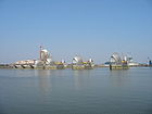
Built across a 520 metres (568.7 yd) wide stretch of the river, the barrier divides the river into four 61 metres (200.1 ft) and two about 30 metre (100 ft) navigable spans. There are also four smaller non-navigable channels between nine concrete piers and two abutments. The flood gates across the openings are circular segment
Circular segment
In geometry, a circular segment is an area of a circle informally defined as an area which is "cut off" from the rest of the circle by a secant or a chord. The circle segment constitutes the part between the secant and an arc, excluding the circle's center...
s in cross section, and they operate by rotating, raised to allow "underspill" to allow operators to control upstream levels and a complete 180 degree rotation for maintenance. All the gates are hollow and made of steel up to 40 millimetres (1.6 in) thick. The gates fill with water when submerged and empty as they emerge from the river. The four large central gates are 20.1 metres (65.9 ft) high and weigh 3,700 tonne
Tonne
The tonne, known as the metric ton in the US , often put pleonastically as "metric tonne" to avoid confusion with ton, is a metric system unit of mass equal to 1000 kilograms. The tonne is not an International System of Units unit, but is accepted for use with the SI...
s. Four radial gates by the riverbanks, also about 30 metres (100 ft) wide, can be lowered. These gate openings, unlike the main six, are non-navigable.
Prediction for operation
A Thames Barrier flood defence closure is triggered when a combination of high tides forecast in the North Sea and high river flows at the tidal limit at Teddington weirTeddington Lock
Teddington Lock is a complex of three locks and a weir on the River Thames in England at Ham in the western suburbs of London. The lock is on the southern Surrey side of the river....
indicate that water levels would exceed 4.87 metres (16 ft) in central London. Forecast sea levels at the mouth of the Thames Estuary are generated by Met Office
Met Office
The Met Office , is the United Kingdom's national weather service, and a trading fund of the Department for Business, Innovation and Skills...
computers and also by models run on the Thames Barrier's own forecasting
Forecasting
Forecasting is the process of making statements about events whose actual outcomes have not yet been observed. A commonplace example might be estimation for some variable of interest at some specified future date. Prediction is a similar, but more general term...
and telemetry
Telemetry
Telemetry is a technology that allows measurements to be made at a distance, usually via radio wave transmission and reception of the information. The word is derived from Greek roots: tele = remote, and metron = measure...
computer systems. About 9 hours before the high tide
Tide
Tides are the rise and fall of sea levels caused by the combined effects of the gravitational forces exerted by the moon and the sun and the rotation of the Earth....
reaches the barrier a flood defence closure begins with messages to stop river traffic, close subsidiary gates and alert other river users. As well as the Thames Barrier, the smaller gates along the Thames Tideway include Barking Barrier, King George V Lock gate, Dartford Barrier and gates at Tilbury Docks and Canvey Island must also be closed. Once river navigation has been stopped and all subsidiary gates closed, then the Thames Barrier itself can be closed. The smaller gates are closed first, then the main navigable spans in succession. The gates remain closed until the tide downstream of the barrier falls to the same level as the water level upstream.
After periods of heavy rain west of London, floodwater can also flow down the Thames upstream from London. Because the river is tidal from Teddington weir all the way through London, this is only a problem at high tide, which prevents the floodwater from escaping out to sea. From Teddington the river is opening out into its estuary, and at low tide it can take much greater flow rates the further one goes downstream. In periods when the river is in flood upstream, if the gates are closed shortly after low tide, a huge empty volume is created behind the barrier which can act as a reservoir to hold the floodwater coming over Teddington weir. Most river floods will not fill this volume in the few hours of the high tide cycle during which the barrier needs to be closed. If the barrier was not there, the high tide would fill up this volume instead, and the floodwater could then spill over the river banks in London. About a third of the closures up to 2009 were to alleviate fluvial flooding.
Barrier closures and incidents
In the 1980s there were four closures, 35 closures in the 1990s, and 75 closures in the first decade of this century.An incident that was potentially catastrophic for London occurred on 27 October 1997. The dredger MV Sand Kite sailing in thick fog, collided with one of the Thames Barrier's piers. As the ship started to sink she dumped her 3,300 tonne load of aggregate, finally sinking by the bow on top of one of the barrier's gates where she lay for several days. Initially the gate could not be closed as it was covered in a thick layer of gravel. A longer term problem was the premature loss of paint on the flat side of the gate caused by abrasion. One estimate of the cost of flooding damage, had it occurred, was around £13 billion. The vessel was refloated in mid-November 1997.
The barrier was closed twice on 9 November 2007 after a storm surge in the North Sea which was compared to the one in 1953. The main danger of flooding from the surge was on the coast above the Thames Barrier, where evacuations took place, but the winds abated a little and, at the Thames Barrier, the 9 November 2007 storm surge did not completely coincide with high tide.
Ownership / operating authority
The barrier was originally commissioned by the Greater London CouncilGreater London Council
The Greater London Council was the top-tier local government administrative body for Greater London from 1965 to 1986. It replaced the earlier London County Council which had covered a much smaller area...
under the guidance of Ray Horner. After the 1986 abolition of the GLC it was operated successively by Thames Water
Thames Water
Thames Water Utilities Ltd, known as Thames Water, is the private utility company responsible for the public water supply and waste water treatment in large parts of Greater London, the Thames Valley, Surrey, Gloucestershire, Wiltshire, Kent, and some other areas of in the United Kingdom...
Authority and then the National Rivers Authority
National Rivers Authority
The National Rivers Authority was one of the forerunners of the Environment Agency of England and Wales, existing between 1989 and 1996. Before 1989 the regulation of the aquatic environment had largely been carried out by the ten Regional Water Authorities...
until April 1996 when it passed to the Environment Agency
Environment Agency
The Environment Agency is a British non-departmental public body of the Department for Environment, Food and Rural Affairs and an Assembly Government Sponsored Body of the Welsh Assembly Government that serves England and Wales.-Purpose:...
.
Future
The barrier was originally designed to protect London against a big flood level, with a return periodReturn period
A return period also known as a recurrence interval is an estimate of the interval of time between events like an earthquake, flood or river discharge flow of a certain intensity or size. It is a statistical measurement denoting the average recurrence interval over an extended period of time, and...
of one-thousand years up to the year 2030, after which the protection would decrease, whilst remaining within acceptable limits.
This defence level included long-term changes in sea and land levels as understood at that time (c. 1970). Despite global warming and a consequently greater predicted rate of sea level rise recent analysis extended the working life of the barrier until around 2060–2070. From 1982 until 19 March 2007, the barrier was raised one-hundred times to prevent flooding. It is also raised monthly for testing.
Released in 2005, a study by four respected academics contained a proposal to supersede the Thames Barrier by a more ambitious 16 km (10 mi) long barrier across the Thames Estuary from Sheerness
Sheerness
Sheerness is a town located beside the mouth of the River Medway on the northwest corner of the Isle of Sheppey in north Kent, England. With a population of 12,000 it is the largest town on the island....
in Kent
Kent
Kent is a county in southeast England, and is one of the home counties. It borders East Sussex, Surrey and Greater London and has a defined boundary with Essex in the middle of the Thames Estuary. The ceremonial county boundaries of Kent include the shire county of Kent and the unitary borough of...
to Southend
Southend-on-Sea
Southend-on-Sea is a unitary authority area, town, and seaside resort in Essex, England. The district has Borough status, and comprises the towns of Chalkwell, Eastwood, Leigh-on-Sea, North Shoebury, Prittlewell, Shoeburyness, Southchurch, Thorpe Bay, and Westcliff-on-Sea. The district is situated...
in Essex
Essex
Essex is a ceremonial and non-metropolitan county in the East region of England, and one of the home counties. It is located to the northeast of Greater London. It borders with Cambridgeshire and Suffolk to the north, Hertfordshire to the west, Kent to the South and London to the south west...
.
In November 2011 a new Thames Barrier, further downsteam at Lower Hope between East Tilbury
East Tilbury
East Tilbury is a village in the unitary authority of Thurrock borough, England and one of the traditional parishes in Thurrock.-History:In Saxon times, the location on which the church now stands was surrounded by tidal marshland...
in Essex and Cliffe
Cliffe
Cliffe could be*Cliffe, Kent, Kent*Cliffe, Richmondshire, North Yorkshire*Cliffe, Selby, North Yorkshire*Jess Cliffe , Valve Software*The Cliffe a residence in Peppermint Grove, Western Australia...
in Kent, was proposed as part of the Thames Hub
Thames Hub
The Thames Hub is a proposal for a new approach to integrated infrastructure development that combines rail, freight logistics, aviation, renewable energy and its transmission, flood protection and regional development in the Thames Estuary and connects this infrastructure to a trade and utilities...
integrated infrastructure development. The barrier would incorporate hydropower
Tidal power
Tidal power, also called tidal energy, is a form of hydropower that converts the energy of tides into useful forms of power - mainly electricity....
turbines to generate renewable energy and include road and rail tunnels, providing connections from Essex to a major new hub airport on the Isle of Grain
Isle of Grain
The Isle of Grain, in the north of Kent, England, is the easternmost point of the Hoo Peninsula. No longer an island, the Isle is almost all marshland and the Grain Marshes are an important habitat for birdlife...
.
See also
- Thames Barrier ParkThames Barrier ParkThe Thames Barrier Park is a park in London's docklands, named after its location on the north side of the River Thames next to the Thames Barrier. It is intended to aid the regeneration of the area by creating an attractive public space alongside residential and commercial developments...
- Floodgates
- OosterscheldekeringOosterscheldekeringThe Oosterscheldekering , between the islands Schouwen-Duiveland and Noord-Beveland, is the largest of the 13 ambitious Delta works series of dams, designed to protect the Netherlands from flooding...
, part of the Delta WorksDelta WorksThe Delta Works is a series of construction projects in the southwest of the Netherlands to protect a large area of land around the Rhine-Meuse-Scheldt delta from the sea. The works consist of dams, sluices, locks, dikes, levees, and storm surge barriers... - FloodFloodA flood is an overflow of an expanse of water that submerges land. The EU Floods directive defines a flood as a temporary covering by water of land not normally covered by water...
- Flood controlFlood controlIn communications, flood control is a feature of many communication protocols designed to prevent overwhelming of a destination receiver. Such controls can be implemented either in software or in hardware, and will often request that the message be resent after the receiver has finished...
- Port of London AuthorityPort of London AuthorityThe Port of London Authority is a self-funding public trust established in 1908 by the Port of London Act to govern the Port of London. Its responsibility extends over the Tideway of the River Thames and the authority is responsible for the public right of navigation and for conservancy of the...
- Barrier Gardens PierBarrier Gardens PierBarrier Gardens Pier is a pier on the River Thames near the Thames Barrier. It is owned and managed by the Port of London Authority which took over the pier and adjoining Unity House from the Environment Agency and Sargent Brothers in 2009....
- Environment AgencyEnvironment AgencyThe Environment Agency is a British non-departmental public body of the Department for Environment, Food and Rural Affairs and an Assembly Government Sponsored Body of the Welsh Assembly Government that serves England and Wales.-Purpose:...
- River ThamesRiver ThamesThe River Thames flows through southern England. It is the longest river entirely in England and the second longest in the United Kingdom. While it is best known because its lower reaches flow through central London, the river flows alongside several other towns and cities, including Oxford,...
- MOSE ProjectMOSE ProjectThe MOSE Project is a project intended to protect the city of Venice, Italy from floods...
Further reading
- The Thames Barrier. S Gilbert. Thomas Telford Ltd. 30 June 1986. 216 pages. ISBN 0-727-70249-1.
- The Story of the Thames Barrier. Ken Wilson. Lanthorn. 1984. 32 pages. ISBN 0-947-98705-3.
External links
- Thames Barrier page at the Environment Agency
- Animation showing how the Barrier works
- Streetmap of Thames Barrier
- Thames Barrier Information and Learning Centre - on south side of the Thames
- Thames Barrier Park - park by the Barrier on north side of the Thames