

Pennsylvania Route 113
Encyclopedia
Pennsylvania Route 113 is a 46 miles (74 km) long state route in eastern Pennsylvania
. The southern terminus of the route is at U.S. Route 30 Business in Downingtown
. Its northern terminus is at Pennsylvania Route 611
in Tinicum Township
. The route is signed as north–south although its exact alignment follows a northeast-southwest routing.
 PA 113 begins as West Uwchlan Avenue at US 30 Business / Lancaster Avenue in Downingtown
. Northeast of US 30 BUS, PA 113 is carried over the U.S. Route 30 Bypass
, with only partial access to the Bypass. As Uwchlan Ave, PA 113 runs northeast and in Uwchlan Township
, PA 113 meets Pennsylvania Route 100
near the village of Lionville. Northeast of PA 100, PA 113 passes over Interstate 76
(the Pennsylvania Turnpike
). In West Pikeland Township
, PA 113 is called Pike Springs Road and meets Pennsylvania Route 401
at a crossroads called Opperman's Corner. As PA 113 enters Schuylkill Township
it is called Kimberton Road; it was slightly re-routed in the 1970s when a bypass was constructed around Kimberton
. (The historic roadbed is currently Kimberton Road and Hares Hill Road.)
In Phoenixville
, PA 113 runs concurrently with Pennsylvania Route 23
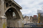
. After the concurrency, PA 113 is called Bridge Street, then turns and is called Gay Street. The Gay Street Bridge passes over the former Phoenix Iron Works
site and French Creek
. PA 113 is then named Franklin Avenue, Emmett Street and Dayton Street as it winds through the north side of Phoenixville. Before leaving Chester County
, PA 113 is called Black Rock Road.
, PA 113 is called S. Trappe Road and passes under U.S. Route 422
. In Trappe
, PA 113 intersects Main Street (part of Ridge Pike, which is a thoroughfare connecting Pottstown, Pennsylvania
, with Philadelphia). Northeast of Trappe, PA 113 is known as Bridge Road and intersects Pennsylvania Route 29
. In Skippack Township
, PA 113 intersects with Pennsylvania Route 73
. In Lower Salford Township
, PA 113 is known as Harleysville Pike. In Harleysville
, PA 113 intersects with Pennsylvania Route 63
. In Franconia Township
, PA 113 passes over Interstate 476
(the Pennsylvania Turnpike
). In Souderton
, PA 113 is called Main Street as it enters the town. Then it turns to the northeast as Broad Street before crossing County Line Road.
and PA 113 also interchanges with Pennsylvania Route 309
. North of PA 309, PA 113 is called Souderton Road. In Silverdale
, PA 113 forms a wrong-way concurrency with Pennsylvania Route 152
. On the township line in Kulps Corner PA 113 intersects with Pennsylvania Route 313
. About 8 miles (12.9 km) north of Kulps Corner, PA 113 terminates (ends) at an intersection with Pennsylvania Route 611
as Bedminster Road.
. In 1946, the northern terminus was moved from U.S. Route 13 in Eddington to its current location.
brewed by the Sly Fox Brewing Company, which operates a brewpub along 113, just west of Phoenixville.
Pennsylvania
The Commonwealth of Pennsylvania is a U.S. state that is located in the Northeastern and Mid-Atlantic regions of the United States. The state borders Delaware and Maryland to the south, West Virginia to the southwest, Ohio to the west, New York and Ontario, Canada, to the north, and New Jersey to...
. The southern terminus of the route is at U.S. Route 30 Business in Downingtown
Downingtown, Pennsylvania
Downingtown is a borough in Chester County, Pennsylvania, west of Philadelphia. As of the 2010 census it had a population of 7,891. Downingtown was settled by English and European colonists in the early 18th century and has a number of historic buildings and structures.-History:The town was...
. Its northern terminus is at Pennsylvania Route 611
Pennsylvania Route 611
Pennsylvania Route 611 is a major state highway in Pennsylvania, United States, running from Interstate 95 south of downtown Philadelphia north to Interstate 380 in Coolbaugh Township, Pennsylvania in The Poconos....
in Tinicum Township
Tinicum Township, Bucks County, Pennsylvania
Tinicum Township is a township in Bucks County, Pennsylvania, United States. The population was 3,995 at the 2010 census.The Uhlerstown-Frenchtown Bridge, a free Delaware River Joint Toll Bridge Commission bridge over the Delaware River, connects Uhlerstown to Frenchtown in Hunterdon County, New...
. The route is signed as north–south although its exact alignment follows a northeast-southwest routing.
Chester County
Downingtown, Pennsylvania
Downingtown is a borough in Chester County, Pennsylvania, west of Philadelphia. As of the 2010 census it had a population of 7,891. Downingtown was settled by English and European colonists in the early 18th century and has a number of historic buildings and structures.-History:The town was...
. Northeast of US 30 BUS, PA 113 is carried over the U.S. Route 30 Bypass
U.S. Route 30
U.S. Route 30 is an east–west main route of the system of United States Numbered Highways, with the highway traveling across the northern tier of the country. It is the third longest U.S. route, after U.S. Route 20 and U.S. Route 6. The western end of the highway is at Astoria, Oregon; the...
, with only partial access to the Bypass. As Uwchlan Ave, PA 113 runs northeast and in Uwchlan Township
Uwchlan Township, Pennsylvania
Uwchlan Township is a township in Chester County, Pennsylvania, United States. The population was 18,088 at the 2010 census.-Geography:Uwchlan Township is located at at an elevation of . According to the United States Census Bureau, the township has a total area of , all of it land.-Adjacent...
, PA 113 meets Pennsylvania Route 100
Pennsylvania Route 100
Pennsylvania Route 100 is a state highway in the U.S. state of Pennsylvania that runs from U.S. Route 202 in West Chester, Pennsylvania to Pennsylvania Route 309 in Pleasant Corners, Pennsylvania....
near the village of Lionville. Northeast of PA 100, PA 113 passes over Interstate 76
Interstate 76 (east)
Interstate 76 is an Interstate Highway in the United States, running 435 miles from an interchange with Interstate 71 west of Akron, Ohio, east to Interstate 295 near Camden, New Jersey....
(the Pennsylvania Turnpike
Pennsylvania Turnpike
The Pennsylvania Turnpike is a toll highway system operated by the Pennsylvania Turnpike Commission in the Commonwealth of Pennsylvania, United States. The three sections of the turnpike system total . The main section extends from Ohio to New Jersey and is long...
). In West Pikeland Township
West Pikeland Township, Pennsylvania
West Pikeland Township is a township in Chester County, Pennsylvania, United States. The population was 4,024 at the 2010 census.-Geography:According to the United States Census Bureau, the township has a total area of , of which , or 0.20%, is water....
, PA 113 is called Pike Springs Road and meets Pennsylvania Route 401
Pennsylvania Route 401
Pennsylvania Route 401 is a short east–west state route in Berks and Chester counties, located in southeast Pennsylvania. The western terminus is at Pennsylvania Route 23 in Caernarvon Township, across the county line from Elverson. The eastern terminus is at U.S...
at a crossroads called Opperman's Corner. As PA 113 enters Schuylkill Township
Schuylkill Township, Chester County, Pennsylvania
Schuylkill Township is a township in Chester County, Pennsylvania, United States. It contains the village of Valley Forge. The population was 8,516 at the 2010 census....
it is called Kimberton Road; it was slightly re-routed in the 1970s when a bypass was constructed around Kimberton
Kimberton, Pennsylvania
Kimberton is an unincorporated community in East Pikeland Township in Chester County, Pennsylvania, United States. The zip code is 19442. Originally settled in the late 18th century, it was not named until 1817. Like many surrounding villages, Kimberton developed around a tavern; in this case, the...
. (The historic roadbed is currently Kimberton Road and Hares Hill Road.)
In Phoenixville
Phoenixville, Pennsylvania
Phoenixville is a borough in Chester County, Pennsylvania, United States, northwest of Philadelphia, at the junction of French Creek with the Schuylkill River. The population is 16,440 as of the 2010 Census.- History :...
, PA 113 runs concurrently with Pennsylvania Route 23
Pennsylvania Route 23
Pennsylvania Route 23 is a state highway in southeastern Pennsylvania. The route begins at Pennsylvania Route 441 in Marietta and heads east to U.S. Route 1 in Philadelphia.-Marietta to Valley Forge:...
. After the concurrency, PA 113 is called Bridge Street, then turns and is called Gay Street. The Gay Street Bridge passes over the former Phoenix Iron Works
Phoenix Iron Works
The Phoenix Iron Works , located in Phoenixville, Pennsylvania, was a significant manufacturer of iron and related products during the 19th century and early 20th century. Phoenix Iron Company was a major producer of cannons for the Union Army during the American Civil War...
site and French Creek
French Creek (Schuylkill River)
French Creek, once known as Saukanac Creek, is a tributary of the Schuylkill River in Berks and Chester counties, Pennsylvania in the United States.French Creek travels through French Creek State Park and joins the Schuylkill in Phoenixville...
. PA 113 is then named Franklin Avenue, Emmett Street and Dayton Street as it winds through the north side of Phoenixville. Before leaving Chester County
Chester County, Pennsylvania
-State parks:*French Creek State Park*Marsh Creek State Park*White Clay Creek Preserve-Demographics:As of the 2010 census, the county was 85.5% White, 6.1% Black or African American, 0.2% Native American or Alaskan Native, 3.9% Asian, 0.0% Native Hawaiian, 1.8% were two or more races, and 2.4% were...
, PA 113 is called Black Rock Road.
Montgomery County
After crossing the Schuylkill RiverSchuylkill River
The Schuylkill River is a river in Pennsylvania. It is a designated Pennsylvania Scenic River.The river is about long. Its watershed of about lies entirely within the state of Pennsylvania. The source of its eastern branch is in the Appalachian Mountains at Tuscarora Springs, near Tamaqua in...
, PA 113 is called S. Trappe Road and passes under U.S. Route 422
U.S. Route 422
U.S. Route 422 is a long spur route of US 22 split into two segments in the U.S. states of Ohio and Pennsylvania. The western spur begins in downtown Cleveland, Ohio, and ends at Ebensburg, Pennsylvania...
. In Trappe
Trappe, Pennsylvania
Trappe is a borough in Montgomery County, Pennsylvania, United States. The population was 3,509 at the 2010 census. Augustus Lutheran Church, built in 1743, is the oldest unchanged Lutheran church building in the United States in continuous use by the same congregation...
, PA 113 intersects Main Street (part of Ridge Pike, which is a thoroughfare connecting Pottstown, Pennsylvania
Pottstown
Pottstown is the name of some places in the United States of America:*Pottstown, Illinois*Pottstown, Pennsylvania...
, with Philadelphia). Northeast of Trappe, PA 113 is known as Bridge Road and intersects Pennsylvania Route 29
Pennsylvania Route 29
Pennsylvania Route 29 is a 118 mile long north–south state highway that runs through most of eastern Pennsylvania. The route currently exists in two segments, a southern segment and a northern segment. The southernmost terminus of the designation is at U.S. Route 30 in Malvern...
. In Skippack Township
Skippack Township, Pennsylvania
Skippack Township is a township in Montgomery County, Pennsylvania, United States. The population was 13,715 at the 2010 census. This represents a 110.5% increase from the 2000 count of 6,516 residents.-Geography:...
, PA 113 intersects with Pennsylvania Route 73
Pennsylvania Route 73
Pennsylvania Route 73 is a 62.51 miles long east–west state highway in southeastern Pennsylvania. It runs from Pennsylvania Route 61 in Leesport to the New Jersey state line on the Tacony-Palmyra Bridge in Philadelphia, where it continues as New Jersey Route 73.Predating the Interstate...
. In Lower Salford Township
Lower Salford Township, Pennsylvania
Lower Salford Township is a township in Montgomery County, Pennsylvania, United States. The population was 14,959 at the 2010 census.-Geography:...
, PA 113 is known as Harleysville Pike. In Harleysville
Harleysville, Pennsylvania
Harleysville is a census-designated place in Montgomery County, Pennsylvania, United States. The population was 9,286 at the 2010 census. It is located within Lower Salford Township...
, PA 113 intersects with Pennsylvania Route 63
Pennsylvania Route 63
Pennsylvania Route 63 is a long state highway located in the Philadelphia, Pennsylvania area. The western terminus of the route is at PA 29 in Green Lane, Montgomery County. The eastern terminus is at Interstate 95 in Bensalem Township, Bucks County...
. In Franconia Township
Franconia Township, Pennsylvania
Franconia Township is a township in Montgomery County, Pennsylvania, United States. The population was 13,064 at the 2010 census.-Geography:...
, PA 113 passes over Interstate 476
Interstate 476
Interstate 476 is a auxiliary Interstate Highway in the U.S. state of Pennsylvania designated between Interstate 95 near Chester and Interstate 81 near Scranton, serving as the primary north–south Interstate corridor through eastern Pennsylvania....
(the Pennsylvania Turnpike
Pennsylvania Turnpike
The Pennsylvania Turnpike is a toll highway system operated by the Pennsylvania Turnpike Commission in the Commonwealth of Pennsylvania, United States. The three sections of the turnpike system total . The main section extends from Ohio to New Jersey and is long...
). In Souderton
Souderton, Pennsylvania
Souderton is a borough in Montgomery County, Pennsylvania. The population was 6,618 at the 2010 census.Souderton hosts the end of the annual Univest Grand Prix, a professional bicycle race.- Geography :Souderton is located at ....
, PA 113 is called Main Street as it enters the town. Then it turns to the northeast as Broad Street before crossing County Line Road.
Bucks County
After crossing County Line Road, PA 113 enters Bucks CountyBucks County, Pennsylvania
- Industry and commerce :The boroughs of Bristol and Morrisville were prominent industrial centers along the Northeast Corridor during World War II. Suburban development accelerated in Lower Bucks in the 1950s with the opening of Levittown, Pennsylvania, the second such "Levittown" designed by...
and PA 113 also interchanges with Pennsylvania Route 309
Pennsylvania Route 309
Pennsylvania Route 309 is a major highway which runs for 134 miles through Pennsylvania in the United States. It connects Philadelphia and its northern suburbs to Allentown, Hazleton, and Wilkes-Barre. A limited-access highway portion of PA 309 in the Wilkes-Barre area is known as the North...
. North of PA 309, PA 113 is called Souderton Road. In Silverdale
Silverdale, Pennsylvania
Silverdale is a borough in Bucks County, Pennsylvania in the USA. The population was 871 at the 2010 census. Silverdale is part of Pennridge School District.-Geography:Silverdale is located at ....
, PA 113 forms a wrong-way concurrency with Pennsylvania Route 152
Pennsylvania Route 152
Pennsylvania Route 152 is a 25 mile long state highway located in the US state of Pennsylvania. The route, travels north–south from PA Route 309 located in Cedarbrook north to PA Route 309 located east of Telford.PA 152 is unique to other Pennsylvania Highways because it ends at two...
. On the township line in Kulps Corner PA 113 intersects with Pennsylvania Route 313
Pennsylvania Route 313
Pennsylvania Route 313 is a mostly 2-lane, long state highway entirely within Bucks County, Pennsylvania. It is an east–west road, although it runs almost purely northwest/southeast through most of its course...
. About 8 miles (12.9 km) north of Kulps Corner, PA 113 terminates (ends) at an intersection with Pennsylvania Route 611
Pennsylvania Route 611
Pennsylvania Route 611 is a major state highway in Pennsylvania, United States, running from Interstate 95 south of downtown Philadelphia north to Interstate 380 in Coolbaugh Township, Pennsylvania in The Poconos....
as Bedminster Road.
History
PA 113 was first signed in 1928. In 1931, the route underwent construction from East Downingtown to LionvilleLionville-Marchwood, Pennsylvania
Lionville-Marchwood is a census-designated place in Uwchlan Township, Chester County, Pennsylvania, United States. The population was 6,298 at the 2000 census. Lionville is bisected by two major local highways, PA 100 and PA 113. The area contains residential neighborhoods, hotels, restaurants,...
. In 1946, the northern terminus was moved from U.S. Route 13 in Eddington to its current location.
Major intersections
Culture
Route 113 IPA is the brand name of an India pale aleIndia Pale Ale
India Pale Ale or IPA is a style of beer within the broader category of pale ale. It was first brewed in England in the 19th century.The first known use of the expression "India pale ale" comes from an advertisement in the Liverpool Mercury newspaper published January 30, 1835...
brewed by the Sly Fox Brewing Company, which operates a brewpub along 113, just west of Phoenixville.