

Global storm activity of 2008
Encyclopedia

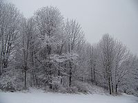
Winter storm
A winter storm is an event in which the dominant varieties of precipitation are formed that only occur at low temperatures, such as snow or sleet, or a rainstorm where ground temperatures are low enough to allow ice to form...
is an event in which the dominant varieties of precipitation
Precipitation (meteorology)
In meteorology, precipitation In meteorology, precipitation In meteorology, precipitation (also known as one of the classes of hydrometeors, which are atmospheric water phenomena is any product of the condensation of atmospheric water vapor that falls under gravity. The main forms of precipitation...
are forms that only occur at cold temperature
Temperature
Temperature is a physical property of matter that quantitatively expresses the common notions of hot and cold. Objects of low temperature are cold, while various degrees of higher temperatures are referred to as warm or hot...
s, such as snow
Snow
Snow is a form of precipitation within the Earth's atmosphere in the form of crystalline water ice, consisting of a multitude of snowflakes that fall from clouds. Since snow is composed of small ice particles, it is a granular material. It has an open and therefore soft structure, unless packed by...
or sleet
Rain and snow mixed
Rain and snow mixed is precipitation composed of rain and partially melted snow. This precipitation can occur where the temperature in the lower part of the atmosphere is slightly above the freezing point...
, or a rainstorm where ground temperatures are cold enough to allow ice
Ice
Ice is water frozen into the solid state. Usually ice is the phase known as ice Ih, which is the most abundant of the varying solid phases on the Earth's surface. It can appear transparent or opaque bluish-white color, depending on the presence of impurities or air inclusions...
to form (i.e. freezing rain
Freezing rain
Freezing rain is the name given to rain that falls when surface temperatures are below freezing. The raindrops become supercooled while passing through a sub-freezing layer of air, many hundred feet , just above the surface, and then freeze upon impact with any object they encounter. The resulting...
). It may be marked by strong wind
Wind
Wind is the flow of gases on a large scale. On Earth, wind consists of the bulk movement of air. In outer space, solar wind is the movement of gases or charged particles from the sun through space, while planetary wind is the outgassing of light chemical elements from a planet's atmosphere into space...
, thunder
Thunder
Thunder is the sound made by lightning. Depending on the nature of the lightning and distance of the listener, thunder can range from a sharp, loud crack to a long, low rumble . The sudden increase in pressure and temperature from lightning produces rapid expansion of the air surrounding and within...
and lightning
Lightning
Lightning is an atmospheric electrostatic discharge accompanied by thunder, which typically occurs during thunderstorms, and sometimes during volcanic eruptions or dust storms...
(a thunderstorm
Thunderstorm
A thunderstorm, also known as an electrical storm, a lightning storm, thundershower or simply a storm is a form of weather characterized by the presence of lightning and its acoustic effect on the Earth's atmosphere known as thunder. The meteorologically assigned cloud type associated with the...
), heavy precipitation
Precipitation (meteorology)
In meteorology, precipitation In meteorology, precipitation In meteorology, precipitation (also known as one of the classes of hydrometeors, which are atmospheric water phenomena is any product of the condensation of atmospheric water vapor that falls under gravity. The main forms of precipitation...
, such as ice
Ice
Ice is water frozen into the solid state. Usually ice is the phase known as ice Ih, which is the most abundant of the varying solid phases on the Earth's surface. It can appear transparent or opaque bluish-white color, depending on the presence of impurities or air inclusions...
(ice storm
Winter storm
A winter storm is an event in which the dominant varieties of precipitation are formed that only occur at low temperatures, such as snow or sleet, or a rainstorm where ground temperatures are low enough to allow ice to form...
), or wind transporting some substance through the atmosphere
Earth's atmosphere
The atmosphere of Earth is a layer of gases surrounding the planet Earth that is retained by Earth's gravity. The atmosphere protects life on Earth by absorbing ultraviolet solar radiation, warming the surface through heat retention , and reducing temperature extremes between day and night...
(as in a dust storm
Dust storm
A dust / sand storm is a meteorological phenomenon common in arid and semi-arid regions. Dust storms arise when a gust front or other strong wind blows loose sand and dirt from a dry surface. Particles are transported by saltation and suspension, causing soil to move from one place and deposition...
, snowstorm, hail
Hail
Hail is a form of solid precipitation. It consists of balls or irregular lumps of ice, each of which is referred to as a hail stone. Hail stones on Earth consist mostly of water ice and measure between and in diameter, with the larger stones coming from severe thunderstorms...
storm, etc.). Major dust storms, Hurricanes, cyclone
Cyclone
In meteorology, a cyclone is an area of closed, circular fluid motion rotating in the same direction as the Earth. This is usually characterized by inward spiraling winds that rotate anticlockwise in the Northern Hemisphere and clockwise in the Southern Hemisphere of the Earth. Most large-scale...
s, tornado
Tornado
A tornado is a violent, dangerous, rotating column of air that is in contact with both the surface of the earth and a cumulonimbus cloud or, in rare cases, the base of a cumulus cloud. They are often referred to as a twister or a cyclone, although the word cyclone is used in meteorology in a wider...
s, gale
Gale
A gale is a very strong wind. There are conflicting definitions of how strong a wind must be to be considered a gale. The U.S. government's National Weather Service defines a gale as 34–47 knots of sustained surface winds. Forecasters typically issue gale warnings when winds of this strength are...
s, flooding and rainstorms are also caused by such phenomena to a lesser or greater existent.
A storm (from Proto-Germanic *sturmaz "noise, tumult") is any disturbed state of an astronomical body's atmosphere, especially affecting its surface, and strongly implying severe weather
Severe weather
Severe weather phenomena are weather conditions that are hazardous to human life and property.- Examples Include :Severe weather can occur under a variety of situations, but three characteristics are generally needed: a temperature or moisture boundary, moisture, and , instability in the...
. It may be marked by strong wind
Wind
Wind is the flow of gases on a large scale. On Earth, wind consists of the bulk movement of air. In outer space, solar wind is the movement of gases or charged particles from the sun through space, while planetary wind is the outgassing of light chemical elements from a planet's atmosphere into space...
, thunder
Thunder
Thunder is the sound made by lightning. Depending on the nature of the lightning and distance of the listener, thunder can range from a sharp, loud crack to a long, low rumble . The sudden increase in pressure and temperature from lightning produces rapid expansion of the air surrounding and within...
and lightning
Lightning
Lightning is an atmospheric electrostatic discharge accompanied by thunder, which typically occurs during thunderstorms, and sometimes during volcanic eruptions or dust storms...
(a thunderstorm
Thunderstorm
A thunderstorm, also known as an electrical storm, a lightning storm, thundershower or simply a storm is a form of weather characterized by the presence of lightning and its acoustic effect on the Earth's atmosphere known as thunder. The meteorologically assigned cloud type associated with the...
), heavy precipitation
Precipitation (meteorology)
In meteorology, precipitation In meteorology, precipitation In meteorology, precipitation (also known as one of the classes of hydrometeors, which are atmospheric water phenomena is any product of the condensation of atmospheric water vapor that falls under gravity. The main forms of precipitation...
, such as ice
Ice
Ice is water frozen into the solid state. Usually ice is the phase known as ice Ih, which is the most abundant of the varying solid phases on the Earth's surface. It can appear transparent or opaque bluish-white color, depending on the presence of impurities or air inclusions...
(ice storm
Winter storm
A winter storm is an event in which the dominant varieties of precipitation are formed that only occur at low temperatures, such as snow or sleet, or a rainstorm where ground temperatures are low enough to allow ice to form...
), or wind transporting some substance through the atmosphere
Earth's atmosphere
The atmosphere of Earth is a layer of gases surrounding the planet Earth that is retained by Earth's gravity. The atmosphere protects life on Earth by absorbing ultraviolet solar radiation, warming the surface through heat retention , and reducing temperature extremes between day and night...
(as in a dust storm
Dust storm
A dust / sand storm is a meteorological phenomenon common in arid and semi-arid regions. Dust storms arise when a gust front or other strong wind blows loose sand and dirt from a dry surface. Particles are transported by saltation and suspension, causing soil to move from one place and deposition...
, snowstorm, hail
Hail
Hail is a form of solid precipitation. It consists of balls or irregular lumps of ice, each of which is referred to as a hail stone. Hail stones on Earth consist mostly of water ice and measure between and in diameter, with the larger stones coming from severe thunderstorms...
storm, etc.).
Storms are created when a centre of low pressure
Low pressure area
A low-pressure area, or "low", is a region where the atmospheric pressure at sea level is below that of surrounding locations. Low-pressure systems form under areas of wind divergence which occur in upper levels of the troposphere. The formation process of a low-pressure area is known as...
develops, with a system of high pressure
High pressure area
A high-pressure area is a region where the atmospheric pressure at the surface of the planet is greater than its surrounding environment. Winds within high-pressure areas flow outward due to the higher density air near their center and friction with land...
surrounding it. This combination of opposing forces can create winds and result in the formation of storm clouds, such as the cumulonimbus
Cumulonimbus cloud
Cumulonimbus is a towering vertical cloud that is very tall, dense, and involved in thunderstorms and other inclement weather. Cumulonimbus originates from Latin: Cumulus "Heap" and nimbus "rain". It is a result of atmospheric instability. These clouds can form alone, in clusters, or along a cold...
. Small, localized areas of low pressure can form from hot air rising off hot ground, resulting in smaller meteorological disturbances such as dust devils
Dust Devils
Dust Devils is an independently published role-playing game set in the Old West, written by Matt Snyder. It was voted the 2002 Indie RPG of the Year; it also won the Best Synergy of Game and Rules category, as well as placing in the Best Production and Most Innovative Game categories.The game uses...
and whirlwinds.
December 30 – January 2
Newfoundland and Labrador
Newfoundland and Labrador is the easternmost province of Canada. Situated in the country's Atlantic region, it incorporates the island of Newfoundland and mainland Labrador with a combined area of . As of April 2011, the province's estimated population is 508,400...
on December 30 while a second storm gave a foot of snow over Prince Edward Island
Prince Edward Island
Prince Edward Island is a Canadian province consisting of an island of the same name, as well as other islands. The maritime province is the smallest in the nation in both land area and population...
and several inches of snow across New Brunswick
New Brunswick
New Brunswick is one of Canada's three Maritime provinces and is the only province in the federation that is constitutionally bilingual . The provincial capital is Fredericton and Saint John is the most populous city. Greater Moncton is the largest Census Metropolitan Area...
and portions of New England
New England
New England is a region in the northeastern corner of the United States consisting of the six states of Maine, New Hampshire, Vermont, Massachusetts, Rhode Island, and Connecticut...
and Ontario
Ontario
Ontario is a province of Canada, located in east-central Canada. It is Canada's most populous province and second largest in total area. It is home to the nation's most populous city, Toronto, and the nation's capital, Ottawa....
on December 30–31 while Nova Scotia received a mix of snow, rain and ice pellets. Several New Year's Eve festivities including Charlottetown
Charlottetown
Charlottetown is a Canadian city. It is both the largest city on and the provincial capital of Prince Edward Island, and the county seat of Queens County. Named after Queen Charlotte, the wife of George III, Charlottetown was first incorporated as a town in 1855 and designated as a city in 1885...
's main event as well as the fireworks show in St. John's
St. John's, Newfoundland and Labrador
St. John's is the capital and largest city in Newfoundland and Labrador, and is the oldest English-founded city in North America. It is located on the eastern tip of the Avalon Peninsula on the island of Newfoundland. With a population of 192,326 as of July 1, 2010, the St...
were cancelled due to weather conditions.
As part of a third storm, a burst of snow, some of it lake enhanced
Lake effect snow
Lake-effect snow is produced during cooler atmospheric conditions when cold winds move across long expanses of warmer lake water, providing energy and picking up water vapor which freezes and is deposited on the leeward shores...
, affected The Great Lakes from mid-afternoon New Year's Eve until mid-afternoon New Year's Day. Particularly hit hard were the cities of Chicago, Detroit, and Cleveland. 3 to 6 inches (15.2 cm) of snow fell in many areas, with many parts of Michigan seeing over a foot of snow, including Capac, Michigan
Capac, Michigan
Capac is a village in Mussey Township, St. Clair County in the U.S. state of Michigan. The population was 1,775 at the 2000 census.-History:Capac was founded and platted by a group of men from Romeo headed by George R. Funstan and Judge DeWitt C. Walker in 1857. The judge named it after Huayna...
, which reported 16 inches (40.6 cm) of snow. 36,000 people lost power in southeastern Michigan, and 10,000 lost power in Northeast Ohio. Detroit Metropolitan Airport and Chicago-O'Hare International Airport both reported numerous delays and 145 flights were canceled at O'Hare alone. There were no serious injuries or fatalities reported, but many spinouts and other accidents occurred.
January 2–3
A major winter storm event took place across portions of central Europe including BulgariaBulgaria
Bulgaria , officially the Republic of Bulgaria , is a parliamentary democracy within a unitary constitutional republic in Southeast Europe. The country borders Romania to the north, Serbia and Macedonia to the west, Greece and Turkey to the south, as well as the Black Sea to the east...
, Ukraine
Ukraine
Ukraine is a country in Eastern Europe. It has an area of 603,628 km², making it the second largest contiguous country on the European continent, after Russia...
, Romania
Romania
Romania is a country located at the crossroads of Central and Southeastern Europe, on the Lower Danube, within and outside the Carpathian arch, bordering on the Black Sea...
and southwestern Russia as well as areas near the Black Sea
Black Sea
The Black Sea is bounded by Europe, Anatolia and the Caucasus and is ultimately connected to the Atlantic Ocean via the Mediterranean and the Aegean seas and various straits. The Bosphorus strait connects it to the Sea of Marmara, and the strait of the Dardanelles connects that sea to the Aegean...
. The storm was responsible for the sinking of the M/S Vanessa, a Bulgarian cargo ship on the Kerch Strait, killing at least 4 sailors. Up to 2 feet (61 cm) of snow fell across portions Bulgaria and Romania severely disrupting transportation including the closure of Bucharest
Bucharest
Bucharest is the capital municipality, cultural, industrial, and financial centre of Romania. It is the largest city in Romania, located in the southeast of the country, at , and lies on the banks of the Dâmbovița River....
's two main airports as well several ports around the Black Sea were also shut down. Electricity was also cut in about 300 towns and villages in Bulgaria and deliveries of food and water were also delayed.
January 4–9
Heavy snow fell in the Sierra Nevada and CascadeCascade Range
The Cascade Range is a major mountain range of western North America, extending from southern British Columbia through Washington and Oregon to Northern California. It includes both non-volcanic mountains, such as the North Cascades, and the notable volcanoes known as the High Cascades...
mountains from three storms. The heaviest snow occurred in the mountains south of Lake Tahoe
Lake Tahoe
Lake Tahoe is a large freshwater lake in the Sierra Nevada of the United States. At a surface elevation of , it is located along the border between California and Nevada, west of Carson City. Lake Tahoe is the largest alpine lake in North America. Its depth is , making it the USA's second-deepest...
, with Kirkwood Mountain Resort
Kirkwood Mountain Resort
Kirkwood Mountain Resort is a year-round resort in Kirkwood, California south of Lake Tahoe that focuses on skiing and snowboarding in winter and hiking and mountain-biking in summer. Kirkwood is one of the region's larger resorts, and is well known for having one of the highest average snowfalls...
receiving 11 feet (335.3 cm) of snow. Sierra-at-Tahoe
Sierra-at-Tahoe
Sierra-at-Tahoe is a ski and snowboard resort in Twin Bridges, California south of Lake Tahoe. Sierra-at-Tahoe is approximately 16 miles south of Stateline, Nevada and 12 miles south of South Lake Tahoe on Highway 50 and is contained within the Eldorado National Forest...
and Heavenly Ski Resort
Heavenly Ski Resort
Heavenly Mountain Resort is a ski resort located on the California-Nevada border in South Lake Tahoe. It has 97 runs and 30 lifts that are spread between California and Nevada and four base facilities...
both received up to 8 feet (243.8 cm) of snow. Snow depths of at least 5 feet (152.4 cm) were widely reported. The snow was combined with wind gusts exceeding 100 mi/h, creating blizzard and white-out conditions in the Sierra Nevada. The highest reported wind gust was 163 mph (265 km/h) on Ward Mountain
Ward Mountain
Ward Mountain is the high point of the Egan Range in south-central White Pine County of eastern Nevada. The summit, part of a three mile long crest, is located just south of the community of Ely. The Ward Charcoal Ovens State Historic Park is located on the mountain's eastern flank....
. Widespread reports of 3–6 inches of rain were received, and at the height of the storm approximately 2 million people were without power in California
California
California is a state located on the West Coast of the United States. It is by far the most populous U.S. state, and the third-largest by land area...
. About 3,000 people in Orange County, California
Orange County, California
Orange County is a county in the U.S. state of California. Its county seat is Santa Ana. As of the 2010 census, its population was 3,010,232, up from 2,846,293 at the 2000 census, making it the third most populous county in California, behind Los Angeles County and San Diego County...
were forced to evacuate their homes because of mudslide concerns in areas that had recently been burned in wildfire
Wildfire
A wildfire is any uncontrolled fire in combustible vegetation that occurs in the countryside or a wilderness area. Other names such as brush fire, bushfire, forest fire, desert fire, grass fire, hill fire, squirrel fire, vegetation fire, veldfire, and wilkjjofire may be used to describe the same...
s. These storms continued through the Intermountain West
Intermountain West
The Intermountain West is a region of North America lying between the Rocky Mountains to the east and the Cascades and Sierra Nevada to the west. It is also called the Intermountain Region.- Topography :...
and into the Rocky Mountains
Rocky Mountains
The Rocky Mountains are a major mountain range in western North America. The Rocky Mountains stretch more than from the northernmost part of British Columbia, in western Canada, to New Mexico, in the southwestern United States...
. Heavy snow of 2–4 feet occurred in the San Juan Mountains
San Juan Mountains
The San Juan Mountains are a high and rugged mountain range in the Rocky Mountains in southwestern Colorado. The area is highly mineralized and figured in the gold and silver mining industry of early Colorado. Major towns, all old mining camps, include Creede, Lake City, Silverton, Ouray, and...
of Colorado
Colorado
Colorado is a U.S. state that encompasses much of the Rocky Mountains as well as the northeastern portion of the Colorado Plateau and the western edge of the Great Plains...
, with a maximum of 50 inches (127 cm) reported at the Silverton
Silverton, Colorado
The town of Silverton is a Statutory Town that is the county seat of, and the only incorporated municipality in, San Juan County, Colorado, United States. Silverton is a former silver mining camp, most or all of which is now included in a federally designated National Historic Landmark District,...
Mountain Resort. Six snowmobilers who were stranded by the storm in southern Colorado found shelter in a cabin. However, 3 people were still missing; one hiker in the San Bernardino Mountains
San Bernardino Mountains
The San Bernardino Mountains are a short transverse mountain range north and east of San Bernardino in Southern California in the United States. The mountains run for approximately 60 miles east-west on the southern edge of the Mojave Desert in southwestern San Bernardino County, north of the...
in southern California, and two skiers in Colorado near Wolf Creek Pass
Wolf Creek Pass
Wolf Creek Pass is a high mountain pass on the Continental Divide, in the San Juan Mountains of Colorado. It is the route through which U.S. Highway 160 passes from the San Luis Valley into southwest Colorado on its way to New Mexico and Arizona. The pass is notable as inspiration of a C. W....
. At least three people were confirmed killed in the storm. A woman died when she drove her car across a flooded road in Chino, California
Chino, California
Chino is a city in San Bernardino County, California, United States. It is located in the western end of the Riverside-San Bernardino Area and it is easily accessible via the Chino Valley and Pomona freeways....
, one person was killed by a falling branch in Sacramento
Sacramento, California
Sacramento is the capital city of the U.S. state of California and the county seat of Sacramento County. It is located at the confluence of the Sacramento River and the American River in the northern portion of California's expansive Central Valley. With a population of 466,488 at the 2010 census,...
, and person was killed by a falling tree in Central Point, Oregon
Central Point, Oregon
Central Point is a city in Jackson County, Oregon, United States. The population was 17,165 as of July 1, 2009 The city shares its southern border with Medford and is a part of the Medford metropolitan area...
. Two bodies discovered in Sacramento near a homeless camp were also being investigated as possibly weather-related. In Fernley, Nevada
Fernley, Nevada
Fernley is a city in Lyon County, Nevada, United States, within Reno-Sparks-Lake Tahoe metropolitan. The city incorporated in 2001, including land in Washoe County; prior to that it was a census-designated place . The population of the CDP was 8,543 at the 2000 census; the city itself had an...
an irrigation ditch burst and flooded 290 homes with up to 8 feet (2.4 m) of water; the cold weather then caused the water to freeze. In southeastern Utah, nine people were killed and 20 injured after a charter bus returning from a ski trip in Telluride, Colorado
Telluride, Colorado
The town of Telluride is the county seat and most populous town of San Miguel County in the southwestern portion of the U.S. state of Colorado. The town is a former silver mining camp on the San Miguel River in the western San Juan Mountains...
ran off the road north of Mexican Hat
Mexican Hat, Utah
Mexican Hat is a census-designated place on the San Juan River in south-central San Juan County, Utah, United States. Each year, on March 8 the town members meet to celebrate their CDP status. Town members wear hats, as the celebration takes place at the Mexican Hat Rock. It is on U.S...
. However, it was unknown if slick roads were the primary cause of the crash.
January 5–7
A major snowstorm that dropped the heaviest snow in more than a decade in northern IranIran
Iran , officially the Islamic Republic of Iran , is a country in Southern and Western Asia. The name "Iran" has been in use natively since the Sassanian era and came into use internationally in 1935, before which the country was known to the Western world as Persia...
killed at least 21 people and injured at least 88, with some people freezing to death, others dying in avalanches, and some dying after their cars overturned on snow-covered roads. Anywhere from 15–50 cm (6–20 inches) of snow were recorded in Tehran
Tehran
Tehran , sometimes spelled Teheran, is the capital of Iran and Tehran Province. With an estimated population of 8,429,807; it is also Iran's largest urban area and city, one of the largest cities in Western Asia, and is the world's 19th largest city.In the 20th century, Tehran was subject to...
, while about 90 cm (3 ft) of snow fell in the Caspian Sea
Caspian Sea
The Caspian Sea is the largest enclosed body of water on Earth by area, variously classed as the world's largest lake or a full-fledged sea. The sea has a surface area of and a volume of...
town of Bandar-e Anzali
Bandar-e Anzali
Bandar-e Anzali , also Romanized as Bandar-e Pahlavī, Bandar Pahlavi, and Bandar Pahlevi, or simply as Pahlavī, Pahlevī, and Pehlevi; earlier, Enceli and Enzeli) is a city in and the capital of Bandar-e Anzali County, Gilan Province, Iran...
in Gīlān Province
Gilan Province
Gilan Province is one of the 31 provinces of Iran. It lies along the Caspian Sea, just west of the province of Mazandaran, east of the province of Ardabil, north of the provinces of Zanjan and Qazvin....
in northwestern Iran, usually a mild, damp place in winter. "Heavy" sea-effect snow also fell in Baku
Baku
Baku , sometimes spelled as Baki or Bakou, is the capital and largest city of Azerbaijan, as well as the largest city on the Caspian Sea and of the Caucasus region. It is located on the southern shore of the Absheron Peninsula, which projects into the Caspian Sea. The city consists of two principal...
, Azerbaijan
Azerbaijan
Azerbaijan , officially the Republic of Azerbaijan is the largest country in the Caucasus region of Eurasia. Located at the crossroads of Western Asia and Eastern Europe, it is bounded by the Caspian Sea to the east, Russia to the north, Georgia to the northwest, Armenia to the west, and Iran to...
.
January 13–14
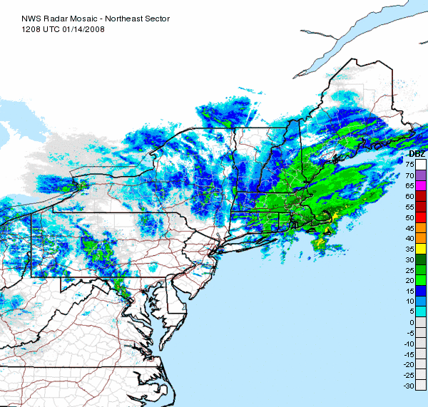
Nor'easter
A nor'easter is a type of macro-scale storm along the East Coast of the United States and Atlantic Canada, so named because the storm travels to the northeast from the south and the winds come from the northeast, especially in the coastal areas of the Northeastern United States and Atlantic Canada...
developed along the Mid-atlantic coast, and moved northward. It affected the northeastern United States, eastern Quebec and the Canadian Maritimes with heavy snow, and high winds along the coast.Several areas across Maine, New Brunswick received snow amounts in excess of 1 foot (0.3048 m) with as much as 20 inches (50.8 cm) locally across the Gaspe
Gaspé, Quebec
Gaspé is a city at the tip of the Gaspé Peninsula in the Gaspésie–Îles-de-la-Madeleine region of eastern Quebec, Canada. As of the 2006 census, the city had a total population of 14,819....
region.
January 17–18
A low pressure system moving northward up the East Coast caused snow and rain to overspread the Mid-Atlantic region on January 17 and 18. Many spots started off as snow, with a gradual changeover to sleet, freezing rain and then finally rain as the storm slowed down. The greatest concern for accumulating ice was in western North Carolina, while the greatest accumulations of snow was expected in the Shenandoah Valley. Lighter accumulations of snow were expected along and west of I-95 in the Baltimore-Washington metro area, making for a difficult commute that afternoon. Winter storm watches and warnings extended from northern Georgia into southern Pennsylvania.The wintry mix continued to spread northward overnight and into Friday. While New York and Boston saw mainly rain, accumulating snow occurred through the upper Delaware Valley and into the Hudson River Valley. The heaviest snow on Friday was expected for northern New Hampshire into Maine.
January 24–31
A rapid-fire series of major winter storms affected the western United States over the last week of January. The storms focused on CaliforniaCalifornia
California is a state located on the West Coast of the United States. It is by far the most populous U.S. state, and the third-largest by land area...
at first, bringing heavy rain and snow to the state. Up to 6 feet (182.9 cm) of snow fell in the Sierra Nevada early on, with 2–5 inches of rain falling in the lowlands of California and up to 8 inches (203.2 mm) in the foothills. The heaviest rains occurred around Santa Barbara
Santa Barbara, California
Santa Barbara is the county seat of Santa Barbara County, California, United States. Situated on an east-west trending section of coastline, the longest such section on the West Coast of the United States, the city lies between the steeply-rising Santa Ynez Mountains and the Pacific Ocean...
. Many areas of southern California received more rain during these storms than what they saw the entire previous water year. Heavy snow periodically closed Interstate 5
Interstate 5
Interstate 5 is the main Interstate Highway on the West Coast of the United States, running largely parallel to the Pacific Ocean coastline from Canada to Mexico . It serves some of the largest cities on the U.S...
over the Grapevine
Grapevine, California
Grapevine is an unincorporated community in Kern County, California. At an elevation of 1499 feet , the community is located at the foot of a road grade known as The Grapevine through the Grapevine Canyon to Tejon Pass in the Tehachapi Mountains at the southern end of the San Joaquin Valley along...
(north of Los Angeles
Los Ángeles
Los Ángeles is the capital of the province of Biobío, in the commune of the same name, in Region VIII , in the center-south of Chile. It is located between the Laja and Biobío rivers. The population is 123,445 inhabitants...
) due to the snow, as well as jackknifed tractor trailers, which stranded about 300 motorists for several hours. Heavy snow pounded all of the mountains of California
California
California is a state located on the West Coast of the United States. It is by far the most populous U.S. state, and the third-largest by land area...
, and 3 skiers were killed by avalanches on January 24 in the San Gabriel Mountains
San Gabriel Mountains
The San Gabriel Mountains Range is located in northern Los Angeles County and western San Bernardino County, California, United States. The mountain range lies between the Los Angeles Basin and the Mojave Desert, with Interstate 5 to the west and Interstate 15 to the east...
, where locally 5 feet (150 cm) of snow fell in the storm. Several mudslides and flash floods were reported in Orange County
Orange County, California
Orange County is a county in the U.S. state of California. Its county seat is Santa Ana. As of the 2010 census, its population was 3,010,232, up from 2,846,293 at the 2000 census, making it the third most populous county in California, behind Los Angeles County and San Diego County...
and in Los Angeles, while several residents were forced to be evacuated from their homes in Marin County
Marin County, California
Marin County is a county located in the North San Francisco Bay Area of the U.S. state of California, across the Golden Gate Bridge from San Francisco. As of 2010, the population was 252,409. The county seat is San Rafael and the largest employer is the county government. Marin County is well...
. A Metrolink
Metrolink (Southern California)
Metrolink is a commuter rail system serving Los Angeles and the surrounding area of Southern California; it currently consists of six lines and 55 stations using of track....
commuter train in Los Angeles hit mud and rocks that partially covered the tracks, causing it to be stranded along with its hundreds of passengers for over 2 hours before another train pulled it out from the debris. Wind gusts of 40–50 mph also affected areas of southern California. Combined with the heavy wind and rain in the region, widespread though spotty power cuts were reported.
Heavy snow also spread into the Inland Empire
Inland Empire (Pacific Northwest)
thumb|The Inland Empire regionThe Inland Northwest, or Inland Empire, is a region in the Pacific Northwest centered on Spokane, Washington, including the surrounding Columbia River basin and all of North Idaho....
of the Pacific Northwest
Pacific Northwest
The Pacific Northwest is a region in northwestern North America, bounded by the Pacific Ocean to the west and, loosely, by the Rocky Mountains on the east. Definitions of the region vary and there is no commonly agreed upon boundary, even among Pacific Northwesterners. A common concept of the...
. The Spokane, Washington
Spokane, Washington
Spokane is a city located in the Northwestern United States in the state of Washington. It is the largest city of Spokane County of which it is also the county seat, and the metropolitan center of the Inland Northwest region...
and Coeur d'Alene, Idaho
Coeur d'Alene, Idaho
Coeur d'Alene is the largest city and county seat of Kootenai County, Idaho, United States. It is the principal city of the Coeur d'Alene Metropolitan Statistical Area. Coeur d'Alene has the second largest metropolitan area in the state of Idaho. As of the 2010 census the population of Coeur...
areas saw two powerful storms during this time period, with local amounts of more than 2 feet (61 cm) in a storm from the 26th–27th, with 13.7 inches (34.8 cm) in Spokane and up to 6 inches (15.2 cm) in Eugene, Oregon
Eugene, Oregon
Eugene is the second largest city in the U.S. state of Oregon and the seat of Lane County. It is located at the south end of the Willamette Valley, at the confluence of the McKenzie and Willamette rivers, about east of the Oregon Coast.As of the 2010 U.S...
. This storm caused numerous roofs to collapse near Coeur d'Alene. Another storm from late on the 30th to the 31st dropping up to 18 inches (45.7 cm) of snow in Pullman, Washington
Pullman, Washington
Pullman is the largest city in Whitman County, Washington, United States. The population was 24,675 at the 2000 census and 29,799 according to the 2010 census...
and Moscow, Idaho
Moscow, Idaho
Moscow is a city in northern Idaho, situated along the Washington/Idaho border. It is the most populous city and county seat of Latah County and the home of the University of Idaho, the land grant institution and primary research university for the state...
. Lewiston, Idaho
Lewiston, Idaho
Lewiston is a city in and also the county seat of Nez Perce County in the Pacific Northwest state of Idaho. It is the second-largest city in the northern Idaho region, behind Coeur d'Alene and ninth-largest in the state. Lewiston is the principal city of the Lewiston, ID - Clarkston, WA...
recorded 6.1 inches (15.5 cm) inches, Pendleton, Oregon
Pendleton, Oregon
Pendleton is a city in Umatilla County, Oregon, United States. Pendleton was named in 1868 by the county commissioners for George H. Pendleton, Democratic candidate for Vice-President in the 1864 presidential campaign. The population was 16,612 at the 2010 census...
9.3 inches (23.6 cm), and Spokane an additional 9.2 inches (23.4 cm). Numerous roads throughout the Spokane Valley, the Palouse
Palouse
The Palouse is a region of the northwestern United States, encompassing parts of southeastern Washington, north central Idaho and, in some definitions, extending south into northeast Oregon. It is a major agricultural area, primarily producing wheat and legumes...
, and the surrounding mountains were closed at various times during the storms. Several inches of snow even fell in Seattle
Seattle, Washington
Seattle is the county seat of King County, Washington. With 608,660 residents as of the 2010 Census, Seattle is the largest city in the Northwestern United States. The Seattle metropolitan area of about 3.4 million inhabitants is the 15th largest metropolitan area in the country...
and down to the Oregon
Oregon
Oregon is a state in the Pacific Northwest region of the United States. It is located on the Pacific coast, with Washington to the north, California to the south, Nevada on the southeast and Idaho to the east. The Columbia and Snake rivers delineate much of Oregon's northern and eastern...
coast (a very rare event). Local amounts of over 4 feet (121.9 cm) of snow fell in the Cascades. Interstate 90
Interstate 90
Interstate 90 is the longest Interstate Highway in the United States at . It is the northernmost coast-to-coast interstate, and parallels US 20 for the most part. Its western terminus is in Seattle, at Edgar Martinez Drive S. near Safeco Field and CenturyLink Field, and its eastern terminus is in...
over Snoqualmie Pass
Snoqualmie Pass
Snoqualmie Pass is a mountain pass that carries Interstate 90 through the Cascade Range in the U.S. State of Washington. The elevation of the pass summit is , and is on the county line between Kittitas County and King County...
, which had seen snowfall approaching 3 feet (91.4 cm), was hit by two avalanches in 3 days, the second of which buried 2 cars.
The mountains of Utah
Utah
Utah is a state in the Western United States. It was the 45th state to join the Union, on January 4, 1896. Approximately 80% of Utah's 2,763,885 people live along the Wasatch Front, centering on Salt Lake City. This leaves vast expanses of the state nearly uninhabited, making the population the...
and Colorado
Colorado
Colorado is a U.S. state that encompasses much of the Rocky Mountains as well as the northeastern portion of the Colorado Plateau and the western edge of the Great Plains...
also saw heavy snow of 2–4 feet during this time. The spate of late-month storms pushed Alta, Utah
Alta, Utah
Alta is a town in Salt Lake County, Utah, United States. It is part of the Salt Lake City, Utah Metropolitan Statistical Area. The population was 370 at the 2000 census, a slight decrease from the 1990 figure of 397....
to a monthly total of 178.5 inches (453.4 cm) of snow, tying its January record first set in 1996.
January 29
A major snowfall event affected portions of the Middle EastMiddle East
The Middle East is a region that encompasses Western Asia and Northern Africa. It is often used as a synonym for Near East, in opposition to Far East...
including Israel
Israel
The State of Israel is a parliamentary republic located in the Middle East, along the eastern shore of the Mediterranean Sea...
, Jordan
Jordan
Jordan , officially the Hashemite Kingdom of Jordan , Al-Mamlaka al-Urduniyya al-Hashemiyya) is a kingdom on the East Bank of the River Jordan. The country borders Saudi Arabia to the east and south-east, Iraq to the north-east, Syria to the north and the West Bank and Israel to the west, sharing...
, Syria
Syria
Syria , officially the Syrian Arab Republic , is a country in Western Asia, bordering Lebanon and the Mediterranean Sea to the West, Turkey to the north, Iraq to the east, Jordan to the south, and Israel to the southwest....
and Lebanon
Lebanon
Lebanon , officially the Republic of LebanonRepublic of Lebanon is the most common term used by Lebanese government agencies. The term Lebanese Republic, a literal translation of the official Arabic and French names that is not used in today's world. Arabic is the most common language spoken among...
. One of the areas mostly affected was Jerusalem where schools (including the Hebrew University of Jerusalem
Hebrew University of Jerusalem
The Hebrew University of Jerusalem ; ; abbreviated HUJI) is Israel's second-oldest university, after the Technion – Israel Institute of Technology. The Hebrew University has three campuses in Jerusalem and one in Rehovot. The world's largest Jewish studies library is located on its Edmond J...
), stores and transportation were shut down after 5 to 8 inches (20.3 cm) of snow fell. The main highway between Tel Aviv
Tel Aviv
Tel Aviv , officially Tel Aviv-Yafo , is the second most populous city in Israel, with a population of 404,400 on a land area of . The city is located on the Israeli Mediterranean coastline in west-central Israel. It is the largest and most populous city in the metropolitan area of Gush Dan, with...
and Jerusalem was also shortly closed because of the snow. The weather event had topped local headlines eclipsing a critical government report related to the 2006 Lebanon War and Israeli Prime Minister
Prime Minister of Israel
The Prime Minister of Israel is the head of the Israeli government and the most powerful political figure in Israel . The prime minister is the country's chief executive. The official residence of the prime minister, Beit Rosh Hamemshala is in Jerusalem...
Ehud Olmert
Ehud Olmert
Ehud Olmert is an Israeli politician and lawyer. He served as Prime Minister of Israel from 2006 to 2009, as a Cabinet Minister from 1988 to 1992 and from 2003 to 2006, and as Mayor of Jerusalem from 1993 to 2003....
.
January 10 – February 5
Several days of heavy wet snow, frigid temperatures and ice struck several regions of central China during the country's peak Lunar New YearChinese New Year
Chinese New Year – often called Chinese Lunar New Year although it actually is lunisolar – is the most important of the traditional Chinese holidays. It is an all East and South-East-Asia celebration...
Travel Season. At least 107 people were killed by the storm which stranded several thousands of people, canceled numerous flights and damaged or destroyed several homes, power lines and crops which had raised concerns for food and water shortage a. Among the fatalities, 11 were killed by a bus accident in Anhui with flipped into a ditch on January 21.
The provinces of Hubei
Hubei
' Hupeh) is a province in Central China. The name of the province means "north of the lake", referring to its position north of Lake Dongting...
, Henan
Henan
Henan , is a province of the People's Republic of China, located in the central part of the country. Its one-character abbreviation is "豫" , named after Yuzhou , a Han Dynasty state that included parts of Henan...
, Shandong
Shandong
' is a Province located on the eastern coast of the People's Republic of China. Shandong has played a major role in Chinese history from the beginning of Chinese civilization along the lower reaches of the Yellow River and served as a pivotal cultural and religious site for Taoism, Chinese...
, Jiangsu
Jiangsu
' is a province of the People's Republic of China, located along the east coast of the country. The name comes from jiang, short for the city of Jiangning , and su, for the city of Suzhou. The abbreviation for this province is "苏" , the second character of its name...
and Anhui
Anhui
Anhui is a province in the People's Republic of China. Located in eastern China across the basins of the Yangtze River and the Huai River, it borders Jiangsu to the east, Zhejiang to the southeast, Jiangxi to the south, Hubei to the southwest, Henan to the northwest, and Shandong for a tiny...
were the hardest hit areas where some areas received their worst snow storm in 50 years. Snow persisted throughout the week with bitterly cold temperatures accompanying it. Tens of thousands of people were left stranded at several trains stations across southern China including Guangzhou
Guangzhou
Guangzhou , known historically as Canton or Kwangchow, is the capital and largest city of the Guangdong province in the People's Republic of China. Located in southern China on the Pearl River, about north-northwest of Hong Kong, Guangzhou is a key national transportation hub and trading port...
Several main highways which also disrupted transportation of goods across several areas of the country.
Widespread power cuts were also reported and at one point, 17 of the 31 provinces had to endured reduced power supplies. It was estimated that about 827 000 people were evacuated across 14 provinces. The country's civil affairs ministry estimated that the severe weather affected 67 million people and that the costs were estimated at about 7.8 billion British pounds, 15.8 billion US Dollars or 111 billion Chinese yuan
Chinese yuan
The yuan is the base unit of a number of modern Chinese currencies. The yuan is the primary unit of account of the Renminbi.A yuán is also known colloquially as a kuài . One yuán is divided into 10 jiǎo or colloquially máo...
.
January 27 – February 2
Peter MacKay
Peter Gordon MacKay, PC, QC, MP is a lawyer and politician from Nova Scotia, Canada. He is the Member of Parliament for Central Nova and currently serves as Minister of National Defence in the Cabinet of Canada....
offered the province help with the services of the Canadian Armed Forces.
Meanwhile, another powerful storm moved across much of the continent, bringing first blizzard conditions and frigid temperatures from Alberta
Alberta
Alberta is a province of Canada. It had an estimated population of 3.7 million in 2010 making it the most populous of Canada's three prairie provinces...
to Manitoba
Manitoba
Manitoba is a Canadian prairie province with an area of . The province has over 110,000 lakes and has a largely continental climate because of its flat topography. Agriculture, mostly concentrated in the fertile southern and western parts of the province, is vital to the province's economy; other...
and down towards the Dakotas where temperatures dropped locally 40 degrees below zero with much colder windchills. While approaching the eastern half of the continent, it intensified further and brought widespread damage wind some of them from thunderstorms. Winds exceeded locally as much as 120 km/h in some areas while blowing snow shut down many roads near the shorelines of Georgian Bay
Georgian Bay
Georgian Bay is a large bay of Lake Huron, located entirely within Ontario, Canada...
and Lake Huron
Lake Huron
Lake Huron is one of the five Great Lakes of North America. Hydrologically, it comprises the larger portion of Lake Michigan-Huron. It is bounded on the east by the Canadian province of Ontario and on the west by the state of Michigan in the United States...
. The cold front associated with the depression produced very rapid temperature drops in a short period from Iowa to southern Ontario. The storm killed at least two in Indiana due to an EF2 tornado.
Texas Panhandle
The Texas Panhandle is a region of the U.S. state of Texas consisting of the northernmost 26 counties in the state. The panhandle is a rectangular area bordered by New Mexico to the west and Oklahoma to the north and east...
on January 31 and affected much of the Midwest and East with heavy snows from Northern Oklahoma to Quebec with significant ice across the Appalachians and the Ohio Valley and severe weather from southern Texas to the Middle Atlantic States. It brought massive amounts of snow to the Midwest with some isolated reports of 11 inches (279.4 mm) of snow. Chicago saw its largest snowstorm this season as it dropped over ten inches (203 mm) of snow in downtown, building up traffic delays.http://www.crh.noaa.gov/crnews/display_story.php?wfo=lot&storyid=12666&source=0 Across Ontario and Quebec it dumped about 8 inches of snow (20 cm) in Toronto, 13 to 14 inches (32–35 cm) in Ottawa, Gatineau and Quebec City and 11 inches (27 cm) in Montreal with higher amounts as much as 22 inches (55 cm) in the mountains north of Quebec City. It also brought severe weather to the deep south bringing several inches of rain. The storm also produced heavy sleet
Ice storm
An ice storm is a type of winter storm characterized by freezing rain, also known as a glaze event or in some parts of the United States as a silver thaw. The U.S. National Weather Service defines an ice storm as a storm which results in the accumulation of at least of ice on exposed surfaces...
and freezing rain
Freezing rain
Freezing rain is the name given to rain that falls when surface temperatures are below freezing. The raindrops become supercooled while passing through a sub-freezing layer of air, many hundred feet , just above the surface, and then freeze upon impact with any object they encounter. The resulting...
in much of Pennsylvania
Pennsylvania
The Commonwealth of Pennsylvania is a U.S. state that is located in the Northeastern and Mid-Atlantic regions of the United States. The state borders Delaware and Maryland to the south, West Virginia to the southwest, Ohio to the west, New York and Ontario, Canada, to the north, and New Jersey to...
and New York
New York
New York is a state in the Northeastern region of the United States. It is the nation's third most populous state. New York is bordered by New Jersey and Pennsylvania to the south, and by Connecticut, Massachusetts and Vermont to the east...
. The highest reported amount of ice accumulation was at State College, Pennsylvania
State College, Pennsylvania
State College is the largest borough in Centre County in the U.S. state of Pennsylvania. It is the principal city of the State College, Pennsylvania Metropolitan Statistical Area which encompasses all of Centre County. As of the 2010 census, the borough population was 42,034, and roughly double...
, where 0.75 inches (19.1 mm) of ice fell, coupled with moderate wind gusts, caused downed trees and powerlines there, and in much of the Northeast United States. The ice then moved into the Canadian Maritimes for several hours. While it disrupted air travel at various major airports along the path, the storm was responsible for at least 15 deaths across three states and one Canadian province including one in Ontario, four in New York, six in Illinois, three in Texas and one in Oklahoma.
February 5–6
A major winter storm affected the Central United StatesCentral United States
The Central United States is sometimes conceived as between the Eastern United States and Western United States as part of a three-region model, roughly coincident with the Midwestern United States plus the western and central portions of the Southern United States; the term is also sometimes used...
and southern Ontario
Ontario
Ontario is a province of Canada, located in east-central Canada. It is Canada's most populous province and second largest in total area. It is home to the nation's most populous city, Toronto, and the nation's capital, Ottawa....
from February 5 into February 6. The storm stretched from Wisconsin all the way south into Mississippi. Across eastern Iowa, southern Wisconsin, northern Illinois, and lower Michigan, the storm dumped upwards of a foot or more of snow, with locally heavier amounts of 20 inches (51 cm) in some areas, particularly across southeast Wisconsin. In Ontario, 12 inches (30 cm) of snow fell in Toronto (with locally heavier amounts) with other areas of Ontario from Windsor to Ottawa receiving up to 12 inches (30 cm). Winds of up to 25 miles per hour (40 km/h) and heavy snowfall rates made for blizzard conditions in some areas, making travel nearly impossible. Many places throughout northern Illinois and southern Wisconsin were forced to close on February 6, including schools, colleges, churches, health care centers, government buildings, businesses, and shopping malls. In addition, over 1000 flights were canceled at Chicago-O'Hare International Airport and 100 at Chicago-Midway International Airport while numerous flights were also cancelled at Toronto's Pearson International Airport. In the Milwuakee area, whiteout conditions forced the temporary closure of General Mitchell International Airport
General Mitchell International Airport
General Mitchell International Airport is a county-owned public airport located five miles south of the central business district of Milwaukee, a city in Milwaukee County, Wisconsin, United States....
, where half of its flights were canceled for the day. In addition, numerous accidents were reported across the area, including one fatality. Several interstates and other roadways were closed throughout Wisconsin due to either whiteout conditions or accidents. The National Guard was brought in to assist over 2000 stranded motorists on a 19 miles (30.6 km) stretch of I-90 between Janesville, WI, and Madison after several semi trailers lost traction and blocked the road.
The same storm system brought heavy rain across portions of the Ohio Valley, with severe thunderstorms further south. Kentucky, Arkansas, Tennessee, Mississippi, and Alabama all saw tornadoes from mid-afternoon February 5 to the early morning hours of February 6. 33 people were killed in Tennessee, 14 in Arkansas, 7 in Kentucky, and 5 in Alabama. In all, at least 59 people have been killed by the tornadoes, making it the deadliest outbreak since the 1985 United States-Canadian tornado outbreak of 1985, which killed 88 people. In addition, over 100 people have been injured. The storm tore off the roof of a shopping mall in Memphis, trapped college students at Union University
Union University
Union University is a private, evangelical Christian, liberal arts university located in Jackson, Tennessee, with additional campuses in Germantown, Tennessee, and Hendersonville, Tennessee...
in Jackson, Tennessee
Jackson, Tennessee
Jackson is a city in Madison County, Tennessee, United States. The total population was 65,211 at the 2010 census. Jackson is the primary city of the Jackson, Tennessee metropolitan area, which is included in the Jackson-Humboldt, Tennessee Combined Statistical Area...
, ignited a gas fire near Nashville, and demolished warehouses in Southaven, Mississippi
Southaven, Mississippi
-Households And Families:As of the census of 2000, there were 28,977 people, 11,007 households, and 8,134 families residing in the city. The population density was 857.9 people per square mile...
, in addition to destroying numerous homes. Over 103 separate tornadoes were reported. Several presidential candidates paused to remember victims during their speeches after the Super Tuesday primaries, with several tornadoes still occurring as they were speaking.
February 12–14
On February 11, a low pressure system moved out of the U.S. Plain States into the eastern half of the United States and eastern Canada. The low pressure system began to strengthen, and slowly moved east. Snow began to fall in on the northern side of the system as the storm moved off the coast. It all but stalled, and the snow soon turned to ice for most of the affected area. After the ice storm, temperatures warmed to above freezing, and most of the precipitation turned to all rain for all areas other than the far northern fringes of the storm. The rain lasted for several hours in many places, with some areas receiving 3 inches (7.5 cm) of rain, which caused minor flooding in low-lying and urban areas. As the primary low pressure system moved away, a smaller low formed, which enhanced rainfall and extended precipitation for several more hours. By early on February 14, the storm had moved away. On the northern side of the system between 10–20 cm of snow fell from Wisconsin to New Brunswick.February 17–18
A panhandle hook winter storm combined with an Alberta Clipper crossed the central United States, spreading rain, ice and heavy snow to parts of the upper Midwest and Northeast as well as eastern Canada from southern Manitoba to the Canadian Maritimes. Portions of Iowa and Manitoba were under blizzard warnings. Areas from northern Ontario to southern Wisconsin were under winter storm warnings while much of Ontario and Quebec were under freezing rain warnings. The ice event may have been blamed for a late-evening incident at the Ottawa International Airport where a Boeing 737Boeing 737
The Boeing 737 is a short- to medium-range, twin-engine narrow-body jet airliner. Originally developed as a shorter, lower-cost twin-engine airliner derived from Boeing's 707 and 727, the 737 has developed into a family of nine passenger models with a capacity of 85 to 215 passengers...
WestJet
WestJet
WestJet Airlines Ltd. is a Canadian low-cost carrier that provides scheduled and charter air service to 71 destinations in Canada, the United States, Mexico and the Caribbean. Founded in 1996, WestJet is currently the second largest Canadian air carrier, behind Air Canada, operating an average of...
flight from Calgary
Calgary
Calgary is a city in the Province of Alberta, Canada. It is located in the south of the province, in an area of foothills and prairie, approximately east of the front ranges of the Canadian Rockies...
slid off an icy runway and ending off into a snowbank. No injuries among the 94 passengers and crew members were reported in the incident.
Generally between 4 to 8 inches (10–20 cm) of snow fell across the Midwest and portions of Ontario although locally across Wisconsin amounts approached 1 foot (30 cm). The system was also notable for a tornado outbreak across Alabama, Georgia and Florida where dozens of tornadoes touched down injuring at least 30.
February 17–18
Heavy snowfall in Greece cut off access to at least 150 villages and was followed by a major cold snap. Significant power outages and water supply shortages were reported across many areas. Hardest hit areas were the island of CreteCrete
Crete is the largest and most populous of the Greek islands, the fifth largest island in the Mediterranean Sea, and one of the thirteen administrative regions of Greece. It forms a significant part of the economy and cultural heritage of Greece while retaining its own local cultural traits...
and Evia
Evia
Evia is a Spanish family name.* Edgar de EviaEvia as used in company names:* Evia Oyj, Finnish marketing communication agencyEvia is also an alternate spelling of:* The Greek island Euboea* The town Iŭje in Belarus...
as well as the southern portions of the Peloponnese
Peloponnese
The Peloponnese, Peloponnesos or Peloponnesus , is a large peninsula , located in a region of southern Greece, forming the part of the country south of the Gulf of Corinth...
Peninsula. In Athens
Athens
Athens , is the capital and largest city of Greece. Athens dominates the Attica region and is one of the world's oldest cities, as its recorded history spans around 3,400 years. Classical Athens was a powerful city-state...
, where at least 15 cm (6 in) fell, dozens of flights from the Athens Airport were cancelled while most schools throughout the city were shut down. Temperatures fell below minus 10 °C (15 °F) across northern Greece.
February 21–23
Northeastern United States
The Northeastern United States is a region of the United States as defined by the United States Census Bureau.-Composition:The region comprises nine states: the New England states of Connecticut, Maine, Massachusetts, New Hampshire, Rhode Island and Vermont; and the Mid-Atlantic states of New...
and Mid-Atlantic
Mid-Atlantic States
The Mid-Atlantic states, also called middle Atlantic states or simply the mid Atlantic, form a region of the United States generally located between New England and the South...
of the United States from February 21 onward. School closings, car accidents, and airport delays were reported in New York City. The FAA reported delays of up to 9 hours at LaGuardia Airport
LaGuardia Airport
LaGuardia Airport is an airport located in the northern part of Queens County on Long Island in the City of New York. The airport is located on the waterfront of Flushing Bay and Bowery Bay, and borders the neighborhoods of Astoria, Jackson Heights and East Elmhurst. The airport was originally...
, and delays averaging 3–5 hours at JFK Airport
John F. Kennedy International Airport
John F. Kennedy International Airport is an international airport located in the borough of Queens in New York City, about southeast of Lower Manhattan. It is the busiest international air passenger gateway to the United States, handling more international traffic than any other airport in North...
. In total, almost 1,100 flights were cancelled at New York City's three major airports. In New York City, 6 inches (15 cm) fell, while in northern New Jersey
New Jersey
New Jersey is a state in the Northeastern and Middle Atlantic regions of the United States. , its population was 8,791,894. It is bordered on the north and east by the state of New York, on the southeast and south by the Atlantic Ocean, on the west by Pennsylvania and on the southwest by Delaware...
, up to 13 inches (32.5 cm) accumulated. In addition, the speed limit on the New Jersey Turnpike
New Jersey Turnpike
The New Jersey Turnpike is a toll road in New Jersey, maintained by the New Jersey Turnpike Authority. According to the International Bridge, Tunnel and Turnpike Association, the Turnpike is the nation's sixth-busiest toll road and is among one of the most heavily traveled highways in the United...
was reduced to 35 mi/h, and in Greenwich, Connecticut
Greenwich, Connecticut
Greenwich is a town in Fairfield County, Connecticut, United States. As of the 2010 census, the town had a total population of 61,171. It is home to many hedge funds and other financial service companies. Greenwich is the southernmost and westernmost municipality in Connecticut and is 38+ minutes ...
, southbound lanes of Interstate 95
Interstate 95 in Connecticut
Interstate 95, the main north–south Interstate Highway on the East Coast of the United States, runs in a general east–west compass direction for 111.57 miles in Connecticut from the Rhode Island state line to the New York State line. I-95 Southbound from East Lyme to the New York State...
were closed for a couple hours.
Storm-related traffic accidents led to one death in Connecticut
Connecticut
Connecticut is a state in the New England region of the northeastern United States. It is bordered by Rhode Island to the east, Massachusetts to the north, and the state of New York to the west and the south .Connecticut is named for the Connecticut River, the major U.S. river that approximately...
while in Missouri
Missouri
Missouri is a US state located in the Midwestern United States, bordered by Iowa, Illinois, Kentucky, Tennessee, Arkansas, Oklahoma, Kansas and Nebraska. With a 2010 population of 5,988,927, Missouri is the 18th most populous state in the nation and the fifth most populous in the Midwest. It...
, where ice was the primary form of precipitation, 5 people were killed in accidents.
February 28 – March 2
A weak Alberta Clipper intensified over eastern Canada after dumping about 10–17 cm over Ontario and Quebec and several areas of the Northeastern United States. It brought another major winter storm for New Brunswick and eastern Quebec. Gaspé, QuebecGaspé, Quebec
Gaspé is a city at the tip of the Gaspé Peninsula in the Gaspésie–Îles-de-la-Madeleine region of eastern Quebec, Canada. As of the 2006 census, the city had a total population of 14,819....
received about 55 cm of snow while portions of New Brunswick received 25–30 cm. Strong winds in excess of 100 km/h forced the closure of the Confederation Bridge linking New Brunswick and Prince Edward Island.
March 1
A European windstormEuropean windstorm
A European windstorm is a severe cyclonic windstorm associated with areas of low atmospheric pressure that track across the North Atlantic towards northwestern Europe. They are most common in the winter months...
passed through Central Europe causing severe damage in Austria
Austria
Austria , officially the Republic of Austria , is a landlocked country of roughly 8.4 million people in Central Europe. It is bordered by the Czech Republic and Germany to the north, Slovakia and Hungary to the east, Slovenia and Italy to the south, and Switzerland and Liechtenstein to the...
, the Netherlands
Netherlands
The Netherlands is a constituent country of the Kingdom of the Netherlands, located mainly in North-West Europe and with several islands in the Caribbean. Mainland Netherlands borders the North Sea to the north and west, Belgium to the south, and Germany to the east, and shares maritime borders...
, Germany
Germany
Germany , officially the Federal Republic of Germany , is a federal parliamentary republic in Europe. The country consists of 16 states while the capital and largest city is Berlin. Germany covers an area of 357,021 km2 and has a largely temperate seasonal climate...
, easteren France
France
The French Republic , The French Republic , The French Republic , (commonly known as France , is a unitary semi-presidential republic in Western Europe with several overseas territories and islands located on other continents and in the Indian, Pacific, and Atlantic oceans. Metropolitan France...
, Poland
Poland
Poland , officially the Republic of Poland , is a country in Central Europe bordered by Germany to the west; the Czech Republic and Slovakia to the south; Ukraine, Belarus and Lithuania to the east; and the Baltic Sea and Kaliningrad Oblast, a Russian exclave, to the north...
and the Czech Republic
Czech Republic
The Czech Republic is a landlocked country in Central Europe. The country is bordered by Poland to the northeast, Slovakia to the east, Austria to the south, and Germany to the west and northwest....
and left 16 people dead (8 Germans, 4 Czechs, 2 Austrians, 1 Frenchman and 1 Pole). Windstorm Emma
Emma (windstorm)
Emma was a severe extratropical cyclone which passed through several mainly Central European countries, most devastatingly on Saturday March 1, 2008, killing at least twelve people in Austria, Germany, Poland and the Czech Republic. Wind speeds reached up to 166 km/h in Austria, and up to...
was a severe extratropical cyclone
Extratropical cyclone
Extratropical cyclones, sometimes called mid-latitude cyclones or wave cyclones, are a group of cyclones defined as synoptic scale low pressure weather systems that occur in the middle latitudes of the Earth having neither tropical nor polar characteristics, and are connected with fronts and...
which passed through several mainly Central Europe
Central Europe
Central Europe or alternatively Middle Europe is a region of the European continent lying between the variously defined areas of Eastern and Western Europe...
an countries, most devastatingly on Saturday March 1, 200, killing at least twelve people in Austria
Austria
Austria , officially the Republic of Austria , is a landlocked country of roughly 8.4 million people in Central Europe. It is bordered by the Czech Republic and Germany to the north, Slovakia and Hungary to the east, Slovenia and Italy to the south, and Switzerland and Liechtenstein to the...
, Germany
Germany
Germany , officially the Federal Republic of Germany , is a federal parliamentary republic in Europe. The country consists of 16 states while the capital and largest city is Berlin. Germany covers an area of 357,021 km2 and has a largely temperate seasonal climate...
, Poland
Poland
Poland , officially the Republic of Poland , is a country in Central Europe bordered by Germany to the west; the Czech Republic and Slovakia to the south; Ukraine, Belarus and Lithuania to the east; and the Baltic Sea and Kaliningrad Oblast, a Russian exclave, to the north...
and the Czech Republic
Czech Republic
The Czech Republic is a landlocked country in Central Europe. The country is bordered by Poland to the northeast, Slovakia to the east, Austria to the south, and Germany to the west and northwest....
. Wind speeds reached up to 166 km/h (103 mph) in Austria, and up to 180 km/h (112 mph) elsewhere. Major infrastructure disruptions and some injuries were also reported in Belgium
Belgium
Belgium , officially the Kingdom of Belgium, is a federal state in Western Europe. It is a founding member of the European Union and hosts the EU's headquarters, and those of several other major international organisations such as NATO.Belgium is also a member of, or affiliated to, many...
, France
France
The French Republic , The French Republic , The French Republic , (commonly known as France , is a unitary semi-presidential republic in Western Europe with several overseas territories and islands located on other continents and in the Indian, Pacific, and Atlantic oceans. Metropolitan France...
, Switzerland
Switzerland
Switzerland name of one of the Swiss cantons. ; ; ; or ), in its full name the Swiss Confederation , is a federal republic consisting of 26 cantons, with Bern as the seat of the federal authorities. The country is situated in Western Europe,Or Central Europe depending on the definition....
, and the Netherlands. Many trees were also bought down in SW British Isles
British Isles
The British Isles are a group of islands off the northwest coast of continental Europe that include the islands of Great Britain and Ireland and over six thousand smaller isles. There are two sovereign states located on the islands: the United Kingdom of Great Britain and Northern Ireland and...
as it passed over with winds at about 100 mph, affecting counties in Ireland, Wales and S.Western England. A Lufthansa
Lufthansa
Deutsche Lufthansa AG is the flag carrier of Germany and the largest airline in Europe in terms of overall passengers carried. The name of the company is derived from Luft , and Hansa .The airline is the world's fourth-largest airline in terms of overall passengers carried, operating...
jet almost crashed attempting to land in crosswinds at Hamburg. nd almost crashed whilst landing in high winds near Hamburg
Hamburg
-History:The first historic name for the city was, according to Claudius Ptolemy's reports, Treva.But the city takes its modern name, Hamburg, from the first permanent building on the site, a castle whose construction was ordered by the Emperor Charlemagne in AD 808...
.
March 3–5
Missouri
Missouri is a US state located in the Midwestern United States, bordered by Iowa, Illinois, Kentucky, Tennessee, Arkansas, Oklahoma, Kansas and Nebraska. With a 2010 population of 5,988,927, Missouri is the 18th most populous state in the nation and the fifth most populous in the Midwest. It...
and Arkansas
Arkansas
Arkansas is a state located in the southern region of the United States. Its name is an Algonquian name of the Quapaw Indians. Arkansas shares borders with six states , and its eastern border is largely defined by the Mississippi River...
with freezing rain across New York and Ohio. The low is expected to cross New England and give mixed precipitations for most of the Northeast as well as portions of Quebec and Ontario with heavier snow away from the Saint Lawrence River
Saint Lawrence River
The Saint Lawrence is a large river flowing approximately from southwest to northeast in the middle latitudes of North America, connecting the Great Lakes with the Atlantic Ocean. It is the primary drainage conveyor of the Great Lakes Basin...
and the Lower Great Lakes.
The freezing rain affected parts of Ohio where presidential primaries
Super Tuesday II, 2008
Super Tuesday II, 2008 is the name, also referred to as Super Tuesday 2.0, for 4 March 2008, the day on which the second largest simultaneous number of state presidential primary elections was held for the 2008 presidential election cycle. On this day, Mike Huckabee withdrew from the race when John...
were held but had little or no impact on the overall turnout. In Arkansas, where up to nearly one foot of snow fell locally, several schools were shut down in the western part of the state while other school closures were reported across the Midwest. About 8 to 10 inches (254 mm) fell in parts of Missouri and Michigan with localized amounts of thirteen inches (330 mm) near the St. Louis
St. Louis, Missouri
St. Louis is an independent city on the eastern border of Missouri, United States. With a population of 319,294, it was the 58th-largest U.S. city at the 2010 U.S. Census. The Greater St...
area. The winter storm disrupted the schedule of several March Madness
NCAA Men's Division I Basketball Championship
The NCAA Men's Division I Basketball Championship is a single-elimination tournament held each spring in the United States, featuring 68 college basketball teams, to determine the national championship in the top tier of college basketball...
Tournament basketball games across the Midwest. Nearly 12 000 customers in Illinois also lost power during the storm.
Heavy snow and local ice pellets and freezing rain fell throughout much Eastern Canada with the heaviest snow from north of the Great Lakes to north of the Saint Lawrence River from Toronto to eastern Quebec. From 4 to 12 inches (10–30 cm) of snow fell with the highest amounts in the Ottawa area. The blizzard conditions also forced a one-day delay for a ceremony at CFB Trenton
CFB Trenton
Canadian Forces Base Trenton , is a Canadian Forces base located northeast of Trenton, Ontario. It is operated as an air force base by the Royal Canadian Air Force and is the hub for air transport operations in Canada and abroad...
in memory of a Canadian soldier who was killed in Afghanistan
Afghanistan
Afghanistan , officially the Islamic Republic of Afghanistan, is a landlocked country located in the centre of Asia, forming South Asia, Central Asia and the Middle East. With a population of about 29 million, it has an area of , making it the 42nd most populous and 41st largest nation in the world...
.
March 5–9
The snow on March 5 forced the cancellations of over 500 flights at the Dallas-Fort Worth International AirportDallas-Fort Worth International Airport
Dallas/Fort Worth International Airport is located between the cities of Dallas and Fort Worth, Texas, and is the busiest airport in the U.S. state of Texas...
, stranding thousands of travelers. As much as 9 inches (18 cm)fell in the northeastern corner of Texas
Texas
Texas is the second largest U.S. state by both area and population, and the largest state by area in the contiguous United States.The name, based on the Caddo word "Tejas" meaning "friends" or "allies", was applied by the Spanish to the Caddo themselves and to the region of their settlement in...
, an unusual depth for that region.
The storm continued northeastward through the Midwest and into the Ohio Valley. Ohio
Ohio
Ohio is a Midwestern state in the United States. The 34th largest state by area in the U.S.,it is the 7th‑most populous with over 11.5 million residents, containing several major American cities and seven metropolitan areas with populations of 500,000 or more.The state's capital is Columbus...
was the hardest-hit state, where near-blizzard conditions were experienced and 8–20 inches of snow fell, while nearby Indiana
Indiana
Indiana is a US state, admitted to the United States as the 19th on December 11, 1816. It is located in the Midwestern United States and Great Lakes Region. With 6,483,802 residents, the state is ranked 15th in population and 16th in population density. Indiana is ranked 38th in land area and is...
saw areas of over a foot of snow as well. Arkansas
Arkansas
Arkansas is a state located in the southern region of the United States. Its name is an Algonquian name of the Quapaw Indians. Arkansas shares borders with six states , and its eastern border is largely defined by the Mississippi River...
also saw localized totals of 12–18 inches. Snow fell as far south as northern Mississippi
Mississippi
Mississippi is a U.S. state located in the Southern United States. Jackson is the state capital and largest city. The name of the state derives from the Mississippi River, which flows along its western boundary, whose name comes from the Ojibwe word misi-ziibi...
, where 5–8 inches fell, and in Tennessee
Tennessee
Tennessee is a U.S. state located in the Southeastern United States. It has a population of 6,346,105, making it the nation's 17th-largest state by population, and covers , making it the 36th-largest by total land area...
and Kentucky
Kentucky
The Commonwealth of Kentucky is a state located in the East Central United States of America. As classified by the United States Census Bureau, Kentucky is a Southern state, more specifically in the East South Central region. Kentucky is one of four U.S. states constituted as a commonwealth...
, where localized totals over a foot were reported and Louisville
Louisville, Kentucky
Louisville is the largest city in the U.S. state of Kentucky, and the county seat of Jefferson County. Since 2003, the city's borders have been coterminous with those of the county because of a city-county merger. The city's population at the 2010 census was 741,096...
saw its largest storm in a decade. A record 20.4 inches (51.8 cm) fell on Columbus, Ohio
Columbus, Ohio
Columbus is the capital of and the largest city in the U.S. state of Ohio. The broader metropolitan area encompasses several counties and is the third largest in Ohio behind those of Cleveland and Cincinnati. Columbus is the third largest city in the American Midwest, and the fifteenth largest city...
during the storm, mainly on the 8th, and 4 people have been killed in traffic accidents caused by the weather so far, with 1 in Ohio
Ohio
Ohio is a Midwestern state in the United States. The 34th largest state by area in the U.S.,it is the 7th‑most populous with over 11.5 million residents, containing several major American cities and seven metropolitan areas with populations of 500,000 or more.The state's capital is Columbus...
, 1 in Tennessee
Tennessee
Tennessee is a U.S. state located in the Southeastern United States. It has a population of 6,346,105, making it the nation's 17th-largest state by population, and covers , making it the 36th-largest by total land area...
, and 2 in New York
New York
New York is a state in the Northeastern region of the United States. It is the nation's third most populous state. New York is bordered by New Jersey and Pennsylvania to the south, and by Connecticut, Massachusetts and Vermont to the east...
. On the 8th, the worst day for much of the Midwest and Ohio Valley, a plane skidded off the runway at Port Columbus International Airport
Port Columbus International Airport
Port Columbus International Airport , commonly shortened to Port Columbus, is a Class C international airport located east of downtown Columbus, Ohio, USA. It is managed by the Columbus Regional Airport Authority, which also oversees operations at Rickenbacker International Airport and Bolton Field...
, while near-blizzard conditions closed Cleveland Hopkins International Airport
Cleveland Hopkins International Airport
Cleveland Hopkins International Airport is a public airport located nine miles southwest of the central business district of Cleveland, a city in Cuyahoga County, Ohio, United States. The airport lies just within the city limits of Cleveland...
. Schools were closed across the state, delaying numerous high school sporting events (mainly basketball championships), while the University of Cincinnati
University of Cincinnati
The University of Cincinnati is a comprehensive public research university in Cincinnati, Ohio, and a part of the University System of Ohio....
men's basketball team was forced to delay its game with the University of Connecticut
University of Connecticut
The admission rate to the University of Connecticut is about 50% and has been steadily decreasing, with about 28,000 prospective students applying for admission to the freshman class in recent years. Approximately 40,000 prospective students tour the main campus in Storrs annually...
after being unable to catch a flight out of the state. Thousands of people also lost power during the storm.
The storm also hit hard across portions of Ontario and Quebec during the period dumping from 6 inches to as much as 21 inches of snow (15–52 cm). Strong winds in excess of 60 km/h with reports in excess of 100 km/h and thunder and lightning also accompanied the storm. Snow drifts forced several motorists to abandoned their vehicles on some the Quebec major highways particular on Highway 15
Quebec Autoroute 15
Autoroute 15 is a highway in western Quebec, Canada...
and 30
Quebec Autoroute 30
Autoroute 30 is a superhighway in Quebec, Canada.There are three segments currently open for travel:...
near Montreal
Montreal
Montreal is a city in Canada. It is the largest city in the province of Quebec, the second-largest city in Canada and the seventh largest in North America...
and also on a secondary highway near Quebec City
Quebec City
Quebec , also Québec, Quebec City or Québec City is the capital of the Canadian province of Quebec and is located within the Capitale-Nationale region. It is the second most populous city in Quebec after Montreal, which is about to the southwest...
.
Several inches of rain caused localized flooding along the I-95
Interstate 95
Interstate 95 is the main highway on the East Coast of the United States, running parallel to the Atlantic Ocean from Maine to Florida and serving some of the most populated urban areas in the country, including Boston, Providence, New Haven, New York City, Newark, Philadelphia, Baltimore,...
corridor in the mid-Atlantic. In Florida
Florida
Florida is a state in the southeastern United States, located on the nation's Atlantic and Gulf coasts. It is bordered to the west by the Gulf of Mexico, to the north by Alabama and Georgia and to the east by the Atlantic Ocean. With a population of 18,801,310 as measured by the 2010 census, it...
, widespread severe weather, including approximately 15 tornadoes, was reported on March 7. One tornado near Lake City
Lake City, Florida
Lake City is the county seat of Columbia County, Florida, in the United States. In 2009, the U.S. Census Bureau estimated the city's population at 12,614. In addition, it is the Principal City of the Lake City Micropolitan Statistical Area, which is composed of Columbia County, and had an...
killed 2 people.
March 13–18
Newfoundland and LabradorNewfoundland and Labrador
Newfoundland and Labrador is the easternmost province of Canada. Situated in the country's Atlantic region, it incorporates the island of Newfoundland and mainland Labrador with a combined area of . As of April 2011, the province's estimated population is 508,400...
and parts of Atlantic Canada including Nova Scotia
Nova Scotia
Nova Scotia is one of Canada's three Maritime provinces and is the most populous province in Atlantic Canada. The name of the province is Latin for "New Scotland," but "Nova Scotia" is the recognized, English-language name of the province. The provincial capital is Halifax. Nova Scotia is the...
were hit by a series of winter storms. Newfoundland and Labrador was particularly hit hard with three consecutive storms with heavy amounts of snow, strong winds, freezing rain. At one point Fogo Island was under a state of emergency after an avalanche caused by one of the storms isolated the area from the rest of the province. Properties and a bridge were damaged by the avalanche. On March 13–14, central parts of the provinces near Gander received as much as 50 centimeters. About 20 centimeters fell on March 16. On March 18, the Avalon Peninsula including St. John's
St. John's, Newfoundland and Labrador
St. John's is the capital and largest city in Newfoundland and Labrador, and is the oldest English-founded city in North America. It is located on the eastern tip of the Avalon Peninsula on the island of Newfoundland. With a population of 192,326 as of July 1, 2010, the St...
received as much as 40 centimeters of snow and winds reached as high as 141 km/h in Cape Race in the southern part of the Peninsula. Freezing rain and rain later followed the heavy snow across those areas. Transit, banks, government buildings and Memorial University were all shut down while several roads were closed.
March 19–21
A major winter storm hit the eastern portions of Quebec during a two-day period bringing heavy snow and winds gusting in excess of 100 km/h across the Saguenay-Lac-Saint-JeanSaguenay-Lac-Saint-Jean
Saguenay–Lac-Saint-Jean is a region in Quebec, Canada. It contains the Saguenay Fjord, the estuary of the Saguenay River, stretching through much of the region...
, Bas-Saint-Laurent
Bas-Saint-Laurent
The Bas-Saint-Laurent region is located along the south shore of the lower Saint Lawrence River in Quebec.It has a population of 200,653 and a land area of 22,232.11 km² .-Subdivisions:...
and Côte-Nord
Côte-Nord
Côte-Nord is the second largest administrative region by land area in Quebec, Canada, after Nord-du-Québec...
regions creating blizzard conditions. Several roads including Highways 132
Quebec route 132
Route 132 is the longest highway in Quebec. It follows the south shore of the Saint Lawrence River from the border with the state of New York in the hamlet of Dundee , west of Montreal to the Gulf of Saint Lawrence and circles the Gaspé Peninsula...
, 138
Quebec route 138
Route 138 is a major highway in the Canadian province of Quebec, following the entire north shore of the Saint Lawrence River past Montreal to the eastern terminus in Natashquan on the Gulf of Saint Lawrence. The western terminus is in Elgin, at the border with New York State south-west of Montreal...
and 185
Quebec route 185
Route 185 is part of the Trans-Canada Highway. It travels from Saint-Antonin, Quebec to Edmundston, New Brunswick, a distance of about . It connects Autoroute 85 and New Brunswick Route 2....
were closed as did Autoroutes 20
Quebec Autoroute 20
Autoroute 20 is a major Quebec Autoroute, following the Saint Lawrence River through one of the more densely-populated parts of Canada, and is part of the Trans-Canada Highway. At , it is the longest Autoroute in Quebec...
and 85
Quebec Autoroute 85
Autoroute 85 is a highway in Quebec that is the connecting link between Rivière-du-Loup and the Quebec-New Brunswick border. It currently intertwines with Route 185, but with new sections of the 185 being upgraded to autoroute standards, this is slowly changing...
. Over 600 people were sheltered at schools and other shelters in Riviere-du-Loup. The roof of a school gymnasium in Maria, Quebec
Maria, Quebec
Maria is a municipality in Quebec....
in the Gaspésie region collapsed under the weight of the heavy snow from the storm and previous snowfall and ice during the winter. At least one person was killed during the storm near Forestville
Forestville, Quebec
Forestville is a town in the Côte-Nord region of Quebec, Canada. It is located on the north shore of the Saint Lawrence River along Route 138, approximately southwest of Baie-Comeau. There is a vehicle and passenger ferry service from Forestville to Rimouski, on the south shore of the St. Lawrence...
April 1–7
On April 1, Dust storms hit AstanaAstana
Astana , formerly known as Akmola , Tselinograd and Akmolinsk , is the capital and second largest city of Kazakhstan, with an officially estimated population of 708,794 as of 1 August 2010...
in Kazakhstan.
A late season winter storm struck parts of eastern South Dakota, eastern North Dakota and northern Minnesota on April 5 - April 7. An area of low pressure formed along a stationary front draped over central Minnesota and moved slowly northeast. Fourteen inches (356 mm) of snow fell in Hoover, South Dakota, and nearly 5 inches (127 mm) fell in Fargo, North Dakota
Fargo, North Dakota
Fargo is the largest city in the U.S. state of North Dakota and the county seat of Cass County. In 2010, its population was 105,549, and it had an estimated metropolitan population of 208,777...
. The heaviest snow fell in northern Minnesota with a wide swath of 18+ inch amounts reported. Areas near Bemidji recorded 23 inches (58 cm), south of Park Rapids
Park Rapids, Minnesota
As of the census of 2000, there were 3,276 people, 1,476 households, and 788 families residing in the city. The population density was 547.5 people per square mile . There were 1,616 housing units at an average density of 270.1 per square mile...
recorded 20 inches (51 cm), 32 inches (81 cm) of snow was reported 5 miles (8 km) north of Virginia
Virginia, Minnesota
As of the census of 2000, there were 9,157 people, 4,333 households, and 2,270 families residing in the city. The population density was 486.1 people per square mile . There were 4,692 housing units at an average density of 249.1 per square mile...
, 27 inches (69 cm) was reported in Cass Lake
Cass Lake, Minnesota
As of the census of 2000, there were 860 people, 331 households, and 192 families residing in the city. The population density was 753.2 people per square mile . There were 384 housing units at an average density of 336.3 per square mile . The racial makeup of the city was 30.12% White, 64.42%...
and 26 inches (66 cm) was reported in Babbitt
Babbitt, Minnesota
Babbitt is a city in Saint Louis County, Minnesota, United States. As of the 2010 census, the city had a total population of 1,475.County Highway 21 serves as a main arterial route in the community.-Geography:...
and Chisholm
Chisholm, Minnesota
As of the census of 2000, there were 4,960 people, 2,178 households, and 1,287 families residing in the city. The population density was 1,129 people per square mile . There were 2,375 housing units at an average density of 540/sq mi...
.
April 9–12
A large storm system affected a large portion of the Central United StatesCentral United States
The Central United States is sometimes conceived as between the Eastern United States and Western United States as part of a three-region model, roughly coincident with the Midwestern United States plus the western and central portions of the Southern United States; the term is also sometimes used...
from April 9 to April 12. The storm produced strong winds to the south of it and dumped heavy snow to the north. Winter Storm watches and warnings were in effect from Colorado to Michigan, and Blizzard Warnings were in effect for parts of South Dakota, Iowa, Minnesota, Wisconsin and Michigan. The hardest hit area was Ouray, Colorado
Ouray, Colorado
The historic City of Ouray is a Home Rule Municipality that is the county seat and the most populous city of Ouray County, Colorado, United States. The city population was 813 at the U.S. Census 2000 and 1,000 as of the U.S. Census 2010...
where over 21 inches (52 cm) fell Some areas across Minnesota received as much as 17 inches (42 cm) near Askov
Askov, Minnesota
As of the census of 2000, there were 368 people, 165 households, and 92 families residing in the city. The population density was 288.3 people per square mile . There were 181 housing units at an average density of 141.8 per square mile...
in Pine County
Pine County, Minnesota
As of the census of 2000, there were 26,530 people, 9,939 households, and 6,917 families residing in the county. The population density was 19 people per square mile . There were 15,353 housing units at an average density of 11 per square mile...
and 10 inches (25 cm) in Duluth
Duluth, Minnesota
Duluth is a port city in the U.S. state of Minnesota and is the county seat of Saint Louis County. The fourth largest city in Minnesota, Duluth had a total population of 86,265 in the 2010 census. Duluth is also the second largest city that is located on Lake Superior after Thunder Bay, Ontario,...
. Up to 13 inches (33 cm) fell across the eastern Dakotas and western Nebraska.
April 10–21
A series of mid-April winter storms affected much of the Canadian Plains after a below-average snowfall season for most areas. The city of Calgary and most of southern Alberta were hit by a surprising winter storm during the morning hours by a wave of precipitation that was not related to the winter storm the central portions of the continent. About 20–25 cm fell in a few hours bringing down power lines and causing 16 injuries due to motor vehicle accidents. Snow also fell from the Rockies east towards central Saskatchewan. Many areas received over 20 cm with local reports of up to 60 cm shutting down several roads and producing dozens of collisions across several of the major Alberta highways. Accumulated snow even fell in Victoria, British ColumbiaVictoria, British Columbia
Victoria is the capital city of British Columbia, Canada and is located on the southern tip of Vancouver Island off Canada's Pacific coast. The city has a population of about 78,000 within the metropolitan area of Greater Victoria, which has a population of 360,063, the 15th most populous Canadian...
where it broke a new April single-day record snowfall
April 24–27
A new system across the eastern Prairies dumped heavy amounts of snow from the eastern Dakotas to northwestern Ontario as well as southern Manitoba including Winnipeg from April 24 to April 27 . Up to 18 inches of snow (45 cm) fell across the eastern Dakotas with up to 10 inches (25 cm) in parts of northwestern Ontario. Blizzard conditions during the early morning hours of April 26 shut down parts of the Trans-Canada HighwayTrans-Canada Highway
The Trans-Canada Highway is a federal-provincial highway system that joins the ten provinces of Canada. It is, along with the Trans-Siberian Highway and Australia's Highway 1, one of the world's longest national highways, with the main route spanning 8,030 km...
in southern Manitoba east of Winnipeg where 6 to 8 inches fell (15–20 cm)
April 30 – May 2
While a major tornado outbreak took place across the Central and Southern Plains as well in the lower Mississippi River Valley, the northern fringes of a strong low pressure system delivered a major blizzard across northeastern Wyoming and western South Dakota. The town of Lead, South DakotaLead, South Dakota
Lead is a city in Lawrence County, South Dakota, United States. The population was 3,124 at the 2010 census. Lead is located in western South Dakota, in the Black Hills near the Wyoming state line.-History:...
received as much as 4½ feet of snow or about 54 inches while several other areas received from 1 to 4 ft (0.3048 to 1.2 m) of snow during a two-day period. The poor conditions forced the closure of Interstate 90
Interstate 90
Interstate 90 is the longest Interstate Highway in the United States at . It is the northernmost coast-to-coast interstate, and parallels US 20 for the most part. Its western terminus is in Seattle, at Edgar Martinez Drive S. near Safeco Field and CenturyLink Field, and its eastern terminus is in...
in the Black Hills region of western South Dakota.
May 8th-9th
On May 8, dust storms hit AstanaAstana
Astana , formerly known as Akmola , Tselinograd and Akmolinsk , is the capital and second largest city of Kazakhstan, with an officially estimated population of 708,794 as of 1 August 2010...
in Kazakhstan.
21 people had died in a rural Mongolia
Mongolia
Mongolia is a landlocked country in East and Central Asia. It is bordered by Russia to the north and China to the south, east and west. Although Mongolia does not share a border with Kazakhstan, its western-most point is only from Kazakhstan's eastern tip. Ulan Bator, the capital and largest...
n blizzard. Parts of the Chinese
China
Chinese civilization may refer to:* China for more general discussion of the country.* Chinese culture* Greater China, the transnational community of ethnic Chinese.* History of China* Sinosphere, the area historically affected by Chinese culture...
province of Inner Mongolia
Inner Mongolia
Inner Mongolia is an autonomous region of the People's Republic of China, located in the northern region of the country. Inner Mongolia shares an international border with the countries of Mongolia and the Russian Federation...
were also affected.
The Burmese government said that over 60,000 people are dead or missing and about 1,000,000 are homeless. The American embassy to Burma in the area has estimated that about 100,000 died when Cyclone Nargis
Cyclone Nargis
Cyclone Nargis , was a strong tropical cyclone that caused the worst natural disaster in the recorded history of Burma. The cyclone made landfall in Burma on Friday, May 2, 2008, causing catastrophic destruction and at least 138,000 fatalities...
hit costal Myanmar
Myanmar
Burma , officially the Republic of the Union of Myanmar , is a country in Southeast Asia. Burma is bordered by China on the northeast, Laos on the east, Thailand on the southeast, Bangladesh on the west, India on the northwest, the Bay of Bengal to the southwest, and the Andaman Sea on the south....
on May 8 and 9, 2008.
May 26–27
Fifty-four people, including 14 children, died during a sudden snowstorm in eastern MongoliaMongolia
Mongolia is a landlocked country in East and Central Asia. It is bordered by Russia to the north and China to the south, east and west. Although Mongolia does not share a border with Kazakhstan, its western-most point is only from Kazakhstan's eastern tip. Ulan Bator, the capital and largest...
, after the days before had been warm with temperatures around 25 degrees Celsius (77 °F). Additionally, around 200.000 heads of lifestock were lost in Khentii and Sükhbaatar alone. In Dornod
Dornod Province
Dornod is the easternmost of the 21 aimags of Mongolia. Its capital is Choibalsan.- Population :Halh are the ethnic majority of the Dornod aimag, but Buryat ethnic group is 22.8% of population total concentrated in the north-eastern sums of Dashbalbar, Tsagaan-Ovoo, Bayan-Uul, Bayandun and...
, Sükhbaatar and Khentii, several meteorological stations broke down, causing a communication issue with the meteorological institute. Chinggis Khaan International Airport
Chinggis Khaan International Airport
Chinggis Khaan International Airport is the international airport serving Ulaanbaatar, Mongolia. It is 18 km southwest of the capital. It is the largest international air facility in the country...
in Ulan Bator saw delayed flights.
June 1–2
About 52 people and 200,000 head of cattleCattle
Cattle are the most common type of large domesticated ungulates. They are a prominent modern member of the subfamily Bovinae, are the most widespread species of the genus Bos, and are most commonly classified collectively as Bos primigenius...
had died in heavy blizzard
Blizzard
A blizzard is a severe snowstorm characterized by strong winds. By definition, the difference between blizzard and a snowstorm is the strength of the wind. To be a blizzard, a snow storm must have winds in excess of with blowing or drifting snow which reduces visibility to 400 meters or ¼ mile or...
s by the 2nd in Mongolia.
August 5–16
On the morning of August 5, the Central Pacific Hurricane CenterCentral Pacific Hurricane Center
The Central Pacific Hurricane Center of the United States National Weather Service is the official body responsible for tracking and issuing tropical cyclone warnings, watches, advisories, discussions, and statements for the Central North Pacific Basin...
began monitoring an area of low pressure
Low pressure area
A low-pressure area, or "low", is a region where the atmospheric pressure at sea level is below that of surrounding locations. Low-pressure systems form under areas of wind divergence which occur in upper levels of the troposphere. The formation process of a low-pressure area is known as...
embedded in a surface trough
Trough (meteorology)
A trough is an elongated region of relatively low atmospheric pressure, often associated with fronts.Unlike fronts, there is not a universal symbol for a trough on a weather chart. The weather charts in some countries or regions mark troughs by a line. In the United States, a trough may be marked...
1,200 mi (1,930 km) east southeast of Hilo, Hawaii showed signs of development. The remaining low pressure zone was last notable on August 14 as it crossed the International Date Line
International Date Line
The International Date Line is a generally north-south imaginary line on the surface of the Earth, passing through the middle of the Pacific Ocean, that designates the place where each calendar day begins...
, out of the Central Pacific Hurricane Center's area of responsibility. Shortly after crossing the dateline, the remnant low that had been Tropical Storm Kika (2008), entered the western Pacific basin and regenerated into a tropical depression. The mrtrologiical depression continued to move towards the west southwest before dissipating on August 16 over open waters.
August 25
On the 25 August, heavy dust storms went over the eastern plains of SomaliaSomalia
Somalia , officially the Somali Republic and formerly known as the Somali Democratic Republic under Socialist rule, is a country located in the Horn of Africa. Since the outbreak of the Somali Civil War in 1991 there has been no central government control over most of the country's territory...
and the northeast of a still drought
Drought
A drought is an extended period of months or years when a region notes a deficiency in its water supply. Generally, this occurs when a region receives consistently below average precipitation. It can have a substantial impact on the ecosystem and agriculture of the affected region...
hit northern Kenya
Kenya
Kenya , officially known as the Republic of Kenya, is a country in East Africa that lies on the equator, with the Indian Ocean to its south-east...
.
September 14–16
On September 14 to 16, a major sandstorm covered an area between the cities of BaghdadBaghdad
Baghdad is the capital of Iraq, as well as the coterminous Baghdad Governorate. The population of Baghdad in 2011 is approximately 7,216,040...
, Mosul
Mosul
Mosul , is a city in northern Iraq and the capital of the Ninawa Governorate, some northwest of Baghdad. The original city stands on the west bank of the Tigris River, opposite the ancient Assyrian city of Nineveh on the east bank, but the metropolitan area has now grown to encompass substantial...
and Kirkuk
Kirkuk
Kirkuk is a city in Iraq and the capital of Kirkuk Governorate.It is located in the Iraqi governorate of Kirkuk, north of the capital, Baghdad...
. It had apparently started in on the Syrian/Iraq
Iraq
Iraq ; officially the Republic of Iraq is a country in Western Asia spanning most of the northwestern end of the Zagros mountain range, the eastern part of the Syrian Desert and the northern part of the Arabian Desert....
on the 14th and had spread in to neighbouring parts of Iran
Iran
Iran , officially the Islamic Republic of Iran , is a country in Southern and Western Asia. The name "Iran" has been in use natively since the Sassanian era and came into use internationally in 1935, before which the country was known to the Western world as Persia...
, Turkey
Turkey
Turkey , known officially as the Republic of Turkey , is a Eurasian country located in Western Asia and in East Thrace in Southeastern Europe...
and most of Syria
Syria
Syria , officially the Syrian Arab Republic , is a country in Western Asia, bordering Lebanon and the Mediterranean Sea to the West, Turkey to the north, Iraq to the east, Jordan to the south, and Israel to the southwest....
by the 16th.
October 10–12
A huge early season storm began to develop over the Great BasinGreat Basin
The Great Basin is the largest area of contiguous endorheic watersheds in North America and is noted for its arid conditions and Basin and Range topography that varies from the North American low point at Badwater Basin to the highest point of the contiguous United States, less than away at the...
on the 10th and snowfall spread through the Idaho
Idaho
Idaho is a state in the Rocky Mountain area of the United States. The state's largest city and capital is Boise. Residents are called "Idahoans". Idaho was admitted to the Union on July 3, 1890, as the 43rd state....
mountains and into Montana
Montana
Montana is a state in the Western United States. The western third of Montana contains numerous mountain ranges. Smaller, "island ranges" are found in the central third of the state, for a total of 77 named ranges of the Rocky Mountains. This geographical fact is reflected in the state's name,...
. It spread eastward through the rest of Montana and Wyoming
Wyoming
Wyoming is a state in the mountain region of the Western United States. The western two thirds of the state is covered mostly with the mountain ranges and rangelands in the foothills of the Eastern Rocky Mountains, while the eastern third of the state is high elevation prairie known as the High...
throughout the 10th, bringing heavy snowfall to the northern High Plains
High Plains (United States)
The High Plains are a subregion of the Great Plains mostly in the Western United States, but also partly in the Midwest states of Nebraska, Kansas, and South Dakota, generally encompassing the western part of the Great Plains before the region reaches the Rocky Mountains...
and adjacent Rocky Mountains
Rocky Mountains
The Rocky Mountains are a major mountain range in western North America. The Rocky Mountains stretch more than from the northernmost part of British Columbia, in western Canada, to New Mexico, in the southwestern United States...
. Snow will fill in across Utah
Utah
Utah is a state in the Western United States. It was the 45th state to join the Union, on January 4, 1896. Approximately 80% of Utah's 2,763,885 people live along the Wasatch Front, centering on Salt Lake City. This leaves vast expanses of the state nearly uninhabited, making the population the...
and Colorado
Colorado
Colorado is a U.S. state that encompasses much of the Rocky Mountains as well as the northeastern portion of the Colorado Plateau and the western edge of the Great Plains...
on the 11th, and as the strong low pressure area moves northeast through Wyoming and into the High Plains, snow will once again intensify across those regions.
The mountains of Idaho, Montana, Wyoming, and Utah will see widespread totals of 1–2 feet of snow, with up to 4 feet in the mountains of south-central Montana and the Bighorn Mountains of Wyoming. Snow will fall to the valley floors across the region as well, bringing at least 4 inches to most mountain valley locations, with over 12 inches in some areas. On the High Plains, snow of 6–12 inches will occur from southern Saskatchewan
Saskatchewan
Saskatchewan is a prairie province in Canada, which has an area of . Saskatchewan is bordered on the west by Alberta, on the north by the Northwest Territories, on the east by Manitoba, and on the south by the U.S. states of Montana and North Dakota....
through eastern Montana, western North
North Dakota
North Dakota is a state located in the Midwestern region of the United States of America, along the Canadian border. The state is bordered by Canada to the north, Minnesota to the east, South Dakota to the south and Montana to the west. North Dakota is the 19th-largest state by area in the U.S....
and South Dakota
South Dakota
South Dakota is a state located in the Midwestern region of the United States. It is named after the Lakota and Dakota Sioux American Indian tribes. Once a part of Dakota Territory, South Dakota became a state on November 2, 1889. The state has an area of and an estimated population of just over...
, and eastern Wyoming. Amounts of 1–2 feet are possible in the far western High Plains region from approximately Billings
Billings, Montana
Billings is the largest city in the U.S. state of Montana, and is the principal city of the Billings Metropolitan Area, the largest metropolitan area in over...
to Sheridan
Sheridan, Wyoming
Sheridan is a city in Sheridan County, Wyoming, United States. The 2010 census put the population at 17,444 and a Micropolitan Statistical Area of 29,116...
. In addition, approximately 3–6 inches are expected in the valleys of eastern Idaho, northeastern Nevada
Nevada
Nevada is a state in the western, mountain west, and southwestern regions of the United States. With an area of and a population of about 2.7 million, it is the 7th-largest and 35th-most populous state. Over two-thirds of Nevada's people live in the Las Vegas metropolitan area, which contains its...
, and western Utah, with locally greater totals downwind of the Great Salt Lake
Great Salt Lake
The Great Salt Lake, located in the northern part of the U.S. state of Utah, is the largest salt water lake in the western hemisphere, the fourth-largest terminal lake in the world. In an average year the lake covers an area of around , but the lake's size fluctuates substantially due to its...
due to the lake-effect. The plateaus of southern Wyoming will see blizzard
Blizzard
A blizzard is a severe snowstorm characterized by strong winds. By definition, the difference between blizzard and a snowstorm is the strength of the wind. To be a blizzard, a snow storm must have winds in excess of with blowing or drifting snow which reduces visibility to 400 meters or ¼ mile or...
conditions, while the western mountains of Colorado will see up to a foot of snow. This storm is expected to be one of the largest storms to ever affect the region so early in the year.
October 29
The first snowfall in Eastern CanadaEastern Canada
Eastern Canada is generally considered to be the region of Canada east of Manitoba, consisting of the following provinces:* New Brunswick* Newfoundland and Labrador* Nova Scotia* Ontario* Prince Edward Island* Quebec...
dumped up to 15 cm of wet snow in Northwestern and southwestern Quebec
Quebec
Quebec or is a province in east-central Canada. It is the only Canadian province with a predominantly French-speaking population and the only one whose sole official language is French at the provincial level....
and the neighboring regions of eastern Ontario
Ontario
Ontario is a province of Canada, located in east-central Canada. It is Canada's most populous province and second largest in total area. It is home to the nation's most populous city, Toronto, and the nation's capital, Ottawa....
, knocking electricity out for some 70,000 people and forcing the closure of several schools and school boards. The same depression also caused worries in Gaspésie due to rainfall. Portions of New York
New York
New York is a state in the Northeastern region of the United States. It is the nation's third most populous state. New York is bordered by New Jersey and Pennsylvania to the south, and by Connecticut, Massachusetts and Vermont to the east...
and Pennsylvania
Pennsylvania
The Commonwealth of Pennsylvania is a U.S. state that is located in the Northeastern and Mid-Atlantic regions of the United States. The state borders Delaware and Maryland to the south, West Virginia to the southwest, Ohio to the west, New York and Ontario, Canada, to the north, and New Jersey to...
received as much as 1 foot of snow.
October 30
The First snowfall for the British IslesBritish Isles
The British Isles are a group of islands off the northwest coast of continental Europe that include the islands of Great Britain and Ireland and over six thousand smaller isles. There are two sovereign states located on the islands: the United Kingdom of Great Britain and Northern Ireland and...
dumped around 20 cm of wet snow in parts of Devon
Devon
Devon is a large county in southwestern England. The county is sometimes referred to as Devonshire, although the term is rarely used inside the county itself as the county has never been officially "shired", it often indicates a traditional or historical context.The county shares borders with...
and Buckinghamshire
Buckinghamshire
Buckinghamshire is a ceremonial and non-metropolitan home county in South East England. The county town is Aylesbury, the largest town in the ceremonial county is Milton Keynes and largest town in the non-metropolitan county is High Wycombe....
. Ireland
Ireland
Ireland is an island to the northwest of continental Europe. It is the third-largest island in Europe and the twentieth-largest island on Earth...
was also affected with around 10 cms of snow.
November 5–7
A major winter storm affected portions of the northern Plains of North America from the Dakotas to ManitobaManitoba
Manitoba is a Canadian prairie province with an area of . The province has over 110,000 lakes and has a largely continental climate because of its flat topography. Agriculture, mostly concentrated in the fertile southern and western parts of the province, is vital to the province's economy; other...
. Blizzard conditions across the Dakotas made travel nearly impossible with several roads shut down due to whiteout conditions and winds in excess of 60 mph. As much as 15 inches fell in North Dakota
North Dakota
North Dakota is a state located in the Midwestern region of the United States of America, along the Canadian border. The state is bordered by Canada to the north, Minnesota to the east, South Dakota to the south and Montana to the west. North Dakota is the 19th-largest state by area in the U.S....
in Towner
Towner, North Dakota
As of the census of 2000, there were 574 people, 295 households, and 158 families residing in the city. The population density was 694.0 people per square mile . There were 335 housing units at an average density of 405.0 per square mile . The racial makeup of the city was 97.91% White, 0.35%...
and Velva
Velva, North Dakota
As of the census of 2000, there were 1,049 people, 436 households, and 275 families residing in the city. The population density was 1,359.7 people per square mile . There were 483 housing units at an average density of 626.1 per square mile . The racial makeup of the city was 99.33% White, 0.10%...
, while significant ice fell near the Red River
Red River of the North
The Red River is a North American river. Originating at the confluence of the Bois de Sioux and Otter Tail rivers in the United States, it flows northward through the Red River Valley and forms the border between the U.S. states of Minnesota and North Dakota before continuing into Manitoba, Canada...
and Devil's Lake
Devil's Lake
-Cities, towns, townships etc.:*Devil's Lake, Michigan, a community in Michigan*Devils Lake, North Dakota, a city in North Dakota*Devil's Lake, Saskatchewan, now know as Lucky Lake, Saskatchewan; in Canada-Lakes:...
areas. Lighter amounts was observed in South Dakota
South Dakota
South Dakota is a state located in the Midwestern region of the United States. It is named after the Lakota and Dakota Sioux American Indian tribes. Once a part of Dakota Territory, South Dakota became a state on November 2, 1889. The state has an area of and an estimated population of just over...
where at most 8 inches fell west of the state capital Pierre
Pierre, South Dakota
Pierre is the capital of the U.S. state of South Dakota and the county seat of Hughes County. The population was 13,646 at the 2010 census, making it the second least populous state capital after Montpelier, Vermont...
. In Manitoba, where 20 centimeters of snow fell, about 2,000 collisions were reported in and around the Winnipeg area.
November 18–22
The first major snowsquall event of the year occurred in Southern OntarioSouthern Ontario
Southern Ontario is a region of the province of Ontario, Canada that lies south of the French River and Algonquin Park. Depending on the inclusion of the Parry Sound and Muskoka districts, its surface area would cover between 14 to 15% of the province. It is the southernmost region of...
and parts of Michigan
Michigan
Michigan is a U.S. state located in the Great Lakes Region of the United States of America. The name Michigan is the French form of the Ojibwa word mishigamaa, meaning "large water" or "large lake"....
, Pennsylvania
Pennsylvania
The Commonwealth of Pennsylvania is a U.S. state that is located in the Northeastern and Mid-Atlantic regions of the United States. The state borders Delaware and Maryland to the south, West Virginia to the southwest, Ohio to the west, New York and Ontario, Canada, to the north, and New Jersey to...
and New York
New York
New York is a state in the Northeastern region of the United States. It is the nation's third most populous state. New York is bordered by New Jersey and Pennsylvania to the south, and by Connecticut, Massachusetts and Vermont to the east...
. About 100 cm (1 metre) was recorded in some areas.
At the same time a coastal system produced a major snowstorm across the Canadian Maritimes shutting down many roads in Nova Scotia
Nova Scotia
Nova Scotia is one of Canada's three Maritime provinces and is the most populous province in Atlantic Canada. The name of the province is Latin for "New Scotland," but "Nova Scotia" is the recognized, English-language name of the province. The provincial capital is Halifax. Nova Scotia is the...
and New Brunswick
New Brunswick
New Brunswick is one of Canada's three Maritime provinces and is the only province in the federation that is constitutionally bilingual . The provincial capital is Fredericton and Saint John is the most populous city. Greater Moncton is the largest Census Metropolitan Area...
. About 30 cm of snow fell in the Halifax area and about 20 in Moncton. Over 10,000 customers lost power during the storm. In another snow event during the week preceding the main storm about 1,500 motorists were stranded on the Cobequid Pass
Cobequid Pass
Cobequid Pass is the name given to a 45 kilometre toll section of Nova Scotia Highway 104 in Colchester County and Cumberland County between Masstown and Thompson Station with a toll station near Great Village...
of Highway 104 in Nova Scotia.
November 19–24 (Europe)
A strong high ridgeRidge (meteorology)
A ridge is an elongated region of relatively high atmospheric pressure, the opposite of a trough....
emanating from Greenland
Greenland
Greenland is an autonomous country within the Kingdom of Denmark, located between the Arctic and Atlantic Oceans, east of the Canadian Arctic Archipelago. Though physiographically a part of the continent of North America, Greenland has been politically and culturally associated with Europe for...
crossed Europe
Europe
Europe is, by convention, one of the world's seven continents. Comprising the westernmost peninsula of Eurasia, Europe is generally 'divided' from Asia to its east by the watershed divides of the Ural and Caucasus Mountains, the Ural River, the Caspian and Black Seas, and the waterways connecting...
creating the first wintry conditions in the season. The ridge interacted over the Black sea
Black Sea
The Black Sea is bounded by Europe, Anatolia and the Caucasus and is ultimately connected to the Atlantic Ocean via the Mediterranean and the Aegean seas and various straits. The Bosphorus strait connects it to the Sea of Marmara, and the strait of the Dardanelles connects that sea to the Aegean...
with an extratropical cyclone
Cyclone
In meteorology, a cyclone is an area of closed, circular fluid motion rotating in the same direction as the Earth. This is usually characterized by inward spiraling winds that rotate anticlockwise in the Northern Hemisphere and clockwise in the Southern Hemisphere of the Earth. Most large-scale...
, which later created high winds
WINDS
WINDS , is a Japanese communication satellite. Launch was originally scheduled for 2007. The launch date was eventually set for 15 February 2008, however a problem detected in a second stage manoeuvring thruster delayed it to 23 February...
of 25 m/s (force 10, with gusts up to force
Beaufort scale
The Beaufort Scale is an empirical measure that relates wind speed to observed conditions at sea or on land. Its full name is the Beaufort Wind Force Scale.-History:...
12 over Baltic sea) with snowfall over much of eastern and northeastern Europe. Disruptions in power supply, traffic, air traffic and shipping on the Baltic sea
Baltic Sea
The Baltic Sea is a brackish mediterranean sea located in Northern Europe, from 53°N to 66°N latitude and from 20°E to 26°E longitude. It is bounded by the Scandinavian Peninsula, the mainland of Europe, and the Danish islands. It drains into the Kattegat by way of the Øresund, the Great Belt and...
were widespread. The cyclone eventually filled over Estonia
Estonia
Estonia , officially the Republic of Estonia , is a state in the Baltic region of Northern Europe. It is bordered to the north by the Gulf of Finland, to the west by the Baltic Sea, to the south by Latvia , and to the east by Lake Peipsi and the Russian Federation . Across the Baltic Sea lies...
leaving about a foot of snow over much of the affected area.
November 25 – December 1
A large extratropical cyclone struck California late on November 25. Floods Watches and Warnings, Winter Storm Watches and Warnings were issued for California and Nevada. A flood advisory was in effect for Clark County and Winter Storm Warnings were in effects for the Serrria range. In CanadaCanada
Canada is a North American country consisting of ten provinces and three territories. Located in the northern part of the continent, it extends from the Atlantic Ocean in the east to the Pacific Ocean in the west, and northward into the Arctic Ocean...
, Winter Storm Warnings and Snowfall Warnings are in effect, while in some areas it dumped 30 cm, and other areas saw only rain. Wiarton saw 30 cm, Barrie
Barrie
Barrie may refer to:* Barrie, city in Ontario, Canada* Barrie , Canadian federal electoral district* Barrie , provincial electoral district* Barrie—Simcoe—Bradford, former Canadian electoral district...
saw 10 cm and Toronto
Toronto
Toronto is the provincial capital of Ontario and the largest city in Canada. It is located in Southern Ontario on the northwestern shore of Lake Ontario. A relatively modern city, Toronto's history dates back to the late-18th century, when its land was first purchased by the British monarchy from...
saw rain with mixing at times. Many delays at airports were reported like at Chicago's O'Hare Airport.
December
December 3–5
A winter stormWinter storm
A winter storm is an event in which the dominant varieties of precipitation are formed that only occur at low temperatures, such as snow or sleet, or a rainstorm where ground temperatures are low enough to allow ice to form...
is affecting portions of Ontario
Ontario
Ontario is a province of Canada, located in east-central Canada. It is Canada's most populous province and second largest in total area. It is home to the nation's most populous city, Toronto, and the nation's capital, Ottawa....
, Wisconsin
Wisconsin
Wisconsin is a U.S. state located in the north-central United States and is part of the Midwest. It is bordered by Minnesota to the west, Iowa to the southwest, Illinois to the south, Lake Michigan to the east, Michigan to the northeast, and Lake Superior to the north. Wisconsin's capital is...
, Illinois
Illinois
Illinois is the fifth-most populous state of the United States of America, and is often noted for being a microcosm of the entire country. With Chicago in the northeast, small industrial cities and great agricultural productivity in central and northern Illinois, and natural resources like coal,...
, and Michigan
Michigan
Michigan is a U.S. state located in the Great Lakes Region of the United States of America. The name Michigan is the French form of the Ojibwa word mishigamaa, meaning "large water" or "large lake"....
. Upwards of 20–30 cm (8–12 in) was reported in some areas. In behind it, cold Arctic
Arctic
The Arctic is a region located at the northern-most part of the Earth. The Arctic consists of the Arctic Ocean and parts of Canada, Russia, Greenland, the United States, Norway, Sweden, Finland, and Iceland. The Arctic region consists of a vast, ice-covered ocean, surrounded by treeless permafrost...
air is rushing in from the North, and temperatures are dropping rapidly. The is the first major cold wave of the season
Season
A season is a division of the year, marked by changes in weather, ecology, and hours of daylight.Seasons result from the yearly revolution of the Earth around the Sun and the tilt of the Earth's axis relative to the plane of revolution...
. The cold air mass has developed more snow
Snow
Snow is a form of precipitation within the Earth's atmosphere in the form of crystalline water ice, consisting of a multitude of snowflakes that fall from clouds. Since snow is composed of small ice particles, it is a granular material. It has an open and therefore soft structure, unless packed by...
squall
Squall
A squall is a sudden, sharp increase in wind speed which is usually associated with active weather, such as rain showers, thunderstorms, or heavy snow. Squalls refer to an increase in the sustained winds over a short time interval, as there may be higher gusts during a squall event...
s of the lake
Lake
A lake is a body of relatively still fresh or salt water of considerable size, localized in a basin, that is surrounded by land. Lakes are inland and not part of the ocean and therefore are distinct from lagoons, and are larger and deeper than ponds. Lakes can be contrasted with rivers or streams,...
s, as much as 40 cm or more could fall in parts of Michigan
Michigan
Michigan is a U.S. state located in the Great Lakes Region of the United States of America. The name Michigan is the French form of the Ojibwa word mishigamaa, meaning "large water" or "large lake"....
and 30 cm or more near the snowbelt
Snowbelt
Snowbelt is a term describing of a number of regions near the Great Lakes in North America where heavy snowfall in the form of lake-effect snow is particularly common. Snowbelts are typically found downwind of the lakes, principally off the eastern and southern shores...
region of Ontario.
December 6- December 7
A fast moving system known as a Alberta ClipperAlberta clipper
An Alberta clipper is a fast moving low pressure area which generally affects the central provinces of Canada and parts of the Upper Midwest and Great Lakes regions of the United States. Most clippers occur between December and February, but can also occur occasionally in the month of November...
is affecting areas around the Great Lakes
Great Lakes
The Great Lakes are a collection of freshwater lakes located in northeastern North America, on the Canada – United States border. Consisting of Lakes Superior, Michigan, Huron, Erie, and Ontario, they form the largest group of freshwater lakes on Earth by total surface, coming in second by volume...
with up to 5–10 cm (2–4 in) in most areas. Area's around the lakes could get more snow, because of enhancement off of the Lakes. The storm then affected the northeast with as much as 4 inches of snow, Major cities like New York
New York
New York is a state in the Northeastern region of the United States. It is the nation's third most populous state. New York is bordered by New Jersey and Pennsylvania to the south, and by Connecticut, Massachusetts and Vermont to the east...
, Boston, Philadelphia, Providence, Washington D.C., Pittsburgh, Buffalo, and Albany all got some type of snow accumulation. Chicago
Chicago
Chicago is the largest city in the US state of Illinois. With nearly 2.7 million residents, it is the most populous city in the Midwestern United States and the third most populous in the US, after New York City and Los Angeles...
was hit by freezing air temps. At one point in Boston, 0.5 mile visibility
Visibility
In meteorology, visibility is a measure of the distance at which an object or light can be clearly discerned. It is reported within surface weather observations and METAR code either in meters or statute miles, depending upon the country. Visibility affects all forms of traffic: roads, sailing...
was observed. Long Island, N.Y. had snow ranging from 1 inch in Islip, to 3.5 inches in Huntington. Temperatures in Chicago were as low as 3 degrees Fahrenheit and in the States of Wisconsin and Minnesota, temperatures were in the negatives with Duluth at 6 degrees Fahrenheit below 0 and Green Bay saw temperatures at 4 degrees Fahrenheit below 0. Temperatures continued to drop in the Northeast, with overnight temperatures in the low teens. Minneapolis was in the negatives all day and at one point it was 10 degrees Fahrenheit below 0. States such as Indiana
Indiana
Indiana is a US state, admitted to the United States as the 19th on December 11, 1816. It is located in the Midwestern United States and Great Lakes Region. With 6,483,802 residents, the state is ranked 15th in population and 16th in population density. Indiana is ranked 38th in land area and is...
, Iowa
Iowa
Iowa is a state located in the Midwestern United States, an area often referred to as the "American Heartland". It derives its name from the Ioway people, one of the many American Indian tribes that occupied the state at the time of European exploration. Iowa was a part of the French colony of New...
, Minnesota
Minnesota
Minnesota is a U.S. state located in the Midwestern United States. The twelfth largest state of the U.S., it is the twenty-first most populous, with 5.3 million residents. Minnesota was carved out of the eastern half of the Minnesota Territory and admitted to the Union as the thirty-second state...
, Missouri
Missouri
Missouri is a US state located in the Midwestern United States, bordered by Iowa, Illinois, Kentucky, Tennessee, Arkansas, Oklahoma, Kansas and Nebraska. With a 2010 population of 5,988,927, Missouri is the 18th most populous state in the nation and the fifth most populous in the Midwest. It...
, Wisconsin
Wisconsin
Wisconsin is a U.S. state located in the north-central United States and is part of the Midwest. It is bordered by Minnesota to the west, Iowa to the southwest, Illinois to the south, Lake Michigan to the east, Michigan to the northeast, and Lake Superior to the north. Wisconsin's capital is...
, Michigan
Michigan
Michigan is a U.S. state located in the Great Lakes Region of the United States of America. The name Michigan is the French form of the Ojibwa word mishigamaa, meaning "large water" or "large lake"....
, Illinois
Illinois
Illinois is the fifth-most populous state of the United States of America, and is often noted for being a microcosm of the entire country. With Chicago in the northeast, small industrial cities and great agricultural productivity in central and northern Illinois, and natural resources like coal,...
, Ohio
Ohio
Ohio is a Midwestern state in the United States. The 34th largest state by area in the U.S.,it is the 7th‑most populous with over 11.5 million residents, containing several major American cities and seven metropolitan areas with populations of 500,000 or more.The state's capital is Columbus...
, Virginia
Virginia
The Commonwealth of Virginia , is a U.S. state on the Atlantic Coast of the Southern United States. Virginia is nicknamed the "Old Dominion" and sometimes the "Mother of Presidents" after the eight U.S. presidents born there...
, and all of the Northeast states were hit by this system with freezing air temperatures and snow accumulations.
December 7–8
A winter storm is affecting parts of Atlantic CanadaAtlantic Canada
Atlantic Canada is the region of Canada comprising the four provinces located on the Atlantic coast, excluding Quebec: the three Maritime provinces – New Brunswick, Prince Edward Island, and Nova Scotia – and Newfoundland and Labrador...
. As much as 25–50 mm of rain could fall in Nova Scotia
Nova Scotia
Nova Scotia is one of Canada's three Maritime provinces and is the most populous province in Atlantic Canada. The name of the province is Latin for "New Scotland," but "Nova Scotia" is the recognized, English-language name of the province. The provincial capital is Halifax. Nova Scotia is the...
, Newfoundland
Newfoundland and Labrador
Newfoundland and Labrador is the easternmost province of Canada. Situated in the country's Atlantic region, it incorporates the island of Newfoundland and mainland Labrador with a combined area of . As of April 2011, the province's estimated population is 508,400...
and parts of New Brunswick
New Brunswick
New Brunswick is one of Canada's three Maritime provinces and is the only province in the federation that is constitutionally bilingual . The provincial capital is Fredericton and Saint John is the most populous city. Greater Moncton is the largest Census Metropolitan Area...
. Northern Quebec could see 20–30 cm, with similar amounts in Labrador
Labrador
Labrador is the distinct, northerly region of the Canadian province of Newfoundland and Labrador. It comprises the mainland portion of the province, separated from the island of Newfoundland by the Strait of Belle Isle...
. Winds gusting over 100 km/h are quite possible, once the storm passes, with much colder temperatures. Many areas reported seeing strong gusty winds. Driving will be hazardous in many areas of the Atlantic provinces. As much as 20 cm was recorded in parts of Quebec
Quebec
Quebec or is a province in east-central Canada. It is the only Canadian province with a predominantly French-speaking population and the only one whose sole official language is French at the provincial level....
, and Northern New Brunswick
New Brunswick
New Brunswick is one of Canada's three Maritime provinces and is the only province in the federation that is constitutionally bilingual . The provincial capital is Fredericton and Saint John is the most populous city. Greater Moncton is the largest Census Metropolitan Area...
.
December 8–12
A powerful Panhandle hookPanhandle hook
A Panhandle hook is a relatively infrequent storm system whose cyclogenesis occurs in the South to southwestern United States from the late fall through winter and into the early spring months...
storm tracked across the Midwestern US, Great Lakes and eastern Canada regions where heavy snow fell from northern Iowa to eastern Quebec. Numerous winter storm, heavy snowfall and freezing rain warnings were issued.
Snowfall and mixed precipitation fell in parts of Michigan
Michigan
Michigan is a U.S. state located in the Great Lakes Region of the United States of America. The name Michigan is the French form of the Ojibwa word mishigamaa, meaning "large water" or "large lake"....
, Illinois
Illinois
Illinois is the fifth-most populous state of the United States of America, and is often noted for being a microcosm of the entire country. With Chicago in the northeast, small industrial cities and great agricultural productivity in central and northern Illinois, and natural resources like coal,...
, Ohio
Ohio
Ohio is a Midwestern state in the United States. The 34th largest state by area in the U.S.,it is the 7th‑most populous with over 11.5 million residents, containing several major American cities and seven metropolitan areas with populations of 500,000 or more.The state's capital is Columbus...
, Indiana
Indiana
Indiana is a US state, admitted to the United States as the 19th on December 11, 1816. It is located in the Midwestern United States and Great Lakes Region. With 6,483,802 residents, the state is ranked 15th in population and 16th in population density. Indiana is ranked 38th in land area and is...
, Wisconsin
Wisconsin
Wisconsin is a U.S. state located in the north-central United States and is part of the Midwest. It is bordered by Minnesota to the west, Iowa to the southwest, Illinois to the south, Lake Michigan to the east, Michigan to the northeast, and Lake Superior to the north. Wisconsin's capital is...
and Southern Ontario
Ontario
Ontario is a province of Canada, located in east-central Canada. It is Canada's most populous province and second largest in total area. It is home to the nation's most populous city, Toronto, and the nation's capital, Ottawa....
and Quebec
Quebec
Quebec or is a province in east-central Canada. It is the only Canadian province with a predominantly French-speaking population and the only one whose sole official language is French at the provincial level....
and much of New Brunswick
New Brunswick
New Brunswick is one of Canada's three Maritime provinces and is the only province in the federation that is constitutionally bilingual . The provincial capital is Fredericton and Saint John is the most populous city. Greater Moncton is the largest Census Metropolitan Area...
.
The Greater Toronto Area
Greater Toronto Area
The Greater Toronto Area is the largest metropolitan area in Canada, with a 2006 census population of 5.5 million. The Greater Toronto Area is usually defined as the central city of Toronto, along with four regional municipalities surrounding it: Durham, Halton, Peel, and York...
saw between 5 and 10 centimeters before the changeover to rain with local freezing rain particularly north and east of the city. Many areas of central, northeastern and eastern Ontario as well as southern received from 15 to 35 centimeters including 20 cm in the Montreal
Montreal
Montreal is a city in Canada. It is the largest city in the province of Quebec, the second-largest city in Canada and the seventh largest in North America...
area and 30 cm in the Ottawa
Ottawa
Ottawa is the capital of Canada, the second largest city in the Province of Ontario, and the fourth largest city in the country. The city is located on the south bank of the Ottawa River in the eastern portion of Southern Ontario...
and surrounding region with a few hours of freezing rain from 9 pm to 1 am. The snow storm further complicated the commuters in the Ottawa area where a transit strike at OC Transpo
OC Transpo
OC Transpo is the urban transit service of the City of Ottawa, Ontario, Canada. An integrated hub-and-spoke system of services is available consisting of: regular buses travelling on fixed routes in mixed traffic, typical of most urban transit systems; a bus rapid transit system — a high...
started. About 20 centimeters was recorded in North Bay
North Bay, Ontario
North Bay is a city in Northeastern Ontario, Canada. It is the seat of Nipissing District, and takes its name from its position on the shore of Lake Nipissing.-History:...
and up to 30 centimeters in and around the Cottage Country near the Parry Sound and Haliburton regions. There were over 100 crashes reported in Southern Ontario, because of icy conditions and snow.
In the US, up to 11–12 inches fell in Wisconsin, 14 inches in Michigan, 5 inches in northern Illinois and 7 inches in Iowa
The storm was also accompanied by heavy rain further south and severe storms which spawned tornadoes from the Alexandria, Louisiana
Alexandria, Louisiana
Alexandria is a city in and the parish seat of Rapides Parish, Louisiana, United States. It lies on the south bank of the Red River in almost the exact geographic center of the state. It is the principal city of the Alexandria metropolitan area which encompasses all of Rapides and Grant parishes....
area to near Birmingham, Alabama
Birmingham, Alabama
Birmingham is the largest city in Alabama. The city is the county seat of Jefferson County. According to the 2010 United States Census, Birmingham had a population of 212,237. The Birmingham-Hoover Metropolitan Area, in estimate by the U.S...
to west of Atlanta, Georgia. There were 36 reported tornadoes in an outbreak in the southern part of this storm. 33 of those tornadoes were confirmed with five of those EF2s, two in Mississippi, two in Alabama, and one in Louisiana with many destroyed homes, damaged buildings, and overturned cars. Many people were injured in the tornadoes. Other than the EF2s, many EF0s and EF1s were confirmed with damage in Texas, Oklahoma, Louisiana, Mississippi, Alabama, Arkansas, Florida, and Georgia. One EF0 tornado in Georgia was caught on film as it was hitting a high school, damaging it. The outbreak was one of the largest in the month of December.
A second storm, with a cold-core upper low, developed on December 11 behind the first one and spread snow across parts of the Gulf Coast states including the cities of Houston, Texas
Houston, Texas
Houston is the fourth-largest city in the United States, and the largest city in the state of Texas. According to the 2010 U.S. Census, the city had a population of 2.1 million people within an area of . Houston is the seat of Harris County and the economic center of , which is the ...
, Baton Rouge, Louisiana
Baton Rouge, Louisiana
Baton Rouge is the capital of the U.S. state of Louisiana. It is located in East Baton Rouge Parish and is the second-largest city in the state.Baton Rouge is a major industrial, petrochemical, medical, and research center of the American South...
and New Orleans, Louisiana
New Orleans, Louisiana
New Orleans is a major United States port and the largest city and metropolitan area in the state of Louisiana. The New Orleans metropolitan area has a population of 1,235,650 as of 2009, the 46th largest in the USA. The New Orleans – Metairie – Bogalusa combined statistical area has a population...
as well as parts of southern Mississippi
Mississippi
Mississippi is a U.S. state located in the Southern United States. Jackson is the state capital and largest city. The name of the state derives from the Mississippi River, which flows along its western boundary, whose name comes from the Ojibwe word misi-ziibi...
. Four inches fell in Lumberton
Lumberton, Texas
Lumberton is a city in Hardin County, Texas, United States. The population was 11,943 at the 2010 census. Lumberton is home of Village Creek State Park...
and Beaumont
Beaumont, Texas
Beaumont is a city in and county seat of Jefferson County, Texas, United States, within the Beaumont–Port Arthur Metropolitan Statistical Area. The city's population was 118,296 at the 2010 census. With Port Arthur and Orange, it forms the Golden Triangle, a major industrial area on the...
in southeast Texas
Texas
Texas is the second largest U.S. state by both area and population, and the largest state by area in the contiguous United States.The name, based on the Caddo word "Tejas" meaning "friends" or "allies", was applied by the Spanish to the Caddo themselves and to the region of their settlement in...
as well as just outside the Baton Rouge area and south central Louisiana
Louisiana
Louisiana is a state located in the southern region of the United States of America. Its capital is Baton Rouge and largest city is New Orleans. Louisiana is the only state in the U.S. with political subdivisions termed parishes, which are local governments equivalent to counties...
. Some areas of west-central Louisiana received as much as 6 inches, while areas just south of Jackson, Mississippi
Jackson, Mississippi
Jackson is the capital and the most populous city of the US state of Mississippi. It is one of two county seats of Hinds County ,. The population of the city declined from 184,256 at the 2000 census to 173,514 at the 2010 census...
received 8 to 10 inches. It was the first snowfall for the downtown New Orleans area since 2004 while its all-time snowfall record for one storm was 5 inches in December 1963. The winter weather caused local power outages in several parishes in Louisiana. It was also Houston's first snowfall since 2004.

Tennessee Valley
The Tennessee Valley is the drainage basin of the Tennessee River and is largely within the U.S. state of Tennessee. It stretches from southwest Kentucky to northwest Georgia and from northeast Mississippi to the mountains of Virginia and North Carolina...
, a swath of freezing rain developed across the northeast, dumping heavy amounts of ice across most of New England. Up to one million customers lost electricity across the entire region due to the ice and high winds from northern New York
New York
New York is a state in the Northeastern region of the United States. It is the nation's third most populous state. New York is bordered by New Jersey and Pennsylvania to the south, and by Connecticut, Massachusetts and Vermont to the east...
to Maine
Maine
Maine is a state in the New England region of the northeastern United States, bordered by the Atlantic Ocean to the east and south, New Hampshire to the west, and the Canadian provinces of Quebec to the northwest and New Brunswick to the northeast. Maine is both the northernmost and easternmost...
(see December 2008 Northeast ice storm
December 2008 Northeast ice storm
The December 2008 ice storm of New England and Upstate New York was a damaging ice storm that took out power for millions of people in those regions. The storm was deemed the worst ice storm in a decade for New England and the most severe in 21 years for Upstate New York...
). States of emergency were declared by the governors of Massachusetts
Massachusetts
The Commonwealth of Massachusetts is a state in the New England region of the northeastern United States of America. It is bordered by Rhode Island and Connecticut to the south, New York to the west, and Vermont and New Hampshire to the north; at its east lies the Atlantic Ocean. As of the 2010...
, New Hampshire
New Hampshire
New Hampshire is a state in the New England region of the northeastern United States of America. The state was named after the southern English county of Hampshire. It is bordered by Massachusetts to the south, Vermont to the west, Maine and the Atlantic Ocean to the east, and the Canadian...
and New York. Snowfall amounts topped 9 inches across parts of northern Vermont
Vermont
Vermont is a state in the New England region of the northeastern United States of America. The state ranks 43rd in land area, , and 45th in total area. Its population according to the 2010 census, 630,337, is the second smallest in the country, larger only than Wyoming. It is the only New England...
and New Hampshire. In the Maritime provinces of Canada
Canada
Canada is a North American country consisting of ten provinces and three territories. Located in the northern part of the continent, it extends from the Atlantic Ocean in the east to the Pacific Ocean in the west, and northward into the Arctic Ocean...
, several hours of freezing rain
Freezing rain
Freezing rain is the name given to rain that falls when surface temperatures are below freezing. The raindrops become supercooled while passing through a sub-freezing layer of air, many hundred feet , just above the surface, and then freeze upon impact with any object they encounter. The resulting...
were reported, followed by much warmer temperatures. Moncton, New Brunswick
New Brunswick
New Brunswick is one of Canada's three Maritime provinces and is the only province in the federation that is constitutionally bilingual . The provincial capital is Fredericton and Saint John is the most populous city. Greater Moncton is the largest Census Metropolitan Area...
hit 60 °F (16 °C), which caused flooding.
December 12–17
A major winter stormWinter storm
A winter storm is an event in which the dominant varieties of precipitation are formed that only occur at low temperatures, such as snow or sleet, or a rainstorm where ground temperatures are low enough to allow ice to form...
is affecting the west coast with rain and snowfall as well as high winds. About 13 cm of snow fell in Vancouver
Vancouver
Vancouver is a coastal seaport city on the mainland of British Columbia, Canada. It is the hub of Greater Vancouver, which, with over 2.3 million residents, is the third most populous metropolitan area in the country,...
, British Columbia
British Columbia
British Columbia is the westernmost of Canada's provinces and is known for its natural beauty, as reflected in its Latin motto, Splendor sine occasu . Its name was chosen by Queen Victoria in 1858...
on December 13, while about 20 cm fell in the interior of British Columbia. In behind the storm, a cold air mass developed over British Columbia and temperatures could drop below the freezing mark for a daytime high. The storm will affect the Canadian Prairies
Canadian Prairies
The Canadian Prairies is a region of Canada, specifically in western Canada, which may correspond to several different definitions, natural or political. Notably, the Prairie provinces or simply the Prairies comprise the provinces of Alberta, Saskatchewan, and Manitoba, as they are largely covered...
, and U.S. Prairies with blizzard
Blizzard
A blizzard is a severe snowstorm characterized by strong winds. By definition, the difference between blizzard and a snowstorm is the strength of the wind. To be a blizzard, a snow storm must have winds in excess of with blowing or drifting snow which reduces visibility to 400 meters or ¼ mile or...
like conditions, likely 10–20 cm could fall, with local amounts of 20 cm or more. The windchill could drop below −35 °C in southern Saskatchewan
Saskatchewan
Saskatchewan is a prairie province in Canada, which has an area of . Saskatchewan is bordered on the west by Alberta, on the north by the Northwest Territories, on the east by Manitoba, and on the south by the U.S. states of Montana and North Dakota....
, and parts of Alberta
Alberta
Alberta is a province of Canada. It had an estimated population of 3.7 million in 2010 making it the most populous of Canada's three prairie provinces...
and Manitoba
Manitoba
Manitoba is a Canadian prairie province with an area of . The province has over 110,000 lakes and has a largely continental climate because of its flat topography. Agriculture, mostly concentrated in the fertile southern and western parts of the province, is vital to the province's economy; other...
. Windchill warnings have been posted for those areas. This is a major Arctic outbreak in Western Canada
Western Canada
Western Canada, also referred to as the Western provinces and commonly as the West, is a region of Canada that includes the four provinces west of the province of Ontario.- Provinces :...
and U.S. Around the Great lakes
Great Lakes
The Great Lakes are a collection of freshwater lakes located in northeastern North America, on the Canada – United States border. Consisting of Lakes Superior, Michigan, Huron, Erie, and Ontario, they form the largest group of freshwater lakes on Earth by total surface, coming in second by volume...
, Wawa
Wawa, Ontario
Wawa is a township in the Canadian province of Ontario, located within the Algoma District. Formerly known as the township of Michipicoten, the township was officially renamed for its largest and best-known community in 2009....
, Ontario
Ontario
Ontario is a province of Canada, located in east-central Canada. It is Canada's most populous province and second largest in total area. It is home to the nation's most populous city, Toronto, and the nation's capital, Ottawa....
saw 24 cm (9.4 in), Thunder bay, Ontario saw 23 cm (9.1 in), with lighter amounts away from the center. Southern Ontario
Southern Ontario
Southern Ontario is a region of the province of Ontario, Canada that lies south of the French River and Algonquin Park. Depending on the inclusion of the Parry Sound and Muskoka districts, its surface area would cover between 14 to 15% of the province. It is the southernmost region of...
saw rain, with strong winds Monday, taking down trees (Toronto
Toronto
Toronto is the provincial capital of Ontario and the largest city in Canada. It is located in Southern Ontario on the northwestern shore of Lake Ontario. A relatively modern city, Toronto's history dates back to the late-18th century, when its land was first purchased by the British monarchy from...
reached winds of 40–60 km/h), it has cooled down in Southern Ontario, and parts of the U.S. Northeast. In the Maritime provinces, warmer weather is continuing, but by Tuesday everything will cool down.
December 16–17
A moderately harsh winter storm struck the midwestern United StatesUnited States
The United States of America is a federal constitutional republic comprising fifty states and a federal district...
on December 16 and has the possibility of dropping 3 to 5 inches. In Southern Ontario
Southern Ontario
Southern Ontario is a region of the province of Ontario, Canada that lies south of the French River and Algonquin Park. Depending on the inclusion of the Parry Sound and Muskoka districts, its surface area would cover between 14 to 15% of the province. It is the southernmost region of...
, the Greater Toronto Area
Greater Toronto Area
The Greater Toronto Area is the largest metropolitan area in Canada, with a 2006 census population of 5.5 million. The Greater Toronto Area is usually defined as the central city of Toronto, along with four regional municipalities surrounding it: Durham, Halton, Peel, and York...
has seen 8–10 cm. With 10 cm in Barrie
Barrie
Barrie may refer to:* Barrie, city in Ontario, Canada* Barrie , Canadian federal electoral district* Barrie , provincial electoral district* Barrie—Simcoe—Bradford, former Canadian electoral district...
, and 11 cm in Windsor
Windsor, Ontario
Windsor is the southernmost city in Canada and is located in Southwestern Ontario at the western end of the heavily populated Quebec City – Windsor Corridor. It is within Essex County, Ontario, although administratively separated from the county government. Separated by the Detroit River, Windsor...
, Ontario
Ontario
Ontario is a province of Canada, located in east-central Canada. It is Canada's most populous province and second largest in total area. It is home to the nation's most populous city, Toronto, and the nation's capital, Ottawa....
. Heavier snow fell in Midwestern United States
United States
The United States of America is a federal constitutional republic comprising fifty states and a federal district...
where as much as 15 cm or more was recorded. There were over 200 crashes in Southern Ontario, many of them because of careless driving. The storm is affected regions of Atlantic Canada
Atlantic Canada
Atlantic Canada is the region of Canada comprising the four provinces located on the Atlantic coast, excluding Quebec: the three Maritime provinces – New Brunswick, Prince Edward Island, and Nova Scotia – and Newfoundland and Labrador...
, with 15 cm in Southern New Brunswick
New Brunswick
New Brunswick is one of Canada's three Maritime provinces and is the only province in the federation that is constitutionally bilingual . The provincial capital is Fredericton and Saint John is the most populous city. Greater Moncton is the largest Census Metropolitan Area...
, with similar amounts in Newfoundland and Labrador
Newfoundland and Labrador
Newfoundland and Labrador is the easternmost province of Canada. Situated in the country's Atlantic region, it incorporates the island of Newfoundland and mainland Labrador with a combined area of . As of April 2011, the province's estimated population is 508,400...
.
A low pressure system moving northeast from the Pacific Ocean in the southwest, along with arctic air produced 1 to 12 inches of snow in the Las Vegas Valley with Las Vegas receiving 1 to 4 inches and Henderson receiving 5 to 10 inches, outer edges of the valley received up to a foot of snow. This was the largest snow event in the Las Vegas Valley in over 30 years. Deserts of California also saw a snow event with the same system, Barstow (a San Bernardino
San Bernardino
San Bernardino, California is a large city in the Inland Empire Metropolitan Area of Southern California.San Bernardino may also refer to:-Landforms:*San Bernardino , a torrent that flows through the Italian province of Verbano-Cusio-Ossola...
suburb) received 3 to 6 inches of snow.
December 17–19
A quick moving Colorado low, affected portions of the southwest, Midwestern US as well as parts of eastern Canada. Previously, the storm produced snow across the Pacific Northwest including the Seattle, Vancouver and Victoria area. 4 to 8 inches was later reported in and around the Las Vegas metropolitan areaLas Vegas metropolitan area
The Las Vegas Valley is the heart of the Las Vegas-Paradise, NV MSA also known as the Las Vegas–Paradise–Henderson MSA which includes all of Clark County, Nevada, and is a metropolitan area in the southern part of the U.S. state of Nevada. The Valley is defined by the Las Vegas Valley landform, a ...
setting an all-time one-day December snowfall which was previously held in 1967. Heavy snow affected parts of Wisconsin and Michigan dumping up to a foot of snow in the Milwaukee area heavily disrupting air traffic at General Mitchell International Airport
General Mitchell International Airport
General Mitchell International Airport is a county-owned public airport located five miles south of the central business district of Milwaukee, a city in Milwaukee County, Wisconsin, United States....
NWS Milwaukee, December 20, 2008. Over a foot of snow was also reported locally around Oakland
Oakland County, Michigan
-Demographics:As of the 2010 Census, there were 1,202,362 people, 471,115 households, and 315,175 families residing in the county. The population density as of the 2000 census was 1,369 people per square mile . There were 492,006 housing units at an average density of 564 per square mile...
and Macomb Counties
Macomb County, Michigan
-Demographics:As of the census of 2000, there were 788,149 people, 309,203 households, and 210,876 families residing in the county. The population density was 1,640 people per square mile . There were 320,276 housing units at an average density of 667 per square mile...
near Detroit. The storm also brought about 3.8 in (9.7 cm) to Las Vegas, the most snow over 3 decades. Most of southwestern Ontario, next in path of the storm received 15 centimetre. The snow and blowing snow was the cause of a 25-car pile-up on Highway 400 north of Toronto injuring at least five. The storm also affected parts of New England still recovering from the previous week's ice storm that left over 1 million customers without power.
By December 19 the storm sped up and dumped 8 inch across parts of the northeast, including 12 inches from western New York to western Massachusetts. New York City saw several inches of snow before a change to freezing rain and then rain. Up to half of foot of snow is expected in Boston later this evening, before the storm pulls off the coast and strengthens further, effecting the Canadian maritimes as a winter mix of snow and freezing rain. During the storm's peak, as many as 1,000 flights were canceled across the northeast.
South of the snow band, a strong ice storm affected the states of Missouri, Iowa and Illinois. Ice accumulation was up to 1.25 inch in some parts of Illinois. Roads are very dangerous and hazardous. Interstates were covered in a sheet of thick ice. Many airports (including Chiacgo O'Hare) are experiencing cancellations and delays. Schools are also being canceled and delayed. About 300 delays were reported at Toronto's Pearson International Airport.
December 19–22
A storm formed off the Pacific coast before effecting the Midwest and northeast later this weekend, right around the Winter SolsticeWinter solstice
Winter solstice may refer to:* Winter solstice, astronomical event* Winter Solstice , former band* Winter Solstice: North , seasonal songs* Winter Solstice , 2005 American film...
. It could join forces with another low from the north. Winter storm watches and blizzard warnings (not related to the previous storm) are in effect from Washington to Maine, as the storm is expected to bring immediate blizzard conditions to parts of the west and Midwest, before affecting the northeast on Sunday. By Saturday the storm is expected to bring winds as high as 90 mph to parts of Washington. Snowfall estimates for the northeast on Sunday currently range from estimates of 4–6 inches for New England to estimates of 5–10 inches in the Adirondacks by the National Weather Service. The storm brought 15 cm to the Greater Toronto Area, with higher amounts towards Lake Huron
Lake Huron
Lake Huron is one of the five Great Lakes of North America. Hydrologically, it comprises the larger portion of Lake Michigan-Huron. It is bounded on the east by the Canadian province of Ontario and on the west by the state of Michigan in the United States...
and Georgian Bay
Georgian Bay
Georgian Bay is a large bay of Lake Huron, located entirely within Ontario, Canada...
, and the Niagara Region. This storm also brought strong winds, gusting to 90 km/h in some areas. The storm will bring blizzard
Blizzard
A blizzard is a severe snowstorm characterized by strong winds. By definition, the difference between blizzard and a snowstorm is the strength of the wind. To be a blizzard, a snow storm must have winds in excess of with blowing or drifting snow which reduces visibility to 400 meters or ¼ mile or...
like conditions, causing delays at the major airports, so travellers need to be warned. As much as 20–40 cm fell in New Brunswick
New Brunswick
New Brunswick is one of Canada's three Maritime provinces and is the only province in the federation that is constitutionally bilingual . The provincial capital is Fredericton and Saint John is the most populous city. Greater Moncton is the largest Census Metropolitan Area...
, and a wintery mix in Nova Scotia
Nova Scotia
Nova Scotia is one of Canada's three Maritime provinces and is the most populous province in Atlantic Canada. The name of the province is Latin for "New Scotland," but "Nova Scotia" is the recognized, English-language name of the province. The provincial capital is Halifax. Nova Scotia is the...
and Newfoundland and Labrador
Newfoundland and Labrador
Newfoundland and Labrador is the easternmost province of Canada. Situated in the country's Atlantic region, it incorporates the island of Newfoundland and mainland Labrador with a combined area of . As of April 2011, the province's estimated population is 508,400...
. Storm surge
Storm surge
A storm surge is an offshore rise of water associated with a low pressure weather system, typically tropical cyclones and strong extratropical cyclones. Storm surges are caused primarily by high winds pushing on the ocean's surface. The wind causes the water to pile up higher than the ordinary sea...
likely will occur, with the brisk winds, warnings and watches have been placed in the Atlantic provinces. In U.S. Northeast some localized areas reported 60 cm, with 30–50 cm in other areas. The storm cut power to many, most of them in the State of Maine
Maine
Maine is a state in the New England region of the northeastern United States, bordered by the Atlantic Ocean to the east and south, New Hampshire to the west, and the Canadian provinces of Quebec to the northwest and New Brunswick to the northeast. Maine is both the northernmost and easternmost...
.
On the west coast a major winter storm is affecting major cities. Vancouver
Vancouver
Vancouver is a coastal seaport city on the mainland of British Columbia, Canada. It is the hub of Greater Vancouver, which, with over 2.3 million residents, is the third most populous metropolitan area in the country,...
, British Columbia
British Columbia
British Columbia is the westernmost of Canada's provinces and is known for its natural beauty, as reflected in its Latin motto, Splendor sine occasu . Its name was chosen by Queen Victoria in 1858...
saw about 15–20 cm, with higher amounts on Vancouver Island
Vancouver Island
Vancouver Island is a large island in British Columbia, Canada. It is one of several North American locations named after George Vancouver, the British Royal Navy officer who explored the Pacific Northwest coast of North America between 1791 and 1794...
. Down south, towards Washington, 15–20 cm also fell, with lighter amounts south of Seattle, WA. Many delays have been reported at the major airports.
December 22–25
A storm has begun to develop just off the west coast, this could become a major Winter stormWinter storm
A winter storm is an event in which the dominant varieties of precipitation are formed that only occur at low temperatures, such as snow or sleet, or a rainstorm where ground temperatures are low enough to allow ice to form...
once it moves north towards the U.S. Midwest, and the Great lakes
Great Lakes
The Great Lakes are a collection of freshwater lakes located in northeastern North America, on the Canada – United States border. Consisting of Lakes Superior, Michigan, Huron, Erie, and Ontario, they form the largest group of freshwater lakes on Earth by total surface, coming in second by volume...
region. It will affect the region one day before Christmas Eve
Christmas Eve
Christmas Eve refers to the evening or entire day preceding Christmas Day, a widely celebrated festival commemorating the birth of Jesus of Nazareth that takes place on December 25...
and Christmas Eve. Travellers need to be warned. The Greater Toronto Area
Greater Toronto Area
The Greater Toronto Area is the largest metropolitan area in Canada, with a 2006 census population of 5.5 million. The Greater Toronto Area is usually defined as the central city of Toronto, along with four regional municipalities surrounding it: Durham, Halton, Peel, and York...
has seen 10–15 cm of snow, London
London
London is the capital city of :England and the :United Kingdom, the largest metropolitan area in the United Kingdom, and the largest urban zone in the European Union by most measures. Located on the River Thames, London has been a major settlement for two millennia, its history going back to its...
, Ontario
Ontario
Ontario is a province of Canada, located in east-central Canada. It is Canada's most populous province and second largest in total area. It is home to the nation's most populous city, Toronto, and the nation's capital, Ottawa....
about 20 cm with 5 cm in Barrie
Barrie
Barrie may refer to:* Barrie, city in Ontario, Canada* Barrie , Canadian federal electoral district* Barrie , provincial electoral district* Barrie—Simcoe—Bradford, former Canadian electoral district...
, Ontario. Rain
Rain
Rain is liquid precipitation, as opposed to non-liquid kinds of precipitation such as snow, hail and sleet. Rain requires the presence of a thick layer of the atmosphere to have temperatures above the melting point of water near and above the Earth's surface...
should follow, behind the snow, with 10–20 mm in Southern Ontario
Southern Ontario
Southern Ontario is a region of the province of Ontario, Canada that lies south of the French River and Algonquin Park. Depending on the inclusion of the Parry Sound and Muskoka districts, its surface area would cover between 14 to 15% of the province. It is the southernmost region of...
. There have been delays at many airports, at the O'Hare
O'Hare
O'Hare may refer to:* O'Hare International Airport, in Chicago, Illinois, US* O'Hare , a surname * O'Hare, Chicago, a US community area* USS O'Hare , a US Navy destroyer...
Airport, and Pearson International, on a busy travelling day because of icy and slippery conditions. The storm brought freezing rain
Freezing rain
Freezing rain is the name given to rain that falls when surface temperatures are below freezing. The raindrops become supercooled while passing through a sub-freezing layer of air, many hundred feet , just above the surface, and then freeze upon impact with any object they encounter. The resulting...
and snow to start in the Atlantic Provinces, but it changed to rain in the end. Northern New Brunswick
New Brunswick
New Brunswick is one of Canada's three Maritime provinces and is the only province in the federation that is constitutionally bilingual . The provincial capital is Fredericton and Saint John is the most populous city. Greater Moncton is the largest Census Metropolitan Area...
and Quebec
Quebec
Quebec or is a province in east-central Canada. It is the only Canadian province with a predominantly French-speaking population and the only one whose sole official language is French at the provincial level....
mostly saw snow.
On the west coast, there could be 10–20 cm in many areas, of British Columbia
British Columbia
British Columbia is the westernmost of Canada's provinces and is known for its natural beauty, as reflected in its Latin motto, Splendor sine occasu . Its name was chosen by Queen Victoria in 1858...
, mostly along the coast, towards Vancouver
Vancouver
Vancouver is a coastal seaport city on the mainland of British Columbia, Canada. It is the hub of Greater Vancouver, which, with over 2.3 million residents, is the third most populous metropolitan area in the country,...
, which could see 15 cm. Lesser amounts of snow will fall in Victoria
Victoria, British Columbia
Victoria is the capital city of British Columbia, Canada and is located on the southern tip of Vancouver Island off Canada's Pacific coast. The city has a population of about 78,000 within the metropolitan area of Greater Victoria, which has a population of 360,063, the 15th most populous Canadian...
, British Columbia, and on Vancouver Island
Vancouver Island
Vancouver Island is a large island in British Columbia, Canada. It is one of several North American locations named after George Vancouver, the British Royal Navy officer who explored the Pacific Northwest coast of North America between 1791 and 1794...
.
December 30-January 1
An Alberta clipperAlberta clipper
An Alberta clipper is a fast moving low pressure area which generally affects the central provinces of Canada and parts of the Upper Midwest and Great Lakes regions of the United States. Most clippers occur between December and February, but can also occur occasionally in the month of November...
is affecting regions around the Great lakes
Great Lakes
The Great Lakes are a collection of freshwater lakes located in northeastern North America, on the Canada – United States border. Consisting of Lakes Superior, Michigan, Huron, Erie, and Ontario, they form the largest group of freshwater lakes on Earth by total surface, coming in second by volume...
, Midwestern United States
Midwestern United States
The Midwestern United States is one of the four U.S. geographic regions defined by the United States Census Bureau, providing an official definition of the American Midwest....
and Northeastern United States
United States
The United States of America is a federal constitutional republic comprising fifty states and a federal district...
. Greater Toronto Area
Greater Toronto Area
The Greater Toronto Area is the largest metropolitan area in Canada, with a 2006 census population of 5.5 million. The Greater Toronto Area is usually defined as the central city of Toronto, along with four regional municipalities surrounding it: Durham, Halton, Peel, and York...
saw about 7–10 cm, with higher amounts towards the Niagara region. The storm is strengthening over the Atlantic, and could become a blizzard
Blizzard
A blizzard is a severe snowstorm characterized by strong winds. By definition, the difference between blizzard and a snowstorm is the strength of the wind. To be a blizzard, a snow storm must have winds in excess of with blowing or drifting snow which reduces visibility to 400 meters or ¼ mile or...
. Northeastern United States
Northeastern United States
The Northeastern United States is a region of the United States as defined by the United States Census Bureau.-Composition:The region comprises nine states: the New England states of Connecticut, Maine, Massachusetts, New Hampshire, Rhode Island and Vermont; and the Mid-Atlantic states of New...
saw about 10–20 cm. The Atlantic provinces were in a Blizzard
Blizzard
A blizzard is a severe snowstorm characterized by strong winds. By definition, the difference between blizzard and a snowstorm is the strength of the wind. To be a blizzard, a snow storm must have winds in excess of with blowing or drifting snow which reduces visibility to 400 meters or ¼ mile or...
for New Year's Day, with 49 cm recorded in Charlottetown
Charlottetown
Charlottetown is a Canadian city. It is both the largest city on and the provincial capital of Prince Edward Island, and the county seat of Queens County. Named after Queen Charlotte, the wife of George III, Charlottetown was first incorporated as a town in 1855 and designated as a city in 1885...
, Prince Edward Island
Prince Edward Island
Prince Edward Island is a Canadian province consisting of an island of the same name, as well as other islands. The maritime province is the smallest in the nation in both land area and population...
and 25 cm in Halifax, Nova Scotia. Blizzard warnings and storm surge
Storm surge
A storm surge is an offshore rise of water associated with a low pressure weather system, typically tropical cyclones and strong extratropical cyclones. Storm surges are caused primarily by high winds pushing on the ocean's surface. The wind causes the water to pile up higher than the ordinary sea...
warnings were posted as winds
WINDS
WINDS , is a Japanese communication satellite. Launch was originally scheduled for 2007. The launch date was eventually set for 15 February 2008, however a problem detected in a second stage manoeuvring thruster delayed it to 23 February...
were sustained more than 60–80 km (40–50 mi), out of the North. Newfoundland and Labrador
Newfoundland and Labrador
Newfoundland and Labrador is the easternmost province of Canada. Situated in the country's Atlantic region, it incorporates the island of Newfoundland and mainland Labrador with a combined area of . As of April 2011, the province's estimated population is 508,400...
saw about 15–25 cm of snow, with blowing snow. Another 15–20 cm could fall through the province, as another low comes in.
Fatalities
| Nation | Fatalities |
|---|---|
| Myamar | 60,000-100,000 |
| Kazakhstan | 21 |
| Mongolia | 66 |
| Iran | 21 |
| USA | 78 |
| Czech republic | 4 |
| Germany | 8 |
| Austria | 2 |
| France | 1 |
| Poland | 1 |
| The PRC | 253 |
| Canada | 8 |
See also
- 2008 Central Asia energy crisis2008 Central Asia energy crisisThe 2008 Central Asia energy crisis is an ongoing energy shortage in Central Asia, which, combined with the severe weather of the 2007-08 winter and high prices for food and fuel, has caused considerable hardship for many. The abnormally cold weather has pushed demand up for electricity,...
- February 2009 Great Britain and Ireland snowfallFebruary 2009 Great Britain and Ireland snowfallThe snowfall across the British Isles in February 2009 was a prolonged period of snowfall that began on 1 February 2009. Some areas experienced their largest snowfall levels in 18 years. Snow fell over much of Western Europe. The United Kingdom's Met Office and Ireland's Met Éireann issued severe...
- December 2008 North American snowstormsDecember 2008 North American snowstormsThe Late December Snowstorms of 2008 were a series of snowstorms that struck across Canada and the US. The snowstorms caused snow to fall across Canada and many parts of the United States, and broke records for the amount of snow accumulated in many cities on Christmas Day.-Vancouver:The series of...
- December 2008 Northeast ice stormDecember 2008 Northeast ice stormThe December 2008 ice storm of New England and Upstate New York was a damaging ice storm that took out power for millions of people in those regions. The storm was deemed the worst ice storm in a decade for New England and the most severe in 21 years for Upstate New York...
- East Asian snowstorms of late 2009
- Global storm activity of 2006Global storm activity of 2006Global storm activity of 2006 profiles the major worldwide storms, including blizzards, ice storms, and other winter events, from January 1, 2006 to December 31, 2006...
- Summer storms of 2009
- Winter of 1946–1947 in the United Kingdom
- Winter of 1962–1963 in the United Kingdom
- Winter of 1990–1991 in Western EuropeWinter of 1990–1991 in Western EuropeThe winter of 1990–1991 was a particularly cold winter in Western Europe, noted especially for its effect on the United Kingdom, and for two significantly heavy falls of snow which occurred in December 1990 and February 1991. Sandwiched in between was a period of high winds and heavy rain which...
- Winter of 2009–2010 in EuropeWinter of 2009–2010 in EuropeThe winter of 2009–2010 in Europe was unusually cold. Globally, atypical weather patterns brought cold, moist air from the north. Weather systems were undergoing cyclogenesis from North American storms moving across the Atlantic Ocean to the west, and saw many parts of Europe experiencing heavy...
- Winter stormWinter stormA winter storm is an event in which the dominant varieties of precipitation are formed that only occur at low temperatures, such as snow or sleet, or a rainstorm where ground temperatures are low enough to allow ice to form...
- Winter storms of 2007–2008