
Côte-Nord
Encyclopedia
Quebec
Quebec or is a province in east-central Canada. It is the only Canadian province with a predominantly French-speaking population and the only one whose sole official language is French at the provincial level....
, Canada
Canada
Canada is a North American country consisting of ten provinces and three territories. Located in the northern part of the continent, it extends from the Atlantic Ocean in the east to the Pacific Ocean in the west, and northward into the Arctic Ocean...
, after Nord-du-Québec
Nord-du-Québec
Nord-du-Québec is the largest of the seventeen administrative regions of Quebec, Canada. With , of which are lakes and rivers, it covers much of the Labrador Peninsula and about 55% of the total land surface area of Quebec....
. It covers much of the northern shore of the Saint Lawrence River
Saint Lawrence River
The Saint Lawrence is a large river flowing approximately from southwest to northeast in the middle latitudes of North America, connecting the Great Lakes with the Atlantic Ocean. It is the primary drainage conveyor of the Great Lakes Basin...
estuary
Estuary
An estuary is a partly enclosed coastal body of water with one or more rivers or streams flowing into it, and with a free connection to the open sea....
and the Gulf of Saint Lawrence
Gulf of Saint Lawrence
The Gulf of Saint Lawrence , the world's largest estuary, is the outlet of North America's Great Lakes via the Saint Lawrence River into the Atlantic Ocean...
past Tadoussac.
While most of the region is in the same time zone as the rest of Quebec
Eastern Time Zone
The Eastern Time Zone of the United States and Canada is a time zone that falls mostly along the east coast of North America. Its UTC time offset is −5 hrs during standard time and −4 hrs during daylight saving time...
, the far eastern portion east of the 63rd meridian
63rd meridian west
The meridian 63° west of Greenwich is a line of longitude that extends from the North Pole across the Arctic Ocean, Greenland, North America, the Atlantic Ocean, South America, the Southern Ocean, and Antarctica to the South Pole....
, including half of Anticosti
Anticosti Island
Anticosti Island is an island at the outlet of the Saint Lawrence River into the Gulf of Saint Lawrence, in Quebec, Canada, between 49° and 50° N., and between 61° 40' and 64° 30' W. At in size, it is the 90th largest island in the world and 20th largest island in Canada...
Island, is officially in the Atlantic Time Zone.
Population
As of the 2001 census, the population amounted to 97,766, slightly more than 1% of the province's population, spread across 25 municipalities. The towns of Baie-Comeau and Sept-ÎlesSept-Îles, Quebec
For the islands in north of Brittany, see JentilezSept-Îles is a city in the Côte-Nord region of eastern Quebec, Canada. It is the northernmost town in Quebec with any significant population...
combined amount to a little more than half of the population of the region.
Geography and economy
Côte-Nord was created as an administrative region in 1966. Important landmarks of Côte-Nord include Anticosti IslandAnticosti Island
Anticosti Island is an island at the outlet of the Saint Lawrence River into the Gulf of Saint Lawrence, in Quebec, Canada, between 49° and 50° N., and between 61° 40' and 64° 30' W. At in size, it is the 90th largest island in the world and 20th largest island in Canada...
, the Mingan Archipelago
Mingan Archipelago
The Mingan Archipelago is an archipelago located east of Quebec, Canada. It consists of a chain of about 40 islands.Starting but 124 miles from the end of the road along the north shore of the St. Lawrence River , the Mingan Archipelago National Park Reserve of Canada spreads about 109 miles...
, and the Manicouagan Reservoir
Manicouagan Reservoir
Manicouagan Reservoir is an annular lake in central Quebec, Canada. The lake covers an area of 1,942 km², and its eastern shore is accessible via Route 389. The island in the centre of the lake is known as René-Levasseur Island, and its highest point is Mount Babel...
.
A territorial dispute between Quebec
Quebec
Quebec or is a province in east-central Canada. It is the only Canadian province with a predominantly French-speaking population and the only one whose sole official language is French at the provincial level....
and Newfoundland and Labrador
Newfoundland and Labrador
Newfoundland and Labrador is the easternmost province of Canada. Situated in the country's Atlantic region, it incorporates the island of Newfoundland and mainland Labrador with a combined area of . As of April 2011, the province's estimated population is 508,400...
concerning the border between Côte-Nord and Labrador
Labrador
Labrador is the distinct, northerly region of the Canadian province of Newfoundland and Labrador. It comprises the mainland portion of the province, separated from the island of Newfoundland by the Strait of Belle Isle...
has existed since 1927.
The region's economy is based on mining
Mining
Mining is the extraction of valuable minerals or other geological materials from the earth, from an ore body, vein or seam. The term also includes the removal of soil. Materials recovered by mining include base metals, precious metals, iron, uranium, coal, diamonds, limestone, oil shale, rock...
(mostly iron
Iron
Iron is a chemical element with the symbol Fe and atomic number 26. It is a metal in the first transition series. It is the most common element forming the planet Earth as a whole, forming much of Earth's outer and inner core. It is the fourth most common element in the Earth's crust...
), lumbering, aluminum production, and tourism
Tourism
Tourism is travel for recreational, leisure or business purposes. The World Tourism Organization defines tourists as people "traveling to and staying in places outside their usual environment for not more than one consecutive year for leisure, business and other purposes".Tourism has become a...
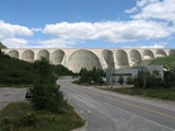
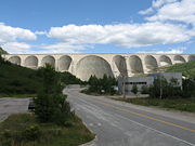
. Côte-Nord's fourteen hydroelectric dams, notably the Manicouagan
Manicouagan River
The Manicouagan River is a river in Côte-Nord region of Quebec, Canada. The river originates at the Daniel-Johnson Dam of the Manicouagan Reservoir and flows approximately south, emptying into the Saint Lawrence River near Baie-Comeau...
-Outardes
Rivière aux Outardes
The Rivière aux Outardes or Outardes River is a river in Quebec, Canada. The river originates in the Otish Mountains, and flows in a southerly direction for its entire course. It passes through Lake Plétipi and Burnt Islands Lake , and widens about midway to form the large Outardes 4 Reservoir...
complex, supply Hydro-Québec
Hydro-Québec
Hydro-Québec is a government-owned public utility established in 1944 by the Government of Quebec. Based in Montreal, the company is in charge of the generation, transmission and distribution of electricity across Quebec....
with over 10,500 megawatts of power.
Subdivisions
Regional county municipalitiesRegional county municipality
The term regional county municipality or RCM is used in Quebec to designate one of 86 county-like political and geographic units. In most cases, they are also census divisions. Regional County Municipalities are a supralocal type of "Regional Municipality" and are still commonly referred to as...
- CaniapiscauCaniapiscau Regional County Municipality, QuebecCaniapiscau is a regional county municipality in northeastern Quebec, Canada. The regional county municipality seat is Fermont. It is located in the northwest corner of the Côte-Nord region of Quebec. It has a land area of and a 2006 census population of 3,948 inhabitants, two-thirds of whom lived...
- La Haute-Côte-NordLa Haute-Côte-Nord Regional County Municipality, QuebecLa Haute-Côte-Nord is a Regional County Municipality in northeastern Quebec, Canada. It is located on the Gulf of Saint Lawrence where the Saguenay River flows into it. The Regional County Municipality seat is at Les Escoumins. The municipality has a land area of and a 2006 census population...
- Le Golfe-du-Saint-LaurentLe Golfe-du-Saint-Laurent Regional County Municipality, QuebecLe Golfe-du-Saint-Laurent is a Regional county municipality in the Côte-Nord region of far-eastern Quebec, Canada. It includes all the communities along the Gulf of Saint Lawrence between the Natashquan River and the Newfoundland and Labrador border...
- ManicouaganManicouagan Regional County Municipality, QuebecManicouagan is a Regional County Municipality in the Côte-Nord region of Quebec, Canada. It is located on the north shore of the Saint Lawrence River with its seat in Baie-Comeau...
- MinganieMinganie Regional County Municipality, QuebecMinganie is a regional county municipality of Quebec in Canada. The regional seat is Havre-Saint-Pierre. Anticosti Island is included within this region. It has a land area of ....
- Sept-RivièresSept-Rivières Regional County Municipality, QuebecSept-Rivières is a regional county municipality of Quebec, Canada, in the Côte-Nord region. Its county seat is Sept-Îles.-Geography:Sept-Rivières is located in the central part of Côte-Nord...
Indian reserves
- BetsiamitesBetsiamites, QuebecBetsiamites, also known as Pessamit , is a First Nations reserve and Innu community in the Canadian province of Quebec, located about southwest from Baie-Comeau along the north shore of the Saint Lawrence River at the mouth of the Betsiamites River...
- EssipitEssipit, QuebecEssipit is an Innu Indian reserve and community in the Canadian province of Quebec, located on the north shore of the Gulf of Saint Lawrence in the Côte-Nord region. It belongs to the Innue Essipit First Nation....
- La RomaineLa Romaine, QuebecLa Romaine, also known as Unamenshipit in Innu-aimun, is an Innu First Nations reserve in the Côte-Nord region of Quebec, Canada, at the mouth of the Olomane River on the Gulf of Saint Lawrence. It belongs to the Innu band of Unamen Shipu...
- MatimekoshMatimekosh, QuebecMatimekosh is a First Nations reserve on Lake Pearce in the Côte-Nord region of Quebec, Canada. Together with the Lac-John Reserve, it belongs to the Innu Nation of Matimekush-Lac John...
- MinganMingan, QuebecMingan, also known as Ekuantshit in Innu-aimun, is an Innu First Nations reserve in the Canadian province of Quebec, at the mouth of the Mingan River on Mingan Bay of the Gulf of Saint Lawrence. It belongs to the Innu band of Ekuanitshit...
- Natashquan
- Uashat-Maliotenam
Naskapi reserved territory
- KawawachikamachKawawachikamach, QuebecKawawachikamach is an Naskapi/Iyiyiw First Nations reserve and community at the south end of Lake Matemace , approximately northeast of Schefferville, Quebec, Canada. It belongs to the Naskapi Nation of Kawawachikamach. The village was built by the Naskapi/Iyiyiw from 1980 to 1983...
Major communities
- Baie-Comeau
- Chute-aux-OutardesChute-aux-Outardes, QuebecChute-aux-Outardes is a village in Quebec, Canada, at the mouth of the Outardes River. It is about south-west of Baie-Comeau along Route 138.-Demographics:Population trend:* Population in 2006: 1853...
- FermontFermont, QuebecFermont is a town in northeastern Quebec, Canada, near the Quebec-Labrador border about from Labrador City on Route 389, which connects to the Trans-Labrador Highway...
- ForestvilleForestville, QuebecForestville is a town in the Côte-Nord region of Quebec, Canada. It is located on the north shore of the Saint Lawrence River along Route 138, approximately southwest of Baie-Comeau. There is a vehicle and passenger ferry service from Forestville to Rimouski, on the south shore of the St. Lawrence...
- Havre-Saint-PierreHavre-Saint-Pierre, QuebecHavre-Saint-Pierre is a town situated on Pointe-aux-Esquimaux, which is on the Quebec north shore of the Saint Lawrence River in Canada...
- Les EscouminsLes Escoumins, QuebecLes Escoumins is a village on the shore of the Saint Lawrence River in the Haute-Côte-Nord region of the province of Quebec, Canada.Its economy is mostly based on the service sectors, especially education, health, and tourism...
- Pointe-aux-OutardesPointe-aux-Outardes, QuebecPointe-aux-Outardes is a village in Quebec, Canada, on the southern point of the Manicouagan Peninsula between the mouths of the Outardes and Manicouagan Rivers....
- Pointe-LebelPointe-Lebel, QuebecPointe-Lebel is a village in the Côte-Nord region of Quebec, Canada. Its territory makes up the western half of the Manicouagan Peninsula between the mouths of the Outardes and Manicouagan Rivers.-Demographics:Population trend:...
- Port-CartierPort-Cartier, QuebecPort-Cartier is a town in the Côte-Nord region of Quebec, Canada. It is located on the north shore of the Saint Lawrence River at the mouth of the Rochers River, exactly southwest of Sept-Îles, Quebec....
- Sacré-CoeurSacré-Coeur, QuebecSacré-Coeur is a municipality in the Côte-Nord region of the province of Quebec in Canada.-Demographics:Population trend:* Population in 2006: 2024 * Population in 2001: 2053* Population in 1996: 2081...
- Sept-ÎlesSept-Îles, QuebecFor the islands in north of Brittany, see JentilezSept-Îles is a city in the Côte-Nord region of eastern Quebec, Canada. It is the northernmost town in Quebec with any significant population...